Fish Inventories of Mid-Atlantic and Northeast Coastal and Barrier Network Parks within Virginia, Maryland and Pennsylvania 2004 Annual Report
|
|
|
- Jeffry Burns
- 5 years ago
- Views:
Transcription

1 Fish Inventories of Mid-Atlantic and Northeast Coastal and Barrier Network Parks within Virginia, Maryland and Pennsylvania 2004 Annual Report James B. Atkinson Wildlife/Fisheries Biologist Natural Resources Branch Division of Natural and Cultural Resources Shenandoah National Park February, 2005
2 Cover Photo: Multi-agency crew electrofishing the upper Appomattox River within Appomattox Court House National Historical Park. Table of Contents List of Tables... ii List of Maps... iii List of Appendices... iv Abstract...1 Introduction/Background...3 Objectives...4 Study Area Descriptions...4 Methods...8 Results...9 Discussion and Management Recommendations...17 Recommendations for Future Years...19 Literature Cited...19 List of Tables 1. Streams Sampled within Six Mid-Atlantic and One Northeast Coastal and Barrier Network Parks during Fish Species Inventory and Capture Totals by Park during Fish Species Inventory and Capture Totals from Appomattox Court House National Historical Park in Fish Species Inventory and Capture Totals from Booker T. Washington National Monument in Fish Species Inventory and Capture Totals from Fredericksburg and Spotsylvania National Military Park in ii
3 6. Fish Species Inventory and Capture Totals from Gettysburg National Military Park in Fish Species Inventory and Capture Totals from Eisenhower National Historic Site in Fish Species Inventory and Capture Totals from Valley Forge National Historical Park in Fish Species Observed within Valley Forge National Historical Park in Fish Species Inventory and Capture Totals from George Washington Birthplace National Monument in Cumulative Fish Species Inventory and Capture Totals by Park during all Years: List of Maps Fish Inventories of Mid-Atlantic & Northeast Coastal and Barrier Network Parks Legend for Maps of Specific Sample Sites within each Park Appomattox River, Sites APCO01, APCO02 & APCO04; Appomattox NHP Gill s Creek, Site BOWA01; Booker T. Washington National Monument Hazel Run, Site FRSP01; Fredericksburg and Spotsylvania NMP Wilderness Run, Site FRSP07; Fredericksburg and Spotsylvania NMP Rock Creek, Site GETT04; Gettysburg National Military Park Plum Run (East), Site GETT06; Gettysburg National Military Park Plum Run (West), Sites GETT01 GETT03; Gettysburg NMP Marsh Creek, Sites EISE01 & EISE03; Eisenhower NHS Willoughby Run, Site EISE02; Eisenhower NHS Schuylkill River, Boat Transect; Valley Forge NHP iii
4 Bridge s Creek, Site GEWA29; George Washington Birthplace NM Pope s Creek, Sites GEWA02, GEWA04, GEWA14 and GEWA19 GEWA28, GEWA30 & GEWA31 George Washington Birthplace NM Potomac River, Site GEWA24; George Washington Birthplace NM Appendices Appendix A: List of Fish Species Collected Appendix B: Breakdown of Budget by type of Expenditure Appendix C: Photographs iv
5 Fish Inventories of Mid-Atlantic and Northeast Coastal and Barrier Network Parks Within Virginia, Maryland and Pennsylvania 2004 Annual Report Start Date: May 18, 2004 End Date: September 29, 2004 Principal Investigator: Jim Atkinson Field Personnel: David Demarest, Lead Biological Technician, GS-7 Matthew Overstreet, Biological Technician, GS-5 Ben Carswell, Biological Technician, GS-5 Amy Stewart, Biological Technician, GS-5 Leyland del Re, Biological Technician, GS-4 Chris Carson, Biological Technician, GS-4 Gail Morris, SCA Volunteer Tanner Steeves, SCA Volunteer Funding Source: Mid Atlantic Network Inventory Funds, Northeast Coastal and Barrier Network Funds and Shenandoah Park Base Funding Amount for Year: $4,333 from Mid-Atlantic Network; $8,440 from Northeast Coastal and Barrier Network and $21,581 from the Shenandoah Park Base. Total = $34,354 Account Numbers: 2108-NII, NII and NZI Abstract: During the third year of the Mid-Atlantic Network (MIDN) Park fish species inventory, several sites within each of Fredericksburg and Spotsylvania National Military Park (FRSP), Appomattox Court House National Historical Park (APCO), and Booker T. Washington National Monument (BOWA), were resampled from among those initially sampled during 2002 and 2003 effectively completing the inventory of fish species within those three parks. Fish inventories within Valley Forge National Historical Park (VAFO) were also completed this year with the addition of a section of the Schuylkill River sampled by the Pennsylvania Fish and Boat Commission (PFBC). Also this year, the inventory was expanded to include Gettysburg National Military Park (GETT) and Eisenhower National Historic Site (EISE). Additionally, George Washington Birthplace National Monument (GEWA), a component of the Northeast Coastal and Barrier Network (NCBN), was sampled extensively during 2004 as a follow-up to the preliminary 2003 sampling effort. Multiple electrofishing techniques were employed for inventories within the MIDN parks during 2004 including backpack, towed and boat mounted gear. Towed and boat mounted gear and personnel were provided courtesy of the Virginia Department of Game and Inland Fisheries (VDGIF) and the PFBC. Sampling within the expansive aquatic habitats of GEWA was accomplished to a large degree with a cooperative 1
6 agreement with the U.S. Fish and Wildlife Service (USFWS). A variety of sampling methods were employed within GEWA including the use of fyke nets, trawls, seines, and angling gear. The combined sampling efforts within all parks during 2004 included 36 sites along 13 streams or other aquatic habitats. A total of 86 fish species were identified from over 26,000 individual fish captured at all of the sites combined during Species diversity ranged from 8 within the Schuylkill River at VAFO to 31 within streams sampled at FRSP and EISE. Within every stream that was resampled during 2004, two or more new fish species were detected in addition to the range of species encountered during the initial 2002 or 2003 site visits. The cumulative fish inventory effort from all streams and sites from all years include a total of 100 species from 44,076 individual fish captured. Cumulative fish species diversity within individual parks ranged from 8 at Thomas Stone National Historic Site (THST) to 41 at FRSP. Significant Findings The diversity and high density of fishes encountered in the red shale/sandstone/limestone streams within EISE. A total of 16,851 fish representing 31 species were captured at EISE in less than two days of electrofishing within two park streams. The documentation of bigeye jumprock (Scartomyzon ariommus), a globally rare Catostomid (sucker family) within Gills Creek at BOWA. Nearly one third of the fish community diversity within Gills Creek is comprised of Catostomids. A total of 10 species have been detected within the section that flows through or adjacent to BOWA. A population of mottled sculpin (Cottus bairdi) encountered in the central Piedmont (Wilderness Run, FRSP). Within Virginia, these fish are more typical of coldwater streams in the Blue Ridge and Valley and Ridge physiographic provinces. Disjunct to distant mottled sculpin population isolates within Virginia only occur within the Rappahannock and James drainages. A population of silverjaw minnows (Ericymba buccata) encountered in the upper Coastal Plain (Hazel Run, FRSP). This is the only known record of the species within the Rappahannock Drainage from the upper Coastal Plain. These fish more typically occur in the central to upper Piedmont regions of the drainage. The detection of introduced flathead catfish (Pylodictus olivaris) within the Schuylkill River section that flows through VAFO and the associated absence of a sunfish (Lepomis) population within the sample section. These fish have been gradually introduced into a number of Atlantic slope drainages from the Mississippi basin since the mid 1960s and have since become well established within some systems. A total of 34 fish species have been detected within GEWA from the sum of survey efforts over the past two years. The expansive Pope s Creek system is dominated by 2
7 white perch (Morone americana). Of the various sampling techniques employed within the Pope s Creek system including electrofishing, trawling, seining, minnow traps, eel pots, fyke nets and angling, fyke nets proved to be the most efficient technique followed by seine hauls and angling. There are a number of established fish populations throughout the MIDN parks that are the result of introduction. These include members of the Centrarchid family (sunfish and bass) that have been widely dispersed throughout the continental United States as the result of state sponsored stocking programs, the flathead catfish, brown trout and fathead minnows encountered within VAFO, the greenside darter and fathead minnow population encountered at EISE and all carp records. While there are currently no listed endangered or threatened species within any aquatic system in any of the parks sampled, several species appear on the Virginia Natural Heritage Vertebrate Watch List. There is also current concern in regards to the status of American eel populations in the eastern United States. Management Recommendations The park lands included in this inventory are relatively small in area and do not generally contain or otherwise have control of the headwaters of aquatic systems present. However, the aquatic systems present within many of the parks contain significant fishery resources. Many if not most streams within these parks will be affected by activities associated with development, agriculture or other disturbances further upstream. Where feasible, park staff should encourage programs and projects that result in improved water quality in areas upstream from the parks. Introduction/Background On April 3, 2001, a scoping meeting at Richmond National Battlefield Park (RICH) was held to plan inventories of vertebrates and vascular plants in the Mid-Atlantic Network (MIDN) parks. The MIDN includes eleven national parks, primarily located within Virginia and Pennsylvania, that contain significant natural resources. An additional three Virginia/Maryland parks representing the Northeast Coastal and Barrier Network (NCBN) were also included in this assessment. In a preliminary search of existing inventory information from MIDN and NCBN parks within Virginia, many gaps were identified in the status of vertebrate groups and most notably with fish. Of ten Virginia/Maryland parks from the combined networks only two (Shenandoah National Park and Colonial National Monument) had any known inventory information for fish. During the late summer of 2002, fish inventory efforts were initiated within five Virginia parks including Booker T. Washington National Monument (BOWA), Appomattox Court House National Historical Park (APCO), Fredericksburg and Spotsylvania National Military Park 3
8 (FRSP), RICH and Petersburg National Battlefield (PETE). Fish species inventories were completed within APCO and BOWA during 2002 due to the comparatively few streams or aquatic habitats contained within each. While most of the streams or other aquatic systems within the other three parks were sampled during 2002, specific conditions including dry sections of streambed or the presence of large ponds deferred the sampling in such areas until 2003 (Atkinson, 2003). During 2003, sampling within the network parks included opportunistic visits during the late spring and summer as weather and associated stream water levels allowed. Where 2002 was the last in a series of drought years extending from the late 1990s, the weather patterns of 2003 resulted in a sudden shift to the wet cycle. Sequential weather systems throughout the spring and summer months produced moderate to high precipitation levels that resulted in runoff swollen streams and extended periods of high water flows throughout the season in many of the MIDN parks. While sampling within some streams proved to be more challenging than normal due to increased water levels, there were several fair to good sampling windows that were thoroughly exploited for electrofishing. In addition to extensive resampling within some aquatic systems at RICH and FRSP and all aquatic systems within PETE during late spring and early summer, many of the aquatic systems within Valley Forge National Historical Park (VAFO) and George Washington Birthplace National Monument (GEWA) were sampled for the first time during late summer (Atkinson, 2004). In the months prior to the 2004 field season, site assessments were conducted by Shenandoah staff of aquatic habitats present within Gettysburg National Military Park (GETT) and Eisenhower National Historic Site (EISE). Preseason planning efforts also sought to cooperatively involve the use of personnel and equipment from the Virginia Department of Game and Inland Fisheries (VDGIF) to accomplish sampling in the large stream habitats within APCO and BOWA and from the Pennsylvania Fish and Boat Commission (PFBC) to assist with large stream sampling at GETT and EISE and to accomplish sampling in the Schuylkill River within VAFO. Additionally, a cooperative agreement was established with the U.S. Fish and Wildlife Service, Gloucester Fishery Resources Office for assistance with sampling efforts at Pope s Creek within GEWA. Objectives Complete the documentation of 90% of fish species present within each of the MIDN and NCBN parks within Virginia, Maryland and Pennsylvania. Study Area Descriptions (2004) Appomattox Court House National Historical Park The land area comprising Appomattox Court House National Historical Park spans an 8.4 mile section of the upper Appomattox River and several small tributaries including Plain Run Branch in the headwater region of the Appomattox River system. The park is located along the boundary of the Piedmont Lowlands and the Piedmont Foothill physiographic provinces (Jenkins 4
9 and Burkhead, 1994) and is within the James drainage in south-central Virginia. The three sections of the Appomattox River (Map 1) that were originally sampled during 2002, were resampled during mid May, 2004 to in an attempt to document additional fish species that were either not present or not detected within these sections of the stream during late summer and the low flow conditions that persisted in The original site along Plain Run Branch was not resampled this year since the original 2002 survey yielded a species mix (albeit reduced) that was also found within the adjacent river. Channel widths within the Appomattox River this year varied slightly from those initially encountered during 2002 due to increased seasonal inflow. Pool depths were obviously greater during the spring, 2004 sample than in Dominant river substrates included bedrock formations, cobble, gravel, pebble, sand, clay, and muck deposits. Booker T. Washington National Monument The land area associated with Booker T. Washington National Monument contains an approximate 0.7 mile section of Gills Creek and an equally short section of Jack-O-Lantern Branch, a minor Gill s Creek tributary. Gills Creek, formerly a tributary of the Blackwater River, is one of several medium sized streams that currently flow into Smith Mountain Lake, which collectively are situated along the western boundary of the Piedmont Foothill physiographic province in southwestern Virginia. This small park is located within the Roanoke Drainage which ultimately drains into Albemarle Sound in northeastern North Carolina. During normal flow levels, the section of Gills Creek adjacent to the park has an average width of 8.7 meters. The entire section of Gill s Creek that flows through or adjacent to the park was sampled during mid May, 2004 in an attempt to document additional fish species that were either not present or not detected within this section of the stream during late summer and the low flow conditions that persisted in Water flows were moderate to high at the time of the May visit and associated stream turbidity was higher than optimal due to a series of recent thunderstorms within the drainage but these factors did not exceed acceptable thresholds for completing the survey as planned. Due to the sharply deep cut nature of the stream bank on both sides of the stream, channel widths within Gill s Creek this year varied only slightly from those initially encountered during Pool depths however, were obviously greater during the spring, 2004 sample than in Jack-O-Lantern Branch was not resampled this year since the original 2002 survey yielded a species mix (albeit reduced) that was also found within the adjacent section of Gill s Creek. Gills Creek flows across deposits of bedrock, clay, sand and gravel. Typical of the land area in the proximity of BOWA, there is an abundance of mica fragments present within the streambed. Fredericksburg & Spotsylvania National Military Park The nine units comprising Fredericksburg and Spotsylvania National Military Park are stratified among portions of the upper Coastal Plain, the Piedmont Lowlands and the Piedmont Foothill physiographic provinces in north-central Virginia. The park also stratifies portions of the York and Rappahannock Drainages which are the only two of Virginia s ten major drainages that occur entirely within the state. The resulting diversity of aquatic habitats sampled included sections along Hazel Run, upper Deep Run and Wilderness Run within the Rappahannock Drainage, and upper Lewis Run, an unnamed tributary of the Ni River and a tributary of the Poni River known locally as Lucy s Pond within the York Drainage. On February 23, 2004, the Embrey Dam on the Rappahannock River at Fredericksburg was breached per plan by U.S. 5
10 military demolition teams. For the first time since the mid 1800s upper reaches of the Rappahannock and Rapidan Rivers were once again available to upstream migrations of spawning fishes, particularly Clupeids (shad). During late March, 2004, opportunistic surveys for spawning shad were conducted within previously sampled sites in Hazel Run and Wilderness Run. These same sites were revisited during September to capitalize on near optimal water levels, conditions that had otherwise proven to be elusive during prior sampling attempts in 2002 and The combination of the early spring and late summer visits to these streams effectively completed fish inventory efforts within the park. Substrates within the section of Hazel Run that flows through the park are dominated by gravel and sand deposits. Substrates encountered within the section of Wilderness Run sampled are more varied including gravel, sand, clay and muck. Gettysburg National Military Park The land area comprising Gettysburg National Military Park is situated within the Northern Piedmont physiographic province in southern Pennsylvania. Principal aquatic systems within the park include a two mile section (approximate) of Rock Creek and two Rock Creek tributaries, both named Plum Run. The westernmost Plum Run drains the southern section of the park and flows southward past the Round Tops and through the Devil s Den area prior to exiting the park. The easternmost Plum Run drains the East Cavalry Battlefield Site. Rock Creek is a principal tributary of the Monocacy River system, the only component of the Potomac drainage that extends into Pennsylvania. Sections of Rock Creek in the immediate vicinity of the park drain a mix of agricultural and urban landscapes and there is a wastewater treatment plant along the stream within the town of Gettysburg that was constructed in the mid-1980s. Both Plum Runs drain areas of limited agricultural use within areas of the park that receive moderate to heavy public use, primarily along auto tour routes. There was no literature within the park indicating any previous systematic surveys of fishes within Rock Creek or either of the Plum Runs. During the late summer visits to the park, water flow and associated turbidity were reduced to near optimal levels for fish sampling efforts. The remnants of tropical storms Bonnie and Charley had only recently either narrowly missed or grazed areas in the vicinity of the park in what eventually proved to be one of the most active tropical storm seasons of recent record in the Mid Atlantic region. The park sections of Rock Creek flow through an area dominated by large, unconsolidated diabase boulders, many of which line the streambed. In addition to the large boulder substrates, the streambed includes cobble and gravel beds composed of shale, sandstone and limestone, all covered with silt. With the exception of the large diabase boulder outcrop in the Devil s Den area, substrates within both of the Plum Runs were dominated by cobble and gravel composed of mudstone, shale, sandstone and limestone. Eisenhower National Historic Site Adjacent to the southwestern boundary of Gettysburg Battlefield, the land area comprising the Eisenhower National Historic Site contains a 0.3 mile section of Marsh Creek and a 0.7 mile section of the Marsh Creek tributary, Willoughby Run. Marsh Creek is the other principal tributary along with Rock Creek of the Monocacy River system. Both streams drain extensive agricultural landscapes upstream of the park. Marsh Creek is a large stream with widths that vary from 5 to nearly 15 meters within the park. The upstream boundary crosses the stream in the vicinity of a municipal dam and associated impounded section. Downstream of the dam, the 6
11 channel braids around several islands which collectively reform into a single channel several hundred meters prior to exiting the park. Marsh Creek was recently (2001 and 2002) subjected to a fairly extensive fish species inventory associated with an evaluation of municipal water supply operations on aquatic habitats within the stream (Normandeau Associates, Inc, 2004). The park section of Willoughby Run flows nearly parallel to and within 0.2 miles to the east of Marsh Creek. Willoughby Run is much smaller with main channel widths averaging between 3 and 8 meters within the park section. Both streams flow across extensive red shale and sandstone substrates interspersed with thin beds of limestone. Dominant streambed substrates include cobble, gravel and areas of exposed bedrock, all covered extensively with silt. During the late summer visit to the park, water flow and associated turbidity were reduced to near optimal levels for fish sampling efforts. The remnants of tropical storms Bonnie and Charley had likewise only recently either narrowly missed or grazed areas in the vicinity of the park. Valley Forge National Historical Park The land area comprising Valley Forge National Historical Park is situated within the Northern Piedmont physiographic province in southeastern Pennsylvania. The principal aquatic systems within the park include a three mile section (approximate) of the Schuylkill River, the lower two miles of Valley Creek including its confluence with the Schuylkill and 12 named tributaries of the two. The Schuylkill River is the largest tributary of the Delaware River, the principal aquatic system comprising the Delaware drainage that ultimately flows into Delaware Bay. Both the Schuylkill River and Valley Creek flow through heavily developed urban landscapes prior to entering the park. In addition to development associated alterations to water quality and drainage patterns, the watershed in the immediate vicinity of the park (3 miles upstream and 1 mile downstream) contain 38 point and non point sources of industrial/hazardous waste including three superfund sites. As in the case with EISE, there has been some systematic sampling for fish within the park prior to the current effort led by Shenandoah staff. Much if not all of the baseline data is associated with Valley Creek. The Pennsylvania Fish and Boat Commission (PFBC) maintains a long term monitoring transect with emphasis on the brown trout fishery on a section of Valley Creek just upstream of State Route 23. Sampling efforts associated with the MIDN fish species inventory during 2004 were limited to the three mile section of the Schuylkill River that flows through the park. The section sampled during 2004 ranged from the Route 422 bridge (downstream) to the Pawling Road Bridge (upstream). This section of the river varies between 100 and 200 meters in width, contains a mix of pool and riffle habitats and includes several islands on the downstream end. George Washington Birthplace National Monument George Washington s Birthplace National Monument, a NCBN park, fronts the lower Potomac River within the Coastal Plain of Virginia. The tidally influenced lower Potomac River adjacent to the park is approximately six miles wide, consists primarily of brackish water and contains a diverse mix of fish species more typical of those found within Chesapeake Bay than with freshwater habitats. Along the eastern boundary, the park fronts and encompasses a portion of Pope s Creek, a fairly prominent and expansive Potomac tributary that ranges from a tidal, brackish water estuary in the vicinity of the river to a freshwater system in its upper reaches. Lower Pope s Creek contains a number of small, saltmarsh islands separated by a network of tidal channels. Great Island, located at the upstream end of the island series, is the only island 7
12 within the series that contains upland habitat that supports trees. Dancing Marsh, a tributary of Popes Creek within the park, is fed by a small stream that originates on private land adjacent to the western boundary. Bridges Creek, a much smaller Potomac tributary drains portions of the central and western area of the park. There are also several small freshwater ponds present within the park. Substrates throughout the varied aquatic systems of the park ranged primarily from firm sand in areas of high water flow to deep deposits of muck in backwater areas and ponds. Above average precipitation levels that affected the region during 2003 and in the late summer of 2004, served to decrease the salinity of even the lower reaches of Pope s Creek as evidenced by extensive milfoil beds within nearly all of the backwater areas. Fortunately, there were no precipitation related impacts associated with either of the spring or late summer fish sampling efforts other than the absence of any rays which have been observed within Pope s Creek during dry summers. The salt wedge effect and the associated intrusion of marine fish species (Murdy et al. 1997) from the Atlantic Ocean and Chesapeake Bay, is much more pronounced during drought years in the lower Potomac. The remnants of tropical storms Bonnie and Charley both resulted in significant precipitation in the park and vicinity in the weeks prior to the late summer survey. Within one week (August 31) following the late summer survey, tropical storm Gaston scored a direct hit on the park and vicinity dumping considerable rainfall. Methods Throughout all of the wadable stream habitats within each of five of the six parks sampled during 2004, qualitative backpack electrofishing techniques were employed as described in the Shenandoah Fisheries Monitoring Protocol (Atkinson 2003). Basically, this involves either one or more electrofishing crews depending on stream width, working upstream in a line abreast formation netting every fish that enters and is affected by the electrical field(s) generated. Qualitative techniques involve a single pass through each section with the electrofishing gear as opposed to three-pass or quantitative techniques more commonly employed for population level monitoring. Within each stream, sampling was initiated in downstream or boundary locations. When logistically possible, entire reaches of individual streams within the parks were sampled. This was possible at Gill s Creek (BOWA) and Hazel Run (FRSP). Otherwise, long stream reaches were either sampled from single or multiple large (>200m) transects in the case of Marsh Creek (EISE) and Rock Creek (GETT) or were subdivided into several 100m sections as was the case for the Appomattox River (APCO) and Plum Run West (GETT). Within each stream, attempts were made to include major sections of representative or typical habitat and any unique habitats encountered. Sections of the Appomattox River, Marsh Creek and Rock Creek, were sufficiently wide or deep that towed electrofishing gear were used either in place of or in addition to backpack gear. Towed gear (small boat mounted generator, probes and live well), extend operator flexibility within deep and/or wide pool habitats and are therefore more effective for sampling fish within these habitats than backpack gear. The towed gear units were provided courtesy of the VDGIF for use in the Appomattox River and by the PFBC for use in Rock Creek and Marsh Creek. Sections of the Schuylkill River (VAFO) were sampled with boat mounted electrofishing gear courtesy of the PFBC. 8
13 As was the case in 2003, sampling within the expansive Pope s Creek estuary at GEWA was initiated through a cooperative agreement with the U.S. Fish and Wildlife Service (USFWS), Gloucester Fishery Resources Office. A variety of sampling gear was provided by the USFWS including a 16 boat equipped with an otter trawl, several seine nets ranging from 20 to 100 long, five fyke net traps, two hoop net traps and two eel pots were employed within Pope s Creek and Bridges Creek in attempt to access and capture as many different fish species as possible. A portion of the Shenandoah crew also employed the use of angling gear near the confluence of Pope s Creek with the Potomac River in an attempt to capture some of the larger more mobile fish species suspected of inhabiting the area. Electrofishing was not attempted within Pope s Creek during 2004 based on the poor results obtained in Rather, the core sampling effort employed during both of the extended visits to GEWA were based on fyke net/hoop net arrays set in the lower section of Pope s Creek, along the shoreline of the Potomac River and in the mouth of Bridges Creek. Fyke/hoop nets were arranged either individually or in pairs in a variety of habitats including shallows near the shoreline, backwater areas and channels. The broad reaches of lower Pope s Creek including the main channel and sections of the adjacent Potomac River were sampled with the boat towed otter trawl. The trawl with an opening approximately 10 across was employed for a total of four sweeps of approximately 10 minutes each. Following each sweep with the trawl, captured fish were emptied into an onboard live well and then sorted and counted by species. The shoals in and adjacent to the mouth of Pope s Creek and Bridges Creeks were sampled extensively with multiple hauls using a 20 seine. Additional seine hauls were conducted along the shoreline of the Potomac in both locations. Adjacent shoreline areas were used as processing sites for sorting and counting fish upon the conclusion of each haul. Eel pots baited with canned cat food were set within or along the edge of the main channel in lower Pope s Creek during the August visit only. These were left in place overnight and checked the following morning. In addition to the basic species inventory, the count data provides relative densities for each species at the time of sampling. Specimens were collected and preserved from each park as needed to aid in species identifications. All collected fish were initially fixed in formalin for at least 24 hours and then transferred to a 70% ethanol solution for long-term storage. This collection is located with the fish collection from Shenandoah National Park in the Natural Resources building at the Shenandoah National Park Headquarters. The species and origin of specimens are summarized in Appendix A. As in previous years, a small number of fish including those that could not be correctly assigned to species in the field or in the lab were examined and assigned courtesy of Dr. Robert E. Jenkins at Roanoke College. Results A combined total of 36 sites along 13 streams were sampled during 2004 (Table 1). The total inventory effort at all of the sites, streams and parks combined resulted in a capture of 26,111 individual fish representing 86 species (Table 2). Species diversity and fish numbers encountered within each park were most influenced by a variety of the total number of streams 9
14 and sites sampled or by stream size and the associated diversity of different aquatic habitats represented within each. Appomattox Court House National Historical Park There was considerable agreement between the fish species results of the August, 2002 survey and the May, 2004 survey from the same three sites (Map 1) on the Appomattox River. The principal difference was the detection of three species, American eel (Anguilla rostrata ), chain pickerel (Esox niger ) and largemouth bass (Micropterus salmoides ) during 2004 that were not detected during All three species were captured in the long pool that extends both up and downstream of the Route 24 bridge and were more likely the result of the use of towed electrofishing gear used within this section during 2004 versus the backpack gear used during The only species not captured during the 2004 survey that was detected during 2002 was the bluntnose minnow (Pimephales notatus ). A single bluntnose minnow, regarded as absent within the Appomattox system (Jenkins and Burkhead, 1993) was captured within the downstream APCO01 site during These fish are widely used as bait and the erratic occurrence of the species within much of Virginia is likely the result of introduction. A total of 29 fish species were detected from the three original sample sites along the Appomattox River (Table 3.) during the May, 2004 survey. The most frequently encountered fish (over 50 total individuals) at APCO during 2004 included common shiner (Luxilus cornutus), johnny darter (Etheostoma nigrum), redbreast sunfish (Lepomis auritus), bluehead chub (Nocomis leptocephalus), swallowtail shiner (Notropis procne ), rosefin shiner (Lythrurus ardens), mountain redbelly dace (Phoxinus oreas), fantail darter (Etheostoma flabellare) and, bluegill (Lepomis macrochirus). Redbreast sunfish outnumbered bluegill approximately 2:1. Fish species detected in low numbers (less than 5 total) included longnose dace (Rhinichthys cataractae), longfin darter (Etheostoma longimanum), American eel, northern hogsucker, chain pickerel and, stripeback darter (Percina notogramma). As noted during 2002, one of the highlights from the Appomattox River inventory was the diversity of darters encountered there. All four darter species (fantail, longfin, johnny and stripeback) were found together only in the lower site (APCO01). Longfins were not detected from the middle site (APCO02) and neither longfins nor stipebacks were detected in the upstream site (APCO04). In addition to the darter species detected, two other species, the shield darter (Percina peltata) and the glassy darter (Etheostoma vitreum) both occur within the upper Appomattox River (Jenkins and Burkhead, 1993) but were not detected within the park. The entire Appomattox River system is considered problematic in terms of separating johnny darters from a close relative and nearly identical appearing but separate species, the tessellated darter (Etheostoma olmstedi). The two species within the Appomattox River system consist of integrated, hybrid and/or differentiated fish (Jenkins and Burkhead, 1993). All of the darters examined from park sections of the river conform to the characteristic interrupted infraorbital canal of the johnny darter versus uninterrupted in the tessellated darter. 10
15 Booker T. Washington National Monument The fish community within Gill s Creek is unique within the MIDN for several reasons including: 1) geographic location within the Roanoke drainage which supports one of the most diverse and distinctive fish communities on the Atlantic slope of the United States (Jenkins and Burkhead, 1993); 2) the influence of introduced species from Smith Mountain Lake located approximately three miles downstream; and 3) annual spring redhorse sucker (Moxostoma) spawning runs composed of large numbers of individual fish representing several species. The timing of the 2004 survey during mid May resulted in the detection of six fish species including silver redhorse (Moxostoma anisurum), shorthead redhorse (Moxostoma macrolepidotum), bigeye jumprock (Scartomyzon ariommus), common carp (Cyprinus carpio), white perch (Morone americana) and yellow perch (Perca flavescens) that were not detected during the initial 2002 survey. Conversely, there were six fish species detected during 2002 that were not present within the same section sampled during 2004 that are most likely the result of differences in seasonal distribution patterns related to habitat use, spawning activity and water flow levels. The six species in this latter group include golden redhorse (Moxostoma erythrurum), pumpkinseed (Lepomis gibbosus), rosyside dace (Clinostomus funduloides), white shiner (Luxilus albeolus), creek chub (Semotilus atromaculatus) and, riverweed darter (Etheostoma podostemone). A total of 28 fish species (Table 4) were detected from the entire reach of Gill s Creek that either flows through or adjacent to the park. The most frequently encountered species (over 50 total individuals) at BOWA during May, 2004 included bluehead chub, redbreast sunfish, crescent shiner (Luxilus cerasinus), spottail shiner (Notropis hudsonius), margined madtom (Noturus insignis) and, black jumprock (Scartomyzon cervinus). Fish species detected in low numbers (less than 5 total) included quillback (Carpiodes cyprinus), bigeye jumprock, green sunfish (Lepomis cyanellus), largemouth bass, common carp, swallowtail shiner, mountain redbelly dace, bluntnose minnow, white perch, johnny darter and yellow perch. A total of 34 fish species have been recorded within the park per the combined results of the 2002 and 2004 surveys. As noted during 2002, one of the highlights from the Gill s Creek inventory was the diversity of suckers (Catostomidae) encountered within the stream. From both of the surveys combined (2002 and 2004), a total of 10 Catostomids have been detected including quillback, northern hogsucker, Roanoke hogsucker (Hypentelium roanokense), black jumprock, bigeye jumprock, golden redhorse, shorthead redhorse, silver redhorse, V-lip redhorse (Moxostoma pappillosum) and, white sucker (Catostomus commersonii). Roanoke Drainage endemic species encountered within BOWA that are not generally known to occur within drainages that contain all other MIDN parks include bigeye jumprock, Roanoke hogsucker, white shiner, crescent shiner and riverweed darter. The bigeye jumprock is ranked as a globally rare species owing to its relatively small geographic range and the typically low population densities at which the species persists throughout much of its range. Within the Virginia portion of its range, the bigeye jumprock is ranked as rare to uncommon and is currently listed on the Virginia Natural Heritage Vertebrate Watch List (Roble, 2003). There are currently no proposals for elevating the protective status of the species. 11
16 Fredericksburg & Spotsylvania National Military Park The combined surveys of 2002, 2003 and 2004 within Fredericksburg and Spotsylvania National Military Park have resulted in the detection of the greatest number of fish species (41) encountered within any of the MIDN parks. The large species count is the result of a number of small to medium sized streams stratified from the central Piedmont to the upper Coastal Plain on each side of the Fall Zone. A total of 31 fish species were detected from individual sections of Hazel Run and Wilderness Run sampled both in the early spring and during late summer, 2004 (Table 5). The seasonally stratified surveys on these two streams resulted in the detection of several additional species including mottled sculpin (Cottus bairdii), gizzard shad (Dorosoma cepedianum), silverjaw minnow (Ericymba buccata) and stripeback darter. The mottled sculpin and silverjaw minnow records within the park are particularly noteworthy. Mottled sculpin are more typical of coldwater streams in the Blue Ridge and Valley and Ridge physiographic provinces. Disjunct to distant mottled sculpin population isolates within Virginia only occur in a few scattered locations of the central Piedmont within the Rappahannock and James drainages (Jenkins and Burkhead, 1993). Within Wilderness Run, mottled sculpin were only detected during the early spring (late March) survey and may retreat to sources of spring inflow during the summer months. Silverjaw minnows were only detected within Hazel Run during the late summer (September) survey. This is the only known record of the species within the Rappahannock Drainage from the upper Coastal Plain. These fish more typically occur in the central to upper Piedmont regions of the drainage. Hazel Run originates in the lower Piedmont, flows across the fall zone and enters the Rappahannock River within the upper Coastal Plain. Hazel Run and Wilderness Run contain the greatest diversity of fish species from among all of the other streams and aquatic systems within the park. As the results indicate (Table 5), there are dramatic seasonal differences in the distribution and densities of fish species within these streams as related to water temperature, flow levels and spawning activity. Frequently encountered species within Hazel Run (50 or more individuals detected) include fallfish (Semotilus corporalis), bluehead chub, American eel, white sucker and tessellated darter. Infrequently encountered fish species within Hazel Run (less than five individuals detected) include warmouth (Lepomis gulosus), smallmouth bass (Micropterus dolomieui), gizzard shad, creek chub, yellow bullhead (Ameiurus natalis), margined madtom and sea lamprey (Petromyzon marinus). The two sea lampreys captured during September were both in late stages of transformation from nonparasitic ammocoetes (larvae) to parasitic juveniles. Transformation typically takes place at age six to eight years (Jenkins and Burkhead, 1993). Frequently encountered species within Wilderness Run include white sucker, tessellated darter, creek chubsucker (Erimyzon oblongus), creek chub and bluegill. Infrequently encountered species include warmouth, largemouth bass, blacknose dace (Rhinichthys atratulus), eastern mosquitofish (Gambusia holbrooki) and, stripeback darter. 12
17 Gettysburg National Military Park The streams within Gettysburg National Military Park were sampled for the first time during 2004 as a component of the MIDN fish species inventory. A total of 18 fish species were recorded from three principal park streams (Table 6), during the August and early September visits to the park. Rock Creek, the park s largest stream, contained the greatest diversity of fishes with 16 species encountered. The most frequently encountered species (50 or more individuals detected) include bluntnose minnow, green sunfish, white sucker and greenside darter (Etheostoma blennioides). Within Pennsylvania, the greenside darter and the green sunfish are regarded as native to the Ohio drainage and as probably introduced in the Potomac and other Atlantic slope drainages (Cooper, 1983). The eastern silvery minnows (Hybognathus regius) encountered within Rock Creek are noteworthy to the extent that Cooper does not include any Pennsylvania records from the Potomac drainage but indicates that the species is only common within some streams in the Delaware drainage. Eastern silvery minnows are shown as being broadly distributed and as native from the central Piedmont and Coastal Plain sections of the Potomac drainage within Virginia however (Jenkins and Burkhead, 1993). The only other stream within any of the MIDN parks where eastern silvery minnows have been detected is Hazel Run at FRSP. Sections of Plum Run (west) that were sampled within the park were dominated by blacknose dace, bluntnose minnow, green sunfish and creek chub. This stream also contained the only golden shiner (Notemigonus crysoleucas) population detected within the park, primarily in and above the Devil s Den area. These fish are propagated extensively for use as bait and have been widely introduced both within and beyond their original range through release. The isolated nature of the golden shiner population within Plum Run is more likely the result of introduction than not. Only three fish species (creek chub, blacknose dace and bluegill) were detected within Plum Run (east), the park section of which consists of a small, low flow channel within 0.5 mile of the source spring. Blacknose dace and creek chub persist at relatively high densities within this stream and as such, they appear to be the best adapted species within the park for exploiting the limited habitats present within small headwater streams. Fish species encountered infrequently (less than five individuals detected) within park streams include satinfin shiner (Cyprinella analostana) and banded killifish (Fundulus diaphanous). Eisenhower National Historic Site As with GETT, the streams within Eisenhower National Historic Site were sampled for the first time during 2004 as a component of the MIDN fish species inventory. A total of 16,851 individual fish representing 31 species were captured from Marsh Creek and Willoughby Run (Table 7), during the August and early September visits to the park. Both streams support the highest fish densities per area in comparison to all of the other streams and aquatic systems within the MIDN parks. The high densities encountered within Marsh Creek were largely attributable to the dominance of three fish species including bluntnose minnows (5,564 captured), central stonerollers (3,551 captured) and blacknose dace (1,213 captured). Other 13
18 species that were encountered in fairly large numbers (100 or more individuals detected) included spottail shiners, greenside darters, fantail darters, longnose dace, common shiners, green sunfish and white suckers. Fish species encountered infrequently (less than five individuals detected) within Marsh Creek include rock bass (Ambloplites rupestris), smallmouth bass, redbreast sunfish, yellow bullhead, fathead minnow (Pimephales promelas), and American eel. Two fish species encountered within Marsh Creek, comely shiners (Notropis amoenus) and rosyface shiners (Notropis rubellus) were not otherwise encountered within any other stream in any of the other MIDN parks. This is more a function of the large size of Marsh Creek in comparison to the typically smaller streams that otherwise occur within the MIDN parks since both species favor large stream habitats. Willoughby Run, a much smaller stream, had similar fish densities per area but dominance was principally attributable to two species, banded killifish (1,710 captured) and bluntnose minnows (1,450 captured). Other fish species encountered in fair large numbers (50 or more individuals detected) within Willoughby Run included green sunfish, central stonerollers, spottail shiners, yellow bullheads and greenside darters. Fish species encountered infrequently (less than five individuals detected) within Willoughby Run included common shiners, golden shiners and longnose dace. The common denominators in terms of the principal dietary components of the dominant species include microcrustaceans (bluntnose minnows and banded killifish), small aquatic insects (bluntnose minnows, banded killifish and blacknose dace) and algae (central stonerollers) which were likely present in large quantity during Agricultural runoff and sun exposure are likely the principal contributors of massive seasonal algal blooms. Aquatic macroinvertebrates have not likely been quantified within either of the two streams. Bluntnose minnows are regarded by Cooper, 1983 as one of the most common minnows in Pennsylvania. Their native status within the Potomac drainage is regarded as questionable by Jenkins and Burkhead, 1993, who suspect that the current distribution and abundance of the species within the drainage probably resulted from stocking, naturalization and rapid spread. In a recent investigation of the fish community within Marsh Creek (Normandeau Associates, Inc, 2004), a different mix of species including fantail darters and spottail shiners followed by bluntnose minnows were the most dominant species recorded from their sampling effort. This difference is probably a function of the different sampling strategies employed. The Shenandoah strategy involved the use of a combination of towed and backpack electrofishing gear which effectively spanned the entire stream channel and thus minimized the escapement of highly mobile fish species. The Normandeau group employed a fairly small crew using a towed electrofishing gear unit. Having observed the structure and behavior of the large groups of fish present within the stream, the latter technique likely resulted in considerable escapement of all but species of reduced mobility (darters). 14
19 Valley Forge National Historical Park A survey of the Schuylkill River section that flows through the park was accomplished courtesy of the PFBC via boat mounted electrofishing gear during early October. With average widths in excess of 100 meters, the Schuylkill River is the largest stream present within any of the MIDN parks. A total of 61 fish were actually captured during the survey representing eight species (Table 8). Many more individual fish (152) representing seven species were observed but not captured during the survey (Table 9.) A total of 213 individual fish representing 11 species resulted from combined captures and observations within the river. Species either captured or observed in the largest numbers included common carp (Cyprinus carpio), American shad (Alosa sapidissima) and channel catfish (Ictalurus punctatus). Carp and channel catfish are both introduced species within the Delaware drainage as are smallmouth bass and flathead catfish (Pylodictus olivaris). Within Pennsylvania, smallmouth bass and flathead catfish are regarded as native in the Ohio drainage and introduced elsewhere (Cooper, 1983). Of all species encountered within the river, the flathead catfish were unexpected and were likely introduced intentionally by anglers (Mike Kaufmann, PFBC, personal comm.). The other potential sources mentioned include, 1) possible escapement from Blue Marsh Reservoir, northwest of Reading, Pennsylvania during a flood and, 2) accidental introduction associated with potential mixed lots of primarily channel catfish stock from rearing ponds in Illinois. The associated absence of any sunfish species from the river survey suggests that the flatheads have become fairly well established within that section of the Schuylkill. While juvenile flatheads feed primarily on microcrustaceans and insect larvae (Jenkins and Burkhead, 1993), adults transition to a diet that consists primarily of fish. In another reference from Jenkins and Burkhead, flatheads became the dominant mainstream predator within 15 years following introduction to the Cape Fear River, North Carolina. In this case, the severe decline in other fish species involved catfish species in particular. Within the upper James River in Virginia, redbreast sunfish populations have suffered precipitous population declines due to introduced flatheads (Larry Mohn, VDGIF, personal comm.). Two other fish species detected within the river (American shad and shield darters), have not been otherwise encountered within any of the MIDN parks during the current inventory. The American shad encountered were fingerlings migrating downriver from June, 2004 stock associated with the shad restoration program on the Schuylkill (Mike Kaufmann, personal comm.). Shield darters have also been reported from Valley Creek (previous PFBC surveys), from Marsh Creek (EISE) and as previously mentioned, from sections of the upper Appomattox River near APCO. George Washington Birthplace National Monument During 2004, the lower section of Pope s Creek was sampled extensively during late May and again in late August through a cooperative agreement with the U.S. Fish and Wildlife Service, Gloucester Fishery Resources Office. The use of fyke nets and hoop traps resulted in the capture of large numbers of fish within all of the habitats where they were employed. Seine net hauls and angling provided contrasting results and the sum of the three techniques employed during May and August effectively sampled all of the fish species present within the system during those periods. Both the total number of species and the total number of individual fish captured 15
20 were slightly higher during the May visit than the August visit (Table 10). A total of 1,358 fish representing 24 species were recorded in May and 1,170 fish representing 18 species were captured during August. A combined total of 3,140 individual fish representing 30 species were captured within the park from all techniques, sites and sampling visits during An additional four species were recorded from freshwater habitats within the park during 2003 which increases the known species count for the park to 34. Within all of the systems sampled during 2004, white perch were clearly the dominate fish species taken from the fyke net/hoop trap arrays and are the most dominant large fish species within all of the park s estuarine habitats. Fish species diversity along the shoreline of the Potomac River was considerably reduced likely due to lack of diverse habitat structure. Large numbers of inland silversides (Menidia beryllina), Atlantic silversides (Menidia menidia) and mummichog (Fundulus heteroclitus) were taken from seine hauls around the delta islands in lower Pope s Creek and around the bar habitat at the mouth of the creek. Angling yielded much larger numbers of striped bass (Morone saxatilis) and all of the channel catfish and bluefish (Pomatomus saltatrix) detected during the survey. The single white catfish (Ameiurus catus) recorded was also the result of angling. All of the large catfish captured (some individuals approached 30 inches in length and nearly 10 pounds in weight), proved to be channel catfish by anal ray count and shape. Blue catfish (Ictalurus furcatus) are reputed to exist within the Potomac River but none were detected during from the sum of survey visits. Within Virginia, blue catfish are well established within tidal sections of the Rappahannock and James Rivers via introduction. Fish species captured during May but not in August included Atlantic menhaden (Brevoortia tyrannus), common carp, sheepshead minnow (Cyprinodon variegates), naked goby (Gobiosoma bosc), and northern pipefish (Syngnathus fuscus). Menhaden and carp were captured in fyke nets and sheepshead minnows, naked goby and northern pipefish were captured in seine hauls. Conversely, fish species captured in August but not in May included Alewife (Alosa pseudoharengus), Atlantic needlefish (Strongylura marina) and bluefish. It is also interesting to note that all of the bay anchovies (Anchoa mitchilli) captured, were taken with the otter trawl from channel habitats within Pope s Creek both May and August. Sampling efforts within Bridge s Creek yielded the only black crappie (Pomoxis nigromaculatus) and eastern mosquitofish (Gambusia holbrooki) captured within the park. Data Management During the course of the inventory, a MIDN parks MS Access XP database was created as a medium for fish species inventory data entry, storage and ultimately distribution to the individual parks. The data were entered and verified according to the data management standards established in Atkinson (2003). Additionally, data collected from the Schuylkill River within Valley Forge by the PFBC were entered into the MIDN parks database by SHEN staff during Park specific databases will be available for the individual parks involved along with the annual report. 16
21 Discussion and Management Recommendations The cumulative fish inventory effort from all streams and sites from all years within the two NBCN parks sampled and all MIDN parks (excluding Shenandoah), include a total of 44,076 individual fish captured representing 100 species (Table 11). Within the MIDN parks only, a total of 39,515 individual fish were captured representing 83 species. The remaining 17 species were principally estuarine fish captured within George Washington Birthplace National Monument, a NBCN park. Fish species diversity within the MIDN parks ranged from 14 at Hopewell Furnace National Historic Site (Sharpe and Keener, 2003) to 41species at Fredericksburg and Spotsylvania National Military Park. Within the two NBCN parks sampled, Thomas Stone National Historic Site (THST) and GEWA, a total of 4,561 individual fish were captured representing 39 species. Fish species diversity within the two NCBN parks ranged from 8 at THST to 34 at GEWA. In addition to the references to introduced fish populations above, there are a number of established fish populations throughout the MIDN parks that are the result of introduction. Of the Centrarchids found in Altlantic Slope drainages within Virginia, Maryland and Pennsylvania, rock bass, white crappie (Pomoxis annularis), smallmouth bass, largemouth bass (Micropterus salmoides), and green sunfish (Lepomis cyanellus), have all been introduced and are therefore outside of their original native range. All are now considered as naturalized species and generally accepted as components of the native fish fauna. Within Virginia, Warmouth (Lepomis gulosus) are considered native to the James Drainage but were probably introduced to the York and Rappahannock Drainages (Jenkins and Burkhead, 1994). Rock bass are considered native to the Tennessee and Big Sandy Drainages within Virginia and to the Ohio drainage within Maryland and Pennsylvania all other populations have likely been introduced (Jenkins and Burkhead, 1993). This is also true for populations of largemouth and smallmouth bass. The original native range of the green sunfish included the Tennessee, Big Sandy and New Drainages within Virginia and the Ohio drainage within Maryland and Pennsylvania, all Atlantic slope populations having been introduced. Populations of redbreast sunfish, pumpkinseed, bluegill, mud sunfish, bluespotted sunfish, and flier are the original native Centrarchid species within the Atlantic Slope drainages of the mid Atlantic states. Common carp were first introduced to aquatic systems in the northeastern United States in 1831 from Europe and Asia. During the 1870s, the popularity of carp within the United States increased sharply and the species was broadly propagated and released in a number of states. The earliest record of carp within Virginia waters is about 1880 (Jenkins and Burkhead, 1993). The only population of brown trout (Salmo trutta) within the MIDN aside from Shenandoah National Park occurs in Valley Creek within Valley Forge National Historical Park. The native range of brown trout as summarized in Jenkins and Burkhead, is Iceland, Europe, western Asia and northwestern Africa. Brown trout were first imported to the United States in the form of fertilized eggs in These fish were gradually introduced in aquatic systems during the late 1800s and early 1900s with a sharp increase occurring between 1927 and Since 1961, the 17
22 VDGIF have maintained brown trout stocks in a number of Virginia streams and a considerable number of populations are now naturalized. Another widely distributed species, the fathead minnow is considered native to the north-central Atlantic slope, and the Mississippi basin among other basins well outside of the MIDN. All Virginia populations (Jenkins and Burkhead, 1993) are considered to have been introduced. Although no specific references were found for Pennsylvania, it is likely that populations within southern Pennsylvania, east of the Ohio drainage and south of the Great Lakes basin, are also the result of introduction. There were no state or federally listed threatened or endangered fish species encountered within any of the MIDN or NCBN parks as the result of this inventory. Other than the remark associated with bigeye jumprock above, two other fish, the least brook lamprey (Lampetra aepyptera) and the ironcolor shiner (Notropis chalybaeus), currently appear on the Virginia Natural Heritage Vertebrate Watch List (Roble, 2003). Both fish occur together within Beaverdam Creek at Richmond National Battlefield Park. A population of least brook lamprey was also detected within Harrison Run at Petersburg National Battlefield. None of the fish species detected within the Pennsylvania component of the MIDN were listed as species of concern with the Pennsylvania Natural Heritage Program. There is current concern in regards to the status of American eel populations within the eastern United States due to recent observed declines in eel numbers and fishery landings in several eastern states including Virginia (Haro, et al. 2000). American eels are currently found within eight MIDN parks including APCO, FRSP, EISE, VAFO, HOFU, RICH, PETE and SHEN and both of the NCBN parks (THST and GEWA) included as components of this inventory. The highest eel densities from among all aquatic systems within all of the parks sampled were detected in Hazel Run (FRSP) and Beaverdam Creek (RICH). The principal management issues that may impact water quality and/or fish populations within MIDN streams or aquatic systems are potential affects from activities associated with development, agriculture or other disturbances upstream of the parks. Within the MIDN parks, this is most pronounced at Valley Forge, where in addition to large scale urban developments, there are a number of sources of hazardous waste affecting the watersheds upstream. Most, if not all of the aquatic systems within the MIDN parks except for Shenandoah, originate on private, municipal or other lands upstream of each park or park unit. While it is generally acknowledged that every aquatic system within Atlantic Slope drainages have been somewhat degraded from pre-colonial conditions, the primary challenge will be to limit future degradations in an attempt to preserve and/or restore water quality and associated fish species assemblages. Where feasible, park staff should encourage programs and projects that result in improved water quality in areas upstream of individual parks or park units. The fish species inventory from the MIDN and NCBN parks will provide park managers with a significant information base in the event that future monitoring is considered or warranted for whatever reason. 18
23 Recommendations for Improving/Altering the Program or Project in Future Years The fish inventory within MIDN and selected NCBC parks is largely complete following the 2004 field season. The only tasks remaining for 2005 include, 1) a series of visits during late winter and spring to BOWA in an attempt to provide additional documentation on the timing and intensity of the redhorse spawning runs and additional documentation including spawning activity and presence of bigeye jumprock within Gills Creek and, 2) a boat mounted electrofishing survey of lower Beaverdam Creek within Richmond Battlefield associated with a conservation easement that is currently under consideration as a potential land exchange. Literature Cited Atkinson, J. B Shenandoah National Park Fisheries Monitoring Protocol. Shenandoah National Park, Division of Natural and Cultural Resources, Luray, VA pp. Atkinson, J. B Virginia Parks Fish Inventory; Mid-Atlantic Network; 2002 Annual Report. Unpubl. Report. Shenandoah National Park, Division of Natural and Cultural Resources, Luray, VA pp. Atkinson, J. B Fish Inventories of Mid-Atlantic and Northeast Coastal and Barrier Network Parks within Virginia, Maryland and Pennsylvania: 2003 Annual Report. Unpubl. Report. Shenandoah National Park, Division of Natural and Cultural Resources, Luray, VA pp. Cooper, E.L Fishes of Pennsylvania and the Northeastern United States. The Pennsylvania State University Press, University Park and London. 243 pp. Haro, A., Richkus, W., Whalen, K., Hoar, A., Busch, W.D., Lary, S., Brush, T., and Dixon, D Population decline of the American eel: Implications for research and management. Fisheries 25(9): Jenkins, R.E., and Burkhead, N.M Freshwater fishes of Virginia. American Fisheries Society, Bethesda, Maryland pp. Murdy, E.O., Birdsong, R.S., and Musick, J.A Fishes of Chesapeake Bay. Smithsonian Institution Press, Washington and London. 324 pp. Normandeau Associates, Inc Evaluation of the Effects of Municipal Water Supply System Operations on Aquatic Habitat in Marsh Creek, Gettysburg, Pennsylvania: Draft Final Report. Spring City, PA. 128 pp. plus figures. Roble, S.M Natural Heritage Resources of Virginia: Rare Animal Species. Natural Heritage Technical Report Virginia Department of Conservation and Recreation, Division of Natural Heritage, Richmond, Virginia. 39 pp. 19
24 Sharpe, W.E. and Keener, A.L Hopewell Furnace National Historic Site Fisheries Survey. Penn State Institutes of the Environment. PSIE pp. 20
25 Tables and Figures 21
26 Table 1. Streams Sampled within Six Mid-Atlantic and One Northeast Coastal and Barrier Network Parks during ParkCode Park AreaID AreaName NumSites APCO Appomattox Court House National Historical Park APPX Appomattox River 3 BOWA Booker T Washington National Monument GILL Gills Creek 1 EISE Eisenhower National Historic Site MARS Marsh Creek 2 EISE Eisenhower National Historic Site WILL Willoughby Run 1 FRSP Fredericksburg & Spotsylvania National Military Park HAZL Hazel Run 1 FRSP Fredericksburg & Spotsylvania National Military Park WILD Wilderness Run 1 GETT Gettysburg National Military Park PLUM_E Plum Run (East) 1 GETT Gettysburg National Military Park PLUM_W Plum Run (West) 3 GETT Gettysburg National Military Park ROCK Rock Creek 1 GEWA George Washington Birthplace National Monument BRIDG Bridge's Creek 2 GEWA George Washington Birthplace National Monument POPE Popes Creek 21 GEWA George Washington Birthplace National Monument POTR Potomac River 2 VAFO Valley Forge National Historical Park SCHR Schuylkill River 1 22
27 Table 2. Fish Species Inventory and Capture Totals by Park during 2004 FAMILY COMMONNAME LATINNAME APCO BOWA FRSP GETT EISE VAFO GEWA Total Anguillidae Eel, American Anguilla rostrata Aphredoderidae Perch, Pirate Aphredoderus sayanus Atherinidae Silverside, Atlantic Menidia menidia Atherinidae Silverside, Inland Menidia beryllina Belonidae Needlefish, Atlantic Strongylura marina Catostomidae Chubsucker, Creek Erimyzon oblongus Catostomidae Hogsucker, Roanoke Hypentelium roanokense Catostomidae Jumprock, Bigeye Scartomyzon ariommus Catostomidae Jumprock, Black Scartomyzon cervinus Catostomidae Quillback Carpiodes cyprinus Catostomidae Redhorse, Shorthead Moxostoma macrolepidotum Catostomidae Redhorse, Silver Moxostoma anisurum Catostomidae Redhorse, V-lip Moxostoma pappillosum Catostomidae Hogsucker, Northern Hypentelium nigricans Catostomidae Sucker, Torrent Moxostoma rhothoecum Catostomidae Sucker, White Catostomus commersonii Centrarchidae Bass, Largemouth Micropterus salmoides Centrarchidae Bass, Rock Ambloplites rupestris Centrarchidae Bass, Smallmouth Micropterus dolomieui Centrarchidae Bluegill Lepomis macrochirus Centrarchidae Crappie, Black Pomoxis nigromaculatus Centrarchidae Pumpkinseed Lepomis gibbosus Centrarchidae Sunfish, Bluespotted Enneacanthus gloriosus Centrarchidae Sunfish, Green Lepomis cyanellus Centrarchidae Sunfish, Redbreast Lepomis auritus Centrarchidae Warmouth Lepomis gulosus Clupeidae Alewife Alosa pseudoharengus Clupeidae Menhaden, Atlantic Brevoortia tyrannus Clupeidae Shad, American Alosa sapidissima Clupidae Shad, Gizzard Dorosoma cepedianum Cottidae Sculpin, Mottled Cottus bairdii
28 Table 2 Continued. Fish Species Inventory and Capture Totals by Park during 2004 FAMILY COMMONNAME LATINNAME APCO BOWA FRSP GETT EISE VAFO GEWA Total Cyprinidae Carp, Common Cyprinus carpio Cyprinidae Chub, Bluehead Nocomis leptocephalus Cyprinidae Chub, Creek Semotilus atromaculatus Cyprinidae Chub, River Nocomis micropogon Cyprinidae Dace, Blacknose Rhinichthys atratulus Cyprinidae Dace, Longnose Rhinichthys cataractae Cyprinidae Dace, Mountain Redbelly Phoxinus oreas Cyprinidae Dace, Rosyside Clinostomus funduloides Cyprinidae Fallfish Semotilus corporalis Cyprinidae Minnow, Bluntnose Pimephales notatus Cyprinidae Minnow, Cutlips Exoglossum maxillingua Cyprinidae Minnow, Eastern Silvery Hybognathus regius Cyprinidae Minnow, Fathead Pimephales promelas Cyprinidae Minnow, Silverjaw Ericymba buccata Cyprinidae Shiner, Comely Notropis amoenus Cyprinidae Shiner, Common Luxilus cornutus Cyprinidae Shiner, Crescent Luxilus cerasinus Cyprinidae Shiner, Golden Notemigonus crysoleucas Cyprinidae Shiner, Rosefin Lythrurus ardens Cyprinidae Shiner, Rosyface Notropis rubellus Cyprinidae Shiner, Satinfin Cyprinella analostana Cyprinidae Shiner, Spotfin Cyprinella spiloptera Cyprinidae Shiner, Spottail Notropis hudsonius Cyprinidae Shiner, Swallowtail Notropis procne Cyprinidae Stoneroller, Central Campostoma anomalum Cyprinodontidae Killifish, Striped Fundulus majalis Cyprinodontidae Minnow, Sheepshead Cyprinodon variegatus Engraulidae Anchovy, Bay Anchoa mitchilli Esocidae Pickeral, Chain Esox niger Fundulidae Killifish, Banded Fundulus diaphanus Fundulidae Mummichog Fundulus heteroclitus
29 Table 2 Continued. Fish Species Inventory and Capture Totals by Park during 2004 FAMILY COMMONNAME LATINNAME APCO BOWA FRSP GETT EISE VAFO GEWA Total Gobiidae Goby, Naked Gobiosoma bosc Ictaluridae Bullhead, Brown Ameiurus nebulosus Ictaluridae Bullhead, Yellow Ameiurus natalis Ictaluridae Catfish, Channel Ictalurus punctatus Ictaluridae Catfish, Flathead Pylodictus olivaris Ictaluridae Catfish, White Ameiurus catus Ictaluridae Madtom, Margined Noturus insignis Moronidae Bass, Striped Morone saxatilis Moronidae Perch, White Morone americana Paralichthyidae Flounder, Summer Paralichthys dentatus Percidae Darter, Fantail Etheostoma flabellare Percidae Darter, Greenside Etheostoma blennioides Percidae Darter, Johnny Etheostoma nigrum Percidae Darter, Longfin Etheostoma longimanum Percidae Darter, Stripeback Percina notogramma Percidae Darter, Tessellated Etheostoma olmstedi Percidae Perch, Yellow Perca flavescens Petromyzontidae Lamprey, Sea Petromyzon marinus Poeciliidae Mosquitofish, Eastern Gambusia holbrooki Pomatomidae Bluefish Pomatomus saltatrix Rercidae Darter, Shield Percina peltata Sciaenidae Spot Leiostomus xanthurus Soleidae Hogchoker Trinectes maculatus Syngnathidae Pipefish, Northern Syngnathus fuscus Total # Individuals 1, ,451 2,587 16, ,140 26,111 Total # Taxa
30 Table 3. Fish Species Inventory and Capture Totals from Appomattox Court House National Historical Park in COMMONNAME FAMILY LATINNAME APCO01 APCO02 APCO04 Total Anguillidae Eel, American Anguilla rostrata Aphredoderidae Perch, Pirate Aphredoderus sayanus Catostomidae Sucker, White Catostomus commersonii Catostomidae Chubsucker, Creek Erimyzon oblongus Catostomidae Hogsucker, Northern Hypentelium nigricans Catostomidae Sucker, Torrent Thoburnia rhothoeca Centrarchidae Sunfish, Redbreast Lepomis auritus Centrarchidae Pumpkinseed Lepomis gibbosus Centrarchidae Bluegill Lepomis macrochirus Centrarchidae Bass, Smallmouth Micropterus dolomieui Centrarchidae Bass, Largemouth Micropterus salmoides Cyprinidae Stoneroller, Central Campostoma anomalum Cyprinidae Dace, Rosyside Clinostomus funduloides Cyprinidae Minnow, Cutlips Exoglossum maxillingua Cyprinidae Shiner, Common Luxilus cornutus Cyprinidae Shiner, Rosefin Lythrurus ardens Cyprinidae Chub, Bluehead Nocomis leptocephalus Cyprinidae Shiner, Swallowtail Notropis procne Cyprinidae Dace, Mountain Redbelly Phoxinus oreas Cyprinidae Dace, Blacknose Rhinichthys atratulus Cyprinidae Dace, Longnose Rhinichthys cataractae Cyprinidae Chub, Creek Semotilus atromaculatus Cyprinidae Fallfish Semotilus corporalis Esocidae Pickeral, Chain Esox niger Ictaluridae Madtom, Margined Noturus insignis Percidae Darter, Fantail Etheostoma flabellare Percidae Darter, Longfin Etheostoma longimanum Percidae Darter, Johnny Etheostoma nigrum Percidae Darter, Stripeback Percina notogramma Total # Individuals ,152 Total # Taxa
31 Table 4. Fish Species Inventory and Capture Totals from Booker T. Washington National Monument in FAMILY COMMONNAME LATINNAME GILL Total Catostomidae Quillback Carpiodes cyprinus 1 1 Catostomidae Sucker, White Catostomus commersonii Catostomidae Hogsucker, Northern Hypentelium nigricans 5 5 Catostomidae Hogsucker, Roanoke Hypentelium roanokense 6 6 Catostomidae Redhorse, Silver Moxostoma anisurum Catostomidae Redhorse, Shorthead Moxostoma macrolepidotum Catostomidae Redhorse, V-lip Moxostoma pappillosum 8 8 Catostomidae Jumprock, Bigeye Scartomyzon ariommus 1 1 Catostomidae Jumprock, Black Scartomyzon cervinus Centrarchidae Sunfish, Redbreast Lepomis auritus Centrarchidae Sunfish, Green Lepomis cyanellus 3 3 Centrarchidae Bluegill Lepomis macrochirus Centrarchidae Bass, Largemouth Micropterus salmoides 1 1 Cyprinidae Stoneroller, Central Campostoma anomalum Cyprinidae Shiner, Satinfin Cyprinella analostana Cyprinidae Carp, Common Cyprinus carpio 2 2 Cyprinidae Shiner, Crescent Luxilus cerasinus Cyprinidae Shiner, Rosefin Lythrurus ardens Cyprinidae Chub, Bluehead Nocomis leptocephalus Cyprinidae Shiner, Spottail Notropis hudsonius Cyprinidae Shiner, Swallowtail Notropis procne 2 2 Cyprinidae Dace, Mountain Redbelly Phoxinus oreas 1 1 Cyprinidae Minnow, Bluntnose Pimephales notatus 3 3 Ictaluridae Madtom, Margined Noturus insignis Moronidae Perch, White Morone americana 1 1 Percidae Darter, Fantail Etheostoma flabellare Percidae Darter, Johnny Etheostoma nigrum 1 1 Percidae Perch, Yellow Perca flavescens 4 4 Total # Individuals Total # Taxa
32 Table 5. Fish Species Inventory and Capture Totals from Fredericksburg and Spotsylvania National Military Park in FAMILY COMMONNAME LATINNAME HAZL SPR HAZL SUM WILD SPR WILD SUM Total Anguillidae Eel, American Anguilla rostrata Catostomidae Sucker, White Catostomus commersonii Catostomidae Chubsucker, Creek Erimyzon oblongus Centrarchidae Sunfish, Redbreast Lepomis auritus Centrarchidae Sunfish, Green Lepomis cyanellus Centrarchidae Pumpkinseed Lepomis gibbosus Centrarchidae Warmouth Lepomis gulosus Centrarchidae Bluegill Lepomis macrochirus Centrarchidae Bass, Smallmouth Micropterus dolomieui Centrarchidae Bass, Largemouth Micropterus salmoides Clupidae Shad, Gizzard Dorosoma cepedianum Cottidae Sculpin, Mottled Cottus bairdii Cyprinidae Dace, Rosyside Clinostomus funduloides Cyprinidae Shiner, Satinfin Cyprinella analostana Cyprinidae Minnow, Silverjaw Ericymba buccata Cyprinidae Minnow, Eastern Silvery Hybognathus regius Cyprinidae Shiner, Common Luxilus cornutus Cyprinidae Chub, Bluehead Nocomis leptocephalus Cyprinidae Shiner, Golden Notemigonus crysoleucas Cyprinidae Shiner, Swallowtail Notropis procne Cyprinidae Dace, Blacknose Rhinichthys atratulus Cyprinidae Dace, Longnose Rhinichthys cataractae Cyprinidae Chub, Creek Semotilus atromaculatus Cyprinidae Fallfish Semotilus corporalis Ictaluridae Bullhead, Yellow Ameiurus natalis Ictaluridae Bullhead, Brown Ameiurus nebulosus Ictaluridae Madtom, Margined Noturus insignis Percidae Darter, Tessellated Etheostoma olmstedi Percidae Darter, Stripeback Percina notogramma Petromyzontidae Lamprey, Sea Petromyzon marinus Poeciliidae Mosquitofish, Eastern Gambusia holbrooki Total # Individuals ,451 Total # Taxa
33 Table 6. Fish Species Inventory and Capture Totals from Gettysburg National Military Park in FAMILY COMMONNAME LATINNAME ROCK PLUM_E PLUM_W Total Catostomidae Sucker, White Catostomus commersonii Centrarchidae Sunfish, Redbreast Lepomis auritus Centrarchidae Sunfish, Green Lepomis cyanellus Centrarchidae Pumpkinseed Lepomis gibbosus Centrarchidae Bluegill Lepomis macrochirus Centrarchidae Bass, Largemouth Micropterus salmoides Cyprinidae Stoneroller, Central Campostoma anomalum Cyprinidae Shiner, Satinfin Cyprinella analostana Cyprinidae Minnow, Eastern Silvery Hybognathus regius Cyprinidae Shiner, Golden Notemigonus crysoleucas Cyprinidae Minnow, Bluntnose Pimephales notatus Cyprinidae Dace, Blacknose Rhinichthys atratulus Cyprinidae Dace, Longnose Rhinichthys cataractae Cyprinidae Chub, Creek Semotilus atromaculatus Fundulidae Killifish, Banded Fundulus diaphanus Ictaluridae Bullhead, Yellow Ameiurus natalis Percidae Darter, Greenside Etheostoma blennioides Percidae Darter, Fantail Etheostoma flabellare Total # Individuals ,166 2,587 Total # Taxa
34 Table 7. Fish Species Inventory and Capture Totals from Eisenhower National Historic Site in FAMILY COMMONNAME LATINNAME MARS WILL Total Anguillidae Eel, American Anguilla rostrata Catostomidae Sucker, White Catostomus commersonii Catostomidae Hogsucker, Northern Hypentelium nigricans Centrarchidae Bass, Rock Ambloplites rupestris Centrarchidae Sunfish, Redbreast Lepomis auritus Centrarchidae Sunfish, Green Lepomis cyanellus Centrarchidae Pumpkinseed Lepomis gibbosus Centrarchidae Bluegill Lepomis macrochirus Centrarchidae Bass, Smallmouth Micropterus dolomieui Centrarchidae Bass, Largemouth Micropterus salmoides Centrarchidae Crappie, Black Pomoxis nigromaculatus Cyprinidae Stoneroller, Central Campostoma anomalum Cyprinidae Shiner, Spotfin Cyprinella spiloptera Cyprinidae Minnow, Cutlips Exoglossum maxillingua Cyprinidae Shiner, Common Luxilus cornutus Cyprinidae Chub, River Nocomis micropogon Cyprinidae Shiner, Golden Notemigonus crysoleucas Cyprinidae Shiner, Comely Notropis amoenus Cyprinidae Shiner, Spottail Notropis hudsonius Cyprinidae Shiner, Rosyface Notropis rubellus Cyprinidae Minnow, Bluntnose Pimephales notatus Cyprinidae Minnow, Fathead Pimephales promelas Cyprinidae Dace, Blacknose Rhinichthys atratulus Cyprinidae Dace, Longnose Rhinichthys cataractae Cyprinidae Chub, Creek Semotilus atromaculatus Fundulidae Killifish, Banded Fundulus diaphanus Ictaluridae Bullhead, Yellow Ameiurus natalis Ictaluridae Madtom, Margined Noturus insignis Percidae Darter, Greenside Etheostoma blennioides Percidae Darter, Fantail Etheostoma flabellare Percidae Darter, Tessellated Etheostoma olmstedi Total # Individuals 12,892 3,959 16,851 Total # Taxa
35 Table 8. Fish Species Inventory and Capture Totals from Valley Forge National Historical Park in FAMILY COMMONNAME LATINNAME SCHR Total Centrarchidae Bass, Smallmouth Micropterus dolomieui Clupeidae Shad, American Alosa sapidissima 3 3 Cyprinidae Shiner, Satinfin Cyprinella analostana 3 3 Cyprinidae Shiner, Spottail Notropis hudsonius Ictaluridae Catfish, Channel Ictalurus punctatus Ictaluridae Catfish, Flathead Pylodictus olivaris 3 3 Percidae Darter, Tessellated Etheostoma olmstedi 4 4 Rercidae Darter, Shield Percina peltata 1 1 Total # Individuals Total # Taxa 8 8 Table 9. Fish Species Observed within Valley Forge National Historical Park in FAMILY COMMONNAME LATINNAME SCHR Total Anguillidae Eel, American Anguilla rostrata 6 6 Clupeidae Shad, American Alosa sapidissima Cyprinidae Carp, Common Cyprinus carpio Catostomidae Sucker, White Catostomus commersonii 1 1 Centrarchidae Bass, Smallmouth Micropterus dolomieui 1 1 Ictaluridae Catfish, Channel Ictalurus punctatus Ictaluridae Catfish, Flathead Pylodictus olivaris 1 1 Total # Individuals Total # Taxa
36 Table 10. Fish Species Inventory and Capture Totals from George Washington Birthplace National Monument in FAMILY COMMONNAME LATINNAME BRIDG POPE_MY POPE_AG POPE_SP POTR Total Anguillidae Eel, American Anguilla rostrata Atherinidae Silverside, Inland Menidia beryllina Atherinidae Silverside, Atlantic Menidia menidia Belonidae Needlefish, Atlantic Strongylura marina Centrarchidae Sunfish, Bluespotted Enneacanthus gloriosus Centrarchidae Pumpkinseed Lepomis gibbosus Centrarchidae Bluegill Lepomis macrochirus Centrarchidae Crappie, Black Pomoxis nigromaculatus Clupeidae Alewife Alosa pseudoharengus Clupeidae Menhaden, Atlantic Brevoortia tyrannus Clupidae Shad, Gizzard Dorosoma cepedianum Cyprinidae Carp, Common Cyprinus carpio Cyprinodontidae Minnow, Sheepshead Cyprinodon variegatus Cyprinodontidae Killifish, Striped Fundulus majalis Engraulidae Anchovy, Bay Anchoa mitchilli Fundulidae Killifish, Banded Fundulus diaphanus Fundulidae Mummichog Fundulus heteroclitus Gobiidae Goby, Naked Gobiosoma bosc Ictaluridae Catfish, White Ameiurus catus Ictaluridae Bullhead, Brown Ameiurus nebulosus Ictaluridae Catfish, Channel Ictalurus punctatus Moronidae Perch, White Morone americana Moronidae Bass, Striped Morone saxatilis Paralichthyidae Flounder, Summer Paralichthys dentatus Percidae Perch, Yellow Perca flavescens Poeciliidae Mosquitofish, Eastern Gambusia holbrooki Pomatomidae Bluefish Pomatomus saltatrix Sciaenidae Spot Leiostomus xanthurus Soleidae Hogchoker Trinectes maculatus Syngnathidae Pipefish, Northern Syngnathus fuscus Total # Individuals Total # Taxa
37 Table 11. Cumulative Fish Species Inventory and Capture Totals by Park during all Years: FAMILY COMMONNAME LATINNAME APCO BOWA FRSP GETT EISE VAFO HOFU RICH PETE GEWA THST Total Amiidae Bowfin Amia calva Anguillidae Eel, American Anguilla rostrata Aphredoderidae Perch, Pirate Aphredoderus sayanus Atherinidae Silverside, Atlantic Menidia menidia Atherinidae Silverside, Inland Menidia beryllina Belonidae Needlefish, Atlantic Strongylura marina Catostomidae Chubsucker, Creek Erimyzon oblongus Catostomidae Hogsucker, Roanoke Hypentelium roanokense Catostomidae Jumprock, Bigeye Scartomyzon ariommus Catostomidae Jumprock, Black Scartomyzon cervinus Catostomidae Quillback Carpiodes cyprinus Catostomidae Redhorse, Golden Moxostoma erythrurum Catostomidae Redhorse, Shorthead Moxostoma macrolepidotum Catostomidae Redhorse, Silver Moxostoma anisurum Catostomidae Redhorse, V-lip Moxostoma pappillosum Catostomidae Hogsucker, Northern Hypentelium nigricans Catostomidae Sucker, Torrent Moxostoma rhothoecum Catostomidae Sucker, White Catostomus commersonii Centrarchidae Bass, Largemouth Micropterus salmoides Centrarchidae Bass, Rock Ambloplites rupestris Centrarchidae Bass, Smallmouth Micropterus dolomieui Centrarchidae Bluegill Lepomis macrochirus Centrarchidae Crappie, Black Pomoxis nigromaculatus Centrarchidae Crappie, White Pomoxis annularis Centrarchidae Flier Centrarchus macropterus Centrarchidae Pumpkinseed Lepomis gibbosus Centrarchidae Spotted Bass Micropterus punctulatus Centrarchidae Sunfish, Bluespotted Enneacanthus gloriosus Centrarchidae Sunfish, Green Lepomis cyanellus Centrarchidae Sunfish, Mud Acantharchus pomotis Centrarchidae Sunfish, Redbreast Lepomis auritus
38 Table 11 Continued. Cumulative Fish Species Inventory and Capture Totals by Park during all Years: FAMILY COMMONNAME LATINNAME APCO BOWA FRSP GETT EISE VAFO HOFU RICH PETE GEWA THST Total Centrarchidae Warmouth Lepomis gulosus Clupeidae Alewife Alosa pseudoharengus Clupeidae Menhaden, Atlantic Brevoortia tyrannus Clupeidae Shad, American Alosa sapidissima Clupidae Shad, Gizzard Dorosoma cepedianum Cottidae Sculpin, Mottled Cottus bairdii Cyprinidae Carp, Common Cyprinus carpio Cyprinidae Chub, Bluehead Nocomis leptocephalus Cyprinidae Chub, Creek Semotilus atromaculatus Cyprinidae Chub, River Nocomis micropogon Cyprinidae Dace, Blacknose Rhinichthys atratulus Cyprinidae Dace, Longnose Rhinichthys cataractae Cyprinidae Dace, Mountain Redbelly Phoxinus oreas Cyprinidae Dace, Rosyside Clinostomus funduloides Cyprinidae Fallfish Semotilus corporalis Cyprinidae Minnow, Bluntnose Pimephales notatus Cyprinidae Minnow, Cutlips Exoglossum maxillingua Cyprinidae Minnow, Eastern Silvery Hybognathus regius Cyprinidae Minnow, Fathead Pimephales promelas Cyprinidae Minnow, Silverjaw Ericymba buccata Cyprinidae Shiner, Comely Notropis amoenus Cyprinidae Shiner, Common Luxilus cornutus Cyprinidae Shiner, Crescent Luxilus cerasinus Cyprinidae Shiner, Golden Notemigonus crysoleucas Cyprinidae Shiner, Ironcolor Notropis chalybaeus Cyprinidae Shiner, Rosefin Lythrurus ardens Cyprinidae Shiner, Rosyface Notropis rubellus Cyprinidae Shiner, Satinfin Cyprinella analostana Cyprinidae Shiner, Spotfin Cyprinella spiloptera Cyprinidae Shiner, Spottail Notropis hudsonius Cyprinidae Shiner, Swallowtail Notropis procne
39 Table 11 Continued. Cumulative Fish Species Inventory and Capture Totals by Park during all Years: FAMILY COMMONNAME LATINNAME APCO BOWA FRSP GETT EISE VAFO HOFU RICH PETE GEWA THST Total Cyprinidae Shiner, White Luxilus albeolus Cyprinidae Stoneroller, Central Campostoma anomalum Cyprinodontidae Killifish, Striped Fundulus majalis Cyprinodontidae Minnow, Sheepshead Cyprinodon variegatus Engraulidae Anchovy, Bay Anchoa mitchilli Esocidae Pickeral, Chain Esox niger Fundulidae Killifish, Banded Fundulus diaphanus Fundulidae Mummichog Fundulus heteroclitus Gobiidae Goby, Naked Gobiosoma bosc Ictaluridae Bullhead, Brown Ameiurus nebulosus Ictaluridae Bullhead, Yellow Ameiurus natalis Ictaluridae Catfish, Channel Ictalurus punctatus Ictaluridae Catfish, Flathead Pylodictus olivaris Ictaluridae Catfish, White Ameiurus catus Ictaluridae Madtom, Margined Noturus insignis Moronidae Bass, Striped Morone saxatilis Moronidae Perch, White Morone americana Paralichthyidae Flounder, Summer Paralichthys dentatus Percidae Darter, Fantail Etheostoma flabellare Percidae Darter, Greenside Etheostoma blennioides Percidae Darter, Johnny Etheostoma nigrum Percidae Darter, Longfin Etheostoma longimanum Percidae Darter, Riverweed Etheostoma podostemone Percidae Darter, Stripeback Percina notogramma Percidae Darter, Swamp Etheostoma fusiforme Percidae Darter, Tessellated Etheostoma olmstedi Percidae Perch, Yellow Perca flavescens Petromyzontidae Lamprey, Least Brook Lampetra aepyptera Petromyzontidae Lamprey, Sea Petromyzon marinus Poeciliidae Mosquitofish, Eastern Gambusia holbrooki Pomatomidae Bluefish Pomatomus saltatrix
40 Table 11 Continued. Cumulative Fish Species Inventory and Capture Totals by Park during all Years: FAMILY COMMONNAME LATINNAME APCO BOWA FRSP GETT EISE VAFO HOFU RICH PETE GEWA THST Total Rercidae Darter, Shield Percina peltata Salmonidae Trout, Brook Salvelinus fontinalis Salmonidae Trout, Brown Salmo trutta Sciaenidae Spot Leiostomus xanthurus Soleidae Hogchoker Trinectes maculatus Syngnathidae Pipefish, Northern Syngnathus fuscus Umbridae Mudminnow, Eastern Umbra pygmaea Total # Individuals Total # Taxa
41 Maps 37
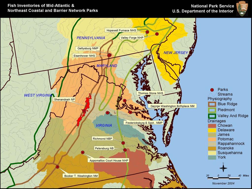
42 38
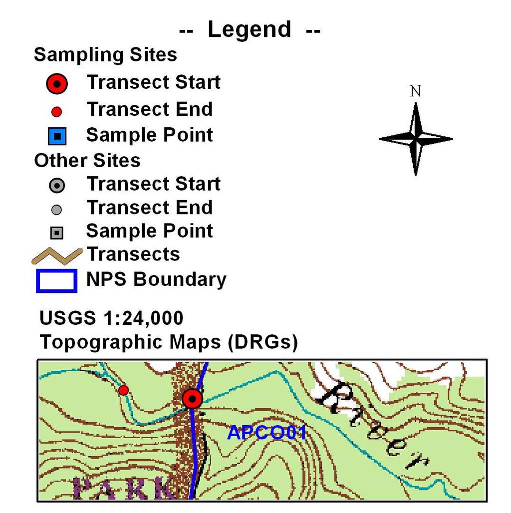
43 Maps 39


44 Map 1: Park: Appomattox Court House National Historical Park Map 2: Park: Booker T. Washington National Monument 40


45 Map 3: Park: Fredericksburg and Spotsylvania National Military Park Map 4: Park: Fredericksburg and Spotsylvania National Military Park 41


46 Map 5: Park: Gettysburg National Military Park Map 6: Park: Gettysburg National Military Park 42


47 Map 7: Park: Gettysburg National Military Park Map 8: Park: Eisenhower National Historic Site 43


48 Map 9: Park: Eisenhower National Historic Site Map 10: Valley Forge National Historical Park 44


49 Map 11: Park: George Washington Birthplace National Monument Map 12: Park: George Washington Birthplace National Monument 45

50 Map 13: Park: George Washington Birthplace National Monument 46
51 Appendices 47
52 Appendix A: List of Fish Species Collected Date Species Number Stream Park 20-May-04 Bigeye Jumprock 1 Gill s Creek BOWA 20-May-04 V-lip Redhorse 1 Gill s Creek BOWA 20-May-04 Shorthead Redhorse 1 Gill s Creek BOWA 20-May-04 Green Sunfish 1 Gill s Creek BOWA 20-May-04 Spottail Shiner 2 Gill s Creek BOWA 20-May-04 Johnny Darter 1 Gill s Creek BOWA 25-May-04 Atlantic Menhaden 1 Pope s Creek GEWA 25-May-04 Inland Silverside 6 Pope s Creek GEWA 25-May-04 Striped Killifish 1 Pope s Creek GEWA 25-May-04 Sheepshead Minnow 2 Pope s Creek GEWA 25-May-04 Naked Goby 1 Pope s Creek GEWA 25-May-04 Banded Killifish 1 Pope s Creek GEWA 25-May-04 Mummichog 2 Pope s Creek GEWA 25-May-04 Summer Flounder 1 Pope s Creek GEWA 25-May-04 Northern Pipefish 5 Pope s Creek GEWA 26-May-04 Atlantic Silverside 8 Pope s Creek GEWA 26-May-04 Bay Anchovy 1 Pope s Creek GEWA 26-May-04 Spot 2 Pope s Creek GEWA 17-Aug-04 Rosyface Shiner 1 Marsh Creek EISE 17-Aug-04 Comely Shiner 11 Marsh Creek EISE 17-Aug-04 Spotfin Shiner 1 Marsh Creek EISE 17-Aug-04 Greenside Darter 5 Marsh Creek EISE 18-Aug-04 Eastern Silvery Minnow 5 Rock Creek GETT 18-Aug-04 Satinfin Shiner 1 Rock Creek GETT 18-Aug-04 Fathead Minnow 5 Willoughby Run EISE 25-Aug-04 Alewife 3 Pope s Creek GEWA 25-Aug-04 Atlantic Menhaden 1 Pope s Creek GEWA 25-Aug-04 Striped Killifish 4 Pope s Creek GEWA 25-Aug-04 Atlantic Needlefish 1 Pope s Creek GEWA 26-Aug-04 Black Crappie 1 Bridges s Creek GEWA 22-Sep-04 Fallfish 11 Hazel Run FRSP 22-Sep-04 Swallowtail Shiner 4 Hazel Run FRSP 22-Sep-04 Satinfin Shiner 1 Hazel Run FRSP 22-Sep-04 Silverjaw Minnow 4 Hazel Run FRSP 22-Sep-04 Eastern Silvery Minnow 1 Hazel Run FRSP 22-Sep-04 Sea Lamprey 2 Hazel Run FRSP 48
53 Appendix B: Breakdown of Budget by type of Expenditure Expenditures Funding Source Park Base Mid Atlantic Network Coast & Bar Network Personnel Wildlife/Fisheries Biologist (3.0 pp) $8, Lead Biological Technician (2.0 pp) $5, GS-5 Biol. Tech. (2.0 pp) $2, GS-5 Biol. Tech. (2.0 pp) $2, GS-5 Biol. Tech. (1.0 pp) $1, GS-4 Biol. Tech. (2.0 pp) $1, GS-4 Biol. Tech. (1.0 pp) $ Travel (Per Diem) Crew of 5 (APCO & BOWA) $ Crew of 5 (GEWA - May) $ Crew of 9 (GETT & EISE) $3, Crew of 9 (GEWA - Aug) $1, Coop Agreements (USFWS) $5, Totals $21, $4, $8,

54 Appendix C: Photographs Multi-agency electrofishing survey within Gill s Creek, Booker T. Washington National Monument. 50

55 Electrofishing survey in the Devil s Den section of Plum Run, Gettysburg National Military Park. 51

56 Multi-agency electrofishing survey of Marsh Creek, Eisenhower National Historic Site. 52

57 A fyke net set within Pope s Creek, George Washington Birthplace National Monument. 53

58 Seining fish near the entrance to Pope s Creek, George Washington Birthplace National Monument. 54

59 Measuring fish within Pope s Creek, George Washington Birthplace National Monument. 55

60 Large channel catfish captured within the entrance of Pope s Creek, George Washington Birthplace National Monument. 56
Conewago Creek Initiative. Fish Survey Report for the Conewago Creek
 Conewago Creek Initiative Fish Survey Report for the Conewago Creek A compilation of historic fish survey data from 97, 973, 7, for three locations along the Conewago Creek Prepared by Kristen Kyler for
Conewago Creek Initiative
 Conewago Creek Initiative The Conewago Creek Revisited Fish Survey Report A compilation of historic fish survey data from 197, 1973, 7, 1, and 15 for three locations along the Conewago Creek Prepared by
BA1 BA2 BA3 BA4 BA5 BA6 CP1 CP2 CP3 CP4 CP5 CP6
 Table 1: Results of fish collections within or adjacent to the Boyne Secondary Plan Area conducted by C. Portt and Associates. Station locations are provided in Figure 1. Stations BA1-BA6 were collected
(/ Neshanic River - FIBI023 "! 3 1. ø ø 52 3 ø 57 9 FIBI023
 Neshanic River - FIBI023 Drainage Area of FIBI023: 23.1 Square Miles Surface Water Quality Classification of FIBI023: FW2-NT ø 52 3 ø 57 9 Neshanic River (/ 20 2 FIBI023 % #S Neshanic River Back Brook
Pohatcong Creek - FIBI033
 DELAWARE RIVER Pohatcong Creek - FIBI033 Drainage Area of FIBI033: 9.8 Square Miles Surface Water Quality Classification of FIBI033: FW2-TM Washington #S "! 3 1 % P ohatcong Creek FIBI033 "! 57 Merri l
(/ North Branch Raritan River - FIBI031 % FIBI031
 North Branch Raritan River - FIBI031 Drainage Area of FIBI031: 172.7 Square Miles Surface Water Quality Classification of FIBI031: FW2-NT.-,7 8.-,287 (/ 20 2 North Branch Raritan Chambers Brook (/ 2 2
Thunder Bay River Assessment Appendix. Appendix 2
 Appendix 2 Known past and present fish distributions in the River system. Distribution of fishes were compiled from Bailey et al. (2003) and from records located at the Michigan Department of Natural Resources
Herring Highway A Study of a New Fish Passage for River Herring at Rock Creek National Park
 Bridging the Watershed An Outreach Program of the Alice Ferguson Foundation in Partnership with the National Park Service and Area Schools Herring Highway A Study of a New Fish Passage for River Herring
Rouge Fish Surveys
 Rouge Fish Surveys 2011-16 Friends of the Rouge January 2017 Partially funded by the Areas of Concern Program Office of the Great Lakes (OGL), DEQ Additional data provided by MDNR and MDEQ Fall 2016 Sampling
Montgomery Parks Biological Monitoring in the Anacostia Watershed of Montgomery County RESOURCE ANALYSIS SECTION
 Montgomery Parks Biological Monitoring in the Anacostia Watershed of Montgomery County PARK PLANNING & STEWARDSHIP Doug Redmond, Natural Resources Manager Montgomery County Department of Parks September
BASELINE FISH COMMUNITY STUDY REPORT
 BASELINE FISH COMMUNITY STUDY REPORT BLALOCK HYDROELECTRIC PROJECT FERC NO. 14338 Prepared for: Spartanburg Water System Spartanburg, South Carolina Prepared by: Lexington, South Carolina www.kleinschmidtgroup.com
Full Project Proposal
 PROJECT NAME: FIELD OFFICE: Full Project Proposal NFPP Phase I - Ferson-Otter Creek Dam Removal/Modification Project, Fox River Watershed, Illinois Carterville NFWCO PROJECT COORDINATOR: Nate Caswell FONS
Fish Survey of Arctic Lake (ID # ), Scott County, Minnesota in 2012
, Scott County, Minnesota in 2012") Snapping Turtle from Arctic Lake, September 2012 Fish Survey of Arctic Lake (ID #70-0085), Scott County, Minnesota in 2012 Survey Dates: September 18-20, 2012 MnDNR Permit Number: 18362 Prepared for: Shakopee
Snapping Turtle from Arctic Lake, September 2012 Fish Survey of Arctic Lake (ID #70-0085), Scott County, Minnesota in 2012 Survey Dates: September 18-20, 2012 MnDNR Permit Number: 18362 Prepared for: Shakopee
Lake Superior. Ontonagon River Assessment. Ontonagon. Rockland. Victoria Dam. Bergland. Bergland. Dam. Bruce Crossing Agate Falls. Kenton Lower.
 Sand shiner otropis stramineus feeding - sand and gravel substrate - shallow pools in medium size streams, lakes, and impoundments - clear water and low gradient - rooted aquatic vegetation preferred -
Trip Report: Eagle Creek, Arizona
 Trip Report: Eagle Creek, Arizona 15-17 June 2009 Participants: Abraham Karam, Brian Kesner, and Mike Childs Native Fish Lab Marsh & Associates, LLC 5016 South Ash Avenue Suite 108 Tempe, Arizona 85282
Preakness Brook - FIBI098
 Preakness Brook - FIBI098 Preakn ess B rook Preakness " ( FIBI098 Naachtpunkt Brook 202 80 IBI Ratings FIBI Sampling Location Excellent Small Streams (1st and 2nd Order) Good Fair Large Streams (3rd Order
Student Worksheet: River Health and Indicator Species
 1 Student Worksheet: River Health and Indicator Species Mink frogs (Lithobates septentrionalis). Credit: Allan G. Austin Activity 1: Biodiversity and Indicator Species Watch the videothe Importance of
SUMMARY OF RESULTS FIBI054
 SUMMARY OF RESULTS FIBI054 1. Stream Name: Lamington River 2. Sampling Date: 7/10/2007 3. Sampling Location: McCann Mill Road 4. Municipality Tewksbury Township 5. County: Hunterdon 6. Watershed Management
FISHES OF THE KNIFE LAKE WATERSHED IN KANABEC AND MILLE LACS COUNTIES OF MINNESOTA. Konrad Schmidt, Vice-President
 Conservation Biology Research Grants Program Division of Ecological Services Minnesota Department of Natural Resources FISHES OF THE KNIFE LAKE WATERSHED IN KANABEC AND MILLE LACS COUNTIES OF MINNESOTA
Little Flat Brook - FIBI065
 Little Flat Brook - FIBI065 Beerskill Cre ek 15 FIBI065 Little Flat Br ook Layton 15 FIBI Sampling Location Small Streams (1st and 2nd Order) Large Streams (3rd Order and Above) SUMMARY OF RESULTS FIBI065
Michigan Dept. of Natural Resources Status of the Fishery Resource Report Page 1. Weber Lake Cheboygan County, T34N, R3W, Sec.
 Michigan Dept. of Natural Resources 2012-143 Status of the Fishery Resource Report Page 1 Weber Lake Cheboygan County, T34N, R3W, Sec. 31 Neal Godby, Fisheries Biologist Environment Weber Lake is a 28.5-acre
Fish community assessment in the Harpeth River prior to the removal of the dam at Franklin, TN
 Fish community assessment in the Harpeth River prior to the removal of the dam at Franklin, TN Submitted to Dorie Bolze, Harpeth River Watershed Association By Frank Fiss and Nathan Singer, Tennessee Wildlife
Fish faunal changes in Otsego Lake s Shadow Brook watershed following application of best management practices
 Fish faunal changes in Otsego Lake s Shadow Brook watershed following application of best management practices Ryan J. Reynolds 1, Joseph C. Lydon 2 and John R. Foster 3 Abstract: This study was conducted
Using Habitat Guilds to Develop Habitat Suitability Criteria for a Warmwater Stream Fish Assemblage. Jason Persinger, Don Orth,, Tammy Newcomb
 Using Habitat Guilds to Develop Habitat Suitability Criteria for a Warmwater Stream Fish Assemblage Jason Persinger, Don Orth,, Tammy Newcomb Shenandoah River Basin North Fork Shenandoah River 20% discharge
Delaware River Seine Survey: 2012 Sampling Summary
 Delaware River Seine Survey: 2012 Sampling Summary Fish and Wildlife employees pull in the seine net From June 18 to November 21, 2012, biologists conducted the Delaware River Seine Survey. Over the course
Tittabawassee River Assessment. Miles. Gladwin Smallwood Impoundment. Harrison. Clare. Midland. Mt. Pleasant. St. Louis. Saginaw.
 Warmouth Lepomis gulosus feeding - clear lakes and impoundments and very low-gradient streams - abundant aquatic vegetation - silt-free water - mucky substrate often covered with organic debris spawning
Beaver Brook - FIBI047 Hope
 Beaver Brook - FIBI047.-,80 Silve r Lake Mud dy Br ook % Hope Honey Run Beaver Brook FIBI047 #S #S FIBI Sampling Location Small Streams (1st and 2nd Order) Large Streams (3rd Order and Above) N 0 1 2 3
Evaluation of Newbury Weirs (Rock Riffles) for Improving Habitat Quality and Biotic Diversity in Illinois Streams.
 for Improving Habitat Quality and Biotic Diversity in Illinois Streams.") Evaluation of Newbury Weirs (Rock Riffles) for Improving Habitat Quality and Biotic Diversity in Illinois Streams. Report submitted to The Wildlife Preservation Fund Illinois Department of Natural Resources
Evaluation of Newbury Weirs (Rock Riffles) for Improving Habitat Quality and Biotic Diversity in Illinois Streams. Report submitted to The Wildlife Preservation Fund Illinois Department of Natural Resources
Quemahoning Reservoir
 Pennsylvania Fish & Boat Commission Biologist Report Quemahoning Reservoir Somerset County May 2011 Trap Net, Gill Net and Electrofishing Survey Quemahoning Reservoir is an 899 acre impoundment located
Fishes of Vermont Vermont Natural Heritage Inventory Vermont Fish & Wildlife Department 22 March 2017
 Fishes of Vermont Vermont Natural Heritage Inventory Vermont Fish & Wildlife Department 22 March 2017 The following is a list of fish species known to regularly occur in Vermont. Historic species (not
SUMMARY OF RESULTS FIBI098
 SUMMARY OF RESULTS FIBI098 1. Stream Name: Preakness Brook 2. Sampling Date: 7/9/2009 3. Sampling Location: Preakness Avenue 4. Municipality Totowa 5. County: Passaic 6. Watershed Management Area: 4 7.
Au Sable River Assessment Appendix
 54 Appendix 3 Appendix 3. Known past and present fish distributions in the Au Sable River system. Distributions of fishes were compiled from records located at the University of Michigan Museum of Zoology
Annex B SUPPLEMENTAL INFORMATION. Table of Contents. Scientific Names of Select Plants and Animals. Fish species collected in Curwensville Lake
 Annex B SUPPLEMENTAL INFORMATION Table of Contents Scientific Names of Select Plants and Animals Fish species collected in Curwensville Lake Alternative Plans Percentage of Future Years with Drawdowns
Striped Bass and White Hybrid (x) Striped Bass Management and Fishing in Pennsylvania
 Striped Bass Management and Fishing in Pennsylvania") Striped Bass and White Hybrid (x) Striped Bass Management and Fishing in Pennsylvania Prepared by R. Lorantas, D. Kristine and C. Hobbs PFBC Warmwater Unit 2005 (stocking numbers updated after 2005) Goal:
Striped Bass and White Hybrid (x) Striped Bass Management and Fishing in Pennsylvania Prepared by R. Lorantas, D. Kristine and C. Hobbs PFBC Warmwater Unit 2005 (stocking numbers updated after 2005) Goal:
F I B I ST 519 OP 57. [ Excellent [ Fair. [ Poor. U p p e r D e l a w a r e W M A 1. C e n t r a l D e l a w a r e W M A 1 1.
 L o p a t c o n g C r e e k F I B I 0 0 4 # Allens Mills Uniontown # ST 519 U p p e r D e l a w a r e W M A 1 Lopatcong Creek 22 OP 57 [ 78 Still Valley # C e n t r a l D e l a w a r e W M A 1 1 FIBI Rating
Columbia Lake Dam Removal Project
 Columbia Lake Dam Removal Project The Columbia Lake dam located 1/4 mile upstream of the Paulins Kill River's confluence with the Delaware River in Knowlton Township, Warren County has been proposed for
American Currents Spring 1993 Vol 19 No 1
 -22- PUTTING BACK THE PIECES by Konrad Schmidt, St. Paul, Minnesota The Knife River meanders some 25 miles through small farms and woodlands in east central Minnesota before joining the Snake River near
BLUE RIDGE PARKWAY FISH SURVEY, 2007
 Spring 2014 American Currents 2 BLUE RIDGE PARKWAY FISH SURVEY, 2007 In 2004 I was offered a contract to survey fishes along the Blue Ridge Parkway for the National Park Service Inventory and Monitoring
Tahquamenon River Assessment Appendix
 DNR DEPARTMENT OF NATURAL RESOURCES MICHIGAN STATE OF MICHIGAN DEPARTMENT OF NATURAL RESOURCES SR45 Appendix February 2008 Tahquamenon River Assessment Appendix James R. Waybrant and Troy G. Zorn www.michigan.gov/dnr/
Little Calumet River Rapid Response Fish Identification and Enumeration Branch Summary Report
 Little Calumet River Rapid Response Fish Identification and Enumeration Branch Summary Report Introduction A rotenone rapid response was completed on a 2.6-mile section of the Little Calumet River immediately
Upper/Lower Owl Creek Reservoir
 Upper/Lower Owl Creek Reservoir Schuylkill County 2018 Largemouth Bass Survey Upper Owl Creek Reservoir and Lower Owl Creek Reservoir are 67-acre and 26-acre impoundments, respectively, created by two
SUMMARY OF CONOWINGO DAM WEST FISH LIFT OPERATIONS 2012
 SUMMARY OF CONOWINGO DAM WEST FISH LIFT OPERATIONS 2012 Michael L. Hendricks Pennsylvania Fish and Boat Commission 1735 Shiloh Rd. State College, Pa 16801 INTRODUCTION The shore-based trapping device at
2014 Threatened and Endangered Fish Survey of. East Loon Lake and West Loon Lake. Lake County, Illinois
 2014 Threatened and Endangered Fish Survey of East Loon Lake and West Loon Lake Lake County, Illinois Prepared by Integrated Lakes Management 120 LeBaron St. Waukegan, IL 60085. Chris Ryan Chris Rysso
Proposed Reclassification of Cherry Creek, North Platte River Basin, Wyoming. October 25, 2010
 Proposed Reclassification of Cherry Creek, North Platte River Basin, Wyoming October 25, 2010 Waterbody: Location: Tributary to: Cherry Creek - Mainstem from headwaters downstream to the confluence with
Electrofishing Surveys Shed Light on Dynamic Millstone River Fishery. By Shawn Crouse, Principal Fisheries Biologist
 Electrofishing Surveys Shed Light on Dynamic Millstone River Fishery By Shawn Crouse, Principal Fisheries Biologist It is June, 2018 and American Shad have been on the move! Great efforts are being made
Quillback (Carpoides cyprinus)
") t. Joseph Assessment Appendix Quillback (Carpoides cyprinus) feeding - clear to turbid water - Michigan - sand, sandy gravel, sandy silt, or clay-silt substrate - medium- to low-gradient rivers and streams;
t. Joseph Assessment Appendix Quillback (Carpoides cyprinus) feeding - clear to turbid water - Michigan - sand, sandy gravel, sandy silt, or clay-silt substrate - medium- to low-gradient rivers and streams;
American Eels in Virginia Mountain Streams
 American Eels in Virginia Mountain Streams Andy Dolloff 1,Craig Roghair 1, Colin Krause 1, Dawn Kirk 2, Scott Smith 3, Andy Strickland 4 1 US Forest Service, Southern Research Station 2 GW-Jeff National
Crooked Lake Oakland County (T4N, R9E, Sections 3, 4, 9) Surveyed May James T. Francis
 Surveyed May James T. Francis") Michigan Department of Natural Resources Status of the Fishery Resource Report No. 2004-1, 2004 Crooked Lake Oakland County (T4N, R9E, Sections 3, 4, 9) Surveyed May 2002 James T. Francis Environment Crooked
Michigan Department of Natural Resources Status of the Fishery Resource Report No. 2004-1, 2004 Crooked Lake Oakland County (T4N, R9E, Sections 3, 4, 9) Surveyed May 2002 James T. Francis Environment Crooked
Job 1 Part JOB 1, PART 2: SUMMARY OF CONOWINGO DAM WEST FISH LIFT OPERATIONS, 2009
 2.0 JOB 1, PART 2: SUMMARY OF CONOWINGO DAM WEST FISH LIFT OPERATIONS, 2009 Lawrence M. Miller Normandeau Associates U. S. Fish and Wildlife Service 1921 River Road Harrisburg, Pennsylvania Drumore, Pennsylvania
Minnesota Department of Natural Resources Division of Fish and Wildlife Section of Fisheries. Stream Survey Report. Three Mile Creek 2011
 Minnesota Department of Natural Resources Division of Fish and Wildlife Section of Fisheries Stream Survey Report Three Mile Creek 2011 By Joseph D. Stewig Montrose Area Fisheries Office TABLE OF CONTENTS
Survey for Fishes in Freeman Creek System and North River, Fayette and Tuscaloosa Counties, Alabama, on 26 May Submitted to:
 Survey for Fishes in Freeman Creek System and North River, Fayette and Tuscaloosa Counties, Alabama, on 26 May 2012 Submitted to: Mike Watts 15439 Byler Trace Northport, AL By: Bernard R. Kuhajda, Ph.D.
[ # [ Excellent [ Fair. Upper Delaware WMA 1. North and South Branch Raritan WMA 8. Holland. Milford FIBI026. Frenchtown. Central Delaware WMA 11
 North and Sou Upper Delaware WMA 1 North and South Branch Raritan WMA 8 Holland # # Milford [ # FIBI026 Frenchtown Central Delaware WMA 11 FIBI Rating [ Excellent [ Fair [ Good [ Poor Stream Order 1st,
Proposed Reclassification of Deer Creek, North Platte River Basin, Wyoming
 Proposed Reclassification of Deer Creek, North Platte River Basin, Wyoming October 25, 2010 Waterbody: Location: Tributary to: Deer Creek - Mainstem from headwaters downstream to the confluence with the
5B. Management of invasive species in the Cosumnes and Mokelumne River Basins
 5B. Management of invasive species in the Cosumnes and Mokelumne River Basins Cosumnes River The Cosumnes River basin has a number of distinct habitat types that require different management strategies
Lake St. Clair Fish Community and Fishery
 Lake St. Clair Fish Community and Fishery Megan Belore Ontario Ministry of Natural Resources and Forestry Mike Thomas Michigan Department of Natural Resources Fish Community Fish Community Mixture of warm
Fisheries Review with Respect to Stormwater Management for Milton/Navan Road Property
 Fax: 613.935.6295 Mr. Jean-Luc Rivard 3223701 CANADA INC. 98 rue Lois Gatineau, QC J8Y 3R7 July 23, 2014 Re.: Fisheries Review with Respect to Stormwater Management for Milton/Navan Road Property Mr. Rivard:
Flint River Assessment Appendix
 14 Appendix 3 Distribution Maps of Fish Species This appendix contains maps of past and known present fish distributions within the River watershed. The distributions of fish species were compiled from
HURON RIVER WATERSHED
 Brown bullhead (Ameiurus nebulosus) feeding - larger streams and rivers, lakes and impoundments - clear cool water with little clayey silt - moderate amounts of aquatic vegetation - sand, gravel, or muck
Pennsylvania Fish & Boat Commission Biologist Report. Wilmore Dam. Cambria County. May 2011 Trap Net, Electrofishing and Hoop Net Survey
 Pennsylvania Fish & Boat Commission Biologist Report Wilmore Dam Cambria County May 2011 Trap Net, Electrofishing and Hoop Net Survey Wilmore Dam is a 195 acre impoundment located in central Cambria County
COLORADO RIVER RECOVERY PROGRAM RECOVERY PROGRAM FY 2015 ANNUAL PROJECT REPORT PROJECT NUMBER: 160
 COLORADO RIVER RECOVERY PROGRAM RECOVERY PROGRAM FY 215 ANNUAL PROJECT REPORT PROJECT NUMBER: 16 I. Project Title: Assessment of Stocked Razorback Sucker Reproduction in the Lower Green and Lower Colorado
Investigating reproduction and abundance of bighead carp (Hypophthalmichthys nobilis) and silver carp (H. molitrix) in the Greenup pool, Ohio River
 and silver carp (H. molitrix) in the Greenup pool, Ohio River") Investigating reproduction and abundance of bighead carp (Hypophthalmichthys nobilis) and silver carp (H. molitrix) in the Greenup pool, Ohio River Nathan Fleshman Dr. Thomas Jones Photo: USGS Photo: USGS
Investigating reproduction and abundance of bighead carp (Hypophthalmichthys nobilis) and silver carp (H. molitrix) in the Greenup pool, Ohio River Nathan Fleshman Dr. Thomas Jones Photo: USGS Photo: USGS
Pequannock River - FIBI077
 Pequannock River - FIBI077 Canistear Rsvr. Clint on Brook Clinton R svr. k R r. idge Rs v Echo Lake Oa 23 Pequann ock R iver FIBI077 Kinnelon 287 23 FIBI Sampling Location Small Streams (1st and 2nd Order)
An Assessment of the Fish Community in Lake Acworth
 An Assessment of the Fish Community in Lake Acworth By John Damer Fisheries Biologist Georgia Department of Natural Resources Wildlife Resources Division Fisheries Section Calhoun, GA 30701 July 2008 Introduction
Tips for Identifying Common Fish Species in the Bush River
 Tips for Identifying Common Fish Species in the Bush River The Herrings (Family Clupeidae) Alewife (Alosa psuedoharengus) American shad (Alosa sapidissima) Blueback herring (Alosa aestivalis) Atlantic
Rappahannock River from Chester Gap to Chesapeake Bay
 Rappahannock River from Chester Gap to Chesapeake Bay Location: The Rappahannock River runs 186 miles from the Chester Gap (N38.92401 W78.09573) to Chesapeake Bay (N73.62028 W76.41750) Fredericksburg (N38.29860
APPENDIX 3. Distribution Maps of Fish Species
 APPENDIX 3 Distribution Maps of Fish Species This appendix contains maps of known past and present fish distributions within the Manistique River watershed. The distributions of fish species were compiled
I L L I N 0 PRODUCTION NOTE. University of Illinois at Urbana-Champaign Library Large-scale Digitization Project, 2007.
 I L L I N S UNIVERSITY OF ILLINOIS AT URBA-CHAMPAIGN PRODUCTION NOTE University of Illinois at Urbana-Champaign Library Large-scale Digitization Project, 7. Uf'HS cft, Natural History Survey Library Illinois
Caro Impoundment, Tuscola County
 Caro Impoundment is a 200 acre impoundment of the Cass River located one mile south of the Village of Caro in Tuscola County. Caro Dam, originally constructed in 1906 for water supply to Michigan Sugar
CLASSIFICATION OF OKLAHOMA RIVERS AND PRELIMINARY DEVELOPMENT OF AN INDEX OF BIOTIC INTEGRITY
 CLASSIFICATION OF OKLAHOMA RIVERS AND PRELIMINARY DEVELOPMENT OF AN INDEX OF BIOTIC INTEGRITY Jeroen Gerritsen, T Michael T. Barbour, T Charles A. Potts, OKWR Oklahoma Streams (RF) Oklahoma Watersheds
NJ DIVISION OF FISH AND WILDLIFE Bureau of Freshwater Fisheries
 NJ DIVISION OF FISH AND WILDLIFE Bureau of Freshwater Fisheries 2015 Warmwater Reproduction Checks (Shoreline Seining) Alloway Lake (Salem) A seining survey was completed at Alloway Lake (120 acres) on
Cedar Lake Comprehensive Survey Report Steve Hogler and Steve Surendonk WDNR-Mishicot
 Cedar Lake- 2006 Comprehensive Survey Report Steve Hogler and Steve Surendonk WDNR-Mishicot ABSTRACT Cedar Lake is a 142 acre lake located in the southwest corner of Manitowoc County. It is a seepage lake
Rat Cove and Brookwood Point littoral fish survey, 2002
 Rat Cove and Brookwood Point littoral fish survey, 2 Katie Wayman 1 INTRODUCTION During the summer of 2, efforts to monitor the Otsego Lake littoral fish community continued with trap netting at both Rat
LAKE DIANE Hillsdale County (T8-9S, R3W, Sections 34, 3, 4) Surveyed May Jeffrey J. Braunscheidel
 Surveyed May Jeffrey J. Braunscheidel") Michigan Department of Natural Resources Status of the Fishery Resource Report No. 2003-4, 2003 LAKE DIANE Hillsdale County (T8-9S, R3W, Sections 34, 3, 4) Surveyed May 2001 Jeffrey J. Braunscheidel Environment
Michigan Department of Natural Resources Status of the Fishery Resource Report No. 2003-4, 2003 LAKE DIANE Hillsdale County (T8-9S, R3W, Sections 34, 3, 4) Surveyed May 2001 Jeffrey J. Braunscheidel Environment
Fish community assessment of the Harpeth River before and after a habitat restoration project in Franklin, Tennessee
 Fish community assessment of the Harpeth River before and after a habitat restoration project in Franklin, Tennessee Submitted to the Southeast Aquatic Resources Partnership and Harpeth River Watershed
[ Excellent [ Fair. Millbrook FIBI039. Calno. Upper Delaware WMA 1. Pahaquarry. Stream Order 1st, 2nd & 3rd Order. FIBI Rating.
 @ Millbrook [ @ FIBI039 Calno Upper Delaware WMA 1 @ Pahaquarry FIBI Rating [ Excellent [ Fair [ Good [ Poor Stream Order 1st, 2nd & 3rd Order 4th Order & Higher É 0 2 4 Miles SUMMARY OF RESULTS FIBI039
SUMMARY REPORT FOR LAKE ST. MALO FISHERIES ASSESSMENT. Prepared for the St. Malo and District Wildlife Association
 SUMMARY REPORT FOR LAKE ST. MALO FISHERIES ASSESSMENT Prepared for the St. Malo and District Wildlife Association Presented by August 25, 2014 Study dates thus far: Date Tasks February 16 Fishing derby;
Warmwater Fisheries Assessments 2014
 NJDEP Division of Fish and Wildlife Bureau of Freshwater Fisheries Warmwater Fisheries Assessments 2014 New Jersey has over 400 impoundments open to the general public for fishing and thousands more in
Chinook Salmon Spawning Study Russian River Fall 2005
 Chinook Salmon Spawning Study Russian River Fall 2005 Sonoma County Water Agency 2150 West College Avenue Santa Rosa, California 95401 Prepared by David Cook - Senior Environmental Specialist March 27,
Methods for Evaluating Shallow Water Habitat Restoration in the St. Clair River
 Methods for Evaluating Shallow Water Habitat Restoration in the St. Clair River Objectives Document fish use of restoration sites Spawning Presence of larvae, juvenile, and adult fish Quantify differences
Lower Dolores River Corridor Planning Meeting Jim White Colorado Division of Wildlife
 Lower Dolores River Corridor Planning Meeting Jim White Colorado Division of Wildlife Objectives Overview of cold and warm water fishes in the Dolores River including: Flow and Fish Management Distribution
Elk Lake, Antrim and Grand Traverse counties T. 28, 29 N., R. 8, 9 W., Sec. many. Lake surveys. began at 40 feet
 Elk Lake, Antrim and Grand Traverse counties T. 28, 29 N., R. 8, 9 W., Sec. many Physical and chemical data surveyed August 1931 Temperature ( F) Secchi disk (feet) 9. 6 Surface 74 Bottom 45 PH 8.0 Thermocline
EcoLogic Memorandum. TO: Ben Brezell; EDR FROM: Mark Arrigo RE: Possible Impacts of Dredging Snooks Pond DATE: 6/4/07
 EcoLogic Memorandum TO: Ben Brezell; EDR FROM: Mark Arrigo RE: Possible Impacts of Dredging Snooks Pond DATE: 6/4/07 Background EDR P.C. (EDR) has been contracted by a landowner to assess the feasibility
I. Project Title: Upper Yampa River northern pike management and monitoring
 COLORADO RIVER RECOVERY PROGRAM FY 217 ANNUAL PROJECT REPORT RECOVERY PROGRAM PROJECT NUMBER: 98b I. Project Title: Upper Yampa River northern pike management and monitoring II. Bureau of Reclamation Agreement
John K. Tucker Illinois Natural History Survey 1005 Edwardsville Road Wood River, Illinois USA
 Transactions of the Illinois State Academy of Science (1994), Volume 87, 1 and 2, pp. 99-109 Checklist of the Freshwater Fishes of the Little Wabash River Drainage in Effingham County, Illinois with Comments
Report prepared for: Prepared by: January 2002 BEAK Ref
 AQUATIC ENVIRONMENTAL STUDY KANATA WEST CONCEPT PLAN Report prepared for: ROBINSON CONSULTANTS Prepared by: BEAK INTERNATIONAL INCORPORATED 14 Abacus Road Brampton, Ontario L6T 5B7 January 2002 BEAK Ref.
ASSESSMENT OF BLACK CRAPPIE AND WHITE PERCH IN HIGHLAND LAKE, STODDARD-WASHINGTON, NH (2014) New Hampshire
 New Hampshire") ASSESSMENT OF BLACK CRAPPIE AND WHITE PERCH IN HIGHLAND LAKE, STODDARD-WASHINGTON, NH (2014) STATE: GRANT: GRANT TITLE: JOB 9: New Hampshire F-50-R-31 Anadromous and Inland Fisheries Operational Management
ASSESSMENT OF BLACK CRAPPIE AND WHITE PERCH IN HIGHLAND LAKE, STODDARD-WASHINGTON, NH (2014) STATE: GRANT: GRANT TITLE: JOB 9: New Hampshire F-50-R-31 Anadromous and Inland Fisheries Operational Management
1165 S Hwy 191, Suite S 2350 W Moab, UT Vernal, UT
 COLORADO RIVER RECOVERY PROGRAM FY 2018 ANNUAL PROJECT REPORT RECOVERY PROGRAM PROJECT NUMBER: C29a/138 I. Project Title: Green River Canal Company (GRCC) Canal Salvage II. Bureau of Reclamation Agreement
OTTER TAIL RIVER PROJECT (FERC NO ) OTTER TAIL POWER COMPANY INITIAL STUDY REPORT 2017 AQUATIC STUDIES APRIL 26, 2018
 OTTER TAIL POWER COMPANY INITIAL STUDY REPORT 2017 AQUATIC STUDIES APRIL 26, 2018") OTTER TAIL RIVER PROJECT (FERC NO. 10853) OTTER TAIL POWER COMPANY INITIAL STUDY REPORT 2017 AQUATIC STUDIES APRIL 26, 2018 1 STUDY LIST Study Name Status Baseline Fisheries Completed June-August 2017
OTTER TAIL RIVER PROJECT (FERC NO. 10853) OTTER TAIL POWER COMPANY INITIAL STUDY REPORT 2017 AQUATIC STUDIES APRIL 26, 2018 1 STUDY LIST Study Name Status Baseline Fisheries Completed June-August 2017
Claytor Lake View of the Claytor Lake dam from Claytor Lake State Park s boat ramp.
 Claytor Lake 2007 Imagine yourself on a waterbody that is more like a wide river than a lake. When you do, you will have a picture of Claytor Lake. Claytor Lake, a 4,475-acre reservoir, stretches northeastward
Introduction: JadEco, LLC PO BOX 445 Shannon, IL 61078
 Introduction: was contacted to collected data on the fishery for Lake Holiday. AC Electroshocking was conducted at 2 locations on September 28, 2015. Fish population data was collected for a total of 100
Fisheries Sampling Technical Memorandum
 Appendix C Fisheries Sampling Technical Memorandum 2016 Google MEMORANDUM TO: FROM: Tom Mahood, P.Eng., CH2M Arnie Fausto, M.Sc., and Erica Wilkinson, B.A., ERPG, Matrix Solutions Inc. SUBJECT: Fisheries
feeding - downstream sections of large rivers, lakes, and impoundments
 River Assessment Appendix Shorthead redhorse (Moxostoma macrolepidotum) feeding - downstream sections of large rivers, lakes, and impoundments - rocky substrates - swift water near riffles - clear to slightly
EVALUATION OF THE FISH COMMUNITY AND GAME FISH POPULATIONS IN SUGAR CREEK (MONTGOMERY AND PARKE COUNTIES)
") EVALUATION OF THE FISH COMMUNITY AND GAME FISH POPULATIONS IN SUGAR CREEK (MONTGOMERY AND PARKE COUNTIES) 2000 Fish Management Report Douglas C. Keller Fisheries Biologist FISHERIES SECTION INDIANA DEPARTMENT
EVALUATION OF THE FISH COMMUNITY AND GAME FISH POPULATIONS IN SUGAR CREEK (MONTGOMERY AND PARKE COUNTIES) 2000 Fish Management Report Douglas C. Keller Fisheries Biologist FISHERIES SECTION INDIANA DEPARTMENT
Arizona Game and Fish Department Region VI Fisheries Program
 Arizona Game and Fish Department Region VI Fisheries Program Saguaro Lake Fish Survey Report April 18 th 21 st, 2016 Author: Bryant Dickens Report Date: July 7, 2016 The Arizona Game and Fish Department
Data Report : Russian River Basin Steelhead and Coho Salmon Monitoring Program Pilot Study
 Data Report 1999-1: Russian River Basin Steelhead and Coho Salmon Monitoring Program Pilot Study Sonoma County Water Agency 215 West College Avenue Santa Rosa, California 951 Prepared by David Cook Senior
Fisheries Survey of Saratoga Lake
 Fisheries Survey of Saratoga Lake 7- Mark D. Cornwell Kevin Poole State University of New York College of Agriculture & Technology Department of Fisheries & Wildlife Cobleskill, NY ABSTRACT: This survey
Fisheries Survey of White Rapids Flowage, Marinette County Wisconsin during Waterbody Identification Code
 Fisheries Survey of White Rapids Flowage, Marinette County Wisconsin during 25 Waterbody Identification Code 6343 Michael Donofrio Fisheries Supervisor Wisconsin Department of Natural Resources Peshtigo,
CARL BLACKWELL LAKE MANAGEMENT PLAN
 CARL BLACKWELL LAKE MANAGEMENT PLAN Background Lake Carl Blackwell impounds Stillwater Creek, 10 miles west of Stillwater in Payne County, Oklahoma (Figure 1). The lake covers 3,370 surface acres and was
Allegheny Parker. Credit: Timothy Wertz, PFBC
 Pennsylvania Fish & Boat Commission 2012 Annual Summary Allegheny River @ Parker. Credit: Timothy Wertz, PFBC In this issue. Pennsylvania s Wildlife Action Plan Mussels of the Susquehanna River Fishes
JOB 1, PART 2. SUMMARY OF CONOWINGO DAM WEST FISH LIFT OPERATIONS 2011
 JOB 1, PART 2. SUMMARY OF CONOWINGO DAM WEST FISH LIFT OPERATIONS 2011 Michael L. Hendricks Pennsylvania Fish and Boat Commission 1735 Shiloh Rd. State College, Pa 16801 INTRODUCTION The shore-based trapping