Fairview Farms Golf Course
|
|
|
- Ralf Harris
- 5 years ago
- Views:
Transcription
1 File No.: City and State: Harwinton, CT General Impacts: 1.37 acres PEM 0.82 acre PSS and PFO Fairview Farms Golf Course Functions and Values Lost: (From EA/SOF) Wildlife Habitat Year(s) Mitigation Constructed: October 2000 Size and Type of Mitigation as Proposed: 1.24 acres creation 1.13 acres enhancement Proposed Functions and Values of Mitigation: (From EA/SOF) Floodflow Alteration Nutrient Retention Sediment Retention Wildlife Habitat Mitigation Special Condition(s): 2. Mitigation to compensate for wetland impacts shall be accomplished through implementation of the wetland mitigation plan entitled, Wetland Mitigation Plan: Fairview Farms Golf Course Harwinton, Connecticut, dated February 15, 1999, including site plans entitled Fairview Farms Golf Course Harwinton, Connecticut Wetland Mitigation, in 16 sheets dated February Remarks: None Directions: Take 95/128 south toward Dedham/Providence, RI. Take exit 25, I-90/Mass Pike. Go west toward New York/Springfield/Framingham. Take exit 9, I-84 west toward Hartford/New York City. I-84 west to Route 4 west (exit 39, west of Hartford). Go straight on to Route 118 west in Harwinton. Take Route 222 south about 1 mile to the golf course. The entrance is on the left about 0.1 mile after first cross road.
2 Street Atlas USA DeLorme. Street Atlas USA MN (14.4 W) TN Scale 1 : 29, ft m 1" = 2490 ft
 1997,")


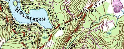


3 Copyright (C) 1997, Maptech, Inc. Fariview Farms
4 MITIGATION SITE FIELD DATA FORM Site Name: Fairview Farm Golf Course File No.: City/Town: Harwinton State: CT Waterbody: Monitor(s): Ruth Ladd, Paul Minkin Date: Was site constructed? yes Is site wetland? yes (some parts of Site 11 and Site 16 may lack hydrology) Size of proposed wetland: 1.13 acres enhancement Actual size of wetland: 1.24 acres creation, TBD Landscape position: mid-slope depressions Lat/Long Points: N , W Saved GPS Waypoint name: FF (+ hole #) GPS Tracking Log Name: N/A Perimeter: TBD Surrounding land use: Golf course Is wetland function compromised by surrounding land use? Yes Plant Health: Good, except for a few bare patches at Site 11 (due to regrading?) Invasive Species: Much Rosa multiflora; scant Phalaris arundinacea in Site 11 Wildlife Use:. Site 11 deer paths, many grasshoppers; small birds throughout Plants: Site 11: Alnus rugosa (on outer edges) Aster spp. Carex comosa Carex lurida Comptonia peregrina Cornus sp. Eupatorium perfoliatum Fragaria sp. Ilex verticillata Impatiens capensis Juncus effusus Mentha piperata Mimulus ringens Onoclea sensibilis Panicum sp. Phalaris arundinacea Plantago major Poaceae spp. Rosa multiflora Rubus hispidus Rubus sp. Salix spp. Scirpus cyperinus Solidago rugosa Solidago sp. Spiraea tomentosa Typha latifolia Viburnum dentatum Vitis sp. Site 15: Page 1 of 2 Aster spp. Carex comosa
5 Carex lurida Eupatorium perfoliatum Glyceria sp. Impatiens capensis Juncus effusus Lycopus sp. Mimulus ringens Polygonum sagittatum Rosa multiflora Salix spp. Scirpus cyperinus Scirpus microcarpus Solidago spp. Soils Data: Soils data not collected at this site. Sketch approximate mitigation site, noting areas and types of wetlands, waters, other features, landscape position, landmarks, etc., and data and photo point(s): See field notes Overall Description of site: Golf course with wetland mitigation located marginal to greens, tees, and fairways. Some partially adjacent to forested areas. Comments, problems, recommendations: Site 11: upslope areas of site wetter, standing water in spring Soil sandy loam, no topsoil, saturated to the surface; oxidized rhizospheres, redoxymorphic concentrations and depletions within the upper 6 inches Site 16: most of site dominated by Rosa multiflora and Solidago spp. and may not be wet; some low spots at the site; wet swale by drainpipe dominated by graminoids, silt fence still present here Site 7: just constructed, not planted; bluebirds, other small passerines, and chipmunk located in this open area Site 5: very small site, some Typha latifolia in pond, narrow scrub-shrub along margins Page 2 of 2
6
7
8
9
10
11
12
13
14
15
16 1.24 ac golf course yes no no 0 Fairview Farms Golf Course N W RL PM 10/15/02 PEM no no 0 high mitigation is scattered locations around golf course surrounded by golf course but very limited


17 Fairview Farm Golf Course Harwinton, CT 10/15/02 Hole 11 site looking north and east from southwest end Hole 15 looking south and southwest from north end Hole 16 looking east and south from west side


18 Hole 5 looking east and south from west side Hole 7 looking south from north end. It is newly completed; it had been omitted from the original construction.


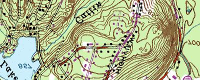
19 3 km S of Harwinton, Connecticut, United States 12 Apr 1991 Image courtesy of the U.S. Geological Survey 2003 Microsoft Corporation. All rights reserved.
CT EXPANSION PROJECT SILT FENCE DESIGN CRITERIA AND METHODOLOGY CONNECTICUT LOOP. Submitted by:..
 CT EXPANSION PROJECT SILT FENCE DESIGN CRITERIA AND METHODOLOGY CONNECTICUT LOOP Submitted by:.. Tennessee Gas Company L.L.C. 1001 Louisiana St, Suite 1000 Houston, TX 77002 July 2014 Revised March 2015
Wetlands and Water Resources Technical Report Tier 1 Environmental Impact Statement
 PPMS: 67587 PROJECT NO: 0081-961-111 PPMS: 67588 PROJECT NO: 0081-962-116 PPMS: 67589 PROJECT NO: 0081-968-123 Wetlands and Water Resources Technical Report Tier 1 Environmental Impact Statement This technical
Salmon River Initiative - Native Plant Assessment SLELO-PRISM Information Management
 St. Lawrence Eastern Lake Ontario Partnership for Regional Invasive Species Management Salmon River Initiative - Native Plant Assessment Information Management July 30-31, 2013 Figure 1: Panoramic view
Barnegat Bay-Friendly Golf Course Certification Program
 Barnegat Bay-Friendly Golf Course Certification Program Businesses for a Better Barnegat Bay Thank you for your interest in becoming a Certified, Barnegat Bay-Friendly Golf Course. This American Littoral
Styal Golf Course Accommodation Works Environmental Statement Non-Technical Summary 1007/6.15.2/169
 Styal Golf Course Accommodation Works Non-Technical Summary 1007/6.15.2/169 September 2013 Document Control Sheet Project Title: Styal Golf Course Report Title: Non Technical Summary Document No: 1032775.014.001
Creation of Fish and Wildlife Habitat on the Closed Salmon Harbour Mine in Minto, NB
 Creation of Fish and Wildlife Habitat on the Closed Salmon Harbour Mine in Minto, NB M. Coleman 1, R. Rutherford 2, RA Currie 3 1 NB Power 2 Thaumas Environmental Consultants Ltd 3 RA Currie Ltd. Location
Table 1. Physical Characteristics of Your Lake.
 The lake assessments are created in partnership with Hillsborough County and the Florida Center for Community Design and Research LAKE ASSESSMENT DOCUMENT White Trout Lake /8/98 Watershed: Sweetwater Creek
CITY OF MADISON PROPOSED PROJECT. Wingra Park Shoreline Repair
 CITY OF MADISON PROPOSED PROJECT Wingra Park Shoreline Repair Wingra Park Current Shoreline Wingra Shoreline Wingra Shoreline Wingra Shoreline Wingra Shoreline Wingra Shoreline Concrete Abutment + Wooden
Innsbrook Resort Golf Course
 Innsbrook Resort Golf Course YARDAGE GUIDE Depth: 36 yards 1par 4 Innsbrook Resort Golf Course is nationally recognized, having received a Four-Star Rating from Golf Digest, making our course the highest
City of Burnaby Environmental Review Committee (ERC) Guide for Applicants
 Guide for Applicants") City of Burnaby Environmental Review Committee (ERC) Guide for Applicants 2017-2018 This Guide summarizes the ERC process for project review including applications for a relaxation (variance) to the development
City of Burnaby Environmental Review Committee (ERC) Guide for Applicants 2017-2018 This Guide summarizes the ERC process for project review including applications for a relaxation (variance) to the development
1. THE ESSENCE OF DROUIN GOLF & COUNTRY CLUB
 1. THE ESSENCE OF DROUIN GOLF & COUNTRY CLUB Drouin is unique as it is the only 27 hole golf course in the Gippsland region. The course presents three differing layouts to members and visitors combining
Legend. Figure 1 Location Map McKelvey Woods Trail Project City of Maryland Heights St. Louis County, Missouri. Proposed Trail NORTH.
 Path: V:\St Louis Office\St Louis County\65679_McKelvey Woods Trail Extension_for Herleth\GIS\DataFiles\ArcDocs\Wetlands 2013\Report Maps\Figure1.mxd brichards 4/23/2013 Proposed Trail 0 0.5 1 2 Miles
Water Management Plan For The Blue Ocean Golf Club
 Water Management Plan For The Blue Ocean Golf Club A water management plan reviews current water management practices and identifies opportunities for improvement in water use efficiency/conservation for
COASTAL WETLAND SURVEY. Location: Sec. 35, 36 T. 13N R. 17W Quadrangle: Pt. Arena (7 1/2 min) Field Investigator: Gayle Dana Date of Survey : 2/22/78
 Field Investigator: Gayle Dana Date of Survey : 2/22/78") COASTAL WETLAND SURVEY Name of Area: Garcia River County : Mendocino Location: Sec. 35, 36 T. 13N R. 17W Quadrangle: Pt. Arena (7 1/2 min) Ownership : Private Field Investigator: Gayle Dana Date of Survey
COASTAL WETLAND SURVEY Name of Area: Garcia River County : Mendocino Location: Sec. 35, 36 T. 13N R. 17W Quadrangle: Pt. Arena (7 1/2 min) Ownership : Private Field Investigator: Gayle Dana Date of Survey
Friends of the Detroit River Habitat Restoration Project Update
 Friends of the Detroit River Habitat Restoration Project Update 11 Beneficial Use Impairments (BUIs) were originally identified to be associated with the Detroit River: 1. Restrictions on fish and wildlife
Hopewell Valley Community Stewardship Plan Friends of Hopewell Valley Open Space. Appendix 4. Eames Preserve
 Appendix 4. Eames Preserve Acreage: 75.9 Block and Lot: B30, L4 Ownership: FoHVOS (27.4%) and NJDEP (72.6%) Year(s) Purchased: 2004 Location & Access: The preserve is located on the north side of Harbourton
Chair, Cllr Maxine Smith, North Planning Applications Committee, The Highland Council Members, NPAC
 18 th June 2018 Chair, Cllr Maxine Smith, North Planning Applications Committee, The Highland Council Members, NPAC Dear Chair/Members 17/04601/FUL and 17/04404/FUL Coul Links Not Coul respectfully makes
Reams Road RCA Study. Board of County Commissioners Public Hearing
 Reams Road RCA Study Board of County Commissioners Public Hearing April 24, 2018 Presentation Overview Study Overview Existing Conditions Development of Alternatives Preferred Alternative Public Involvement
Soule Park Management Plan
 Soule Park Management Plan Freeport Conservation Commission Approved by Freeport Town Council, February 5, 2008 Table of Contents Page 1 Page 1 Page 1 Page 2 Page 3 Page 4 Page 6 Purpose of the Plan Overview
1. Indicate the number of employees and supervisors who will be working on the site. 5-10
 28068 Site Description continued - Describe the natural vegetation --- ground cover, trees, shrubs --- and any proposed changes. Describe the location of any estuarine, riparian, or wetlands and any noticeable
STATE OF ALASKA DEPARTMENT OF NATURAL RESOURCES DIVISION OF MINING, LAND AND WATER LAND USE PERMIT APPLICATION AS
 STATE OF ALASKA DEPARTMENT OF NATURAL RESOURCES DIVISION OF MINING, LAND AND WATER LAND USE PERMIT APPLICATION AS 38.05.850 Applicants must complete all sections of this application. In addition, applicants
Oklahoma Water Resources Board
 Oklahoma Water Resources Board Acknowledgements: Partnered with City of Tulsa EPA 319 funding used OSU SWFAL Goal: Reduce effect of nutrient in lake OWQS site specific criteria 0.0168 mg/l TP 0.100 Acknowledgements:
2014 Island Lake Survey June 13 th, 2014 Andrew Plauck District Fisheries Biologist Report Prepared 4 March 2015
 2014 Island Lake Survey June 13 th, 2014 Andrew Plauck District Fisheries Biologist Report Prepared 4 March 2015 BACKGROUND - A fish survey was requested due to a moderately severe winterkill in Island
The Kew Golf Club. Vegetation Management Plan
 The Kew Golf Club Vegetation Management Plan Report No. PLLC_481_02 Contents The Kew Golf Club Vegetation Management Plan 1.0 Introduction... 3 2.0 The Site... 4 3.0 The aims of the Vegetation Management
FLOOD PREVENTION 2018 AUGUST 2018
 FLOOD PREVENTION 2018 AUGUST 2018 DECEMBER 2016 THE MORNING OF THE 4 TH OF DECEMBER 2016, MARBELLA AROSE WITH TORRENTIAL RAIN ALERTS FORCASTING PRECIPITATIONS UP TO 100 LITERS/M2/DAY. UNFORTUNATELY FORCAST
OKANAGAN RIVER RESTORATION INITIATIVE - FAQ
 OKANAGAN RIVER RESTORATION INITIATIVE - FAQ Initiative background: The health of the q awsitk w (Okanagan River) has been severely impacted by the channelization works that occurred in the mid-1950 s.
USGA GREEN SECTION TURF ADVISORY SERVICE REPORT SEWICKLEY HEIGHTS GOLF CLUB Sewickley, Pennsylvania
 United States Golf Association Mid-Atlantic Region Green Section 1910 Cochran Road Manor Oak One, Suite 410 Pittsburgh, PA 15220 (412) 341-5922, FAX (412) 341-5954 USGA GREEN SECTION TURF ADVISORY SERVICE
EcoLogic Memorandum. TO: Ben Brezell; EDR FROM: Mark Arrigo RE: Possible Impacts of Dredging Snooks Pond DATE: 6/4/07
 EcoLogic Memorandum TO: Ben Brezell; EDR FROM: Mark Arrigo RE: Possible Impacts of Dredging Snooks Pond DATE: 6/4/07 Background EDR P.C. (EDR) has been contracted by a landowner to assess the feasibility
-SQA-SCOTTISH QUALIFICATIONS AUTHORITY. Hanover House 24 Douglas Street GLASGOW G2 7NQ NATIONAL CERTIFICATE MODULE DESCRIPTOR
 -SQA-SCOTTISH QUALIFICATIONS AUTHORITY Hanover House 24 Douglas Street GLASGOW G2 7NQ NATIONAL CERTIFICATE MODULE DESCRIPTOR -Module Number- 0088239 -Session-1988-89 -Superclass- -Title- SF TREES AND SHRUBS
Tips for Using & Printing Spreadsheets
 Key to Spreadsheets Spreadsheet # Type Description/Purpose a Development & Construction in Waterways b Debits Development & Construction in Other Aquatic Areas c Indirect Impacts to Waterways from Development
Moor Park Course Report. March 2019
 Moor Park Course Report March 2019 Divoting 01 The tees on both courses have recently been divoted as a general preseason exercise. Seed germination within these divots will start within the next 2-3 weeks.
VWP CONSTRUCTION INSPECTION REPORT. Project Name: Berkmar Drive Extension Locality: Albemarle County Inspector: ERM
 VWP CONSTRUCTION INSPECTION REPORT Inspection Date: August 22, 2016 VWP Permit No. 15-1268 SPGP RO Project Name: Berkmar Drive Extension Locality: Albemarle County Inspector: ERM Impacts: PFO PEM PSS POW
Audubon Cooperative Sanctuary Program for Golf Courses. Place Alternating Slideshow Photo Here
 Audubon Cooperative Sanctuary Program for Golf Courses Place Alternating Slideshow Photo Here Audubon Cooperative Sanctuary Program for Golf Courses In 1991, Audubon International, with the support of
Aquatic Plant Point-Intercept Survey for Cates Lake, Scott County, Minnesota
 American Lotus in Cates Lake, Scott County, Minnesota, 2016 Aquatic Plant Point-Intercept Survey for Cates Lake, Scott County, Minnesota [Plant Survey Conducted August 29, 2016] Prepared for: Prior Lake-Spring
18 HOLE RISK ASSESSMENT COMPLETED BY: MARK HAINES POSITION HELD: COURSE MANAGER DATE:
 18 HOLE RISK ASSESSMENT COMPLETED BY: MARK HAINES POSITION HELD: COURSE MANAGER DATE: 03.02.2017 REVIEW DATE: 03.02.2019 Hole No. Risk Description Grade of Risk Recommendations 1st Course access path on
Description of the Fields
 This vernal pool assessment form was developed through funds provided by the Environmental Protection Agency to establish a GIS user interface with the capability to not only integrate all of the vernal
Winter Drawdown Issues of Concern
 Winter Drawdown Issues of Concern Wetland Connectivity Amphibians Fisheries Winter Drawdown Wetland Connectivity Wetland complex near Osprey Creek is not responsive to lake level Wetland at upper end of
STATE AID FOR LOCAL TRANSPORTATION Rev. July 2010 De MINIMIS WRITE-UP FOR PM For parks, recreation areas, wildlife or waterfowl refuges Page 1 of 3
 SECTION 4(f) STATE AID FOR LOCAL TRANSPORTATION Rev. July 2010 For parks, recreation areas, wildlife or waterfowl refuges Page 1 of 3 The Safe, Accountable, Flexible, Efficient Transportation Equity Act:
MARLWOOD GOLF & COUNTRY CLUB WASAGA BEACH, ONTARIO
 MARLWOOD GOLF & COUNTRY CLUB WASAGA BEACH, ONTARIO Prepared for: Marlwood Golf & Country Club 445 Golf Course Road Wasaga Beach, Ontario L0L 2P0 Prepared by: MBTW Golf Design 255 Wicksteed Avenue Unit
Eastport Pitch and Putt
 1.0 NAME OF UNDERTAKING: Eastport Pitch and Putt 1.1 Proponent: Graham C. Feltham, Proprietor 22 Grieve Cres. Gander, NL A1V 1P3 Telephone: 709-651-2842 (home) e-mail: innbythesea@nf.sympatico.ca 709-677-3002
Triple C Ranch 486+/- Acres Upshur County, Texas $1,292,760 ($2660/acre)
") Office: (214) 361-9191 Triple C Ranch 486+/- Acres Upshur County, Texas $1,292,760 ($2660/acre) LOCATION: Triple C Ranch is located in the scenic hills of northwest Upshur County between Winnsboro, TX
Office: (214) 361-9191 Triple C Ranch 486+/- Acres Upshur County, Texas $1,292,760 ($2660/acre) LOCATION: Triple C Ranch is located in the scenic hills of northwest Upshur County between Winnsboro, TX
Information for File #MVP MVM
 Information for File #MVP-2018-00168-MVM Applicant: City of Lino Lakes Corps Contact: Marissa Merriman Address: 180 Fifth Street East, Suite 700, St. Paul, Minnesota 55101-1678 E-Mail: Marissa.V.Merriman@usace.army.mil
Importance of un-named tributary streams to Brook Trout populations. Dr. Jonathan M. Niles Dr. Dan Ressler
 Importance of un-named tributary streams to Brook Trout populations. Dr. Jonathan M. Niles Dr. Dan Ressler Pennsylvania Streams All streams of PA have a designated use - Huge resource - 8,011 named tributaries:
JAP Additional Information Sheet
 JAP Additional Information Sheet Block 15: Purpose and Need The USACE purpose of the project is to provide a safe and reliable whitewater park for the recreational public in a city park, which will provide
U.S. Fish & Wildlife Service West Virginia Field Office 694 Beverly Pike Elkins, WV. ATTN: Project Review Request
 December 6, 2016 VIA FEDEX U.S. Fish & Wildlife Service West Virginia Field Office 694 Beverly Pike Elkins, WV ATTN: Project Review Request Re: Rover Pipeline LLC, Rover Pipeline Project Threatened and
ADOPT-A-STREAM WATERSHED APPROACH COMMUNITY-BASED STEWARDSHIP. Nova Scotia Salmon Association March 2005
 ADOPT-A-STREAM A WATERSHED APPROACH TO COMMUNITY-BASED STEWARDSHIP Nova Scotia Salmon Association March 2005 This manual is a revised and updated version of the 1994 Adopt-a-Stream manual that was prepared
FACT SHEET MCGREGOR LAKE RESTORATION HABITAT PROJECT POOL 10, UPPER MISSISSIPPI RIVER, WISCONSIN ENVIRONMENTAL MANAGEMENT PROGRAM
 FACT SHEET MCGREGOR LAKE RESTORATION HABITAT PROJECT POOL 10, UPPER MISSISSIPPI RIVER, WISCONSIN ENVIRONMENTAL MANAGEMENT PROGRAM LOCATION McGregor Lake is located within a mid-river island in Pool 10
Annex L: Badger Survey Report
 Ashfield Land Management and Gazeley GLP Northampton s.à.r.l Annex L: Rail Central FEBRUARY 2018 1 RSK GENERAL NOTES Project No.: Title: Rail Central Client: Ashfield Land Management Limited and Gazeley
J FLY LOOSE RANCH ACRES LAVACA COUNTY, SPEAKS, TX. JEFF BOSWELL Partner/Broker REPUBLICRANCHES.
 J FLY LOOSE RANCH 984 + ACRES LAVACA COUNTY, SPEAKS, TX JEFF BOSWELL Partner/Broker 713-3048186 bos@republicranches.com REPUBLICRANCHES.COM J FLY LOOSE RANCH Likely one of the best hunting ranches located
Conservation and Restoration Florida s Coastal Marshes: An Overview of MESS. Jeff Beal, Kent Smith, Erin McDevitt, Maria Merrill
 Conservation and Restoration Florida s Coastal Marshes: An Overview of MESS Jeff Beal, Kent Smith, Erin McDevitt, Maria Merrill FWC s MESS: -Marine/Estuarine Subsection -within Aquatic Habitat Conservation
ARkAnsAs tennessee Primary Partner: Primary Partner: Habitat Work: Habitat Work:
 Eastern Elk initiative david STEPhENSON Elk in the East On foggy mornings when the chill of fall is in the air, distant elk bugles ring sparsely through the hills and valleys of the East. Each one tells
From the beginning, the property at West Fork was a
 From the beginning, the property at West Fork was a special piece of land. A combination of natural features that included trees, wetlands, streams, high hills and the West Fork of the San Jacinto River
Big Spring Creek Habitat Enhancement and Fishery Management Plans
 Big Spring Creek Habitat Enhancement and Fishery Management Plans November 5, 2012 Big Spring Events and Activities Center Newville, PA Charlie McGarrell Regional Habitat Biologist Pennsylvania Fish and
Mud Bay SLELO-PRISM Water Chestnut & Hydrilla Surveillance 2012
 St. Lawrence Eastern Lake Ontario Partnership for Regional Invasive Species Management Mud Bay Water Chestnut & Hydrilla Surveillance 2012 June 27 th (Water Chestnut) & August 2 (Hydrilla), 2012 Figure
4.7 Landscape Provisions.
 4.7. A. Intent. Landscaping of required Yards and required Bufferyards is an essential element of the design of a site with respect to promoting the public health, safety, comfort, convenience and general
3.0 Basin and Watershed Characteristics
 3.0 Basin and Watershed Characteristics 3.1 Basin Characteristics 3.1.1 Crystal Lake Crystal Lake, located in the cities of Burnsville and Lakeville (Dakota County), covers an area of approximately 292
VIMS CCRM Coastal Management Decision Tools. Decision Tree for Undefended Shorelines and Those with Failed Structures
 VIMS CCRM Coastal Management Decision Tools Decision Tree for Undefended Shorelines and Those with Failed Structures Center for Coastal Resources Management Virginia Institute of Marine Science Gloucester
Results from the 2012 Quail Action Plan Landowner Survey
 Results from the 2012 Quail Action Plan Landowner Survey By Andrew W Burnett New Jersey DEP Division of Fish & Wildlife Mail Code 501 03 PO Box 420 Trenton 08625 0420 Abstract: A survey was conducted in
FACT SHEET I. LOCATION
 STEAMBOAT ISLAND HABITAT REHABILITATION AND ENHANCEMENT PROJECT (HREP) SCOTT COUNTY, IOWA, UPPER MISSISSIPPI RIVER RESTORATION-ENVIRONMENTAL MANAGEMENT PROGRAM ROCK ISLAND DISTRICT FACT SHEET I. LOCATION
LaSalle Park Marina Wave Break
 LaSalle Park Marina Wave Break Federal and Municipal Environmental Assessment Background History of the Marina and LaSalle Park The LaSalle Park Marina is located in LaSalle Park at the foot of LaSalle
The Cove Run Brook Trout Restoration Project with the Northern Garrett High School AP Environmental Science Class,
 The Cove Run Brook Trout Restoration Project with the Northern Garrett High School AP Environmental Science Class, 2012 2014. Image or Graphic Presented By: Alan W. Klotz, Western Region District I, Inland
Annex B SUPPLEMENTAL INFORMATION. Table of Contents. Scientific Names of Select Plants and Animals. Fish species collected in Curwensville Lake
 Annex B SUPPLEMENTAL INFORMATION Table of Contents Scientific Names of Select Plants and Animals Fish species collected in Curwensville Lake Alternative Plans Percentage of Future Years with Drawdowns
Union Pacific Railroad
 Input Questions: 404/401 Pre Application Meeting, December 18, 2013, Portland, Oregon 1. What is the project purpose and need? The purpose of the project is to improve the efficiency and average velocity
The Sweatman Ranch 2800+/- Acres
 The Sweatman Ranch 2800+/- Acres For Additional Information Contact: 1330 FM 1069 Aransas & San Patricio County Summary The Sweatman Ranch is a 2800+/- game & fishing paradise located between Rockport
Great Lakes Stream Crossing Inventory Instructions
 Great Lakes Stream Crossing Inventory Instructions This document is a guide to completing the Stream Crossing Data Sheet (2/28/11 version). Careful attention to this guidance will ensure consistent crossing
Minnesota Department of Natural Resources Division of Fish and Wildlife Section of Fisheries. Stream Survey Report. Luxemburg Creek.
 Minnesota F-29-R(P)-24 Area 315 Study 3 March 2016 Minnesota Department of Natural Resources Division of Fish and Wildlife Section of Fisheries Stream Survey Report Luxemburg Creek 2015 Mark Pelham Sauk
Hopewell Valley Community Stewardship Plan Friends of Hopewell Valley Open Space. Appendix 14. Kulak and Lawrence Preserves
 Appendix 14. Kulak and Lawrence Preserves Acreage: 70.22 (Lawrence 13.84 acres, Kulak 56.38 acres) Block and Lot: Multiple. B4, L1.01 (Lawrence); B4, L16, 18, 41 (Kulak) Ownership: Lawrence - FoHVOS (100%);
DMU 361 Fremont Deer Management Unit Newaygo, Oceana, N. Muskegon Counties
 DMU 361 Fremont Deer Management Unit Newaygo, Oceana, N. Muskegon Counties Area Description The Fremont Deer Management Unit (DMU 361) was established in 2013. It lies within the Southwest Region and covers
Understanding Today s Environmental Issues and the Oregon Stewardship Guidelines. David Phipps GCSAA NW Field Staff
 Understanding Today s Environmental Issues and the Oregon Stewardship Guidelines David Phipps GCSAA NW Field Staff My Roots Northwest Landscape Industries 1986-1990 The Oregon Golf Club 1990-2000 Stone
Transforming Chadwick Lake
 Transforming Chadwick Lake Chadwick Lake has been going through a process of renovation over the past two years. Management of the area began with a vision statement of producing an ecosystem comprised
Coastal management has lagged behind the growth in population leading to problems with pollution
 Fifty percent of the population of the industrialized world lives within 100 km of a coast. Coastal management has lagged behind the growth in population leading to problems with pollution and natural
COOKE COUNTY APPRAISAL DISTRICT WILDLIFE MANAGEMENT INFORMATION
 COOKE COUNTY APPRAISAL DISTRICT WILDLIFE MANAGEMENT INFORMATION CONTENTS: Wildlife Management Defined.................................... 2 Qualifications..................................................
Columbia Lake Dam Removal Project
 Columbia Lake Dam Removal Project The Columbia Lake dam located 1/4 mile upstream of the Paulins Kill River's confluence with the Delaware River in Knowlton Township, Warren County has been proposed for
Wildlife Hazard Mitigation Policy, Plan and Procedure. May
 Wildlife Hazard Mitigation Policy, Plan and Procedure May - 2010 I. POLICY: The Wildlife Hazard Mitigation Plan will identify both short and long term strategies for mitigating the hazard that certain
Golf Course. Final Report & Recommendations to the HPCA Board. December 2016 HPCA LONG RANGE PLANNING COMMITTEE REPORT
 Golf Course Task Force Final Report & Recommendations to the HPCA Board December 2016 HPCA LONG RANGE PLANNING COMMITTEE REPORT HPCA LONG RANGE PLANNING COMMITTEE GOLF COURSE TASK FORCE Statement of Purpose
G7 Ranches, LLC. Proud Affiliate of Coldwell Banker Select Offices conveniently located in Tulsa, Oklahoma City, Durant
 The Synar Brothers Ranch offers an opportunity to mix good grass with recreation. The ranch has exceptional hay meadows with an abundance of wildlife for the avid hunter. This Ranch is comprised of 1,653
PRELIMINARY STORM DRAINAGE REPORT
 PRELIMINARY STORM DRAINAGE REPORT DRURY LANE DEVELOPMENT 704 1ST STREET SULTAN, WA 98294-94240 PARCEL #28083200305500 AUDITOR S FILE NO. 1090255 CITY OF SULTAN SNOHOMISH COUNTY, WASHINGTON PREPARED FOR:
The Blue Heron Slough Conservation Bank
 1 The Blue Heron Slough Conservation Bank CONSERVATION BANKING July 19-23, 2010 CASE STUDY SERIES The Blue Heron Slough Conservation Bank (Washington) I. OVERVIEW & BACKGROUND: Location: Snohomish River
Shimmerhorn Ranch. Buford, Wyoming // Albany County
 Shimmerhorn Ranch Buford, Wyoming // Albany County The Shimmerhorn Ranch is located just off Interstate 80; it lies 20 miles east of Laramie, the home of the University of Wyoming, and 30 miles west of
Walks in Chellow Dene
 City of Bradford Metropolitan District Council Leisure Services a breath of fresh air Walks in Chellow Dene In association with the Fairweather Green and Daisy Hill Action groups Chellow Dene Chellow Dene
Completing the Puzzle: Conserving the Florida Keys Ecosystem One Parcel At a Time
 2007 Public Land Acquisition & Management Partnership Conference Completing the Puzzle: Conserving the Florida Keys Ecosystem One Parcel At a Time Anne Morkill Florida Keys National Wildlife Refuges Complex
TOWN OF GUILFORD 31 Park Street GUILFORD, CONNECTICUT SETTLED IN 1639
 TOWN OF GUILFORD 31 Park Street GUILFORD, CONNECTICUT 06437 www.ci.guilford.ct.us SETTLED IN 1639 TELEPHONE (203)453-8015 FAX (203)453-8467 EAST RIVER PRESERVE DEER STUDY COMMITTEE DRAFT MEETING MINUTES
Cincinnati Parks Wildlife Management Report
 Cincinnati Parks Wildlife Management Report Cincinnati Parks has been managing the deer herd in select parks for 7 years. During that time we have had new members join our Board, new City Council members,
River Restoration: Culvers Island weir removals and river naturalisation project.
 River Restoration: Culvers Island weir removals and river naturalisation project. Background Chalk streams are an incredibly rare habitat on a global scale, and owing to their international importance,
MnDOT Standard Native Seed Mixture Designations
 33-261 Stormwater Treatment Basins South & West big bluestem Andropogon gerardii 2.24 2.00 5.72% 7.35 fringed brome Bromus ciliatus 2.24 2.00 5.73% 8.10 bluejoint Calamagrostis canadensis 0.07 0.06 0.18%
DELAWARE WILDLIFE JUDGING LEADER S GUIDE 2018
 DELAWARE WILDLIFE JUDGING LEADER S GUIDE 2018 The 4-H Wildlife Habitat Judging Contest is an event designed to teach youth the fundamentals of wildlife management. Although it is a competitive event, its
Bang 57 Ranch. Okeechobee, Florida 277 +/- Acres. Family Retreat Corporate Retreat Hunting & Recreational Property
 Bang 57 Ranch Okeechobee, Florida 277 +/- Acres Family Retreat Corporate Retreat Hunting & Recreational Property Coldwell Banker Commercial Saunders Real Estate 114 North Tennessee Avenue, 3rd Floor, Lakeland,
RI Regulatory Setbacks & Buffers: Coastal Management Issues
 RI Regulatory Setbacks & Buffers: Coastal Management Issues New England Onsite Wastewater Training Program @ URI OWT 155 - November 29, 2012 James Boyd - Coastal Policy Analyst Photo: October 30, 2012
GEO Certified Independent Verification Report
 Golf Facility: Hørsholm Golf Prepared by: Ole Riger-Kusk Date: October 2017 Executive Summary Hørsholm Golf is located approx. 20 km north of Copenhagen. The first 9 holes were established in 1992 at the
DMU 056 Midland County Deer Management Unit
 DMU 056 Midland County Deer Management Unit Area Description The Midland County Deer Management Unit (DMU) 056 is in the Northern Lower Peninsula (NLP) Region. It has roughly 333, 440 acres and consists
Survey Style - Borders
 Style - Borders 0.25 Point 0.50 Point 1.00 Point 1.50 Point 2.00 Point 2.50 Point 3.00 Point 3.50 Point Double Line Located in: ArcGIS\Bin\Styles\.style Version: ArcGIS 9.0 1 Style - Colors Bedrock 1 Elevation
6.7 Aircraft Protection
 Schedules to Decision 377 6.7 Aircraft Protection 6.7.1 Introduction This introduction is to assist the lay reader to understand how this sub-chapter works and what it applies to. It is not an aid to interpretation
Conservation Commission Meeting Sharon Community Center April 27, DRAFT
 Sharon Community Center - DRAFT Peg Arguimbau, Chair, Meredith, Avery, Jon Wasserman, Michael Donatelle and Alan Westman were the members present. Members not present included Keevin Geller and Stephen
Habitat Development: Habitat Boulders Lawson Pier Foreshore Enhancement
 Habitat Development: Habitat Boulders Improve the existing habitat by stabilising beach sediments. Increase biodiversity by creating new habitats and colonisation opportunities. Loose cobble is unstable;
Level II Stream Survey for the Timberline Express Proposal
 TECHNICAL MEMORANDUM 24 146th Place SE Suite 6 Bellevue WA 987 Tel: 42.6.69 Fax: 42.6.694 www.segrp.com TO: FROM: CC: Bill Granger Travis Spikes Timberline Express EIS project folder DATE: October 21,
Penobscot River Shoreline Survey and Assessment
 Penobscot River Shoreline Survey and Assessment January 4, 2008 PREPARED FOR: Penobscot River Restoration Trust c/o Kleinschmidt Associates PO Box 650; 141 Main Street Pittsfield, ME 04967 PREPARED BY:
Golf Course Water Use Survey Timmothy Gergeni and Karen Panter Department of Plant Sciences, University of Wyoming November 22, 2013
 Golf Course Water Use Survey Timmothy Gergeni and Karen Panter Department of Plant Sciences, University of Wyoming November 22, 2013 As reported by the 115 respondents, the largest percentage of the golf
Groton Open Space Association s AVERY FARM EXPLORER GUIDEBOOK
 Groton Open Space Association s AVERY FARM EXPLORER GUIDEBOOK AVERY FARM DESCRIPTION: Called one of the most biologically diverse and valuable conservation sites in eastern Connecticut, this beautiful,
APPENDIX 11 WIND EFFECTS ASSESSMENT
 APPENDIX 11 WIND EFFECTS ASSESSMENT Summerset Villages (Lower Hutt) Ltd District Plan Change Request Prepared by Urban Perspectives Ltd 17 September 2014 341 49 342 Opus Research Report 14-529D84.00 Wind
Endangered Cactus Role-Playing Debate May, The Proposed Action
 Endangered Cactus Role-Playing Debate May, 2003 The Proposed Action KB Homes, a major housing development corporation in southern Arizona, wishes to build a new housing project at the intersection of Alvernon