CITY OF MADISON PROPOSED PROJECT. Wingra Park Shoreline Repair
|
|
|
- Ambrose Willis
- 5 years ago
- Views:
Transcription


1 CITY OF MADISON PROPOSED PROJECT Wingra Park Shoreline Repair
2 Wingra Park Current Shoreline
3 Wingra Shoreline
4 Wingra Shoreline
5 Wingra Shoreline
6 Wingra Shoreline
7 Wingra Shoreline Concrete Abutment + Wooden Pier
8 Wingra Shoreline Concrete Abutment + Wooden Pier
9 Wingra Shoreline
10 Wingra Shoreline
11 Wingra Shoreline
12 Wingra Shoreline
13 Wingra Shoreline


14 Wingra Shoreline Plan View
15 Wingra Low Energy Shoreline Wave energy low Different from Mendota/Monona Smaller, shallower lake Short fetch (small waves) Cannot hard armor shoreline (per DNR) Limits riprap use
16 Types of Shoreline Stabilization Soft-armor bioengineering-plant materials into structures that are designed to withstand wave and ice action Appropriate where plants can grow Root structures naturally stabilize the shoreline Rock riprap-common hard-armor technique which consists of large rocks placed in the water and up along the shoreline Lined with geotextile fabric to prevent wave action from removing soil from behind rocks, causing slumping Erosion control fabrics-useful on slopes for holding soil in place until plants establish from seed Geotextile fabrics-made of densely woven material that can withstand intense wave energy when placed under rock riprap
17 Lake Access Design Considerations Met with key park users throughout design process Friends of Lake Wingra, Wingra Boats, UW Rowing, Logrollers Equitable, sustainable opportunity for water access for multiple purposes Signature design that provides opportunities to interact with the shoreline as well as: Reduce maintenance and capitol costs Provide shoreline protection from wave and ice damage Can be permitted through the Wisconsin DNR and Army Corp of Engineers permitting process Aesthetic integration into the shoreline
18 Proposed Shoreline Changes Encapsulated Soil Lifts Rock Riprap Limestone Step Lake Access New Dock Moving location of UW Boating Pier Adding small canoe/kayak launch
19 Wingra Shoreline Design Layout
20 Riprap Rendering to Scale
21 Other Similar Projects: Riprap on the Yahara River


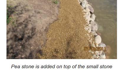
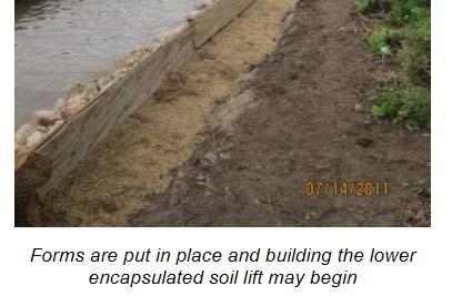
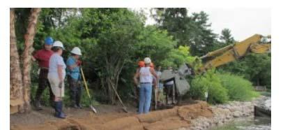
22 Other Similar Projects: Riprap on the Yahara River
23 Proposed Riprap Location

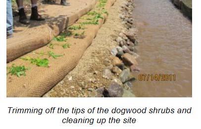
24 Limestone Steps Rendering to Scale
25 Other Similar Projects: Limestone Steps on the Yahara River
26 Other Similar Projects: Limestone Steps being built Lake Monona
27 Other Similar Projects: Limestone Steps Ester Park Lake Monona
28 Proposed Limestone Step Location
29 Encapsulated Soil Lifts Rendering to Scale


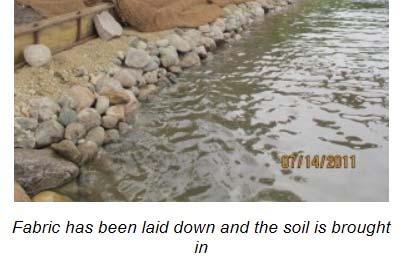
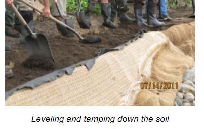
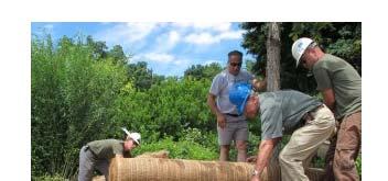
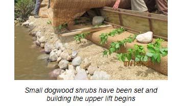
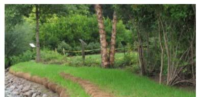
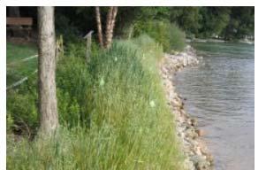
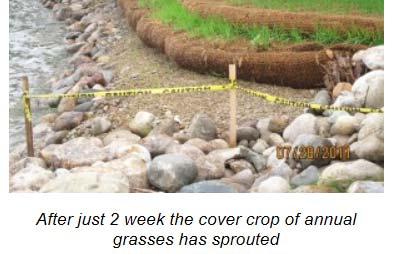
30 Encapsulated Soil Lifts Goals Reduce erosion into lake Aesthetically pleasing, natural Process Encapsulation of soil in biodegradable blankets formed into layers The layers, or lifts, are stacked up on the bank, stepped back to create the desired slope Seeded and planted with natives

31 Encapsulated Soil Lifts
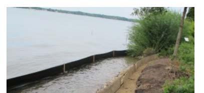
32 Encapsulated Soil Lifts

33 Encapsulated Soil Lifts

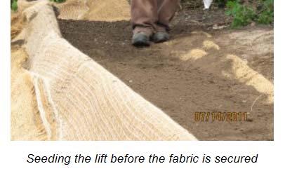
34 Encapsulated Soil Lifts
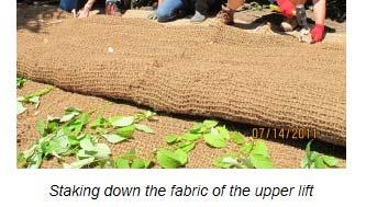
35 Encapsulated Soil Lifts
36 Encapsulated Soil Lifts


37 Encapsulated Soil Lifts
38 Proposed Encapsulated Soil Lift Locations


39 Proposed Native Sedges and Forbs Low perennials and sedges with a height <3 Tolerant of fluctuating water and long duration under water Planting species to be determined based on elevation from ordinary high water mark


40 Proposed Native Sedges and Forbs Example Plants: Iris versicolor Blue Flag Iris Lobelia cardinalis Cardinal Flower Saggittaria latifolia Arrowhead Carex stipata Awl fruited Sedge Carex comosa Bottlebrush Sedge Carex molesta Field Oval Sedge Carex vulpinoidea Brown Fox Sedge Scirpus atrivirens Dark Green Bulrush Polygonum amphibium Water Smartweed Alisma trivale Water Plantain Juncus effusus Common rush
41 Proposed Shoreline Changes 1:1 riprap for log rollers Bumping out all features to protect trees 1 maple deemed unhealthy by forestry Will be replaced in similar area Replacing wooden deck Moving UW Women s Rowing dock Small canoe/kayak launch Resetting corner of stone wall at boat ramp
42 Wingra Park Concrete Abutment + Wooden Pier
43 Wingra Shoreline

44 Other Shoreline Details
45 Anticipated Timeline Permitting - fall/winter 2017 Construction - early spring 2018 or late fall 2018
46 COMMENTS OR QUESTIONS? Contact Information: Jojo O Brien JOBrien@cityofmadison.com
47 Citations
48 MSU ESL Detail
Natural Shoreline Restoration for High Energy Shorelines. Brian Majka Restoration Ecologist 3/7/2019
 Natural Shoreline Restoration for High Energy Shorelines Brian Majka Restoration Ecologist 3/7/2019 Today we ll discuss: High energy shorelines Restoration techniques for high energy shorelines Project
U.S. Army Corps of Engineers
 A. U.S. Army Corps of Engineers Kevin Parsons, Natural Resources Specialist 500 Resource Management Drive West Point, GA 31833 706-645-2937 Kevin.M.Parsons@usace.army.mil B. Underwater Structure Enhancement
RLRC COMMUNITIES EAST GRAND FORKS AREA CHARACTER THE RED LAKE RIVER & THE RED RIVER OF THE NORTH CONFLUENCE EAGLE POINT BOAT LAUNCH DESIGN
 AREA CHARACTER THE RED LAKE RIVER & THE RED RIVER OF THE NORTH CONFLUENCE EAGLE POINT BOAT LAUNCH DESIGN DESIGN DETAILS 135 AREA CHARACTER East Grand Forks a city of 7,501 people is located across the
PRACTICE STANDARDS AND NR 328. Choosing a Technique and Getting a Permit
 PRACTICE STANDARDS AND NR 328 Choosing a Technique and Getting a Permit CHOOSING A TECHNIQUE Define cause of erosion Upland runoff? Impervious areas? Velocities? Wave energies? Boat or wind generated?
JAP Additional Information Sheet
 JAP Additional Information Sheet Block 15: Purpose and Need The USACE purpose of the project is to provide a safe and reliable whitewater park for the recreational public in a city park, which will provide
Water Resources Report RKLD Annual Meeting July 30, 2016
 Water Resources Report RKLD Annual Meeting 2016 July 30, 2016 Topics Hydrology Report Indianford Dam trash rack cleanout performance Experimental Project update Review of PAS project Twin floods- 1 to
Richard W. Gilbert, P.E.
 Nutten Hook Shoreline Stabilization Assessment Town of Stuyvesant, NY June 16, 2015 Prepared for: Hudson River National Estuarine Research Reserve NYS Department of Environmental Conservation 259 Norrie
Shoreline Erosion Control Failures and How To Avoid Them
 2008 Illinois Lake Management Association Shoreline Erosion Control Failures and How To Avoid Them by: Hank Sutton, President, Lake Rip Rap, Inc. www.lakeriprap.com - www.macoupinboats.com Setting the
REVETMENTS. Purposes and Operational Constraints. Purposes Erosion control o o. Revetment Design 4/5/2016. CE A676 Coastal Engineering
 REVETMENTS Ijsseldam, the Netherlands Orson P. Smith, PE, Ph.D. Instructor Purposes and Operational Constraints Purposes Erosion control o o Embankment Toe protection for a seawall, retaining wall or other
(Revised February,2005) CULVERTS, BRIDGES, AND FORDS
 CULVERTS, BRIDGES, AND FORDS") GUIDE TO STREAM CROSSINGS (Revised February,2005) CULVERTS, BRIDGES, AND FORDS Culverts, bridges, and fords are all methods used to cross-streams. Culverts are the most common stream crossing structure.
GUIDE TO STREAM CROSSINGS (Revised February,2005) CULVERTS, BRIDGES, AND FORDS Culverts, bridges, and fords are all methods used to cross-streams. Culverts are the most common stream crossing structure.
Canoe/Kayak Launch Sites and Accessibility
 Canoe/Kayak Launch Sites and Accessibility Doug Alderson, Paddling Trails Coordinator Division of Recreation and Parks Office of Greenways and Trails Each potential access site on a river, lake or ocean
Oklahoma Water Resources Board
 Oklahoma Water Resources Board Acknowledgements: Partnered with City of Tulsa EPA 319 funding used OSU SWFAL Goal: Reduce effect of nutrient in lake OWQS site specific criteria 0.0168 mg/l TP 0.100 Acknowledgements:
Erosion Control for Wisconsin s Inland Lakes and Flowages
 Erosion Control for Wisconsin s Inland Lakes and Flowages Wind Generated Waves wind Hs wave height (wave energy) Hs = function (1) wind speed U 10 (2) fetch [size of lake], X (3) water depth, d Wave
UNDERWATER BRIDGE INSPECTION REPORT STRUCTURE NO CSAH NO. 7 OVER THE SNAKE RIVER DISTRICT 1 - PINE COUNTY
 UNDERWATER BRIDGE INSPECTION REPORT STRUCTURE NO. 58506 CSAH NO. 7 OVER THE SNAKE RIVER DISTRICT 1 - PINE COUNTY PREPARED FOR THE MINNESOTA DEPARTMENT OF TRANSPORTATION BY COLLINS ENGINEERS, INC. JOB NO.
Choosing a Technique and Getting a Permit
 Choosing a Technique and Getting a Permit Choosing a Technique Define cause of erosion Upland runoff? Impervious areas? Velocities? Wave energies? Boat or wind generated? Ice action? Prevailing wind direction?
HARBOR INFRASTRUCTURE INVENTORIES Port Sanilac Harbor, Michigan
 HARBOR INFRASTRUCTURE INVENTORIES Port Sanilac Harbor, Michigan Harbor Location: Port Sanilac Harbor is located on the west shore of Lake Huron, about 30 miles north of Port Huron, MI. Authority: Rivers
Shoreline Studies Program, Department of Physical Sciences, VIMS
 Living Shoreline Training Class 2017 1 Demonstration sites discussed in this talk. 2 A shoreline management plan for the entire creek made conceptual shoreline management recommendations along every stretch
Estuarine Shoreline Stabilization
 Estuarine Shoreline Stabilization Property Owner s Guide to Determining the Most Appropriate Stabilization Method Estuarine shorelines are dynamic features that experience continued erosion. Land is lost
ALTERNATIVE SHORELINE TREATMENT GUIDELINE
 ALTERNATIVE SHORELINE TREATMENT GUIDELINE Prepared By: Galveston Bay Foundation 17324-A Highway 3 Webster, TX 77598 281-332-3381 www.galvbay.org May 9, 2003 17324-A Highway 3, Webster, TX 77598 Phone 281-332-3381
VIMS CCRM Coastal Management Decision Tools. Decision Tree for Undefended Shorelines and Those with Failed Structures
 VIMS CCRM Coastal Management Decision Tools Decision Tree for Undefended Shorelines and Those with Failed Structures Center for Coastal Resources Management Virginia Institute of Marine Science Gloucester
Hope Mills Lake Recreational Improvement Plan. Lake Advisory Committee
 Hope Mills Lake Recreational Improvement Plan Phase I Phase II Phase III This Phase is the time period prior to impoundment of the Lake. These items must be accomplished prior to the Lake level rising
Stevens Creek Corridor
 O F F I C E O F T H E D I R E C T O R O F P U B L I C W O R K S Stevens Creek Corridor Creek Restoration Project Volume Three Project Update: Creek Photos, Before & After BY GAIL SEEDS - PROJECT MANAGER,
HARBOR INFRASTRUCTURE INVENTORIES Marquette Harbor, Michigan
 HARBOR INFRASTRUCTURE INVENTORIES Marquette Harbor, Michigan Harbor Location: Marquette Harbor is located in Marquette Bay on the south shore of Lake Superior, 160 miles west of Sault Ste. Marie, MI and
4/20/17. #32 - Coastal Erosion Case Histories - Lake Michigan
 Writing Assignment Due Monday by 11:59 pm #32 - Coastal Erosion Case Histories - Lake Michigan See main class web pages for detailed instructions Submit papers Illinois Compass No copying: Compass will
natural low-water ' conditionson tamed Mississippi, new life springs, up Vl ' V ' ' - "
 When an experiment mimics natural low-water ' conditionson tjhe tamed Mississippi, new life springs, up in the \ backwaters. Vl ' V ' ' - " y *.»* ' ' ' - ' ' by JASON ABRAHAM Common map turtle Mississippi
UNDERWATER BRIDGE INSPECTION REPORT DISTRICT 1 PINE COUNTY
 UNDERWATER BRIDGE INSPECTION REPORT STRUCTURE NO. 58551 CSAH NO. 41 OVER THE KETTLE RIVER DISTRICT 1 PINE COUNTY JULY 28, 2012 PREPARED FOR THE MINNESOTA DEPARTMENT OF TRANSPORTATION BY COLLINS ENGINEERS,
La Quinta Channel Extension Port of Corpus Christi Ingleside, Texas. Mark Coyle
 La Quinta Channel Extension Port of Corpus Christi Ingleside, Texas Mark Coyle Corpus Christi Navigation Channel PCCA La Quinta Expansion Project History Corpus Christi Ship Channel Improvement Projects
HARBOR INFRASTRUCTURE INVENTORIES West Harbor, OH
 HARBOR INFRASTRUCTURE INVENTORIES West Harbor, OH Harbor Location: West Harbor is located on the southern shore of Lake Erie in the township of Catawba Island, OH about 50 miles east of Toledo, OH. Authority:
UNDERWATER BRIDGE INSPECTION REPORT STRUCTURE NO B WABASHA STREET SOUTH BOUND (MASA 235 SB)
") UNDERWATER BRIDGE INSPECTION REPORT STRUCTURE NO. 62555B WABASHA STREET SOUTH BOUND (MASA 235 SB) OVER THE MISSISSIPPI RIVER CITY OF ST. PAUL OCTOBER 31, 2012 PREPARED FOR THE MINNESOTA DEPARTMENT OF TRANSPORTATION
UNDERWATER BRIDGE INSPECTION REPORT STRUCTURE NO. 62555B WABASHA STREET SOUTH BOUND (MASA 235 SB) OVER THE MISSISSIPPI RIVER CITY OF ST. PAUL OCTOBER 31, 2012 PREPARED FOR THE MINNESOTA DEPARTMENT OF TRANSPORTATION
Building Coastal Resiliency at Plymouth Long Beach
 Building Coastal Resiliency at Plymouth Long Beach Department of Marine and Environmental Affairs March 30, 2017 Introducing Green Infrastructure for Coastal Resiliency Plymouth Long Beach & Warren s Cove
10/20/2010 Version 3. Guidelines for Developing Non-motorized Boat Launches in Florida
 Guidelines for Developing Non-motorized Boat Launches in Florida 1 These guidelines were prepared by the Florida Fish and Wildlife Conservation Commission with input from a Non-motorized Boating (NMB)
Ketchikan Harbors Thomas Basin and Bar Point Harbor
 Ketchikan Harbors Thomas Basin and Bar Point Harbor Condition of Improvements 30 December 2014 Thomas Basin & Bar Point Harbors Ketchikan, Alaska (CWIS No. 000631 & 087071) Authorization (1) Rivers and
Annex E Bridge Pier Protection Plan
 Annex E Bridge Pier Protection Plan Table E1 Bridge Types and Locations Table E2 Flow Conditions For River Sections Figure E1 Bridge Abutment Protection Figure E2 Bridge Pier Protection Figure E3 Central
29 National Estuarine Research Reserves
 Estuarine habitat is where it's at! Living Shorelines for Erosion Control Whitney Jenkins North Carolina Coastal Reserve & National Estuarine Research Reserve Division of Coastal Management 29 National
OECS Regional Engineering Workshop September 29 October 3, 2014
 B E A C H E S. M A R I N A S. D E S I G N. C O N S T R U C T I O N. OECS Regional Engineering Workshop September 29 October 3, 2014 Coastal Erosion and Sea Defense: Introduction to Coastal/Marine Structures
Estimated on-the-ground start and end dates: 1 June October 2018
 A. Applicant Information Name of Organization: U.S. Army Corps of Engineers, Carlyle Lake 801 Lake Road, Carlyle, IL 62231 Contact Information: Robert Wilkins, Operations Manager, (618) 594-2484, Robert.Wilkins@usace.army.mil
Cat Island Chain Restoration
 Cat Island Chain Restoration 1820s Fox River Military Road Map to Fort Howard 1845 Chart of Green Bay & Fox River Cat Island Chain - 1938 Cat Island Brown County Aerial Photography, 1938 Historic Western
Earthen Embankments. turning into larger, more costly repairs. The following. The State Dam Safety Program has inspection
 TOPIC: COMMON PROBLEMS FOR SMALL DAMS WITH CONCRETE CHANNEL SPILLWAYS The State Dam Safety Program has inspection requirements for state regulated dams. A dam, like any man-made structure, will change
TO: FROM: Y.102/MIN
 TO: FROM: Hastings-on-Hudson Shoreline Committee Amanda Ludlow and Kathryn Sommo, Roux Associates, Inc. DATE: March 13, 2017 RE: Meeting with NYSDEC Region 3 Hastings-on-Hudson Conceptual Shoreline Plans
Transforming Chadwick Lake
 Transforming Chadwick Lake Chadwick Lake has been going through a process of renovation over the past two years. Management of the area began with a vision statement of producing an ecosystem comprised
U.S. Army Corps of Engineers (USACE) P.O. Box 428 Smithville, MO
 P.O. Box 428 Smithville, MO") Applicant Information United States Army Corps of Engineers Kansas City District Principal Contact: Derek Dorsey, Natural Resource Manager U.S. Army Corps of Engineers P.O. Box 428 Smithville, MO 64089
Applicant Information United States Army Corps of Engineers Kansas City District Principal Contact: Derek Dorsey, Natural Resource Manager U.S. Army Corps of Engineers P.O. Box 428 Smithville, MO 64089
MILE POINT TRAINING WALL JACKSONVILLE, FL. Geotextile Tube Installation
 MILE POINT TRAINING WALL JACKSONVILLE, FL Geotextile Tube Installation PROJECT DESIGN Remove portion of existing training wall Construct new eastern and western training walls Deepen new flow improvement
REVISED SILT CURTAIN DEPLOYMENT PLAN
 Contract No.: HY/2009/11 Central Wanchai Bypass, North Point Reclamation REVISED SILT CURTAIN DEPLOYMENT PLAN Name Prepared by: China Harbour Engineering Co., Ltd. China Road and Bridge Corporation Joint
City of Madison, East Johnson Street North Baldwin Street to First Street Local Street Dane County
 City of Madison, East Johnson Street North Baldwin Street to First Street Local Street Dane County Public Involvement Meeting Thursday, November 10, 2016 5:30 to 7 P.M. Festival Foods 810 E. Washington
HARBOR INFRASTRUCTURE INVENTORIES Fairport Harbor, OH
 HARBOR INFRASTRUCTURE INVENTORIES Fairport Harbor, OH Harbor Location: Fairport Harbor is located at the mouth of the Grand River on the southern shore of Lake Erie in the city of Fairport, OH, approximately
FACT SHEET MCGREGOR LAKE RESTORATION HABITAT PROJECT POOL 10, UPPER MISSISSIPPI RIVER, WISCONSIN ENVIRONMENTAL MANAGEMENT PROGRAM
 FACT SHEET MCGREGOR LAKE RESTORATION HABITAT PROJECT POOL 10, UPPER MISSISSIPPI RIVER, WISCONSIN ENVIRONMENTAL MANAGEMENT PROGRAM LOCATION McGregor Lake is located within a mid-river island in Pool 10
Tracy E. Skrabal. October 2, 2012
 Tracy E. Skrabal October 2, 2012 Jurisdiction Living Shorelines/Sills Timeline for Permit Bulkhead/Revetments North Atlantic Division New England Division suspended all nationwide permits March 20, 2012
APPENDIX C VEGETATED EMERGENCY SPILLWAY. VERSION 1.0 March 1, 2011
 APPENDIX C VEGETATED EMERGENCY SPILLWAY VERSION 1.0 March 1, 2011 [NOTE: Could use a better photo more clearly showing the emergency spillway in the context of the dam.] SECTION C-1: DESCRIPTION OF PRACTICE
Riverbank Stabilization Inventory
 Riverbank Stabilization Inventory FINAL Prepared by: Shallan Dawson, Rebecca Stevens Bob Flagor, & Michael Schlepp Kootenai-Shoshone Soil and Water Conservation District 7830 Meadowlark Way, Ste. C-1 Coeur
For more information or permission to reprint slides, please contact Donna Milligan at 1
 For more information or permission to reprint slides, please contact Donna Milligan at milligan@vims.edu 1 For more information or permission to reprint slides, please contact Donna Milligan at milligan@vims.edu
Fairview Farms Golf Course
 File No.: 199701530 City and State: Harwinton, CT General Impacts: 1.37 acres PEM 0.82 acre PSS and PFO Fairview Farms Golf Course Functions and Values Lost: (From EA/SOF) Wildlife Habitat Year(s) Mitigation
GLOBAL CORAL REEF ALLIANCE A non-profit organization for protection and sustainable management of coral reefs
 GLOBAL CORAL REEF ALLIANCE A non-profit organization for protection and sustainable management of coral reefs Global Coral Reef Alliance, 37 Pleasant Street, Cambridge, MA 02139, USA Telephone: 617-864-4226
PREPARE TO LAUNCH! DESIRED LAUNCH CHARACTERISTICS Updated April User Accessibility. Site Location Appropriateness
 DESIRED LAUNCH CHARACTERISTICS Updated April 2018 User Accessibility Site Location Appropriateness Cost Considerations / Trade-offs Environmentallyfriendly There are four primary questions to answer in
Habitat Development: Habitat Boulders Lawson Pier Foreshore Enhancement
 Habitat Development: Habitat Boulders Improve the existing habitat by stabilising beach sediments. Increase biodiversity by creating new habitats and colonisation opportunities. Loose cobble is unstable;
CLAIBORNE LOCK AND DAM PERTINENT DATA
 CLAIBORNE LOCK AND DAM PERTINENT DATA GENERAL Location Clarke, Monroe, & Wilcox Counties, Alabama; Alabama River, river mile 72.5 Drainage area Millers Ferry to Claiborne sq. mi. 836 Total drainage area
As temporary grade control facilities along waterways until final stabilization is established.
 Check Dams (CD) EC-12 Description Check dams are temporary grade control structures placed in drainage channels to limit the erosivity of stormwater by reducing flow velocity. Check dams are typically
FACT SHEET I. LOCATION
 STEAMBOAT ISLAND HABITAT REHABILITATION AND ENHANCEMENT PROJECT (HREP) SCOTT COUNTY, IOWA, UPPER MISSISSIPPI RIVER RESTORATION-ENVIRONMENTAL MANAGEMENT PROGRAM ROCK ISLAND DISTRICT FACT SHEET I. LOCATION
CHAPTER 6 10/29/2018 Clean Version REGULATING PIERS, WHARVES, MOORING BUOYS, SWIMMING RAFTS AND INFLATABLES ON ROCK LAKE
 1 2 3 4 5 6 7 8 9 10 11 12 13 14 15 16 17 18 19 20 21 22 23 24 25 26 27 28 29 30 31 32 33 34 35 36 37 38 39 40 41 42 43 44 45 46 CHAPTER 6 10/29/2018 Clean Version REGULATING PIERS, WHARVES, MOORING BUOYS,
Portage Bay Park Design Commission Review 4: 90% Design Development January 5, 2017
 to be updated to reflect base bid condition Portage Bay Park Design Commission Review 4: 90% Design Development January 5, 2017 Previous Site Plan POTENTIAL PARK CONNECTION & MID-BLOCK CROSSING BOAT STREET
DALE HOLLOW LAKE TROOPER ISLAND IMPROVEMENT PROJECT Proposal for Reservoir Fisheries Habitat Partnership (RFHP)
") DALE HOLLOW LAKE TROOPER ISLAND IMPROVEMENT PROJECT Proposal for Reservoir Fisheries Habitat Partnership (RFHP) A. Applicant Information: US Army Corps of Engineers, Dale Hollow Lake POC: Gregg Nivens
DALE HOLLOW LAKE TROOPER ISLAND IMPROVEMENT PROJECT Proposal for Reservoir Fisheries Habitat Partnership (RFHP) A. Applicant Information: US Army Corps of Engineers, Dale Hollow Lake POC: Gregg Nivens
Design Assessment Checklist: Infiltration / Detention Basin
 Design Assessment Checklist: Infiltration / Detention Basin Objectives This checklist can be used by the organisation approving the drainage scheme (drainage approving body) to help assess submissions
Lesson: Roots & Boots
 Lesson: Roots & Boots Topic/Essential Questions: What lives in the water and how do trees keep the water clean? Unit: Why Are Trees Terrific? Kindergarten Environmental Literacy Content Standards: NGSS
Atlantic Coast of Long Island, Jones Inlet to East Rockaway Inlet, Long Beach Island, NY Construction Update
 Atlantic Coast of Long Island, Jones Inlet to East Rockaway Inlet, Long Beach Island, NY Construction Update June 2016 US Army Corps of Engineers Project Purpose Three specific damage mechanisms of coastal
GONE! Coastal Erosion Happens During Storms! Why Worry About Coastal Setbacks? Goals for Today
 RI Regulatory Setbacks & Buffers: Coastal Zone Management Issues New England Onsite Wastewater Training Program @ URI OWT 155 November 21, 2013 Goals for Today Understand the impacts of storms, coastal
Inspection of Clarence City Beaches following Winter 2011 Storm Events
 18 July 2011 WRL Ref: WRL10086TDS L20110718 Messrs P Watson & I Preece Clarence City Council PO Box 96 Rosny Park TAS 7018 By email: pwatson@ccc.tas.gov.au ipreece@ccc.tas.gov.au Dear Phil/Ian, Inspection
Structure Failure Modes
 US Army Corps Monitoring and Maintenance of Coastal Infrastructure Structure Failure Modes Steven A. Hughes, PhD, PE Coastal and Hydraulics Laboratory US Army Engineer Research and Development Center Waterways
AN EARTHWORK HILL, RINGED WITH SEATING AND SHAPED TO SLOPE DOWN TO THE RIVER, FORMS THE CENTERPIECE TO A NEW SOCIAL PIER. A WOOD SEATING TERRACE
 AN EARTHWORK HILL, RINGED WITH SEATING AND SHAPED TO SLOPE DOWN TO THE RIVER, FORMS THE CENTERPIECE TO A NEW SOCIAL PIER. A WOOD SEATING TERRACE FACES SOUTH. A DRAMATIC RAMP RISES ALONG THE NORTH FACE
STRUCTURAL STABILITY ASSESSMENT
 STRUCTURAL STABILITY ASSESSMENT CFR 257.73(d) Fly Ash Reservoir II Cardinal Plant Brilliant, Ohio October, 2016 Prepared for: Cardinal Operating Company Cardinal Plant Brilliant, Ohio Prepared by: Geotechnical
Information for File # SEW
 Information for File #2014-02744-SEW Applicant: Minnesota Department of Transportation (MnDOT), District 3; c/o Mr. Robert Nibbe Corps Contact: Sarah Wingert, U.S. Army Corps of Engineers, 180 5 th Street
Exceeding Your Expectations Through Superior Workmanship and Design
 Quality Since 1974 Exceeding Your Expectations Through Superior Workmanship and Design Popular Dock Formations Some layouts shown with optional corner section. L Formations I Formations Slip Formations
Comments on Dock-Related Issues in Minnesota October 1, 2007 Detroit Lakes, MN
 Comments on Dock-Related Issues in Minnesota October 1, 2007 Detroit Lakes, MN 26 people signed in; 6 comment forms received; 2 letters received 1) What do you value about spending time on lakes and rivers?
Blakely Island, N Thatcher Bay. Restoration Recommendation: Rank Score (total score)
") Soft Shore Protection/Structure Removal Blueprint for San Juan County Forage Fish Beaches Appendix 2: Recommendations for sites scoring below the top ten, sorted by island (east to west) Blakely Island,
Soft Shore Protection/Structure Removal Blueprint for San Juan County Forage Fish Beaches Appendix 2: Recommendations for sites scoring below the top ten, sorted by island (east to west) Blakely Island,
ALTERNATIVES FOR COASTAL STORM DAMAGE MITIGATION
 ALTERNATIVES FOR COASTAL STORM DAMAGE MITIGATION Dave Basco Old Dominion University, Norfolk, Virginia, USA National Park Service Photo STRUCTURAL (changes to natural, physical system) hardening (seawalls,
At Home on the Elbow River. -Ours to share-
 At Home on the Elbow River -Ours to share- Living in the shed You are part of the Elbow River Watershed. The Elbow River and its tributaries drain over 1,200 km² of land. The source of the Elbow River
Define the key terms: - Abrasion - Attrition - Hydraulic action - Solution. Y11 Coasts
 Define the key terms: - Abrasion - Attrition - Hydraulic action - Solution Abrasion caused by waves picking up material which is forced against the cliff face wearing it away Attrition where stones and
2018 Beach Preservation Project Information
 QUICK FACTS Beach Renourishment to begin late April 2018 o U.S. Army Corps of Engineers project o Project Area: 8 th St. E. to end of E. Ashley Ave. o Project Length: 2 miles o Cost: $10,900,000 o Funding:
Geotextile Catalog. Page(s) Typar Geotextile Fabrics... 2 Typar Landscape Fabrics... 3 Typar Turf Blankets... 4 Poly Pro & Armor Mesh Covers...
 Typar Geotextile Fabrics... 2 Typar Landscape Fabrics... 3 Typar Turf Blankets... 4 Poly Pro & Armor Mesh Covers...") Page 1 Geotextile Catalog Page(s) Typar Geotextile Fabrics... 2 Typar Landscape Fabrics... 3 Typar Turf Blankets... 4 Poly Pro & Armor Mesh Covers... 5 Typar Geotextile Fabrics Page 2 TYPAR GEOTEXTILE
Page 1 Geotextile Catalog Page(s) Typar Geotextile Fabrics... 2 Typar Landscape Fabrics... 3 Typar Turf Blankets... 4 Poly Pro & Armor Mesh Covers... 5 Typar Geotextile Fabrics Page 2 TYPAR GEOTEXTILE
RI Regulatory Setbacks & Buffers: Coastal Management Issues
 RI Regulatory Setbacks & Buffers: Coastal Management Issues New England Onsite Wastewater Training Program @ URI OWT 155 - November 29, 2012 James Boyd - Coastal Policy Analyst Photo: October 30, 2012
COPE PARK MASTER PLAN
 COPE PARK MASTER PLAN CBJ Parks & Recreation Department is in the process of creating a Master Plan for the Cope Park Area. New restrooms are designated to be constructed in the park in the next year.
APPLICANT: Pacific Northwest National Laboratory Attention: Mr. Charles Brandt 1529 West Sequim Bay Road Sequim, Washington 98382
 US Army Corps of Engineers Seattle District Joint Public Notice Application for a Department of the Army Permit and a Washington Department of Ecology Water Quality Certification and/or Coastal Zone Management
Why do different beaches have different types of vegetation?
 Why do different beaches have different types of vegetation? Allan Crowe Environment Canada National Water Research Institute Burlington, Ontario Environment Canada Environnement Canada NATIONAL WATER
Annual CCR Landfill Inspection OML Existing Landfill OML Expansion Phase 1
 Annual CCR Landfill Inspection OML Existing Landfill OML Expansion Phase 1 Ottumwa-Midland Landfill Prepared for: Ottumwa-Midland Landfill 15300 130 th Street Ottumwa, Iowa 52501 Prepared by: SCS ENGINEERS
HARBOR INFRASTRUCTURE INVENTORIES Oak Orchard Harbor, New York
 HARBOR INFRASTRUCTURE INVENTORIES Oak Orchard Harbor, New York Harbor Location: Oak Orchard Harbor is located on the southern shore of Lake Ontario at the mouth of Oak Orchard Creek in the village of Point
I would like to welcome Parish President VJ St. Pierre, Councilwoman Carolyn Schexnaydre and Councilman Terry Authement who are here.
 IER 1, 2 and 3 Public Meeting Thursday, December 6, 2007 Location Time Attendees Format Handouts Facilitator Ramada New Orleans Airport 110 James Drive East St. Rose, LA 70087 6:00 p.m. Open House 7:00
ALTERNATIVES FOR COASTAL STORM DAMAGE MITIGATION AND FUNCTIONAL DESIGN OF COASTAL STRUCTURES
 The University of the West Indies Organization of American States PROFESSIONAL DEVELOPMENT PROGRAMME: COASTAL INFRASTRUCTURE DESIGN, CONSTRUCTION AND MAINTENANCE A COURSE IN COASTAL DEFENSE SYSTEMS I CHAPTER
City of Madison, East Johnson Street North Baldwin Street to First Street Local Street Dane County
 City of Madison, East Johnson Street North Baldwin Street to First Street Local Street Dane County Public Involvement Meeting Thursday, April 28, 2016 6 to 8 P.M. Lapham Elementary School 1045 E. Dayton
Coastal management has lagged behind the growth in population leading to problems with pollution
 Fifty percent of the population of the industrialized world lives within 100 km of a coast. Coastal management has lagged behind the growth in population leading to problems with pollution and natural
The Sea Geography Notes JC-Learn. JC-Learn. Geography Notes The Sea. 1 P a g e
 JC-Learn Geography Notes The Sea 1 P a g e The Sea *Here, you can choose to study the chapter on glaciation or the one on the sea, or even both, because whenever these topics come up in the Junior Cert
13 August 14, 2013 Public Hearing
 13 August 14, 2013 Public Hearing APPLICANT/ PROPERTY OWNER: POCAHONTAS LANDING, L.L.C. STAFF PLANNER: Ray Odom REQUEST: Condition Use Permit (Non-Commercial Marina) ADDRESS / DESCRIPTION6: Terminus of
CHAPTER X: PORTAGES AROUND DAMS
 CHAPTER X: PORTAGES AROUND DAMS A. General Description Portages are land routes used by paddlers to transport their boats to and from a launch area or between access sites. Often located along water bodies
Marine Ecosystems. Aquatic Ecosystems Section 2
 Marine Ecosystems Marine ecosystems are located mainly in coastal areas and in the open ocean. Organisms that live in coastal areas adapt to changes in water level and salinity. Organisms that live in
Figure 1. Schematic illustration of the major environments on Mustang Island.
 STOP #1: PACKERY CHANNEL BEACH TO BAY We will start this field guide near the north jetty of Packery Channel and hike across the island to Corpus Christi Bay (fig. 1). The island emerges from the Gulf
Redondo Beach Boat Launch Ramp Facility
 Redondo Beach Boat Launch Ramp Facility Feasibility Report for the California Department of Boating and Waterways 2015 Grant Cycle For the City of Redondo Beach Submitted by March 13, 2014 Table of Contents
Pier 8 Wave Overtopping Analysis (65 Guise Street East) Our File:
 Our File:") Shoreplan Engineering Limited 55 Eglinton Avenue E., Suite 800 Toronto, ON Canada M4P 1G8 T) 416.487.4756 F) 416.487.5129 E) mail@shoreplan.com March 31, 2016 Mr. Ed English Senior Project Manager Waterfront
Shoreplan Engineering Limited 55 Eglinton Avenue E., Suite 800 Toronto, ON Canada M4P 1G8 T) 416.487.4756 F) 416.487.5129 E) mail@shoreplan.com March 31, 2016 Mr. Ed English Senior Project Manager Waterfront
1 Shoreline Erosion and Deposition
 CHAPTER 12 1 Shoreline Erosion and Deposition SECTION Agents of Erosion and Deposition BEFORE YOU READ After you read this section, you should be able to answer these questions: What is a shoreline? How
SHORE EROSION CONTROL GUIDELINES
 SHORE EROSION CONTROL GUIDELINES For Waterfront Property Owners Contact Information Updated 10/06 Original production of this report was made possible by funding provided by the Coastal Resources Division,
RESILIENCE THROUGH RESTORATION
 RESILIENCE THROUGH RESTORATION RECLAMATION DISTRICT NO. 1601 TWITCHELL ISLAND SAN JOAQUIN RIVER SETBACK LEVEE PROJECT TWITCHELL ISLAND BASICS Nearly 12 miles of levee Storm drainage facilities Protects
FINAL REPORT. Yonkers Creek Migration Barrier Removal Project Wonderstump Road Del Norte County. Submitted By:
 FINAL REPORT Yonkers Creek Migration Barrier Removal Project Wonderstump Road Del Norte County Submitted By: Del Norte County Community Development Department Yonkers Creek Migration Barrier Removal Project
Public Notice U.S. Army Corps In Reply to Application Number CENAB-OP-RMS (NATIONAL HARBOR (FORMERLY PORT Baltimore District AMERICA])
![Public Notice U.S. Army Corps In Reply to Application Number CENAB-OP-RMS (NATIONAL HARBOR (FORMERLY PORT Baltimore District AMERICA])](/thumbs/89/100795623.jpg "Public Notice U.S. Army Corps In Reply to Application Number CENAB-OP-RMS (NATIONAL HARBOR (FORMERLY PORT Baltimore District AMERICA])") Public Notice U.S. Army Corps In Reply to Application Number of Engineers CENAB-OP-RMS (NATIONAL HARBOR (FORMERLY PORT Baltimore District AMERICA]) 88-01361 PN 14-05 Comment Period: January 16, 2014 to
Public Notice U.S. Army Corps In Reply to Application Number of Engineers CENAB-OP-RMS (NATIONAL HARBOR (FORMERLY PORT Baltimore District AMERICA]) 88-01361 PN 14-05 Comment Period: January 16, 2014 to
Welcome to Paddle for the Edge!
 Welcome to Paddle for the Edge! Thank you for volunteering to conduct a survey of the Barnegat Bay s shorelines. As a citizen scientist, you become part of a project to collect critical data about current