Erosion Control for Wisconsin s Inland Lakes and Flowages
|
|
|
- Asher Gilbert
- 6 years ago
- Views:
Transcription

1 Erosion Control for Wisconsin s Inland Lakes and Flowages
2


3

4
5 Wind Generated Waves wind Hs wave height (wave energy) Hs = function (1) wind speed U 10 (2) fetch [size of lake], X (3) water depth, d


6 Wave Processes Deep Water Off Shore Generation

7 Wave Processes Shallow Water Near Shore Shoaling Breaking
8 Young s Relationship tanh tanh A B A U gh s tanh tanh A B A g T U s Where ) (, ) 0.493( U gx B U gd A ) (, ) 0.331( U gx B U gd A
9 SHAID_TYP A two-character code for each region. The code represents areal water features. This item is indexed. BA Backwater CB Cranberry Bog DP Duck Pond DC Ditch or Canal FH Fish Hatchery or farm FE Flooded Excavation (e.g. pits, quarries, old mines) IA Inundation Area IW Industrial Waste Pond LP Lake or Pond RF Reservoir or Flowage ST Double-line Stream SD Sewage disposal pond or filtration beds TP Tailings Pond UN Unknown hydrography polygon ZZ Convoluted Stream

10

11 SHAID_TYP A two-character code for each region. The code represents areal water features. This item is indexed. BA Backwater CB Cranberry Bog DP Duck Pond DC Ditch or Canal FH Fish Hatchery or farm FE Flooded Excavation (e.g. pits, quarries, old mines) IA Inundation Area IW Industrial Waste Pond LP Lake or Pond RF Reservoir or Flowage ST Double-line Stream SD Sewage disposal pond or filtration beds TP Tailings Pond UN Unknown hydrography polygon ZZ Convoluted Stream

/5=61 ft. 4.")
12 Fetch length is the Young s longest continuous distance originating from the shore across the water surface to the opposite intersect with the shore or land. gh s U 2 10 Relationship tanh A 1 B tanh A U tanh tanh B A2 T sg A A Where 1 =800 feet A What s the wave height at my site? gd gx ( ), B ( ) 2 U10 U10 gd gx ( ), B ( ) 2 U10 U inches x 800 ft./inch= 3600 ft. ( )/5=61 ft. 4.5 inches Mean depth can be measured along the fetch by averaging depths recorded at 5 equally placed intervals


13
14 NR 328-Using DNR WebView ( to Calculate Maximum Fetch, Average Fetch, and Shore Orientation

15 Toggle on the Advance Tools button

16 Bring in the map layers that you desire Use the find location to search by TRN, or city, etc.

17 Activate the local road layer, in this example the applicant s residence is 1963 Hershery Lane
18 Use the markup tool to identify the site of interest, this is useful when you later zoom out for a whole-lake view.

19 Use the measure tool to locate and measure the maximum fetch at the site
20 Wave Height (feet) Stability of Shore Protection Materials Soils Coarse Bioengineering Hard Armor Fine Sand Alluvial Silt Firm Loam Stiff Clay Graded silts -cobbles 1" Gravel 6" Cobble Turf Short-native grass Coco-fiber net Reed fascine Vegetated Coir Matt Brush layering Live fascine 9" Riprap 24" Riprap Concrete


21 Energy Category Classifies Shoreline Sites Based on Erosion Severity Low Energy Moderate Energy High Energy < 1 foot feet >2.3 feet


22 What Causes Erosion? Wind-driven waves Boating Waves Ice action Long-shore currents Removal/loss of bank vegetation Removal/loss of shallow water aquatic plants Tributary areas and flowing water
23 What Causes Erosion? Wind-driven waves Boating Waves Ice action Long-shore currents Removal/loss of bank vegetation Removal/loss of shallow water aquatic plants Tributary areas and flowing water
24 Fetch Shoreline Geometry Shoreline Orientation Boat Wakes Bank Height Bank Composition Influence of Adjacent Structures Depth at 20 Feet Depth at 100 Feet Aquatic Vegetation Bank Stability Bank Vegetation Erosion Intensity Alternative Site Assessment Method
25 Locating and Measuring Average Fetch
26 Note: Average fetch; The follow ing diagram describes the calculation of average fetch. Lake A 45 o 45 o C B ave. fetch ( B C ) 2
 / 2 45 0 Using the measure tool draw a 45 degree offset to the opposite shore")
27 Lake Erosion Intensity Metrics, Average Fetch A 45 o 45 o C B Ave. Fetch = (B + C) / Using the measure tool draw a 45 degree offset to the opposite shore this is the measure of distance B.
 / 2 45 0 Using the measure tool draw the other 45 degree offset to the opposite shore")
28 Lake Erosion Intensity Metrics, Average Fetch A 45 o 45 o C B Ave. Fetch = (B + C) / Using the measure tool draw the other 45 degree offset to the opposite shore this is the measure of distance C.
29 Erosion Intensity Lake Map Fetch (you just measured from the storm wave height exercise) Shoreline Geometry (3 choices) cove/bay (1) irregular shoreline (4) headland, point, or straight shoreline (8)
30 Point/Straight Cove/bay Irregular Shoreline Geometry

31 Shoreline Geometry Maple Bluff, Lake Mendota
32 Shoreline Geometry Maple Bluff, Lake Mendota

33 Shoreline Geometry Maple Bluff, STWAVE Model H o = 1.14 m T = 4.38 sec

34 Shoreline Geometry Yahara Inlet, Lake Mendota

35 Shoreline Geometry Yahara Inlet, Lake Mendota

36 Shoreline Geometry Yahara Inlet, STWAVE Model H o = 0.72 m T = 3.41 sec
37 Determining Shore Orientation The following lakemap shows an example of classifying shore orientation exposed to prevailing winds. Shorelines are exposed to one of the following: Light Winds Moderate Winds Heavy Winds
38 Determining wind exposure from the direction the shoreline faces NW NNW N NNE NE N WNW Heavy Winds Light Winds ENE W , E WSW Moderate Winds ESE SW SE SSW S SSE

39 Determining wind exposure from the direction the shoreline faces NW NNW N NNE NE N Erosion Intensity Metrics, Shore Orientation WNW Heavy Winds Light Winds ENE W , E WSW Moderate Winds ESE SW SSW S SSE SE Draw a line perpendicular to the shoreline of interest, examine the true course, in this case it s , and therefore is exposed to heavy winds
40 Fetch Shoreline Geometry Shoreline Orientation Erosion Intensity Lake Map Boat Wakes (proximity to and use of boat channels) 3 choices are: (1) no channels within 100 yards, broad open water body, or constricted shallow water body; (6) minor thoroughfare within 100 yards of shore carrying limited traffic, or major channel 100 yards to ½ mile offshore; (12) major thoroughfare within 100 yards carrying intensive traffic.
41 Erosion Intensity Lake Map Boat Wakes (proximity to and use of boat channels) Note: Boating; A thoroughfare is identified as physical narrowing of the waterbody that by its nature intensifies boating activity near the shore. Thoroughfares which are 250 yards or wider are not scored 12 points, unless the depth contours of the thoroughfare constricts boating activity in close proximity to one shore, and the traffic is intensive. Note: Boating; Intensive traffic is defined by a location where at least 50% of the public boating access available must pass through the thoroughfare to reach the open water of the lake, provided the waterway has a total of more than 60car-trailer units. Note: Boating; Limited traffic is defined by a location where at least 30% of the public boating access available must pass through the thoroughfare to reach the open water of the lake, provided the waterway has a total of more than 40 car trailer units.
42 Fetch Shoreline Geometry Shoreline Orientation Boat Wakes Erosion Intensity Bank Height (anchor the measure stick at the bank toe, walk back waterward on the pier, and estimate the bank height (ft)). 5 Choices are: <1, 1-5, 5-10, 10-20, or >20
43 Erosion Intensity Bank height is the vertical measure (feet) from the bank-toe to the top of the bank-lip, irrespective of changes in the water level. Bank-lip Bank Height Bank-toe Water level Bank-face Bank-lip Bank toe is the inflection point between the bank face and lakebed Lake-bed Lake-bed
44 Fetch Shoreline Geometry Shoreline Orientation Boat Wakes Bank Height Erosion Intensity Bank Composition (examine the composition and degree of cementation of the bank sediments) 3 choices are: (0) rock, marl, tight clays and cemented sands that must be dug with a pick; (7) soft clay, clayey sand, moderately cemented easily dug with a knife; (15) uncemented sands or peat easily dug with your hand.
45 Fetch Shoreline Geometry Shoreline Orientation Boat Wakes Bank Height Bank Composition Erosion Intensity Influence of Adjacent Structures 5 choices are: (0) no armoring on either side; (1) hard armoring on one side; (2) hard armoring on both sides; (3) hard armoring on one side with noticeable recession; (4) hard armoring on both sides with noticeable recession.
46 Fetch Shoreline Geometry Shoreline Orientation Boat Wakes Bank Height Bank Composition Influence of Adjacent Structures Erosion Intensity Depth at 20 Feet (depth of the water 20 feet from the shore) 5 choices are: <1; 1-3; 3-6; 6-12; >12.
47 Fetch Shoreline Geometry Shoreline Orientation Boat Wakes Bank Height Bank Composition Influence of Adjacent Structures Depth at 20 Feet Erosion Intensity Depth at 100 Feet (depth of the water 100 feet from the shore) 5 choices are: <1; 1-3; 3-6; 6-12; >12.
48 Fetch Shoreline Geometry Shoreline Orientation Boat Wakes Bank Height Bank Composition Influence of Adjacent Structures Depth at 20 Feet Depth at 100 Feet Erosion Intensity Aquatic Vegetation (type and abundance of vegetation occurring in the water off the shoreline) 3 choices are: (1) dense or abundant emergent, floating or submerged vegetation; (4) scattered or patchy emergent, floating or submergent vegetation; or (7) lack of emergent, floating or submergent vegetation.

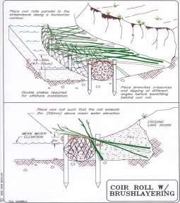
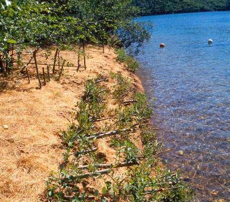
49 (1) dense or abundant emergent, floating or submerged vegetation On average, % of the bottom is visually obstructed by plants

50 (4) scattered or patchy emergent, floating or submergent vegetation On average, 1-49% of the bottom is visually obstructed by plants
51 Fetch Shoreline Geometry Shoreline Orientation Boat Wakes Bank Height Bank Composition Influence of Adjacent Structures Depth at 20 Feet Depth at 100 Feet Aquatic Vegetation Bank Stability Erosion Intensity
52 Fetch Shoreline Geometry Shoreline Orientation Boat Wakes Bank Height Bank Composition Influence of Adjacent Structures Depth at 20 Feet Depth at 100 Feet Aquatic Vegetation Bank Stability Erosion Intensity Bank Vegetation (type and abundance of vegetation occurring on the bank face and immediately on top of the bank lip) 3 choices are: (1) dense vegetation, upland trees and shrubs; (4) clumps of vegetation alternating with areas lacking vegetation; (8) lack of vegetation (cleared), crop or agricultural land.

53 ASSIGNED EI SHORELINE VARIABLES DESCRIPTIVE CATEGORIES EROSION INTENSITY VALUE IS LOCATED IN PARENTHESIS ON LEFT SIDE OF EACH CATEGORY BOX FETCH-AVERAGE, longest continuous linear distance the site across the water surface to the opposite intersect with the shore or land. DEPTH AT 20 FEET, Depth of water (feet) 20 feet from shoreline DEPTH AT 100 FEET, depth of water (feet) 100 feet from shoreline BANK HEIGHT, height of bank (feet) at the shoreline or just behind the sediment beach BANK COMPOSITION composition and degree of cementation of the sediments INFLUENCE OF ADJACENT STRUCTURES, likelihood that adjacent structures are causing flank erosion at the site AQUATIC VEGETATION type and abundance of vegetation occurring in the water off the shoreline SHORE VEGETATION type and abundance of the vegetation occurring between the bank and shoreline BANK VEGETATION, type and abundance of the vegetation occurring on the bank and immediately on top of the bank lip SHORELINE GEOMETRY general shape of the shoreline at the point of interest plus 200 yards on either side. SHORELINE ORIENTATION general geographic direction the shoreline faces BOAT WAKES proximity to and use of boat channels (0) <1/10 (2) 1/10 1/3 (4) 1/3-1 (7) 1 3 (10) 3-10 (13) (16) >30 (1) <1 (2) 1-3 (3) 3-6 (4) 6-12 (5) >12 (1) <1 (2) 1-3 (3) 3-6 (4) 6-12 (5) >12 (1)<1 (2) 1-5 (3) 5-10 (4) (5) >20 (0) Rock, marl, tight clay, well cemented sand (dig with a pick or swamp forest) (0) no hard armoring on either adjacent property (1) dense or abundant emergent, floating or submerged vegetation (0) rocky substrates unable to support vegetation. (1) hard armoring on one adjacent property (1) dense vegetation, upland trees, shrubs and grasses (7) soft clay, clayey sand, moderately cemented (easily dug with a knife) (2) hard armoring on both adjacent properties (3) hard armoring on one adjacent property with measurable recession (4) scattered or patchy emergent, floating or submergent vegetation (1) dense continuous vegetation, marsh fringe and shrubs (4) scattered or patchy vegetation, upland trees and shrubs (4) clumps of vegetation alternating with areas lacking vegetation (15) uncemented sands or peat (easily dug with you hand) (4) hard armoring on both adjacent properties with measurable recession (7) lack of emergent, floating or submergent vegetation (7) lack of vegetation (7) lack of vegetation (cleared), crop or agricultural land (1) coves (4) irregular shoreline (8) headland, point or straight shoreline (0) < 1/3 mile fetch (1) south to east (4) south to west (8) west northwest to north to east-northeast (1) no channels within 100 (6) minor thoroughfare with (12) major thoroughfare yards, broad open water body, 100 yards carrying limited within 100 yards carrying or constricted shallow water traffic, or major channel 100 intensive traffic. body yards to ½ mile offshore EROSION INTENSITY SCORE (EI)


54 Energy Category Method Low Energy Moderate Energy High Energy Wind-wave < 1 foot feet >2.3 feet Erosion Intensity >67
55 Monitoring- Erosion Pin Method Rebar Bank-lip Bank-lip Rebar Bank-face Bank toe is the inflection point between the bank face and lakebed Erosion Pins Place pins 10 feet apart at the vertical midpoint of the bank face Lake-bed


56 Monitoring- Erosion Pin Method
57 Monitoring- Erosion Pin Method


58 Shoreline Type Low Energy Moderate Energy High Energy X Treatment Type Biological Biotechnical Technical
59 Shore Protection Techniques Biological Live stakes Brush mattresses with jute roping Coir fiber rolls with jute netting Biotechnical - Vegetated Armoring Integrated Toe Protection Joint plantings among riprap Technical - Hard Armoring Rock riprap Wooden vertical seawalls Concrete retaining walls

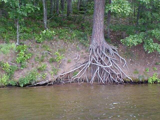
60 Vegetation - The Roots of the Solution The riparian areas of shorelines are glued together by a diversity of plants with strong, deep root systems, especially those of woody plants.

61 Vegetation - The Roots of the Solution

62 Biological Improve Water Clarity Fish and Wildlife Habitat Hold Sediments Nutrient Cycling Invertebrates Aesthetics

63 Biological

64 Biological
65

66

67 Biological


68 Biological

69 Biological

70 iological
71 Shore Protection Techniques Biological Live stakes Brush mattresses with jute roping Coir fiber rolls with jute netting Biotechnical - Vegetated Armoring Integrated Toe Protection Joint plantings among riprap Technical - Hard Armoring Rock riprap Wooden vertical seawalls Concrete retaining walls

72 Biotechnical


73 Biotechnical


74 Biotechnical

75
76

77

78

79
80 General Permit Application Review Application Completeness Verify data submitted reflects site conditions (desktop approach for both Windwave and EI) Assess whether treatment type is GP eligible Review adequacy of erosion control plan Review if GP conditions are met in the plan.
81 Windwave Modeling For All Apps-Quickly Review all data submitted for Windwave Model. Check Max Fetch on Webview. For that fetch, eyeball a mean depth estimate from a lake map to discern if the applicant s mean depth estimate is reasonable. Run the Windwave Model. Verify agreement with the applicant s energy classification. If disagreement in energy class exists with the applicant, verify that your shoreline location is correct, calculate the mean depth and rerun the model. Note for lakes<400 acres, windwave model output will always be low, nonetheless applicant should calculate a storm wave height estimate.
82 Fetch Desktop Review All Submitted EI s Shoreline Geometry Shoreline Orientation Boat Wakes Bank Height Bank Composition Influence of Adjacent Structures Depth at 20 Feet Depth at 100 Feet Aquatic Vegetation Bank Stability Bank Vegetation Red Bold Metrics Can be calculated from Desktop Estimates of the other metrics can be made from Photo Interpretation If your red bolded metrics along with the applicant s other metrics results in a different energy class, then inform the applicant of the energy reclassification and their options.
83 When to Conduct a Site Review of Applicant s EI? If your Desktop metrics along with your photo-interpreted metrics results in a different energy class and the difference between the applicants EI and your EI is due to differences in the photo-interpreted metrics.

84 Where should a WMS initiate an EI along moderate/high energy shorelines? IP s Designated sensitive areas Tributary areas and embayments Areas containing no-wake boating Photographic evidence of very low banks, zero slope profiles. Adjacent stands of emergent/floating vegetation, dense woody cover. An expansive distance of shallow water offshore. Other local knowledge
85 What Constitutes a Revegetation Plan that meets NR328 Standards? (b) Willow wattles, willow posts, brush mattresses, brush layering, fiber roll breakwaters, plant carpets, root wads, and other natural materials shall be installed by hand. (c) Vegetation shall be plant species which are native to the area of Wisconsin where the project is located. Vegetative treatments shall be installed according to Natural Resources Conservation Service Conservation Practice Standard Code 580 (Streambank and Shoreline Protection) or the Natural Resources Conservation Service Engineering Field Handbook (chapter 16). (j) Riprap or other vegetated armoring along moderate energy sites shall be revegetated above the ordinary high water mark by using native shrub plantings, native live stakes or native jointed plantings.
86 What Constitutes a Revegetation Plan that meets the Rule Standards? Plant Species List Including Only Native Plants:Species/type/number Diagrams showing planting above the OHWM along the bank face and immediately landward of the bank lip (at least one shrub layer, 5-15 depending on bank height (low Banks-5 feet, high banks 15 feet). Diagrams showing the upper limit of rock in relation to OHWM and Storm- Wave Height. A plan to incorporate plants into the rock design from the OHWM up to the top of the rock (PSWH). Or a plan to limit the rock to below the OHWM and revegetate above. Wisconsin Biology Tech Note #1 for Density Standards Give Good Advice Based on EI s--dormant Cuttings/Woody Shrubs should be encouraged on EI s above 42. Bushlayering/Brush Mattresses/etc.
87 Wisconsin Biology Tech Note #1 for Density Standards

88 Lakescaping for Wildlife and Water Quality (180 pages, $19.95, available from the Minnesota Bookstore at ). Wisconsin DNR staff recommend this book as a detailed planning guide for shoreland restoration in Wisconsin. NRCS Engineering Field Handbook Additional Informational Resources The Living Shore, a 17-minute video produced by UW-Extension and University of Minnesota Extension showing the importance of leaving a natural buffer zone between the lake and lake owners dwellings, and providing information about selecting and planting shoreline plants. Call the Wisconsin Association of Lakes ( LAKE) to order a copy for $15 plus $2 in shipping, or check your local library for a copy. A Fresh Look at Shoreland Restoration, A 4-page pamphlet describing options for restoring shoreland habitat. Available from UW-Extension # GWQ027, or the DNR, publication # DNR-FH-055 What is a shoreland buffer?, A brief ecological and legal overview of shoreland buffers. Available from the UW- Extension, publication #GWQ028 or the DNR, publication # DNR FH-233. The Water s Edge. A 12- page brochure about what you can do on your lakeshore property to improve habitat for fish and wildlife. Available from your local DNR Service Center. Life on the Edge... Owning Waterfront Property, UW-Extension. Send $3 per copy plus $1.50 for shipping and handling for a total of $4.50 (make checks payable to UW-Extension) to: UWEX-Lakes Program, College of Natural Resources, University of Wisconsin, 1900 Franklin St. Stevens Point, WI 54481

89
90 NR Subchapter III Shore Erosion Control - Rivers and Streams Why an Emergency? No statutory exemptions provided for stream/river shoreline protection Since Act 118, all projects require IP, including public notice General permits will avoid delay for 25-30% of stream/river shoreline projects for 2005
91 NR 328 Subch. III - Applicability Shore erosion control measures placed below the ordinary high water mark require authorization Practices involving grading more than 10,000 square feet on the bank require a permit, except on lands used entirely for agriculture.

92 Integrated Treatment example
93 NR 328 Subchapter III - General Permits Conditions: 1. Construction timing to protect spawning 2. Protection of coarse woody cover 3. No impact to Endangered/Threatened species 4. Designated waters - GP not available for: wetlands streams greater than 35 feet wide federal or state wild rivers (Integrated treatment)
94 NR General Permits Conditions, cont d: 5. Erosion Control and Stormwater Management 6. Maximum length for individual site (one meander) 150 feet; maximum length for project (multiple sites) 500 feet. Alternate process for large habitat projects not meeting GP standards.
95 Determining project length
Choosing a Technique and Getting a Permit
 Choosing a Technique and Getting a Permit Choosing a Technique Define cause of erosion Upland runoff? Impervious areas? Velocities? Wave energies? Boat or wind generated? Ice action? Prevailing wind direction?
PRACTICE STANDARDS AND NR 328. Choosing a Technique and Getting a Permit
 PRACTICE STANDARDS AND NR 328 Choosing a Technique and Getting a Permit CHOOSING A TECHNIQUE Define cause of erosion Upland runoff? Impervious areas? Velocities? Wave energies? Boat or wind generated?
Estuarine Shoreline Stabilization
 Estuarine Shoreline Stabilization Property Owner s Guide to Determining the Most Appropriate Stabilization Method Estuarine shorelines are dynamic features that experience continued erosion. Land is lost
Blakely Island, N Thatcher Bay. Restoration Recommendation: Rank Score (total score)
") Soft Shore Protection/Structure Removal Blueprint for San Juan County Forage Fish Beaches Appendix 2: Recommendations for sites scoring below the top ten, sorted by island (east to west) Blakely Island,
Soft Shore Protection/Structure Removal Blueprint for San Juan County Forage Fish Beaches Appendix 2: Recommendations for sites scoring below the top ten, sorted by island (east to west) Blakely Island,
Natural Shoreline Restoration for High Energy Shorelines. Brian Majka Restoration Ecologist 3/7/2019
 Natural Shoreline Restoration for High Energy Shorelines Brian Majka Restoration Ecologist 3/7/2019 Today we ll discuss: High energy shorelines Restoration techniques for high energy shorelines Project
VIMS CCRM Coastal Management Decision Tools. Decision Tree for Undefended Shorelines and Those with Failed Structures
 VIMS CCRM Coastal Management Decision Tools Decision Tree for Undefended Shorelines and Those with Failed Structures Center for Coastal Resources Management Virginia Institute of Marine Science Gloucester
JAP Additional Information Sheet
 JAP Additional Information Sheet Block 15: Purpose and Need The USACE purpose of the project is to provide a safe and reliable whitewater park for the recreational public in a city park, which will provide
For more information or permission to reprint slides, please contact Donna Milligan at 1
 For more information or permission to reprint slides, please contact Donna Milligan at milligan@vims.edu 1 For more information or permission to reprint slides, please contact Donna Milligan at milligan@vims.edu
GONE! Coastal Erosion Happens During Storms! Why Worry About Coastal Setbacks? Goals for Today
 RI Regulatory Setbacks & Buffers: Coastal Zone Management Issues New England Onsite Wastewater Training Program @ URI OWT 155 November 21, 2013 Goals for Today Understand the impacts of storms, coastal
Suitable Applications Check dams may be appropriate in the following situations: To promote sedimentation behind the dam.
 Categories EC Erosion Control SE Sediment Control TC Tracking Control WE Wind Erosion Control Non-Stormwater NS Management Control Waste Management and WM Materials Pollution Control Legend: Primary Category
Design and Construction of Living
 Design and Construction of Living Shorelines A course for living shorelines professionals September 29, 2010 This course made possible by a grant from the Virginia Coastal Zone Management Program NOAA
RI Regulatory Setbacks & Buffers: Coastal Management Issues
 RI Regulatory Setbacks & Buffers: Coastal Management Issues New England Onsite Wastewater Training Program @ URI OWT 155 - November 29, 2012 James Boyd - Coastal Policy Analyst Photo: October 30, 2012
Technical Brief - Wave Uprush Analysis Island Harbour Club, Gananoque, Ontario
 Technical Brief - Wave Uprush Analysis RIGGS ENGINEERING LTD. 1240 Commissioners Road West Suite 205 London, Ontario N6K 1C7 October 31, 2014 Table of Contents Section Page Table of Contents... i List
CHAPTER 6 10/29/2018 Clean Version REGULATING PIERS, WHARVES, MOORING BUOYS, SWIMMING RAFTS AND INFLATABLES ON ROCK LAKE
 1 2 3 4 5 6 7 8 9 10 11 12 13 14 15 16 17 18 19 20 21 22 23 24 25 26 27 28 29 30 31 32 33 34 35 36 37 38 39 40 41 42 43 44 45 46 CHAPTER 6 10/29/2018 Clean Version REGULATING PIERS, WHARVES, MOORING BUOYS,
Big Spring Creek Habitat Enhancement and Fishery Management Plans
 Big Spring Creek Habitat Enhancement and Fishery Management Plans November 5, 2012 Big Spring Events and Activities Center Newville, PA Charlie McGarrell Regional Habitat Biologist Pennsylvania Fish and
FACT SHEET MCGREGOR LAKE RESTORATION HABITAT PROJECT POOL 10, UPPER MISSISSIPPI RIVER, WISCONSIN ENVIRONMENTAL MANAGEMENT PROGRAM
 FACT SHEET MCGREGOR LAKE RESTORATION HABITAT PROJECT POOL 10, UPPER MISSISSIPPI RIVER, WISCONSIN ENVIRONMENTAL MANAGEMENT PROGRAM LOCATION McGregor Lake is located within a mid-river island in Pool 10
Chapter 10 Lecture Outline. The Restless Oceans
 Chapter 10 Lecture Outline The Restless Oceans Focus Question 10.1 How does the Coriolis effect influence ocean currents? The Ocean s Surface Circulation Ocean currents Masses of water that flow from one
Shoreline Studies Program, Department of Physical Sciences, VIMS
 Living Shoreline Training Class 2017 1 Demonstration sites discussed in this talk. 2 A shoreline management plan for the entire creek made conceptual shoreline management recommendations along every stretch
FINAL REPORT. Yonkers Creek Migration Barrier Removal Project Wonderstump Road Del Norte County. Submitted By:
 FINAL REPORT Yonkers Creek Migration Barrier Removal Project Wonderstump Road Del Norte County Submitted By: Del Norte County Community Development Department Yonkers Creek Migration Barrier Removal Project
ALTERNATIVES FOR COASTAL STORM DAMAGE MITIGATION
 ALTERNATIVES FOR COASTAL STORM DAMAGE MITIGATION Dave Basco Old Dominion University, Norfolk, Virginia, USA National Park Service Photo STRUCTURAL (changes to natural, physical system) hardening (seawalls,
Cat Island Chain Restoration
 Cat Island Chain Restoration 1820s Fox River Military Road Map to Fort Howard 1845 Chart of Green Bay & Fox River Cat Island Chain - 1938 Cat Island Brown County Aerial Photography, 1938 Historic Western
APPENDIX C VEGETATED EMERGENCY SPILLWAY. VERSION 1.0 March 1, 2011
 APPENDIX C VEGETATED EMERGENCY SPILLWAY VERSION 1.0 March 1, 2011 [NOTE: Could use a better photo more clearly showing the emergency spillway in the context of the dam.] SECTION C-1: DESCRIPTION OF PRACTICE
Living Shorelines Non-structural Erosion Control Practices Rhode Island Land & Water Summit, 2014
 Living Shorelines Non-structural Erosion Control Practices Rhode Island Land & Water Summit, 2014 D. Steven Brown (1) Kevin Ruddock (1) Rhonda Smith (2) The Nature Conservancy United States Fish and Wildlife
Habitat Development: Habitat Boulders Lawson Pier Foreshore Enhancement
 Habitat Development: Habitat Boulders Improve the existing habitat by stabilising beach sediments. Increase biodiversity by creating new habitats and colonisation opportunities. Loose cobble is unstable;
Summary of Diver Assisted Suction Harvesting Efforts. Lake Ellwood Florence County, WI
 2527 Lake Ottawa Road Iron River, MI 49935 906.284.2198 Summary of Diver Assisted Suction Harvesting Efforts Lake Ellwood Florence County, WI 2015 WDNR Mechanical Harvesting Permit Annual Report Permit
ALTERNATIVES FOR COASTAL STORM DAMAGE MITIGATION AND FUNCTIONAL DESIGN OF COASTAL STRUCTURES
 The University of the West Indies Organization of American States PROFESSIONAL DEVELOPMENT PROGRAMME: COASTAL INFRASTRUCTURE DESIGN, CONSTRUCTION AND MAINTENANCE A COURSE IN COASTAL DEFENSE SYSTEMS I CHAPTER
Jason Blackburn, Paul Hvenegaard, Dave Jackson, Tyler Johns, Chad Judd, Scott Seward and Juanna Thompson
 Alberta Conservation Association (ACA) Date: 2014-2015 Project Name: Owl River Walleye and Aquatic Habitat Assessment Fisheries Program Manager: Peter Aku Project Leader: Tyler Johns Primary ACA staff
Tittabawassee River Assessment. Miles. Gladwin Smallwood Impoundment. Harrison. Clare. Midland. Mt. Pleasant. St. Louis. Saginaw.
 Warmouth Lepomis gulosus feeding - clear lakes and impoundments and very low-gradient streams - abundant aquatic vegetation - silt-free water - mucky substrate often covered with organic debris spawning
Tracy E. Skrabal. October 2, 2012
 Tracy E. Skrabal October 2, 2012 Jurisdiction Living Shorelines/Sills Timeline for Permit Bulkhead/Revetments North Atlantic Division New England Division suspended all nationwide permits March 20, 2012
REVETMENTS. Purposes and Operational Constraints. Purposes Erosion control o o. Revetment Design 4/5/2016. CE A676 Coastal Engineering
 REVETMENTS Ijsseldam, the Netherlands Orson P. Smith, PE, Ph.D. Instructor Purposes and Operational Constraints Purposes Erosion control o o Embankment Toe protection for a seawall, retaining wall or other
ABSTRACT INTRODUCTION
 Sengupta, M. and Dalwani, R. (Editors). 2008 Proceedings of Taal2007: The 12 th World Lake Conference: 1022-1027 Water Erosion Control Using the Fetch Calculator. Applications for Constructed Wetlands
Shoreline Erosion Control Failures and How To Avoid Them
 2008 Illinois Lake Management Association Shoreline Erosion Control Failures and How To Avoid Them by: Hank Sutton, President, Lake Rip Rap, Inc. www.lakeriprap.com - www.macoupinboats.com Setting the
CHAPTER 4 - SHORELINE PROTECTION STUDY AND PLAN
 CHAPTER 4 Shoreline Protection Study and Plan 4-1 CHAPTER 4 - SHORELINE PROTECTION STUDY AND PLAN I. SHORELINE PROTECTION STUDY Lancaster County is a coastal community that has, as previously stated, approximately
LaSalle Park Marina Wave Break
 LaSalle Park Marina Wave Break Federal and Municipal Environmental Assessment Background History of the Marina and LaSalle Park The LaSalle Park Marina is located in LaSalle Park at the foot of LaSalle
Lecture Outlines PowerPoint. Chapter 15 Earth Science, 12e Tarbuck/Lutgens
 Lecture Outlines PowerPoint Chapter 15 Earth Science, 12e Tarbuck/Lutgens 2009 Pearson Prentice Hall This work is protected by United States copyright laws and is provided solely for the use of instructors
EcoLogic Memorandum. TO: Ben Brezell; EDR FROM: Mark Arrigo RE: Possible Impacts of Dredging Snooks Pond DATE: 6/4/07
 EcoLogic Memorandum TO: Ben Brezell; EDR FROM: Mark Arrigo RE: Possible Impacts of Dredging Snooks Pond DATE: 6/4/07 Background EDR P.C. (EDR) has been contracted by a landowner to assess the feasibility
(Revised February,2005) CULVERTS, BRIDGES, AND FORDS
 CULVERTS, BRIDGES, AND FORDS") GUIDE TO STREAM CROSSINGS (Revised February,2005) CULVERTS, BRIDGES, AND FORDS Culverts, bridges, and fords are all methods used to cross-streams. Culverts are the most common stream crossing structure.
GUIDE TO STREAM CROSSINGS (Revised February,2005) CULVERTS, BRIDGES, AND FORDS Culverts, bridges, and fords are all methods used to cross-streams. Culverts are the most common stream crossing structure.
Creation of Fish and Wildlife Habitat on the Closed Salmon Harbour Mine in Minto, NB
 Creation of Fish and Wildlife Habitat on the Closed Salmon Harbour Mine in Minto, NB M. Coleman 1, R. Rutherford 2, RA Currie 3 1 NB Power 2 Thaumas Environmental Consultants Ltd 3 RA Currie Ltd. Location
RESILIENCE THROUGH RESTORATION
 RESILIENCE THROUGH RESTORATION RECLAMATION DISTRICT NO. 1601 TWITCHELL ISLAND SAN JOAQUIN RIVER SETBACK LEVEE PROJECT TWITCHELL ISLAND BASICS Nearly 12 miles of levee Storm drainage facilities Protects
Design Considerations for Living Shorelines in Connecticut. Jennifer E.D. O Donnell Department of Marine Sciences University of Connecticut
 Design Considerations for Living Shorelines in Connecticut Jennifer E.D. O Donnell Department of Marine Sciences University of Connecticut October 2015 1 Contents Contents... 2 1 Why Living Shorelines?...
Water Resources Report RKLD Annual Meeting July 30, 2016
 Water Resources Report RKLD Annual Meeting 2016 July 30, 2016 Topics Hydrology Report Indianford Dam trash rack cleanout performance Experimental Project update Review of PAS project Twin floods- 1 to
CITY OF MADISON PROPOSED PROJECT. Wingra Park Shoreline Repair
 CITY OF MADISON PROPOSED PROJECT Wingra Park Shoreline Repair Wingra Park Current Shoreline Wingra Shoreline Wingra Shoreline Wingra Shoreline Wingra Shoreline Wingra Shoreline Concrete Abutment + Wooden
Understanding Types and Benefits of Fish Habitat
 Understanding Types and Benefits of Fish Habitat Leonard Dane Fisheries Biologist Deuchler Environmental, Inc. ILMA POD April 14, 2015 Wauconda, IL Importance of Fish Habitat What is fish habitat? those
Mid-Columbia Fisheries Enhancement Group Annual Report Fiscal Year 06: July 1, 2005 June 30, 2006
 Mid-Columbia Fisheries Enhancement Group Annual Report Fiscal Year 06: July 1, 2005 June 30, 2006 Mission Statement The mission of the Mid-Columbia Fisheries Enhancement Group is to restore self-sustaining
Starry Stonewort in Silver Lake Washington County, WI BRAD STECKART AIS COORDINATOR FOR WASHINGTON AND WAUKESHA COUNTIES
 Starry Stonewort in Silver Lake Washington County, WI BRAD STECKART AIS COORDINATOR FOR WASHINGTON AND WAUKESHA COUNTIES Brad Steckart -AIS coordinator for Washington and Waukesha Counties -Graduated from
TO: FROM: Y.102/MIN
 TO: FROM: Hastings-on-Hudson Shoreline Committee Amanda Ludlow and Kathryn Sommo, Roux Associates, Inc. DATE: March 13, 2017 RE: Meeting with NYSDEC Region 3 Hastings-on-Hudson Conceptual Shoreline Plans
PREPARE TO LAUNCH! DESIRED LAUNCH CHARACTERISTICS Updated April User Accessibility. Site Location Appropriateness
 DESIRED LAUNCH CHARACTERISTICS Updated April 2018 User Accessibility Site Location Appropriateness Cost Considerations / Trade-offs Environmentallyfriendly There are four primary questions to answer in
Technical Brief - Wave Uprush Analysis 129 South Street, Gananoque
 Technical Brief - Wave Uprush Analysis 129 South Street, Gananoque RIGGS ENGINEERING LTD. 1240 Commissioners Road West Suite 205 London, Ontario N6K 1C7 June 12, 2013 Table of Contents Section Page Table
City of Burnaby Environmental Review Committee (ERC) Guide for Applicants
 Guide for Applicants") City of Burnaby Environmental Review Committee (ERC) Guide for Applicants 2017-2018 This Guide summarizes the ERC process for project review including applications for a relaxation (variance) to the development
City of Burnaby Environmental Review Committee (ERC) Guide for Applicants 2017-2018 This Guide summarizes the ERC process for project review including applications for a relaxation (variance) to the development
Geomorphic Stream Classification A Classification of Natural Rivers, Rosgen, D.L.
 Geomorphic Stream Classification A Classification of Natural Rivers, Rosgen, D.L. Why is Stream Classification Physical stream channel evolution Essential? Similar stream types manifest similar patterns
River Restoration: Culvers Island weir removals and river naturalisation project.
 River Restoration: Culvers Island weir removals and river naturalisation project. Background Chalk streams are an incredibly rare habitat on a global scale, and owing to their international importance,
Examples of estuaries include bays, sounds, salt marshes, mangrove forests, mud flats, swamps, inlets, and sloughs.
 An estuary is a partially enclosed body of water where incoming seawater is mixed with fresh water coming from the land. Examples of estuaries include bays, sounds, salt marshes, mangrove forests, mud
Florida Seagrass Integrated Mapping and Monitoring Program
 Florida Seagrass Integrated Mapping and Monitoring Program - 2004 The following document is composed of excerpts taken from the 2011 publication, Seagrass Integrated Mapping and Monitoring for the State
Stevens Creek Corridor
 O F F I C E O F T H E D I R E C T O R O F P U B L I C W O R K S Stevens Creek Corridor Creek Restoration Project Volume Three Project Update: Creek Photos, Before & After BY GAIL SEEDS - PROJECT MANAGER,
feeding - clear moderate-sized shallow streams with moderate vegetation spawning - nests in gravel, sand, or hard rock substrate
 orthern longear sunfish (Lepomis peltastes) feeding - clear moderate-sized shallow streams with moderate vegetation - rocky substrates - little to no current spawning - nests in gravel, sand, or hard rock
Trout Unlimited Comments on the Scope of Environmental Impact Statement for the Constitution Pipeline Project, Docket No. PF12-9
 October 9, 2012 Kimberly D. Bose, Secretary Federal Energy Regulatory Commission 888 First Street, NE, Room 1A Washington, DC 20426 RE: Trout Unlimited Comments on the Scope of Environmental Impact Statement
Identifying Areas with Potential to Contain High Value Fish Habitat (HVFH) June 2007
 June 2007") Identifying Areas with Potential to Contain High Value Fish Habitat (HVFH) June 2007 1 High Value Fish Habitat INTENT: To apply added precautionary protection to those special areas deemed of high value
Identifying Areas with Potential to Contain High Value Fish Habitat (HVFH) June 2007 1 High Value Fish Habitat INTENT: To apply added precautionary protection to those special areas deemed of high value
Puget Sound Shorelines. Waves and coastal processes. Puget Sound shorelines: Effects of beach armoring
 Puget Sound Shorelines Puget Sound shorelines: Effects of beach armoring Waves and coastal processes Factors affecting wave energy hitting the coast Processes transporting sediment along coastlines What
Minnesota Department of Natural Resources Division of Fish and Wildlife Section of Fisheries. Stream Survey Report. Luxemburg Creek.
 Minnesota F-29-R(P)-24 Area 315 Study 3 March 2016 Minnesota Department of Natural Resources Division of Fish and Wildlife Section of Fisheries Stream Survey Report Luxemburg Creek 2015 Mark Pelham Sauk
Rehabilitation of Grimes Creek, a Stream Impacted in the Past by Bucket-lined Dredge Gold Mining, Boise River Drainage, July 2008 to August 2011.
 Rehabilitation of Grimes Creek, a Stream Impacted in the Past by Bucket-lined Dredge Gold Mining, Boise River Drainage, July 2008 to August 2011. Pam Harrington TU,1020 W. Main Street Suite 440, Boise,
Tips for Using & Printing Spreadsheets
 Key to Spreadsheets Spreadsheet # Type Description/Purpose a Development & Construction in Waterways b Debits Development & Construction in Other Aquatic Areas c Indirect Impacts to Waterways from Development
Cross-Vane Plan View FIN-UP Habitat Consultants, Inc. 220 Illinois Avenue Manitou Springs, CO (719) P.
 P.") STREAM CHANNEL STRUCTURE DRAWINGS ISIONS W (Channel Width) (Varies) Thalweg & Flow Direction Individually Placed Footer Rocks 5' to 6' by 2' thick (Min. 2 rows of footer rocks placed tightly together with
STREAM CHANNEL STRUCTURE DRAWINGS ISIONS W (Channel Width) (Varies) Thalweg & Flow Direction Individually Placed Footer Rocks 5' to 6' by 2' thick (Min. 2 rows of footer rocks placed tightly together with
Great Lakes Stream Crossing Inventory Instructions
 Great Lakes Stream Crossing Inventory Instructions This document is a guide to completing the Stream Crossing Data Sheet (2/28/11 version). Careful attention to this guidance will ensure consistent crossing
VWP CONSTRUCTION INSPECTION REPORT. Project Name: Berkmar Drive Extension Locality: Albemarle County Inspector: ERM
 VWP CONSTRUCTION INSPECTION REPORT Inspection Date: August 22, 2016 VWP Permit No. 15-1268 SPGP RO Project Name: Berkmar Drive Extension Locality: Albemarle County Inspector: ERM Impacts: PFO PEM PSS POW
Current Status and Management Recommendations for the Fishery in the Cloverleaf Chain of Lakes
 Current Status and Management Recommendations for the Fishery in the Cloverleaf Chain of Lakes Jason Breeggemann Senior Fisheries Biologist Wisconsin Department of Natural Resources Outline DNR fisheries
Fish Habitat Design, Operation and Reclamation Worksheets for
 Fish Habitat Design, Operation and Reclaation Worksheets for Appendix A Project Location Worksheet Applicant Nae: Strea Nae: Watershed Nae: Fish Habitat Suitability Classification Water Quality Zone Operation
Part 9 Specific Land Uses - Foreshore & Waterway Development
 7 FORESHORE AND WATERWAY DEVELOPMENT This section applies to the following development uses proposed within the foreshore area (defined by LM LEP 2014), and contains Council s specific requirements for
Illinois Lake Management Association Conference March 23, 2018 By Trent Thomas Illinois Department of Natural Resources Division of Fisheries
 Illinois Lake Management Association Conference March 23, 2018 By Trent Thomas Illinois Department of Natural Resources Division of Fisheries Sources of Habitat Impairment Sedimentation Channelization
Minnesota Department of Natural Resources Division of Fish and Wildlife Section of Fisheries. Stream Survey Report. Cold Spring Creek.
 Minnesota F-29-R(P)-24 Area 315 Study 3 March 2013 Minnesota Department of Natural Resources Division of Fish and Wildlife Section of Fisheries Stream Survey Report Cold Spring Creek 2012 Mark Pelham Montrose
CHAPTER 4 DESIRED OUTCOMES: VISION, GOALS, AND OBJECTIVES
 CHAPTER 4 DESIRED OUTCOMES: VISION, GOALS, AND OBJECTIVES Vision One of the first steps in developing this Plan was articulating a vision - a clear statement of what the Plan strives to achieve and what
Welcome to Paddle for the Edge!
 Welcome to Paddle for the Edge! Thank you for volunteering to conduct a survey of the Barnegat Bay s shorelines. As a citizen scientist, you become part of a project to collect critical data about current
MISSISSIPPI MAKEOVER A Plan for Restoration, Just Around the Bend
 MISSISSIPPI MAKEOVER A Plan for Restoration, Just Around the Bend Interim Report Card 2013 Project coordinated by the Dakota County Soil and Water Conservation District and sponsored by the Minnesota Pollution
Lake information report
 Page of 5 Lake information report Name: Whitewater Nearest Town: Hoyt Lakes Primary County: St. Louis Survey Date: 08/3/2007 Inventory Number: 69037600 Public Access Information Ownership Type Description
Management of Hybrid Watermilfoil (Myriophyllum sibericum x spicatum) using Diver Assisted Suction Harvesting
 using Diver Assisted Suction Harvesting") 2527 Lake Ottawa Road Iron River, MI 49935 906.284.2198 Management of Hybrid Watermilfoil (Myriophyllum sibericum x spicatum) using Diver Assisted Suction Harvesting Lake Ellwood, Florence, WI - 2014 Final
2527 Lake Ottawa Road Iron River, MI 49935 906.284.2198 Management of Hybrid Watermilfoil (Myriophyllum sibericum x spicatum) using Diver Assisted Suction Harvesting Lake Ellwood, Florence, WI - 2014 Final
Conservation and Restoration Florida s Coastal Marshes: An Overview of MESS. Jeff Beal, Kent Smith, Erin McDevitt, Maria Merrill
 Conservation and Restoration Florida s Coastal Marshes: An Overview of MESS Jeff Beal, Kent Smith, Erin McDevitt, Maria Merrill FWC s MESS: -Marine/Estuarine Subsection -within Aquatic Habitat Conservation
La Quinta Channel Extension Port of Corpus Christi Ingleside, Texas. Mark Coyle
 La Quinta Channel Extension Port of Corpus Christi Ingleside, Texas Mark Coyle Corpus Christi Navigation Channel PCCA La Quinta Expansion Project History Corpus Christi Ship Channel Improvement Projects
Oceans and Coasts. Chapter 18
 Oceans and Coasts Chapter 18 Exploring the oceans The ocean floor Sediments thicken and the age of the seafloor increases from ridge to shore The continental shelf off the northeast United States Constituent
Coastal management has lagged behind the growth in population leading to problems with pollution
 Fifty percent of the population of the industrialized world lives within 100 km of a coast. Coastal management has lagged behind the growth in population leading to problems with pollution and natural
Steelhead Society of BC. Thompson River Watershed Restoration and Enhancement Project #4 Nicola River Bank Stabilization and Enhancement Project
 Steelhead Society of BC Presents: Thompson River Watershed Restoration and Enhancement Project #4 Nicola River Bank Stabilization and Enhancement Project Application for Funding December 2013 1.0 BACKGROUND
Creek Trash Assessment (CTA) Methodology (Demonstration: Mill Run Creek, Cheltenham, Pa.)
 Methodology (Demonstration: Mill Run Creek, Cheltenham, Pa.)") Creek Trash Assessment (CTA) Methodology (Demonstration: Mill Run Creek, Cheltenham, Pa.) Mill Run Creek emerges from a storm sewer in Philadelphia to an open creek in Cheltenham. The Creek downstream
Creek Trash Assessment (CTA) Methodology (Demonstration: Mill Run Creek, Cheltenham, Pa.) Mill Run Creek emerges from a storm sewer in Philadelphia to an open creek in Cheltenham. The Creek downstream
The Cumulative Impacts of Shoreline Armoring on Forage Fish Spawning Habitat in San Juan County, Washington
 Western Washington University Western CEDAR Salish Sea Ecosystem Conference 2014 Salish Sea Ecosystem Conference (Seattle, Wash.) May 1st, 1:30 PM - 3:00 PM The Cumulative Impacts of Shoreline Armoring
Pend Oreille County Shoreline Master Program User Guide April Funded through a grant from the Washington State Department of Ecology
 Pend Oreille County Shoreline Master Program User Guide April 2016 Funded through a grant from the Washington State Department of Ecology TABLE OF CONTENTS 1 Shoreline Master Program Overview 1 2 Frequently
BIG TWIN LAKE Kalkaska County (T28N, R05W, Section 18, and T28N, R06W, Section 13) Surveyed May 1999
 Surveyed May 1999") Michigan Department of Natural Resources Status of the Fishery Resource Report No. 2001-1, Year 2001 BIG TWIN LAKE Kalkaska County (T28N, R05W, Section 18, and T28N, R06W, Section 13) Surveyed May 1999
Michigan Department of Natural Resources Status of the Fishery Resource Report No. 2001-1, Year 2001 BIG TWIN LAKE Kalkaska County (T28N, R05W, Section 18, and T28N, R06W, Section 13) Surveyed May 1999
Beach profile surveys and morphological change, Otago Harbour entrance to Karitane May 2014 to June 2015
 Beach profile surveys and morphological change, Otago Harbour entrance to Karitane May 2014 to June 2015 Prepared for Port Otago Ltd Martin Single September 2015 Shore Processes and Management Ltd Contact
Reading Material. Inshore oceanography, Anikouchine and Sternberg The World Ocean, Prentice-Hall
 Reading Material Inshore oceanography, Anikouchine and Sternberg The World Ocean, Prentice-Hall BEACH PROCESSES AND COASTAL ENVIRONMENTS COASTAL FEATURES Cross section Map view Terminology for Coastal
Schedule for Culvert Works in or on the Bed or Bank of a Watercourse PLEASE READ THIS PAGE BEFORE COMPLETING THE APPLICATION FORM
 10A Schedule for Culvert Works in or on the Bed or Bank of a Watercourse This form is to be used for applications to use, erect, place, extend, alter or replace a culvert in or on the beds or banks of
Marine Ecosystems. Aquatic Ecosystems Section 2
 Marine Ecosystems Marine ecosystems are located mainly in coastal areas and in the open ocean. Organisms that live in coastal areas adapt to changes in water level and salinity. Organisms that live in
Energy Attenuation & Hybrid Living Shorelines: A Viable Tool for Coastal Resilience
 Energy & Hybrid Living Shorelines: A Viable Tool for Coastal Resilience Hot Topic Session Delaware Estuary Science & Environmental Summit Balancing Progress & Protection 10 Years of Science in Action January
COMPENSATION LAKE DESIGN CONCEPTS AND CONSTRUCTION LESSONS LEARNED
 SMA Environmental Forum 2016 COMPENSATION LAKE DESIGN CONCEPTS AND CONSTRUCTION LESSONS LEARNED Month A Tale DD, of YYYY Two Lakes Pamela Kuipers, P.Eng., MSc EXPLORE the Depths of our Experience www.norwestcorp.com
HARBOR INFRASTRUCTURE INVENTORIES Fairport Harbor, OH
 HARBOR INFRASTRUCTURE INVENTORIES Fairport Harbor, OH Harbor Location: Fairport Harbor is located at the mouth of the Grand River on the southern shore of Lake Erie in the city of Fairport, OH, approximately
Building Coastal Resiliency at Plymouth Long Beach
 Building Coastal Resiliency at Plymouth Long Beach Department of Marine and Environmental Affairs March 30, 2017 Introducing Green Infrastructure for Coastal Resiliency Plymouth Long Beach & Warren s Cove
Culvert Design for Low and High Gradient Streams in the Midwest. Dale Higgins, Hydrologist Chequamegon-Nicolet National Forest
 Culvert Design for Low and High Gradient Streams in the Midwest Dale Higgins, Hydrologist Chequamegon-Nicolet National Forest Overview Culvert Design Considerations Hydraulic Terms Culvert Impacts Low
Klickitat County Shoreline Master Program Update. Open House March 15, 2017
 Klickitat County Shoreline Master Program Update Open House March 15, 2017 Agenda 6:00 6:10 Welcome 6:10 6:40 Presentation SMP Update Process Shoreline Analysis review 6:40 8:00 Open House Topics SMP Process
Friends of the Detroit River Habitat Restoration Project Update
 Friends of the Detroit River Habitat Restoration Project Update 11 Beneficial Use Impairments (BUIs) were originally identified to be associated with the Detroit River: 1. Restrictions on fish and wildlife
Figure 1. Schematic illustration of the major environments on Mustang Island.
 STOP #1: PACKERY CHANNEL BEACH TO BAY We will start this field guide near the north jetty of Packery Channel and hike across the island to Corpus Christi Bay (fig. 1). The island emerges from the Gulf
Brief History of Headland Breakwaters Usage in Chesapeake Bay, USA. 25 Years of Rock, Sand and Plants for Shore Protection
 Brief History of Headland Breakwaters Usage in Chesapeake Bay, USA. 25 Years of Rock, Sand and Plants for Shore Protection Beach Tech 2011 C. Scott Hardaway, Jr., Geologist, Virginia Institute of Marine
Lake Shamineau Association Spring Membership Meeting May 27, 2006 Scandia Valley Town Hall
 Lake Shamineau Association Spring Membership Meeting May 27, 2006 Scandia Valley Town Hall Board members present: Vern Sowada, Mike Fedde, George Gammon, Terry Sandstrom, Al Doree, Deryl Ramey, Pat Crawford,
X.B WETLANDS ROGUE RIVER ESTUARY
 X.B WETLANDS ROGUE RIVER ESTUARY The Rogue River has a drainage area of 5,100 square miles, yet the estuary of the Rogue River is one of the smallest in Oregon, measuring approximately 1,880 acres during
The Blue Heron Slough Conservation Bank
 1 The Blue Heron Slough Conservation Bank CONSERVATION BANKING July 19-23, 2010 CASE STUDY SERIES The Blue Heron Slough Conservation Bank (Washington) I. OVERVIEW & BACKGROUND: Location: Snohomish River
Warm-up # 7 A day 5/17 - B day 5/18 UPDATE YOUR TABLE OF CONTENTS
 Warm-up # 7 A day 5/17 - B day 5/18 UPDATE YOUR TABLE OF CONTENTS Question: List all examples of surface water on Earth. Answer: Rivers and streams, lakes and reservoirs, (ponds) wetlands, estuaries and