Brief History of Headland Breakwaters Usage in Chesapeake Bay, USA. 25 Years of Rock, Sand and Plants for Shore Protection
|
|
|
- Silvester Wilson
- 6 years ago
- Views:
Transcription

1 Brief History of Headland Breakwaters Usage in Chesapeake Bay, USA. 25 Years of Rock, Sand and Plants for Shore Protection Beach Tech 2011 C. Scott Hardaway, Jr., Geologist, Virginia Institute of Marine Science James R. Gunn, President, Coastal Design and Construction, Inc.


2 Chesapeake Bay Breakwater Data Base. Selected Sites.
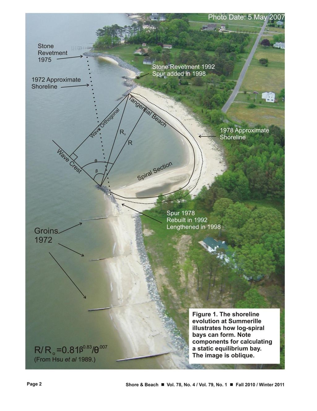
3 Early on 1979: Hardaway attends Coastal Engineering course at USC sponsored by Miles Hayes and taught by Richard Silvester. Some other students included Tim Kana, Jeff Williams, Kenny Finklestein and Phil Vitae. So began the research by VIMS on spiral bays/pocket beaches 1980:Hawk Anderson and Jim Gunn were experimenting with perched beaches and spurs The time had come to apply the research Summerille Spur 1983: Early experimentation with Silvester s spiral bay relationships with pocket beaches. The tangential section aligns with the impinging wave climate and the updrift or shadow section follows a logrithmic spiral.
4

5 Summerille/Staples, Coastal bay evaluation and predicted bay shoreline using SEB
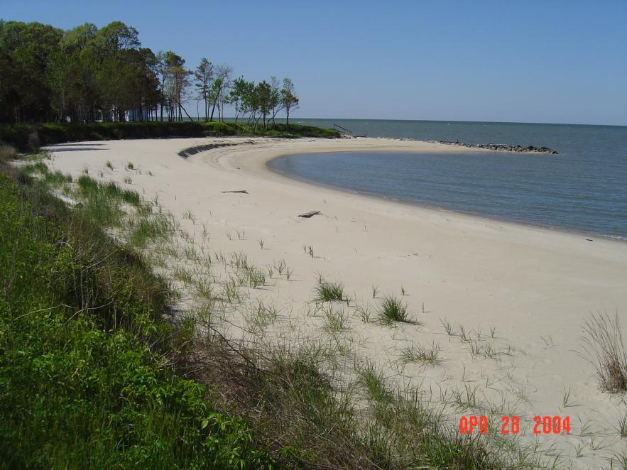
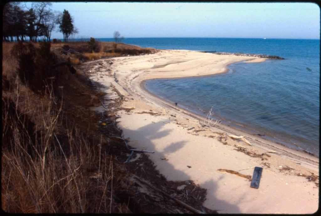
6 Summerille/Staples March 8, 1988 April
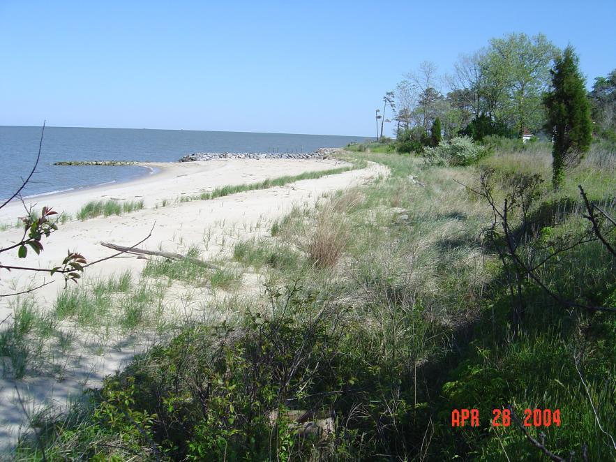
7 Summerille/Staples March 8, 1988 April

8 Offsets and differential erosion often creates geomorphic opportunities
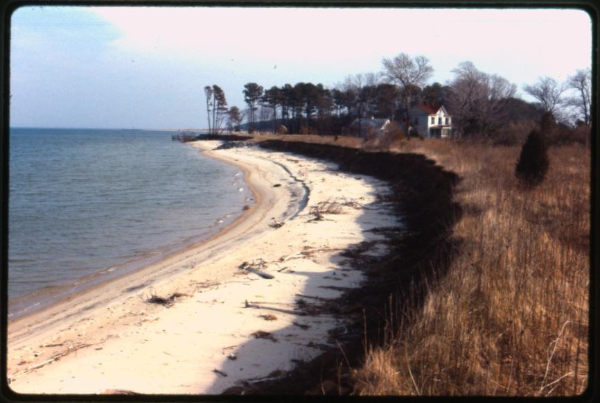
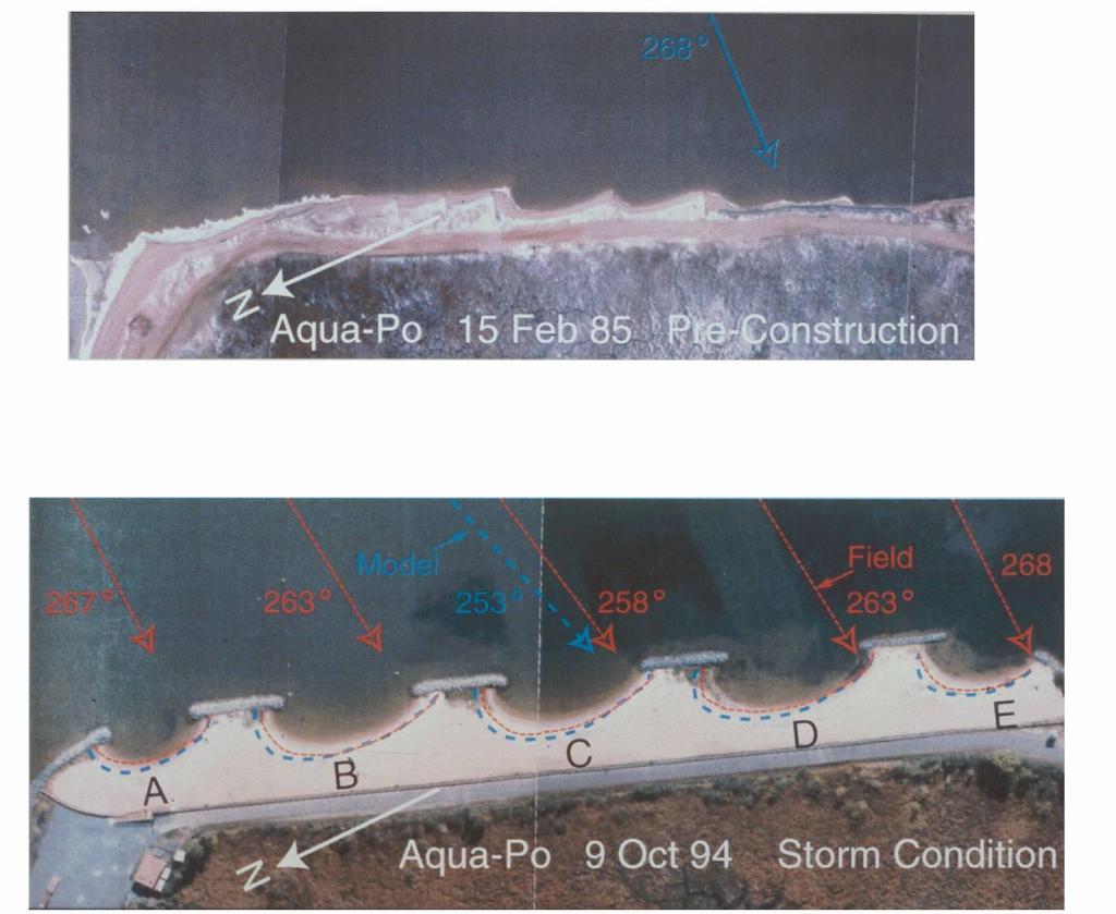
9 Mid-1980s Drummond Field-1985: First breakwater project on private property. Existing headland morphology was used to position headland breakwater system Aqua-po- 1987: Public Beach application with existing groin field used to indicate net direction of wave approach.

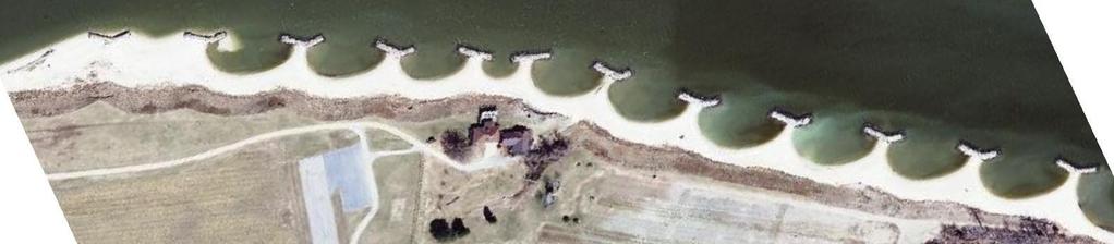
10 Drummond -Installed November 1985 Aerial Date: 2005

11 Drummond Field: March 17, 1990 Existing headllands

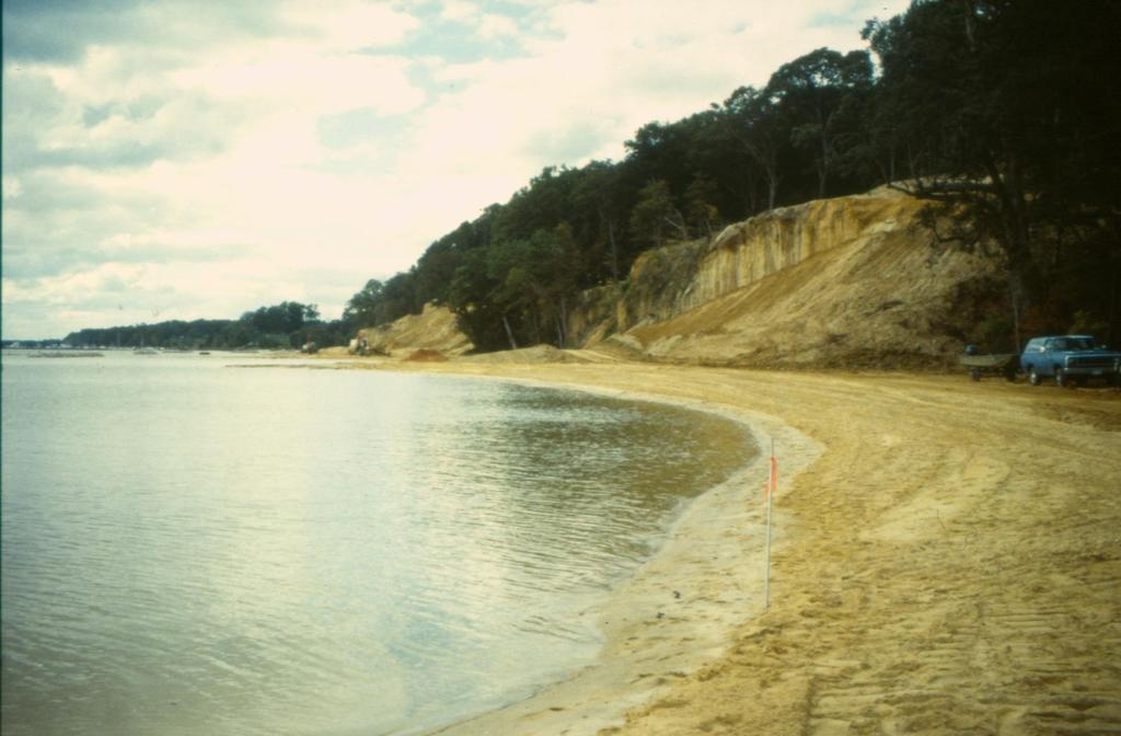
12 Drummond Field under construction: Summer 1985
13

14 Drummond Field: First tombolo

15 Drummond Field: April 7, 2010

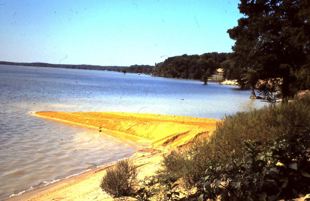
16 Aqua-Po Public Beach: Installed March 1987
17

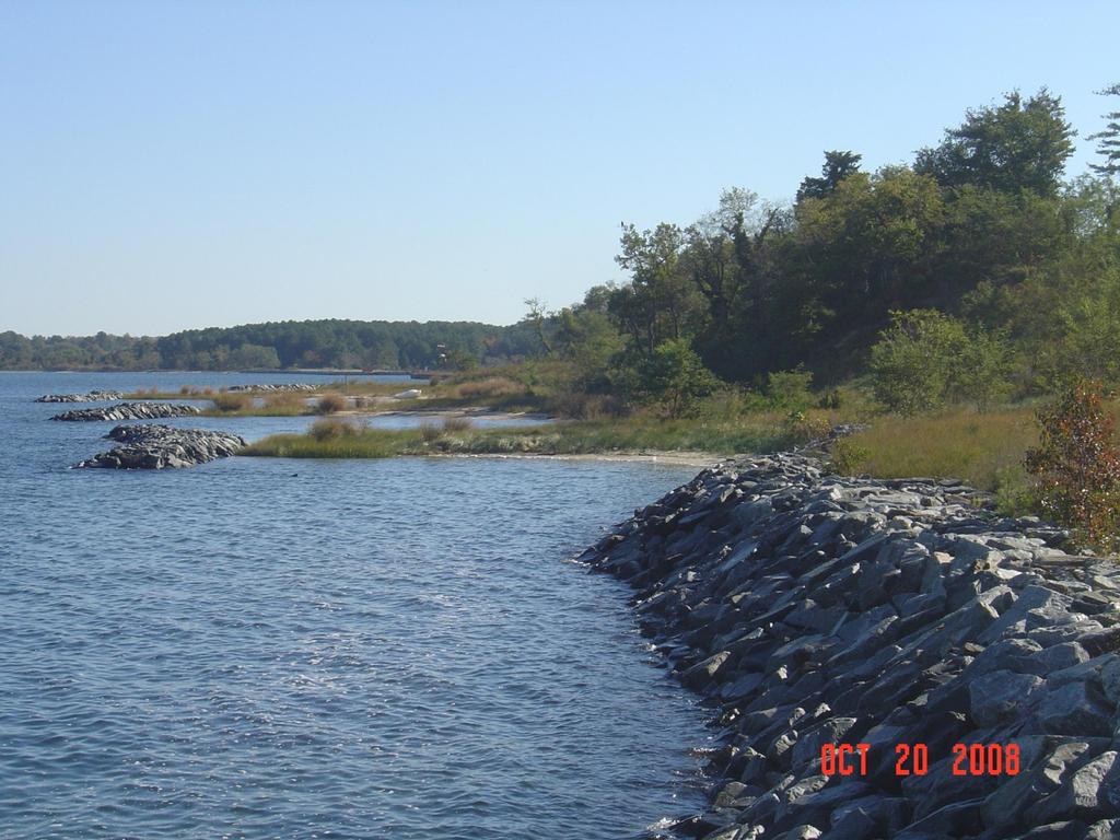
18 Aqua-Po: October 2009
19 Late 1980s, Maryland Non-Structural Program sites Claiborne- 1988: Headland breakwaters on marsh coast. Required rock sills at creek entrance. Elm s Beach- 1988: Headland breakwaters on open Chesapeake Bay. Survived Hurricane Isabel (2003)very well. Ware and Dietrick et al-1989: Choptank River breakwaters with small fetch warranted reduction in breakwater parameters such as length, gap and distance offshore Carden- 1989: Headland breakwaters used to protect spit on Potomac River in Va.

20 Claiborne Landing: 2010

21 Claiborne Landing

22 Elm s Beach: September 2000 Installed 1988.

23 Elm s Beach: Post Isabel, October 2003

24 Elms Beach: October 20, 2009

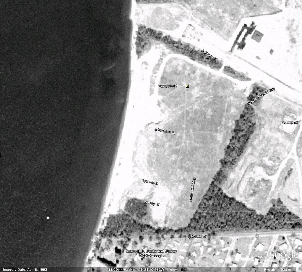
25 Dietrick: Installed October 1989 Some Dude Ware: Installed Sept. 1989

26 Carden: January 2006 Installed December 1989

27 Carden: September 2004
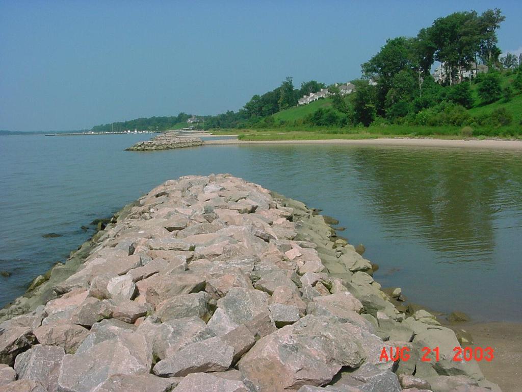
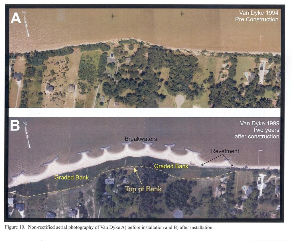
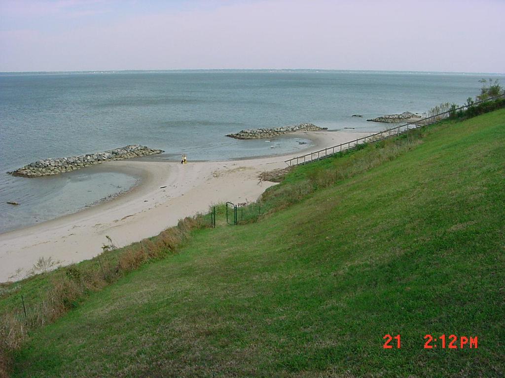
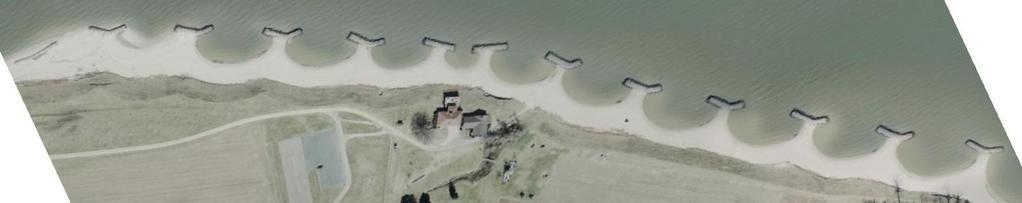
28 The 1990s Yorktown: First three breakwaters installed in 1994 and added onto over the next 10 years to total 12. Revitalized the historic waterfront along with addition of floating concrete docks. Asbury 1995:Beach sands acqiured from adjacent banks. Kingsmill : High banks with impressive viewshed warranted large headland and bay couplets VanDyke-1997: Took 10 property owners 5 years to come together. Utilized sand from the banks for beach fill.

29 Yorktown Beach: Northeaster Novemeber 2009
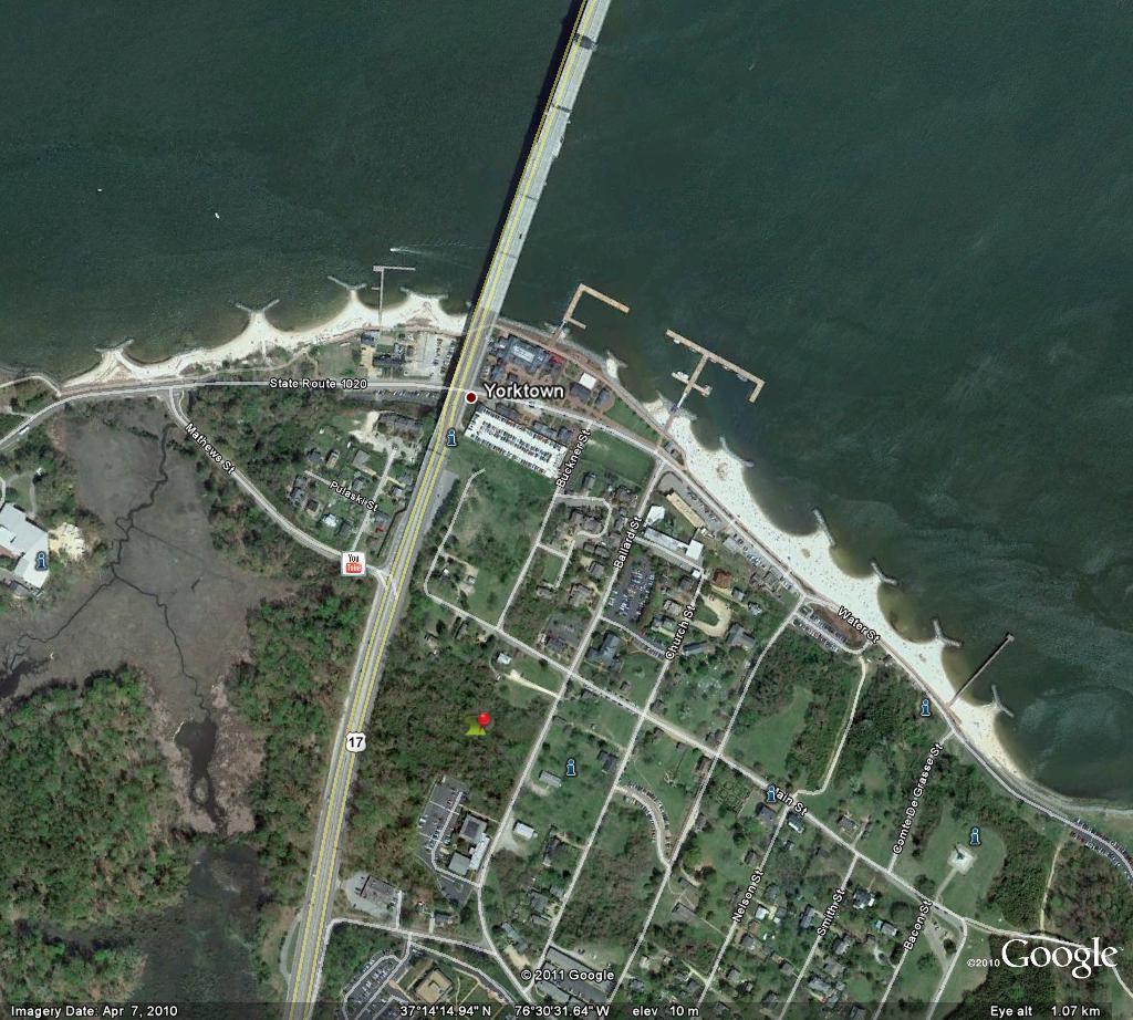
30

31 Yorktown: 2010
32 Asbury: Pre-construction

33 Asbury: March 2007


,")
34 Shore Protection Asbury, Patuxent River Asbury site before the project (November 1994), after the project (October 1998), and in August 2000.

35 Asbury: 2008
36
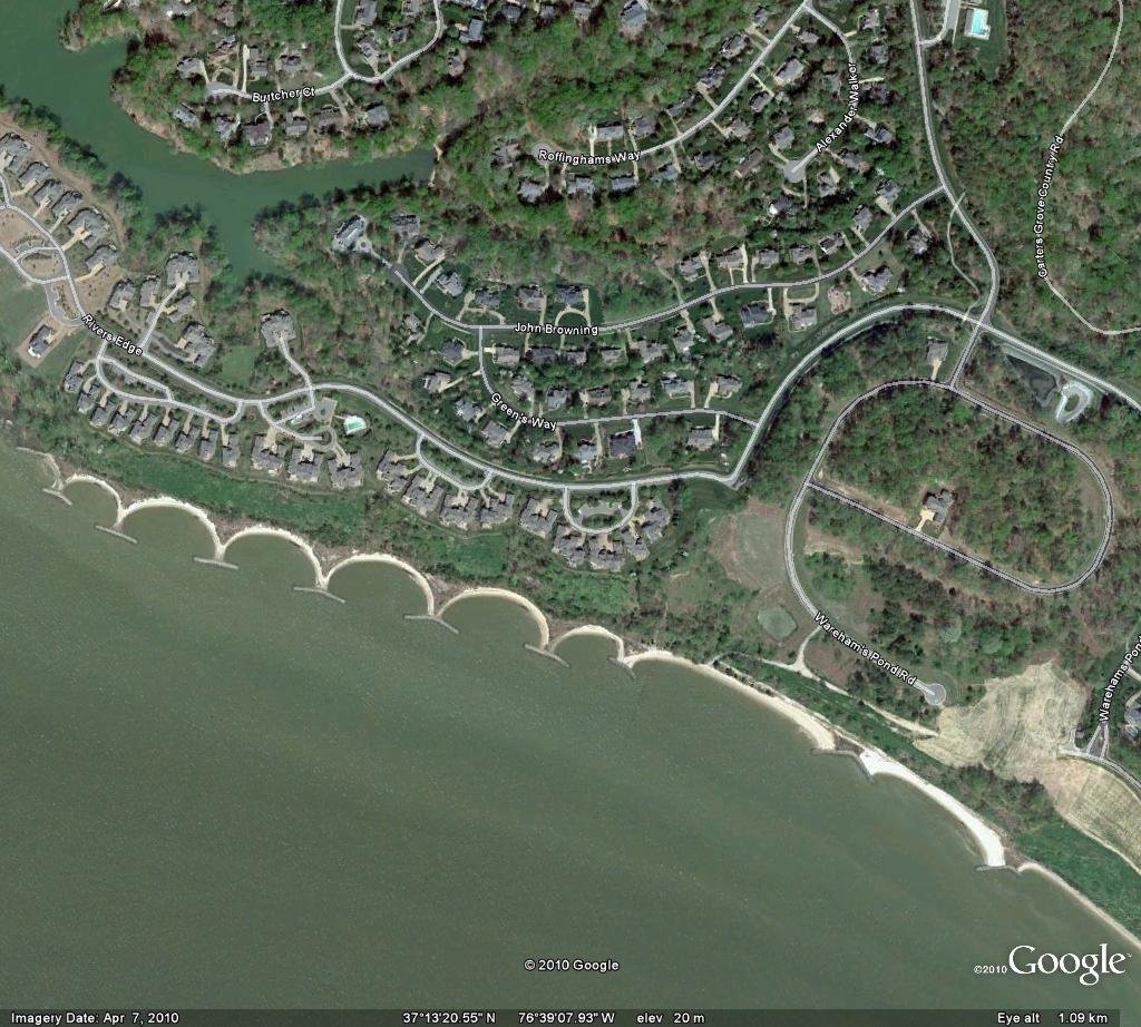
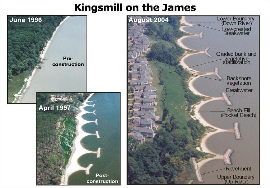
37 Kingsmill: 2010
38 Kingsmill, pre-construction: 1996
39 Kingsmill: 2002

40 James River Sites West Bank/Boykin: 2002 Van Dyke: 1997 Mogarts: 2010 Luter: 1998
41
42 VanDyke: Post-Isabel

43 VanDyke: 2007

44 Luter

45 Luter: January 2010


46 Annual Significant Winds Annual Significant Fetch Farshore Fetch Windows Storm Fetch Storm Winds Tangential Beach Control Line (R ) O Wave Crest Line Orthogonal R 90 R/R =0.81 O Annual Resultant Wave Vectors H& at Site L B SMB Output (H&T) RCP WAVE Input Storm RCPWAVE Bathymetric Grid Wave Orthogonal Diffraction Point Possible Headland Alignment Spiral Beach Section Possible Extent of Headland BW Spiral Section Tangent B m G B M b Tangent Section Spiral BW L =BW Length B G B=Bay Gap M =Indentation b B =Beach Width m Average Mb:Gb = 1:1.65 Project Upland Static Equilibrium Bay: Hsu et al 1989
47 Elevation (feet) Elev ation (feet) Bm Present beach width base bank to MHW Spartina patens Tombolo Spartina alterniflora Breakwater A 10 Beach Nourishment Berm 0 Bottom Bm Present beach width base bank to MHW Spartina patens Mb Maximum bay indentation centerline breakwater to MHW B 10 0 Beach Nourishment Berm Bottom Breakwater components Hardaway and Byrne, 1999
48 Chesapeake Bay Headland Breakwater Sites Shallow Water Wave Length (L=(gh)½ x T) L = Wave length (meters) h = Water depth (meters) T = Wave period (seconds) From Hardaway and Gunn, 2000 Site 1. Drummond Field Average Fetch (km) Date Installed Land Use Coast Type Wave Annual 6 to SW Sep 1985 Residential Embayed T=2.0 h=1.2 L= Aquia Landing 7 to E Mar 1987 Public Beach Headland T=2.0 sec. h=1.5 L= Elm s Beach 30 to NNE Oct 1988 Public Beach Straight T=2.5 sec. h=1.5 L= Christ 3 to NE Jul 1988 Farm Straight T=1.4 sec. h=0.9 L= St. Catherine s Island 7 to NW Mar 1989 Spit Headland T=2.0 sec. h=1.2 L= Ware 3 to E Sep 1989 Residential Embayment T=1.5 sec. h=0.9 L= Dietrick 3 to SE Oct Farm Embayment T=1.6 sec. h=0.9 L= Carden 17 to NNE Dec 1989 Spit Headland T=2.0 sec. h=1.2 L= Yorktown 18 to NE Sep 1994 Public Beach Straight T=2.5 sec. h=1.5 L= Asbury 6 to NW Dec 1995 Residential Embayed T=2.0 sec. h=1.5 L= Kingsmill 11 to SW Mar 1996 Residential Embayment T=2.0 sec. h=1.5 L= Putnam 30 to SW May 1997 Residential Headland T=2.5 sec. h=0.9 L= Van Dyke 12 to N Sep 1997 Residential Headland T=2.0 sec. h=1.5 L= Luter 13 to NNE May 1998 Farm Straight T=2.0 sec. h=1.5 L=7.6 Climate Storm T=3.0 sec. h=1.8 L=12.8 T=3.0 sec. h=2.1 L=13.7 T=5.0 sec. h=2.1 L =22.9 T=2.0 sec. h=1.5 L=7.6 T=2.7 sec. h=1.8 L=11.3 T=2.5 sec. h=1.5 L=9.8 T=2.5 sec. h=1.5 L=9.8 T=4.5 sec. h=1.8 L=18.9 T=4.0 sec. h=2.7 L=20.7 T=3.5 sec. h=2.1 L=15.9 T=3.5 sec. h=2.4 L=17.1 T=4.5 sec. h=1.8 L=18.9 T=3.5 sec. h=2.4 L=17.1 T=3.5 sec. h=2.4 L=15.9
49 Bidirectional Wind/Wave Setting Site Coast Type Average Fetch (km) Longest Fetch (km) L B (m) G B (m) M b (m) B M (m) L B :G B M b :G B 6. Ware Embayment 3 to E 4 to E :1 1: Christ Straight 3 to NE 4 to SE :1.3 1: Dietrick Embayment 3 to SE 4 to E :1.5 1: Kingsmill Embayment 11 to SW 20 to S :1.2 1: Van Dyke Headland 12 to N 22 to NNW :1.4 1: Carden Headland 17 to NNE 43 to E :1.0 1: Putnam Headland 30 to SW 68 to SE :1.3 1: Elm s Beach Straight 30 to NNE 35 to SE :1.1 1:1.6 AVERAGE: 1:1.2 1:1.4 LB = Breakwater Length GB = Breakwater Gap Mb = Minimum Bay Indentation From Hardaway and Gunn, 2000
50 Unidirectional Wind/Wave Setting Site Coast Type Average Fetch (km) Longest Fetch (km) L B (m) G B (m) M b (m) B M (m) L B :G B M b :G B 1. Drummond Field Embayed 6 to SW 12 to S :2.0 1: Asbury Embayed 6 to NW 13 to NW :1.8 1: St. Catherine s Island Headland 7 to NW 15 to W :1* 1:1.4* 2. Aquia Landing Headland 7 to E 9 to NE :1.5 1: Luter Straight 13 to NNE 23 to NNW :1.7 1: Yorktown Straight 18 to NE 43 to E :1.8 1:1.8 AVERAGE: 1:1.8 1:1.9 LB = Breakwater Length GB = Breakwater Gap Mb = Minimum Bay Indentation From Hardaway and Gunn, 2000
51 The New Millenia Pax River NAS- Fuel Pier: 2001: Design elements include protecting jet fuel facility, acquire beach sand from banks and protect archaeology without bank grading. West Bank/Fort Boykin- 2002: Create unique breakwater system with large bays and minimal bank grading. Pax River NAS- Gate 4: 2004: Design for future site of Base Officers Club to soften the hard edge and provide a protective recreational beach.

52 Pax River, NAS, April 8, 1993

53 Pax River, NAS: January 11, 2003

54 Pax River, NAS: March 30,2007
55 Fuel Pier

56 West Bank/Fort Boykin

57 Fort Boykin with West Bank seen in distance

58 Pax River Gate 4: 1998

59 Pax River Gate 4: 2007
60 Gate 4
61 Lately Davis 2005: located near mouth of Bay on Eastern Shore with high eroding dunes Clarke 2008: Required upland excavation to fit the system in landward of first offshore bar so as to minimize downdrift impact. Provides enhanced tiger beetle habitat. VIMS -2010: Finally, a breakwater project off the institute to create an environmental edge to the hardened east coast and a beach dune system to the eroding west coast.

62 Davis 2008

63 Davis: 2010

64 Davis: 2011

65 Clarke: 2008, under construction

66 Clarke: 2009

67 Clarke :2010

68 Clarke: 2010
69 Headland Breakwater Systems in Chesapeake Bay, selected sites chronologically Hardaway and Gunn, 2010 ID Site Name Wave Field Install Date Average Number of Number of Lb Gb Mb Bm Fetch BWs Bays Lb : Gb Mb :Gb (km) (m) (m) (m) (m) Drummond Field 1 U September to SW :2 1:2.4 2 Aqua-Po U March to E :1.5 1:2.5 3 Claiborne U April to SE :1.2 1:1.8 4 Christ Bi July to NE :1.3 1:1.5 5 Elm s Beach Bi October to NNE :1.1 1:1.6 6 St.Cats Island U March to NW :1 1:1.4 7 Ware Bi September to E :1 1:1.4 8 Dietrick Bi October to SE :1.5 1:1.6 9 Carden Bi December to NNE :1 1: Rock Hall Bi June to SW :1.4 1: Yorktown U August 1994/ NE 2 to 2 1 to :1.8 1: Asbury U December to NW :1.8 1: Kingsmill Bi March to SW :1.2 1:12 14 Van Dyke Bi September to N :1.4 1: Luter U May to NW :1.7 1: PR FP Bi October to NW :1.2 1: West Bank U December to SE :2 1: PR G4 Bi November to NE :1.3 1: Davis Bi to SW :1.2 1: Clarke U to SW :1.3 1:1.3
70
71 VIMS East: Post-construction: 2010

72 VIMS West: 2010

73 VIMS East: January 2011

74 Questions? For Mr. Hardaway Yorktown, Virginia: York River and Coleman Bridge in background
Coastal Engineering 57 (2010) Contents lists available at ScienceDirect. Coastal Engineering
 Contents lists available at ScienceDirect. Coastal Engineering") Coastal Engineering 57 (2010) 203 212 Contents lists available at ScienceDirect Coastal Engineering journal homepage: www.elsevier.com/locate/coastaleng Design and performance of headland bays in Chesapeake
Coastal Engineering 57 (2010) 203 212 Contents lists available at ScienceDirect Coastal Engineering journal homepage: www.elsevier.com/locate/coastaleng Design and performance of headland bays in Chesapeake
A brief history of headland breakwaters for shore protection in Chesapeake Bay, USA
 A brief history of headland breakwaters for shore protection in Chesapeake Bay, USA By C. Scott Hardaway Jr. Coastal Geologist, Virginia Institute of Marine Science P.O. Box 1346, Gloucester Point, VA,
Design and Construction of Living
 Design and Construction of Living Shorelines A course for living shorelines professionals September 29, 2010 This course made possible by a grant from the Virginia Coastal Zone Management Program NOAA
Salt Ponds Shore Zone Modeling for Breakwater Placement: Summary Report
 Salt Ponds Shore Zone Modeling for Breakwater Placement: Summary Report Virginia Institute of Marine Science May 2014 Salt Ponds Shore Zone Modeling for Breakwater Placement: Summary Report For Waterway
Dune Monitoring Data Update Summary: 2013
 Dune Monitoring Data Update Summary: 13 Shoreline Studies Program Virginia Institute of Marine Science College of William & Mary Gloucester Point, Virginia September 13 Dune Monitoring Data Update Summary:
ALTERNATIVES FOR COASTAL STORM DAMAGE MITIGATION
 ALTERNATIVES FOR COASTAL STORM DAMAGE MITIGATION Dave Basco Old Dominion University, Norfolk, Virginia, USA National Park Service Photo STRUCTURAL (changes to natural, physical system) hardening (seawalls,
ALTERNATIVES FOR COASTAL STORM DAMAGE MITIGATION AND FUNCTIONAL DESIGN OF COASTAL STRUCTURES
 The University of the West Indies Organization of American States PROFESSIONAL DEVELOPMENT PROGRAMME: COASTAL INFRASTRUCTURE DESIGN, CONSTRUCTION AND MAINTENANCE A COURSE IN COASTAL DEFENSE SYSTEMS I CHAPTER
For more information or permission to reprint slides, please contact Donna Milligan at 1
 For more information or permission to reprint slides, please contact Donna Milligan at milligan@vims.edu 1 For more information or permission to reprint slides, please contact Donna Milligan at milligan@vims.edu
Tangier Island, Virginia. Shoreline Management Plan for the West Coast of the Uppards
 Tangier Island, Virginia Shoreline Management Plan for the West Coast of the Uppards Shoreline Studies Program Department of Physical Sciences Virginia Institute of Marine Science College of William &
Shoreline Studies Program, Department of Physical Sciences, VIMS
 Living Shoreline Training Class 2017 1 Demonstration sites discussed in this talk. 2 A shoreline management plan for the entire creek made conceptual shoreline management recommendations along every stretch
Encroachment of Sills onto State-Owned Bottom: Design Guidelines for Chesapeake Bay
 Encroachment of Sills onto State-Owned Bottom: Design Guidelines for Chesapeake Bay Virginia Institute of Marine Science College of William & Mary March 2009 Encroachment of Sills onto State-Owned Bottom:
IMPACTS OF COASTAL PROTECTION STRATEGIES ON THE COASTS OF CRETE: NUMERICAL EXPERIMENTS
 IMPACTS OF COASTAL PROTECTION STRATEGIES ON THE COASTS OF CRETE: NUMERICAL EXPERIMENTS Tsanis, I.K., Saied, U.M., Valavanis V. Department of Environmental Engineering, Technical University of Crete, Chania,
Shoreline Management In Chesapeake Bay
 Shoreline Management In Chesapeake Bay C. S. Hardaway, Jr. and R. J. Byrne Virginia Institute of Marine Science College of William and Mary 1 Cover Photo: Drummond Field, Installed 1985, James River, James
Advanced Series on Ocean Engineering - Volume 14 COASTAL STABILIZATION. Richard Silvester John R C Hsu. \v? World Scientific
 Advanced Series on Ocean Engineering - Volume 14 COASTAL STABILIZATION Richard Silvester John R C Hsu \v? World Scientific Contents PREFACE xv 1 INTRODUCTION 1 /. / Coastal Environment 2 J.2 State of Beach
The Value of Created Dunes to address Coastal Hazards in Chesapeake Bay: Hurricane Isabel Impacts
 The Value of Created Dunes to address Coastal Hazards in Chesapeake Bay: Hurricane Isabel Impacts November 2000 NL42, 14 Oct 2003 The Value of Created Dunes to address Coastal Hazards in Chesapeake Bay:
Fairfax County Shoreline Management Plan
 Fairfax County Shoreline Management Plan Prepared for Fairfax County and Virginia Coastal Zone Management Program Virginia Institute of Marine Science College of William & Mary Gloucester Point, Virginia
Accomack County Dune Inventory
 Accomack County Dune Inventory Virginia Institute of Marine Science College of William & Mary Gloucester Point, Virginia August 2 Accomack County Dune Inventory C. Scott Hardaway, Jr. 1 Donna A. Milligan
Atlantic Coast of Long Island, Jones Inlet to East Rockaway Inlet, Long Beach Island, NY Construction Update
 Atlantic Coast of Long Island, Jones Inlet to East Rockaway Inlet, Long Beach Island, NY Construction Update June 2016 US Army Corps of Engineers Project Purpose Three specific damage mechanisms of coastal
Living Shoreline Design Guidelines for Shore Protection in Virginia s Estuarine Environments
 Living Shoreline Design Guidelines for Shore Protection in Virginia s Estuarine Environments Virginia Institute of Marine Science College of William & Mary Gloucester Point, Virginia September 2010 Living
Yorktown Beach with Hurricane Isabel Impacts
 Yorktown Beach 3-5 with Hurricane Isabel Impacts VIMS Shoreline Studies Program January 5 Yorktown Beach 3-5 with Hurricane Isabel Impacts Donna A. Milligan C. Scott Hardaway, Jr. Linda M. Meneghini George
Town of Duck, North Carolina
 Tracking No. 00.00.2010 Erosion Mitigation And Shoreline Management Feasibility Study Town of Duck, North Carolina Coastal Planning & Engineering of North Carolina February 28, 2013 Ken Willson 1 Tracking
Prince George County Shoreline Management Plan
 Prince George County Shoreline Management Plan Virginia Institute of Marine Science College of William & Mary Gloucester Point, Virginia November 2016 Prince George County Shoreline Management Plan Prepared
City of Virginia Beach Dune Inventory
 City of Virginia Beach Dune Inventory Virginia Institute o f Marine Science College of William & Mary Gloucester Point, Virginia June 2003 City of Virginia Beach Dune Inventory C. Scott Hardaway, Jr. 1
Northumberland County DuneInventory
 Northumberland County DuneInventory Virginia Institute of Marine Science College of William &Mary GloucesterPoint, Virginia April 23 Northumberland County Dune Inventory C. Scott Hardaway, Jr. 1 Donna
SHORE PROTECTION AND HABITAT CREATION AT SHAMROCK ISLAND, TEXAS ABSTRACT
 SHORE PROTECTION AND HABITAT CREATION AT SHAMROCK ISLAND, TEXAS M. Cameron Perry, P.E., and Daniel J. Heilman, P.E. Coastal Engineer Shiner Moseley & Associates., Inc. 555 N. Carancahua Corpus Christi,
City of Suffolk Shoreline Management Plan
 College of William and Mary W&M Publish Reports 4-2014 City of Suffolk Shoreline Management Plan C. Scott Hardaway Jr. Virginia Institute of Marine Science Donna A. Milligan Virginia Institute of Marine
STATUS REPORT FOR THE SUBMERGED REEF BALL TM ARTIFICIAL REEF SUBMERGED BREAKWATER BEACH STABILIZATION PROJECT FOR THE GRAND CAYMAN MARRIOTT HOTEL
 August 23 STATUS REPORT FOR THE SUBMERGED REEF BALL TM ARTIFICIAL REEF SUBMERGED BREAKWATER BEACH STABILIZATION PROJECT FOR THE GRAND CAYMAN MARRIOTT HOTEL performed by Lee E. Harris, Ph.D., P.E. Consulting
Shore Zone Management Planning for Middle Peninsula Chesapeake Bay Public Access Authority Properties
 College of William and Mary W&M ScholarWorks Reports 3-2017 Shore Zone Management Planning for Middle Peninsula Chesapeake Bay Public Access Authority Properties Donna Milligan Virginia Institute of Marine
North Shore of Long Island, Feasibility Study
 North Shore of Long Island, Asharoken New York Asharoken, Feasibility Study Asharoken, NY Public Meeting June 30, 2015 US Army Corps of Engineers US Army Corps of Engineers New York BUILDING STRONG BUILDING
York County Shoreline Management Plan
 York County Shoreline Management Plan Prepared for York County, Virginia and Virginia Coastal Zone Management Program Virginia Institute of Marine Science College of William & Mary Gloucester Point, Virginia
VIMS CCRM Coastal Management Decision Tools. Decision Tree for Undefended Shorelines and Those with Failed Structures
 VIMS CCRM Coastal Management Decision Tools Decision Tree for Undefended Shorelines and Those with Failed Structures Center for Coastal Resources Management Virginia Institute of Marine Science Gloucester
Westmoreland County Shoreline Management Plan
 Westmoreland County Shoreline Management Plan Prepared for Westmoreland County and Virginia Coastal Zone Management Program Virginia Institute of Marine Science College of William & Mary Gloucester Point,
DUXBURY WAVE MODELING STUDY
 DUXBURY WAVE MODELING STUDY 2008 Status Report Duncan M. FitzGerald Peter S. Rosen Boston University Northeaster University Boston, MA 02215 Boston, MA 02115 Submitted to: DUXBURY BEACH RESERVATION November
HURRICANE SANDY LIMITED REEVALUATION REPORT UNION BEACH, NEW JERSEY DRAFT ENGINEERING APPENDIX SUB APPENDIX D SBEACH MODELING
 HURRICANE SANDY LIMITED REEVALUATION REPORT UNION BEACH, NEW JERSEY DRAFT ENGINEERING APPENDIX SUB APPENDIX D SBEACH MODELING Rev. 18 Feb 2015 1 SBEACH Modeling 1.0 Introduction Following the methodology
Lancaster County Dune Inventory
 Lancaster County Dune Inventory Virginia Institute of Marine Science College of William & Mary Gloucester Point, Virginia June Lancaster County Dune Inventory C. Scott Hardaway, Jr. Donna A. Milligan Lyle
Oceans and Coasts. Chapter 18
 Oceans and Coasts Chapter 18 Exploring the oceans The ocean floor Sediments thicken and the age of the seafloor increases from ridge to shore The continental shelf off the northeast United States Constituent
PublicBeach AssessmentReport. CentralBeach and CastlewoodPark Beach ColonialBeach,Virginia
 PublicBeach AssessmentReport CentralBeach and CastlewoodPark Beach ColonialBeach,Virginia October 22 PUBLIC BEACH ASSESSMENT REPORT Central Beach and Castlewood Park Beach Colonial Beach, Virginia by Donna
Chapter 11. Beach Fill and Soft Engineering Structures
 Chapter 11 Beach Fill and Soft Engineering Structures Solutions to Coastal Erosion Soft Structures Hard Structures Retreat No such thing as low cost coastal protection Beach Nourishment Beach Filling Beach
PLANNING AND CONSTRUCTION OF SHORE PROTECTION AT SHAMROCK ISLAND, TEXAS: PROJECT UPDATE ABSTRACT
 PLANNING AND CONSTRUCTION OF SHORE PROTECTION AT SHAMROCK ISLAND, TEXAS: PROJECT UPDATE M. Cameron Perry, P.E. and Daniel J. Heilman, P.E. Coastal Engineer HDR Shiner Moseley & Associates., Inc. 555 N.
Town of Duck, North Carolina
 Tracking No. 00.00.2010 Erosion Mitigation And Shoreline Management Feasibility Study Town of Duck, North Carolina Coastal Planning & Engineering of North Carolina August 15, 2012 Tom Jarrett Robert Neal
Beach Restoration in Okaloosa and Walton Counties. FSBPA Technology Conference Clearwater, FL
 Beach Restoration in Okaloosa and Walton Counties FSBPA Technology Conference Clearwater, FL Presented by: Duncan Greer, E.I. February 5, 2015 PRESENTATION OUTLINE 1. Overview of Project Locations 2. Eglin
Impacts of breakwaters and training walls
 Across the eastern seaboard of Australia, breakwaters and training walls have instigated fundamental perturbations to coastal and estuary processes. This has induced long-term changes to foreshore alignments,
Chapter 10 Lecture Outline. The Restless Oceans
 Chapter 10 Lecture Outline The Restless Oceans Focus Question 10.1 How does the Coriolis effect influence ocean currents? The Ocean s Surface Circulation Ocean currents Masses of water that flow from one
RE: Hurricane Matthew Beach Damage Assessment and Recommendations [CSE 2416]
![RE: Hurricane Matthew Beach Damage Assessment and Recommendations [CSE 2416]](/thumbs/83/87675702.jpg "RE: Hurricane Matthew Beach Damage Assessment and Recommendations [CSE 2416]") October 25, 2016 Iris Hill Town Administrator Town of Edisto Beach 2414 Murray St Edisto Beach SC 29438 RE: Hurricane Matthew Beach Damage Assessment and Recommendations [CSE 2416] Dear Iris, Hurricane
October 25, 2016 Iris Hill Town Administrator Town of Edisto Beach 2414 Murray St Edisto Beach SC 29438 RE: Hurricane Matthew Beach Damage Assessment and Recommendations [CSE 2416] Dear Iris, Hurricane
Long Beach Island Holgate Spit Little Egg Inlet Historical Evolution Introduction Longshore Transport Map, Survey and Photo Historic Sequence
 Appendix B Long Beach Island Holgate Spit Little Egg Inlet Historical Evolution Introduction The undeveloped southern end of Long Beach Island (LBI) is referred to as the Holgate spit as it adjoins the
USE OF SEGMENTED OFFSHORE BREAKWATERS FOR BEACH EROSION CONTROL
 .. CETN-III-22 4/84 PURPOSE: USE OF SEGMENTED OFFSHORE BREAKWATERS FOR BEACH EROSION CONTROL To provide information on the functional application of and general design considerations for using offshore
LAKKOPETRA (GREECE) EUROSION Case Study. Contact: Kyriakos SPYROPOULOS. TRITON Consulting Engineers. 90 Pratinou Str Athens (GREECE)
 EUROSION Case Study. Contact: Kyriakos SPYROPOULOS. TRITON Consulting Engineers. 90 Pratinou Str Athens (GREECE)") LAKKOPETRA (GREECE) Contact: Kyriakos SPYROPOULOS TRITON Consulting Engineers 90 Pratinou Str. 11634 Athens (GREECE) Tel: +32 10 729 57 61 Fax: +32 10 724 33 58 e-mail: kspyropoulos@tritonsa.gr 19 1 1.
LAKKOPETRA (GREECE) Contact: Kyriakos SPYROPOULOS TRITON Consulting Engineers 90 Pratinou Str. 11634 Athens (GREECE) Tel: +32 10 729 57 61 Fax: +32 10 724 33 58 e-mail: kspyropoulos@tritonsa.gr 19 1 1.
CHAPTER 281 INFLUENCE OF NEARSHORE HARDBOTTOM ON REGIONAL SEDIMENT TRANSPORT
 CHAPTER 281 INFLUENCE OF NEARSHORE HARDBOTTOM ON REGIONAL SEDIMENT TRANSPORT Paul C.-P. Lin, Ph.D., P.E. 1 and R. Harvey Sasso, P.E. 2 ABSTRACT The influence of nearshore hardbottom on longshore and cross-shore
MIAMI BEACH 32ND STREET HOT SPOT: NUMERICAL MODELING AND DESIGN OPTIMIZATION. Adam Shah - Coastal Engineer Harvey Sasso P.E.
 ABSTRACT MIAMI BEACH 32ND STREET HOT SPOT: NUMERICAL MODELING AND DESIGN OPTIMIZATION Adam Shah - Coastal Engineer Harvey Sasso P.E. - Principal Coastal Systems International, Inc. 464 South Dixie Highway
EROSION MECHANICS OF A CARBONATE- TOMBOLO BEACH IN MIYAKOJIMA ISLAND, OKINAWA PREFECTURE, JAPAN.
 EROSION MECHANICS OF A CARBONATE- TOMBOLO BEACH IN MIYAKOJIMA ISLAND, OKINAWA PREFECTURE, JAPAN. Ryuichiro NISHI 1, Takaaki UDA 2, Akio KIKUCHI 3 and Kou FURUIKE 4 1) Associate Prof. Dept. of Ocean Civil
Investigations and Recommendations for Solutions to the Beach Erosion Problems in the City of Herzliya, Israel
 Investigations and Recommendations for Solutions to the Beach Erosion Problems in the City of Herzliya, Israel Site Inspection Performed 30 April to 6 May 2007 Prepared for: City of Herzliya Office of
Shorelines Earth - Chapter 20 Stan Hatfield Southwestern Illinois College
 Shorelines Earth - Chapter 20 Stan Hatfield Southwestern Illinois College The Shoreline A Dynamic Interface The shoreline is a dynamic interface (common boundary) among air, land, and the ocean. The shoreline
Volume and Shoreline Changes along Pinellas County Beaches during Tropical Storm Debby
 Volume and Shoreline Changes along Pinellas County Beaches during Tropical Storm Debby Ping Wang and Tiffany M. Roberts Coastal Research Laboratory University of South Florida July 24, 2012 Introduction
OECS Regional Engineering Workshop September 29 October 3, 2014
 B E A C H E S. M A R I N A S. D E S I G N. C O N S T R U C T I O N. OECS Regional Engineering Workshop September 29 October 3, 2014 Coastal Erosion and Sea Defense: Introduction to Coastal Dynamics David
Technical Brief - Wave Uprush Analysis 129 South Street, Gananoque
 Technical Brief - Wave Uprush Analysis 129 South Street, Gananoque RIGGS ENGINEERING LTD. 1240 Commissioners Road West Suite 205 London, Ontario N6K 1C7 June 12, 2013 Table of Contents Section Page Table
Climate Change Impacts to KSC Launch Complex
 Climate Change Impacts to KSC Launch Complex Presented to: 2010 International Workshop on Environment and Energy By: John Shaffer NASA Environmental Management Branch Kennedy Space Center Hurricane Season
Protecting our Beaches
 Protecting our Beaches South Amelia Island Shore Stabilization Project Nassau County, FL Mr. Drew Wallace President South Amelia Island Shore Stabilization Association (SAISSA) Mr. Bill Moore, AICP Project
Soft Designs for a Harsh Climate: Trends in Coastal Engineering
 Alaska Department of Transportation & Public Facilities Ruth Carter, PE, and Harvey Smith, PE Coastal Engineering Section 20 October 2014 Soft Designs for a Harsh Climate: Trends in Coastal Engineering
Nearshore Sediment Transport What influences the loss of sediment on Beaches? - Waves - Winds - Tidal Currents - River discharge - Runoff
 Tides & Beaches Nearshore Sediment Transport What influences the loss of sediment on Beaches? - Waves - Winds - Tidal Currents - River discharge - Runoff Oceans Ocean Topography Physical Structure of the
LABORATORY EXPERIMENTS ON EROSION CONTROL PERFORMANCE OF AN L- SHAPED PERMEABLE STRUCTURE. Abstract
 LABORATORY EXPERIMENTS ON EROSION CONTROL PERFORMANCE OF AN L- SHAPED PERMEABLE STRUCTURE Yuuji Maeda 1, Masayuki Unno 2, Masafumi Sato 2, Takao Kurita 2, Takaaki Uda 3 and Shinji Sato 4 Abstract A new
INTRODUCTION TO COASTAL ENGINEERING AND MANAGEMENT
 Advanced Series on Ocean Engineering Volume 16 INTRODUCTION TO COASTAL ENGINEERING AND MANAGEMENT J. William Kamphuis Queen's University, Canada World Scientific Singapore New Jersey London Hong Kong Contents
Shoreline Development
 Shoreline Development Erosion Control The evolution of the Chesapeake Bay shoreline has been influenced by residential and commercial development along the tidal shoreline. Commercial shoreline development
An Update of Coastal Erosion in Puerto Rico
 Jack Morelock and Maritza Barreto An Update of Coastal Erosion in Puerto Rico Department of Marine Sciences, University of Puerto Rico at Mayagüez and Geography Department, University of Puerto Rico at
Blakely Island, N Thatcher Bay. Restoration Recommendation: Rank Score (total score)
") Soft Shore Protection/Structure Removal Blueprint for San Juan County Forage Fish Beaches Appendix 2: Recommendations for sites scoring below the top ten, sorted by island (east to west) Blakely Island,
Soft Shore Protection/Structure Removal Blueprint for San Juan County Forage Fish Beaches Appendix 2: Recommendations for sites scoring below the top ten, sorted by island (east to west) Blakely Island,
Chapter. The Dynamic Ocean
 Chapter The Dynamic Ocean An ocean current is the mass of ocean water that flows from one place to another. 16.1 The Composition of Seawater Surface Circulation Surface Currents Surface currents are movements
Coastal Hazards and Management in North Carolina. Braxton Davis April 14, 2015
 Coastal Hazards and Management in North Carolina Braxton Davis April 14, 2015 Coastal Facts and Figures 320 miles of ocean beaches 12,000+ miles of estuarine shoreline 2 million + acres of sounds, creeks,
Reading Material. Inshore oceanography, Anikouchine and Sternberg The World Ocean, Prentice-Hall
 Reading Material Inshore oceanography, Anikouchine and Sternberg The World Ocean, Prentice-Hall BEACH PROCESSES AND COASTAL ENVIRONMENTS COASTAL FEATURES Cross section Map view Terminology for Coastal
BEACH NOURISHMENT COMBINED WITH SIC VERTICAL DRAIN IN MALAYSIA. Claus Brøgger 1 and Poul Jakobsen 2
 BEACH NOURISHMENT COMBINED WITH SIC VERTICAL DRAIN IN MALAYSIA. Claus Brøgger 1 and Poul Jakobsen 2 The present paper presents measurements and results from a three year full scale Pilot Project with the
Building Coastal Resiliency at Plymouth Long Beach
 Building Coastal Resiliency at Plymouth Long Beach Department of Marine and Environmental Affairs March 30, 2017 Introducing Green Infrastructure for Coastal Resiliency Plymouth Long Beach & Warren s Cove
KEYNOTE PRESENTATION FSBPA olsen
 AMELIA ISAND, FLORIDA BEACH MANAGEMENT PARTNERING AND PERSERVERENCE Erik Olsen, PE associates, inc. KEYNOTE PRESENTATION FSBPA 2009 IN ORDER TO ADDRESS SHORE PROTECTION TODAY LOCAL INTERESTS PARTNER WITH:
Living Shoreline Design Guidelines for Shore Protection in Virginia s Estuarine Environments
 College of William and Mary W&M ScholarWorks Reports 9-2017 Living Shoreline Design Guidelines for Shore Protection in Virginia s Estuarine Environments C. Scott Hardaway Jr Virginia Institute of Marine
To: William Woods, Jenni Austin Job No: CentrePort Harbour Deepening Project - Comments on community queries
 Memo To: William Woods, Jenni Austin From: Richard Reinen-Hamill Date: Subject: cc: 1 Purpose This memo sets out our response to issues raised at and after Seatoun community consultation sessions held
NORTHERN CELL OPTIONS SHORTLIST RECOMMENDATIONS
 OPTIONS SHORTLIST RECOMMENDATIONS Coastal Unit C: Bayview Options recommended for MCDA scoring. Status quo. Planting 3. Renourishment (gravel) 6. Beach-scraping 7. Restore shingle crest. Inundation accommodation
Absecon Island Shore Protection The planning behind the project
 Absecon Island Shore Protection The planning behind the project Most residents of Atlantic City, Ventnor, Margate and Longport are now aware of upcoming plans to protect their common coastline with a beachfill
CMS Modeling of the North Coast of Puerto Rico
 CMS Modeling of the North Coast of Puerto Rico PRESENTED BY: Dr. Kelly Rankin Legault, Ph.D., P.E. 1 Dr. Alfredo Torruella, Ph.D. 2 1 USACE Jacksonville District 2 University of Puerto Rico October 2016
Lecture Outlines PowerPoint. Chapter 15 Earth Science, 12e Tarbuck/Lutgens
 Lecture Outlines PowerPoint Chapter 15 Earth Science, 12e Tarbuck/Lutgens 2009 Pearson Prentice Hall This work is protected by United States copyright laws and is provided solely for the use of instructors
April 7, Prepared for: The Caribbean Disaster Emergency Response Agency Prepared by: CEAC Solutions Co. Ltd.
 April 7, 2006 Prepared for: The Caribbean Disaster Emergency Response Agency Prepared by: Introduction CEAC Solutions Co. Ltd was commissioned in May 2005 to prepare coastal beach erosion hazard maps for
BYPASS HARBOURS AT LITTORAL TRANSPORT COASTS
 BYPASS HARBOURS AT LITTORAL TRANSPORT COASTS by K. Mangor 1, I. Brøker 2, R. Deigaard 3 and N. Grunnet 4 ABSTRACT Maintaining sufficient navigation depth in front of the entrance at harbours on littoral
UPPER BEACH REPLENISHMENT PROJECT RELATED
 ASSESSMENT OF SAND VOLUME LOSS at the TOWNSHIP of UPPER BEACH REPLENISHMENT PROJECT RELATED to the LANDFALL OF HURRICANE SANDY - PURSUANT TO NJ-DR 4086 This assessment is in response to Hurricane Sandy
Inlet Management Study for Pass-A-Grille and Bunces Pass, Pinellas County, Florida
 Inlet Management Study for Pass-A-Grille and Bunces Pass, Pinellas County, Florida Final Report Submitted By Ping Wang, Ph.D., Jun Cheng Ph.D., Zachary Westfall, and Mathieu Vallee Coastal Research Laboratory
MONITORING SEDIMENT TRANSPORT PROCESSES AT MANAVGAT RIVER MOUTH, ANTALYA TURKEY
 COPEDEC VI, 2003 in Colombo, Sri Lanka MONITORING SEDIMENT TRANSPORT PROCESSES AT MANAVGAT RIVER MOUTH, ANTALYA TURKEY Isikhan GULER 1, Aysen ERGIN 2, Ahmet Cevdet YALCINER 3 ABSTRACT Manavgat River, where
Low-crested offshore breakwaters: a functional tool for beach management
 Environmental Problems in Coastal Regions VI 237 Low-crested offshore breakwaters: a functional tool for beach management K. Spyropoulos & E. Andrianis TRITON Consulting Engineers, Greece Abstract Beach
Design Considerations for Living Shorelines in Connecticut. Jennifer E.D. O Donnell Department of Marine Sciences University of Connecticut
 Design Considerations for Living Shorelines in Connecticut Jennifer E.D. O Donnell Department of Marine Sciences University of Connecticut October 2015 1 Contents Contents... 2 1 Why Living Shorelines?...
HARBOR INFRASTRUCTURE INVENTORIES Fairport Harbor, OH
 HARBOR INFRASTRUCTURE INVENTORIES Fairport Harbor, OH Harbor Location: Fairport Harbor is located at the mouth of the Grand River on the southern shore of Lake Erie in the city of Fairport, OH, approximately
MESSOLOGI LAGOON AREA (GREECE)
") MESSOLOGI LAGOON AREA (GREECE) 20 Contact: Kyriakos SPYROPOULOS TRITON Consulting Engineers 90 Pratinou Str. 11634 Athens (GREECE) Tel: +32 10 729 57 61 Fax: +32 10 724 33 58 e-mail: kspyropoulos@tritonsa.gr
MESSOLOGI LAGOON AREA (GREECE) 20 Contact: Kyriakos SPYROPOULOS TRITON Consulting Engineers 90 Pratinou Str. 11634 Athens (GREECE) Tel: +32 10 729 57 61 Fax: +32 10 724 33 58 e-mail: kspyropoulos@tritonsa.gr
CHAPTER 179. Performance of a Submerged Breakwater for Shore Protection
 CHAPTER 179 Abstract Performance of a Submerged Breakwater for Shore Protection Albert E. Browder',A. Member, ASCE; Robert G. Dean 2, Member, ASCE; and Renjie Chen 3 A summary is presented of the results
Earth Science Chapter 16 Section 3 Review
 Name: Class: Date: Earth Science Chapter 16 Section 3 Review Multiple Choice Identify the choice that best completes the statement or answers the question. 1. The movement of water that parallels the shore
Deep-water orbital waves
 What happens when waves approach shore? Deep-water orbital waves Fig. 9.16, p. 211 Wave motion is influenced by water depth and shape of the shoreline wave buildup zone surf zone beach Wave base deepwater
Protecting the Lost Colony of Roanoke with Innovative Shoreline Stabilization Solutions
 Protecting the Lost Colony of Roanoke with Innovative Shoreline Stabilization Solutions Matthew Starr, PG Jeff Tabar, PE, D.CE Corbitt Kerr, PhD, PE February 8, 2018 Agenda 1 Lost Colony History 2 Project
The Case of the Disappearing Shoreline
 Name The Case of the Disappearing Shoreline Humans change the earth's climate in many ways. One change is the increase of carbon dioxide in the atmosphere. As we burn more fossil fuels, we release more
Technical Brief - Wave Uprush Analysis Island Harbour Club, Gananoque, Ontario
 Technical Brief - Wave Uprush Analysis RIGGS ENGINEERING LTD. 1240 Commissioners Road West Suite 205 London, Ontario N6K 1C7 October 31, 2014 Table of Contents Section Page Table of Contents... i List
Wave-dominated embayed beaches. Andrew D Short School of Geosciences University of Sydney
 Wave-dominated embayed beaches Andrew D Short School of Geosciences University of Sydney Wave-dominated embayed beaches wave-dominated beaches embayed beaches morphodynamics of W-D embayed beaches circulation,
ST. JOSEPH PENINSULA, GULF COUNTY, FLORIDA Beach Re-Nourishment and Environmental Enhancement Project RECOMMENDATIONS
 ST. JOSEPH PENINSULA, GULF COUNTY, FLORIDA Beach Re-Nourishment and Environmental Enhancement Project RECOMMENDATIONS January 23, 2018 543 Harbor Boulevard, Suite 204 Destin, Florida 32541 850.654.1555
AD-A II~lllII I I 7
 AD-A284 157 II~lllII CONSTRUCTION OF BREAK WATERS AND BEACEFILL AT THE NAVAL AIR STATION, PATUXENT RIVER, MARYLAND C D.W.Yang, J.McWilliams 2, S.Ming 2 ABSTRACT Construction of the breakwaters and beach
Figure 46. Locations of the 28 NJBPN profile stations in Ocean County, NJ. A new site was added in the Borough of Seaside Heights (#248).
.") 90 Figure 46. Locations of the 28 NJBPN profile stations in Ocean County, NJ. A new site was added in the Borough of Seaside Heights (#248). 91 OCEAN COUNTY SPRING 2008 to FALL 2009 The Ocean County shoreline
90 Figure 46. Locations of the 28 NJBPN profile stations in Ocean County, NJ. A new site was added in the Borough of Seaside Heights (#248). 91 OCEAN COUNTY SPRING 2008 to FALL 2009 The Ocean County shoreline
Available online at ScienceDirect. Procedia Engineering 116 (2015 )
") Available online at www.sciencedirect.com ScienceDirect Procedia Engineering 116 (2015 ) 320 325 8th International Conference on Asian and Pacific Coasts (APAC 2015) Department of Ocean Engineering, IIT
Available online at www.sciencedirect.com ScienceDirect Procedia Engineering 116 (2015 ) 320 325 8th International Conference on Asian and Pacific Coasts (APAC 2015) Department of Ocean Engineering, IIT
Inner-Bank Erosion Processes and Solutions at Coastal Inlets
 Inner-Bank Erosion Processes and Solutions at Coastal Inlets by William C. Seabergh PURPOSE: The Coastal and Hydraulics Engineering Technical Note (CHETN) herein provides information on erosion which occurs
COASTAL SYSTEMS WAVE ENERGY
 WAVE ENERGY The energy of a wave determines its ability to erode and transport material on the coast Wave energy depends on the fetch, the distance the wind has blown the wave Wind strength and wind duration
Beach Profiles. Topics. Module 9b Beach Profiles and Crossshore Sediment Transport 3/23/2016. CE A676 Coastal Engineering
 Beach Profiles AND CROSS-SHORE TRANSPORT Orson P. Smith, PE, Ph.D., Professor Emeritus Topics Features of beach and nearshore profiles Equilibrium profiles Cross-shore transport References Text (Sorensen)
Navarre Beach & Dune Restoration Project Status Report to be regularly updated June 17, 2016 Report
 Navarre Beach & Dune Restoration Project Status Report to be regularly updated June 17, 2016 Report Work Completed (June 11 to June 17) Weeks Marine Inc. (Contractor): o continued filling Segment 4 including