Effects of el nino on distribution of chlorophylla and sea surface temperature in northen to southern sunda strait
|
|
|
- Brian Marsh
- 5 years ago
- Views:
Transcription
1 Effects of el nino on distribution of chlorophylla and sea surface temperature in northen to southern sunda strait Mukti Trenggono 1*, Amron Amron 1, Wanda Avia Pasha 1, and Damar Lazuardy Rolian 1 1 Fisheris and Marine Science Faculty, Jenderal Soedirman University, Kampus Unsoed Karangwangkal, Purwokerto Indonesia Abstract. Sunda Strait is an important passage for the Java Sea water to flow into the Indian Ocean. There is Java sea in North close to Karimata Strait and Eastern Indian Ocean in South part. Headed from north to south of Sunda Strait, has a high primary productivity that signifies the fertility of water. The strong El Nino (SOI) in 2015, hypothesized to affect variability values of a-chlorophyll content and sea surface temperature in this area. The research aims to know the distribution pattern of chlorophyll-a, and sea surface temperature due to El Nino effect on transition season I (March, April and May 2015). The relationship of both with SOI was analyzed by simple linear correlation analysis. The results showed that the distribution of chlorophyll-a in Northen Sunda Strait is not affected by El Nino but comes from the mouth of the Musi River. The pattern of sea surface temperature distribution from Northern to Southern of Sunda Strait showed in this area affected by El Nino so that the temperature is cooler. The relationship of chlorophyll-a with SOI has a negative moderate correlation (-0.532), indicating that chlorophylla in this waters have the direction opposite to SOI and sea surface temperature with SOI has a strong positive correlation (of 0.959). 1 Introduction The Sunda Strait is located between the islands of Indonesia are among the territorial waters of the island of Sumatra and Java, shown in Figure 1. Astronomical position in the Sunda Strait is located at coordinate 2-5 ⁰ South latitude and ⁰ East longitude [1]. The water body of the Sunda Strait is one of the areas that was essential in the activity of fishing. The dynamic water body conditions of the Sunda Strait influenced by the flow from the Java Sea and the Indian Ocean so that the mixing of the two water masses affect 1 the abundance and productivity of pelagic fisheries in the region. Most of the mass of the water heading to the Indian Ocean through the Sunda Strait. * Corresponding author: mukti.trenggono79@gmail.com The Authors, published by EDP Sciences. This is an open access article distributed under the terms of the Creative Commons Attribution License 4.0 (
2 Information on variability spatial temperature and chlorophyll-a sea level can be used to simplify the management and utilization of fishery resources as the basis for the suspect and determine the waters the potential for fishing ground. Sea surface temperature (SST) is the water temperature close to the surface of the sea. The water temperature of the sea mainly in the surface layer is heavily dependent on the amount of light receives from the Sun. The areas that receive the most sunlight is an area that is located at a latitude of 0, therefore, the temperature of the sea water is highest at the equator [2]. Seawater surface temperature usually ranges from 27 C 29 C in the tropics and 15 C 20 C in subtropical areas. This temperature is decreasing regularly according to depth. The seawater temperature is relatively constant between 2 C 4 C at a depth of more than 1000 m [3]. Sea surface temperature forms a zone based on the latitude. Getting closer to the Equator (low latitude) the temperature will increase in contrast to high latitude, the temperature decreased. The crucial part is the nutrient for the growth of phytoplankton in the sea as well as the distribution of nutrients can be caused by the existence of a tropical storm on the surface, the upwelling and downwelling transfer [4]. The concentration of chlorophyll-a in waters of the beach and coastline are higher due to due to supply nutrient supply through run-off of the River from the Mainland, whereas low concentrations of chlorophyll-a in waters off the coast because of the lack of supply of nutrients from the mainland directly [5]. However, in some places still found the concentration of chlorophyll-a high enough, though far from the Mainland. The situation caused by the presence of upwelling. Upwelling or water mass ascent is the process of the accession of the mass of water from the deeper layers to the layer above or head to the surface [6]. Climate variability and change on the coast and the sea can have an impact on the uncertainty of the time and location of the occurrence of a potential fishery catch. Seasonal and annual climate variability in Indonesia is affected by the monsoon and ENSO [7]. Monsoon climate affects Indonesia through the movement of a point after the culmination of the Sun which resulted in Indonesia experienced a rainy season and a dry season [8]. The main factors that also affect the variability of climate in Indonesia are the ENSO (El Nino Southern Oscillation). ENSO is atmospheric sea interaction are centered in the region of Equatorial Pacific Ocean [8] (Aldrian, 2008) which cause global climate anomalies [9]. Give ENSO effect on the symptoms of the condition of the sea in Indonesia that is becoming cooler in warmer El Nino and La Nina year [8]. ENSO consists of three normal events, namely the phenomenon of El Nino and La Nina. Division criteria on each depending on the Southern Oscillation Index (SOI) from April (0) to March (+ 1). The aims of this study are to determine the distribution pattern of chlorophyll-a, and sea surface temperature due to El Nino effect on transition season I (March, April and May 2015). 2 Material And Method 2.1 Satellite Data Sea Surface Temperature Data and Chlorophyll-a were downloaded from with spatial focus 4 km using Aqua Modis level 3 monthly and Chlorophyll-a data using OCI algorithm. Aqua/Terra Satellite has 36 bands and the satellite can orbit in entire earth every 1 2 days, Aqua tracks over the South to North and Terra tracks over North and South [10]. 2.2 Methods 2

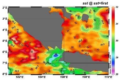
3 The method used is the assimilation of the modeling result by using the Ocean Data View 4 software for spatial variability which analyzed by descriptive and statistic using correlation to find out the influence of ENSO on the Sea Surface Temperatures against different parts of the North and the South of Sunda Strait using Minitab statistical software 16. SPL data and chlorophyll-a were gained using MODIS image recording in March, April, and May of the year The image data processed using the Ocean Data View 4 and SeaDas 7.4. The coordinates point when cropping the image were from 2⁰ North; 100⁰ West; 8 ⁰ South; 110⁰ East. Fig. 1. Location of Research. 3 Result and Discussion 3.1 Distribution of Sea Surface Temperature 3
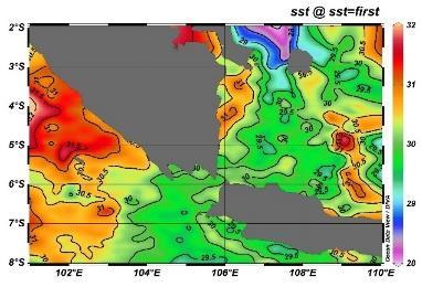
4 (a) (b) 4
 has been changed. Surface temperature in March (Figure 2.")
5 Fig. 2. Spatial distribution of Sea Surface Temperature 2015 in the Sunda Strait (a) March, (b) April, (c) May. The results of the analysis show the temperature in March, April and May 2015 through the image (2a-c) has been changed. Surface temperature in March (Figure 2.a) shows the presence of mixing temperature on the northern part of the Sunda Strait ranges from ⁰C in territorial waters near the Karimata Strait. The sea surface temperature on Sunda Strait which located between Java and Sumatra island have same tend to be stable until Hindia Ocean valued 30⁰C (Figure 2.a). On April 2015 (Figure 2.b) the waters of the southern part of tend to increase from March 2015, the magnitude of temperature in South of Sumatra sea range between 30⁰ C 31.5⁰ C, in general, the water s temperature is normal. In Figure 2.c May 2015 showed a lower temperature difference i.e. amounting to 29.5 ⁰C in both parts the waters spread out equally were the North and the South is relatively the same. (c) 5
")
6 3.2 Distribution of Chlorophyll- a (a) (b) 6
7 Fig.3. Spatial distribution of chlorophyll-a in 2015 the Sunda Strait (a) March, (b) April, (c) May (c) In Figure 3.a looks that chlorophyll in March in the northern part of the Sunda Strait has chlorophyll range mg/m³ and the southern part of the Sunda Strait has the value ranges of chlorophyll mg/m³. In Figure 3.b looks that chlorophyll in April in the northern part of the Sunda Strait has chlorophyll range 1-6 mg/m³ and the Southern part of the Sunda Strait has the value ranges of chlorophyll mg/m³. In Figure 3.c look that chlorophyll in May has increased from the previous month, in the northern part of the Sunda Strait has chlorophyll range mg/m³ and the southern part of the Sunda Strait has the value ranges of chlorophyll mg/m³. 3.3 The Correlation Between Sea Surface Temperature With SOI Table 1. Pearson correlation Sea Surface Temperature between with SOI. Pearson correlation of SST and SOI P-Value Based on the coefficient of the correlation between sea surface temperatures with SOI years 2015 of positive relationships with directions as well as the level of the relationship is very strong. The value of the p-value of the year 2011 of which is greater than 0.05, so it can be said that there is no significant correlation in 2015 between sea surface temperatures with the SOI. The correlation between sea surface temperature by SOI in the year 2015 indicates the direction of the relationship is positive, so the temperature of the sea surface with the SOI has value and the same direction. Sea surface temperature and SOI in the year 2015 decline. 7
8 3.4 The Correlation Chlorophyll- a With SOI Table 2. Pearson correlation Chlorophyll-a between with SOI. Pearson correlation of CHL-A and SOI P-Value Based on the coefficient of correlation between Chlorophyll- a with SOI year 2015 of negative relationships with directions as well as the level of strong relationships. The value of the p-value of the year 2011 of which is greater than 0.05, so it can be said that there is no significant correlation in the year 2015 with Chlorophyll- a between SOI. Correlation with Chlorophyll- a SOI in the year 2015 indicates the direction of the relationship is negative, so the Chlorophyll- a with SOI has value and opposite direction. If the value of the Chlorophyll- a is an increase, then the value of the SOI will go down. If the value of the Chlorophyll- a has decreased, then the value of the SOI will rise. On the territory of the western part of Sumatra occurred high differences in temperature with the southern part near the island of Java. The high temperature in the western part of Sumatra occurred due to the influence of the monsoon. There is a relationship between the variability of monsoon and sea surface temperature [11]. Both North and South area of Sunda Straits to Karimata straits were the warmest month phenomenon and a lower temperature difference indicating the presence of upwelling [10]. The highest temperature areas exist in the territorial waters of Karimata Strait with temperature 30⁰C state occurs due to the input of warm water from the river which modified before gets the mass output from the ITF (Indonesian Throughflow) [12]. Spatial distribution of chlorophyll in March, April and may seem that chlorophyll concentration values in the northern part of the Sunda Strait relative high in this case because the coastal areas located around the estuary of the Musi River, which resulted in a sufficient intake of nutrient substances the height of land. It is also reinforced by [13] the spread of chlorophyll-a concentration, in general, is relatively lower in the central part of the waters and the ever increasing towards the coastal waters. Movement of water masses to the East is causing the vacancy and will be replaced by water masses from a lower layer which contain cooler nutrient-rich. According to [14], stating that the concentration of chlorophyll-a can be caused by a high occurrence of nutrient-enriched on the surface layer of the waters through the various processes of the dynamics of water masses, including upwelling, vertical mixing of water masses and the mass movement of water. Spatial distribution of chlorophyll on March, April and may seem that chlorophyll concentration value in the South of Sunda Strait relative low. This was a result of low water masses input in South of Sunda Strait which contains high nutrients from the coastal. On the Southwestern part of Java, the concentration of chlorophyll-a height that occurred in the East and the transition Seasons II is caused by the occurrence of upwelling along the southern coast of Java, at a time when Southeast Monsoon [15]. 8
9 CONCLUSION The pattern of sea surface temperature distribution from Northern to Southern of Sunda Strait showed in this area affected by El Nino so that the temperature is cooler. The results showed that the distribution of chlorophyll-a in Northen Sunda Strait is not affected by El Nino but comes from the mouth of the Musi River. The relationship between chlorophyll-a with SOI has a negative moderate correlation (-0.532), indicating that chlorophyll-a in this waters have the direction opposite to SOI in contrast to the relationship between sea surface temperature with SOI which has a strong positive correlation (of 0.959). 9
10 Reference 1. J.T. Potemra, P.W. Hacker, O. Melnichenko, and N. Maximenko. J. G. Satellite estimate of freshwater exchange between the Indonesian Seas and the Indian Ocean via the Sunda Strait, 121, (2016). 2. P.K. Weyl. Oceanography. An Introduction to The Marine Environment. John Wiley & Sons Inc. New York (1970). 3. C.A.M. King. Introduction to Coastal Oceanography. McGrow Hill. New York (1963). 4. Zhao, Hui. and Ling Tang. J. G. Effect of 1998 El Nino on the distribution of phytoplankton. 112 (2007) 5. Nybakken, J.W. Biologi Laut: Suatu Pendekatan Ekologis. Gramedia. Jakarta (1992) 6. H. V. Sverdrup, M. Johnson and R. H. Fleming. The Oceans, Their Physics, Chemistry and General Biology. Prentice-Hall Inc. New York, NY (1942) 7. Z. Sitompul and E. Nurjani. J.B.I. Pengaruh El Nino Southern Oscillation (ENSO) terhadap Curah Hujan Musiman dan Tahunan di Indonesia. 2, 1 (2013). 8. E. Aldrian, Meteorologi Laut Indonesia. Jakarta : Badan Meteorologi dan Geofisika (2008). 9. K. E, Trenberth, and J. M. Caron. J. C. The Southern Oscillation Revisited: Sea Level Pressures, Surface Temperatures and Precipitation. 13, (2000). 10. D W. Kusuma Murdinanto, A. Aden, L Y. Sukresno B, Jatisworo D. Hanintyo R. IOP Conference Series: Earth and Environmental Science 98 (2017) 11. Z. Kunarso, M. Ario, M. Raden, P. Bayu, Harmon. IOP conf. Series: Earth and Environmental Science. Impact of Monsoon to Aquatic Productivity and Fish Landing at Pesarawan Regency waters. 116 (2017). 12. R. Susanto, D. Zexun, Wei, R. T. Adi, Fan Bin, Li Suhijang, Fang Guohong. Acta Oceanol. Sin. Observations of the Karimata Strait througflow from December 2007 to November , 1-6 (2013). 13. B. Nababan, K. Simamora. J.I.T.K.T. Variability Of Chlorophyll-A Concentration And Sea Surface Temperature Of Natuna Waters. 4 (2012). 14. D. J, Pugesehan. J. Agroforestri. Analisis Klorofil-A Fitoplankton (Produktivitas Primer) di Perairan Pantai Netsepa Kabupaten Maluku Tengah. Politeknik Perdamaian Halmahera. Tobelo. 4, (2010). 10
11 15. R. D. Susanto, A. L. Gordon, Q. Zheng. Upwelling along the coasts of Java and Sumatra and its Relation to ENSO. Geophysical Research Letters, 28, (2001). 11
OCN 201 Lab Fall 2009 OCN 201. Lab 9 - El Niño
 OCN 201 Lab Fall 2009 OCN 201 Lab 9 - El Niño El Niño is probably one of the most widely publicized oceanic phenomena. If there s one single reason for that it s probably the fact that El Niño s presence
Modification of the Stratification and Velocity Profile within the Straits and Seas of the Indonesian Archipelago
 DISTRIBUTION STATEMENT A. Approved for public release; distribution is unlimited. Modification of the Stratification and Velocity Profile within the Straits and Seas of the Indonesian Archipelago Amy Ffield
Your web browser (Safari 7) is out of date. For more security, comfort and the best experience on this site: Update your browser Ignore
 is out of date. For more security, comfort and the best experience on this site: Update your browser Ignore") Your web browser (Safari 7) is out of date. For more security, comfort and the best experience on this site: Update your browser Ignore L A NIÑA El Niño-Southern Oscillation (ENSO) For the complete encyclopedic
Your web browser (Safari 7) is out of date. For more security, comfort and the best experience on this site: Update your browser Ignore L A NIÑA El Niño-Southern Oscillation (ENSO) For the complete encyclopedic
ENSO Wrap-Up. Current state of the Pacific and Indian Ocean
 18-11-2014 ENSO Wrap-Up Current state of the Pacific and Indian Ocean Tropical Pacific Ocean moves closer to El Niño The Pacific Ocean has shown some renewed signs of El Niño development in recent weeks.
Lecture 13 El Niño/La Niña Ocean-Atmosphere Interaction. Idealized 3-Cell Model of Wind Patterns on a Rotating Earth. Previous Lecture!
 Lecture 13 El Niño/La Niña Ocean-Atmosphere Interaction Previous Lecture! Global Winds General Circulation of winds at the surface and aloft Polar Jet Stream Subtropical Jet Stream Monsoons 1 2 Radiation
Lecture 13. Global Wind Patterns and the Oceans EOM
 Lecture 13. Global Wind Patterns and the Oceans EOM Global Wind Patterns and the Oceans Drag from wind exerts a force called wind stress on the ocean surface in the direction of the wind. The currents
Currents. History. Pressure Cells 3/13/17. El Nino Southern Oscillation ENSO. Teleconnections and Oscillations. Neutral Conditions
 Teleconnections and Oscillations Teleconnection climate anomalies being related to each other over a large scale Oscillations: Macroscale movement of atmospheric systems that can influence weather, climate,
GEOS 201 Lab 13 Climate of Change InTeGrate Module Case studies 2.2 & 3.1
 Discerning Patterns: Does the North Atlantic oscillate? Climate variability, or short term climate change, can wreak havoc around the world. Dramatic year to year shifts in weather can have unanticipated
Variability in the tropical oceans - Monitoring and prediction of El Niño and La Niña -
 Variability in the tropical oceans - Monitoring and prediction of El Niño and La Niña - Jun ichi HIROSAWA Climate Prediction Division Japan Meteorological Agency SST anomaly in Nov. 1997 1 ( ) Outline
Equatorial upwelling. Example of regional winds of small scale
 Example of regional winds of small scale Sea and land breezes Note on Fig. 8.11. Shows the case for southern hemisphere! Coastal upwelling and downwelling. Upwelling is caused by along shore winds, that
ENSO: El Niño Southern Oscillation
 ENSO: El Niño Southern Oscillation La Niña the little girl El Niño the little boy, the child LO: explain a complete ENSO cycle and assess the net affects on fish recruitment John K. Horne University of
El Niño Lecture Notes
 El Niño Lecture Notes There is a huge link between the atmosphere & ocean. The oceans influence the atmosphere to affect climate, but the atmosphere also influences the ocean, which can also affect climate.
Ocean Circulation, Food Webs and Climate What does the wind have to do with feeding fish (and feeding us)?
?") Ocean Circulation, Food Webs and Climate What does the wind have to do with feeding fish (and feeding us)? El Niño: Tropical Oceans and Global Climate Reading: 9.10-9.13, 9.15 Graphic: Upwelling off Cape
Ocean Circulation, Food Webs and Climate What does the wind have to do with feeding fish (and feeding us)? El Niño: Tropical Oceans and Global Climate Reading: 9.10-9.13, 9.15 Graphic: Upwelling off Cape
Ocean color data for Sardinella lemuru management in Bali Strait
 Ocean color data for Sardinella lemuru management in Bali Strait Jonson Lumban Gaol 1, B. P. Pasaribu 1, K. Mahapatra 2, Y. Okada and T. Osawa 3 1 Department of Marine Science and Technology Bogor Agriculture
Overview. Learning Goals. Prior Knowledge. UWHS Climate Science. Grade Level Time Required Part I 30 minutes Part II 2+ hours Part III
 Draft 2/2014 UWHS Climate Science Unit 3: Natural Variability Chapter 5 in Kump et al Nancy Flowers Overview This module provides a hands-on learning experience where students will analyze sea surface
Data Analysis of the Seasonal Variation of the Java Upwelling System and Its Representation in CMIP5 Models
 Data Analysis of the Seasonal Variation of the Java Upwelling System and Its Representation in CMIP5 Models Iulia-Mădălina Ștreangă University of Edinburgh University of Tokyo Research Internship Program
Climate-Ocean Variability, Fisheries and Coastal Response in Indonesian waters
 Climate-Ocean Variability, Fisheries and Coastal Response in Indonesian waters Jonson Lumban-Gaol 1, Stefano Vignudelli 2 and Takahiro Osawa 3 1 Department of Marine Science and Technology Bogor Agriculture
The Child. Mean Annual SST Cycle 11/19/12
 Introduction to Climatology GEOGRAPHY 300 El Niño-Southern Oscillation Tom Giambelluca University of Hawai i at Mānoa and Pacific Decadal Oscillation ENSO: El Niño-Southern Oscillation PDO: Pacific Decadal
Lecture 24. El Nino Southern Oscillation (ENSO) Part 1
 Part 1") Lecture 24 El Nino Southern Oscillation (ENSO) Part 1 The most dominant phenomenon in the interannual variation of the tropical oceanatmosphere system is the El Nino Southern Oscillation (ENSO) over the
Lecture 24 El Nino Southern Oscillation (ENSO) Part 1 The most dominant phenomenon in the interannual variation of the tropical oceanatmosphere system is the El Nino Southern Oscillation (ENSO) over the
The General Circulation and El Niño. Dr. Christopher M. Godfrey University of North Carolina at Asheville
 The General Circulation and El Niño Dr. Christopher M. Godfrey University of North Carolina at Asheville Global Circulation Model Air flow broken up into 3 cells Easterlies in the tropics (trade winds)
Introduction to Oceanography OCE 1001
 Introduction to Oceanography OCE 1001 Lecture Notes Chantale Bégin & Jessica Fry Version 2.1 10. Ocean Circulation (Trujillo, Chapter 7) Major ocean currents are stable and predictable; they have been
Effect of sea surface temperature on monsoon rainfall in a coastal region of India
 Loughborough University Institutional Repository Effect of sea surface temperature on monsoon rainfall in a coastal region of India This item was submitted to Loughborough University's Institutional Repository
Section 6. The Surface Circulation of the Ocean. What Do You See? Think About It. Investigate. Learning Outcomes
 Chapter 5 Winds, Oceans, Weather, and Climate Section 6 The Surface Circulation of the Ocean What Do You See? Learning Outcomes In this section, you will Understand the general paths of surface ocean currents.
Ocean Inter-annual Variability: El Niño and La Niña. How does El Niño influence the oceans and climate patterns?
 Name: Date: Guiding Question: Ocean Inter-annual Variability: El Niño and La Niña How does El Niño influence the oceans and climate patterns? Introduction What is El Niño/La Niña? The El Niño/La Niña cycle
Analysis of 2012 Indian Ocean Dipole Behavior
 Analysis of 2012 Indian Ocean Dipole Behavior Mo Lan National University of Singapore Supervisor: Tomoki TOZUKA Department of Earth and Planetary Science, University of Tokyo Abstract The Indian Ocean
The influence of ocean dynamics and climate changes on the Lemuru (Bali Sardinella) abundance in the Bali Strait, Indonesia
 abundance in the Bali Strait, Indonesia") The influence of ocean dynamics and climate changes on the Lemuru (Bali Sardinella) abundance in the Bali Strait, Indonesia Mu>ara Rachmat Putri 1 Agus Se>awan 2 1 Research Group of Oceanography, Ins>tute
The influence of ocean dynamics and climate changes on the Lemuru (Bali Sardinella) abundance in the Bali Strait, Indonesia Mu>ara Rachmat Putri 1 Agus Se>awan 2 1 Research Group of Oceanography, Ins>tute
Trade winds How do they affect the tropical oceans? 10/9/13. Take away concepts and ideas. El Niño - Southern Oscillation (ENSO)
") El Niño - Southern Oscillation (ENSO) Ocean-atmosphere interactions Take away concepts and ideas What is El Niño, La Niña? Trade wind and Walker circulation. What is the Southern Oscillation? Tropical
El Niño - Southern Oscillation (ENSO) Ocean-atmosphere interactions Take away concepts and ideas What is El Niño, La Niña? Trade wind and Walker circulation. What is the Southern Oscillation? Tropical
Surface chlorophyll bloom in the Southeastern Tropical Indian Ocean during boreal summer-fall as reveal in the MODIS dataset
 Surface chlorophyll bloom in the Southeastern Tropical Indian Ocean during boreal summer-fall as reveal in the MODIS dataset Iskhaq Iskandar 1 and Bruce Monger 2 1 Jurusan Fisika, Fakultas MIPA, Universitas
Climatic and marine environmental variations associated with fishing conditions of tuna species in the Indian Ocean
 Climatic and marine environmental variations associated with fishing conditions of tuna species in the Indian Ocean Kuo-Wei Lan and Ming-An Lee Department of Environmental Biology and Fisheries Science,
CHAPTER 7 Ocean Circulation
 1 2 3 4 5 6 7 8 9 10 11 12 13 14 CHAPTER 7 Ocean Circulation Words Ocean currents Moving seawater Surface ocean currents Transfer heat from warmer to cooler areas Similar to pattern of major wind belts
Weather drivers in South Australia
 August 2008 Key facts Weather drivers in South Australia Major weather drivers in South Australia are: El Niño - Southern Oscillation frontal systems cut-off lows blocking highs Indian Ocean Dipole cloudbands
March 4 th, 2019 Sample Current Affairs
 March 4 th, 2019 Sample Current Affairs 1. A weak El Niño is developing in the equatorial Pacific Ocean, which is expected to continue for a few months at least. What is El Nino? What causes El Nino? What
Climatic and marine environmental variations associated with fishing conditions of tuna species in the Indian Ocean
 Climatic and marine environmental variations associated with fishing conditions of tuna species in the Indian Ocean Kuo-Wei Lan and Ming-An Lee Department of Environmental Biology and Fisheries Science,
El Niño / Southern Oscillation (ENSO) and inter-annual climate variability
 and inter-annual climate variability") El Niño / Southern Oscillation (ENSO) and inter-annual climate variability seasonal cycle what is normal? monthly average conditions through a calendar year sea level pressure and surface winds surface
El Niño / Southern Oscillation (ENSO) and inter-annual climate variability seasonal cycle what is normal? monthly average conditions through a calendar year sea level pressure and surface winds surface
Upwelling Variability along the Southern Coast of Bali and in Nusa Tenggara Waters
 Ocean Sci. J. (2013) 48(1):49-57 http://dx.doi.org/10.1007/s12601-013-0004-3 Available online at http://link.springer.com Article Upwelling Variability along the Southern Coast of Bali and in Nusa Tenggara
IX. Upper Ocean Circulation
 IX. Upper Ocean Circulation World Ocean Covers 71% of Earth s surface Contains 97% of surface water Arctic Ocean NH: 61% ocean, 39% land Pacific Ocean Atlantic Ocean Southern Ocean Indian Ocean SH: 81%
3/22/11. General Circulation of the Atmosphere. General Circulation of the Atmosphere
 Chapter 10 General refers to the average air flow, actual winds will vary considerably. Average conditions help identify driving forces. The basic cause of the general circulation is unequal heating of
Review for the second quarter. Mechanisms for cloud formation
 Review for the second quarter Mechanisms for cloud formation 1 Rising air expands and cools; Sinking air compresses and warms. (18) (24) Dry adiabatic lapse rate (10 o C/km): the rate of temperature decrease
PROC. ITB Eng. Science Vol. 36 B, No. 2, 2004,
 PROC. ITB Eng. Science Vol. 36 B, No. 2, 2004, 133-139 133 Semiannual Kelvin Waves Propagation along the South Coast of Sumatra-Jawa-Bali and the Lesser Sunda Islands Observed by TOPEX/POSEIDON and ERS-1/2
Chapter 10: Global Wind Systems
 Chapter 10: Global Wind Systems Three-cell model of atmospheric circulation Intertropical Convergence Zone (ITCZ) Typical surface wind patterns Upper-level pressure and winds Climatological sea-level pressure
Module 3, Investigation 1: Briefing 1 What are the effects of ENSO?
 Background The changing temperatures of the tropical Pacific Ocean affect climate variability all over Earth. Ocean warming and cooling dramatically affect human activities by changing weather patterns
Indian Ocean Dipole - ENSO - monsoon connections and Overcoming coupled model systematic errors
 Indian Ocean Dipole - ENSO - monsoon connections and Overcoming coupled model systematic errors Hilary Spencer, Rowan Sutton and Julia Slingo CGAM, Reading University h.spencer@reading.ac.uk Monsoon -
Tropical Pacific Ocean remains on track for El Niño in 2014
 1 of 10 3/06/2014 3:33 PM ENSO Wrap-Up Current state of the Pacific and Indian Ocean Tropical Pacific Ocean remains on track for El Niño in 2014 Issued on Tuesday 3 June 2014 Product Code IDCKGEWWOO The
General Introduction to Climate Drivers and BoM Climate Services Products
 General Introduction to Climate Drivers and BoM Climate Services Products Climate Information Services Australian Bureau of Meteorology Yuriy Kuleshov El Niño Southern Oscillation (ENSO) El Niño Southern
Weather drivers in Victoria
 August 2008 Weather drivers in Victoria Key facts Major weather drivers in Victoria are: El Niño - Southern Oscillation frontal systems cut-off lows blocking highs Southern Annular Mode cloudbands Figure
Wind Driven Circulation Indian Ocean and Southern Ocean
 Wind Driven Circulation Indian Ocean and Southern Ocean Lecture 18 MAR 350 Spring 2017 Reading: Knauss Chapter 7 ECCO2 model animation ecco2_sst_flow (2).mp4 Mean surface height and currents DPO Fig. 11.1
Monitoring and prediction of El Niño and La Niña
 Monitoring and prediction of El Niño and La Niña Akio NARUI El Niño Monitoring and Prediction Group Climate Prediction Division Japan Meteorological Agency Outline 1. Introduction of El Niño and La Niña
Climate Variability OCEA 101
 Climate Variability OCEA 101 Why should you care? - the associated atmospheric and oceanic changes accompanying climate variability yield significant changes in the distribution of nutrients and marine
REMINDERS: UPCOMING REVIEW SESSIONS: - Thursday, Feb 27, 6:30-8:00pm in HSS 1330
 REMINDERS: Midterm 2: Friday, February 28 - lecture material covering chapters 6, 7, and 15 (since first midterm and through Wed lecture) - same Format as first midterm UPCOMING REVIEW SESSIONS: - Thursday,
Available online at ScienceDirect. Procedia Environmental Sciences 33 (2016 )
") Available online at www.sciencedirect.com ScienceDirect Procedia Environmental Sciences 33 (2016 ) 583 599 The 2 nd International Symposium on LAPAN-IPB Satellite for Food Security and Environmental Monitoring
Available online at www.sciencedirect.com ScienceDirect Procedia Environmental Sciences 33 (2016 ) 583 599 The 2 nd International Symposium on LAPAN-IPB Satellite for Food Security and Environmental Monitoring
Lecture 29. The El-Niño Southern Oscillation (ENSO) La Niña = the girl; corresponds to the opposite climate situation
 La Niña = the girl; corresponds to the opposite climate situation") Lecture 29 The El-Niño Southern Oscillation (ENSO) El Niño is Spanish for Christ child, the name given by fishermen to a warm ocean current off the coast of Peru/Ecuador that in some years occurs near
Lecture 29 The El-Niño Southern Oscillation (ENSO) El Niño is Spanish for Christ child, the name given by fishermen to a warm ocean current off the coast of Peru/Ecuador that in some years occurs near
Global Circulations. GEOG/ENST 2331 Lecture 15 Ahrens: Chapter 10
 Global Circulations GEOG/ENST 2331 Lecture 15 Ahrens: Chapter 10 Last lecture Microscale (turbulence) Mesoscale (land/sea breeze) Synoptic scale (monsoon) Global scale (3 cell circulation) Three Cell Model
- terminology. Further Reading: Chapter 07 of the text book. Outline. - characteristics of ENSO. -impacts
 (1 of 14) Further Reading: Chapter 07 of the text book Outline - terminology - characteristics of ENSO -impacts (2 of 14) Today: Introduction We want to look at another source of variability in the atmosphere
Ocean Currents that Redistribute Heat Globally
 Ocean Currents that Redistribute Heat Globally Ocean Circulation Ocean Currents Fig. CO7 OCEAN CURRENTS Surface ocean currents are similar to wind patterns: 1. Driven by Coriolis forces 2. Driven by winds
Monday, October 2, Watch for new assessment (Week 4/5 review) TA s have your tests, please see key (at course website)
 TA s have your tests, please see key (at course website)") Monday, October 2, 2017 Watch for new assessment (Week 4/5 review) TA s have your tests, please see key (at course website) Homework 3 Due date Wednesday, Oct 11 (8 pm) Be ready to watch another important
Monday, October 2, 2017 Watch for new assessment (Week 4/5 review) TA s have your tests, please see key (at course website) Homework 3 Due date Wednesday, Oct 11 (8 pm) Be ready to watch another important
Leeuwin Current - Reading
 Leeuwin Current At 5,500 kilometres, the Leeuwin is our longest ocean current! One of Australia s most influential natural features, the Leeuwin Current, has been confirmed as the longest continuous coastal
Onset, active and break periods of the Australian monsoon
 IOP Conference Series: Earth and Environmental Science Onset, active and break periods of the Australian monsoon To cite this article: Hakeem A Shaik and Samuel J Cleland 2010 IOP Conf. Ser.: Earth Environ.
The Air-Sea Interaction. Masanori Konda Kyoto University
 2 The Air-Sea Interaction Masanori Konda Kyoto University 2.1 Feedback between Ocean and Atmosphere Heat and momentum exchange between the ocean and atmosphere Atmospheric circulation Condensation heat
The Movement of Ocean Water. Currents
 The Movement of Ocean Water Currents Ocean Current movement of ocean water that follows a regular pattern influenced by: weather Earth s rotation position of continents Surface current horizontal movement
ENFEN OFFICIAL STATEMENT N Status Warning System: El Niño Coastal Alert 1
 ENFEN OFFICIAL STATEMENT N 21-2015 Status Warning System: El Niño Coastal Alert 1 Note: This translation is provided for convenience, the official version is in Spanish The Multisectoral Committee of the
ESCI 485 Air/sea Interaction Lesson 9 Equatorial Adjustment and El Nino Dr. DeCaria
 ESCI 485 Air/sea Interaction Lesson 9 Equatorial Adjustment and El Nino Dr. DeCaria Reference: El Nino, La Nina, and the Southern Oscillation, Philander THE TWO-LAYER SHALLOW WATER MODEL The ocean can
(20 points) 1. ENSO is a coupled climate phenomenon in the tropical Pacific that has both regional and global impacts.
 1. ENSO is a coupled climate phenomenon in the tropical Pacific that has both regional and global impacts.") SIO 210 Problem Set 4 Answer key December 1, 2014 Due Dec. 12, 2014 (20 points) 1. ENSO is a coupled climate phenomenon in the tropical Pacific that has both regional and global impacts. (2 points) a)
SIO 210 Problem Set 4 Answer key December 1, 2014 Due Dec. 12, 2014 (20 points) 1. ENSO is a coupled climate phenomenon in the tropical Pacific that has both regional and global impacts. (2 points) a)
Global Impacts of El Niño on Agriculture
 Global Impacts of El Niño on Agriculture Presented to the University of Arkansas Division of Agriculture s Food and Agribusiness Series Webinar Series Presented by: Mark Brusberg and Brian Morris USDA
How fast will be the phase-transition of 15/16 El Nino?
 How fast will be the phase-transition of 15/16 El Nino? YOO-GEUN HAM D E P A R T M E N T O F O C E A N O G R A P H Y, C H O N N A M N A T I O N A L U N I V E R S I T Y 2015/16 El Nino outlook One of strongest
ENSO Cycle: Recent Evolution, Current Status and Predictions. Update prepared by Climate Prediction Center / NCEP 4 September 2012
 ENSO Cycle: Recent Evolution, Current Status and Predictions Update prepared by Climate Prediction Center / NCEP 4 September 2012 Outline Overview Recent Evolution and Current Conditions Oceanic Niño Index
ORESU-G ORESU-G
 ORESU-G-97-008 ORESU-G 97-008 The Pacific Northwest: a Region of Transitions The unusual oceanic and atmospheric conditions of the Pacific Northwest create a remarkable and dynamic setting unlike any other
Climate variability and changes in the marginal Far-Eastern Seas
 PICES-26 November 2-3, 26 San Diego, USA Climate variability and changes in the marginal Far-Eastern Seas Elena I. Ustinova and Yury D. Sorokin Pacific Fisheries Research Centre (TINRO-Centre) 699 Shevchenko
Current: large mass of continuously moving ocean water
 Ocean Currents Current: large mass of continuously moving ocean water Surface Currents--Wind Circulation These waters make up about 10% of all the water in the ocean. These waters are the upper 400 meters
Indian Ocean warming its extent, and impact on the monsoon and marine productivity
 Indian Ocean warming its extent, and impact on the monsoon and marine productivity RIO WIO Indian Ocean warming: o Western Indian Ocean experienced strong, monotonous warming during the last century o
9/25/2014. Scales of Atmospheric Motion. Scales of Atmospheric Motion. Chapter 7: Circulation of the Atmosphere
 Chapter 7: Circulation of the Atmosphere The Atmosphere: An Introduction to Meteorology, 12 th Lutgens Tarbuck Lectures by: Heather Gallacher, Cleveland State University Scales of Atmospheric Motion Small-
The Local Characteristics of Indonesian Seas and Its Possible Connection with ENSO and IOD: Ten Years Analysis of Satellite Remote Sensing Data
 Earth Science Research; Vol. 2, No. 2; 2013 ISSN 1927-0542 E-ISSN 1927-0550 Published by Canadian Center of Science and Education The Local Characteristics of Indonesian Seas and Its Possible Connection
Effect of late 1970 s Climate Shift on Interannual Variability of Indian Summer Monsoon Associated with TBO
 Effect of late 97 s Climate Shift on Interannual Variability of Indian Summer Monsoon Associated with TBO 7. Introduction Biennial variability has been identified as one of the major modes of interannual
Class Notes: Week 10. April 9 th,2019. Topics: Front and Mid-Latitude Wave Cyclones El Niño / La Niña Mid-term 2 review
 Class Notes: Week 10 April 9 th,2019 Topics: Front and Mid-Latitude Wave Cyclones El Niño / La Niña Mid-term 2 review Front- is a boundary between 2 different types of air masses Air masses with different
Outline. 1 Background Introduction. 3 SST Amphidrome 4 Niño Pipe 5. SST in China Seas. Seasonality Spiral. Eddy Tracking. Concluding Remarks
 GHRSST XVIII Outline 1 Background Introduction 2 SST in China Seas 3 SST Amphidrome 4 Niño Pipe 5 Seasonality Spiral 5 stories in S(S)T oceanography 6 7 Eddy Tracking Concluding Remarks 2 Welcome to a
Origin of Inter-model uncertainty in ENSO amplitude change
 Origin of Inter-model uncertainty in ENSO amplitude change Shang-Ping Xie Scripps Institution of Oceanography, UCSD Zheng, X.T., S.-P. Xie, L.H. Lv, and Z.Q. Zhou, 2016: Intermodel uncertainty in ENSO
Name: OBJECTIVES: By the end of today s lesson, you will be able to
 7 th Grade Science Unit: Water s Cycles and Patterns Lesson: WCP 21 Name: Date: Monday, October 3, 2016 Homeroom: _ OBJECTIVES: By the end of today s lesson, you will be able to SWBAT Explain how currents
Appendix E Mangaone Stream at Ratanui Hydrological Gauging Station Influence of IPO on Stream Flow
 NZ Transport Agency Peka Peka to North Ōtaki Expressway Hydraulic Investigations for Expressway Crossing of Mangaone Stream and Floodplain Appendix E Mangaone Stream at Ratanui Hydrological Gauging Station
Understanding El Nino-Monsoon teleconnections
 Understanding El Nino-Monsoon teleconnections Dr Neena Joseph Mani Earth & Climate Science INSA Anniversary General meeting, Session: Science in IISER Pune 27 th December 2017 Mean State of the equatorial
Influence of El Nino Southern Oscillation and Indian Ocean Dipole in biennial oscillation of Indian summer monsoon
 Influence of El Nino Southern Oscillation and Indian Ocean Dipole in biennial oscillation of Indian summer monsoon 4.1 Introduction The main contributors to the interannual variability of Indian summer
El Nino and Global Warming
 El Nino and Global Warming El Niño and Global Warming El Niño Climate Trade winds Barometric pressure Southern oscillation WHAT YOU WILL LEARN 1. You will identify the cause of El Niño events. 2. You will
ENSO Jigsaw [Key Science Knowledge Module]
![ENSO Jigsaw [Key Science Knowledge Module]](/thumbs/83/88958439.jpg "ENSO Jigsaw [Key Science Knowledge Module]") ` 3 Teacher Edition 2-3 days ENSO Jigsaw [Key Science Knowledge Module] Activity Overview This module is the most important learning module in terms of the physical science aspects associated with the
` 3 Teacher Edition 2-3 days ENSO Jigsaw [Key Science Knowledge Module] Activity Overview This module is the most important learning module in terms of the physical science aspects associated with the
The Ocean is a Geophysical Fluid Like the Atmosphere. The Physical Ocean. Yet Not Like the Atmosphere. ATS 760 Global Carbon Cycle The Physical Ocean
 The Physical Ocean The Ocean is a Geophysical Fluid Like the Atmosphere Three real forces: Gravity Pressure gradients Friction Two apparent forces: Coriolis and Centrifugal Geostrophic & Hydrostatic balances
Lecture 13 March 24, 2010, Wednesday. Atmospheric Pressure & Wind: Part 4
 Lecture 13 March 24, 2010, Wednesday Atmospheric Pressure & Wind: Part 4 Synoptic scale winds Mesoscale winds Microscale winds Air-sea interactions The largest synoptic scale wind. Monsoon: Arabic for
APPENDIX B NOAA DROUGHT ANALYSIS 29 OCTOBER 2007
 APPENDIX B NOAA DROUGHT ANALYSIS 29 OCTOBER 2007 ENSO Cycle: Recent Evolution, Current Status and Predictions Update prepared by Climate Prediction Center / NCEP October 29, 2007 Outline Overview Recent
OCEANOGRAPHY STUDY GUIDE
 OCEANOGRAPHY STUDY GUIDE Chapter 2 Section 1 1. Most abundant salt in ocean. Sodium chloride; NaCl 2. Amount of Earth covered by Water 71% 3. Four oceans: What are they? Atlantic, Pacific, Arctic, Indian
The study of MJO impact on wave height and wind speed in Indonesian Seas
 IOP Conference Series: Earth and Environmental Science PAPER OPEN ACCESS The study of MJO impact on wave height and wind speed in Indonesian Seas To cite this article: I Hilmi et al 2018 IOP Conf. Ser.:
ENSO IMPACT ON SST AND SLA VARIABILITY IN INDONESIA
 ENSO IMPACT ON SST AND SLA VARIABILITY IN INDONESIA Bambang Sukresno 1 1 Institute for Marine Research and Observation e-mail : Bambang_sukresno@yahoo.com ABSTRACT The observation of El Nino Southern Oscillation
WORKING PAPER SKJ 1 IMPACT OF ENSO ON SURFACE TUNA HABITAT IN THE WESTERN AND CENTRAL PACIFIC OCEAN. Patrick Lehodey
 Impact of ENSO on surface tuna habitat 1 WORKING PAPER SKJ 1 IMPACT OF ENSO ON SURFACE TUNA HABITAT IN THE WESTERN AND CENTRAL PACIFIC OCEAN Patrick Lehodey Oceanic Fisheries Programme Secretariat of the
Lecture 5.1 Surface Ocean Circulation. Image from Daily Mail Newspaper, UK
 Lecture 5.1 Surface Ocean Circulation Image from Daily Mail Newspaper, UK Announcements Midterm is Thursday, consists of 25 multiple choice, 3 pages short answer questions No Scantron needed Calculators,
El Niño Unit (2.5 pts)
") T. James Noyes, El Camino College El Niño Unit (Topic 9B) page 1 Name: Section: El Niño Unit (2.5 pts) El Niño is a warm ocean current that flows along the Equator and towards the west coast of South America
T. James Noyes, El Camino College El Niño Unit (Topic 9B) page 1 Name: Section: El Niño Unit (2.5 pts) El Niño is a warm ocean current that flows along the Equator and towards the west coast of South America
ATS150: Global Climate Change. Oceans and Climate. Icebergs. Scott Denning CSU 1
 The Oceans Wind-Driven Gyre Circulations Icebergs Scott Denning CSU 1 Surface Balance of Forces friction coriolis wind stress resultant current Wind stress accelerates surface water Friction couples surface
Lesson: Ocean Circulation
 Lesson: Ocean Circulation By Keith Meldahl Corresponding to Chapter 9: Ocean Circulation As this figure shows, there is a connection between the prevailing easterly and westerly winds (discussed in Chapter
Pacific Climate Variability
 Pacific Climate Variability Pacific Islands Climate Education Partnership You may have heard the term climate variability. What does the term climate variability mean? What are the causes and effects of
Pathways and Effects of Indonesian Throughflow water in the Indian Ocean using Trajectory and Tracer experiments in an OGCM
 Pathways and Effects of Indonesian Throughflow water in the Indian Ocean using Trajectory and Tracer experiments in an OGCM Vinu K V Ph.D Student Division of Ocean And Atmospheric Sciences, Hokkaido University,
3.1 (Read section 3.1), starts p.80
, starts p.80") 3.1 (Read section 3.1), starts p.80 Write down these definitions in your notes as you find them when you read: 1. 2. 3. 4. Climate Convection specific heat capacity weather Then turn to p 87 READING CHECK
3.1 (Read section 3.1), starts p.80 Write down these definitions in your notes as you find them when you read: 1. 2. 3. 4. Climate Convection specific heat capacity weather Then turn to p 87 READING CHECK
Ecology. Professor Andrea Garrison Biology 3A Illustrations 2014 Cengage Learning unless otherwise noted
 Ecology Professor Andrea Garrison Biology 3A Illustrations 2014 Cengage Learning unless otherwise noted Ecology Ecology (oikos = house) is the study of where an organism lives and all the interactions
Quiz name: Oceanography - Land and Sea Interaction - Quiz #2
 Name: Quiz name: Oceanography - Land and Sea Interaction - Quiz #2 ate: 1. What is the direction of spin for gyres in the northern hemisphere? clockwise counter clockwise northern oscillation southern
Winds and Ocean Circulations
 Winds and Ocean Circulations AT 351 Lab 5 February 20, 2008 Sea Surface Temperatures 1 Temperature Structure of the Ocean Ocean Currents 2 What causes ocean circulation? The direction of most ocean currents
Ocean Layers. Based on sunlight penetration: Based on water density: Sunlight (photosynthesis is possible) Twilight Midnight
 Twilight Midnight") PART 3 Ocean Layers Based on sunlight penetration: Sunlight (photosynthesis is possible) Twilight Midnight Based on water density: Mixed layer Pycnocline (rapid change of themperature/salinity) Deep ocean
PART 3 Ocean Layers Based on sunlight penetration: Sunlight (photosynthesis is possible) Twilight Midnight Based on water density: Mixed layer Pycnocline (rapid change of themperature/salinity) Deep ocean
Midterm Exam III November 25, 2:10
 Midterm Exam III November 25, 2:10 25, 2:10 3:25 pm, HW714 Chapters 7 (7.12 7.17), 8 and 9 (through section 9.15, included) 60 multiple choice questions this exam constitutes 22% (only) of your total (overall)