Chapter 4 Global Climates and Biomes
|
|
|
- Denis Rice
- 6 years ago
- Views:
Transcription

1 Chapter 4 Global Climates and Biomes
2 Global Processes Determine Weather and Climate - the short term conditions of the atmosphere in a local area. These include temperature, humidity, clouds, precipitation, wind speed and atmospheric pressure. - The average weather that occurs in a given region over a long periodtypically several decades.
3 Global Processes Determine Weather and Climate Weather- the short term conditions of the atmosphere in a local area. These include temperature, humidity, clouds, precipitation, wind speed and atmospheric pressure. - The average weather that occurs in a given region over a long periodtypically several decades.
4 Global Processes Determine Weather and Climate Weather- the short term conditions of the atmosphere in a local area. These include temperature, humidity, clouds, precipitation, wind speed and atmospheric pressure. Climate- The average weather that occurs in a given region over a long periodtypically several decades.
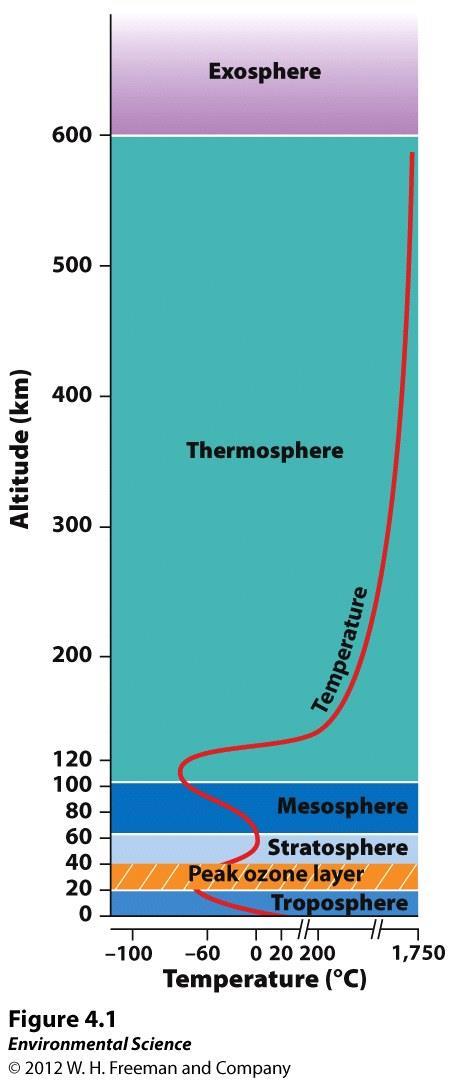
5 Earth's Atmosphere - the layer closest to Earth's surface extending roughly 16 km (10 miles) above Earth. - above the troposphere, this extends from roughly 16 to 50 km (10-31 miles).
6 Earth's Atmosphere Troposphere- the layer closest to Earth's surface extending roughly 16 km (10 miles) above Earth. - above the troposphere, this extends from roughly 16 to 50 km (10-31 miles).
7 Earth's Atmosphere Troposphere- the layer closest to Earth's surface extending roughly 16 km (10 miles) above Earth. Stratosphere- above the troposphere, this extends from roughly 16 to 50 km (10-31 miles).
8
9 Unequal Heating of Earth As the Sun's energy passes through the atmosphere and strikes land and water, it the surface of Earth. But this warming does not occur across the planet.
10 Unequal Heating of Earth As the Sun's energy passes through the atmosphere and strikes land and water, it warms the surface of Earth. But this warming does not occur across the planet.
11 Unequal Heating of Earth As the Sun's energy passes through the atmosphere and strikes land and water, it warms the surface of Earth. But this warming does not occur evenly across the planet.
12
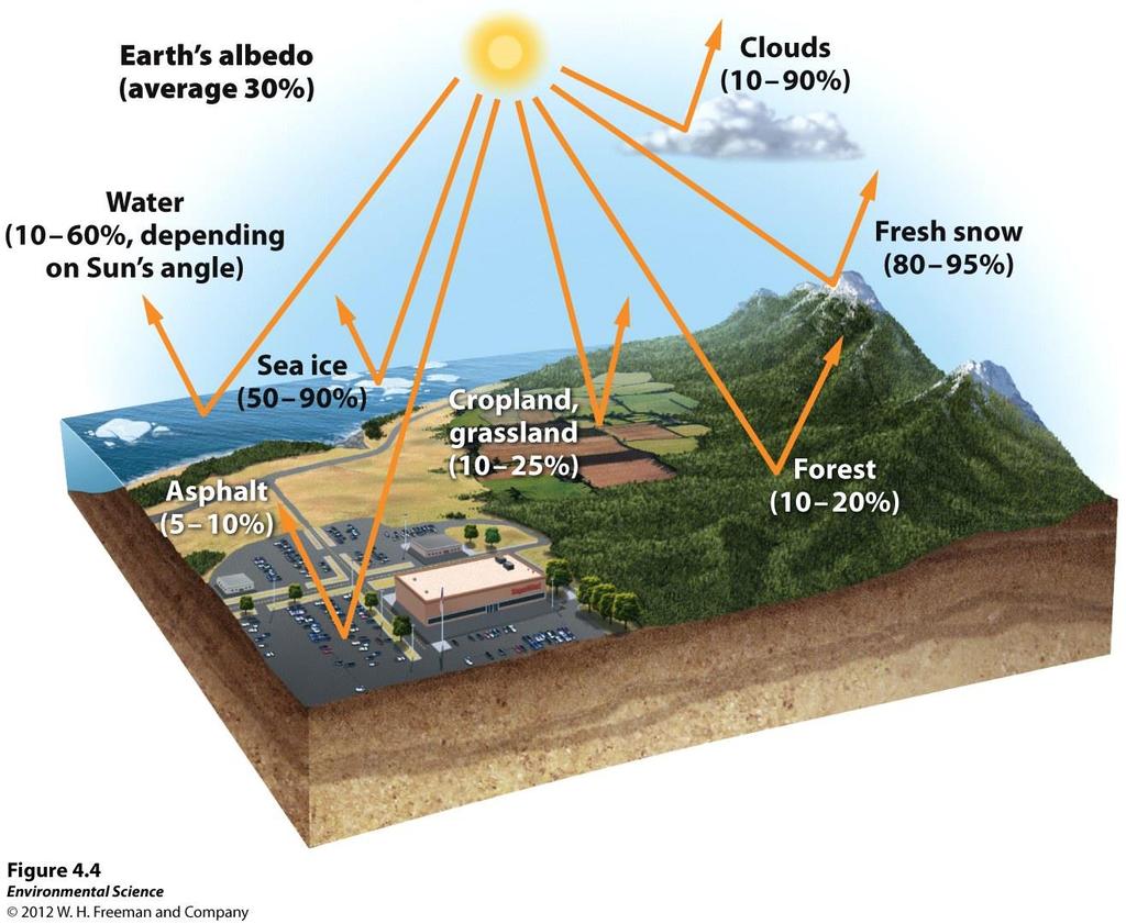
13 Unequal Heating of Earth This heating is because: The variation in at which the Sun's rays strike The amount of over which the Sun's rays are distributed Some areas of Earth reflect more solar energy than others. ( )
14 Unequal Heating of Earth This unequal heating is because: The variation in at which the Sun's rays strike The amount of over which the Sun's rays are distributed Some areas of Earth reflect more solar energy than others. ( )
15 Unequal Heating of Earth This unequal heating is because: The variation in angle at which the Sun's rays strike The amount of over which the Sun's rays are distributed Some areas of Earth reflect more solar energy than others. ( )
16 Unequal Heating of Earth This unequal heating is because: The variation in angle at which the Sun's rays strike The amount of surface area over which the Sun's rays are distributed Some areas of Earth reflect more solar energy than others. ( )
17 Unequal Heating of Earth This unequal heating is because: The variation in angle at which the Sun's rays strike The amount of surface area over which the Sun's rays are distributed Some areas of Earth reflect more solar energy than others. (Albedo)
18 Atmospheric Convection Currents Air has properties that determines its movement: 1. - less dense air rises, denser air sinks. 2. Water vapor - warm air has a higher capacity for water vapor than cold air.
19 Atmospheric Convection Currents Air has 4 properties that determines its movement: 1. - less dense air rises, denser air sinks. 2. Water vapor - warm air has a higher capacity for water vapor than cold air.
20 Atmospheric Convection Currents Air has 4 properties that determines its movement: 1. Density - less dense air rises, denser air sinks. 2. Water vapor - warm air has a higher capacity for water vapor than cold air.
21 Atmospheric Convection Currents Air has 4 properties that determines its movement: 1. Density - less dense air rises, denser air sinks. 2. Water vapor capacity- warm air has a higher capacity for water vapor than cold air.
22 Atmospheric Convection Currents Air has 4 properties that determines its movement: 3. heating or cooling- as air rises in the atmosphere its pressure decreases and the air expands. Conversely, as air sinks, the pressure increases and the air decreases in volume. 4. Latent heat - when water vapor in the atmosphere condenses into liquid water and energy is released.
23 Atmospheric Convection Currents Air has 4 properties that determines its movement: 3. Adiabatic heating or cooling- as air rises in the atmosphere its pressure decreases and the air expands. Conversely, as air sinks, the pressure increases and the air decreases in volume. 4. Latent heat - when water vapor in the atmosphere condenses into liquid water and energy is released.
24 Atmospheric Convection Currents Air has 4 properties that determines its movement: 3. Adiabatic heating or cooling- as air rises in the atmosphere its pressure decreases and the air expands. Conversely, as air sinks, the pressure increases and the air decreases in volume. 4. Latent heat release- when water vapor in the atmosphere condenses into liquid water and energy is released.

25 Formation of Convection Currents
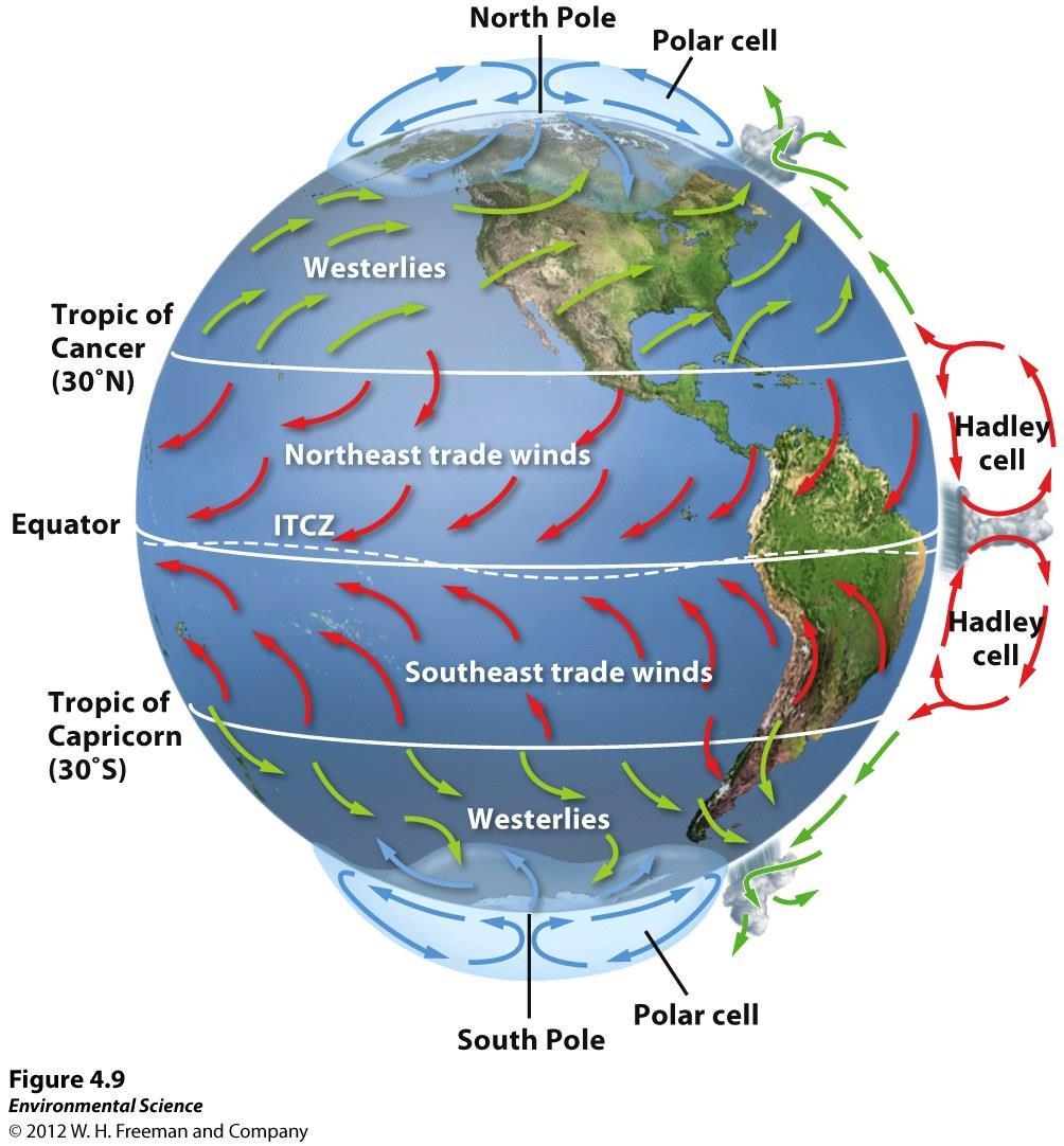
26 Formation of Convection Currents Atmospheric currents are global patterns of air movement that are initiated by the unequal heating of Earth. cells- the convection currents that cycle between the equator and 30 north and south.
27 Formation of Convection Currents Atmospheric convection currents are global patterns of air movement that are initiated by the unequal heating of Earth. cells- the convection currents that cycle between the equator and 30 north and south.
28 Formation of Convection Currents Atmospheric convection currents are global patterns of air movement that are initiated by the unequal heating of Earth. Hadley cells- the convection currents that cycle between the equator and 30 north and south.
29 Formation of Convection Currents convergencethe area of Earth that receives the most intense sunlight and where the ascending branches of the two Hadley cells converge. cells- the convection currents that are formed by air that rises at 60 north and south and sinks at the poles (90 north and south)
30 Formation of Convection Currents Intertropical convergence- the area of Earth that receives the most intense sunlight and where the ascending branches of the two Hadley cells converge. cells- the convection currents that are formed by air that rises at 60 north and south and sinks at the poles (90 north and south)
31 Formation of Convection Currents Intertropical convergence- the area of Earth that receives the most intense sunlight and where the ascending branches of the two Hadley cells converge. Polar cells- the convection currents that are formed by air that rises at 60 north and south and sinks at the poles (90 north and south)
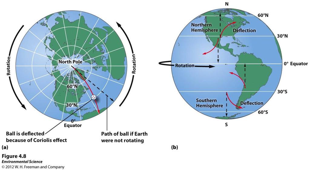
32 Earth's Rotation and the Coriolis Effect As Earth rotates, its surface moves much at the equator than in mid-latitude and polar regions. The faster rotation speeds closer to the equator cause a of objects that are moving directly north or south.
33 Earth's Rotation and the Coriolis Effect As Earth rotates, its surface moves much faster at the equator than in mid-latitude and polar regions. The faster rotation speeds closer to the equator cause a of objects that are moving directly north or south.
34 Earth's Rotation and the Coriolis Effect As Earth rotates, its surface moves much faster at the equator than in mid-latitude and polar regions. The faster rotation speeds closer to the equator cause a deflection of objects that are moving directly north or south.
35
36 Earth's Rotation and the Coriolis Effect Effect- the deflection of an object's path due to Earth's rotation. The of the world are produced by a combination of atmospheric convection currents and the Coriolis effect.
37 Earth's Rotation and the Coriolis Effect Coriolis Effect- the deflection of an object's path due to Earth's rotation. The of the world are produced by a combination of atmospheric convection currents and the Coriolis effect.
38 Earth's Rotation and the Coriolis Effect Coriolis Effect- the deflection of an object's path due to Earth's rotation. The prevailing winds of the world are produced by a combination of atmospheric convection currents and the Coriolis effect.
39
40 Earth's Tilt and the Seasons The Earth's axis of rotation is tilted. When the Northern Hemisphere is tilted the Sun, the Southern Hemisphere is away from the Sun, and vice versa.
41 Earth's Tilt and the Seasons The Earth's axis of rotation is tilted When the Northern Hemisphere is tilted the Sun, the Southern Hemisphere is away from the Sun, and vice versa.
42 Earth's Tilt and the Seasons The Earth's axis of rotation is tilted When the Northern Hemisphere is tilted toward the Sun, the Southern Hemisphere is away from the Sun, and vice versa.
43 Earth's Tilt and the Seasons The Earth's axis of rotation is tilted When the Northern Hemisphere is tilted toward the Sun, the Southern Hemisphere is tilted away from the Sun, and vice versa.
44
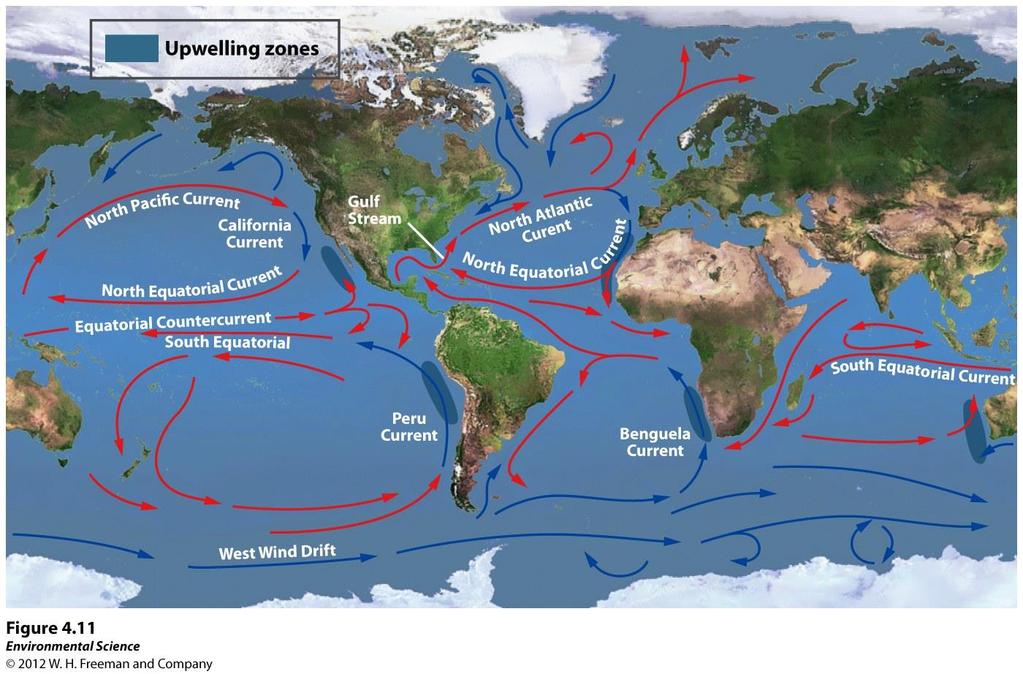
45 Ocean Currents currents are driven by a combination of temperature, gravity, prevailing winds, the Coriolis effect, and the locations of continents. Warm water, like warm air, expands and rises. - the large-scale patterns of water circulation. The ocean surface currents rotate in a direction in the Northern Hemisphere and a direction in the Southern Hemisphere.
46 Ocean Currents Ocean currents are driven by a combination of temperature, gravity, prevailing winds, the Coriolis effect, and the locations of continents. Warm water, like warm air, expands and rises. - the large-scale patterns of water circulation. The ocean surface currents rotate in a direction in the Northern Hemisphere and a direction in the Southern Hemisphere.
47 Ocean Currents Ocean currents are driven by a combination of temperature, gravity, prevailing winds, the Coriolis effect, and the locations of continents. Warm water, like warm air, expands and rises. Gyres - the large-scale patterns of water circulation. The ocean surface currents rotate in a direction in the Northern Hemisphere and a direction in the Southern Hemisphere.
48 Ocean Currents Ocean currents are driven by a combination of temperature, gravity, prevailing winds, the Coriolis effect, and the locations of continents. Warm water, like warm air, expands and rises. Gyres - the large-scale patterns of water circulation. The ocean surface currents rotate in a clockwise direction in the Northern Hemisphere and a direction in the Southern Hemisphere.
49 Ocean Currents Ocean currents are driven by a combination of temperature, gravity, prevailing winds, the Coriolis effect, and the locations of continents. Warm water, like warm air, expands and rises. Gyres - the large-scale patterns of water circulation. The ocean surface currents rotate in a clockwise direction in the Northern Hemisphere and a counterclockwise direction in the Southern Hemisphere.
50 Upwelling - as the surface currents separate from one another, deeper waters rise and replace the water that has moved away. This upward movement of water brings from the ocean bottom that supports the large populations of producers, which in turn support large populations of fish.
51 Upwelling Upwelling - as the surface currents separate from one another, deeper waters rise and replace the water that has moved away. This upward movement of water brings from the ocean bottom that supports the large populations of producers, which in turn support large populations of fish.
52 Upwelling Upwelling - as the surface currents separate from one another, deeper waters rise and replace the water that has moved away. This upward movement of water brings nutrients from the ocean bottom that supports the large populations of producers, which in turn support large populations of fish.
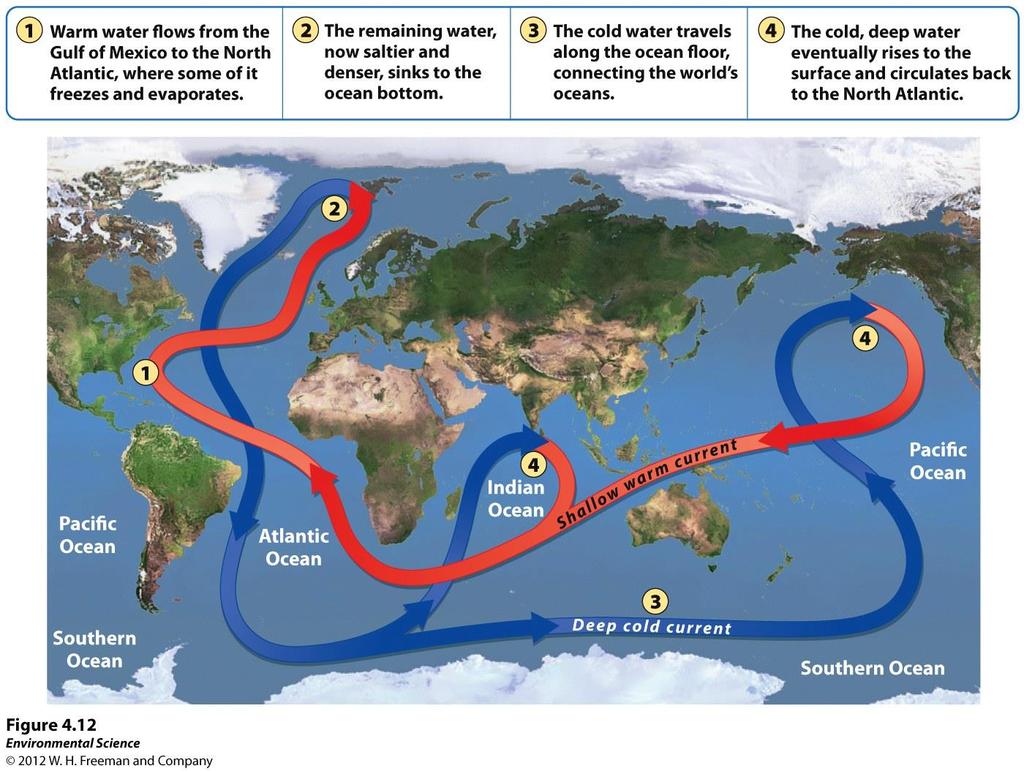
53 Thermohaline Circulation circulationanother oceanic circulation that drives the mixing of surface water and deep water. Scientists believe this process is crucial for moving heat and nutrients around the globe. Thermohaline circulation appears to be driven by surface waters that contain unusually large amounts of.
54 Thermohaline Circulation Thermohaline circulation- another oceanic circulation that drives the mixing of surface water and deep water. Scientists believe this process is crucial for moving heat and nutrients around the globe. Thermohaline circulation appears to be driven by surface waters that contain unusually large amounts of.
55 Thermohaline Circulation Thermohaline circulation- another oceanic circulation that drives the mixing of surface water and deep water. Scientists believe this process is crucial for moving heat and nutrients around the globe. Thermohaline circulation appears to be driven by surface waters that contain unusually large amounts of salt.
56 Thermohaline Circulation
57 Thermohaline Circulation Some of the water that flows from the Gulf of Mexico to the North Atlantic freezes or evaporates, and the salt that remains behind increases the salt of the water. This cold, salty water is relatively, so it sinks to the bottom of the ocean, mixing with deeper ocean waters. These two processes create the movement necessary to drive a deep, cold current that slowly moves past Antarctica and northward to the northern Pacific Ocean.
58 Thermohaline Circulation Some of the water that flows from the Gulf of Mexico to the North Atlantic freezes or evaporates, and the salt that remains behind increases the salt concentration of the water. This cold, salty water is relatively, so it sinks to the bottom of the ocean, mixing with deeper ocean waters. These two processes create the movement necessary to drive a deep, cold current that slowly moves past Antarctica and northward to the northern Pacific Ocean.
59 Thermohaline Circulation Some of the water that flows from the Gulf of Mexico to the North Atlantic freezes or evaporates, and the salt that remains behind increases the salt concentration of the water. This cold, salty water is relatively dense, so it sinks to the bottom of the ocean, mixing with deeper ocean waters. These two processes create the movement necessary to drive a deep, cold current that slowly moves past Antarctica and northward to the northern Pacific Ocean.
60 Heat Transport Ocean currents can affect the temperature of nearby landmasses. For example, England's average winter temperature is approximately 20 C (36 F) warmer than Newfoundland, Canada, which is located at a similar latitude.
61
62 El Nino-Southern Oscillation Every 3 to 7 years, the interaction of the Earth's atmosphere and ocean cause surface currents in the tropical Pacific Ocean to direction.
63 El Nino-Southern Oscillation Every 3 to 7 years, the interaction of the Earth's atmosphere and ocean cause surface currents in the tropical Pacific Ocean to reverse direction.
64 El Nino-Southern Oscillation First, the trade winds near South America weaken. This weakening allows warm equatorial water from the western Pacific to move eastward toward the west coast of South America. The movement of warm water and air toward South America suppresses upwelling off the coast of Peru and decreases productivity there, reducing fish populations near the coast. These periodic changes in wind and ocean currents are collectively called the EL Nino-Southern Oscillation, or.
65 El Nino-Southern Oscillation First, the trade winds near South America weaken. This weakening allows warm equatorial water from the western Pacific to move eastward toward the west coast of South America. The movement of warm water and air toward South America suppresses upwelling off the coast of Peru and decreases productivity there, reducing fish populations near the coast. These periodic changes in wind and ocean currents are collectively called the EL Nino-Southern Oscillation, or ENSO.

66 Rain Shadows
67 Rain Shadows When air moving inland from the ocean that contains a large amount of water vapor meets the windward side of a mountain range (the side facing the wind), it and begins to experience adiabatic cooling. Because water vapor condenses as air, clouds form and precipitation falls. The presence of the mountain range causes large amounts of to fall on its windward side. The cold, dry air then travels to the other side of the mountain range (the leeward side), where it descends and experiences higher pressures, which cause heating. This air is now warm and dry and process arid conditions on the leeward side forming the region called a.
68 Rain Shadows When air moving inland from the ocean that contains a large amount of water vapor meets the windward side of a mountain range (the side facing the wind), it rises and begins to experience adiabatic cooling. Because water vapor condenses as air, clouds form and precipitation falls. The presence of the mountain range causes large amounts of to fall on its windward side. The cold, dry air then travels to the other side of the mountain range (the leeward side), where it descends and experiences higher pressures, which cause heating. This air is now warm and dry and process arid conditions on the leeward side forming the region called a.
69 Rain Shadows When air moving inland from the ocean that contains a large amount of water vapor meets the windward side of a mountain range (the side facing the wind), it rises and begins to experience adiabatic cooling. Because water vapor condenses as air cools, clouds form and precipitation falls. The presence of the mountain range causes large amounts of to fall on its windward side. The cold, dry air then travels to the other side of the mountain range (the leeward side), where it descends and experiences higher pressures, which cause heating. This air is now warm and dry and process arid conditions on the leeward side forming the region called a.
70 Rain Shadows When air moving inland from the ocean that contains a large amount of water vapor meets the windward side of a mountain range (the side facing the wind), it rises and begins to experience adiabatic cooling. Because water vapor condenses as air cools, clouds form and precipitation falls. The presence of the mountain range causes large amounts of precipitation to fall on its windward side. The cold, dry air then travels to the other side of the mountain range (the leeward side), where it descends and experiences higher pressures, which cause heating. This air is now warm and dry and process arid conditions on the leeward side forming the region called a.
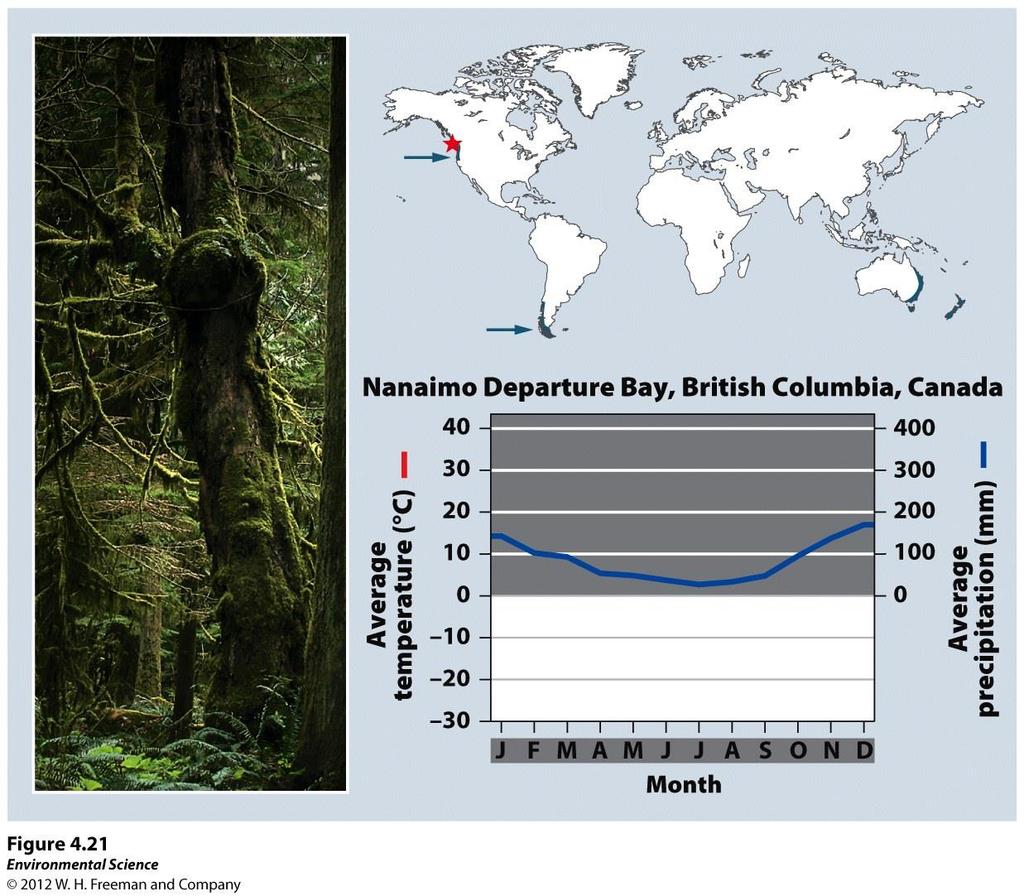
71 Rain Shadows When air moving inland from the ocean that contains a large amount of water vapor meets the windward side of a mountain range (the side facing the wind), it rises and begins to experience adiabatic cooling. Because water vapor condenses as air cools, clouds form and precipitation falls. The presence of the mountain range causes large amounts of precipitation to fall on its windward side. The cold, dry air then travels to the other side of the mountain range (the leeward side), where it descends and experiences higher pressures, which cause adiabatic heating. This air is now warm and dry and process arid conditions on the leeward side forming the region called a.
72 Rain Shadows When air moving inland from the ocean that contains a large amount of water vapor meets the windward side of a mountain range (the side facing the wind), it rises and begins to experience adiabatic cooling. Because water vapor condenses as air cools, clouds form and precipitation falls. The presence of the mountain range causes large amounts of precipitation to fall on its windward side. The cold, dry air then travels to the other side of the mountain range (the leeward side), where it descends and experiences higher pressures, which cause adiabatic heating. This air is now warm and dry and process arid conditions on the leeward side forming the region called a rain shadow.
73 Variations in Climate Determine the Dominant Plant Growth Forms of Terrestrial Biomes Climate affects the distribution of species around the globe. Organisms possess distinct growth forms due to adaptations to local temperature and precipitin patterns. Biomes- The presence of similar plant growth forms in areas possessing similar temperature and precipitation patterns.
74 Tundra Cold, treeless biome with low-growing vegetation. In winter, the soil is completely frozen. The tundra's growing season is very short, usually only about 4 months during summer. The underlying subsoil, known as permafrost is an impermeable, permanently frozen layer that prevents water from draining and roots from penetrating.
75 Tundra
76 Boreal Forest Forests made up primarily of coniferous (conebearing) evergreen trees that can tolerate cold winters and short growing seasons. Boreal forests are found between about 50 and 60 N in Europe, Russia and North America. This subarctic biome has a very cold climate, and plant growth is more constrained by temperature than precipitation. The soil is nutrient-poor due to slow decomposition.
77 Boreal Forest
78 Moderate temperatures Temperate and Rainforest high precipitation typify the temperate rainforest. The temperate rainforest is a coast biome and can be found along the west coast of North America from northern California to Alaska, in southern Chile, on the west coast of New Zealand, and on the island of Tasmania. The ocean currents help moderate temperature fluctuations and provide a source of water vapor. This biome has a nearly 12-month growing season where winters are rainy and summers are foggy. The mild temperatures and high precipitation supports the growth of very large trees.
79 Temperate Rainforest
80 Temperate Seasonal Forest Receive over 1 m (39 inches) of precipitation annually. Found in the eastern United States, Japan, China, Europe, Chile and eastern Australia. Dominated by broadleaf deciduous trees such as beech, male, oak and hickory. Warmer summer temperatures favor decomposition so soils generally contain more nutrients than those of boreal forests.

81 Temperate Seasonal Forest
82 Woodland/Shrubland Found on the coast of southern California, southern Australia, southern Africa and in the area surrounding the Mediterranean Sea. Hot, dry summers and mild, rainy winters are characteristic of this biome. There is a 12-month growing season, but plant growth is constrained by low precipitin in summer and by relatively low temperatures in winter. Wildfires are common and plants of this biome are well adapted to both fire and drought.
83 Woodland/Shrubland
84 Temperate Grassland/Cold Desert This biome has the lowest average annual precipitation of any temperate biome. These are found in the Great Plains of North America, in South America, and in central Asia and eastern Europe. Cold, harsh winters and hot, dry, summers characterize this biome. Plant growth is constrained by both insufficient precipitation in summer and cold temperatures in winter. Plants include grasses and non woody flowering plants that are well adapted to
85 Temperate Grassland/Cold Desert
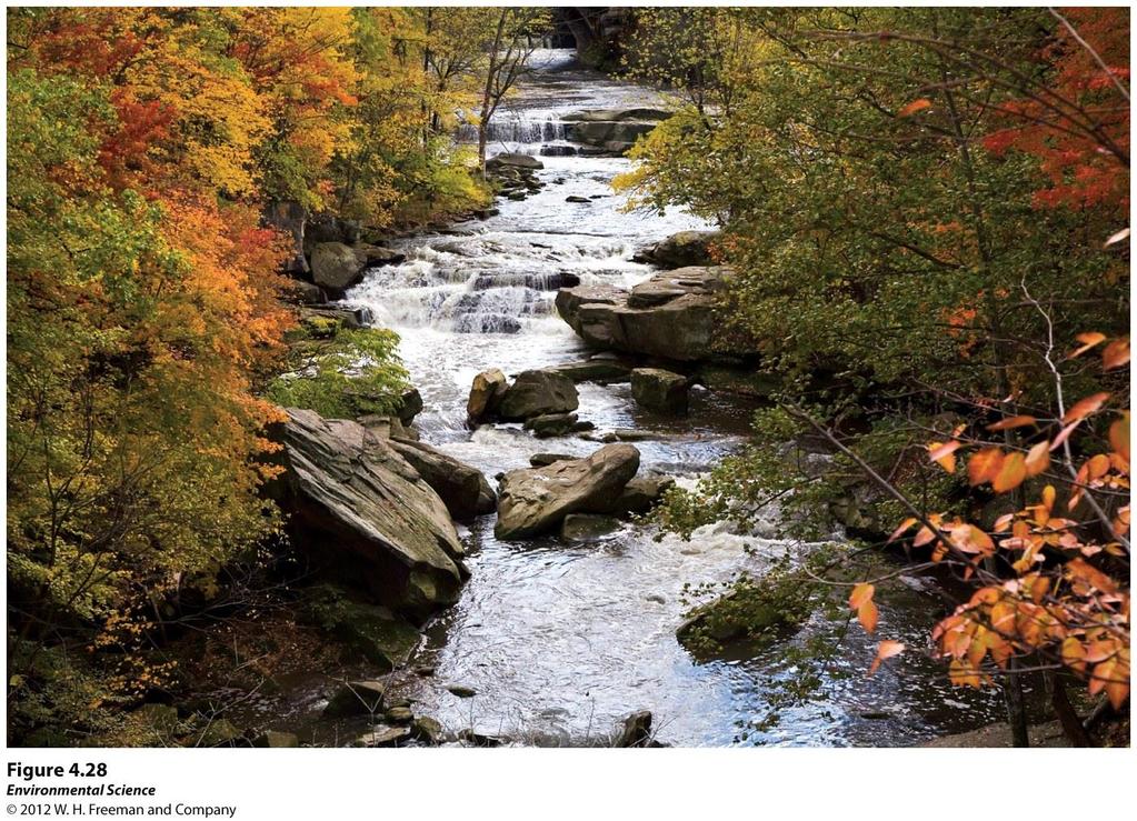
86 In the tropics, Tropical average Rainforest annual temperatures exceed 20 C. This biome is located approximately 20 N and S of the equator. They are found in Central and South America, Africa, Southeast Asia, and northeastern Australia. Precipitation occurs frequently and this biome is warm and wet with little temperature variation. Tropical rain forests have more biodiversity per hectare than any other terrestrial biome and contain up to two-thirds of Earth's
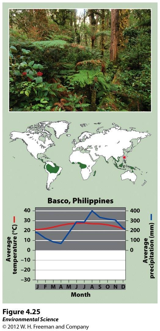
87 Tropical Rainforest
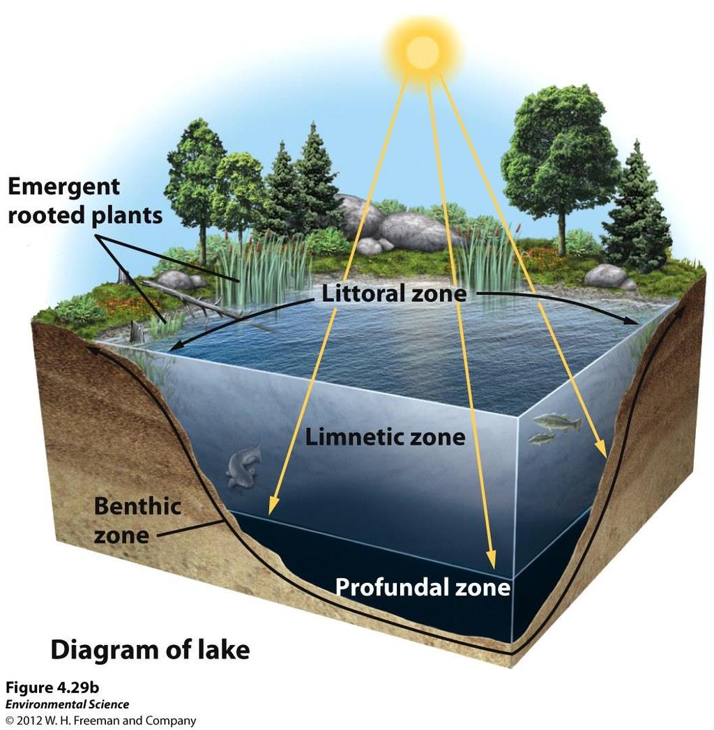
88 Tropical Warm temperatures Seasonal and Forest/Savanna distinct wet and dry seasons characterize this biome. Tropical seasonal forests are common in much of Central America, on the Atlantic coast of South America, in southern Asia, in northwestern Australia, and in sub-saharan Africa. Soil in this biome is fairly fertile and can be farmed due to high decomposition rates, but the low amount of precipitation constrains plants from using the soil nutrients that are released. Grasses and scattered deciduous trees are
89 Tropical Seasonal Forest/Savanna
90 Subtropical Desert This biome is found at 30 N and S with hot temperatures and extremely dry conditions. The Mojave Desert in the southwestern United States, the Sahara in Africa, the Arabian Desert of the Middle East and the GReat Victoria Desert of Australia are all subtropical deserts. Cacti, euphorbs and succulent plants are well adapted to this biome.
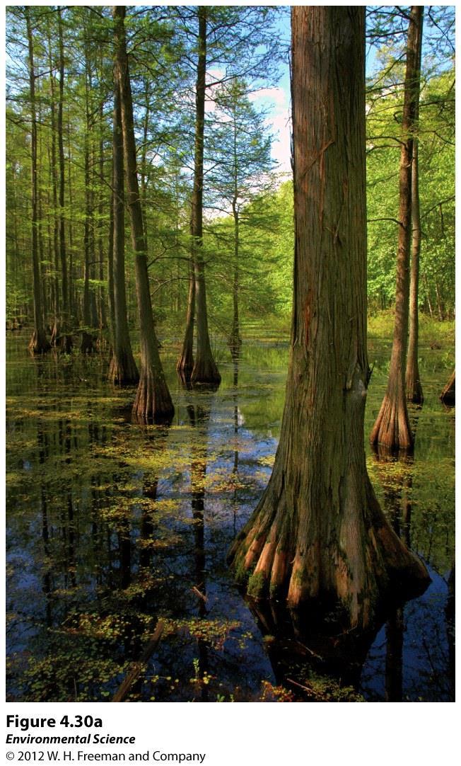
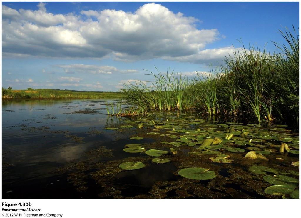
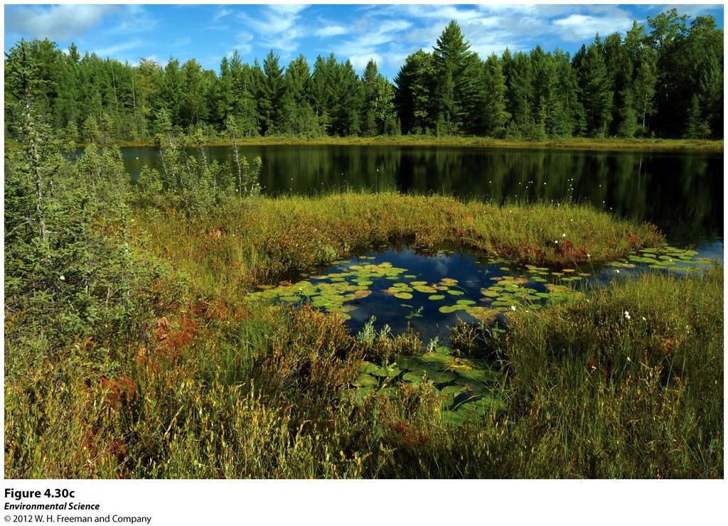
91 Subtropical Desert
92 Aquatic Biomes are Categorized by Salinity, Depth, and Water Flow
93 Streams and Rivers Flowing fresh water that may originate from underground springs or as runoff from rain or melting snow. Streams are typically narrow and carry relatively small amounts of water where rivers are usually wider and carry larger amounts of water.
94
95 Lakes and Ponds Standing water that some of which is too deep to support emergent vegetation. Lakes are larger than ponds but there is no clear point at which a pond is considered large enough to be called a lake.

96 Lakes and Ponds
97 Lakes and Ponds Littoral zone- the shallow area of soil and water near the shore where algae and emergent plants grow. Limnetic zone- open water, where rooted plants can no longer survive. Phytoplankton are the only photosynthetic organisms. This zone extends to as deep as sunlight can penetrate. Profundal zone- the zone where sunlight cannot penetrate and therefore producers cannot survive. Benthic zone- the muddy bottom of a lake or bond beneath the limnetic and profundal zone.
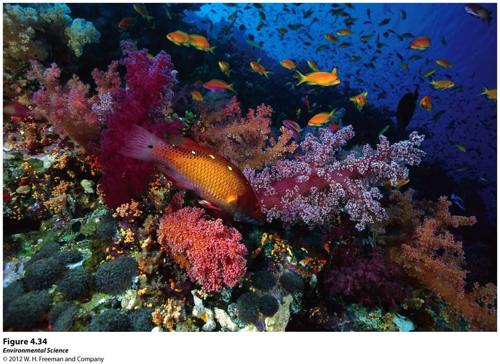
98 Freshwater Wetlands Aquatic biomes that are submerged or saturated by water for at least part of each year, but shallow enough to support emergent vegetation. These include swamps, marshes, and bogs.
99

100 Salt Marshes Found along the coast in temperate climates and contain non woody emergent vegetation. The salt marsh is one of the most productive biomes in the world.
101 Mangrove Swamps Found along tropical and subtropical coasts and contain trees whose roots are submerged in water. Mangrove trees are salt tolerant and help protect the coastlines from erosion and storm damage.

102 Figure 4.32
103 Intertidal Zone Narrow band of coastline that exists between the levels of high tide an low tide. Waves that crash onto the shore in this biome can make it a challenge for organisms to hold on and not get washed away.

104 Figure 4.33
105 Coral Reefs Found in warm, shallow waters beyond the shoreline. Earth's most diverse marine biome even though coral reefs are found in water that is relatively poor in nutrients and food. Coral bleaching- when the algae inside the coral dies. Scientists believe this is due to a combination of disease and environmental change.
106
107 The Open Ocean The depth that light can penetrate in the open ocean is dependent on the amount of sediment and algae suspended in the water. Photic zone- the zone that receives enough light to allow photosynthesis to occur. Aphotic zone- the deeper water that lacks sufficient light for photosynthesis. Chemosynthesis- The process that occurs in the aphotic zone when some species of bacteria use methane and hydrogen sulfide to generate energy.
Ocean Currents that Redistribute Heat Globally
 Ocean Currents that Redistribute Heat Globally Ocean Circulation Ocean Currents Fig. CO7 OCEAN CURRENTS Surface ocean currents are similar to wind patterns: 1. Driven by Coriolis forces 2. Driven by winds
Ecology. Professor Andrea Garrison Biology 3A Illustrations 2014 Cengage Learning unless otherwise noted
 Ecology Professor Andrea Garrison Biology 3A Illustrations 2014 Cengage Learning unless otherwise noted Ecology Ecology (oikos = house) is the study of where an organism lives and all the interactions
Atmosphere Circulation
 Atmosphere Circulation Winds What Causes Winds? Difference in air pressure due to unequal heating of the atmosphere. Temperatures vary according to the amount of sun it gets. Uneven heating of the Earth
OCEANOGRAPHY STUDY GUIDE
 OCEANOGRAPHY STUDY GUIDE Chapter 2 Section 1 1. Most abundant salt in ocean. Sodium chloride; NaCl 2. Amount of Earth covered by Water 71% 3. Four oceans: What are they? Atlantic, Pacific, Arctic, Indian
Meteorology I Pre test for the Second Examination
 Meteorology I Pre test for the Second Examination MULTIPLE CHOICE 1. A primary reason why land areas warm up more rapidly than water areas is that a) on land, all solar energy is absorbed in a shallow
Lornshill Academy. Geography Department Higher Revision Physical Environments - Atmosphere
 Lornshill Academy Geography Department Higher Revision Physical Environments - Atmosphere Physical Environments Atmosphere Global heat budget The earth s energy comes from solar radiation, this incoming
9/25/2014. Scales of Atmospheric Motion. Scales of Atmospheric Motion. Chapter 7: Circulation of the Atmosphere
 Chapter 7: Circulation of the Atmosphere The Atmosphere: An Introduction to Meteorology, 12 th Lutgens Tarbuck Lectures by: Heather Gallacher, Cleveland State University Scales of Atmospheric Motion Small-
Introduction to Oceanography OCE 1001
 Introduction to Oceanography OCE 1001 Lecture Notes Chantale Bégin & Jessica Fry Version 2.1 10. Ocean Circulation (Trujillo, Chapter 7) Major ocean currents are stable and predictable; they have been
Ocean Current Worksheet
 Ocean Current Worksheet Temperature Affects and Surface Currents: Surface waters of the Earth s oceans are forced to move, primarily by winds. Where winds blow in the same direction for a long period of
The Movement of Ocean Water. Currents
 The Movement of Ocean Water Currents Ocean Current movement of ocean water that follows a regular pattern influenced by: weather Earth s rotation position of continents Surface current horizontal movement
7-1 What Factors Influence Climate?
 Key Questions and Concepts 7-1 What factors influence climate? CONCEPT 7-1 An area s climate is determined mostly by solar radiation, the earth s rotation, global patterns of air and water movement, gases
Chapter 6: Atmospheric Pressure, Wind, and Global Circulation
 Discovering Physical Geography Third Edition by Alan Arbogast Chapter 6: Atmospheric Pressure, Wind, and Global Circulation Factors That Influence Air Pressure Air Pressure is the measured weight of air
Lesson: Ocean Circulation
 Lesson: Ocean Circulation By Keith Meldahl Corresponding to Chapter 9: Ocean Circulation As this figure shows, there is a connection between the prevailing easterly and westerly winds (discussed in Chapter
Winds and Ocean Circulations
 Winds and Ocean Circulations AT 351 Lab 5 February 20, 2008 Sea Surface Temperatures 1 Temperature Structure of the Ocean Ocean Currents 2 What causes ocean circulation? The direction of most ocean currents
Prevailing Winds. The Coriolis Effect
 Prevailing Winds 1. Wind: a movement of air in the atmosphere. Bill Nye wind (2 minutes) 2. Local or regional wind: occur in fairly small areas. 3. Prevailing winds: Major wind pattern that affect large
W3 Global Circulation Systems
 W3 Global Circulation Systems Which regions of Earth receive the most energy from the Sun? If not for global circulation systems There would only be two narrow regions that would support life What
CHAPTER 6 Air-Sea Interaction
 CHAPTER 6 Air-Sea Interaction What causes Earth s seasons? Tilt (23.5 ) responsible for seasons 2011 Pearson Education, Inc. Distribution of Solar Energy Distribution of Solar Energy Atmosphere absorbs
Assessment Schedule 2016 Earth and Space Science: Demonstrate understanding of processes in the ocean system (91413)
") NCEA Level 3 Earth & Space Science (91413) 2016 page 1 of 6 Assessment Schedule 2016 Earth and Space Science: Demonstrate processes in the ocean system (91413) Evidence Statement Q Evidence with with Excellence
NCEA Level 3 Earth & Space Science (91413) 2016 page 1 of 6 Assessment Schedule 2016 Earth and Space Science: Demonstrate processes in the ocean system (91413) Evidence Statement Q Evidence with with Excellence
Applied Earth Science Climate Exam Practice Questions Page 1
 Name: 1. Which combination of climate factors generally results in the coldest temperatures? A) low elevation and low latitude B) low elevation and high latitude C) high elevation and low latitude D) high
Duckies have been found in Hawaii, Alaska, S. America, Scotland, Washington state and Australia as of 2012.
 Duckies have been found in Hawaii, Alaska, S. America, Scotland, Washington state and Australia as of 2012. We learned that it takes 3 years to complete one circuit of the North Pacific Gyre flow in the
Atmosphere & Weather. Earth Science
 Atmosphere & Weather Earth Science Energy Transfer in the Atmosphere Earth s energy is provided by the SUN! Energy is important to us because it 1. Drives winds and ocean currents. 2. Allows plants to
Fluid Circulation (Student Mastery Objectives) -The most frequent type of heat transfer of energy in the atmosphere is convection.
 -The most frequent type of heat transfer of energy in the atmosphere is convection.") Fluid Circulation (Student Mastery Objectives) -The most frequent type of heat transfer of energy in the atmosphere is convection. -Differences in density affect the circulation of fluids. Cold air is
Fluid Circulation (Student Mastery Objectives) -The most frequent type of heat transfer of energy in the atmosphere is convection. -Differences in density affect the circulation of fluids. Cold air is
Greenhouse Effect Activity
 Greenhouse Effect Activity Objectives: The student will: 1. Read and use weather instruments. 2. Collect and record temperature readings. 3. Describe the concept of the greenhouse effect. Materials: Fish
CHAPTER 7 Ocean Circulation
 1 2 3 4 5 6 7 8 9 10 11 12 13 14 CHAPTER 7 Ocean Circulation Words Ocean currents Moving seawater Surface ocean currents Transfer heat from warmer to cooler areas Similar to pattern of major wind belts
Name Date L.O: SWBAT explain what breezes, planetary winds, ocean currents & monsoons are.
 Name Date L.O: SWBAT explain what breezes, planetary winds, ocean currents & monsoons are. 1. A cool breeze is blowing toward the land from the ocean on a warm, cloudless summer day. This condition is
Agronomy 406 World Climates
 Agronomy 406 World Climates January 30, 2018 Monsoons. Ocean properties and circulation. Review for today: Online textbook: 1.3.1 (Sea water) Composition and properties. For Thursday: Rahmstorf, S.: The
Jeopardy Q $100 Q $100 Q $100 Q $100 Q $100 Q $200 Q $200 Q $200 Q $200 Q $200 Q $300 Q $300 Q $300 Q $300 Q $300 Q $400 Q $400 Q $400 Q $400 Q $400
 Jeopardy Grab Bag Review Grab Bag Review 2 Biomes Climate Factors that affect climate Q $100 Q $200 Q $300 Q $400 Q $500 Q $100 Q $100 Q $100 Q $100 Q $200 Q $200 Q $200 Q $200 Q $300 Q $300 Q $300 Q $300
Lecture 13 El Niño/La Niña Ocean-Atmosphere Interaction. Idealized 3-Cell Model of Wind Patterns on a Rotating Earth. Previous Lecture!
 Lecture 13 El Niño/La Niña Ocean-Atmosphere Interaction Previous Lecture! Global Winds General Circulation of winds at the surface and aloft Polar Jet Stream Subtropical Jet Stream Monsoons 1 2 Radiation
Friday, February 8 th. Winds/Coriolis Worksheet: Due Today Lab Worksheet: Finish Questions
 Ocean Currents Friday, February 8 th Winds/Coriolis Worksheet: Due Today Lab Worksheet: Finish Questions Non-rotating Earth Convection cell model Add rotation and add landmasses unequal heating and cooling
3/22/11. General Circulation of the Atmosphere. General Circulation of the Atmosphere
 Chapter 10 General refers to the average air flow, actual winds will vary considerably. Average conditions help identify driving forces. The basic cause of the general circulation is unequal heating of
Wednesday, September 27, 2017 Test Monday, about half-way through grading. No D2L Assessment this week, watch for one next week
 Wednesday, September 27, 2017 Test Monday, about half-way through grading No D2L Assessment this week, watch for one next week Homework 3 Climate Variability (due Monday, October 9) Quick comment on Coriolis
APES CHAPTER 4 NOTES (MRS. BAUCK): GLOBAL CLIMATES AND BIOMES
: GLOBAL CLIMATES AND BIOMES") APES CHAPTER 4 NOTES (MRS. BAUCK): GLOBAL CLIMATES AND BIOMES MODULE 9: The Unequal Heating of Earth I. Atmospheric Layers (FYI: 1.61 km = 1 mi) Source: Royal BC Museum A. troposphere 1) lowest layer:
APES CHAPTER 4 NOTES (MRS. BAUCK): GLOBAL CLIMATES AND BIOMES MODULE 9: The Unequal Heating of Earth I. Atmospheric Layers (FYI: 1.61 km = 1 mi) Source: Royal BC Museum A. troposphere 1) lowest layer:
Atmospheric & Ocean Circulation-
 Atmospheric & Ocean Circulation- Overview: Atmosphere & Climate Atmospheric layers Heating at different latitudes Atmospheric convection cells (Hadley, Ferrel, Polar) Coriolis Force Generation of winds
Atmospheric Circulation
 Atmospheric Circulation Why do we say Earth's temperature is moderate? It may not look like it, but various processes work to moderate Earth's temperature across the latitudes. Atmospheric circulation
Horizontal movement of air between cooler and warmer regions. - horizontal movement of air Convection over areas where is
 Winds and Water Chapter 9 continued... Uneven Heating The various materials of the earth absorb and emit energy at different rates Convection Heated air expands; density reduced; air rises Upward movement
El Niño Lecture Notes
 El Niño Lecture Notes There is a huge link between the atmosphere & ocean. The oceans influence the atmosphere to affect climate, but the atmosphere also influences the ocean, which can also affect climate.
OCN 201 Surface Circulation
 OCN 201 Surface Circulation Excess heat in equatorial regions requires redistribution toward the poles 1 In the Northern hemisphere, Coriolis force deflects movement to the right In the Southern hemisphere,
WINDS Understand the cause of wind and how it affects climate Chapter 4 Pages 59-67
 WINDS Understand the cause of wind and how it affects climate Chapter 4 Pages 59-67 What is Wind? A wind is a horizontal movement of air across a surface. Vertical movements are currents or updrafts and
The atmospheric circulation system
 The atmospheric circulation system Key questions Why does the air move? Are the movements of the winds random across the surface of the Earth, or do they follow regular patterns? What implications do these
Full Name: Class: Period: Date:
 Topic/Objective: Essential Question: Full Name: Class: Period: Date: Tutor Use Only: Air Pressure and Wind (Chapter 19) Air Pressure the weight of the atmosphere pushing down on the Earth exerting a force
Water on Earth. How do oceans relate to weather and the atmosphere? Solar Radiation and Convection Currents
 Earth is often called the Blue Planet because so much of its surface (about 71%) is covered by water. Of all the water on Earth, about 96.5% is held in the world s oceans. As you can imagine, these oceans
SIO20 - Midterm Examination 2 v1 Winter Section A. Circle the letter corresponding to the best answer. (1 point each)
") NAME: Section A. Circle the letter corresponding to the best answer. (1 point each) 1. Rainbows result from: a. refraction and reflection of sunlight by water droplets b. reflection of sunlight by oceans
NAME: Section A. Circle the letter corresponding to the best answer. (1 point each) 1. Rainbows result from: a. refraction and reflection of sunlight by water droplets b. reflection of sunlight by oceans
3 Global Winds and Local Winds
 CHAPTER 1 3 Global Winds and Local Winds SECTION The Atmosphere BEFORE YOU READ After you read this section, you should be able to answer these questions: What causes wind? What is the Coriolis effect?
Water Budget I: Precipitation Inputs
 Water Budget I: Precipitation Inputs Forest Cover Global Mean Annual Precipitation (MAP) Biomes and Rainfall Forests won t grow where P < 15 / yr Forest type depends strongly on rainfall quantity, type
GEOGRAPHY UNIT 2 REVIEW. 1. The daily atmospheric conditions, such as heat, moisture and air movement for a particular area are known as
 UNIT 2 REVIEW GEOGRAPHY Name: 1. The daily atmospheric conditions, such as heat, moisture and air movement for a particular area are known as 2. The average conditions of the weather for a long period
Trade winds Prevailing westerlies east
 Warm-up Page: 528, 1. What is the major wind belt that is nearest the equator? Trade winds Page: 528, 2. What is the major wind belt that the most of the USA belongs to: Prevailing westerlies Page: 528,
Write answers on your own paper. A. the Sun B. the Moon C. Earth s gravity D. Earth s rotation
 The tmosphere Write answers on your own paper 1. What is the primary energy source that drives all weather events, including precipitation, hurricanes, and tornados?. the Sun. the Moon C. Earth s gravity
Section 6. The Surface Circulation of the Ocean. What Do You See? Think About It. Investigate. Learning Outcomes
 Chapter 5 Winds, Oceans, Weather, and Climate Section 6 The Surface Circulation of the Ocean What Do You See? Learning Outcomes In this section, you will Understand the general paths of surface ocean currents.
Chapter 22, Section 1 - Ocean Currents. Section Objectives
 Chapter 22, Section 1 - Ocean Currents Section Objectives Intro Surface Currents Factors Affecting Ocean Currents Global Wind Belts (you should draw and label a diagram of the global wind belts) The Coriolis
Notepack 41. Aim: What factors determine the climate of a certain area? Do Now: What is the difference between weather and climate?
 Notepack 41 Aim: What factors determine the climate of a certain area? Do Now: What is the difference between weather and climate? WEATHER VS. CLIMATE Weather atmospheric conditions at a certain location
Name: Class: Date: Multiple Choice Identify the choice that best completes the statement or answers the question.
 Name: Class: _ Date: _ Ch. 9 Climate Test Multiple Choice Identify the choice that best completes the statement or answers the question. 1. The average, year-after-year conditions of temperature, precipitation,
The General Circulation and El Niño. Dr. Christopher M. Godfrey University of North Carolina at Asheville
 The General Circulation and El Niño Dr. Christopher M. Godfrey University of North Carolina at Asheville Global Circulation Model Air flow broken up into 3 cells Easterlies in the tropics (trade winds)
Review for the second quarter. Mechanisms for cloud formation
 Review for the second quarter Mechanisms for cloud formation 1 Rising air expands and cools; Sinking air compresses and warms. (18) (24) Dry adiabatic lapse rate (10 o C/km): the rate of temperature decrease
Current: large mass of continuously moving ocean water
 Ocean Currents Current: large mass of continuously moving ocean water Surface Currents--Wind Circulation These waters make up about 10% of all the water in the ocean. These waters are the upper 400 meters
Lecture 13 March 24, 2010, Wednesday. Atmospheric Pressure & Wind: Part 4
 Lecture 13 March 24, 2010, Wednesday Atmospheric Pressure & Wind: Part 4 Synoptic scale winds Mesoscale winds Microscale winds Air-sea interactions The largest synoptic scale wind. Monsoon: Arabic for
EARTH, PLANETARY, & SPACE SCIENCES 15 INTRODUCTION TO OCEANOGRAPHY. LABORATORY SESSION #6 Fall Ocean Circulation
 EARTH, PLANETARY, & SPACE SCIENCES 15 INTRODUCTION TO OCEANOGRAPHY LABORATORY SESSION #6 Fall 2017 Ocean Circulation The focus of the Lab this week is circulation of the ocean and atmosphere. Here, you
CHAPTER 11.1 THE WORLD OCEAN MARINE BIOMES NOTES
 CHAPTER 11.1 THE WORLD OCEAN MARINE BIOMES NOTES 1. The world ocean can be divided into zones both and. The,, and zones that apply to large lakes also apply to the ocean. 2. In addition to the depth zones,
Canada s Natural Systems. Canadian Geography 1202
 Canada s Natural Systems Canadian Geography 1202 Canada s Natural Systems Natural System: A system found in nature Here are the four natural systems that we will explore in the next few weeks 1. Canada
Section 1. Global Wind Patterns and Weather. What Do You See? Think About It. Investigate. Learning Outcomes
 Chapter 5 Winds, Oceans, Weather, and Climate Section 1 Global Wind Patterns and Weather What Do You See? Learning Outcomes In this section, you will Determine the effects of Earth s rotation and the uneven
Air Pressure and Wind
 Air Pressure and Wind 19.1 Understanding Air Pressure Air Pressure Defined Air pressure is the pressure exerted by the weight of air. Air pressure is exerted in all directions down, up, and sideways. The
Chapter 9: Circulation of the Ocean
 Chapter 9: Circulation of the Ocean Tropical gardens on Britain s Scilly Isles. Only 48 kilometers (30 miles) off the coast of Cornwall at 50 N, these scenic islands lie in the path of the warm waters
Meteorology. Circle the letter that corresponds to the correct answer
 Chapter 7 Worksheet 2 Meteorology Name: Circle the letter that corresponds to the correct answer 1) Which of the following factors contributes to the general subsidence in the latitude zone 20 degrees
ATMOSPHERIC CIRCULATION. WIND = The horizontal movement of air. Results from the differences in air pressure. Always moves from HIGH to LOW.
 ATMOSPHERIC CIRCULATION WIND = The horizontal movement of air. Results from the differences in air pressure. Always moves from HIGH to LOW. Pressure differences result from variations in temperature. AIR
Exit Ticket: Coriolis Effect
 Exit Ticket: Coriolis Effect 1. How does the Coriolis Effect influence the path of projectiles or wind traveling through the atmosphere? Causes them to curve 2. In which direction does the Coriolis Effect
Chapter. Air Pressure and Wind
 Chapter Air Pressure and Wind 19.1 Understanding Air Pressure Air Pressure Defined Air pressure is the pressure exerted by the weight of air. 19.1 Understanding Air Pressure Air Pressure Defined Air pressure
HYDROSPHERE, OCEANS AND TIDES
 HYDROSPHERE, OCEANS AND TIDES Revision 10x10learning.com 1 Chapter 12. In the Earth s Atmosphere On surface of the Earth Under the ground Hydrosphere comprises of ALL WATER Water Vapour = 0.001% Is very
Chapter 7 Weather and Climate
 Chapter 7 Weather and Climate *Describe what weather is, what affects it, and where it occurs. *Explain the connection between air pressure and wind. * *Many factors affect a region s weather. * *atmosphere
McKnight's Physical Geography 11e
 Chapter 2 Lecture McKnight's Physical Geography 11e Lectures Chapter 5 Atmospheric Pressure and Wind Michael Commons Ohio Northern University Atmospheric Pressure and Wind The Nature of Atmospheric Pressure
Atmospheric Circulation. Recall Vertical Circulation
 Today s topics: Atmospheric circulation: generation of wind patterns on a rotating Earth Seasonal patterns of climate: Monsoons and Sea Breezes Tropical Cyclones: Hurricanes and typhoons Atmospheric Circulation
ESCI 107 The Atmosphere Lesson 11 Global Circulation
 Reading: Meteorology Today, Chapter 10 THE GLOBAL CIRCULATION ESCI 107 The Atmosphere Lesson 11 Global Circulation Latitudinal heat imbalance The tropics receive more radiation than they emit. The polar
Atmospheric Circulation (Ch. 8) Ocean & Atmosphere are intertwined Gases & waters freely exchanged Wind Weather Climate
 Ocean & Atmosphere are intertwined Gases & waters freely exchanged Wind Weather Climate") Atmospheric Circulation (Ch. 8) Ocean & Atmosphere are intertwined Gases & waters freely exchanged Wind Weather Climate Atmospheric Structure Consists of Layers Separated by Temperature Stratosphere: Temperature
Atmospheric Circulation (Ch. 8) Ocean & Atmosphere are intertwined Gases & waters freely exchanged Wind Weather Climate Atmospheric Structure Consists of Layers Separated by Temperature Stratosphere: Temperature
Introduction to Physical Oceanography STUDENT NOTES Date: 1. What do you know about solar radiation at different parts of the world?
 Introduction to Physical Oceanography STUDENT NOTES Date: 1 Warm up What do you know about solar radiation at different parts of the world? What affect does the tilt of the Earth have on the northern and
Section 3: Atmospheric Circulation
 Section 3: Atmospheric Circulation Preview Key Ideas The Coriolis Effect Global Winds Local Winds Maps in Action Key Ideas Explain the Coriolis effect. Describe the global patterns of air circulation,
Factors Affecting Wind
 Understanding Air Pressure Average air pressure at sea level is about 1 kg per cm 2 (14.7 lbs/in 2 ) Roughly the same pressure that is produced by a column of water 10 m (33 ft) high The pressurized suits
Currents & Gyres Notes
 Currents & Gyres Notes Current A river of water flowing in the ocean. 2 Types of Currents Surface Currents wind-driven currents that occur in the top 100m or less Deep Currents density-driven currents
9. The Earth's planetary winds are deflected as a result of the Earth's A) revolution around the Sun B) seasonal changes C) rotation on its axis D)
 revolution around the Sun B) seasonal changes C) rotation on its axis D)") 1. Which ocean current transports warm water away from Earth s equatorial region? A) Brazil Current B) Guinea Current C) Falkland Current D) California Current 2. The Gulf Stream and North Atlantic Current
1. Which ocean current transports warm water away from Earth s equatorial region? A) Brazil Current B) Guinea Current C) Falkland Current D) California Current 2. The Gulf Stream and North Atlantic Current
Higher Atmosphere. Earth s Heat Budget. Global Insolation. Global Transfer Of Energy. Global Temperatures. Inter Tropical Convergence Zone
 Higher Atmosphere Earth s Heat Budget Global Insolation Global Transfer Of Energy Global Temperatures Inter Tropical Convergence Zone Climate Graph Earth s Heat Budget Task 1 Use the Power Point to help
Weather Unit Study Guide
 Weather Unit Study Guide - 2018 Weather vs Climate What does weather measure? The condition of the earth's atmosphere at a particular time and place. How are climate and weather different? Climate is the
Weather & Atmosphere Study Guide
 Weather & Atmosphere Study Guide 1. Draw a simple water cycle diagram using the following words: Precipitation, Evaporation, Condensation, Transpiration 2. In your own words, explain the difference between
For Class Today How does ocean water circulate? Ocean currents, surface currents, gyres, currents & climate, upwelling, deep ocean circulation
 For Class Today Modified Cornell Notes on section 16.1 (pg. 448-453) **Follow the guide in your ISN and previous notes for help** Heading: How does ocean water circulate? Left hand side categories: Ocean
Name Class Date. Use the terms from the following list to complete the sentences below. Each term may be used only once. Some terms may not be used.
 Assessment Chapter Test B The Movement of Ocean Water USING KEY TERMS Use the terms from the following list to complete the sentences below. Each term may be used only once. Some terms may not be used.
Lesson: Atmospheric Dynamics
 Lesson: Atmospheric Dynamics By Keith Meldahl Corresponding to Chapter 8: Atmospheric Circulation Our atmosphere moves (circulates) because of uneven solar heating of the earth s surface, combined with
Chapter 7: Circulation And The Atmosphere
 Chapter 7: Circulation And The Atmosphere Highly integrated wind system Main Circulation Currents: series of deep rivers of air encircling the planet Various perturbations or vortices (hurricanes, tornados,
1 Currents. TAKE A LOOK 2. Read a Map In what direction does the Gulf Stream flow?
 CHAPTER 5 1 Currents SECTION The Movement of Ocean Water BEFORE YOU READ After you read this section, you should be able to answer these questions: What factors affect ocean currents? Why are ocean currents
Influences on Weather and Climate Weather and Climate. Coriolis Effect
 Influences on Weather and limate Weather and limate oriolis Effect 1 limate is defined as the common weather conditions in one area over a long period of time. Temperature, humidity, rainfall, and wind
Water Budget I: Precipitation Inputs
 Water Budget I: Precipitation Inputs Forest Cover Forests and Rainfall Forests won t grow where P < 15 / yr Forest type depends strongly on rainfall quantity, type (snow, rain) and timing (summer, winter)
Wind is caused by differences in air pressure created by changes in temperature and water vapor content.
 Topic 8: Weather Notes, Continued Workbook Chapter 8 Wind is caused by differences in air pressure created by changes in temperature and water vapor content. Wind blows from high pressure areas to low
Natural Regions of the World
 Natural Regions of the World Revision for Competitive Exams 10x10learning.com 1 Concept of Natural Regions provides a framework for understanding the diversity of physical and biological environment Taiga
Name: OBJECTIVES: By the end of today s lesson, you will be able to
 7 th Grade Science Unit: Water s Cycles and Patterns Lesson: WCP 21 Name: Date: Monday, October 3, 2016 Homeroom: _ OBJECTIVES: By the end of today s lesson, you will be able to SWBAT Explain how currents
Directed Reading. Section: Ocean Currents. a(n). FACTORS THAT AFFECT SURFACE CURRENTS
. FACTORS THAT AFFECT SURFACE CURRENTS") Skills Worksheet Directed Reading Section: Ocean Currents 1. A horizontal movement of water in a well-defined pattern is called a(n). 2. What are two ways that oceanographers identify ocean currents? 3.
Skills Worksheet Directed Reading Section: Ocean Currents 1. A horizontal movement of water in a well-defined pattern is called a(n). 2. What are two ways that oceanographers identify ocean currents? 3.
Unit 2 World Climate Patterns
 Unit 2 World Climate Patterns Weather the day to day or short term conditions of the atmosphere. Weather includes variables such as temperature, precipitation, humidity, cloud cover, wind, and air pressure.
Sailing the Seas: Wind Driven Ocean Circulation Ocean Gyres
 Sailing the Seas: Wind Driven Ocean Circulation Ocean Gyres Ocean Currents What Happens at the Coast? Readings: Ch 9: 9.2-9.6, 9.8-9.13 Graphic: America's Cup sailboat race off Newport, Rhode Island. J.
Wind and Air Pressure
 Wind and Air Pressure When air moves above the surface of the Earth, it is called wind. Wind is caused by differences in air pressure. When a difference in pressure exists, the air will move from areas
Atmospheric Circulation. Density of Air. Density of Air: H 2 O and Pressure effects
 Today s topics: Atmospheric circulation: generation of wind patterns on a rotating Earth Seasonal patterns of climate: Monsoons and Sea Breezes Tropical Cyclones: Hurricanes and typhoons Atmospheric Circulation
Deserts and Desert Environments
 Deserts and Desert Environments Introduction Aeolian geomorphology is the study of the effect of wind on Earth surface processes and landforms Wind: the movement of air from one place to another, specifically
Lecture Outlines PowerPoint. Chapter 18 Earth Science 11e Tarbuck/Lutgens
 Lecture Outlines PowerPoint Chapter 18 Earth Science 11e Tarbuck/Lutgens 2006 Pearson Prentice Hall This work is protected by United States copyright laws and is provided solely for the use of instructors
Marine Ecosystems. Aquatic Ecosystems Section 2
 Marine Ecosystems Marine ecosystems are located mainly in coastal areas and in the open ocean. Organisms that live in coastal areas adapt to changes in water level and salinity. Organisms that live in
Lecture 5.1 Surface Ocean Circulation. Image from Daily Mail Newspaper, UK
 Lecture 5.1 Surface Ocean Circulation Image from Daily Mail Newspaper, UK Announcements Midterm is Thursday, consists of 25 multiple choice, 3 pages short answer questions No Scantron needed Calculators,
Global Winds AOSC 200 Tim Canty
 Global Winds AOSC 200 Tim Canty Class Web Site: http://www.atmos.umd.edu/~tcanty/aosc200 Topics for today: Global Wind Patterns Deserts Jet Stream Monsoons Ocean transport Ocean cycles Lecture 16 Oct 24
Nevis Hulme Gairloch High School John Smith Invergordon Academy. Gairloch High School / Invergordon Academy
 Nevis Hulme Gairloch High School John Smith Invergordon Academy 1 Gairloch High School / Invergordon Academy ATMOSPHERIC CIRCULATION The Three Cell Model Global Winds The ITCZ The purpose of this presentation