LES CAHIERS D APPRENTISSAGE MARITIME AIDS TO NAVIGATION AIDS TO NAVIGATION IALA MARITIME BUOYAGE SYSTEM. Page 1 sur 22
|
|
|
- Theodora Wade
- 6 years ago
- Views:
Transcription


1 IALA MARITIME BUOYAGE SYSTEM LES CAHIERS D APPRENTISSAGE MARITIME Page 1 sur 22
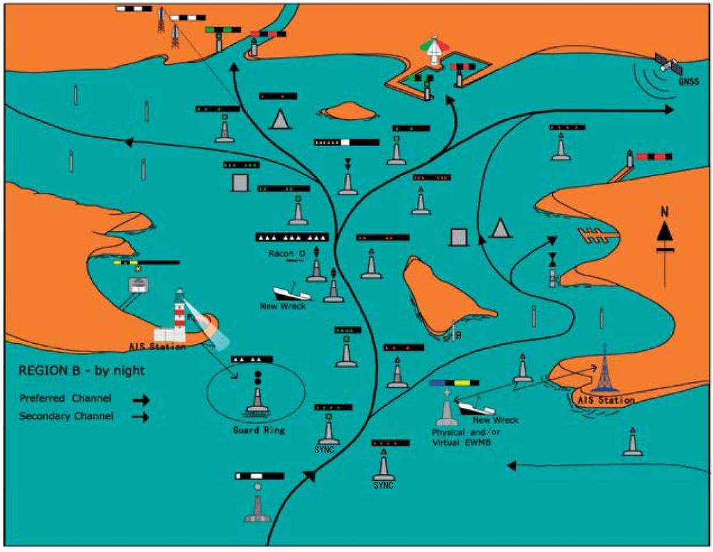
2 GENERAL PRINCIPLES OF THE SYSTEM The responsibility for safe navigation resides with the mariner, through the appropriate use of aids to navigation in conjunction with official nautical documents and prudent seamanship, including voyage planning as defined in IMO Resolutions. The IALA Aids to Navigation system has two components: The Maritime Buoyage System and other aids to navigation comprised of fixed and floating devices. This is primarily a physical system, however all of the marks may be complemented by electronic means. Within the IALA Buoyage System there are 6 types of marks that may be used in combination. The mariner can easily distinguish between these marks by readily identifiable characteristics. The Maritime Buoyage System provides rules that apply to all fixed and floating marks (other than lighthouses, sector lights, leading lights and marks, lightships and large navigational buoys) serving to indicate: - The lateral limits of navigable channels. - Natural dangers and other obstructions such as wrecks. - Landfall, course to steer, and other areas or features of importance to the mariner. - New dangers. The Maritime Buoyage System provides six types of marks that may be used in combination: 1. Lateral marks, used in conjunction with a conventional direction of buoyage, generally used for well defined channels. These marks indicate the port and starboard sides of the route to be followed. Where a channel divides, a modified lateral mark may be used to indicate the preferred route. Lateral marks differ between Buoyage Regions A and B. 2. Cardinal marks, used in conjunction with the mariner's compass, to indicate where the mariner may find navigable water. 3. Isolated Danger marks to indicate isolated dangers of limited size that have navigable water all around them. 4. Safe Water marks to indicate that there is navigable water all around their position, e.g. mid-channel marks. 5. Special marks, not primarily intended to assist navigation but to indicate an area or feature referred to in nautical documents. 6. Emergency Wreck Marking Buoy for the marking of new, dangerous wrecks. The significance of the mark depends upon one or more of the following features: By night, colour and rhythm of light and/or illumination enhancement. By day, colour, shape, top-mark, and/or light (including colour and rhythm). By electronic (digital) symbology, e.g. as a complement to physical marks. By electronic (digital) symbology solely. 1. LATERAL MARKS Following the sense of a conventional direction of buoyage, Lateral marks in Region A utilize red and green colours by day and night to denote the port and starboard sides of channels respectively. However, in Region B these colours are reversed with red to starboard and green to port. A modified Lateral mark may be used at the point where a channel divides to distinguish the preferred channel, that is to say the primary channel. Page 2 sur 22
3 Definition of conventional direction of buoyage The conventional direction of buoyage, which must be indicated in appropriate nautical documents, may be either: The general direction taken by the mariner when approaching a harbour, river, estuary or other waterway from seaward, or The direction determined by the proper authority in consultation, where appropriate, with neighbouring countries. In principle it should follow a clockwise direction around land masses. Numbering or lettering If marks at the sides of a channel are numbered or lettered, the numbering or lettering shall follow the conventional direction of buoyage. 2. CARDINAL MARKS Cardinal marks indicate that the deepest water in the area lies to the named side of the mark. This convention is necessary even though for example, a North mark may have navigable water not only to the North but also East and West of it. The mariner will know he is safe to the North, but must consult his chart for further guidance. Cardinal marks do not have a distinctive shape but are normally pillar or spar. They are always painted in yellow and black horizontal bands and their distinctive double cone topmarks are always black. An aide-memoire to their colouring is provided by regarding the topmarks as pointers to the positions of the black band(s): North: Topmarks pointing upward & black band above yellow band South: Topmarks pointing downward & black band below yellow band East: Topmarks pointing away from each other & black bands above and below a yellow band West: Topmarks pointing towards each other & yellow bands above and below a black band. Cardinal marks also have a special system of flashing white lights. The rhythms are basically all very quick (VQ) or quick (Q) flashing but broken into varying lengths of the flashing phase. very quick flashing is defined as a light flashing at a rate of either 120 or 100 flashes per minute, quick flashing is a light flashing at either 60 or 50 flashes per minute. The characters used for Cardinal marks will be seen to be as follows: North: Continuous very quick flashing or quick flashing; East: Three very quick or quick flashes followed by darkness; South: Six very quick or quick flashes followed immediately by a long flash, then darkness; West: Nine very quick or quick flashes followed by darkness. The concept of three, six, nine is easily remembered when one associates it with a clock face. The long flash, defined as a light appearance of not less than 2 seconds, is merely a device to ensure that three or nine very quick or quick flashes cannot be mistaken for six. It will be observed that two other marks use white lights: Isolated Danger marks and Safe Water marks. Each has a distinctive light rhythm that cannot be confused with the very quick or quick flashing light of the Cardinal marks. Page 3 sur 22
4 Definition of Cardinal quadrants and marks The four quadrants (North, East, South and West) are bounded by the true bearings NW- NE, NE-SE, SE-SW, SW-NW, taken from the point of interest. A Cardinal mark is named after the quadrant in which it is placed. The name of a Cardinal mark indicates that it should be passed to the named side of the mark. Use of Cardinal Marks A Cardinal mark may be used, for example: - To indicate that the deepest water in that area is on the named side of the mark. - To indicate the safe side on which to pass a danger. - To draw attention to a feature in a channel such as a bend, a junction, a bifurcation or the end of a shoal. 3. ISOLATED DANGER MARK The Isolated Danger mark is a mark erected on, or moored on, an isolated danger of small area that has navigable water all around it. Because the extent of the danger and the safe passing distance cannot be specified for all circumstances in which this mark may be used, the mariner shall consult the chart and nautical publications for guidance. Isolated Danger Marks are black with one or more broad horizontal red bands. Distinctive double black spherical topmarks and Group flashing (2) white lights, serve to distinguish Isolated Danger marks from Cardinal marks. 4. SAFE WATER MARKS The Safe Water mark has navigable water all around it, but does not mark a danger. Safe Water marks can be used, for example, as fairway, as centre line marks and midchannel marks. Such a mark may also be used to indicate a landfall. Safe Water marks have an appearance quite different from danger marking buoys: - They are spherical, or alternatively pillar or spar with a single red spherical topmark; - They are the only type of mark to have vertical stripes (red and white); - Their lights, if any, are white using isophase, occulting, one long flash or Morse A rhythms. 5. SPECIAL MARKS Special marks are not primarily intended to assist navigation but are used to indicate a special area or feature whose nature may be apparent from reference to a chart or other nautical document, for example: - Ocean Data Acquisition Systems (ODAS) marks. - Traffic separation marks where use of conventional channel marking may cause confusion. - Spoil Ground marks. - Military exercise zone marks. - Cable or pipeline marks. - Recreation zone marks. Special marks are yellow. They may carry a yellow X topmark, and any light used is also yellow. Page 4 sur 22
5 To avoid the possibility of confusion between yellow and white in poor visibility, the yellow lights of Special marks do not have any of the rhythms used for white lights. Their shape will not conflict with that of navigational marks. This means, for example, that a special buoy located on the port hand side of a channel may be cylindrical but will not be conical. Special marks may be lettered or numbered, and may also include the use of a pictogram to indicate their purpose using the IHO symbology where appropriate. 6. NEW DANGERS New Dangers include naturally occurring obstructions such as sandbanks or rocks or manmade dangers such as wrecks. The term new danger is used to describe newly discovered hazards not yet indicated in nautical documents and publications, and until the information is sufficiently promulgated, should be indicated by: Marking a new danger using appropriate marks such as; Lateral, Cardinal or Isolated Danger marks. A new danger may be indicated by exactly duplicating the normal mark until the information is sufficiently promulgated. Any duplicate mark shall be identical to its partner in all respects. The duplicate mark may be removed when the appropriate Authority is satisfied that information concerning the New Danger has been sufficiently promulgated. Any lighted mark used for this purpose shall have an appropriate Cardinal or Lateral VQ or Q light character. New Danger may be marked by a Racon, coded Morse D showing a signal on the radar display. Using the Emergency Wreck Marking Buoy (EWMB). The Emergency Wreck Marking Buoy has blue and yellow vertical stripes in equal number, with a vertical/perpendicular yellow cross top-mark, and displays a blue and yellow alternating light. Marking of a new danger may include use of a Racon coded Morse D or other radio transmitting device such as Automatic Identification Systems as an Aid to Navigation (AIS as an AtoN). Virtual Aids to Navigation may be deployed solely or in addition to physical Aids to Navigation. Page 5 sur 22
6 MARITIME BUOYAGE Le balisage maritime est constitué par un ensemble de balises. Notion de balise : objet visible à toutes les heures de la marée, parce que flottant ou dressé sur le fond, permettant de signaler un danger ou une passe. Les différentes sortes de balises sont : les espars (ou perches), historiquement les premières balises (c est pourquoi on assimile souvent «espar» et «balise»), les tourelles en maçonnerie, les bouées flottantes (bouées, bouées avec charpente, Bouées avec fuseau). MINOR PILE: espar. BEACON OR BEACON TOWER: tourelle. Page 6 sur 22
7 BUOY: bouée. COLOURS W R G Bu Y White (only on sector - and alternating lights) Red Green Blue Yellow Page 7 sur 22

8 LATERAL MARKS BUOYAGE REGIONS There are two international Buoyage Regions A and B, where lateral marks differ. GENERAL RULES FOR LATERAL MARKS 1. Colour The colour of lateral marks must comply with the IALA Regions. 2. Shapes Lateral marks should be of cylindrical and conical shape. However, where they do not rely on a distinctive shape for identification, they should, where practicable, carry the appropriate topmark. Numbering or lettering If marks at the sides of a channel are numbered or lettered, the numbering or lettering shall follow the "conventional direction of buoyage i.e. numbered from seaward. The protocol for numbering lateral marks, especially in confined waterways, should be "even numbers on red & odd numbers on green. Synchronisation If appropriate, synchronised lights (all flash at the same time) or sequential lights (flash one after another) or a combination of both may be utilized. Page 8 sur 22

9 DESCRIPTION OF LATERAL MARKS USED IN REGION A At the point where a channel divides, when proceeding in the conventional direction of buoyage, a preferred channel may be indicated by a modified Port or Starboard lateral mark as follows: Page 9 sur 22


10 DESCRIPTION OF LATERAL MARKS USED IN REGION B At the point where a channel divides, when proceeding in the conventional direction of buoyage, a preferred channel may be indicated by a modified Port or Starboard lateral mark as follows: Page 10 sur 22


11 DESCRIPTION OF LATERAL MARKS USED IN THE USA Attention aux USA, en plus d être scintillants ou à éclats, ces feux peuvent être à occultations. NOTION DE TOPMOST BAND Topmost band green or green light, preferred channel to starboard. Topmost band red or red light, preferred channel to port No numbers, may be lettered. JUNCTION : Two channels join to form one channel. Preferred channel buoy is placed upstream. BIFURCATION : One channel splits to form two channels. Preferred channel buoy is placed downstream. Page 11 sur 22

12 REGION A: GENERAL DIRECTION OF BUOYAGE AROUND THE BRITISH ISLES REGION B: US CONVENTIONAL DIRECTION OF BUOYAGE Page 12 sur 22

13 CARDINAL MARKS DEFINITION OF CARDINAL QUADRANTS AND MARKS The four quadrants (North, East, South and West) are bounded by the true bearings NW- NE, NE-SE, SE-SW, and SW-NW, taken from the point of interest. A Cardinal mark is named after the quadrant in which it is placed The name of a Cardinal mark indicates that it should be passed to the named side of the mark. The Cardinal marks in Region A and Region B, and their use, are the same. USE OF CARDINAL MARKS A Cardinal mark may be used, for example: To indicate that the deepest water in that area is on the named side of the mark. To indicate the safe side on which to pass a danger. To draw attention to a feature in a channel such as a bend, a junction, a bifurcation or the end of a shoal. Competent authorities should consider carefully before establishing too many cardinal marks in a waterway or area as this can lead to confusion, given their white lights of similar characteristics. Page 13 sur 22
14 Page 14 sur 22

15 ISOLATED DANGER MARKS DEFINITION OF ISOLATED DANGER MARKS An isolated Danger mark is a mark erected on, or moored on or above, an isolated danger which has navigable water all around it. Page 15 sur 22

16 SAFE WATER MARKS DEFINITION OF SAFE WATER MARKS USE OF SAFE WATER MARKS Safe Water marks serve to indicate that there is navigable water all round the mark. These include centre line marks and mid-channel marks. Such a mark may also be used to indicate channel entrance, port or estuary approach, or landfall. The light rhythm may also be used to indicate best point of passage under bridges. Page 16 sur 22
 marks.")

17 SPECIAL MARKS DEFINITION OF SPECIAL MARKS Marks used to indicate a special area or feature whose nature may be apparent from reference to a chart or other nautical publication. USE OF SPECIAL MARKS Some examples of uses of Special Marks Ocean Data Acquisition Systems (ODAS) marks. Traffic separation marks where use of conventional channel marking may cause confusion. Spoil Ground marks. Military exercise zone marks. Cable or pipeline marks. Recreation zone marks. Boundaries of anchorage areas Structures such as offshore renewable energy installations Aquaculture Page 17 sur 22

18 MARKING NEW DANGERS DEFINITION OF NEW DANGERS The term New Danger is used to describe newly discovered hazards not yet shown in nautical documents. New Dangers include naturally occurring obstructions such as sandbanks or rocks or man-made dangers such as wrecks. MARKING OF NEW DANGERS New Dangers should be appropriately marked using the Emergency Wreck Marking Buoy. In addition, an Emergency Wreck Marking Buoy may be marked by an Automatic Identification System (AIS as an ATON). Virtual Aids to Navigation may be deployed solely or in addition to physical Aids to Navigation. The marking of the new danger may be removed when the competent Authority is satisfied that information concerning the New Danger has been sufficiently promulgated or the danger otherwise resolved. Page 18 sur 22

19 New Dangers should be appropriately marked using Lateral, Cardinal, Isolated Danger marks. If the Authority considers the risk to navigation to be especially high, at least one of the marks should be duplicated. Any duplicate mark shall be identical to its partner in all respects. If using a Lateral lighted mark for this purpose a VQ or Q light character shall be used. In addition, the duplicated New Danger Marks may be marked by a Racon, coded Morse D. Page 19 sur 22

20 IALA INDIVIDUAL MARKS AND BUOYAGE REGIONS A AND B SAFE WATER MARK ou Marque d eaux saines ISOLATED DANGER MARK ou Marque de danger isolé SPECIAL MARK ou Marque spéciale Page 20 sur 22

21 Page 21 sur 22

22 Page 22 sur 22
Aids to navigation can include buoys, day beacons, range markers, and lighthouses.
 This boating safety course manual has been approved by Transport Canada strictly on the basis that it meets the minimum requirements of basic boating safety knowledge set out in Transport Canada s Boating
A buoy, for example is an aid to navigation. Aids to navigation include many types of buoys as well as day beacons, range markers, and lighthouses.
 This online study guide has been approved by Transport Canada strictly on the basis that it meets the requirements of the Standard for Pleasure Craft Operator Testing over the Internet (TP 15080E) and
IALA Buoyage System and Visual Aids to Navigation. by Aleksandr D. Pipchenko
 IALA Buoyage System and Visual Aids to Navigation by Aleksandr D. Pipchenko IALA buoyage regions chart Which types of marks are provided by the system? Six types of marks provided by the system: Lateral
Chapter 8. Port hand buoy. Starboard hand buoy. Canadian Aids to Navigation System (CANS) 8.1 Introduction. 8.2 Lateral Buoys
 8.1 Introduction. 8.2 Lateral Buoys") Chapter 8 Canadian Aids to Navigation System (CANS) 8.1 Introduction Various buoys, beacons and signs are known as "Aids to Navigation" or "Navigation Aids". They are devices or systems external to the
Chapter 8 Canadian Aids to Navigation System (CANS) 8.1 Introduction Various buoys, beacons and signs are known as "Aids to Navigation" or "Navigation Aids". They are devices or systems external to the
ENGLISH FOR MASTER OF YACHT
 ATONs LES CAHIERS D APPRENTISSAGE MARITIME Page 1 sur 8 Document complémentaire du cours ATONs Visual Aids in general: Buoyage and Beaconage A Anchorage Buoy A buoy which indicates an anchorage area or
Chart Features Maritime maps and Admiralty charts have these features:
 Introduction to Charts A chart or map of the area is an important safety item to carry on board. It allows the Master to obtain knowledge of the area to be travelled, and indicates the navigable channels
 Page 1 of 6 Nav-Aid Basics Unlike the roads and highways that we drive on, the waterways we go boating on do not have road signs that tell us our location, the route or distance to a destination, or of
REGION B ONLY. Figure Figure Figure Figure Figure Figure Figure Figure 10.60
 221 REGION B ONLY 10.5 LATERAL MARKS 10.5.1 Description of Lateral marks Port hand marks Shape: pillar buoy (Figures 10.53 and 10.54), can lighted buoy (Figures 10.55 and 10.56) or not lighted (Figures
National Maritime Center
 National Maritime Center Providing Credentials to Mariners Able Seaman Unlimited, Limited, Special, Special OSV, Sail, Fishing Industry (Sample Examination) Page 1 of 17 Choose the best answer to the following
CHAPTER 5 SHORT RANGE AIDS TO NAVIGATION
 CHAPTER 5 SHORT RANGE AIDS TO NAVIGATION DEFINING SHORT RANGE AIDS TO NAVIGATION 500. Terms and Definitions Short range aids to navigation are those intended to be used visually or by radar while in inland,
The Marking of Offshore Wind Farms. Provide guidance for a response to IALA. M-4 B445.8 &.9 (& B for on-shore wind farms).
.") CSPCWG2-INF 2 The Marking of Offshore Wind Farms Submitted by: Executive Summary: Chairman (from IALA via IHB) Provide guidance for a response to IALA. Does the Related Project reference have any impact
CSPCWG2-INF 2 The Marking of Offshore Wind Farms Submitted by: Executive Summary: Chairman (from IALA via IHB) Provide guidance for a response to IALA. Does the Related Project reference have any impact
IALA Recommendation E-110. for the. Rhythmic Characters of Lights on Aids to Navigation Edition 2 December Edition 1 Published May 1998
 International Association of Marine Aids to Navigation and Lighthouse Authorities AISM Association of Internationale de Signalisation Maritime IALA IALA Recommendation E-110 for the Rhythmic Characters
CHAPTER 8 BUOYAGE 8.1 GENERAL
 145 CHAPTER 8 BUOYAGE 8.1 GENERAL The term `buoyage encompasses all floating structure such as buoys or beacons which are used to orientate mariners and to mark the edges of navigable channels and fairways.
CHAPTER 7 SHORT RANGE AIDS TO NAVIGATION
 CHAPTER 7 SHORT RANGE AIDS TO NAVIGATION DEFINING SHORT RANGE AIDS TO NAVIGATION 700. Terms and Definitions A short range/visual Aids to Navigation (ATON) system is a series of interacting external reference
ATON KIT. (Federal Short Range Aids to Navigation)
") ATON KIT (Federal Short Range Aids to Navigation) Every member while underway on an authorized patrol should check every ATON Federal Short Range Aid to Navigation that they pass and report any observed
ATON KIT (Federal Short Range Aids to Navigation) Every member while underway on an authorized patrol should check every ATON Federal Short Range Aid to Navigation that they pass and report any observed
An Introduction To Marine Charts
 An Introduction To Marine Charts //captnmike.com Revised August 29, 2011 An Illustrated introduction to U. S. Aids to Navigation in the Shilshole Bay area of Puget Sound, Washington. The chart symbols
CHAPTER I SUEZ CANAL NAVIGATION FEATURES SECTION 1 APPROACHES
 CHAPTER I SUEZ CANAL NAVIGATION FEATURES --------------------- SECTION 1 APPROACHES Art. 8 - PORT SAID: (See Admiralty Charts No. 234, 240 & 241 GENERAL: The Vessels coming from see fifteen miles before
Marine farm guidelines: navigational safety
 Marine farm guidelines: navigational safety This guideline is for those involved in marine farms, particularly regarding aids to navigation and associated matters of navigational safety DRAFT Marine farm
2005 ABC. Chapter 3 Part 2. Navigating with ATON's. Revision to D-13 Local Notes. Instructor Notes for Mike Brough. Mike Brough
 2005 ABC Chapter 3 Part 2 Navigating with ATON's Revision to D-13 Local Notes Instructor Notes for Mike Brough Mike Brough June 24 2008 June 24 2008 Slide 1 June 24 2008 New graphics Navigating on Water
BOAT CREW HANDBOOK Navigation and Piloting
 BOAT CREW HANDBOOK Navigation and Piloting Captain John A. Henriques BCH 16114.3 December 2017 John Ashcroft Henriques John Ashcroft Henriques was one of the most important Revenue Cutter Service officers
OPERATIONS SEAFARER CERTIFICATION GUIDANCE NOTE SA MARITIME QUALIFICATIONS CODE. Deck: Chart Work
 Page 1 of 6 Compiled by Approved by Chief Examiner Syllabus Committee: 26 February 2013 OPERATIONS SEAFARER CERTIFICATION GUIDANCE NOTE SA MARITIME QUALIFICATIONS CODE Deck: Chart Work Page 2 of 6 COLUMN
CHAPTER 9 NAVIGATIONAL DUTIES
 CHAPTER 9 NAVIGATIONAL DUTIES Navigation is the art or science of determining the position of a ship or aircraft and directing that ship or aircraft from one position to another. It can be regarded as
THE CANADIAN AIDS TO NAVIGATION SYSTEM
 (TP968) THE CANADIAN AIDS TO NAVIGATION SYSTEM Safety First, Service Always (TP968) THE CANADIAN AIDS TO NAVIGATION SYSTEM Canadian Coast Guard Maritime Services Aids to Navigation Program This publication
U.S. Aids To Navigation System
 U.S. Aids To Navigation System Information provided by: United States Coast Guard, Office of Boating Safety (http://www.uscgboating.org/) AIDS TO NAVIGATION... ARE THE ROAD SIGNS OF THE WATERWAYS INTRODUCTION
U.S. Aids To Navigation System Brochure U.S. Coast Guard, Office of Aids to Navigation (202) ,
 ,") AIDS TO NAVIGATION Learning Objectives: As a result of this session the participant should: Understand the principal buoyage systems in the United States. Become aware of the characteristics of the buoy
AIDS TO NAVIGATION Learning Objectives: As a result of this session the participant should: Understand the principal buoyage systems in the United States. Become aware of the characteristics of the buoy
National Maritime Center
 National Maritime Center Providing Credentials to Mariners (Sample Examination) Page 1 of 16 Choose the best answer to the following Multiple Choice Questions. 1. On U.S. charts, you can tell if a named
UNIFORM SYSTEM OF MARITIME BUOYAGE
 [Communicated to the Council and the Members of the League.] Official No.: C 128(a). M.67(a). 1936.VIII Geneva, March 26th, 1936. LEAGUE OF NATIONS. ORGANISATION FOR COMMUNICATIONS AND TRANSIT UNIFORM
National Maritime Center
 National Maritime Center Providing Credentials to Mariners (Sample Examination) Page 1 of 12 Choose the best answer to the following Multiple Choice Questions. 1. An alternating light. (A) shows a light
National Maritime Center
 National Maritime Center Providing Credentials to Mariners (Sample Examination) Page 1 of 13 Choose the best answer to the following Multiple Choice Questions. 1. What is the approximate geographic range
There are a few easy ways of remembering which is which and the lights on top.
 Taken from an article by Viki Moore ( Astrolabe Sailing ) and sent in to SEQSK by Tess Dodd adventuretess@gmail.com with permission. Formatted by Ian McDade Well Hello Big Buoy! Cardinal Marks These are
Norwegian Coastal Administration (NCA) HSSC November 2015 Busan - Republic of Korea
 HSSC November 2015 Busan - Republic of Korea") Norwegian Coastal Administration (NCA) HSSC7 9-13 November 2015 Busan - Republic of Korea Requirements relating to sector lights for Electronic Navigational Chart (ENC) Product Specifications B E Krosness
Norwegian Coastal Administration (NCA) HSSC7 9-13 November 2015 Busan - Republic of Korea Requirements relating to sector lights for Electronic Navigational Chart (ENC) Product Specifications B E Krosness
EBA Position Statement AIS Virtual Aids to Navigation
 EBA Position Statement AIS Virtual Aids to Navigation Document date: 17 October 2015 Latest update: 9 December 2015 Executive Summary The European Boating Association 1 (EBA) recognises the value of Automatic
National Maritime Center
 National Maritime Center Providing Credentials to Mariners (Sample Examination) Page 1 of 17 Choose the best answer to the following Multiple Choice questions. 1. The Coast Guard Captain of the Port has
National Maritime Center
 National Maritime Center Providing Credentials to Mariners Q412 Navigation General-Near Coastal (Sample Examination) Page 1 of 14 Choose the best answer to the following Multiple Choice Questions. 1. Which
AUS small scale charts for coastal navigation. Scale: 1 to 150,000
 CHART-WORK SCALE Charts are available in different scales depending on their use. For passage planning you would use small scale charts and for close quarter manoeuvring you would use larger scale charts
National Maritime Center
 National Maritime Center Providing Credentials to Mariners Q212 Navigation General-Oceans (Sample Examination) Page 1 of 20 Choose the best answer to the following Multiple Choice questions. 1. A chart
RESOLUTION A.817(19) adopted on 23 November 1995 PERFORMANCE STANDARDS FOR ELECTRONIC CHART DISPLAY AND INFORMATION SYSTEMS (ECDIS)
 adopted on 23 November 1995 PERFORMANCE STANDARDS FOR ELECTRONIC CHART DISPLAY AND INFORMATION SYSTEMS (ECDIS)") A 19/Res.817 15 December 1996 Original: ENGLISH ASSEMBLY 19th session Agenda item 10 RESOLUTION A.817(19) adopted on 23 November 1995 PERFORMANCE STANDARDS FOR ELECTRONIC CHART DISPLAY AND INFORMATION
A 19/Res.817 15 December 1996 Original: ENGLISH ASSEMBLY 19th session Agenda item 10 RESOLUTION A.817(19) adopted on 23 November 1995 PERFORMANCE STANDARDS FOR ELECTRONIC CHART DISPLAY AND INFORMATION
THE SYLLABUS FOR WRITTEN EXAMINATION PILOT'S FOURTH CLASS LICENCE (TEES AND HARTLEPOOL) AND
 AND") PD TEESPORT CONSERVANCY DIVISION HARBOUR MASTER'S OFFICE THE SYLLABUS FOR WRITTEN EXAMINATION IN RESPECT OF A PILOT'S FOURTH CLASS LICENCE (TEES AND HARTLEPOOL) AND PILOTAGE EXEMPTION CERTIFICATE (Issued
PD TEESPORT CONSERVANCY DIVISION HARBOUR MASTER'S OFFICE THE SYLLABUS FOR WRITTEN EXAMINATION IN RESPECT OF A PILOT'S FOURTH CLASS LICENCE (TEES AND HARTLEPOOL) AND PILOTAGE EXEMPTION CERTIFICATE (Issued
National Maritime Center
 National Maritime Center Providing Credentials to Mariners (Sample Examination) Page 1 of 17 Choose the best answer to the following Multiple Choice questions. 1. The Coast Guard Captain of the Port has
Presentation Library for Inland ECDIS
 Edition 2.0 1.6.2006 Standard Electronic Chart Display and Information System for Inland Navigation Inland ECDIS for Inland ECDIS In addition to the IHO-S-52 Edition 2.0 IES 20-Section 3 PresLib.doc Page
Marine Law Enforcement Training Program (MLETP) training materials: maritime operations,
 training materials: maritime operations,") Description of document: Requested date: Released date: Posted date: Source of document: Federal Law Enforcement Training Centers (FLETC) Marine Law Enforcement Training Program (MLETP) training materials:
Description of document: Requested date: Released date: Posted date: Source of document: Federal Law Enforcement Training Centers (FLETC) Marine Law Enforcement Training Program (MLETP) training materials:
NCI Manual Part 3 Station Operations & Training. Section 3 Training Guidance Notes. B Distress, Urgency & other Signals
 National Coastwatch NCI Manual Part 3 Station Operations & Training Section 3 Training Guidance Notes B Distress, Urgency & other Signals Station Administration Group NCI Manual 303.2B-1 www.nci.org.uk
SECTION I NM 25/16 CHART CORRECTIONS
 CHART CORRECTIONS 12221 82Ed. 2/14 LAST NM 23/16 25/16 12224 26Ed. 8/14 LAST NM 23/16 25/16 12225 60Ed. 11/11 LAST NM 23/16 25/16 Delete Light PC 37 43 36 N 75 48 35 W Change Light to 8R Fl R 4s 15ft 4M
AID VERIFIER QUIZ. 1. How often is the Light List published? a. One a year b. Twice a year c. Every Month d. Quarterly
 Qualification as an Aid Verifier in the Auxiliary presumes a knowledge of navigational aids above that of the ordinary member. Questions on the subject may be directed to the AV as he/she is considered
AIDS TO NAVIGATION BUOYAGE SYSTEMS
 Unit 35 Basic terms AIDS TO NAVIGATION BUOYAGE SYSTEMS aids to navigation - buoy spoil ground radar reflector ground tackle of a buoy buoyage system lateral system cardinal system Uniform Lateral System
SIGNI Signs and Signals on Inland Waterways
 ECONOMIC COMMISSION FOR EUROPE INLAND TRANSPORT COMMITTEE Working Party on Inland Water Transport SIGNI Signs and Signals on Inland Waterways Revision 1 Amendment UNITED NATIONS New York and Geneva, 2010
Ufs. No Notices to Mariners, SWEDEN Swedish Maritime Administration.
 Ufs No 731 2018-11-29 Notices to Mariners, SWEDEN Swedish Maritime Administration Editorial office Swedish Maritime Administration Ufs 601 78 NORRKÖPING Sweden tel: 0771 630 605 e-mail: ufs@sjofartsverket.se
Harbourmaster s Office Tamaki River. Navigation Safety Operating Requirements 2014
 Harbourmaster s Office Tamaki River Navigation Safety Operating Requirements 2014 Auckland Council Harbourmaster s Office TAMAKI RIVER Navigation Safety Operating Requirements FOREWARD The purpose of these
WELCOME TO THE. Pleasure Craft Operator Training (PCOC)
") WELCOME TO THE Pleasure Craft Operator Training (PCOC) REGULATIONS The Competency of Operators of Pleasure Craft Regulations require operators of pleasure craft fitted with a motor and used for recreational
WELCOME TO THE Pleasure Craft Operator Training (PCOC) REGULATIONS The Competency of Operators of Pleasure Craft Regulations require operators of pleasure craft fitted with a motor and used for recreational
DISCUSSION PAPER: NEW GENERALISATION POLICY FOR SMALL SCALE ADMIRALTY CHARTS.
 DISCUSSION PAPER: NEW GENERALISATION POLICY FOR SMALL SCALE ADMIRALTY CHARTS. PREFACE. Throughout this paper we will be making reference to largest scale, second scale, third scale coverage on an SNC (Standard
Delaware River Vessel Reporting System Mariners Advisory Committee For
 Delaware River Vessel Reporting System Mariners Advisory Committee For the Bay and River Delaware The Mariner's Advisory Committee is comprised of Master Mariners, River Pilots, and concerns itself with
Anchoring Is Important
 BCC Sailing Classes - Third Theory Anchoring Anchoring Is Important 1 The Anchor is your last resort. Anchoring Keep off a lee shore. Needs to be shaped (type of anchor) to bury in the type of bottom for
National Maritime Center
 National Maritime Center Providing Credentials to Mariners Q382 Navigation General-Rivers (Sample Examination) Page 1 of 14 Choose the best answer to the following Multiple Choice Questions. 1. The Light
PERFORMANCE STANDARDS FOR ELECTRONIC CHART DISPLAY AND INFORMATION SYSTEMS (ECDIS) [IMO Resolutions A.817 (19), MSC.64 (67) and MSC.
 [IMO Resolutions A.817 (19), MSC.64 (67) and MSC.") 1 PERFORMANCE STANDARDS FOR ELECTRONIC CHART DISPLAY AND INFORMATION SYSTEMS (ECDIS) [IMO Resolutions A.817 (19), MSC.64 (67) and MSC.86 (70)] (amended March 1999) Note: The IMO Performance Standards for
1 PERFORMANCE STANDARDS FOR ELECTRONIC CHART DISPLAY AND INFORMATION SYSTEMS (ECDIS) [IMO Resolutions A.817 (19), MSC.64 (67) and MSC.86 (70)] (amended March 1999) Note: The IMO Performance Standards for
LIST OF NOTICES TO MARINERS 2017 PAC 201 JUAN DE FUCA STRAIT AND STRAIT OF GEORGIA, FIRST EDITION, 2012
 1 Chapter 1 After paragraph 154 Insert: 154.1 Pacific Gateway Marina (250-412-5509) is located west of the community wharf. Moorage, gas, diesel, a launching ramp and deep water berths for sailboats are
ADANI PORTS & SEZ LTD. ++ MUNDRA PORT ++ GENERAL INFORMATION
 ADANI PORTS & SEZ LTD. ++ MUNDRA PORT ++ GENERAL INFORMATION LOCATION Mundra Port is all weather, independent, commercial port with geographical and hydrological advantages on the West Coast of India,
ATLANTIC COAST List of Lights, Buoys and Fog Signals. Focal Height in m. above water. Nominal. Range BAY OF FUNDY, N.S.
 ATLANTIC COAST List of s, Buoys and 163 H4032 Apple River On Cape Capstan, N. entrance. 45 28 24 064 51 22.9 LFl W 12s 20.8 9 White square tower. 11.2 Flash 2 s; eclipse 10 s. 164 H3928 Île Haute On highest
National Maritime Center
 National Maritime Center Providing Credentials to Mariners (Sample Examination) Page 1 of 17 Choose the best answer to the following Multiple Choice questions. 1. Which is TRUE concerning privately maintained
Chesapeake Bay. Sea - Seek. Ebook Sailing guide / Guide nautique. Chesapeake Bay. NW Atlantic Ocean - US - East coast
 Sea - Seek Ebook Sailing guide / Guide nautique NW Atlantic Ocean - US - East coast Table of contents... 1 1 - Anchorage Marina (Baltimore)... 2 2 - Fairlee Creek... 2 3 - Craighill Channel... 3 4 - Craighill
Rear Admiral D. W. Haslam, O.B.E. (Hydrographer of the Navy) I. INTRODUCTIoN. Between April and about September 1977 almost all
 I. INTRODUCTIoN. Between April and about September 1977 almost all") t I NO. I The New Buoyage System Rear Admiral D. W. Haslam, O.B.E. (Hydrographer of the Navy) I. INTRODUCTIoN. Between April and about September 1977 almost all the present buoys in the southern North
t I NO. I The New Buoyage System Rear Admiral D. W. Haslam, O.B.E. (Hydrographer of the Navy) I. INTRODUCTIoN. Between April and about September 1977 almost all the present buoys in the southern North
properly applied assessment in the use.1 landmarks.1 approved in-service of ECDIS is not experience The primary method of fixing required for those
 STCW Code Table A-II/3 Specification of minimum standard of for officers in charge of a navigational watch and for masters on ships of less than 500 gross tonnage engaged on near-coastal voyages Ref: https://www.edumaritime.net/stcw-code
Convention on the International Regulations for Preventing Collisions at Sea, 1972 (COLREGs) EXPLANATORY NOTES
 EXPLANATORY NOTES") Convention on the International Regulations for Preventing Collisions at Sea, 1972 (COLREGs) EXPLANATORY NOTES Adoption: 20 October 1972 Entry into force: 15 July 1977 Introduction Amendment procedure
Convention on the International Regulations for Preventing Collisions at Sea, 1972 (COLREGs) EXPLANATORY NOTES Adoption: 20 October 1972 Entry into force: 15 July 1977 Introduction Amendment procedure
COXSWAIN NAVIGATION EXERCISES AUS197 NAME:
 COXSWAIN NAVIGATION EXERCISES AUS197 NAME: A deviation card is supplied at the end of this file. Check the answers Question 1 Using any chart (or use the AUS 197 extract) to: 1. Identify a distance of
Ufs. No Notices to Mariners, SWEDEN Swedish Maritime Administration.
 Ufs No 641 2017-03-09 Notices to Mariners, SWEDEN Swedish Maritime Administration Editorial office Swedish Maritime Administration Ufs 601 78 NORRKÖPING Sweden tel: 0771 630 605 e-mail: ufs@sjofartsverket.se
Ufs. No Notices to Mariners, SWEDEN Swedish Maritime Administration.
 Ufs No 510 2014-09-04 Notices to Mariners, SWEDEN Swedish Maritime Administration Editorial office Swedish Maritime Administration Ufs/BALTICO 601 78 NORRKÖPING Sweden tel: 0771 630 605 e-mail: ufs@sjofartsverket.se
What You Need to Know About the Markers on the Water
 What You Need to Know About the Markers on the Water A Handy Guide from the United States Coast Guard 1 STOP Read This Booklet. AIDS TO NAVIGATION ARE THE WATERWAYS ROAD SIGNS Introduction Aids to Navigation
2 Boating Rules and Regulations... 73
 Contents at a Glance Chapter 1 Boat Design and Construction Chapter 2 Boating Rules and Regulations Chapter 3 Navigation Rules (ColRegs) Chapter 4 Boat Operating and Seamanship Chapter 5 Piloting and Navigation
Admiralty Leisure Folio SC5601 East Devon and Dorset Coast, Exmouth to Christchurch
 Admiralty Leisure Folio SC5601 East Devon and Dorset Coast, Exmouth to Christchurch The Notices to Mariners (NMs) listed below apply to the latest edition of SC5601 (11 th Edition) published on 24 th March
SECTION II CORRECTIONS TO C. G. LIGHT LIST, VOLUME I ATLANTIC COAST,
 CORRECTIONS TO C. G. LIGHT LIST, VOLUME I ATLANTIC COAST, 2016 2935 Horseshoe Ledge Daybeacon 2 44-19-22.26N 68-46-00.66W 2940 Horseshoe Cove Buoy 3 44-19-54.72N 68-46-07.50W 2945 Horseshoe Cove Daybeacon
Pilotage. Planning for pilotage
 Pilotage Planning for pilotage Being one step ahead of the game is key to effective pilotage. Only then will you know what to expect and what s lurking around the next bend. It s useful to construct a
LIGHT LIST. Volume VII GREAT LAKES
 U.S. Depart ment of Homeland Security United States Coast Guard LIST Volume VII GREAT LAKES Great Lakes and the St. Lawrence River above the St. Regis River This publication contains a list of lights,
National Maritime Center
 National Maritime Center Providing Credentials to Mariners (Sample Examination) Page 1 of 17 Choose the best answer to the following Multiple Choice questions. 1. Your vessel is steering 263 T at 22 knots.
SEMI FINAL EXAMINATION
 SEMI FINAL EXAMINATION 1. Which vessel may exhibit, if practicable, the lights for sailing vessels, but if she does not, she shall have ready at hand a electric torch or lighted lantern showing a white
Sailing Season
 Sailing Season 2017-2018 SAILING INSTRUCTIONS Originally Issued 1 st October 2017 Including changes up to Notice to Competitors Number 4, 25/3/2018 The Organising Authority is the Royal Brighton Yacht
2018 First National Nelson Regatta
 2018 First National Nelson Regatta Keelboat Rally & Regatta Sunday 21 st Wednesday 24 th January 2018 Sailing Instructions The Organising Authority is the Tasman Bay Cruising Club Inc. (TBCC) PO Box 5062,
Visiting Lake Macquarie
 Visiting Lake Macquarie Lake Macquarie is the largest coastal salt water lake in Australia and is a prime boating destination for both small and large vessels. Many sailing regattas and fishing activities
GVqQ(6)+LFl.15s, from: 56 16' 62N., 6 24' 91W.
+LFl.15s, from: 56 16' 62N., 6 24' 91W.") Leisure Folio SC5611 West Coast of Scotland, Mull of Kintyre to Point of Ardnamurchan The Notices to Mariners (NMs) listed below apply to the latest edition of SC5611 (6 th Edition) published on 18 th
Leisure Folio SC5611 West Coast of Scotland, Mull of Kintyre to Point of Ardnamurchan The Notices to Mariners (NMs) listed below apply to the latest edition of SC5611 (6 th Edition) published on 18 th
ROUND-THE-ISLAND RACE
 EDGARTOWN RACE WEEKEND ROUND-THE-ISLAND RACE July 30, 2016 The Edgartown Yacht Club is the Organizing Authority SAILING INSTRUCTIONS 1 RULES 1.1 The Round-the-Island Race will be governed by the rules
Uncontrolled document if printed.
 APPENDIX 3 APPRENTICE PILOT S TRAINING SYLLABUS Issue Date: 16 th March, 2010 Date of Revision: 22nd May, 2013 Revision #2 i THE PURPOSE OF THIS SYLLABUS The purpose of this training syllabus is to ensure
DUBLIN PORT COMPANY PILOTAGE BYE-LAWS. 1st July Dublin Port Company Pilotage Bye-Laws, 1 st July 2018 Page 1
 DUBLIN PORT COMPANY PILOTAGE BYE-LAWS 1st July 2018 Dublin Port Company Pilotage Bye-Laws, 1 st July 2018 Page 1 Contents PILOTAGE BYE-LAWS... 3 1) Interpretation... 3 2) Compulsory Pilotage and Exempted
Harbourmaster s Office Operation of Superyacht in the Auckland Region Navigation Safety Operating Requirements
 Harbourmaster s Office Operation of Superyacht in the Auckland Region Navigation Safety Operating Requirements Foreword Maritime Rule 90 requires that every vessel of 500 Gross tonnage or greater carries
MITNA January Matthew Wall Scott Dynes Steve Bussolari. Wednesday, 21 January 2015
 Navigation for Offshore Sailing MITNA January 2015 Matthew Wall Scott Dynes Steve Bussolari This new ship here, is fitted according to the reported increase of knowledge among mankind. Namely, she is cumbered,
Ufs. No Notices to Mariners, SWEDEN Swedish Maritime Administration.
 Ufs No 580 2016-01-07 Notices to Mariners, SWEDEN Swedish Maritime Administration Editorial office Swedish Maritime Administration Ufs 601 78 NORRKÖPING Sweden tel: 0771 630 605 e-mail: ufs@sjofartsverket.se
SECTION I NM 44/16 CHART CORRECTIONS
 CHART CORRECTIONS 1113A (INT 4148) Ed. 2/13 LAST NM 39/16 44/16 Add Buoy 1 G, Fl G 2.5s 26 40.3 N 82 18.9 W 1115A Ed. 10/10 LAST NM 41/16 44/16 11316 42Ed. 6/11 LAST NM 35/16 44/16 28 26 34 N 96 20 42
National Maritime Center
 National Maritime Center Providing Credentials to Mariners (Sample Examination) Page 1 of 19 Choose the best answer to the following multiple choice questions. NO reference materials are authorized for
Ufs. No Notices to Mariners, SWEDEN Swedish Maritime Administration.
 Ufs No 488 2014-04-03 Notices to Mariners, SWEDEN Swedish Maritime Administration Editorial office Swedish Maritime Administration Ufs/BALTICO 601 78 NORRKÖPING Sweden tel: 0771 630 605 e-mail: ufs@sjofartsverket.se
How To Enter Kushiro Port and Things To Be Aware of When Entering
 How To Enter Kushiro Port and Things To Be Aware of When Entering 1.How to enter Kushiro Port (1)How to enter the East Area When entering the port from Nemuro, navigate while maintaining a safe distance
Chittagong, Bangladesh (Asia Region)
") General Information: Port Information (Asia Region) Extract of port information from Chittagong Port Authority: The Port of Chittagong is the principal Port of the People's Republic of Bangladesh. It is
General Information: Port Information (Asia Region) Extract of port information from Chittagong Port Authority: The Port of Chittagong is the principal Port of the People's Republic of Bangladesh. It is
TICES TO MARINERS 1 TO 46 ANNUAL EDITION 2018 SECTION A AIDS TO NAVIGATION AND MARINE SAFETY
 A5 NAVIGATION SAFETY 10 Routeing of Ships 1 GENERAL 1.1 Rule 10 of the Collision Regulations applies to all ships navigating in or near a routeing system. 1.2 The information on ships' routeing in this
Ufs. No Notices to Mariners, SWEDEN Swedish Maritime Administration.
 Ufs No 627 2016-12-01 Notices to Mariners, SWEDEN Swedish Maritime Administration Editorial office Swedish Maritime Administration Ufs 601 78 NORRKÖPING Sweden tel: 0771 630 605 e-mail: ufs@sjofartsverket.se
You must stop your. pass with caution on the port side of vessel "B" The vessel moving upstream against the current
 BK NUM ANS QUESTION ANSWER A ANSWER B ANSWER C ANSWER D ILLUST 1 1 C 1 2 B INLAND ONLY You are navigating in a narrow channel and must remain in the channel for safe operation. Another vessel is crossing
NOVA SCOTIA, SOUTHWEST COAST
 ATLANTIC COAST List of s, Buoys and 271 Chebogue Point South Cardinal light buoy E W. of extremity of point. 43 43 46.6 066 07 06.8 +LFI W 15s...... Yellow and black, marked "E". 271.3 Chebogue River Inner
Racing Rules of Sailing
 Racing Rules of Sailing 2017-2020 APPENDIX L SAILING INSTRUCTIONS GUIDE This guide provides a set of tested sailing instructions designed primarily for major championship regattas for one or more classes.
Ufs. No Notices to Mariners, SWEDEN Swedish Maritime Administration.
 Ufs No 584 2016-02-04 Notices to Mariners, SWEDEN Swedish Maritime Administration Editorial office Swedish Maritime Administration Ufs 601 78 NORRKÖPING Sweden tel: 0771 630 605 e-mail: ufs@sjofartsverket.se
Ufs. No Notices to Mariners, SWEDEN Swedish Maritime Administration.
 Ufs No 608 2016-07-21 Notices to Mariners, SWEDEN Swedish Maritime Administration Editorial office Swedish Maritime Administration Ufs 601 78 NORRKÖPING Sweden tel: 0771 630 605 e-mail: ufs@sjofartsverket.se
Ufs. No Notices to Mariners, SWEDEN Swedish Maritime Administration.
 Ufs No 636 2017-02-02 Notices to Mariners, SWEDEN Swedish Maritime Administration Editorial office Swedish Maritime Administration Ufs 601 78 NORRKÖPING Sweden tel: 0771 630 605 e-mail: ufs@sjofartsverket.se
Notices to Mariners. OSTEND SEPTEMBER 11th 2014 NR. 19
 Notices to Mariners + OSTEND SEPTEMBER 11th 2014 NR. 19 1 >19/267 CORRECTION PUBLICATION Insert into the publication Internationale Kaartserie Kaart 1 (INT 1): New page 76b (in annex) in between pages
SECTION II CORRECTIONS TO C. G. LIGHT LIST, VOLUME I ATLANTIC COAST,
 CORRECTIONS TO C. G. LIGHT LIST, VOLUME I ATLANTIC COAST, 2014 9150 SALISBURY POINT LIGHT 42-50-13.70N 70-54-45.66W 19468 Quonochontaug Pond Buoy 1 41-20-25.01N 71-43-29.13W 19469 Quonochontaug Pond Buoy
Navigation for Offshore Sailing
 Navigation for Offshore Sailing This new ship here, is fitted according to the reported increase of knowledge among mankind. Namely, she is cumbered, end to end, with bells and trumpets and clocks and
Proposed UK Offshore Renewable Energy Installations (OREI) - Guidance on Navigational Safety Issues.
 - Guidance on Navigational Safety Issues.") M MARINE GUIDANCE NOTE MGN xxxxx (M) Proposed UK Offshore Renewable Energy Installations (OREI) - Guidance on Navigational Safety Issues. Notice to Other UK Government Departments, Offshore Renewable Energy
M MARINE GUIDANCE NOTE MGN xxxxx (M) Proposed UK Offshore Renewable Energy Installations (OREI) - Guidance on Navigational Safety Issues. Notice to Other UK Government Departments, Offshore Renewable Energy