World Wide MARINE METEOROLOGY AS APPLICABLE TO YACHTSMEN/WOMEN, AND CAPTAINS/MASTERS AT SEA
|
|
|
- Christal Floyd
- 5 years ago
- Views:
Transcription


1 World Wide MARINE METEOROLOGY AS APPLICABLE TO YACHTSMEN/WOMEN, AND CAPTAINS/MASTERS AT SEA By Henton Jaaback Deck Officer, SA Sailing and the first Southern Hemisphere MCA/RYA International Yachtmaster Instructor and Examiner. 1
2 Subject Winds causes Polar Fronts Oceans Winds ISOBARS Synoptic chart Beaufort scale Abnormal wave Low Pressure Cold Fronts Contents Page Subject Page Buys Ballots 00 Law 136 Fronts Cloud 143 TRS 163 Fog 180 Land and See 00 Breezes 186 Terms/words: 21, 21, 26, 36, 39, 44, 47, 48, 60, 62, 91, 110 and
3 Why Met? What is its relevance to boats at sea? When at sea, we are all affected by strong wind, huge waves, rain, or storms, and sailing vessels are also affected by the lack of wind. We need to know in advance if wind, and therefore sea state, is about to change for better or for worse. We need to regularly observe the weather state, understand how changes occur, and how and where to get forecasts or how to make them ourselves! So let s start 3
4 METEOROLOGY IS EASY! Our (round) earth is half exposed to the sun, warming up, and half is in darkness cooling down. The sun is so big and far away that the light and heat rays are effectively parallel when arriving at the earth. Night Day The Sun s light and heat rays 4
5 WE KNOW THE EQUATOR IS HOTTEST! There is a greater concentration of heat rays on the earth near the equator, than at the polar regions: Night Day The Sun s light and heat rays At the top and bottom, north and south, the same amount of heat,, as at the equator is spread over a much larger area thus further from the equator, the colder! 5
6 THIS IS LOGICAL! When we see a small garden fire on a cool windless morning, we see smoke rise vertically; if windy it rises at an angle. Night Low Day By day the surface air at and near the equator warms, expands, becomes lighter, and rises; the air pressure there drops the equator becomes an area of LOW PRESSURE. 6
7 The slightly cooler, more dense, heavier air on the sides of the Low Pressure ( L ) drifts in to fill the gap created by rising, expanding warming air. Night L Day On the upper, north side the air blows down towards the south; on the lower south side the air blows up towards the north. 7
8 Day and Night Frequent Wind Changes So we might as well know now why often the wind gets stronger by early afternoon, just after the mid day s hottest period Cooling L Hottest Hot and slows down as the air gets coolest and heavier shortly before sunrise! Heavier air goes Coldest slower; lighter air Heating starts goes faster! 8
9 So we expect to see the wind on both sides of the equator blow like this: Wind direction is described as where it comes from; this is Northerly wind. Equator (or equivalent?) On this side the wind is coming from the south so it is Southerly wind. As it is from the south, it is therefore going towards the north. But be aware 9
10 Summer and Winter changes the Equator We just refer to the equator, but we mean a parallel line as it moves when the angle from the centre of the earth to the centre of the sun moves changing the seasons : North Pole +/- 22 June: Summer in Earth Northern hemisphere South Pole Winter in Southern hemisphere 10
11 Seasons Change When the Sun becomes in Line with the Equator, Heading South It takes 3 months to change from a maximum North angle to 0. +/- 22 September: North Pole Autumn in the Northern Earth hemisphere South Pole Spring in the Southern hemisphere 11
12 It Changes Again When the Sun Maximum Angle is South of the Equator. It takes another 3 months to change from a 0 to 23 S. +/- 22 December: North Pole Winter in the Northern Earth hemisphere South Pole Summer in the Southern hemisphere 12
13 Northern Hemisphere seasons are when the sun direction angle, Declination, (+/- N/S) to the equator, and dates are: A. 0 mid Spring, +/- 22 March. B. 15 N end of Spring/start Summer, mid May. C. 23 N mid Summer, C B A 22 June. H D E F G (The earth rotates 360 in 365 days.) D. 15 N end Summer, mid August. E. 0 mid Autumn, 23 September. F. 15 S Winter starts, mid October. G. 23 S mid Winter, December. H. 15 S Spring starts, February.
14 Southern Hemisphere seasons are when sun direction angles, Declination, (+/- N/S) to the equator, and dates are: A. 0 mid Autumn +/- 22 March. B. 15 N end of Autumn/start Winter, mid May. C. 23 N mid Winter, 22nd C B A June. H D E F G (The earth rotates 360 in 365 days.) D. 15 N end Winter, mid August. E. 0 mid Spring, 23 September. F. 15 S Summer starts, mid October. G. 23 S mid Summer, 23 December. H. 15 S Spring starts, February
15 So as seasons change, the sun s apparent movement is changing. As the direction angle, the Declination, goes northward, the Highs and cold fronts, in the north and south hemisphere s, move north - it becomes summer in the north, winter in the south. When it changes south, winter is in the north and summer in the south there the Highs and cold fronts are further south, further away, and so it is summer. 15
16 And now The Earth s Speed of Rotation We know the earth rotates 360 once every 24 hours. Each 1 has 60 (minutes); 1 is 1 n.m. (nautical mile) at and near the equator. As we get further away from the equator, the same angle covers a shorter distance on the surface of the earth. 16
17 So a point on or near the equator therefore moves 21,600 n.m. in 24 hours (360 x 60 = 21,600); that is a speed of 900 n.m. per hour A nautical speed is 900 knots (kns) (21, = 900). West to East (This speed is 1,600 km/hour!!!) 17
18 and The Air s Speed of Rotation As the speed of rotation at and near the equator is 900 n.m./hour (knots), the friction of the earth s surface with the air in contact with the earth causes the air to move in the same direction although it will be a little slower. The difference in speeds may average about 10 to 20 knots. Air at +/- 885 kns 900 kns 18
19 A Question: Lets say the wind is blowing along a road at a speed of about 10 knots. Imagine you get onto a bicycle and start to go very slowly (1 knot) with the wind. You feel it on your back. You speed up to the same wind speed and feel no wind. Now you go even faster what wind will you experience? Answer: The faster you go the stronger the wind will be on your face! 19
20 Since the earth is moving faster, we would therefore expect to experience the wind at and near the equator to be in the opposite direction to the earth s rotation, i.e. from the East going towards the west, Easterly winds, at about 10 to 20 knots. Wind at +/- 885 kns Earth s rotation is at 900 kns So at a fixed point near the equator the wind is expected to be Easterly at +/-15 kns. 20
21 So Trade Winds If there are northerly and southerly winds on either side of the equator being deflected by the Easterly winds, the net result is North Easterly (NE) and South Easterly (SE) winds on their respective NE sides. L Equator SE 21
22 These are the Easterly TRADE WINDS they are the same all around the equator. The closer they get to the equator, the northerly and southerly winds,, become, and therefore the easterly influence is dominant,, so the wind becomes more easterly: Big angle becomes Big angle Small angle Small angle 22
23 So in the area of the equator the Easterly Trade Winds blow like this: EASTERLY TRADE WINDS Equator 23
24 When a point on or near the equator is moving at a speed of 900 kns, can you imagine how slowly a person standing at or near the north or south pole turns once in 24 hours? VERY SLOWLY! N (North Pole, polar side) He or she has a very short circle circumference to move around in 24 hours. S (South Pole, polar side) 24
25 The further a place is from the equator, the slower it moves the circumference length is less than the equator but it still has 24 hours for one rotation. (Meanwhile wind speed there gets higher!) The earth s speed: Very Slow Slower Fastest Slower Very Slow 25
26 So the wind gets faster Why? 1. As the fast (+/- 885 kns) moving hot air rises in the area of the equator, it cools. The higher it goes, the lower the pressure, the colder it gets called ADIABATIC COOLING. L The hot air rises faster than the temperature drops. As the rising air s pressure drops, it expands. 26
27 2. When the rising air reaches the outer level of the atmosphere, it cannot move into space it pushes and moves the rising, once warm air already there ahead of it, to the sides, to the north and south. L The air moving to the sides is not getting higher the pressure is not changing (much). 27
28 3. Since the temperature drops slower than the warm air rises and its and pressure decreases, once moving sideways with no height and pressure change, the air temperature drop catches up. L 4. The air cooling moving sideways gets more dense, concentrated, and heavy. So it starts to drop. 28
29 5. As the heavier, cold air sinks down, it adds to and pushes down on the air already on the earth s surface the surface air pressure rises. And as pressure increases, temperature increases. 6. So on opposite sides of the Low High pressure equator we see warm lines Low of High pressures, High H, is created around the earth as it turns. 29
30 We expect to see the wind blows away from High pressure areas towards Low pressure areas (left), but we now know the wind adjacent to the equator is Easterly Trade Winds (right). H? L H? So what happens to the high pressure wind on the polar side of the high pressure line? 30
31 7. The wind around the equator is at a speed of +/- 885 knots. As it rises and gets pushed north or south, the circumference decreases it has a shorter distance to go and will take less than 24 hours to go around. 8. In 24 hours, wind away from the equator moves more than once around it goes faster than the slowing earth rotation speed. 31
32 9. So that s why! So we see the air, wind, on the polar side of the High pressure, H, moves faster than the earth surface at that latitude, so the polar side wind from the High, H, curves towards the east. H L H Polar side The polar side winds are seen coming from the west (going towards the east). Polar side 32
33 So now we see where the Westerly Trade Winds are! H L H Wind from the south west (SW) These are on the Polar sides of H s. Wind from the north west (NW) 33
34 Summary of the Main Trade Winds As an interim summary, here are the Easterly and Westerly Trade Winds, and now you know how they are created, and which is normally faster. H L H Westerly Trade Winds Easterly Trade Winds Westerly Trade Winds 34
35 Why Trade Winds??? Sailing ships of centuries ago, not having engines, used to follow the best regular wind directions to sell and buy goods, to trade, as quickly as possible so that apart from the business aspect, crew did not have to spend excessive days on board when possible. So to go west was closer to the equator; to go east they went further from the equator the polar side of the High. 35
36 The Easterly Polar Winds At seen from a point,, on the earth moving west to east, a wind over the pole may be observed. It follows the curvature of the earth going straight, north or south it appears it will cross ahead over the point s ( ) path. But will it?! 36
37 Having moved towards the east, after a while the wind that appeared to be about to pass ahead over the point s path,, is now coming straight at the point,. The winds tracks have curved towards the west. It was here. It has moved So the Polar wind is turning! 37
38 Later, the point having moved further to the east as the earth rotates, the wind is seen to pass behind the point,, across its track. It was here Then here Now it is here 38
39 CORIOLIS What we have been seeing is the curving of the polar wind towards the west, i.e. it comes from the north east in the north and south east in the south. This cold wind from over a pole is therefore called the Easterly Polar Winds. They can be regarded as, but are not, Trade Winds. 39
40 So the three basic types of winds are: H L H Easterly Polar Winds Westerly Trade Winds Easterly Trade Winds Easterly Trade Winds Westerly Trade Winds Easterly Polar Winds 40
41 The Polar Front The Polar Fronts are the areas between strong winds blowing in opposite directions on the polar sides of the high pressure areas. A Polar Front H H Later we see Cold Fronts on page 107. A Polar Front 41
42 Oceans Winds From what we have seen so far, we would believe the lines of High and Low pressures around the world would be like we see here: High Pressure, H Equator Low Pressure, L High Pressure, H 42
43 Now we know land is higher than sea level, the higher the colder and land can be hot by day and cold at night. Sea temperatures remain fairly constant day and night. So these High, H, and Low, L, pressures can be regarded more stable over the sea: H H H L L L L H H H H 43
44 High Pressure When a bicycle s tyre, car s wheel, or a balloon, each with high pressure air inside it, is punctured or bursts, the air under high pressure immediately rushes out to the surrounding lower pressure air nature tries to establish equilibrium, even pressure, everywhere. So without something to restrain it, high pressure moves towards low pressure. 44
45 So we have ocean High pressures. The highest pressure is somewhere near the centre of its hemisphere ocean. The pressures north and south of the Highs decrease as it does on lands sides. H H H L L L L H H H H 45
46 Now, knowing that at sea level in the north and south hemispheres high pressure air moves away towards lower pressure areas, and if we see the effect of trade winds, we see H H becomes H H 46
47 And the domino effect causes all wind blowing away from the centre of the high(est) pressure to curve in the same direction: H H A High Pressure is called an Anti-Cyclone irrespective of wind direction 47
48 We see the direction of the outer winds becomes closer and closer to being parallel to the circumference, an ISOBAR. H H As air starts to move away the angle between the wind direction and a near circumference is big. As it gets further out the angle decreases. When further out it becomes parallel to a circumference. 48
49 What is an ISOBAR? Now imagine you are standing at the top of a very large hill shaped like the top half of a ball. You relax after climbing and have a drink of water oops, you spill some Water spilt on the top flat area it spreads out and dries, no movement. 49
50 If you spilt some of the water when you were near but not quite at the top of the hill, where you are on a slight slope, the water would SLOWLY start to drift down. The water now moves slowly on a gradual slope.. 50
51 If you had been where it was a little steeper when you spilt water, the water would spill over a larger downward area, drifting down a little faster. As one gets further away from the top, flat, centre, the speed increases. 51
52 If it happened where it was quite a bit steeper, the spilt water would run down even faster. The further we go from the centre the faster it flows away and down. 52
53 Near the bottom of the hill it is very steep the spilt water will rush downwards fastest. Now the rate of increase of speed is still increasing. 53
54 Imagine there was a ring painted around the hill at X 00 m height intervals Notice the further from the top centre, the shorter the (horizontal) distance between rings. 54
55 It is the same when we see the high pressures in the oceans hemispheres. Wind at the centre of a High is zero! As we get further away the wind starts to develop; the closer the rings are, the steeper the slope, the faster the wind flows. H For meteorology, the rings are ISOBARS. The closer they are, the stronger the wind speed. 55
56 Isobars are not perfect rings or circles they mark all points of the same pressure. For most weather charts they are showing the present shape of the pressure area. H Northern Hemisphere H Southern Hemisphere 56
57 Isobars show where the pressures are different, usually every 4 mbs, millibars, and the shape and pressure are constantly changing. Here are two examples of an ocean High: H Northern Hemisphere H Southern Hemisphere 57
58 Here are three isobars for a higher High pressure (1022 mbs) in the southern hemisphere compared to a lower High (1018) northern hemisphere pressure. H H A High pressure exists when the pressure is above 1013 mbs. Isobars show multiples of 4 mbs. So Highs isobars start with the pressure as 1014 mbs. 58
59 Now if we know the effect of the Trade Winds, we can estimate where the winds are going and where strong winds will be. We see strong wind here in, H where isobars are close to each other. Mild where they are far apart. H Easterly and westerly trade winds cause the wind turning directions. 59
60 Barometer Pressure Changes By regularly monitoring the air pressure as seen on a barometer, the rate of change gives us an idea how much the wind speed will change. If we check every three hours, and enter in the vessel s log book for later confirmation, we can find the approximate wind speed change to follow, usually about 4 hours after the pressure changed. See the average rates of change: 60
61 These rates of wind speed change, due to pressure increase or decrease, are averages mb change up or down per 3 hours 0 1 Wind speeds up in Low Latitudes 0 to +/- 35 N/S 0 knots 5 to 10 knots Wind speeds up in Latitudes +/- 35 plus, N/S 0 knots 0 to 5 knots to 15 knots 15 to 25 knots 20 to 30 knots 25 to 40 knots 5 to 10 knots 10 to 20 knots 15 to 25 knots 20 to 30 knots 61
62 When seeing a weather map, a Synoptic Chart, we can estimate wind speed and direction named where it comes from: A A 20 to 30 kns, SW Hi B B 10 to 20 kns, WNW C D C 5 to 10 kns, NNE D 30 to 40 kns, E E E 15 to 25 kns, E F F 10 to 20 kns, SW H Hi G 40 to 50 kns, NW G H 15 to 25 kns, NNE 62

63 Examples from Example 1. NE Atlantic Ocean 63

64 Example 2. NW Atlantic Ocean 64

65 Example 3. Australian Region 65

66 Example 4. South Atlantic Ocean 66 64
67 We often see the producers of the synoptic charts have recorded wind direction and speed for us they show arrows indicating both. are changed to. Wind is: the west wind, W, 5 kns ( ), the wind from east, E, 10 kns, south west, SW, 15 kns, east north east, ENE, 20 kns, etc. Each feather of an arrow is for 10 kns; half length is 5 kns. This would be 45 kns from NW (north west): 67
68 The ring at the leading end of a wind arrow shows how many eights of cloud exist at the time on the synoptic chart: 0/8 th 1/8 th 2/8 th 3/8 th 4/8 th 5/8 th 6/8 th 7/8 th 17 8/8 th A number next to the ring shows air temperature in degrees Celsius 68
69 Example 5. South Africa s Weather Bureau chart shows a Cyclone in the Indian Ocean 40 W 0 N/S 20 W 20 S 0 E/W 20 E South African coast 40 E 60 E 40 S Brazilian coast 60 S Antarctic Coast 69
70 To get an idea of wind speed at any place, measure the shortest distance between parallel isobars. What is the approximate latitude where it is? 20 S 23 S 30 S 40 S 70


71 The wind speed between isobars at a latitude is seen from this graph: Wind speed in knots Latitudes 25 kns at 23 S Knots:
72 Wind speed is also shown by wing arrows Cold Front Warm Front 72 70
73 Wind speed and sea state may be indicated by the THE BEAUFORT SCALE Beaufort Scale Number Wind speed knots Beaufort Name stated Beaufort Sea State The lighter the wind, the lower the Beaufort number, the flatter the sea, the smaller the waves or ripples. 73

74 Beaufort Scale Number Wind speed knots Force 0 Beaufort Name stated Calm Beaufort Sea State Flat, smooth, mirror-like

75 Beaufort Scale Number Wind speed knots Force 1 Beaufort Name stated Light airs Beaufort Sea State Very small ripples, 10 cms/ 3 inches 75 73

76 Beaufort Scale Number Wind speed knots Force 2 Beaufort Name stated Light Breeze Beaufort Sea State Small wavelets, glassy crests, 20 cms/ 6 inches 76 74

77 Beaufort Scale Number Wind speed knots Force 3 Beaufort Name stated Gentle Breeze Beaufort Sea State Large wavelets, no white crests, 0,5 m/2 feet 77 75

78 Beaufort Scale Number Wind speed knots Force 4 Beaufort Name stated Moderate Breeze Beaufort Sea State Small waves, becoming longer, white caps. 1,5 m/4 feet 78 76

79 Beaufort Scale Number Wind speed knots Force 5 Beaufort Name stated Fresh Breeze Beaufort Sea State Moderate waves, taking a longer form, many white caps, some spray, 2 m/6 feet 79 77

80 Beaufort Scale Number Wind speed knots Force 6 Beaufort Name stated Strong Breeze Beaufort Sea State Large waves forming, white caps everywhere, more spray, 3 m/10 feet 780

81 Beaufort Scale Number Wind speed knots Force 7 Beaufort Name stated Near Gale Beaufort Sea State Sea heaps up, white foam from breaking waves begins to be blown in streaks. 4 m/14 feet 79 81

82 Beaufort Scale Number Wind speed knots Force 8 Beaufort Name stated Beaufort Sea State Gale Moderate high waves, greater length, tops begin to break into spindrift; foam is blown in streaks. 5 m / 18 feet 80 82

83 Beaufort Scale Number Wind speed knots Force 9 Beaufort Name stated Beaufort Sea State Strong High waves; Gale the sea begins to roll, dense streaks of foam; spray may reduce visibility. 7 m 23 feet

84 Beaufort Scale Number Wind speed knots Force 10 Beaufort Name stated Beaufort Sea State Storm Waves v-high; overhanging crests; white sea as foam is blown in very dense streaks; rolling heavy, visibility reduced. 9 m / 29 feet

85 Beaufort Scale Number Force 11 Wind Beaufort speed Name knots stated Violent Storm Beaufort Sea State Exceptionally high Storm waves; sea covered with white foam patches; visibility still more reduced. 11 m / 37 feet

86 Beaufort Scale Number Force 12 Wind Beaufort speed Name knots stated Hurricane Cyclone Beaufort Sea State Air filled with foam. Sea completely white with driving spray; visibility Greatly reduced. 14 m / 45 feet
87 Forces 12 to 17 as in the USA Beaufort Wind Beaufort Beaufort Force Speed Name Sea Number (knots) State Hurricane m Hurricane >16 m Hurricane >16 m Hurricane >16 m Hurricane >16 m Hurricane >16 m 87
88 Wind and Sea States may differ: It is possible to have a sea state higher than the wind equivalent, or vice versa. For example, immediately after a storm which has ended rather quickly, the wind may drop to Force 5 while the sea state is still Force 7 but dropping soon. AND, BE WARNED if the ocean current or a tidal stream is moving in the opposite direction to strong wind, a larger steep walled abnormal wave develops. Yachts and ships can sink 88
89 Wave Patterns When wind at 30 to 40 knots 1. Normal wave patterns +/- 4 m, no significant current or tidal stream 2. Abnormal wave patterns Current/Tidal stream If the current or tidal stream is +/- 2.5 to 5+ knots, the wall is +/- 10 m! When SW winds are on the South East coast of South Africa, this is normal!!! 89
90 Big waves are not straight nor perfectly parallel lines there are areas where one crosses another, and 10 m + 10 m = 20 m! A wall of a wave, 10 or 20 m high, will smash a yacht and 20 m capsize any ship which is beam on (sideways on) to the approaching wave. And even if head-on to that size wave, is like driving fast into a strong wall. There are ships and yachts, with people on board, that we know just disappeared wherever in areas where that type of wind against current occurs. 90
91 Cyclonic and Anti-Cyclonic Winds Whether in the northern or southern hemispheres, cyclonic winds are around Lows, and anti-cyclonic winds are around Highs, regardless of rotation direction. Do not be confused these names have nothing to do with meaning these winds are cyclones, Tropical Revolving Storms, TRS s, etc. They just tell us that if wind is cyclonic, it is a Low; anti-cyclonic a High. 91
92 Low Pressures Cyclonic Winds We saw that High Pressure is anywhere where the sea level air pressure is greater than 1013 mbs therefore less than that is a Low Pressure (L). L = <1013 mbs. We are involved with three types of Lows: 1. Ocean Low: a. Formed at the Polar Front. b. Formed close to the equator. 2. Coastal Low formed on a coast line. 92
93 1.a. Ocean Low at the Polar Front At Polar Fronts there are the two winds blowing in opposite directions. Imagine what will happen if they get too close to each H other! It will be Polar Fronts like angry dogs circling around H each other!!! 93
94 When the two strong winds begin to approach too close to the sides of each other, a spinning motion starts: Northern Hemisphere Polar Front: Anti-clockwise turning Southern Hemisphere Polar Front: Clockwise rotation 94
95 We know that if we had a plate with crumbs on it, and it was on a disc that spins, as it starts to turn the outer and lighter crumbs slide outwards and off the plate. As it speeds up, more and more crumbs do the same thing. Look at water rushing out of a basin s outlet as it speeds spinning, so a hole develops in the centre. 95
96 The faster the winds were blowing, the higher the speed of revolution forms, and the lower the pressure at the centre of the circle, the Low Pressure (L), becomes. Northern Hemisphere: As it starts: H Anti - Clockwise It becomes: H L At sea level, air goes fast inward to fill the L. 96
97 Wind around a Low in the southern hemisphere curves inward in a clockwise direction to fill the air gap being created. Southern Hemisphere: H H This Clockwise: becomes L 97
98 So remember: ocean Lows are created in the Polar fronts, Lows in the north turn anticlockwise; in the southern hemisphere they are clockwise. Highs rotate opposite to Lows. H 1014 L H L 98
99 L 80% 20% The westerly trade winds are always in their general area; they therefore push the ocean Lows from west to east. H H L 20% 80% 97 99
100 1.b. Ocean Lows form near the equator. In the North Atlantic, cold wind from the Artic brings cold water the same way: Ocean current Caribbean H Africa South America Cape Verde Islands Equator Trade Wind 100
101 The relatively colder water causes cool air cool air speeds up as it approaches the gap of rising hot air over these islands. When the occasional Trade winds speed differs, rotation results; anti-clockwise. H Africa Stronger winds, South America lighter winds, hence anti-clockwise wind around a Low. 101
102 Anti-clockwise in the northern hemisphere is clockwise in the southern hemisphere! These equator s Lows result from different wind speeds: Faster anti-cyclonic wind Slower Easterly Trade wind Northern Hemispheres Southern As the winds get closer, so rotation starts. 102
103 Due to the stronger winds as well as the Easterly Trade Winds, once formed the Low is moved east to west. The same occurs in all oceans mirror image for southern hemisphere. See TRS s, page 161. H L Africa South America L 103
104 2. Coastal Lows Where the land along a hot coastline has air rising, air over the colder sea does not; not all air rises. So the rising land air leaves a gap a low pressure. Cold air moves in from the colder sea to fill the gap, and the more that goes ashore and heats up then rises, the more the air pressure across the coast-line drops. 104
105 Southern Africa s west coast is an example of a coastal low. They are not as low and windy as ocean lows. South Atlantic Ocean H Cold sea from the Antarctic has cold air, more dense. L West coast of Southern Africa. Hot air, not dense, rises, forms a Low. 105
106 The cold sea air moving off the sea into the gap created by the hot land s air that has risen, also warms and rises. H So the pressure drop is on both sides of the coast line. L Hot air, less dense, rises, forms a Low. 106
107 For +/- 50 n.m. seaward, the wind blows 80% of the time parallel to the coast towards the low(est) pressure: H L So if in Cape Town* the Coastal Low pressure is to the north, the wind is from the south, to the north. * 107
108 Weather forecasts refer to Coastal Weather for 50 n.m. Seaward : H L So if north of the Low, the wind is seen to be from the north, opposite to wind further offshore. * 108
109 Cold Fronts and Warm ones! We have all heard the term Cold Front and we know it relates to a temperature drop, cloudy cold weather, and rain. We now know ocean lows (1.a., pages 93 to 99) formed at the Polar Front are drawing in cold wind from the pole, and the Highs warm humid air is formed near the equator. These two come together and then this happens 109
110 Condensation, Coalescence, and Precipitation When the faster cold air from an ocean Low happens to be where it runs into the back of slow moving warm humid air, there is cooling and condensation, forming many types of clouds, then coalescence results in precipitation rain. The greater the cold and humid warm airs temperatures differ, the stronger the rain and wind increases. Now read 110
111 So what is: Condensation when humidity reaches 100%, Due Point, and then gets cooler, it has too much water vapour some must go! Tiny drops of water, too light to drop, form and when many, they are seen as a cloud. Coalescence is when lots of the tiny drops bump into each other and join into bigger lumps of water, too heavy as clouds. Precipitation when these larger lumps, or drops, being heavy, fall downward rain! 111
112 Cold water and cool air approach the equator on the east side of an ocean. As it moves towards the west it gets hotter by day as the sun moves across with it. VERY Cold Equator: Hot H Warmer Cold Cool Warm Cool H Cold VERY Cold 112
113 Each day as the sun rises, the sea and air start warming more near the equator, so evaporation starts and increases, and by the end of the day there has been a huge amount of humidity increase. Europe H H Africa 113
114 From sunrise to sunset every day we get an area of hot air created H H 114
115 at night it moves away, and the next day it repeats. H H 115
116 Now imagine (1) a day s humid hot air moves slowly around to the polar side of a High. When there, if an ocean Low which has formed and is moving faster, west to east due to the more powerful trade winds, and catches up with the back of the slow moving humid hot air, the cold air pushes hot humid air (2) - see the next page. The humid air is cooled. Condensation is followed by Coalescence and Precipitation a large temperature difference causes LOTS of this, and wind speed increases 116
117 L H 1. We see the slow warm humid air is on the polar side of the High. H L 2. The ocean Low has formed, and is pushing fast cold air into the back of the slow east moving warm humid air. 117
118 The airs temperatures differences where the very cold polar wind pushes into the back of the warm, humid air, results in a huge amount of condensation, heavy rain and strong wind. When exceptionally strong from intense condensation, there may also be lightning, thunder and hail. Northern Hemisphere Southern Very cold H L Warm Cold Front H Very cold L Warm Cold Front 118
119 This condensation, forming clouds as the cold front, creates rough winds following the big drop in air pressure. It causes wind speeding up to go into the cloud to fill the lost space once occupied by vapour. Assume this volume of vapour,, after condensation, forms a minute drop of water this size:. See how much space is left empty! So the pressure drops a lot. As this is happening in random areas, wind is moving in all directions in the Cold Front cloud a VERY rough in-cloud wind
120 Going from left to right, west to east, is the same in both hemispheres the faster, heavier cold air pushes in under the warm air. At the sloped junction is where the cloud and wind and rain is happening. Very cold Cold front cloud Warm Slow Cold (not very?) 120
121 If the air ahead of the front of the warm air is cool, there may also be some dark condensation (clouds), coalescence, and then precipitation. However, this cool air is not as cold as the cold polar air; this rain and wind will not be as strong. It is the Warm Front : Northern Hemisphere Southern Very cold H L Warm Cool H Very cold L Warm Cool 121
122 If the air ahead of the front of the warm air is cold, then there WILL be some dark condensation (clouds), coalescence, and then precipitation. So it depends on the temperature of the air ahead of the warm air; cool = not much condensation, cold = more dark clouds and rain. Northern Hemisphere Southern Very cold H L Warm Cold air, rain H Very cold L Warm Cold air, rain 122
123 So, as we know when the air ahead of the approaching Warm Front is not cold, but just cool or even warm, there will be little if any rain and also clouds, but when it is a lot colder such as at higher latitudes, there will be a lot of clouds and steady rain but not very strong wind. Very cold Cold front cloud If Warm this Front air is colder; Rain more! 123
124 As time goes on, the warm air and its humidity is eaten up. The faster moving very cold air is advancing in on the decreasing volume of warm air. Very cold Cold front cloud Warm Cold 124
125 Then Occlusion occurs the very cold air has pushed in under the warm air, the lower part of which is seen to rise. So at sea level there is no Very Cold against Warm air the rain rises and decreases, and the sea wind starts to drop. Very cold Cold front cloudwarm Cold 125
126 When seen on Synoptic Charts (weather maps) note the symbols for Cold Fronts and Warm Fronts; see where Occlusion may have started to occur the front is fading. Occlusion* L L Northern L Hemisphere W W W Started Later Ending Southern Hemisphere L W L W * L W * 126
127 Wind spiraling into the Low changes directions at a Cold (and Warm) Front: L L L L L L L L 127
128 In the Northern Hemisphere we see the wind directions around the ocean High near a cold front, and around the Low as: L 128
129 In the Southern Hemisphere we see the wind directions are only different because they curve in the opposite directions. L 129
130 See what to expect of wind direction changes as a front approaches and passes: (Northern Hemisphere) The front moves to the east Before it arrives our wind is West of North West WNW. 2. As it arrives the wind changed anti-clockwise, it BACKS. 3. Then it moves a little clockwise, it has VEERED. 4. Veered more. 5. Normal again. 130
131 If it approaches and passes south of you, i.e. on the equator side of you: The front moves to the east (Northern Hemisphere) Before it arrives our wind is West of North West WNW. 2. As it arrives the wind changed anti-clockwise, it BACKS. 3. And Backs. 4. And Backs. 5. And Backs back to normal again. 131
132 Veer/s/ed means the wind direction has changed in a clockwise direction. As an example, wind from the north changes to being from north east, then from east. Back/s/ed means the opposite direction of wind change, e.g. wind from the north becomes from north west, then west. In the 21 century, these terms apply the same in both hemispheres, but there are officials who still use the old method where they mean opposite directions i.e. BACK in the south = VEER in the north. 132
133 In the Southern Hemisphere it is exactly the same but a mirror image directions are opposite: Before it arrives our wind may be West of South West WSW. 2. As it arrives the wind changes clockwise, it VEERS. 3. Then it moves a little anti-clockwise, it BACKS. 4. It BACKS more. 5. It VEERS to WSW. 133
134 If it passes north of you, i.e. on the equator side of your position, wind just veers and veers: Before it arrives our wind may be West of South West WSW. 2. As it arrives the wind changes clockwise, it VEERS. 3. Then it moves a little more clockwise, it VEERS. 4. It VEERS even more. 5. It VEERS to the 134 original WSW. It has turned +/- 360!
135 Why do we need to know this? Weather forecasts are not always received when well out to sea. Never-the- less we can know a Low with or without a cold front is approaching our area. We see the Barometer Pressure dropping! When below 1013 mb we are in the Low. Where is its centre? Which way is it going? Do we need to change out course? How do we know if a Cold Front is coming? 135
136 Where is it, its centre? We use Buys Ballot s Law it tells us how to determine where the Low is, and then how to determine whether it will come straight at us or pass us on which side.? L? L?? 136
137 Where is it, its centre? When approaching, face* into the wind. North Hemisphere: It is over my right shoulder. South Hemisphere: It is over my left shoulder. *RYA says get it on your back (P.T.O.) L L Getting closer, the angle increases 137
138 The RYA says put your back into the wind. If you do that then what is over your left shoulder when looking into the wind becomes over your right shoulder, etc. An advantage may be that you do not have heavy wind and breaking waves spray into your eyes. But how accurate will you be? I believe that will only happen when the Low is already getting very close. Having your eyes and face s cheeks into the wind gives a much more accurate determination of wind direction, and therefore the Low. 138
139 Is it coming straight at us? If you see the wind direction is not changing, you are on its path; it is coming straight to you. Northern Hem. L L D C B A Southern Hem. D C B A If at A, then B, then C, then D and the wind stays the same direction, watch out! 139
140 Which way (direction) is it going? If we see the wind direction is changing, the direction it changes tells us where it will pass us north or south of us. Backs, it will be south of us. Veers, will be D C B A north of us. Northern Hemisphere L Southern Hemisphere D C B A Backs, it will be south of us. L Veers, will be north of us. 140
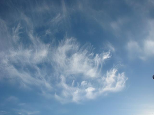
141 Do we need to change course? In the northern hemisphere we need to have the wind on the starboard side of the vessel, power or sail. If it is on the port side it means we are going closer to the centre of the Low, the centre of a storm? 141
142 In the Southern Hemisphere, the wind should be on the port side of the vessel to ensure movement is away from the centre of the Low where wind is strongest. If the wind is on the starboard side it will result in the vessel going into the centre of the Low. 142
143 How do we know if a Cold Front is coming? We know that when warm humid air is cooled below the Dew Point, i.e. when 100% humidity continues to cool, then condensation occurs. Clouds are seen... At the leading edge of the warm air we see cooling from the air ahead. As the cool air is not very cold, the speed of condensation is slow there is only little wind; these clouds are relatively smooth, Stratus. Cold Front, windy/rough clouds are Cumulus : 143
144 High level wind is fastest. Low level air is slowed by the slower earth rotation speed being further away from the equator. So there is a sloping edge of the Warm Front. Cooling air Fast Very cold Cold air Front Warm humid air Slow Slower Cool or colder air Faster Warm Front 144
145 Clouds above 8000 m are the High clouds, high = cirro. Clouds between 2000 m and 8000 m are the middle level clouds, middle = Alto. Clouds below 2000 m have no prefix. High Cirro s 8000 m Medium Alto s Cold Front Low 2000 m 145
146 The leading Warm Front clouds are smooth layer Stratus clouds where there is a smaller air temperature difference than at the cold front, due to slow condensation m Medium High Warm Front Cold Front Low 2000 m 146


147 For practical sailing purposes, names are not too important, but when first seeing the high clouds come over the horizon, then clouds getting lower, A FRONT IS COMING! Cirrus Cirrocumulus Cirrostratus Cumulonimbus Heavy rain Altocumulus Altostratus Stratocumulus Cumulus Stratus Nimbostratus (steady rain) 147


148 The highest Cirrus clouds see streaks: 148


149 Cirrocumulus high, small lumpy clouds:


150 Cirrostratus high hazy clouds. See the halo around the sun when seen through it. Other clouds seen below or above the smooth Cirrostratus. 150


151 Altocumulus any middle level lumpy clouds sometimes some types are seen in irregular sequence. 151


152 Altostratus middle level smooth and deep cloud nothing visible through it. Some other clouds seen above or below it. 152

153 Stratocumulus a dark layer of lumpy clouds, all are joined together and no sky or anything visible through them. It will not normally be long before rain starts. 153


154 Cumulus clouds usually with a flat dark bottom. If not part of the cold front clouds sequence, it normally will be indicating nice sailing speed Trade Wind, but here the wind was lighter. We were motoring!


155 Stratus mainly smooth and low clouds, with gaps between them. If at sea level, it is fog: 155
 to (right) starboard. We can only see the bottom of it approaching.")
156 Nimbostratus dark and rain imminent or it is raining here it was moving from port (left) to (right) starboard. We can only see the bottom of it approaching

157 Cumulonimbus a sight very rarely seen. Rain was pouring down under the bottom dark area to the right. We only see its side. 157
158 So when we see them: C B A As the Front approaches, the highest clouds are the first to rise over the horizon Your horizon D to the +/- WEST of you!!! You are here 158
159 A few hours later the next may be seen Your horizon C B A The next clouds are then rising over the horizon D The top clouds may have passed already. You are here 159
160 Often layers overlap - we see several. A Your horizon Later D C B Later lower clouds are seen rising over the horizon And this continues until the lowest are seen to arrive! You are here 160
161 The cirrus clouds of a front are usually(?!) about 500 n.m. ahead of the cold front. As clouds follow getting lower, the wind direction changes, as shown on pages 128 to 134. When we see the wind direction changes, clouds down to the lower levels, and the sky gets darker, rain is not far away. 161
162 However, while observing high clouds changing as lower clouds arrive, it may happen that suddenly there is a clear sky. If it stays clear, the front is going to pass to one side of you, not over you. Quite often we see that the clouds moving take a long time either they are moving slowly (maybe being blocked by a High pressure ahead) or each type is covering a long distance, and many may overlap. 162
163 Tropical Revolving Storms, T.R.S. s We have all heard of Hurricanes and Cyclones and we know they are the very strong winds of storms in the tropics, hence TRS s. Unlike normal ocean Lows formed in the polar front and which move west to east, in the tropics we have the easterly trade winds pushing the weather form east to west. So Lows moving east to west are to be regarded as TRS s unless proved not. 163
164 When wind speed is known to be over 54+ knots, it is termed a Tropical Depression. When it increases to over 64 knots it is a Tropical Storm, a Hurricane, a Cyclone, or a Typhoon. These occur here: Hurricanes Typhoons Cyclones 164
165 In the west of the North Pacific ocean they happen at any time. In the North Atlantic and east of the Pacific they are from June to December. Typhoons a, b, and c are April to July, September to January, and April to December!!! December to April c a b Cyclones: None! October to March 165
166 When seen on a synoptic chart, the inner symbols instead of an L for Low is for Tropical Depression; when it is upgraded it becomes. So we see they appear as: becomes and becomes They usually form at latitudes of about 10 plus, and in the eastern half of the ocean, then follow a general direction similar to the outer winds of the ocean high pressures. When curving up to latitudes of around 35 to 40, they then die away. Sometimes the route may be over islands and into land. 166
167 These are the more normal routes. At times they are like bad drivers; they go at extra speed where the should not! Cyclones normally occur between October and March/ December to April, but infrequently they do or may appear in any month. 167
168 The Path - the most dangerous quadrants to be avoided The Track The Path The Track - the second most dangerous quadrants; they are to be avoided. 168
169 Imagine the wind around these TRS s are at about 75 knots. Imagine also that the TRS s are moving east to west at 25 knots - the wind on the polar side will be = 100. On the equator side it is = 50 knots 75 knots 75 knots 25 knots 75 knots 25 knots 25 knots 75 knots 25 knots 169
170 So the equator side of the path is on the opposite side to the very dangerous quadrants and the wind will be about half the speed of the most dangerous side! Now we also need to know, in the northern hemisphere whether on a power boat or sailing, to move away and not towards the centre of the Hurricane the wind must be coming onto the starboard side of the vessel. In the southern hemisphere the wind must be on to the port side. Let s see 170
171 As the wind veers or backs, you want to be moving away, not towards the storm. Northern Hemisphere -wind to be on the starboard. Southern Hemisphere -wind to be on the port side. 171
172 Tornadoes occur when the condensation in cumulonimbus clouds is so intense, air rushes into the cloud from all directions. High speed winds rushing together from opposite directions start to spin, re-creating a very low pressure in the cloud. As it continues and increases, it starts to spiral down when the high speed rotating wind gets to the ground, it smashes anything and everything in its way. Objects get thrown up and away. If over water, a water spout tower occurs. 172
173 Inside a very low pressure area wind is pulled in from all sides wind in opposite directions starts fast spinning 173
174 When you see water starting to spin down into a basin s outlet, the top opening gets larger as the hole gets deeper In this cloud, the spinning also starts to work downwards. It will touch ground first as a pin! Then expand. Low level winds can be near 200 knots! 174

175 Three categories of Tornados: 1. Weak, +/- 10 mins, wind up to 95 knots. 2. Strong, up to 30 mins, wind up to 175 knots. 3. Violent, +/- 1 hour, winds more than Strong. Observe the size where it touches down about 200 m? The wind is VERY strong even miles away! 175
176 Thunderstorms occur in cumulonimbus clouds. The big difference in temperatures cause the warm humid air to experience rapid condensation. (Remember page 119, becomes.) When millions of these are happening at random in varying places, air is running in many directions at any one time, then another, then another, so air turbulence becomes excessive. This results in electrical voltage build-up. 176
177 The build up of electrical charge within the cloud becomes a different voltage to the earth below, and when a relatively lower resistance path through areas of vapour condensation occurs, electric current flows from the high voltage..(in the cloud) to the lower voltage..below. We can see the extremely.... hot electric flow burning the air as a very high current (amperes) discharges the high voltage. We see this: 177
178 The lightning high current flow spark only exists for a second, and a very short while later we hear a loud bang. All the air and vapour in its path have been burnt to nothing, leaving a tube shaped empty gap. Air around it now rushes in from all sides to fill this gap. As the air is moving in, it is accelerating. When air from opposite directions crash into each other, the resulting vibration of the air is at sound identifiable frequencies we hear the BANG. 178
179 The speed of sound at and near sea level and under normal conditions is 340 m/second. Therefore it takes: 3 seconds per kilometer, 5 seconds per mile, and 5.5 seconds per nautical mile. So when we see the lightning, then hear the sound, we can determine how close or far away it is. 179
180 Fog - when visibility is less than 1000 m due to sea level cloud. (We deal with Advection and Radiation fog.) 1. Advection fog. Whenever warm, humid air is cooled over the sea, and as a result the humidity reaches 100% or Due Point, any further cooling will cause condensation. The condensation that takes place appears as a cloud. If warm humid air moves over cold sea surface areas, condensation occurs at sea level and our visibility is reduced. 180

181 Each day as the sun crosses east to west near the equator, air and sea moving the same way heats up and humidity grows! H H Later, when the warm humid air circles around the High, it may eventually cross over cold sea where cooling and condensation may occur it is fog. 181
182 Fog at sea is called Advection Fog it can happen anywhere if there is cold sea and warm humid air. Once it is seen to start approaching, there are several safety actions to be applied: 1. Slow to a safe speed. 2. Start sound signals. 3. Lights on. 4. Crew on deck with lifejackets on or nearby, and all spread around to look for other vessels or anything affecting safety. 5. Radar on, and reflector up. 6. Radio your position, course, and speed to a marine station. 182
183 Inversion is a result of Fog. Normal air temperature is warmest at sea level. Air cools as height increases. Where fog occurs, the air over cold sea water cools, and therefore a warmer temperature is above the fog. From sea level fog, higher air s temperature rises, and thereafter as it goes even higher, normal cooling then occurs. Over fog where higher air warms, there is Inversion (of temperature change): 183
184 An illustration makes it easier to understand Inversion : Air temperature changes with height Cools Normal Coldest Colder Cold Cooler Cool Warm Warmer Warmest Cools Warms Inversion Coldest Colder Cold Cooler Cool Warm Warmer Cool/Cooler 184
185 2. Radiation Fog Fog also occurs over land called Radiation Fog. Humid air, often created by water vapour radiating from plants, if at high altitudes or where significant cooling occurs, may experience condensation fog. If it is cooler, heavier air than the warm air near sea level, so like a river, the fog flows down and may spill out to sea but only for a few miles before it starts evaporating. 185
186 Land and Sea Breezes Hot land next to a coast where there is cold sea, has air heating and rising during the day, and cool heavier air comes off the sea to fill the gap being created by rising hot air. A light wind blows from sea onto the land a Sea Breeze. At night, high level land s air gets colder and heavier than coast level warmer air the heavier air flows down and over the coast out to sea a few miles it is Land Breeze. Let s see 186
187 Sea Breeze Cold, heavier air moves into the space on land Cold sea THESE ONLY HAPPEN WHEN THERE IS NO ISOBAR WIND! +/- 5 n.m. Warmer Hot Hot air rises and leaves space. Land Breeze Colder, heavier air up on high ground flows down like a Colder river to lower warmer areas, and spills out to sea. 187
Understanding Weather
 Understanding Weather Images Graphic of the atmosphere. Enlarge Cirrus clouds. Enlarge Air masses Air masses are parcels of air that bring distinctive weather features to the country. An air mass is a
Air Pressure and Wind
 Air Pressure and Wind 19.1 Understanding Air Pressure Air Pressure Defined Air pressure is the pressure exerted by the weight of air. Air pressure is exerted in all directions down, up, and sideways. The
Chapter. Air Pressure and Wind
 Chapter Air Pressure and Wind 19.1 Understanding Air Pressure Air Pressure Defined Air pressure is the pressure exerted by the weight of air. 19.1 Understanding Air Pressure Air Pressure Defined Air pressure
18.1 Understanding Air Pressure 18.1 Understanding Air Pressure Air Pressure Defined Measuring Air Pressure Air pressure barometer
 18.1 Understanding Air Pressure 18.1 Understanding Air Pressure Air Pressure Defined Air pressure is the pressure exerted by the weight of air. Air pressure is exerted in all directions down, up, and sideways.
WEATHER SYSTEMS OF MIDDLE LATITUDES
 CHAPTER 10 WEATHER SYSTEMS OF MIDDLE LATITUDES MULTIPLE CHOICE QUESTIONS 1. In equal volumes, which one of the following air masses exerts the highest surface air pressure? a. cp *b. A c. mp d. ct e. mt
Heart of England Offshore Cruising Association HOEOCA
 Sailing Weather Penny Tranter 19 January 2017 Heart of England Offshore Cruising Association HOEOCA Weather and climate The difference between weather and climate? Weather is the state of the atmosphere
Wind is caused by differences in air pressure created by changes in temperature and water vapor content.
 Topic 8: Weather Notes, Continued Workbook Chapter 8 Wind is caused by differences in air pressure created by changes in temperature and water vapor content. Wind blows from high pressure areas to low
ATMOSPHERIC CIRCULATION. WIND = The horizontal movement of air. Results from the differences in air pressure. Always moves from HIGH to LOW.
 ATMOSPHERIC CIRCULATION WIND = The horizontal movement of air. Results from the differences in air pressure. Always moves from HIGH to LOW. Pressure differences result from variations in temperature. AIR
PHYSICAL GEOGRAPHY. By Brett Lucas
 PHYSICAL GEOGRAPHY By Brett Lucas ATMOSPHERIC PRESSURE AND WIND Atmospheric Pressure and Wind Atmospheric Processes The Nature of Wind General Circulation of the Atmosphere Modifications of General Circulation
Lesson: Atmospheric Dynamics
 Lesson: Atmospheric Dynamics By Keith Meldahl Corresponding to Chapter 8: Atmospheric Circulation Our atmosphere moves (circulates) because of uneven solar heating of the earth s surface, combined with
APPI PPG LECTURE 5: FURTHER METEOROLOGY
 LECTURE 5: FURTHER METEOROLOGY Introduction: This lecture covers Further Meteorology and aims to give you more of an understanding of advanced weather conditions and patterns. However Meteorology is a
Section 1. Global Wind Patterns and Weather. What Do You See? Think About It. Investigate. Learning Outcomes
 Chapter 5 Winds, Oceans, Weather, and Climate Section 1 Global Wind Patterns and Weather What Do You See? Learning Outcomes In this section, you will Determine the effects of Earth s rotation and the uneven
ATOMOSPERIC PRESSURE, WIND & CIRCULATION
 ATOMOSPERIC PRESSURE, WIND & CIRCULATION A. INTRODUCTION Important because: pressure patterns drive wind patterns which in turn drive oceanic circulation patterns o atmospheric & oceanic circulation: major
T. James Noyes, El Camino College Winds Unit (Topic 8A-1) page 1
 page 1") T. James Noyes, El Camino College Winds Unit (Topic 8A-1) page 1 Name: Section: Winds Unit (3 pts) The Ocean and the Atmosphere We need to learn about the atmosphere, because the ocean and atmosphere are
T. James Noyes, El Camino College Winds Unit (Topic 8A-1) page 1 Name: Section: Winds Unit (3 pts) The Ocean and the Atmosphere We need to learn about the atmosphere, because the ocean and atmosphere are
Weather questions. Question 1 (1 Mark) State what information is included in a cyclone warning.
 State what information is included in a cyclone warning.") Question 1 (1 Mark) Weather questions State what information is included in a cyclone warning. Question 2 (1 Mark) In which direction do winds travel around a high pressure system in the southern hemisphere?
Question 1 (1 Mark) Weather questions State what information is included in a cyclone warning. Question 2 (1 Mark) In which direction do winds travel around a high pressure system in the southern hemisphere?
What most affects a seaman s (and your) life? The Weather.?
 life? The Weather.?") What most affects a seaman s (and your) life? The Weather.? 1 Never go to sea without a weather forecast On land TV National radio Local radio Newspaper Teletext Web Mobile phone Barometer At sea BBC radio
What most affects a seaman s (and your) life? The Weather.? 1 Never go to sea without a weather forecast On land TV National radio Local radio Newspaper Teletext Web Mobile phone Barometer At sea BBC radio
Earth s Atmosphere. Earth s atmosphere is a key factor in allowing life to survive here.
 Chapter 10.2 Earth s Atmosphere Earth s atmosphere is a key factor in allowing life to survive here. This narrow band of air has the right ingredients and maintains the correct temperature, to allow life
Think it Over. Now that we have completed the activity, make any necessary changes to your prediction.
 Think it Over What do global wind patterns look like? Draw your prediction on your sheet. Now, let s try something. Does the wind turn? Let s find out! Now that we have completed the activity, make any
Meteorology. Circle the letter that corresponds to the correct answer
 Chapter 6 Worksheet 2 Meteorology Name: Circle the letter that corresponds to the correct answer 1) A steep pressure gradient: a. produces light winds. b. produces strong winds. c. is only possible in
Envs, Geol, Phys 112: Global Climate. Energy-Atmosphere System Review Aguado & Bert, Ch. 1, 2, 3, 4, 5, 6, 9, 10
 Exam 1 Review Energy-Atmosphere System Review Aguado & Bert, Ch. 1, 2, 3, 4, 5, 6, 9, 10 Location on Earth (L04) Latitude & Longitude great circles, prime meridian, time zones, cardinal points, azimuth
3 Global Winds and Local Winds
 CHAPTER 1 3 Global Winds and Local Winds SECTION The Atmosphere BEFORE YOU READ After you read this section, you should be able to answer these questions: What causes wind? What is the Coriolis effect?
Exploring Wind Energy
 2013-2014 Exploring Wind Energy Student Guide SECONDARY Introduction to Wind What is Wind? Wind is simply air in motion. It is produced by the uneven heating of the Earth s surface by energy from the sun.
CHAPTER 8 WIND AND WEATHER MULTIPLE CHOICE QUESTIONS
 CHAPTER 8 WIND AND WEATHER MULTIPLE CHOICE QUESTIONS 1. is the movement of air measured relative to the Earth's surface. a. Gravity b. The pressure gradient force c. The Coriolis Effect d. The centripetal
Weather EOG Review Questions
 Weather EOG Review Questions 1. Which statement best describes runoff? A Water vapor cools off and changes into water droplets. B Water in the form of rain, snow, sleet, or hail falls from clouds. C Precipitation
Meteorology I Pre test for the Second Examination
 Meteorology I Pre test for the Second Examination MULTIPLE CHOICE 1. A primary reason why land areas warm up more rapidly than water areas is that a) on land, all solar energy is absorbed in a shallow
SIO20 - Midterm Examination 2 v1 Winter Section A. Circle the letter corresponding to the best answer. (1 point each)
") NAME: Section A. Circle the letter corresponding to the best answer. (1 point each) 1. Rainbows result from: a. refraction and reflection of sunlight by water droplets b. reflection of sunlight by oceans
NAME: Section A. Circle the letter corresponding to the best answer. (1 point each) 1. Rainbows result from: a. refraction and reflection of sunlight by water droplets b. reflection of sunlight by oceans
Winds and Ocean Circulations
 Winds and Ocean Circulations AT 351 Lab 5 February 20, 2008 Sea Surface Temperatures 1 Temperature Structure of the Ocean Ocean Currents 2 What causes ocean circulation? The direction of most ocean currents
Atmosphere & Weather. Earth Science
 Atmosphere & Weather Earth Science Energy Transfer in the Atmosphere Earth s energy is provided by the SUN! Energy is important to us because it 1. Drives winds and ocean currents. 2. Allows plants to
3 Global Winds and Local Winds
 CHAPTER 15 3 Global Winds and Local Winds SECTION The Atmosphere BEFORE YOU READ After you read this section, you should be able to answer these questions: What causes wind? What is the Coriolis effect?
Section 6. The Surface Circulation of the Ocean. What Do You See? Think About It. Investigate. Learning Outcomes
 Chapter 5 Winds, Oceans, Weather, and Climate Section 6 The Surface Circulation of the Ocean What Do You See? Learning Outcomes In this section, you will Understand the general paths of surface ocean currents.
Chapter 22, Section 1 - Ocean Currents. Section Objectives
 Chapter 22, Section 1 - Ocean Currents Section Objectives Intro Surface Currents Factors Affecting Ocean Currents Global Wind Belts (you should draw and label a diagram of the global wind belts) The Coriolis
Length of day for a full year. Ocean Gyres. Wet. Adiabatic. lapse rate, starts at. dewpoint Dry Adiabatic lapse rate
 Vernal Equinox March 20, 11:57 AM, CDT Sun will rise exactly in the east and set exactly in the west. All latitudes get 12 hours of day and 12 hours of dark. Length of day for a full year Wet Adiabatic
Air Pressure and Wind. Goal: Explain the formation of wind based on differences in air pressure
 Air Pressure and Wind Goal: Explain the formation of wind based on differences in air pressure What is Air Pressure? Reminder: Air pressure is thickest near Earth s surface and becomes thinner as we move
Atmospheric Circulation
 Atmospheric Circulation Why do we say Earth's temperature is moderate? It may not look like it, but various processes work to moderate Earth's temperature across the latitudes. Atmospheric circulation
Unit Test Study Guide:
 Name: Homeroom: Date: Unit 6: Meteorology Study Guide Unit Test Study Guide: Atmosphere & Weather Use the summary points below as a resource to help you study for our unit test Monday! EARTH S ATMOSPHERE:
Chapter 7 Weather and Climate
 Chapter 7 Weather and Climate *Describe what weather is, what affects it, and where it occurs. *Explain the connection between air pressure and wind. * *Many factors affect a region s weather. * *atmosphere
Small- and large-scale circulation
 The Earth System - Atmosphere II Small- and large-scale circulation Atmospheric Circulation 1. Global atmospheric circulation can be thought of as a series of deep rivers that encircle the planet. 2. Imbedded
Chapter 6: Atmospheric Pressure, Wind, and Global Circulation
 Discovering Physical Geography Third Edition by Alan Arbogast Chapter 6: Atmospheric Pressure, Wind, and Global Circulation Factors That Influence Air Pressure Air Pressure is the measured weight of air
3 Global Winds and Local Winds
 CHAPTER 6 3 Global Winds and Local Winds SECTION The Atmosphere BEFORE YOU READ After you read this section, you should be able to answer these questions: What causes wind? What is the Coriolis effect?
6.9B verify through investigations that thermal energy moves in a predictable pattern from warmer to cooler 6.5B recognize that a limited number of
 6.9B verify through investigations that thermal energy moves in a predictable pattern from warmer to cooler 6.5B recognize that a limited number of elements comprise the largest portion of oceans and atmosphere
1.3: CLIMATE GEOGRAPHY. pgs
 1.3: CLIMATE GEOGRAPHY pgs. 76-89 INTRODUCTION WEATHER: Is the combination of temperature, precipitation, cloud cover and wind that we experience EACH DAY. Example: 22 0 C and clear skies. CLIMATE: The
AT350 EXAM #2 November 18, 2003
 AT350 EXAM #2 November 18, 2003 Name and ID: Enter your name and student ID number on the answer sheet and on this exam. Record your answers to the 50 questions by using a No. 2 pencil to completely fill
Learning Target: Today we will begin learning about weather systems and fronts.
 October 31st, 2014 Thank you for not chewing gum Materials: Pencil, science notebook, Science book Today s Agenda: Bell work Vocabulary quiz Finish reading 3.1 Notes Learning Target: Today we will begin
instructors official training aid APPROVED TRAINING AID
 instructors official training aid WIND WINDOW FIGURE OF EIGHT Power Zone Flying the kite in a figure of eight is how you generate power WIND DIRECTION Off Shore Cross Off Shore Cross Off Shore Cross Shore
ESCI 107/109 The Atmosphere Lesson 9 Wind
 Reading: Meteorology Today, Chapter 8 ABOUT WIND Wind is the motion of the air. ESCI 107/109 The Atmosphere Lesson 9 Wind The direction of the wind is given by which direction it is blowing from. For example,
Global Winds and Local Winds
 Global Winds and Local Winds National Science Education Standards ES 1j What is the Coriolis effect? What are the major global wind systems on Earth? What Causes Wind? Wind is moving air caused by differences
Chapter 8 Air Masses
 Chapter 8 Air Masses Air Masses - 1 1. An Air Mass is a large body of air usually about 1500 km across and several km thick, that has homogeneous physical properties. 2. The important physical properties
Carolina TM Coriolis Effect and Atmospheric Circulation Kit STUDENT GUIDE
 Name: Date: Mods: Carolina TM Coriolis Effect and Atmospheric Circulation Kit STUDENT GUIDE Background Global air circulation is a major influence on the world's climates. Air circulation is caused by
What Causes Different Weather?
 What Causes Different Weather? Table of Contents What causes weather?...3 What causes it to rain or snow?...4 What causes flooding?...5 What causes hail?...6 What causes the seasons?...7-8 What causes
Class Notes: Week 10. April 9 th,2019. Topics: Front and Mid-Latitude Wave Cyclones El Niño / La Niña Mid-term 2 review
 Class Notes: Week 10 April 9 th,2019 Topics: Front and Mid-Latitude Wave Cyclones El Niño / La Niña Mid-term 2 review Front- is a boundary between 2 different types of air masses Air masses with different
Canada s vast size creates a diverse range of weather conditions and climatic conditions. Warming trend for last 10 years Wet Spring Dry five summers
 Chapter 4 Weather and Climate Canada s vast size creates a diverse range of weather conditions and climatic conditions. Weather examples: Rainy today Snow tomorrow Fog on Wednesday 23 degree C today High
Summary of Lecture 10, 04 March 2008 Introduce the Hadley circulation and examine global weather patterns. Discuss jet stream dynamics jet streams
 Summary of Lecture 10, 04 March 2008 Introduce the Hadley circulation and examine global weather patterns. Discuss jet stream dynamics jet streams arise because the Coriolis force prevents Hadley-type
Lecture 8: Pressure and Wind
 Lecture 8: Pressure and Wind Pressure Distribution Forces Affect Wind Earth s Rotation Coriolis Force Geostrophic Balance Energy (Heat) The first law of thermodynamics Air Temperature Air Pressure Air
Finish Characteristics of Climate
 Bell Ringer Finish Characteristics of Climate Wind Coriolis Effect Newton s second law: a body in motion will continue in motion (unchanged) unless acted upon by an outside force. Liquid (water) and gas
The Atmosphere and Winds
 Oceanography 10, T. James Noyes, El Camino College 8A-1 The Atmosphere and Winds We need to learn about the atmosphere, because the ocean and atmosphere are tightly interconnected with one another: you
8 th Grade Science Meteorology Review
 8 th Grade Science Meteorology Review #1 Where does Earth get the energy that produces global weather patterns? A: The sun B: Humidity C: Air masses D: Cyclones A. The Sun #2 Do all of the areas on Earth
ATMOSPHERIC CIRCULATION
 Name ATMOSPHERIC CIRCULATION (adapted from Dr. S. Postawko, U. of Ok.) INTRODUCTION Why does the wind blow? Why do weather systems in the mid-latitudes typically move from west to east? Now that we've
Write answers on your own paper. A. the Sun B. the Moon C. Earth s gravity D. Earth s rotation
 The tmosphere Write answers on your own paper 1. What is the primary energy source that drives all weather events, including precipitation, hurricanes, and tornados?. the Sun. the Moon C. Earth s gravity
Wind and Wind Patterns
 Wind and Wind Patterns What is Weather? Weather is the condition of Earth s atmosphere at a particular time and place. What is Wind? Wind is air moving across the surface of the Earth. It can move horizontally
10.2 Energy Transfer in the Atmosphere
 10.2 Energy Transfer in the Atmosphere Learning Outcomes Understand the different layers of the atmosphere Understand how energy moves in, out, and around our atmosphere er Composi
Prevailing Winds. The Coriolis Effect
 Prevailing Winds 1. Wind: a movement of air in the atmosphere. Bill Nye wind (2 minutes) 2. Local or regional wind: occur in fairly small areas. 3. Prevailing winds: Major wind pattern that affect large
Weather and Climate. Climate the situation of the atmosphere during a long period of time and a big surface.
 Weather and Climate Weather and Climate Weather the situation of the atmosphere during a short period of time and a small surface of the Earth. It is very irregular and changes a lot. Climate the situation
Water on Earth. How do oceans relate to weather and the atmosphere? Solar Radiation and Convection Currents
 Earth is often called the Blue Planet because so much of its surface (about 71%) is covered by water. Of all the water on Earth, about 96.5% is held in the world s oceans. As you can imagine, these oceans
IN THE TABLE OF CONTENTS AND ON THE NEXT CLEAN PAGE, TITLE IT: WIND NOTES WIND!
 IN THE TABLE OF CONTENTS AND ON THE NEXT CLEAN PAGE, TITLE IT: WIND NOTES WIND! Wind 8.10A recognize that the Sun provides the energy that drives convection within the atmosphere and oceans, producing
Weather and Meteorology Sheet 1 Adiabatic Processes The definition is:- A system where heat is neither added nor taken from a process.
 Weather and Meteorology Sheet 1 Adiabatic Processes The definition is:- A system where heat is neither added nor taken from a process. The expansion and compression of gases are adiabatic. Consider the
Earth s Atmosphere. Air Currents
 CHAPTER 12 Earth s Atmosphere LESSON 3 Air Currents What do you think? Read the two statements below and decide whether you agree or disagree with them. Place an A in the Before column if you agree with
Full Name: Class: Period: Date:
 Topic/Objective: Essential Question: Full Name: Class: Period: Date: Tutor Use Only: Air Pressure and Wind (Chapter 19) Air Pressure the weight of the atmosphere pushing down on the Earth exerting a force
Chapter 9: Circulation of the Ocean
 Chapter 9: Circulation of the Ocean Tropical gardens on Britain s Scilly Isles. Only 48 kilometers (30 miles) off the coast of Cornwall at 50 N, these scenic islands lie in the path of the warm waters
Canada s Natural Systems. Canadian Geography 1202
 Canada s Natural Systems Canadian Geography 1202 Canada s Natural Systems Natural System: A system found in nature Here are the four natural systems that we will explore in the next few weeks 1. Canada
Wind Patterns on Earth
 Wind Patterns on Earth What causes air to move? Air pressure differences causes air to move. These differences in air pressure at the same altitude is caused by uneven heating of the Earth s surface. With
Local Winds & Microclimates. Unit 2- Module 1
 Local Winds & Microclimates Unit 2- Module 1 Objectives Overview of local winds (sea & land breezes, valley winds) Overview of microclimates (valley, urban, woodland) Local Winds Local Winds Local winds
Foundations of Earth Science, 6e Lutgens, Tarbuck, & Tasa
 Foundations of Earth Science, 6e Lutgens, Tarbuck, & Tasa The Atmosphere in Motion Foundations, 6e - Chapter 13 Stan Hatfield Southwestern Illinois College Atmospheric pressure Force exerted by the weight
Only launch your boat once you have a clear understanding of the most up-to-date weather forecast.
 Weather and Tides Observing the Weather Only launch your boat once you have a clear understanding of the most up-to-date weather forecast. Start with television and newspaper weather map reports; they
McKnight's Physical Geography 11e
 Chapter 2 Lecture McKnight's Physical Geography 11e Lectures Chapter 5 Atmospheric Pressure and Wind Michael Commons Ohio Northern University Atmospheric Pressure and Wind The Nature of Atmospheric Pressure
Wednesday, September 27, 2017 Test Monday, about half-way through grading. No D2L Assessment this week, watch for one next week
 Wednesday, September 27, 2017 Test Monday, about half-way through grading No D2L Assessment this week, watch for one next week Homework 3 Climate Variability (due Monday, October 9) Quick comment on Coriolis
Lesson: Ocean Circulation
 Lesson: Ocean Circulation By Keith Meldahl Corresponding to Chapter 9: Ocean Circulation As this figure shows, there is a connection between the prevailing easterly and westerly winds (discussed in Chapter
Name Date L.O: SWBAT explain what breezes, planetary winds, ocean currents & monsoons are.
 Name Date L.O: SWBAT explain what breezes, planetary winds, ocean currents & monsoons are. 1. A cool breeze is blowing toward the land from the ocean on a warm, cloudless summer day. This condition is
Chapter 13 Lecture Outline. The Atmosphere in Motion
 Chapter 13 Lecture Outline The Atmosphere in Motion Understanding Air Pressure Air pressure is the force exerted by weight of air above Weight of the air at sea level 14.7 psi or 1 kg/cm 2 Decreases with
Greenhouse Effect Activity
 Greenhouse Effect Activity Objectives: The student will: 1. Read and use weather instruments. 2. Collect and record temperature readings. 3. Describe the concept of the greenhouse effect. Materials: Fish
Assessment Schedule 2016 Earth and Space Science: Demonstrate understanding of processes in the ocean system (91413)
") NCEA Level 3 Earth & Space Science (91413) 2016 page 1 of 6 Assessment Schedule 2016 Earth and Space Science: Demonstrate processes in the ocean system (91413) Evidence Statement Q Evidence with with Excellence
NCEA Level 3 Earth & Space Science (91413) 2016 page 1 of 6 Assessment Schedule 2016 Earth and Space Science: Demonstrate processes in the ocean system (91413) Evidence Statement Q Evidence with with Excellence
Weather Unit Study Guide
 Weather Unit Study Guide - 2018 Weather vs Climate What does weather measure? The condition of the earth's atmosphere at a particular time and place. How are climate and weather different? Climate is the
Atmospheric Circulation. Recall Vertical Circulation
 Today s topics: Atmospheric circulation: generation of wind patterns on a rotating Earth Seasonal patterns of climate: Monsoons and Sea Breezes Tropical Cyclones: Hurricanes and typhoons Atmospheric Circulation
6.9B verify through investigations that thermal energy moves in a predictable pattern from warmer to cooler 6.5B recognize that a limited number of
 6.9B verify through investigations that thermal energy moves in a predictable pattern from warmer to cooler 6.5B recognize that a limited number of elements comprise the largest portion of oceans and atmosphere
The ocean water is dynamic. Its physical
 CHAPTER MOVEMENTS OF OCEAN WATER The ocean water is dynamic. Its physical characteristics like temperature, salinity, density and the external forces like of the sun, moon and the winds influence the movement
Atmospheric Circulation (Ch. 8) Ocean & Atmosphere are intertwined Gases & waters freely exchanged Wind Weather Climate
 Ocean & Atmosphere are intertwined Gases & waters freely exchanged Wind Weather Climate") Atmospheric Circulation (Ch. 8) Ocean & Atmosphere are intertwined Gases & waters freely exchanged Wind Weather Climate Atmospheric Structure Consists of Layers Separated by Temperature Stratosphere: Temperature
Atmospheric Circulation (Ch. 8) Ocean & Atmosphere are intertwined Gases & waters freely exchanged Wind Weather Climate Atmospheric Structure Consists of Layers Separated by Temperature Stratosphere: Temperature
Air Masses and Fronts
 Air Masses and Fronts A huge body of air that has similar temperature, humidity, and air pressure at any given height is called an air mass. A single air mass may spread over millions of square kilometers
Directed Reading. Section: Ocean Currents. a(n). FACTORS THAT AFFECT SURFACE CURRENTS
. FACTORS THAT AFFECT SURFACE CURRENTS") Skills Worksheet Directed Reading Section: Ocean Currents 1. A horizontal movement of water in a well-defined pattern is called a(n). 2. What are two ways that oceanographers identify ocean currents? 3.
Skills Worksheet Directed Reading Section: Ocean Currents 1. A horizontal movement of water in a well-defined pattern is called a(n). 2. What are two ways that oceanographers identify ocean currents? 3.
Higher Atmosphere. Earth s Heat Budget. Global Insolation. Global Transfer Of Energy. Global Temperatures. Inter Tropical Convergence Zone
 Higher Atmosphere Earth s Heat Budget Global Insolation Global Transfer Of Energy Global Temperatures Inter Tropical Convergence Zone Climate Graph Earth s Heat Budget Task 1 Use the Power Point to help
Isaac Newton ( )
") Introduction to Climatology GEOGRAPHY 300 Isaac Newton (1642-1727) Tom Giambelluca University of Hawai i at Mānoa Atmospheric Pressure, Wind, and The General Circulation Philosophiæ Naturalis Principia
Introduction to Climatology GEOGRAPHY 300 Isaac Newton (1642-1727) Tom Giambelluca University of Hawai i at Mānoa Atmospheric Pressure, Wind, and The General Circulation Philosophiæ Naturalis Principia
Lecture Outlines PowerPoint. Chapter 18 Earth Science 11e Tarbuck/Lutgens
 Lecture Outlines PowerPoint Chapter 18 Earth Science 11e Tarbuck/Lutgens 2006 Pearson Prentice Hall This work is protected by United States copyright laws and is provided solely for the use of instructors
Wind in the Atmosphere
 Lesson 2 Wind in the Atmosphere ESSENTIAL QUESTION What is wind? By the end of this lesson, you should be able to explain how energy provided by the sun causes atmospheric movement, called wind. p 6.ESS2.2,
Lornshill Academy. Geography Department Higher Revision Physical Environments - Atmosphere
 Lornshill Academy Geography Department Higher Revision Physical Environments - Atmosphere Physical Environments Atmosphere Global heat budget The earth s energy comes from solar radiation, this incoming
6.1 Introduction to Weather Weather air mass Weather factors Temperature Pressure What is wind? Wind Convection in the atmosphere Thermals thermal
 6.1 Introduction to Weather Weather is a term that describes the condition of the atmosphere in terms of temperature, atmospheric pressure, wind, and water. The major energy source for weather events is
9/25/2014. Scales of Atmospheric Motion. Scales of Atmospheric Motion. Chapter 7: Circulation of the Atmosphere
 Chapter 7: Circulation of the Atmosphere The Atmosphere: An Introduction to Meteorology, 12 th Lutgens Tarbuck Lectures by: Heather Gallacher, Cleveland State University Scales of Atmospheric Motion Small-
SESSION THREE: FACTORS THAT INFLUENCE WEATHER IN SOUTH AFRICA
 SESSION THREE: FACTORS THAT INFLUENCE WEATHER IN SOUTH AFRICA KEY CONCEPTS: In this section we will focus on the following aspects: Factors determining the weather of South Africa Influence of the oceans
Copy and answer the following in your marble composition book. 1. Which direction is the wind deflected in the northern hemisphere?
 Copy and answer the following in your marble composition book. 1. Which direction is the wind deflected in the northern hemisphere? 2. Which direction is the wind deflected in the southern hemisphere?
Chapter 10: Global Wind Systems
 Chapter 10: Global Wind Systems Three-cell model of atmospheric circulation Intertropical Convergence Zone (ITCZ) Typical surface wind patterns Upper-level pressure and winds Climatological sea-level pressure
100, precipitation Droplets, collide -40 C
 Warm-up 1/8 Page: 556, 1. A cloud droplet must increase in diameter by about times to fall as. 100, precipitation Page: 556, 2. Coalescence is when larger drift downward, then and combine with smaller
The student will be expected to demonstrate an understanding of the cause of winds and how winds affect climate.
 The student will be expected to demonstrate an understanding of the cause of winds and how winds affect climate. In this lesson you will: 2.3.1 Define the term prevailing winds. (k) 2.3.3 State the impact
Duckies have been found in Hawaii, Alaska, S. America, Scotland, Washington state and Australia as of 2012.
 Duckies have been found in Hawaii, Alaska, S. America, Scotland, Washington state and Australia as of 2012. We learned that it takes 3 years to complete one circuit of the North Pacific Gyre flow in the