Library founded at Alexandria 300 B.C.E
|
|
|
- Daniela Carpenter
- 5 years ago
- Views:
Transcription

1 Phonecians 1200 BC Origins begin as a mystery Located in western, costal part of fertile crescent Known for ships and manufacture of luxury and common goods

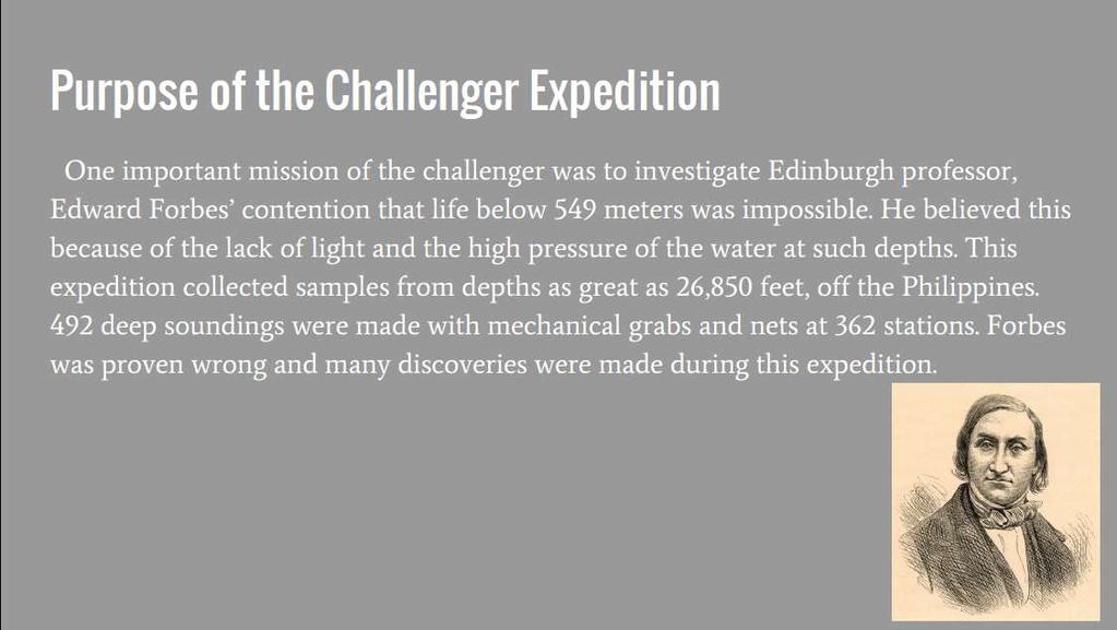
2 Library founded at Alexandria 300 B.C.E *The Royal Library of Alexandria was once the largest library in the world. *It was a major library and cultural center located on the shore of the Mediterranean Sea in the Egyptian city of Alexandria.

3 Latitude & Longitude *Latitude lines never intersect but they run East and West. Zero degrees parallel is the Equator. The equator measures distances only by Degrees. Longitude line run North & South. Zero degrees meridian is also know as The Line Of Longitude. The Prime Meridian measures distance using Degrees.

4 The Ancient Polynesians By Michael Abraham Ancient uses & Explorations 2000 and 500 B.C.

5 Culture and Location The Polynesian culture was a seafaring culture focused on oceanic exploration The Polynesians originally traveled by canoe around the islands of New Guinea Due to grater distance between Islands as exploration increased they developed double hauled vessels, capable of hauling colonists and supplies. With this new technology in transportation they then had to advance their navigation techniques, which led to a highly sophisticated system based on the stars, ocean swells, birds flight patterns and natural landmarks.

6 Exploration With new technology and navigation, the Polynesians went to explore on from new Guinea onto new lands in the North, East, South and West. From New Guinea the Polynesians reached islands such as Fiji, the northern Hawaiian Islands, Easter Island, and New Zeland. The reaches of Polynesian exploration and expansion is now known as and area called the Polynesian Triangle.
7 Links
8 Ancient Greek Explorations and Discoveries
9 It was primarily the ancient Greeks who first used mathematical principles and sophisticated maps for seafaring. By applying their advancements in early science and mathematics, this culture contributed to understanding the oceans in many ways. Although western civilization would lose the knowledge during the Middle Ages, the Greeks knew that the world was a sphere and not flat.
 calculated the Earth s circumference and invented the first lattitude/longitude system a system of imaginary lines on the Earth, used for navigation and mapping.")
10 The Greek Pytheas noted that he could predict the tides in the Atlantic based on the phases of the moon. About 150 years later, Eratosthenes ( B.C.) calculated the Earth s circumference and invented the first lattitude/longitude system a system of imaginary lines on the Earth, used for navigation and mapping. Hipparchus invented a better system the one used today later.
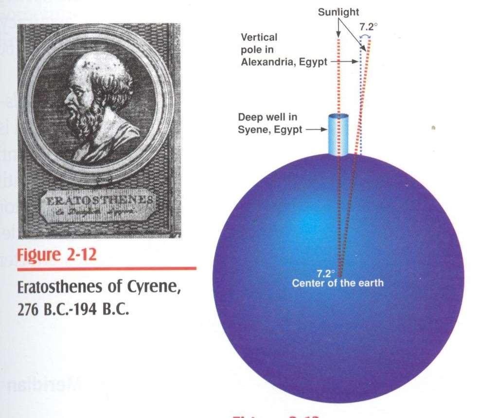
11 Eratosthenes of cyrene
12

13
14 Chinese Exploration and discoveries Daniel Probst
15 By AD 10150, Chinese navigators were using the float compass. In 1070, the Chinese developed dry docks for their ships. In the 13 th century Chinese ships ventured to India and occasionally to East Africa. Artifacts found on the Pacific Shores of America suggest the Chinese reached America before Columbus died. Chinese invented the magnetic compass around 1125 AD Chinese seafaring well established by about 1000 AD By the mid 1400 s they were well established ship builders
16 Prince henry the navigator By Devon Elkhay

17 ... This is the area that Prince henry traveled from Africa. This started the Slave Trade after a few Years. Prince henry the navigator is the son of the Portugal king. He was the third surviving son of King John I and Philippa of Lancaster. Henry is often credited with beginning the Age of Discovery, the period during which European nations expanded their reach to Africa, Asia and the Americas. Henry himself was neither a sailor nor a navigator, his name just being a title.

18 Prince Henry Henry died in 1460 in Sagres, Portugal. By the time of his death, Portuguese explorers and traders had advanced as far as the region of modern-day Sierra Leone. It would be another 28 years before Vasco de Gama, under the Portuguese flag, would sail clear around Africa and complete an expedition to India.
19 Christopher Columbus by:jett Lathrop
20 Christopher Columbus, a master mariner is most known for discovering the New World. The Vikings had actually discovered the Americas 500 years earlier. Columbus purpose was to find a new trading route to India, hence him naming the natives Indians. Columbus had assumed that the Earth was only HALF of it s actual size. He even died beliving that he had discovered islands off the coast of Asia, not realizing the massive impact he had.
21 Ferdinand Magellan-1519 First to Circumnavigate the globe While his expedition was successful, Ferdinand died during the travel

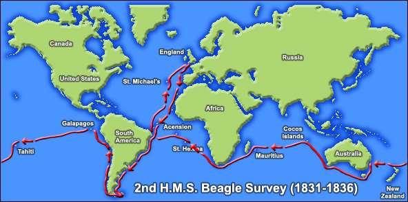
22 James cook

23 Key points James Cook (1700's) was one of the first explorers to make scientific observation Also considered first marine scientist Used a chronometer He took many samples of marine life, land plants, animals, the ocean floor, and geological formations He was very accurate and precise on all of his work
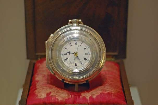
24 John Harrison/ Longitude Determination Skye Roa period 3
25 John Harrison/Longitude Determination John Harrison invented the Chronometer Chronometers were first developed for marine navigation and to determine longitude James Cook was a British explorer and was one of the first explorers to make scientific observations in the 1700 s James cook used a Chronometer on his expeditions
26 Chronometer
27 United States Exploring Expedition Ben McCann P3
28 A.K.A Wilkes Exploration Went on for 4 years ( ) Discovered the west coast of Antarctica First to ever leave the U.S. shores First to be commanded by an officer of the U.S. Navy Consisted of 6 sailing vessels and 346 men Wanted to Extend the bounds of science Discovered and brought back many new species
29 Matthew Maury Matthew Maury discovered worldwide patterns of wind and ocean currents Considered to be the father of oceanography US naval officer, an established authority who published many works on sea navigation and his journeys Published the first textbook on modern oceanography
30 Darwin & the H.M.S Beagle By: Aaron Oppelt P.3 H.M.S (He/She, Majesty s Ship)
31 Summary By the 19 th century, masts and sails were common on vessels The most famous of these types of vessels are brigs In 1831 Darwin began the voyage to map South America Darwin made detailed observations about animal life in different environments Some of Darwin s special interests were: natural history and science that was supported by his love for hiking, reading and chemistry

32 Pictures
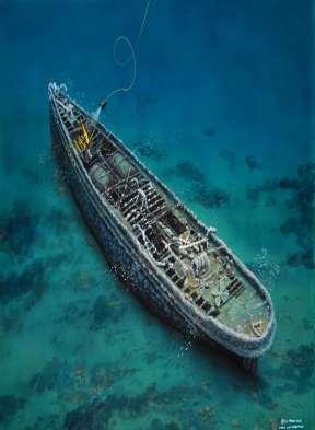
33 The Challenger Expedition

34
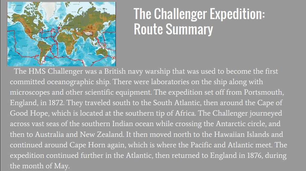
35
36

37 Military Applications to Ocean Exploration There are a lot of things that have to do with the ocean exploration that help the military, such as UWSNs (underwater sensor networks) By 1900 the industrial revolution had helped to expand oceanography as a science with the invention of the steam engine and iron ships. War has been a major contributing factor in the oceanography explosion.

 Iron ships also tremendously helped the military. Iron ships are just what they sound like. They are large ships made of iron.")
38 Steam Engines and Iron Ships Steam engines and iron ships were part of the first inventions that helped the military. Steam engines are machines that perform tasks mechanically by using steam as fuel. These helped the military because they could transport things from one place to another. (Steam engines look and act like trains.) Iron ships also tremendously helped the military. Iron ships are just what they sound like. They are large ships made of iron. These also helped the military transport things from one place to another.

39 UWSNs UWSN = underwater sensor networks UWSNs are just one example of how ocean explorations have aided the military. UWSNs are used to enable applications for oceanographic data collection, pollution monitoring, disaster prevention, etc.

40 By: Reese Campbell Polar Exploration

41 Fridtjof Nansen (October 10, 1861-May 13, 1930) Norwegian explorer, scientist, and Nobel Peace Prize winner Led the North Pole expedition in 1893 Nansen first began to consider the possibility of reaching the North Pole by using the natural drift of polar ice Set sail on the Fram in 1893 Became trapped in the ice with 13 crew members and drifted with the ice for over 3 years covering 1025 miles


42 Fridtjof Nansen Impact on Marine Science Proved that the Arctic continent existed His techniques of polar travel, equipment, and clothing influenced future Artic explorations and discoveries
43 The H.M.S challenger 2 By: Deniro dumas Period: 3 Marine Science
44 Facts The challenger came around December 1872 and May 1876 The ship was 200 feet with 17 guns The challenger began its voyage by crossing the Atlantic four times and visited Africa, Antarica, New Zeland, and etc And the challenger didn t just study the ocean but also Islands

45 The Trip

46 The Challenger Ship
47 Summary The challenger 2 was a ship that was built to explore sea and islands going through rough conditions like water pressure and lack of oxygen but was the first to attempt exploring the vast body of water and manage to discover 4,000 unknown species but eventually it come to a end in 1876
48 Ocean Drilling Rachel Broadbent P3

49 The Ocean Drilling Program(ODP) The ODP was an international and group mission to disclose and study the structure, matter composition on the Earth s ocean fundamental basis. Drilling discoveries have led to further hypotheses and questions in Earth sciences.

50 Important impacts Animals such as birds and sea turtles have a destroyed habitat from the construction of new oil pipes. Contaminated sediments are pushed by the current into fish populations, which reduced the population as a whole.

51 Pros It s important we have ocean drilling because oil is one of the most fundamental needs in the world today. Its needed for plastic and fuel.
52 Sources
53 Oceanographic Institutions By: Sarah Shack Period 3
54 Albert s Institut Océanographique The first institution was founded by Prince Albert I of Monaco who gave his countries oceanographic laboratory and museum in 1906 Most famous alumnus of the Institute was Jacques Cousteau In addition Monaco became the place of the International Hydrographic Bureau, founded in 1921 The bureau published one of the first general charts of the ocean showing bottom contours
55 3 Preeminent Oceanographic Institutions Woods Hole Oceanographic Institution: located on Cape Cod founded in 1921 (affiliated with the Massachusetts Institute of Technology and the neighboring Marine Biological Laboratory, founded in 1888) The Scripps Institution of Oceanography: located in La Jolla, California founded in 1903 (affiliated with the University of California in 1912 The Lamont-Doherty Earth Observatory of Columbia University: located in Palisades, New York founded in 1949

56 NOAA The National Oceanic and Atmospheric Administration Found in the department of commerce in 1970 Includes the National Ocean Service, National Weather Service, National Marine Fisheries Service, The Office of Sea Grant Trying to facilitate commercial uses of the ocean
57 Submersibles Submersibles are tiny mobile research vessels that are designed for exploration of the oceans depths. They can be manned or unmanned. During the late 1950s and 1960s a great variety were developed, but the first submersible was launched in the1930s. They were needed to make direct observations and measurements, recover lost equipment, and for possible rescue activity.

58 Bathysphere: 1 st Type Of Submersible A Bathysphere is a manned spherical chamber for deep sea observation, lowered and raised by a cable from a ship. It cannot operate in great ocean depths and cannot move from side to side. The first one was launched in 1930.

59 Bathyscaphe: 2 nd Type Of Submersible A Bathyscaphe was designed in the 1940s, after the Bathysphere. It s different from the Bathysphere because it s not connected by a cable to the ship. It has water chambers to make the craft sink, and gasoline chambers to make the craft float. To get to the surface after exploration, the Pilot drops iron pellets stored in the bottom of the craft. Once launched, it is self propelled.
. The Challenger is made up of a light but sturdy foam that is a substitute for steel. Gasoline tanks are not needed because the foam floats.")
60 The Deep Sea Challenger: Latest technology In 2012, scientists used The Deep Sea Challenger for exploring the deepest parts of the ocean including the Mariana Trench(more than 35,000 feet below the ocean s surface). The Challenger is made up of a light but sturdy foam that is a substitute for steel. Gasoline tanks are not needed because the foam floats. This design allows the Pilot to spend more time on the bottom of the ocean because it descends and ascends faster than the Bathyscaphes.
61 Summary Because of Submersibles, people have been able to explore the ocean floor. By inventing new types of technology over the years, people can explore sealife longer and faster than the previous technology.
62 Self-contained diving History & scientific purpose of SCUBA diving.

63 Origin of scuba diving Also known as SCUBA (Self-Contained Underwater Breathing Apparatus), Scuba devices are used to explore the deep ocean floor, without the use of higher & more expensive technology, such as submarines. The earliest self-contained apparatus dates back to about 375 AD, with heavy innovations being brought upon nearly 300 years ago. Augustus Siebe introduced the hard hat diving equipment in 1840, while Henry Fleuss introduced the 1 st workable SCUBA in The Aqua-Lung, one of the earliest versions of SCUBA, was first to reach popularity & commercial success.
64 Pros & cons of scuba diving Positive Factors Include: - Minimalistic equipment allows for easier traversing on land & in water. - Able to operate with little to no crew with you. - Divers have a large amount of freedom to move around underwater. Negative Factors Include: - Limited dive time due to limited oxygen. - Lack of communication between divers & other divers/authorities on boat. - Limited depth travel when compared to submarines & other aquatic machinery


65 Purpose of self-contained diving Not only is self-contained diving used for scientific purposes, but also for military work, sporting, industrial use, & commercially learning. Many scientific discoveries & advancements have occurred due to the hundreds of years of scuba diving, due to the quick progression of the technology & equipment. Such as an incredible ship wreck discovery that ages back 3,200 years ago in Croatia, & elongated skulls found in a Mayan underwater cave that scientists still have no answer to.

66 Robot Devices Remotely operated vehicles

67 Long Range Navigation (LORAN) Invented and first used in World War II Newest version is the LORAN-C, invented in 1970s Measured distance by time (in microseconds) signals took to transfer between devices Master LORAN systems would serve as a constant in one location, while secondary, or slave systems would send signals of their locations to the master system. Phased out by U.S. and Canada in 2010 in favor of Satellite-based GPS systems.

68 Global Positioning System (GPS) Rather than receiving signals from other transmitters, GPS uses satellites, ground stations, and receivers to transmit information. Satellites always stay in one position around the Earth, so we always know where they are Ground stations keep track and locate satellites. Receivers would read satellite signals and measures distance between itself and the satellite GPS replaced LORAN because it was a more precise method of location, with high-tech GPS systems being able to find a signal from within a fraction of an inch, as well as being able to see more of the planet with less systems tracking it.

69 Marine Archaeology Grant Roberts
70 What is Marine Archaeology? In plain terms it is the study and human interaction with any body of water. Marine Archaeology helps study the history of the ocean and aids in our understanding of it s beginning
71 Nautical Archaeology Probably the most relevant type of marine archaeology. Nautical Archaeology studies the remains of underwater shipwrecks. It studies the age of ships and the reason for sinking. Also involves the construction of the ship.


72 What does an archaeologist look like? Most, if not all marine archaeologists are veteran scuba divers.
Unit 1 Learning Goal: I will understand the history, technology, and scientific processes involved in Marine Science.
 Unit 1: Unit 1 Learning Goal: I will understand the history, technology, and scientific processes involved in Marine Science. Lesson 1.1: *Refer to Chapter 2 in your Textbook Lesson 1.1 Learning Targets:
Ocean Exploration. Copyright 2012 LessonSnips
 Ocean Exploration Approximately 71 percent of the surface of the earth is covered by the ocean yet very little of the ocean has been explored. Once sailing ships capable of traversing the ocean were built,
Introduction to Marine Science
 Chapter 1 Introduction to Marine Science Marine Science and Oceanography Marine Science: the process of discovering i the facts, processes, and unifying principals that explain the nature of the oceans
Chapter 1. The Science of Marine Biology - Why is it important? Marine Biology. The scientific study of the organisms that live in the sea
 Chapter 1 The Science of Marine Biology - Why is it important? Marine Biology Marine Biology - The scientific study of the organisms that live in the sea 1 Practical Reasons to study marine biology Vast
History/Explorers/Expeditions/Technology Webquest!
 Name Block History/Explorers/Expeditions/Technology Webquest! http://www.divediscover.whoi.edu/history-ocean/21st.html Click on: History of Oceanography (on the left side of the page) 1. Oceanography may
Overview. 70.8% of Earth covered by ocean 97.2% of surface water Interconnected global or world ocean
 Overview 70.8% of Earth covered by ocean 97.2% of surface water Interconnected global or world ocean Principal oceans Pacific Largest, deepest Atlantic Second largest Indian Mainly in Southern Hemisphere
Maritime Exploration THE EARLY MODERN WORLD ( )
") Maritime Exploration THE EARLY MODERN WORLD (1450 1750) An important theme of 1450 1750 (The Early Modern World) will be the effects of European exploration on the world. However, there were maritime expansions
Maritime Exploration THE EARLY MODERN WORLD (1450 1750) An important theme of 1450 1750 (The Early Modern World) will be the effects of European exploration on the world. However, there were maritime expansions
OCN 201. History of Oceanography and Polynesian voyaging
 OCN 201 History of Oceanography and Polynesian voyaging History of Settlement: Fiji by ~ 1300 BC Tonga by ~1100 BC Samoa and Marquesas by 500 BC By now there is a distinct Polynesian culture. Easter Island
OCN 201. History of Oceanography and Polynesian voyaging
 OCN 201 History of Oceanography and Polynesian voyaging History of Settlement: Fiji by ~ 1300 BC Tonga by ~1100 BC Samoa and Marquesas by 500 BC By now there is a distinct Polynesian culture. Easter Island
OCN 201. History of Oceanography and Polynesian voyaging
 OCN 201 History of Oceanography and Polynesian voyaging History of Settlement: Fiji by ~ 1300 BC Tonga by ~1100 BC Samoa and Marquesas by 500 BC By now there is a distinct Polynesian culture. Easter Island
Your web browser (Safari 7) is out of date. For more security, comfort and the best experience on this site: Update your browser Ignore
 is out of date. For more security, comfort and the best experience on this site: Update your browser Ignore") Your web browser (Safari 7) is out of date. For more security, comfort and the best experience on this site: Update your browser Ignore BATHYSCAPHE For the complete encyclopedic entry with media resources,
Your web browser (Safari 7) is out of date. For more security, comfort and the best experience on this site: Update your browser Ignore BATHYSCAPHE For the complete encyclopedic entry with media resources,
Your web browser (Safari 7) is out of date. For more security, comfort and the best experience on this site: Update your browser Ignore
 is out of date. For more security, comfort and the best experience on this site: Update your browser Ignore") Your web browser (Safari 7) is out of date. For more security, comfort and the best experience on this site: Update your browser Ignore O CEAN EXPLO RATIO N: TIMEL INE Important s in Ocean Underwater Exploration
Your web browser (Safari 7) is out of date. For more security, comfort and the best experience on this site: Update your browser Ignore O CEAN EXPLO RATIO N: TIMEL INE Important s in Ocean Underwater Exploration
Tools of Oceanography Ocean Currents. Drift Bottles and Dyes: measures speed and direction of ocean currents.
 Tools of Oceanography Ocean Currents Drift Bottles and Dyes: measures speed and direction of ocean currents. Ekman Current Meters: measures speed and direction of currents in deep water. Ocean Water Sampling
Marine Science. Monday 17 September 2018
 Marine Science Monday 17 September 2018 Entry Task(s) What were the routes taken by the early explorers & navigators? Complete the map from last week. Draw lines to show the approximate paths sailed by
Background: If people did not explore the world, we would not know as much as we do now. Background evidence #1 Back then, spices were very important.
 Student D CBEAR Outline ***(Hint: your claim should be able to be proved with research, evidence, and academic thinking.) Claim: During the 1400s people liked to explore the world. ***(Hint: What do you
Don t Drink the Water
 UNIT 6 WEEK 3 Read the article Don t Drink the Water before answering Numbers 1 through 5. Don t Drink the Water Cholera is a swift and terrible disease that infects the intestines. It is caused by bacteria.
Ocean Observing Systems Summer Teacher Institute August 10 August 14, 2009
 OOS? What s that?? COSEE-West 2008 Ocean Observing Systems Summer Teacher Institute Resources/Lesson Plans http://www.usc.edu/org/cosee-west/resources.html#aug08 Teacher created lesson plans from 2008
Europeans borrowed and developed several tools that allowed them to:
 Europeans borrowed and developed several tools that allowed them to: 1. make long sea voyages out of sight of land 2. to know where they are without any landmarks (navigation) astrolabe Predicts location
2014 Global Underwater Discovery
 2014 Global Underwater Discovery The oceans make up 70% of the Earth's surface, yet our knowledge of the biodiversity and functioning of marine ecosystems is relatively scarce. A new relationship between
AMERIGO VESPUCCI ( )
") AMERIGO VESPUCCI (1451-1512) Amerigo Vespucci was born in Italy in 1451. Vespucci went on several expeditions to South America. In 1501, he sailed in service to the King of Portugal. This was his third
AMERIGO VESPUCCI (1451-1512) Amerigo Vespucci was born in Italy in 1451. Vespucci went on several expeditions to South America. In 1501, he sailed in service to the King of Portugal. This was his third
Lesson 2: Sailing. A league is three nautical miles. (A nautical mile is about 800 feet longer than a mile on land.)
") Early Explorers -> 2: Sailing Lesson 2: Sailing Getting Started? Big Ideas What methods did sailors have for survival on the seas? & Facts and Definitions 8 Skills " Materials Introduction Navigation is
Early Explorers -> 2: Sailing Lesson 2: Sailing Getting Started? Big Ideas What methods did sailors have for survival on the seas? & Facts and Definitions 8 Skills " Materials Introduction Navigation is
The first man to circumnavigate the world?
 The first man to circumnavigate the world? Born 1480 in Portugal First known expedition: 1505 Sent to India on a mission for the King of Portugal 1513: A Spanish explorer, Balboa, claims to have seen a
SCI-5 MES_Lamb_Oceans Exam not valid for Paper Pencil Test Sessions
 SCI-5 MES_Lamb_Oceans Exam not valid for Paper Pencil Test Sessions [Exam ID:53S2JF 1 Two children are swimming and jumping in the waves at the beach. On which part of the ocean are they standing? A Abyssal
World Explorers. By Sandy Tasker SAMPLE
 Ebook Code REAU 5053 World Explorers By Sandy Tasker Contents How the World Was Discovered... 4 Paths of Exploration... 5 The Vikings 793-1050... 6 Viking Navigation... 7 The Mongols: Early to Mid 1200s...
Analyzing the Japanese Sailing Ship Model. museum was founded) and 1932 (the year the models were discovered and categorized)
 and 1932 (the year the models were discovered and categorized)") Miles McCollum Anthro 1218 Professor Damian 11 March 2016 Analyzing the Japanese Sailing Ship Model Arriving at the Peabody Museum at Harvard University between 1867 (the year the museum was founded) and
Miles McCollum Anthro 1218 Professor Damian 11 March 2016 Analyzing the Japanese Sailing Ship Model Arriving at the Peabody Museum at Harvard University between 1867 (the year the museum was founded) and
A Suggested Route Large Print
 National Maritime Museum Cornwall A Suggested Route Large Print This Large Print Guide was produced by the Heritage Ability team, part of Living Options Devon (charity number 1102489) www.heritageability.org
Submarines! Contact the National Museum of the U.S. Navy for Field Trip and School Visit opportunities!
 Submarines! In this packet, we will learn about submarines, their history, how they work, and how the U.S. Navy utilizes them today! We are then going to learn about buoyancy and energy! Contact the National
VASCO NUNEZ BALBOA. Reason for Sailing. Route Taken and Obstacles Faced
 Reason for Sailing VASCO NUNEZ BALBOA Vasco Balboa was a Spanish explorer who admired Christopher Columbus. Like Christopher Columbus he wanted to sail to the New World. However, unlike Christopher Columbus
Literacy Lab #24 - Mariana Trench Dive Earth Science - Breed /2013
 Name Date Literacy Lab #24 - Mariana Trench Dive Earth Science - Breed - 2012/2013 Directions: Take a few minutes to read the article below either online (or on the back of this page.) Write responses
$ Course Price Includes: all materials, dive gear, instruction and 1 boat dive.
 Discover Scuba Diving: $140.00 If you ve never tried scuba diving or you ve tried but you are still not sure you re ready to pursue certification, this is the course for you. Often referred to as a resort
Lat. & Long. Review. Angular distance N or S of equator Equator = 0º Must indicate N or S North pole = 90º N
 Navigation Part 2 1 Lesson Objectives Understand how a ships compass works and how it is used for navigation Measure distances on nautical charts Plot a course on a nautical chart Correct course headings
Ch19&21 Test. Multiple Choice Identify the choice that best completes the statement or answers the question.
 Ch19&21 Test Multiple Choice Identify the choice that best completes the statement or answers the question. 1. A large body of saline water that may be surrounded by land is a(n) a. submersible. c. global
Ocean Currents Unit (4 pts)
") Name: Section: Ocean Currents Unit (Topic 9A-1) page 1 Ocean Currents Unit (4 pts) Ocean Currents An ocean current is like a river in the ocean: water is flowing traveling from place to place. Historically,
Name: Section: Ocean Currents Unit (Topic 9A-1) page 1 Ocean Currents Unit (4 pts) Ocean Currents An ocean current is like a river in the ocean: water is flowing traveling from place to place. Historically,
staying around 37 F. The water pressure in this zone can be up to one thousand times as great as the pressure on the surface.
 The Last Frontier The area of the Earth is over 197,000,000 square miles. Of that, less than one-third is land while 71% of the planet is covered by water, most of which is salt water. Only 3% of the total
Section 6. The Surface Circulation of the Ocean. What Do You See? Think About It. Investigate. Learning Outcomes
 Chapter 5 Winds, Oceans, Weather, and Climate Section 6 The Surface Circulation of the Ocean What Do You See? Learning Outcomes In this section, you will Understand the general paths of surface ocean currents.
IN THE TABLE OF CONTENTS AND ON THE NEXT CLEAN PAGE, TITLE IT: WIND NOTES WIND!
 IN THE TABLE OF CONTENTS AND ON THE NEXT CLEAN PAGE, TITLE IT: WIND NOTES WIND! Wind 8.10A recognize that the Sun provides the energy that drives convection within the atmosphere and oceans, producing
ACTION FIGURE DIVER. DESIGN CHALLENGE Construct a neutrally buoyant scuba diver who neither sinks to the bottom nor floats on the surface.
 Grades 3 5, 6 8 15 minutes ACTION FIGURE DIVER DESIGN CHALLENGE Construct a neutrally buoyant scuba diver who neither sinks to the bottom nor floats on the surface. SUPPLIES AND EQUIPMENT Plastic action
Specific gravity: Everything you ever wanted to know about volume, pressure and more
 Specific gravity: Everything you ever wanted to know about volume, pressure and more Specific Gravity Part I: What is specific gravity? Grandpa, I kind of understand what gravity is, but what is specific
Friday, February 8 th. Winds/Coriolis Worksheet: Due Today Lab Worksheet: Finish Questions
 Ocean Currents Friday, February 8 th Winds/Coriolis Worksheet: Due Today Lab Worksheet: Finish Questions Non-rotating Earth Convection cell model Add rotation and add landmasses unequal heating and cooling
SUBMARINES INSTRUCTION MODULE 8
 SUBMARINES INSTRUCTION MODULE 8 1 Description of Module This module covers history of submarines, types, parts, working of submarine and dangers on submarine. This module also demonstrates the underlying
SUBMARINES INSTRUCTION MODULE 8
 SUBMARINES INSTRUCTION MODULE 8 1 Description of Module This module covers history of submarines, types, parts, working of submarine and dangers on submarine. This module also demonstrates the underlying
Currents & Gyres Notes
 Currents & Gyres Notes Current A river of water flowing in the ocean. 2 Types of Currents Surface Currents wind-driven currents that occur in the top 100m or less Deep Currents density-driven currents
Magellan crosses the Atlantic Ocean
 Name: Date: Module 1, Lesson 1 Magellan crosses the Atlantic Ocean After Christopher Columbus found the New World in 1492, Spain and Portugal were eager to conquer and claim new lands. The two world powers
Our Council s Own: Oceanography Cadette/Senior/Ambassador Badge
 Our Council s Own: Oceanography Cadette/Senior/Ambassador Badge Oceanography: The science that deals with oceans, the delimitation of their extent and depth, the physics and chemistry of their water, marine
TO GO TO ANY OF THE PAGES LISTED BELOW, CLICK ON ITS TITLE
 TO GO TO ANY OF THE PAGES LISTED BELOW, CLICK ON ITS TITLE CHAPTER 10 The Oceans 1 10-1 What is the world ocean? 2 10-2 How are the oceans explored? 3 Measuring Ocean Properties Enrichment Activity for
OPERATIONS SEAFARER CERTIFICATION GUIDANCE NOTE SA MARITIME QUALIFICATIONS CODE. Deck: Chart Work
 Page 1 of 6 Compiled by Approved by Chief Examiner Syllabus Committee: 26 February 2013 OPERATIONS SEAFARER CERTIFICATION GUIDANCE NOTE SA MARITIME QUALIFICATIONS CODE Deck: Chart Work Page 2 of 6 COLUMN
Blue Holes: Some of the Least Explored Areas on Earth
 30 November 2011 voaspecialenglish.com Blue Holes: Some of the Least Explored Areas on Earth Diving deep in a blue hole ngs.org (You can download an MP3 of this story at voaspecialenglish.com) BARBARA
Exploring the Prinz Eugen Indiana Jones Goes Underwater Lesson Plan
 Exploring the Prinz Eugen Indiana Jones Goes Underwater Lesson Plan Jonathan Bird travels to Kwajalein Atoll in the South Pacific to explore the sunken German Nazi heavy cruiser Prinz Eugen. The Eugen
Science 8 Chapter 9 Section 1
 Science 8 Chapter 9 Section 1 Forces and Buoyancy (pp. 334-347) Forces Force: anything that causes a change in the motion of an object; a push or pull on an object balanced forces: the condition in which
Reader. by Alice Cary. Scott Foresman Reading Street ì<(sk$m)=becdif< +^-Ä-U-Ä-U. Prefix sub-
=becdif< +^-Ä-U-Ä-U. Prefix sub-") Reader Exploring the Oceans with Alvin by Alice Cary Genre Build Background Access Content Extend Language Expository Nonfiction Ocean Exploration Technology Adventure Captions and Labels Historical Photographs
Reader Exploring the Oceans with Alvin by Alice Cary Genre Build Background Access Content Extend Language Expository Nonfiction Ocean Exploration Technology Adventure Captions and Labels Historical Photographs
Role of the oceans in the climate system
 Role of the oceans in the climate system heat exchange and transport hydrological cycle and air-sea exchange of moisture wind, currents, and upwelling gas exchange and carbon cycle Heat transport Two Primary
INDEPENDENCE SEAPORT MUSEUM ACTIVITY PACKET
 INDEPENDENCE SEAPORT MUSEUM ACTIVITY PACKET Grades 6-8 Dear Teacher: We are so excited that you scheduled a visit to the Independence Seaport Museum with your class! To complement your students visit to
EXPLORE THE DEEP SUBMERSIBLE PRODUCT OVERVIEW
 EXPLORE THE DEEP SUBMERSIBLE PRODUCT OVERVIEW A NEW HORIZON For centuries, mankind has explored and conquered the surface of the world s oceans. In more recent times we have started to unmask the mysteries
Unit 1 Lesson 2: Reef Surveys and Deep Worker. When Coral Reefs Get in the Way...
 Unit 1 Lesson 2: Reef Surveys and Deep Worker Lesson Objectives: Upon completion of this unit students should gain knowledge and understanding of: factors that cause physical damage to coral reefs the
The History of Kites
 The History of Kites The flying of kites began 3000 years ago in China. Ancient Chinese people would use bamboo and silk, two products readily available, to make the kites. They were often used during
Atmospheric Circulation
 Atmospheric Circulation Why do we say Earth's temperature is moderate? It may not look like it, but various processes work to moderate Earth's temperature across the latitudes. Atmospheric circulation
Activity Title: Exploring the Ocean with Robots
 BEST OF COSEE HANDS-ON ACTIVITIES Activity Title: Exploring the Ocean with Robots Learning Objectives This lesson will introduce students to robotic submarines, called gliders, including basic properties
How Do Ships Float? Contact the National Museum of the United States Navy for Field Trip and School Visit Opportunities!
 How Do Ships Float? In this packet, we will be learning the physics behind why ships stay afloat! On the way we re going to do our own little experiments and activities to test the science that can be
Nautical Chart Challenge
 Discover Your World With NOAA Nautical Chart Challenge For as long as anyone in his family could remember, Francis Beaufort wanted to make scientific observations from the deck of a ship. In 1789 at the
THE ATMOSPHERE. WEATHER and CLIMATE. The Atmosphere 10/12/2018 R E M I N D E R S. PART II: People and their. weather. climate?
 R E M I N D E R S Two required essays are due by Oct. 30, 2018. (A third may be used for extra credit in place of a Think Geographically essay.) ESSAY TOPICS (choose any two): Contributions of a noted
Ocean Exploration and Human Impact. By: Carly Coupal, Logan Hoeppner, and Sydney McMichael
 Ocean Exploration and Human Impact By: Carly Coupal, Logan Hoeppner, and Sydney McMichael Scuba Divers Scuba divers are people that wear underwater suits and have air tanks called an breathing apparatus
Nautical Navigation: Final Quiz
 Name: Nautical Navigation Final Quiz Class: (ver. 03/09/15) Date: Page 1 of 9 Nautical Navigation: Final Quiz There are three sections: Multiple Choice, True/False, and Short Answer. For the multiple choice,
170 points. 38 points In your textbook, read about modern oceanography. For each item write the word that meets the description.
 Ch 15 Earth s Oceans SECTION 15.1 An Overview of Oceans 38 points In your textbook, read about modern oceanography. For each item write the word that meets the description. (5 points) 1. German research
Level: DRA: Genre: Strategy: Skill: Word Count: Online Leveled Books HOUGHTON MIFFLIN
 HOUGHTON MIFFLIN by Katrina Van Horn ILLUSTRATION CREDIT: Joe LeMonnier PHOTOGRAPHY CREDITS: Cover Getty Images. 1 (detail) C.3.c.8 f.371 North Carolina, titled Virginiae item et Floridae, from the Mercator
Navigation & Orienteering: Pre- Test
 Name: Class: Answer Key Date: Page 1 of 7 Navigation & Orienteering: Pre- Test There are three sections: Multiple Choice, True/False, and Short Answer. For the multiple choice, please select the BEST answer
Sebastian Cermeno ( )
") Sebastian Cermeno (1560-1602) Sebastian Rodriguez Cermeno was a Portuguese adventurer who explored the coast of California for Spain. He was a skilled navigator and had lots of experience sailing across
Sebastian Cermeno (1560-1602) Sebastian Rodriguez Cermeno was a Portuguese adventurer who explored the coast of California for Spain. He was a skilled navigator and had lots of experience sailing across
Oceans Humans both depend on it and threaten it with their activities
 Oceans Humans both depend on it and threaten it with their activities Oceans Water covers nearly ¾ of the Earth s surface More than 50% of the world s population lives within an hour of the coast Oceans
Chapter 22, Section 1 - Ocean Currents. Section Objectives
 Chapter 22, Section 1 - Ocean Currents Section Objectives Intro Surface Currents Factors Affecting Ocean Currents Global Wind Belts (you should draw and label a diagram of the global wind belts) The Coriolis
INTERNATIONAL HYDROGRAPHIC REVIEW MAY 2015
 OPERATION TIRÚA: HYDROGRAPHIC VISION N.A. Guzmán Montesinos Naval Hydrographic Engineer Head of the Information Technology Department Head of the Chilean Tsunami Warning Center, Chile Abstract On 6 October
OCEANOGRAPHY STUDY GUIDE
 OCEANOGRAPHY STUDY GUIDE Chapter 2 Section 1 1. Most abundant salt in ocean. Sodium chloride; NaCl 2. Amount of Earth covered by Water 71% 3. Four oceans: What are they? Atlantic, Pacific, Arctic, Indian
FIRST EVER CLASSIFICATION OF A NAVAL SUBMARINE
 370 FIRST EVER CLASSIFICATION OF A NAVAL SUBMARINE BY DR. LARS GRÜNITZ, GERMANISCHER LLOYD AG LORENZ PETERSEN GERMANISCHER LLOYD AG ABSTRACT Navies around the world are increasingly aware of the need to
marine sanctuary 1 of 5
 This website would like to remind you: Your browser (Apple Safari 4) is out of date. Update your browser for more security, comfort and the best experience on this site. Encyclopedic Entry marine sanctuary
General Oceanography Geology 105 Expedition #19 The Ocean and Climate
 General Oceanography Geology 105 Expedition #19 The Ocean and Climate Name Not attempting to answer questions on expeditions will result in point deductions on course workbook (two or more blank answers
OCEAN NAVIGATOR. Premium Worksheets For Children. Illustrations: Swathi Content: Marwah. For 8-12 Year olds
 OCEAN NAVIGATOR Premium Worksheets For Children For 8-12 Year olds Illustrations: Swathi Content: Marwah Index Activity Name Skills Acquired World Oceans Ocean Zones Where Are They Found? Trash Navigator
Build a Boat for Scientific Research
 Timeframe 1-2 Fifty minute class period Target Audience Middle School (6th- 8th) Materials Aluminum foil Tape Clay Straws Skewers Pipe cleaners Popsicle sticks Corks Cups Description Students will take
Oceanographic Research With The LiquID Station
 Oceanographic Research With The LiquID Station Application Note OCEANOGRAPHIC RESEARCH The field of oceanography relies on knowing the precise physical, chemical, and biological state of seawater at different
Wind Patterns on Earth
 Wind Patterns on Earth What causes air to move? Air pressure differences causes air to move. These differences in air pressure at the same altitude is caused by uneven heating of the Earth s surface. With
Analyzing Human- Environment Interactions using GIS. Cape Breton Highlands Education Centre/Academy
 Analyzing Human- Environment Interactions using GIS Cape Breton Highlands Education Centre/Academy Global Geography 12 The Right Whale Project Why are Right Whales Dying in the Gulf of St. Lawrence?
PORTUGUESE TECHNICAL ASSISTANCE AND CO OPERATION IN AFRICA
 International Hydrographie Review, Monaco, LXVI(l), January 1989 PORTUGUESE TECHNICAL ASSISTANCE AND CO OPERATION IN AFRICA by Captain P. FIAD E1RO (*) Foreword The paper describes the Portuguese activities
The Cost of Complacency: Lessons Learned from Science at Sea
 The Cost of Complacency: Lessons Learned from Science at Sea Dennis W. Nixon UNOLS Legal Advisor National Science Foundation Large Facility Workshop Introduction Difficult year for personnel and property
Binder Page Name Per Exploring New York
 Binder Page Name Per Exploring New York Date This map shows the modern state of New York, and other surrounding states. 1. Put a dot on the map where Buffalo is located. Label it Buffalo. 2. Label the
VIDEO TRANSCRIPT. A Proposal to Expand the Flower Garden Banks National Marine Sanctuary An interview with Sanctuary Superintendent, G.P.
 VIDEO TRANSCRIPT A Proposal to Expand the Flower Garden Banks National Marine Sanctuary An interview with Sanctuary Superintendent, G.P. Schmahl (Opening scene of Flower Garden Banks National Marine Sanctuary
El Nino and Global Warming
 El Nino and Global Warming El Niño and Global Warming El Niño Climate Trade winds Barometric pressure Southern oscillation WHAT YOU WILL LEARN 1. You will identify the cause of El Niño events. 2. You will
CONTACT US 24/7 T E THE NETHERLANDS / ROTTERDAM T SINGAPORE / SINGAPORE T
 SALVAGE CONTACT US 24/7 T +31 10 4549911 E salvage@smit.com SOLUTIONS THE NETHERLANDS / ROTTERDAM T +31 10 4549911 SINGAPORE / SINGAPORE T +65 666 84222 SOUTH AFRICA / CAPE TOWN T +27 215 075777 U.S.A.
Life in the Current. Beyond the Book. FOCUS Book
 FOCUS Book Eddies often form on the edges of a fast-moving ocean current. Make a model of an eddy. Fill a clear plastic bowl with warm tap water. Slowly stir the water to make it swirl. Predict what will
Chartwork Learn the basics for position fixing using a number of techniques and a simple equation for speed, distance and time.
 Chartwork Learn the basics for position fixing using a number of techniques and a simple equation for speed, distance and time. Chartwork Chartwork Tools Accurate chart work is the basis for good navigation.
Concarneau, June 23 rd The Moroccan Royal Navy entrusted PIRIOU with the building of Hydro-Oceanographic and Multi-Missions vessel
 P RESS RELEASE Concarneau, June 23 rd 2016 The Moroccan Royal Navy entrusted PIRIOU with the building of Hydro-Oceanographic and Multi-Missions vessel PIRIOU has just recorded a new order from the Moroccan
Land Survey. 1. Pick the two points (A and B) that you would like to measure. You must be able to see clearly between the two points.
 that you would like to measure. You must be able to see clearly between the two points.") Land Survey William Clark did most of the surveying and mapping for the Lewis and Clark Expedition. When he needed to measure the distance between two points that were far apart, he used a method called
Land Survey William Clark did most of the surveying and mapping for the Lewis and Clark Expedition. When he needed to measure the distance between two points that were far apart, he used a method called
The History of Commercial Fishing in Prince Edward Island
 The Open Suitcase Series Program Description The History of Commercial Fishing in Prince Edward Island This program explores the history of the second largest industry on Prince Edward Island and its origins,
The Movement of Ocean Water. Currents
 The Movement of Ocean Water Currents Ocean Current movement of ocean water that follows a regular pattern influenced by: weather Earth s rotation position of continents Surface current horizontal movement
Vieques Underwater Demonstration Project
 Vieques Underwater Demonstration Project NOAA Office of Response and Restoration National Ocean Service 2006-2007 2007 University of New Hampshire Joint Hydrographic Center 2006 Science Application International
Have homework out for me to check Need notes from yesterday Teaching Point: Understanding the terms of MAIN IDEA
 1. Unpack/ Use the Restroom 2. Sharpen 2 pencils 3. Write down homework 4. Show me your agenda 5. GET ALL READING MATERIALS 6. Work on Math Muscle 7. Work on i-ready when finished 8. Global Read Aloud
CHAPTER 11.1 THE WORLD OCEAN MARINE BIOMES NOTES
 CHAPTER 11.1 THE WORLD OCEAN MARINE BIOMES NOTES 1. The world ocean can be divided into zones both and. The,, and zones that apply to large lakes also apply to the ocean. 2. In addition to the depth zones,
Figure 1: Level Pitch Positive Pitch Angle Negative Pitch Angle. Trim: The rotation of a vehicle from side to side. See Figure 2.
 Buoyancy, Stability, and Ballast 2 Cornerstone Electronics Technology and Robotics III (Notes primarily from Underwater Robotics Science Design and Fabrication, an excellent book for the design, fabrication,
Contents. Chapter 1 Introduction Chapter 2 Titanic Chapter 3 Ferry Disasters Chapter 4 Sydney to Hobart... 38
 Contents Chapter 1 Introduction.... 4 Chapter 2 Titanic... 12 Chapter 3 Ferry Disasters... 26 Chapter 4 Sydney to Hobart.... 38 Chapter 5 War and Military... 48 Chapter 6 Prestige Oil Spill... 56 Chapter
Beach. Coastal Fishing
 Coastal Discoveries PROGRAM FOR GRADES 6-8 Beach Beach Seine Students explore the high energy surf zone using seine nets to sift and sort organisms. They will learn about functions of producers, consumers,
Birch Aquarium at Scripps Institution Oceanography
 Student Name: Section: Grade: Birch Aquarium at Scripps Institution Oceanography Introduction: The purpose of this ocean lab field trip is to observe and study live marine life, their habitats, and the
Ocean Motion. Ocean Currents. Before You Read. Read to Learn
 chapter 18 3 Ocean Motion section 2 Ocean Currents What You ll Learn the Coriolis effect what influences surface currents the temperature of coastal waters about density currents Before You Read Imagine
AE2 Submarine Expedition VSAG May Meeting
 AE2 Submarine Expedition VSAG May Meeting By Lloyd Borrett www.borrett.id.au Around 55 people attended the VSAG meeting on Thursday, 17 May 2007 to hear Dr Stuart Cannon and Helena Cannon talk about the
Your web browser (Safari 7) is out of date. For more security, comfort and the best experience on this site: Update your browser Ignore
 is out of date. For more security, comfort and the best experience on this site: Update your browser Ignore") Your web browser (Safari 7) is out of date. For more security, comfort and the best experience on this site: Update your browser Ignore L A NIÑA El Niño-Southern Oscillation (ENSO) For the complete encyclopedic
Your web browser (Safari 7) is out of date. For more security, comfort and the best experience on this site: Update your browser Ignore L A NIÑA El Niño-Southern Oscillation (ENSO) For the complete encyclopedic