TITLE 5 SOIL EVALUATOR CERTIFICATION TRAINING 310 CMR CMR (3) DETERMINING HIGH GROUNDWATER ELEVATION
|
|
|
- Julius Houston
- 5 years ago
- Views:
Transcription


1 TITLE 5 SOIL EVALUATOR CERTIFICATION TRAINING 310 CMR CMR (3) DETERMINING HIGH GROUNDWATER ELEVATION Prepared for: Commonwealth of Massachusetts Department of Environmental Protection By L.A. Spokas, PhD, Stockbridge School of Agriculture University of Massachusetts Amherst Presented by: New England Interstate Water Pollution Control Commission 310 CMR (3) (a) - High Groundwater elevation shall be determined by: (a) soil color using the Munsell system, the abundance, size, and contrast of redoximorphic features, if present; (b) one or more of the following methods may be used to supplement the method in 310 CMR (3)(a) and shall be used when no redoximorphic features are present. 1. Observation of actual water table during times of annual high water table (typically March/April); Known as the wet season approach 2. The use of USGS wells for correlating comparisons in water tables during times when the water table is not at the annual high range
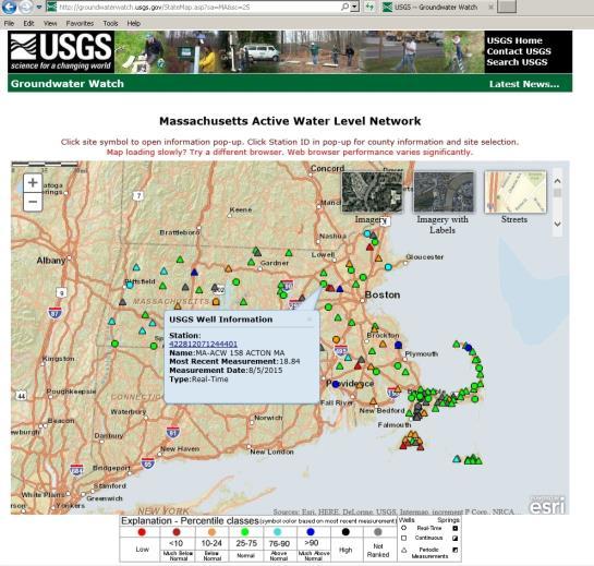
2 2. THE USE OF USGS WELLS FOR CORRELATING COMPARISONS IN WATER TABLES DURING TIMES WHEN THE WATER TABLE IS NOT AT THE ANNUAL HIGH RANGE; Current Conditions for Massachusetts: Groundwater National Water Information System: Web Interface USGS Water Resources Data Category: Geographic Area: Current Conditions Massachusetts These wells are monitored monthly Barnstable County (11 wells) MA-FSW MA-CGW 138 CHATHAM, MA MA-SDW 253 SANDWICH, MA MA-SDW (90MW0063) MA-BHW 198 BOURNE, MA MA-SDW (MW-145S) MA-SDW SANDWICH, MA MA-SDW (MW-126S) MA-BMW 22 BREWSTER, MA MA-WNW 17 WELLFLEET, MA MA-TSW 89 TRURO, MA Berkshire County (2 wells) MA-SJW 58 SHEFFIELD, MA MA-PTW 51 PITTSFIELD, MA Bristol County ( 1 well) MA-SHW 275 SEEKONK, MA Essex County (3 wells) MA-WPW 76 WENHAM, MA MA-NIW 27 NEWBURY, MA MA-HLW 23 HAVERHILL, MA Hampden County (1 well) MA-GLW 6 GRANVILLE, MA Hampshire County (1 well) MA-PDW 23 PELHAM, MA Middlesex County (4 wells) MA-WKW 2 WAYLAND, MA MA-ACW 158 ACTON, MA MA-WAW 38 WAKEFIELD, MA MA-XMW 78 WILMINGTON, MA Norfolk County (4 wells) MA-NNW 27 NORFOLK, MA MA-LKW 14 LAKEVILLE, MA MA-PWW 22 PLYMOUTH, MA MA-D4W 79 DUXBURY, MA Worcester County (2 wells) MA-WSW 26 WEST BOYLSTON, MA MA-PHW 16 PETERSHAM, MA
 12 14 16 18 20 22 USGS 2013 2014")


3 Depth to Water level (ft. below grade) USGS Green Line Historic Daily Mean Blue/red lines current date, shaded area historic range > 90 Percentile < 10 Data Point Monthly median 3. A Department-approved method for determining inland high groundwater elevation as contained in Frimpter (1981) or Frimpter and Belfit (1992).
4 FRIMPTER METHOD An estimate of the high water level at an observation well may be derived by solving the proportion in which the ratio of the potential water level rise at a test site to the potential water level rise at an observation well is equal to the ratio of the water level range at the site to the historic water level range at an observation well in a similar geohydrologic environment. These Terms S h = S c Probable range at the site From Frimpter Graphs Observation well, current depth S r x (Ow c Ow max ) Ow r Observation well maximum high GW Observation Well range the Observation Well

5

6 Water-Level Range, In Feet Water-Level Range, In Feet SANDS AND GRAVELS IN VALLEY FLATS A maximum water-level range of 4.2 feet is expected to be equaled or exceeded at about 5% of sites in sand and gravel in valley flats Percentage of sites at which water-level range is equaled or exceeded SANDS AND GRAVELS ON TERRACES A maximum water level range of 10 feet is expected to be equaled or exceeded at about 5% of sites in sand and gravel on terraces Percentage of sites at which water-level range is equaled or exceeded
 The Range of Water Table Elevation For a Site Well Will Be Based on the")
7 Water-Level Range, In Feet TILL A maximum water level range of 17 feet is expected to be equaled or exceeded at about 5% of sites in till Percentage of sites at which water-level range is equaled or exceeded RANGE OF WATER TABLE ELEVATION FOR A SITE WELL (SR) The Range of Water Table Elevation For a Site Well Will Be Based on the Hydrogeologic Setting of the Well and Will be One of Three Values For a 5% Exceedance Value Till Wells 17 Feet Sand and Gravel Wells on Terraces 10 Feet Sand and Gravel Wells in Valley Flats 4.2 Feet
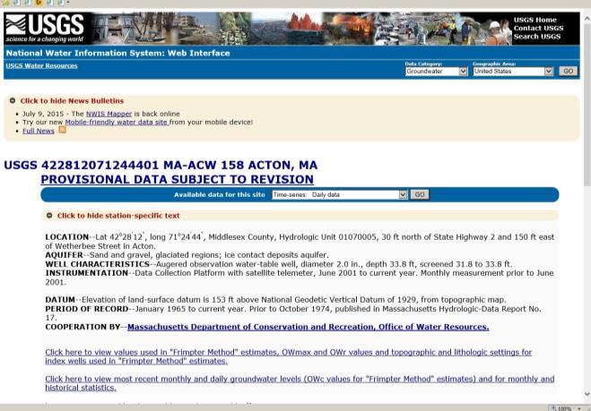
8 ACTON (ACW) 158 (real-time data since June 2001) Start year of record Land-surface elevation 153 ft, well depth 33.8 ft Lithology - SAND Topographic setting - TERRACE Period of record - HIGH (OWmax) LOW (OWr) 5.40 These Terms S h = S c 10 S r x Probable range at the site From Frimpter Graphs (April 3, 2015) (Ow c Ow max ) OW r 5.40 the Acton Well
9 Water-Level Range, In Feet ACW 158 MEAN DEPTH TO WATER DATE Jan 2015 Feb 2015 Mar 2015 Apr P P P P P P P P P P P P P P P P P P P P P P P P P P P P P P P P P P P P P P P P P P P P P P P P P P P P P P P P P P P P P P P P P COUNT MAX MIN SANDS AND GRAVELS ON TERRACES A maximum water level range of 10 feet is expected to be equaled or exceeded at about 5% of sites in sand and gravel on terraces Percentage of sites at which water-level range is equaled or exceeded These Terms S h = 10 Probable range at the site From Frimpter Tables 10 x ( ) 5.40 the Acton Well

10 These Terms S h = x the Acton Well These Terms S h = S h = 2.03
11 These Terms S h = S c Observation well, current depth S r x (Ow c Ow max ) Ow r Observation well maximum high GW Probable range at the site From Frimpter Graphs Observation Well range the Observation Well WAKEFIELD (WAW) 38 (real-time data since July 2001) Start year of record Land-surface elevation 80 ft, well depth 25.5 ft Lithology - SAND Topographic setting - FLAT Period of record - HIGH (OWmax) 2.92 LOW 9.99 (OWr) 6.33
12 Water-Level Range, In Feet WAW38 MEAN DEPTH TO WATER DATE Jan 2015 Feb 2015 Mar 2015 Apr P 6.54 P 6.99 P 5.29 P P 6.54 P 6.99 P 5.33 P P 6.59 P 7.01 P 5.28 P P 6.61 P 6.98 P 5.19 P P 6.62 P 6.96 P 5.25 P P 6.64 P 6.97 P 5.33 P P 6.65 P 6.95 P 5.38 P P 6.67 P 6.94 P 5.43 P P 6.69 P 6.90 P 5.36 P P 6.71 P 6.70 P 5.28 P P 6.72 P 6.16 P 5.34 P P 6.73 P 5.60 P 5.46 P P 6.76 P 5.74 P 5.51 P P 6.76 P 5.69 P 5.55 P P 6.77 P 5.18 P 5.61 P P 6.81 P 5.18 P 5.67 P P 6.82 P 5.18 P 5.68 P P 6.84 P 5.15 P 5.73 P P 6.85 P 5.34 P 5.79 P P 6.88 P 5.49 P 5.76 P COUNT MAX MIN SANDS AND GRAVELS IN VALLEY FLATS A maximum water-level range of 4.2 feet is expected to be equaled or exceeded at about 5% of sites in sand and gravel in valley flats Percentage of sites at which water-level range is equaled or exceeded These Terms S h = x ( ) 6.33 Probable range at the site From Frimpter Tables Water Level (April, ) the Wakefield Well
13 These Terms S h = x Probable range at the site From Frimpter Tables the Wakefield Well These Terms S h = S h = 8.12 the Wakefield Well Site Maximum Site current Probable Range Observation Observation Observation on site well current well max well range Sh = Sc - [ Sr x ( Owc - Owmax) / Owr ]
14 4. A Department-approved method for determining coastal high groundwater elevation which incorporates tidal fluctuation information into use of historical high groundwater data as contained in Frimpter and Belfit (1992) or 5. If the location of the system is affected by tidal cycle, typically within 300 feet of mean high water of the ocean, monitoring the high groundwater elevation over a tidal cycle during a full moon high tide.
Design Criteria Data
 FRESNO CA Latitude = 36.77 N WMO No. 72389 Longitude =119.7 W Elevation = 328 feet Period of Record = 1972 to 1996 Average Pressure = 29.62 inches Hg Design Criteria Data Mean Coincident (Average) Values
Design Criteria Data
 MEMPHIS TN Latitude = 35.35 N WMO No. 723345 Longitude = 89.87 W Elevation = 322 feet Period of Record = 1973 to 1996 Average Pressure = 29.68 inches Hg Design Criteria Data Mean Coincident (Average) Values
Design Criteria Data
 TUCUMCARI NM Latitude = 35.18 N WMO No. 723676 Longitude =13.6 W Elevation = 465 feet Period of Record = 1973 to 1996 Average Pressure = 25.86 inches Hg Design Criteria Data Mean Coincident (Average) Values
J^tatldhcA. (Hnmmnnw?aii1j of ilaaaarijubrtta PAUL GUZZI COMPILED IN THE OFFICE OF (TERCENTENARY EDITION) CHAPTER 54, SECTION 133 GOVERNMENT DOCUMENTS
 CHAPTER 54, SECTION 133 GOVERNMENT DOCUMENTS") Public Document No 43 C^lecLion GOVERNMENT DOCUMENTS DEPARTMENT BOSTON PUBLIC LIBRARY J^tatldhcA (Hnmmnnw?aii1j of ilaaaarijubrtta 1974 IN ACCORDANCE WITH THE PROVISIONS OF GENERAL LAWS (TERCENTENARY EDITION)
Public Document No 43 C^lecLion GOVERNMENT DOCUMENTS DEPARTMENT BOSTON PUBLIC LIBRARY J^tatldhcA (Hnmmnnw?aii1j of ilaaaarijubrtta 1974 IN ACCORDANCE WITH THE PROVISIONS OF GENERAL LAWS (TERCENTENARY EDITION)
Current DTA Caseload and Client Counts by Town and Zip -- Privacy Version
 DTA Analytics Database: Report 1d Current DTA Caseload and Client Counts by and -- Privacy Version Information as of: 10/22/2011 Barnstable BARNSTABLE 02601 2035 69.0 3175 02630 30 1.0 52 02632 374 12.7
election Statistic* Commontoeattf) of juajsgacfjusetts JOHN F. X. DAVOREN JOV DOC * a4 HL\)t Compiled in Thb Office of Public Document No. 4.
 of juajsgacfjusetts JOHN F. X. DAVOREN JOV DOC * a4 HL\)t Compiled in Thb Office of Public Document No. 4.") Public Document No. 4. election Statistic* HL\)t Commontoeattf) of juajsgacfjusetts 1972 In accordancb with the provisions of General Laws (Tercentenary Edition) Chapter 64, Suction 133 TOGETHER WITH OTHER
Public Document No. 4. election Statistic* HL\)t Commontoeattf) of juajsgacfjusetts 1972 In accordancb with the provisions of General Laws (Tercentenary Edition) Chapter 64, Suction 133 TOGETHER WITH OTHER
1. The data below gives the eye colors of 20 students in a Statistics class. Make a frequency table for the data.
 1. The data below gives the eye colors of 20 students in a Statistics class. Make a frequency table for the data. Green Blue Brown Blue Blue Brown Blue Blue Blue Green Blue Brown Blue Brown Brown Blue
Response of a Newly Created Marsh-Wetland Affected by Tidal Forcing, Upland Discharge, and Groundwater Interaction
 Response of a Newly Created Marsh-Wetland Affected by Tidal Forcing, Upland Discharge, and Groundwater Interaction Mouth of Columbia River, Cape Disappointment State Park, Washington 12 Hans R. Moritz
Healthy by Design. Planning & Development for Vibrant Communities. October 9, 2013 State House, Boston, MA. Sponsored by
 Healthy by Design Planning & Development for Vibrant Communities October 9, 2013 State House, Boston, MA Sponsored by Massachusetts Public Health Association Partners HealthCare Metropolitan Area Planning
WIND DATA REPORT. Mt. Tom
 WIND DATA REPORT Mt. Tom September 1, 2003 November 31, 2003 Prepared for Massachusetts Technology Collaborative 7 North Drive Westborough, MA 0181 by James F. Manwell Anthony F. Ellis Taylor Geer January
WIND DATA REPORT. Mt. Lincoln Pelham, MA
 WIND DATA REPORT Mt. Lincoln Pelham, MA May 2009 to April 2010 Prepared for Massachusetts Department of Energy Resources 100 Cambridge Street, Suite 1020 Boston, MA 02114 by Jonathan D. Black James F.
Shorelines Earth - Chapter 20 Stan Hatfield Southwestern Illinois College
 Shorelines Earth - Chapter 20 Stan Hatfield Southwestern Illinois College The Shoreline A Dynamic Interface The shoreline is a dynamic interface (common boundary) among air, land, and the ocean. The shoreline
ANNUAL EVALUATION OF 2016 WATER-LEVEL MONITORING DATA FROM THE CITY OF LAS CRUCES WATER SUPPLY WELLS, NEW MEXICO
 ANNUAL EVALUATION OF 216 WATER-LEVEL MONITORING DATA FROM THE CITY OF LAS CRUCES WATER SUPPLY WELLS, NEW MEXICO prepared by Steven T. Finch, Jr., CPG Annie McCoy, CPG Water Resource and Environmental Consultants
COMPARISON OF FIXED & VARIABLE RATES (25 YEARS) CHARTERED BANK ADMINISTERED INTEREST RATES - PRIME BUSINESS*
 CHARTERED BANK ADMINISTERED INTEREST RATES - PRIME BUSINESS*") COMPARISON OF FIXED & VARIABLE RATES (25 YEARS) Fixed Rates Variable Rates FIXED RATES OF THE PAST 25 YEARS AVERAGE RESIDENTIAL MORTGAGE LENDING RATE - 5 YEAR* (Per cent) Year Jan Feb Mar Apr May Jun Jul
COMPARISON OF FIXED & VARIABLE RATES (25 YEARS) Fixed Rates Variable Rates FIXED RATES OF THE PAST 25 YEARS AVERAGE RESIDENTIAL MORTGAGE LENDING RATE - 5 YEAR* (Per cent) Year Jan Feb Mar Apr May Jun Jul
Staying in Tune with South Florida s Water Cycle for Scientists, Managers, and Policy Makers in 5 Minutes per Week
 Staying in Tune with South Florida s Water Cycle for Scientists, Managers, and Policy Makers in 5 Minutes per Week Robert Sobczak (Big Cypress Nat l Pres), Todd Hopkins (FWS), Kevin Kotun (Everglades National
Massasoit Chapter. Formed in 1940 Seventy-Four Years of Chapter History. Discover--Method--Record. January 2014
 Massasoit Chapter Formed in 1940 Seventy-Four Years of Chapter History Discover--Method--Record January 2014 Meeting Notes: The January 16, 21, 2014 Meeting was Held at The Jones River Landing. January
MIAA Ice Hockey Tournament (46th. Annual) 4th. Annual Division I North. Div. 1 North First Round
 4th. Annual Division I North. Div. 1 North First Round") 4th. Annual Division I North 1 Medford (18-2-0) 0.900 2 Reading (17-1-2) 0.900 3 Arlington (17-2-1) 0.875 4 Chelmsford (16-2-2) 0.850 5 Woburn (14-2-4) 0.800 6 Belmont (14-4-1) 0.763 7 Lynn English (11-3-2)
4th. Annual Division I North 1 Medford (18-2-0) 0.900 2 Reading (17-1-2) 0.900 3 Arlington (17-2-1) 0.875 4 Chelmsford (16-2-2) 0.850 5 Woburn (14-2-4) 0.800 6 Belmont (14-4-1) 0.763 7 Lynn English (11-3-2)
MBMG Butte Mine Flooding Monthly Report BMFOU Consent Decree BU-SEH Remedial Action Monitoring Program Contract No TO-35 September 2013
 MBMG Monthly Report BMFOU Consent Decree 02-35-BU-SEH Remedial Action Monitoring Program Contract No. 400022-TO-35 September 20 The Montana Bureau of Mines and Geology (MBMG) continued to perform monitoring
ANNUAL EVALUATION OF 2017 WATER LEVEL MONITORING DATA FROM THE CITY OF LAS CRUCES WATER SUPPLY WELLS, NEW MEXICO
 ANNUAL EVALUATION OF 217 WATER LEVEL MONITORING DATA FROM THE CITY OF LAS CRUCES WATER SUPPLY WELLS, NEW MEXICO prepared by prepared for Water Resource and Environmental Consultants www.shomaker.com 55
Presented to Idaho Washington Aquifer Collaborative February 11, Spokane River Project License
 Presented to Idaho Washington Aquifer Collaborative February 11, 2014 Spokane River Project License Contact Speed Fitzhugh, Spokane River License Manager Telephone - (509) 495-4998 Email - speed.fitzhugh@avistacorp.com
WIND DATA REPORT. Bourne Water District
 WIND DATA REPORT Bourne Water District July to September 2010 Prepared for Massachusetts Clean Energy Center 55 Summer Street, 9th Floor Boston, MA 02110 by Dylan Chase James F. Manwell Utama Abdulwahid
Developing Back Bay. Pre-Handout. Scope and Background
 Developing Back Bay Pre-Handout Scope and Background This is your third project and substantially different from the first two. It is actually a large scale planning project and as such, it is open ended.
High School Dropouts Massachusetts Public Schools
 High School Dropouts 2005-06 Massachusetts Public Schools The annual high school dropout report represents a snapshot of those students who dropped out of school in any given year. The intention of this
Herring River Restoration Project Chronology of Key Events
 August 2005 Cape Cod National Seashore (CCNS) and Town of Wellfleet Board of Selectmen entered into an MOU (MOU I) to review and summarize the scientific and technical information on the Herring River
Copies: Dave Favero Deputy Cleanup Manager Michigan RACER Trust. Rhonda Klann, MDEQ Amanda Armbruster, MDEQ John McCabe, MDEQ
 MEMO To: Sue Kaelber-Matlock MDEQ-Remediation and Redevelopment Division From: Scott Clearwater Certified Project Manager Arcadis Copies: Dave Favero Deputy Cleanup Manager Michigan RACER Trust Rhonda
News Release Northeastern Regional Field Office 4050 Crums Mill Road, Suite 203 Harrisburg, PA
 United Department of Agriculture National Agricultural Statistics Service News Release Northeastern Regional Field Office 4050 Crums Mill Road, Suite 203 Harrisburg, PA 17112-2875 Results of a recent survey
Resources and Guidance for writing a River Herring Management Plan
 Resources and Guidance for writing a River Herring Management Plan In 2011 members of the River Herring Network brainstormed a list of questions that should be answered in order to develop a plan for herring
FINAL WIND DATA REPORT. Mattapoisett Mattapoisett, Massachusetts
 FINAL WIND DATA REPORT Mattapoisett Mattapoisett, Massachusetts January 19, 2006 June 29, 2007 Prepared for Massachusetts Technology Collaborative 75 North Drive Westborough, MA 01581 by William L. W.
Tuesday, January 11, :11 AM (CST)
") Tuesday, January 11, 2011 11:11 AM (CST) -Assessment of current water conditions - Precipitation Forecast - Recommendations for Drought Monitor Upper Colorado Normal Precipitation Upper Colorado River
Tuesday, January 11, 2011 11:11 AM (CST) -Assessment of current water conditions - Precipitation Forecast - Recommendations for Drought Monitor Upper Colorado Normal Precipitation Upper Colorado River
Beach Nourishment Impact on Beach Safety and Surfing in the North Reach of Brevard County, Florida
 Beach Nourishment Impact on Beach Safety and Surfing in the North Reach of Brevard County, Florida Prepared by John Hearin, Ph.D. Coastal Engineering Vice Chairman Cocoa Beach Chapter Port Canaveral Patrick
WIND DATA REPORT. Paxton, MA
 WIND DATA REPORT Paxton, MA July 1, 2011 September 30, 2011 Prepared for Massachusetts Clean Energy Center 55 Summer Street, 9th Floor Boston, MA 02110 by Eric Morgan James F. Manwell Anthony F. Ellis
Torrild - WindSIM Case study
 Torrild - WindSIM Case study Note: This study differs from the other case studies in format, while here another model; WindSIM is tested as alternative to the WAsP model. Therefore this case should be
ANNUAL EVALUATION OF 2015 WATER LEVEL MONITORING DATA FROM THE CITY OF LAS CRUCES WATER SUPPLY WELLS, NEW MEXICO
 ANNUAL EVALUATION OF 215 WATER LEVEL MONITORING DATA FROM THE CITY OF LAS CRUCES WATER SUPPLY WELLS, NEW MEXICO prepared by Steven T. Finch, Jr., CPG Annie McCoy, CPG Water Resource and Environmental Consultants
VENICE LOCAL COASTAL PROGRAM UPDATE: COASTAL HAZARDS WELCOME
 VENICE LOCAL COASTAL PROGRAM UPDATE: COASTAL HAZARDS WELCOME 1 Introducing the Team Hosted by the Department of City Planning and grant funded in part by the California Coastal Commission 2 Workshop Purpose
LONG TERM SITE WIND DATA ANNUAL REPORT. Mass Turnpike Authority Blandford, MA
 LONG TERM SITE WIND DATA ANNUAL REPORT Mass Turnpike Authority Blandford, MA July 1, 2012 June 30, 2013 Prepared for Massachusetts Clean Energy Center 55 Summer Street, 9th Floor Boston, MA 02110 by Dylan
ATLANTIC STATES MARINE FISHERIES COMMISSION. Winter Flounder Abundance and Biomass Indices from State Fishery-Independent Surveys
 ATLANTIC STATES MARINE FISHERIES COMMISSION Winter Flounder Abundance and Biomass Indices from State Fishery-Independent Surveys Technical Committee Report to the Winter Flounder Management Board February
Fleet diversity and ownership concentration. Eric Thunberg, Chad Demarest, Andrew Kitts Social Science Branch, NEFSC June 12, 2013
 Fleet diversity and ownership concentration Eric Thunberg, Chad Demarest, Andrew Kitts Social Science Branch, NEFSC June 12, 2013 An ecological approach to measuring fleet diversity: the diversity of fishing
LHA Name/Address Ch.200 Ch.705 Ch.667 Ch.167/689 MRVP AHVP
 LHA Name/Address Ch.200 Ch.705 Ch.667 Ch.167/689 MRVP AHVP Abington Housing Authority N/A 2 110 N/A N/A N/A 71 SHAW AVENUE ABINGTON 02351 781-878-5219 Acton Housing Authority N/A 39 91 12 6 20 68 WINDSOR
Lower Coquitlam River Project Water Use Plan. Temperature Monitoring Lower Coquitlam River Project Year 2 Report
 Lower Coquitlam River Project Water Use Plan Temperature Monitoring Lower Coquitlam River Project Year 2 Report COQMON#6 Temperature Monitoring Study Lower Coquitlam River Study Period: Year 2-2007 Report
Week of July 2 nd - July 6 th. The denominator is 0. Friday
 Week of July 2 nd - July 6 th The temperature is F at 7 A.M. During the next three hours, the temperature increases 1 F. What is the temperature at 10 A.M.? A quotient is undefined. What does this mean?
Ocean Energy. Haley, Shane, Alston
 Ocean Energy Haley, Shane, Alston What is Ocean Energy? The world s oceans cover nearly 70% of the world's surface The oceans are the world's largest collector of the sun s energy that is continually
Lecture Outlines PowerPoint. Chapter 15 Earth Science, 12e Tarbuck/Lutgens
 Lecture Outlines PowerPoint Chapter 15 Earth Science, 12e Tarbuck/Lutgens 2009 Pearson Prentice Hall This work is protected by United States copyright laws and is provided solely for the use of instructors
N e w E n g l a n d L u x u r y C o a s t a l R e p o r t
 2 0 1 6 N e w E n g l a n d L u x u r y C o a s t a l R e p o r t MARKET OVERVIEW The luxury, coastal New England housing market has experienced solid growth over the second quarter of 2016 and promises
Massasoit Chapter. Formed in 1940 Seventy-Three Years of Chapter History. Discover--Method--Record. October 2013
 Massasoit Chapter Formed in 1940 Seventy-Three Years of Chapter History Discover--Method--Record October 2013 Meeting Notes: Review the October 24, 2013 Meeting. November New Business: The Massasoit Chapter
COASTAL ENVIRONMENTS. 454 lecture 12
 COASTAL ENVIRONMENTS Repeated movement of sediment & water constructs a beach profile reflecting the balance between average daily or seasonal wave forces and resistance of landmass to wave action Coasts
MAR DASHBOARD MAR. Compliant % Breakdown Mar % Late % On-time MAR APR MAY JUN JUL AUG SEP OCT NOV DEC
 Positive Response Compliance 215 Compliant 215 Non-Compliant 216 Compliant 216 Non-Compliant 1% 87% 96% 86% 96% 88% 97% 89% 89% 88% 86% 92% 93% 94% 96% 94% 8% 6% 4% 2% 13% JAN 4% 14% FEB 4% 12% 3% 11%
NEVADA SLOT MACHINES: HISTORICAL HOLD PERCENTAGE VARIATIONS ANNUAL AND MONTHLY HOLD PERCENTAGES, CENTER FOR GAMING RESEARCH, NOVEMBER 2017
 NEVADA SLOT MACHINES: HISTORICAL HOLD PERCENTAGE VARIATIONS ANNUAL AND MONTHLY HOLD PERCENTAGES, 2004-2017 CENTER FOR GAMING RESEARCH, NOVEMBER 2017 Executive Summary Hold percentage the portion of money
NYS Coastal Waters. Water Resources of NYS: THE NATURE of the COASTAL ZONE. NYS Coastal Waters. NYS Coastal Atlas. Coastal Zone Management 10/10/2014
 Water Resources of NYS: THE NATURE of the COASTAL ZONE NYS Coastal Waters NYS is the only state to border the Atlantic Ocean and the Great Lakes (Lakes Erie and Ontario). Great Lakes shoreline: 577 miles
LONG TERM SITE WIND DATA ANNUAL REPORT. Paxton, MA
 LONG TERM SITE WIND DATA ANNUAL REPORT Paxton, MA July 1, 2012 June 30, 2013 Prepared for Massachusetts Clean Energy Center Summer Street, 9th Floor Boston, MA 021 by Dylan D. Chase James F. Manwell Anthony
CROSS-SHORE SEDIMENT PROCESSES
 The University of the West Indies Organization of American States PROFESSIONAL DEVELOPMENT PROGRAMME: COASTAL INFRASTRUCTURE DESIGN, CONSTRUCTION AND MAINTENANCE A COURSE IN COASTAL DEFENSE SYSTEMS I CHAPTER
Table 1. Monthly precipitation totals from the on-site rain gage and from the Dulles weather station and their differences.
 Table 1. Monthly precipitation totals from the on-site rain gage and from the Dulles weather station and their differences. Precipitation Month On-Site Rain Dulles Weather Difference Ratio 1996-97 Gage
6 th Meeting of the Scientific Committee Puerto Varas, Chile, 9-14 September SC6-Doc17 The European Union s Annual Report Wójcik I.
 6 th Meeting of the Scientific Committee Puerto Varas, Chile, 9-14 September 2018 SC6-Doc17 The European Union s Annual Report Wójcik I., Janusz J, National report of the European Union to the 2018 SPRFMO
Taranaki Tsunami Inundation Analysis. Prepared for Taranaki Civil Defence Emergency Management Group. Final Version
 Taranaki Tsunami Inundation Analysis Prepared for Taranaki Civil Defence Emergency Management Group Final Version June 2012 AM 12/07 HBRC Plan Number 4362 Asset Management Group Technical Report Prepared
Hazardous Waste Operations & Emergency Response Training
 Hazardous Waste Operations & Emergency Response Training Hazardous Waste Operations $595.00 HW 180 40 hr Initial Days 1-5 @7:30 AM - 3:30 PM May 7-11, 2018 June 11-15, 2018 July 16-20, 2018 August 13-17,
Bathymetry Data Collection for Subaqueous Soil Mapping. Maggie Payne 2 nd National Workshop on Subaqueous Soils Rhode Island August 9-12, 2010
 Bathymetry Data Collection for Subaqueous Soil Mapping Maggie Payne 2 nd National Workshop on Subaqueous Soils Rhode Island August 9-12, 2010 Overview of Method Collect tide data Collect bathymetry data
Atlantic States Marine Fisheries Commission
 Atlantic States Marine Fisheries Commission 1050 N. Highland Street Suite 200A N Arlington, VA 22201 703.842.0740 703.842.0741 (fax) www.asmfc.org MEMORANDUM TO: FROM: Atlantic Menhaden Management Board
APPENDIX F GROUNDWATER SAMPLING LOGS
 APPENDIX F GROUNDWATER SAMPLING LOGS Project:Enclave on 241 St Site Location: Bronx Well No: MW07 Date: 10/6/2015 Initial Depth to Water (ft): 15.13 Well Depth (ft): 20.00 Pump Intake Depth (ft): 19 1225
Draft Kivalina Wind Resource Report
 Draft Kivalina Wind Resource Report Kivalina aerial photo by Doug Vaught, July 2011 May 31, 2012 Douglas Vaught, P.E. dvaught@v3energy.com V3 Energy, LLC Eagle River, Alaska Draft Kivalina Wind Resource
SACO RIVER AND CAMP ELLIS BEACH SACO, MAINE SECTION 111 SHORE DAMAGE MITIGATION PROJECT APPENDIX F ECONOMIC ASSESSMENT
 SACO RIVER AND CAMP ELLIS BEACH SACO, MAINE SECTION 111 SHORE DAMAGE MITIGATION PROJECT APPENDIX F ECONOMIC ASSESSMENT Department of the Army New England District, Corps of Engineers 696 Virginia Road
2005 DIVISION 1A TOURNAMENT
 2005 DIVISION 1A TOURNAMENT /6 /10 /14 /14 /10 /6 Catholic Arlington Memorial Catholic Catholic Reading St. John's St. John's 4 Memorial Prep Prep Austin Catholic 4 /17 /17 St. John's 4 Prep Memorial Waltham
Ocean color data for Sardinella lemuru management in Bali Strait
 Ocean color data for Sardinella lemuru management in Bali Strait Jonson Lumban Gaol 1, B. P. Pasaribu 1, K. Mahapatra 2, Y. Okada and T. Osawa 3 1 Department of Marine Science and Technology Bogor Agriculture
Pitka s Point, Alaska Wind Resource Report
 Pitka s Point, Alaska Wind Resource Report Pitka s Point met tower, photo by Doug Vaught April 25, 2012 Douglas Vaught, P.E. V3 Energy, LLC Eagle River, Alaska Page 2 Summary The wind resource measured
System Flexibility Indicators
 System Flexibility Indicators Place your chosen image here. The four corners must just cover the arrow tips. For covers, the three pictures should be the same size and in a straight line. Operational Forum
Coquitlam/Buntzen Project Water Use Plan
 Coquitlam/Buntzen Project Water Use Plan Temperature Monitoring Lower Coquitlam River Project Year 3 Report Reference: COQMON#6 Study Period: March 2008 April 2009 Report Date: April 2009 Trow Associates
WIND DATA REPORT. Mt. Tom
 WIND DATA REPORT Mt. Tom June 1, 2003 August 31, 2003 Prepared for Massachusetts Technology Collaborative 7 North Drive Westborough, MA 0181 by James F. Manwell Anthony F. Ellis Taylor Geer October 30,
Investigation of the Impact of Beach Raking on Beach Accretion/Erosion: West End Beaches of Galveston Island, Texas 2007/ 2008
 Investigation of the Impact of Beach Raking on Beach Accretion/Erosion: West End Beaches of Galveston Island, Texas 2007/ 2008 By Robert Webster 1, Timothy Dellepenna Ph.D. 1, 1 Texas A&M at Galveston
Drought: What is the Status?
 Drought: What is the Status? Nolan J. Doesken Colorado Climate Center Colorado State University http://ccc.atmos.colostate.edu Presented at 2005 Peak to Prairie Landscape Symposium, February 11, 2005,
Unit 4 Lesson 3 Earth s Tides. Copyright Houghton Mifflin Harcourt Publishing Company
 Florida Benchmarks SC.8.N.1.1 Define a problem from the eighth grade curriculum using appropriate reference materials to support scientific understanding, plan and carry out scientific investigations of
Don Pool and Jeff Kennedy, USGS Brian Conway, Arizona Dept. Water Resources
 USGS Arizona Water Science Center Gravity Program Don Pool and Jeff Kennedy, USGS Brian Conway, Arizona Dept. Water Resources Black Hills Limestone Aquifer Project DUSEL project Sagehen Creek Sierra Nevada
Climatic Parameters Variability & Climate Change in Lebanon
 Expert Workshop on Developing the Capacities of the Health Sector for Climate Change Adaptation to Protect Health from the Climate Change Effects on Freshwater Resources Amman, 19-21 April 216 Climatic
Monitoring the length structure of commercial landings of albacore tuna during the fishing year
 SCTB15 Working Paper ALB-5 Monitoring the length structure of commercial landings of albacore tuna during the 2001 2002 fishing year Linda Griggs National Institute of Water and Atmospheric Research Ltd.
95 Express Annual Operations Report: Fiscal Year
 95 Express Annual Operations Report: Fiscal Year 2014-2015 General The 95 Express Program completed its sixth full Fiscal Year of operations in June 2015. For the FDOT, its Fiscal Year (FY) is from July
July Interim Report. National Institute of Wind Energy (NIWE) Wind Resource Assessment & Offshore Unit Chennai, India.
 Wind Resource Assessment & Offshore Unit Chennai, India.") Interim Report (First Offshore Lidar wind data analysis) July 2018 Prepared by National Institute of Wind Energy (NIWE) Wind Resource Assessment & Offshore Unit Chennai, India. W I N D R E S O U R C E
Interim Report (First Offshore Lidar wind data analysis) July 2018 Prepared by National Institute of Wind Energy (NIWE) Wind Resource Assessment & Offshore Unit Chennai, India. W I N D R E S O U R C E
Multi-Scaled Socio-Ecology of the Everglades FCE III Conceptual Framework
 FRESH WATER SUPPLY 1 Multi-Scaled Socio-Ecology of the Everglades FCE III Conceptual Framework Global Climate Change Regional Climate Modulation 2 B O Carbon Cycle P T Organic Matter EXTERNAL DRIVERS LOCAL
RESEARCH Massachusetts Recreational Boater Survey. Project Summary
 Coastal and Marine Spatial Planning RESEARCH Project Summary 2010 Massachusetts Recreational Boater Survey The 2010 Massachusetts Recreational Boater Survey gathered spatial and economic data relating
MIAA Ice Hockey Tournament (57th. Annual) 9th. Annual Division 1A Super 8
 9th. Annual Division 1A Super 8") 9th. Annual Division 1A Super 8 1. BC High (17-2-1).875 2. Reading (18-0-2).950 3. Archbishop Williams (14-2-3).816 4. Arlington (15-2-3).825 5. St. John s Prep (12-5-3).675 6. Catholic Memorial (11-4-3).694
9th. Annual Division 1A Super 8 1. BC High (17-2-1).875 2. Reading (18-0-2).950 3. Archbishop Williams (14-2-3).816 4. Arlington (15-2-3).825 5. St. John s Prep (12-5-3).675 6. Catholic Memorial (11-4-3).694
WIND DATA REPORT. Mt. Tom
 WIND DATA REPORT Mt. Tom March 1, 2004 May 31, 2004 Prepared for Massachusetts Technology Collaborative 75 North Drive Westborough, MA 01581 by James F. Manwell Anthony F. Ellis Ashwin Gambhir July 20,
September 2017: Aspen Snowmass Real Estate Market Snapshot RELEASED 10/08/17 ON OR NEAR THE 1ST MONDAY EACH MONTH
 September 2017: Aspen Snowmass Real Estate Market Snapshot RELEASED 10/08/17 ON OR NEAR THE 1ST MONDAY EACH MONTH v2.1 The Estin Report publishes a monthly Aspen real estate market Snapshot on or near
Figure 1, Chart showing the location of the Breach at Old Inlet and sensors deployed in Great South Bay.
 The Impact on Great South Bay of the Breach at Old Inlet Charles N. Flagg and Roger Flood School of Marine and Atmospheric Sciences, Stony Brook University The Great South Bay project (http://po.msrc.sunysb.edu/gsb/)
Managing and Adapting to Sea Level Rise in Egypt. Coastal Research Institute
 Managing and Adapting to Sea Level Rise in Egypt Coastal Research Institute Global Perspective Climate-induced increases in sea level are caused by thermal expansion of the oceans and melting of land ice
Cape Cod Water Resources Restoration Project! Presented By:! Donald Liptack! USDA/NRCS District Conservationist!
 Cape Cod Water Resources Restoration Project! Presented By:! Donald Liptack! USDA/NRCS District Conservationist! CCWRRP Locally-led Coastal Habitat Restoration to Improve Water Quality on Cape Cod" Cape
CCoWS. Central Coast Watershed Studies. Summary of Precipitation and Streamflow for Potrero and San Clemente Creeks in 2010
 Central Coast Watershed Studies CCoWS Summary of Precipitation and Streamflow for Potrero and San Clemente Creeks in Water-Year 2010 Santa Lucia Preserve Monterey County, California Publication No. WI-2011-01
Properties. terc.ucdavis.edu 8
 Physical Properties 8 Lake surface level Daily since 1900 The lowest lake level on record was 6,220.26 feet on Nov. 30, 1992. Since 1900, lake level has varied by more than 10 feet. Lake level typically
RI Regulatory Setbacks & Buffers: Coastal Management Issues
 RI Regulatory Setbacks & Buffers: Coastal Management Issues New England Onsite Wastewater Training Program @ URI OWT 155 - November 29, 2012 James Boyd - Coastal Policy Analyst Photo: October 30, 2012
CT EXPANSION PROJECT SILT FENCE DESIGN CRITERIA AND METHODOLOGY CONNECTICUT LOOP. Submitted by:..
 CT EXPANSION PROJECT SILT FENCE DESIGN CRITERIA AND METHODOLOGY CONNECTICUT LOOP Submitted by:.. Tennessee Gas Company L.L.C. 1001 Louisiana St, Suite 1000 Houston, TX 77002 July 2014 Revised March 2015
LAB H - ATMOSPHERE AND CLIMATE LAB II STABILITY AND PRECIPITATION PATTERNS
 Introduction LAB H - ATMOSPHERE AND CLIMATE LAB II STABILITY AND PRECIPITATION PATTERNS This lab will provide students with the opportunity to become familiar with the concepts of atmospheric stability
A high-resolution cellulose δ 18 O record of Pinus merkusii from Cambodia and its climate implications
 A high-resolution cellulose δ 18 O record of Pinus merkusii from Cambodia and its climate implications Mengfan Zhu, Lowell Stott University of Southern California Brendan Buckley LDEO, Columbia University
Site Description: Tower Site
 Wind Resource Summary for Elizabeth Site Final Report Colorado Anemometer Loan Program Monitoring Period: 7/3/6 /15/7 Report Date: December 22, 7 Site Description: The site is.6 miles northeast of the
WIND DATA REPORT. Bishop and Clerks
 WIND DATA REPORT Bishop and Clerks March 1, 2004 May 31, 2004 Prepared for Massachusetts Technology Collaborative 75 North Drive Westborough, MA 01581 by James F. Manwell Anthony L. Rogers Anthony F. Ellis
Current Status and Future. Hudson River American shad stock. New York State Dept. of Environmental Conservation
 Current Status and Future of the Hudson River American shad stock K. Hattala and A. Kahnle New York State Dept. of Environmental Conservation September 2009 Life history Young-of-year and dimmature fish
WIND DATA REPORT. Mass Turnpike Authority Blandford, MA
 WIND DATA REPORT Mass Turnpike Authority Blandford, MA April 2012 June 2012 Prepared for Massachusetts Clean Energy Center 55 Summer Street, 9th Floor Boston, MA 02110 by Preeti Verma James F. Manwell
Maturity and Spawning of the Small Yellow Croaker, Larimichthys polyactis
 Maturity and Spawning of the Small Yellow Croaker, Larimichthys polyactis Hyunjung Kang Kang 1, Yeonghye Kim 1, Jinkoo Kim 2, Sungyeon Kim 1, Sukgeun Jung 1, Dongwoo Lee 1 National Fisheries Research Development
Community Water Systems and Chapter 587
 Community Water Systems and Chapter 587 Managing the Protection of In-Stream Flows, Lake and Pond Water Levels Andrews L. Tolman and Michael D. Abbott Hydrogeologists for the Maine CDC Drinking Water Program
Chart Discussion: Fri-25-May-2018 Rainfall Last Week
 Chart Discussion: Fri-25-May-2018 Rainfall Last Week 1 Last Week s Charts 2 MSL Analysis / Sat Image (Thu) 3 MSL Analysis / Sat Image (Fri) 4 Last Week s Model Forecasts OBSERVED Chart Discussion: Fri-25-May-2018
Waters rise and fall in tides.
 Page 1 of 5 KEY ONEPT Waters rise and fall in tides. BEFORE, you learned Wind provides the energy to form waves in the ocean Ocean waves change near shore The ocean is a global body of water NOW, you will
MILE POINT TRAINING WALL JACKSONVILLE, FL. Geotextile Tube Installation
 MILE POINT TRAINING WALL JACKSONVILLE, FL Geotextile Tube Installation PROJECT DESIGN Remove portion of existing training wall Construct new eastern and western training walls Deepen new flow improvement
TIDAL ANALYSIS AT KUALA LANGSA AND PUSONG ISLAND USING ADMIRALTY METHOD
 TIDAL ANALYSIS AT KUALA LANGSA AND PUSONG ISLAND USING ADMIRALTY METHOD ANNISA SRI SUGIARTI 1 *, MARWAN 2, ICHSAN SETIAWAN 3 1 Graduate Program of Disaster Science,Syiah Kuala University, Darussalam, *Email:
Colorado River Drought Response and System Sustainability. Chuck Cullom July 16, 2014
 Colorado River Drought Response and System Sustainability Chuck Cullom July 16, 2014 Study Structure and Schedule Summary of Key Activities Upcoming Meetings Further Discussion, Follow-up Colorado River
Ocean Wave Forecasting at ECMWF
 Ocean Wave Forecasting at ECMWF Jean-Raymond Bidlot Marine Aspects Section Predictability Division of the Research Department European Centre for Medium-range Weather Forecasts (E.C.M.W.F.) Reading, UK
GONE! Coastal Erosion Happens During Storms! Why Worry About Coastal Setbacks? Goals for Today
 RI Regulatory Setbacks & Buffers: Coastal Zone Management Issues New England Onsite Wastewater Training Program @ URI OWT 155 November 21, 2013 Goals for Today Understand the impacts of storms, coastal