Don Pool and Jeff Kennedy, USGS Brian Conway, Arizona Dept. Water Resources
|
|
|
- Clarence Hart
- 5 years ago
- Views:
Transcription

1 USGS Arizona Water Science Center Gravity Program Don Pool and Jeff Kennedy, USGS Brian Conway, Arizona Dept. Water Resources
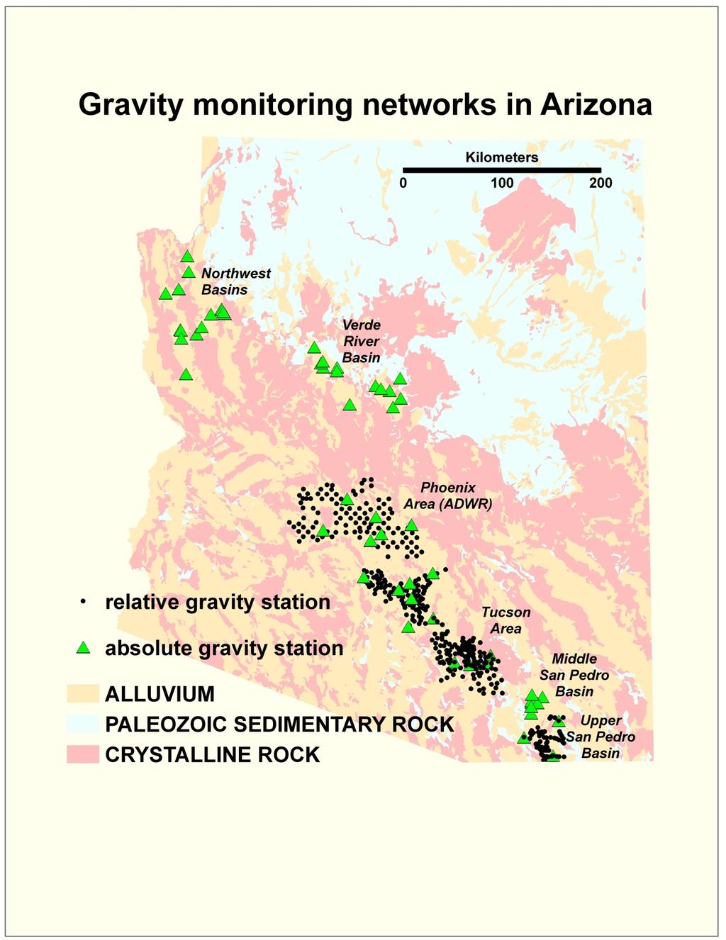
2

3 Black Hills Limestone Aquifer Project DUSEL project

4 Sagehen Creek Sierra Nevada
5
6

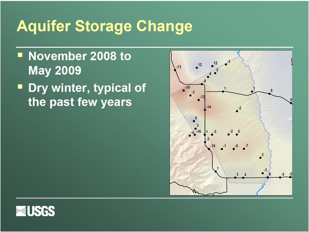
7 ADWR PINAL AMA
8 Tucson basin storage change
9

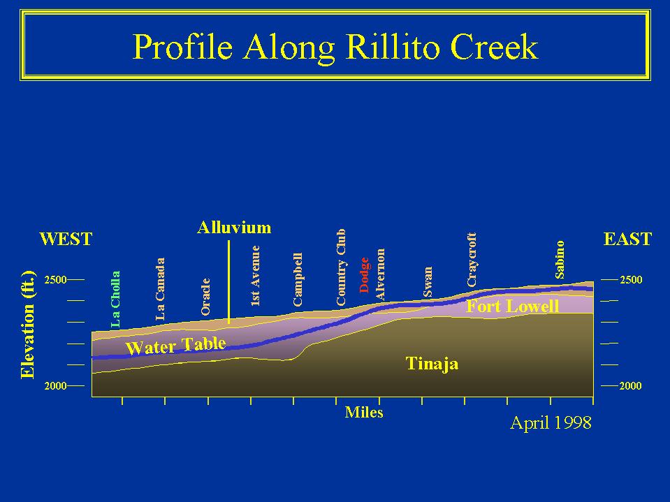
10 Rillito Creek Ephemeral Channel Recharge AND GRAVITY AT WELL A-54 DEPTH TO WATER, FT Jul-97 GRAVITY CHANGE, MILLIGAL WL GRAVITY BASIN TIES Jan-98 Jul-98 Jan-99 Jul-99 Jan-00 Jul Jan-01 First Ave Profile A B-92 WL AND GRAVITY AT WELL B-92 GRAVITY 330 DEPTH TO WATER, FT Jul Jan-98 Jul-98 Jan-99 Jul-99 Jan-00 Jul Jan-01 GRAVITY CHANGE, MILLIGAL USGS
11 AND GRAVITY AT WELL A DEPTH TO WATER, FT Jul-97 GRAVITY CHANGE, MILLIGAL WL GRAVITY BASIN TIES Jan-98 Jul-98 Jan-99 Jul-99 Jan-00 Jul Jan-01 WL AND GRAVITY AT WELL B-92 GRAVITY 330 DEPTH TO WATER, FT Jul Jan-98 Jul-98 Jan-99 Jul-99 Jan-00 Jul Jan-01 GRAVITY CHANGE, MILLIGAL
12 Gravity Change along First Avenue, Since Dec. 97 4/21/ /6/98 Floodplain South North Gravity Change, Milligal Storage Gain Storage Loss Rillito Creek Distance, Miles
13 Gravity Change along First Avenue, Since Dec. 97 4/21/ Floodplain South North Gravity Change, Milligal Storage Gain Storage Loss Rillito Creek Distance, Miles
14 Gravity Change along First Avenue, Since Dec. 97 4/21/ /6/98 10/23/98 Floodplain South North Gravity Change, Milligal Storage Gain Storage Loss Rillito Creek Distance, Miles
15 Gravity Change along First Avenue, Since Dec. 97 4/21/ /6/98 10/23/98 6/25/99 Floodplain South North Gravity Change, Milligal Storage Gain Storage Loss Rillito Creek Distance, Miles
16 Gravity Change along First Avenue, Since Dec. 97 4/21/ /6/98 10/23/98 6/25/99 8/18/99 Floodplain South North Gravity Change, Milligal Storage Gain Storage Loss Rillito Creek Distance, Miles
17 Gravity Change along First Avenue, Since Dec. 97 4/21/ /6/98 10/23/98 6/25/99 8/18/99 1/21/00 Floodplain South North Gravity Change, Milligal Storage Gain Storage Loss Rillito Creek Distance, Miles
18 Gravity Change along First Avenue, Since Dec. 97 4/21/ /6/98 10/23/98 6/25/99 8/18/99 1/21/00 Floodplain South 6/2/00 North Gravity Change, Milligal Storage Gain Storage Loss Rillito Creek Distance, Miles
19 Gravity Change along First Avenue, Since Dec. 97 4/21/ /6/98 10/23/98 6/25/99 8/18/99 1/21/00 6/2/00 Floodplain South 03/02/02 North Gravity Change, Milligal Storage Gain Storage Loss Rillito Creek Distance, Miles
20 E:\Shared\gmsys\1ST21098 Gravity (mgals) 0.06 Generated with GM-SYS Fri Apr 25 17:04: =Observed, =Calculated B92 Air D=0 WR A1B B91 A18 Depth (km) A STORAGE LOSS D= V.E.=30 Scale= Distance (km) 9.6
21 E:\Shared\gmsys\1ST31298 Gravity (mgals) 0.06 Generated with GM-SYS Fri Apr 25 17:32: =Observed, =Calculated B92 Air D=0 WR A1B B91 A18 Depth (km) A STORAGE LOSS D= V.E.=30 Scale= Distance (km) 9.6
22 E:\Shared\gmsys\1ST42198 Gravity (mgals) 0.06 Generated with GM-SYS Fri Apr 25 17:40: =Observed, =Calculated B92 Air D=0 WR A1B B91 A18 Depth (km) A STORAGE LOSS D= V.E.=30 Scale= Distance (km) 9.6
23 E:\Shared\gmsys\1ST53098 Gravity (mgals) 0.06 Generated with GM-SYS Sat Apr 26 11:29: =Observed, =Calculated B92 Air D=0 WR A1B B91 A18 Depth (km) A STORAGE LOSS D= V.E.=30 Scale= Distance (km) 9.6
24 E:\Shared\gmsys\1ST Gravity (mgals) 0.06 Generated with GM-SYS Fri Apr 25 18:10: =Observed, =Calculated B92 Air D=0 WR A1B B91 A18 Depth (km) A STORAGE LOSS D= V.E.=30 Scale= Distance (km) 9.6
25 E:\Shared\gmsys\1ST Gravity (mgals) 0.06 Generated with GM-SYS Fri Apr 25 18:16: =Observed, =Calculated B92 Air D=0 WR A1B B91 A18 Depth (km) A STORAGE LOSS D= V.E.=30 Scale= Distance (km) 9.6
26 E:\Shared\gmsys\1ST Gravity (mgals) 0.06 Generated with GM-SYS Fri Apr 25 18:21: =Observed, =Calculated B92 Air D=0 WR A1B B91 A18 Depth (km) A STORAGE LOSS D= V.E.=30 Scale= Distance (km) 9.6
27 E:\Shared\gmsys\1ST Gravity (mgals) 0.06 Generated with GM-SYS Fri Apr 25 18:31: =Observed, =Calculated B92 Air D=0 WR A1B B91 A18 Depth (km) A STORAGE LOSS D= V.E.=30 Scale= Distance (km) 9.6
28 E:\Shared\gmsys\1ST Gravity (mgals) 0.06 Generated with GM-SYS Fri Apr 25 18:39: =Observed, =Calculated B92 Air D=0 WR A1B B91 A18 Depth (km) A STORAGE LOSS D= V.E.=30 Scale= Distance (km) 9.6
29 E:\Shared\gmsys\1ST Gravity (mgals) 0.06 Generated with GM-SYS Sat Apr 26 11:41: =Observed, =Calculated B92 Air D=0 PIMA WASH LEVEL WR ALLUV BASE IN WASH A1B B91 A18 Depth (km) A54 North First Copy of Air D BBB2 D=0 ALLUV BASE first break TERRACE G Stream shallow alluvium well wl stream alluvium TERRACE GRAVEL CONLG TOP Partial y SATURATEDRED CLAY&GRAV TOP D=0.07 Base deep well sandywlzone Fl WL BR CLAY WL WL WL BH D=-0.2 UNSATURATED FL BASE D=0-0.6 second break Tinaja? 1.6 V.E.=30 Scale=72683 STORAGE LOSS BH WL RED CONGL TOP CONGL V. HARD RED SHALE TOP BH BOTTOM CASING 5.6 Distance (km) 9.6
30 E:\Shared\gmsys\1ST Gravity (mgals) 0.06 Generated with GM-SYS Fri Apr 25 18:55: =Observed, =Calculated B92 Air D=0 WR A1B B91 A18 A54 Depth (km) Ril ito wl STORAGE LOSS D= V.E.=30 Scale= Distance (km) 9.6
31 E:\Shared\gmsys\1ST Gravity (mgals) 0.06 Generated with GM-SYS Sat Apr 26 11:24: =Observed, =Calculated B92 Air D=0 WR A1B B91 A18 A54 Depth (km) Ril ito wl STORAGE LOSS D= V.E.=30 Scale= Distance (km) 9.6

32 Absolute Gravity Observations USGS Office

33 New Withdrawal Well Near USGS Office


34 SG Meter Gravity Record USGS Office
35 Spatial and temporal distributions of gravity change Largest changes (>40 microgal) Rapid change in areas with large periodic input Drainage over weeks to months Near ephemeral stream channels, large depth to water Porous rocks in high elevations Long-term trends Groundwater mining Change from GW to SW irrigation Smaller changes across broad areas of alluvial basins locally in areas of low porosity rocks
LIFE HISTORY DIVERSITY AND RESILIENCE
 LIFE HISTORY DIVERSITY AND RESILIENCE SPRING CHINOOK IN THE WILLAMETTE RIVER BASIN Kirk Schroeder Brian Cannon Luke Whitman Paul Olmsted Oregon Department of Fish and Wildlife Corvallis Research Lab Thanks
MBMG Butte Mine Flooding Monthly Report BMFOU Consent Decree BU-SEH Remedial Action Monitoring Program Contract No TO-35 September 2013
 MBMG Monthly Report BMFOU Consent Decree 02-35-BU-SEH Remedial Action Monitoring Program Contract No. 400022-TO-35 September 20 The Montana Bureau of Mines and Geology (MBMG) continued to perform monitoring
Proposed Reclassification of Muskrat Creek, North Platte River Basin in Goshen County, Wyoming
 Proposed Reclassification of Muskrat Creek, North Platte River Basin in Goshen County, Wyoming October 25, 2010 Waterbody: Muskrat Creek - Mainstem of Muskrat Creek from its headwaters downstream to its
Properties. terc.ucdavis.edu 8
 Physical Properties 8 Lake surface level Daily since 1900 The lowest lake level on record was 6,220.26 feet on Nov. 30, 1992. Since 1900, lake level has varied by more than 10 feet. Lake level typically
Climate Change and Hydrology in the Sierra Nevada. Lorrie Flint U.S. Geological Survey Sacramento CA
 Climate Change and Hydrology in the Sierra Nevada Lorrie Flint U.S. Geological Survey Sacramento CA Discussion Topics Climate change for California Methods to evaluate hydrologic impacts Water balance
Community Water Systems and Chapter 587
 Community Water Systems and Chapter 587 Managing the Protection of In-Stream Flows, Lake and Pond Water Levels Andrews L. Tolman and Michael D. Abbott Hydrogeologists for the Maine CDC Drinking Water Program
Water industry perspective on the main groundwater management challenges. Luke de Vial Head of Water Resources and Supply
 Water industry perspective on the main groundwater management challenges Luke de Vial Head of Water Resources and Supply 2 Key 3 Natural History Museum Key Sources at risk from exceeding nitrate limits
STUDY PERFORMANCE REPORT
 STUDY PERFORMANCE REPORT State: Michigan Project No.: F-80-R-4 Study No.: 702 Title: Effects of sediment traps on Michigan river channels Period Covered: October 1, 2002 to September 30, 2003 Study Objectives:
Response of a Newly Created Marsh-Wetland Affected by Tidal Forcing, Upland Discharge, and Groundwater Interaction
 Response of a Newly Created Marsh-Wetland Affected by Tidal Forcing, Upland Discharge, and Groundwater Interaction Mouth of Columbia River, Cape Disappointment State Park, Washington 12 Hans R. Moritz
Colorado River Drought Response and System Sustainability. Chuck Cullom July 16, 2014
 Colorado River Drought Response and System Sustainability Chuck Cullom July 16, 2014 Study Structure and Schedule Summary of Key Activities Upcoming Meetings Further Discussion, Follow-up Colorado River
San Antonio Creek Spreading Grounds Rehabilitation Project Ojai Valley, CA
 Ventura County Watershed Protection District San Antonio Creek Spreading Grounds Rehabilitation Project Ojai Valley, CA Presentation to Ventura River Watershed Council Project Funding Proposition 50 Integrated
Annex P Water Well Modification Plan
 Annex P Water Well Modification Plan Table P1 Table P2 Summary of data Concerning Wells Sampled Summary of New Pump Characteristics H:\WP\1346\Appendices\FEIS\D - Drawdown\CamRdy\App_D.doc Annex P: Water
Presented to Idaho Washington Aquifer Collaborative February 11, Spokane River Project License
 Presented to Idaho Washington Aquifer Collaborative February 11, 2014 Spokane River Project License Contact Speed Fitzhugh, Spokane River License Manager Telephone - (509) 495-4998 Email - speed.fitzhugh@avistacorp.com
Executive Summary Mount Milligan 2004
 Executive Mount Milligan 2004 Mt. Milligan Lake is a shallow and productive, 24 ha, marl bottomed lake situated 110 km southwest of Mackenzie. A stocking assessment was conducted at Mt. Milligan Lake between
ESA, Proposed Threatened ESA, Threatened New Mexico-WCA, Endangered
 Scientific Name: Catostomus insignis Common Name: Sonora sucker BISON No.: 010520 Legal Status: Arizona, Species of Special Concern ESA, Endangered ESA, Proposed Endangered ESA, Proposed Threatened ESA,
Trip Report: Eagle Creek, Arizona
 Trip Report: Eagle Creek, Arizona 15-17 June 2009 Participants: Abraham Karam, Brian Kesner, and Mike Childs Native Fish Lab Marsh & Associates, LLC 5016 South Ash Avenue Suite 108 Tempe, Arizona 85282
PROFILE OF SACRAMENTO RIVER, FREEPORT TO VERONA, CALIFORNIA,
 PROFILE OF SACRAMENTO RIVER, FREEPORT TO VERONA, CALIFORNIA, FLOOD OF FEBRUARY 1986 By J.C. Blodgett and J.B. Lucas U.S. GEOLOGICAL SURVEY Open-File Report 88-82 CO CM I m r-h CM Sacramento, California
CLEVELAND UTILITIES WATER DIVISION WATER & WASTEWATER RATES Effective July 1, 2018 (Minimum bills will apply based on meter size.)
") CLEVELAND UTILITIES WATER DIVISION WATER & WASTEWATER RATES Effective July 1, 2018 ( bills will apply based on meter size.) WATER RATE INSIDE CITY OUTSIDE CITY RESIDENTIAL (Class 201, 202) Customer Charge
CLEVELAND UTILITIES WATER DIVISION WATER & WASTEWATER RATES Effective July 1, 2018 ( bills will apply based on meter size.) WATER RATE INSIDE CITY OUTSIDE CITY RESIDENTIAL (Class 201, 202) Customer Charge
Geography of the Lower Fitzroy and navigation problems
 Geography of the Lower Fitzroy and navigation problems A topographic map of the Fitzroy estuary readily indicates why the Fitzroy River has proved difficult for shipping to negotiate. The river meanders
I 595 Express Corridor Improvements Project. February 2014 Update
 I 595 Express Corridor Improvements Project February 2014 Update PROJECT COMPONENTS Reversible Express Lanes Direct Connect to Florida s Turnpike Open Road Tolling SR 84 Continuous Connection Florida s
Stephens Creek Culvert Replacement. CAC April 28, 2010
 Stephens Creek Culvert Replacement CAC April 28, 2010 1 Top of Bank Willamette Moorage Park Existing Culverts 50 ft Greenway Setback 200 ft Greenway Setback Existing Macadam Bay Access Stephens Creek Existing
Gas Clogging During Spreading Basin Recharge
 POWERPOINT PRESENTATION Gas Clogging During Spreading Basin Recharge Victor Heilweil, Ph.D. Research Hydrologist U.S. Geological Survey West Valley City, Utah Managed Aquifer Recharge Symposium January
HOW TO MAKE MORE PRODUCTION WITH PLUNGER LIFT
 HOW TO MAKE MORE PRODUCTION WITH PLUNGER LIFT D E V E L O P I N G UNCONVENTIONAL G A S T E C H N I C A L W O R K S H O P M AR C H 2 9, 2 0 1 0 CONTENTS PLUNGER LIFT BENEFITS WITH TELEMETRY HOW TO OPTIMIZE
Climate Change Adaptation and Stream Restoration. Jack Williams;
 Climate Change Adaptation and Stream Restoration Jack Williams; jwilliams@tu.org 1 Goals for this presentation Develop strategies for adapting streams to climate impacts by Thinking like a watershed Understanding
Tuesday, January 11, :11 AM (CST)
") Tuesday, January 11, 2011 11:11 AM (CST) -Assessment of current water conditions - Precipitation Forecast - Recommendations for Drought Monitor Upper Colorado Normal Precipitation Upper Colorado River
Tuesday, January 11, 2011 11:11 AM (CST) -Assessment of current water conditions - Precipitation Forecast - Recommendations for Drought Monitor Upper Colorado Normal Precipitation Upper Colorado River
Culvert Design for Low and High Gradient Streams in the Midwest. Dale Higgins, Hydrologist Chequamegon-Nicolet National Forest
 Culvert Design for Low and High Gradient Streams in the Midwest Dale Higgins, Hydrologist Chequamegon-Nicolet National Forest Overview Culvert Design Considerations Hydraulic Terms Culvert Impacts Low
ANNUAL EVALUATION OF 2016 WATER-LEVEL MONITORING DATA FROM THE CITY OF LAS CRUCES WATER SUPPLY WELLS, NEW MEXICO
 ANNUAL EVALUATION OF 216 WATER-LEVEL MONITORING DATA FROM THE CITY OF LAS CRUCES WATER SUPPLY WELLS, NEW MEXICO prepared by Steven T. Finch, Jr., CPG Annie McCoy, CPG Water Resource and Environmental Consultants
STREAM SURVEY File form No..
 scanned for KRIS THE RESOURCES AGENCY OF CALIFORNIA California Department of Fish and Game STREAM SURVEY File form No.. Date: September 4, 1969. NAME: North Fork Schooner Gulch Creek COUNTY: Mendocino.
Little Spokane River Stream Gage Report: Deadman Creek, Dragoon Creek, and the West Branch of the Little Spokane River
 Little Spokane River Stream Gage Report: Deadman Creek, Dragoon Creek, and the West Branch of the Little Spokane River June 2010 Spokane County Conservation District N. 210 Havana St. Spokane, WA 99202
Proposed Reclassification of Cherry Creek, North Platte River Basin, Wyoming. October 25, 2010
 Proposed Reclassification of Cherry Creek, North Platte River Basin, Wyoming October 25, 2010 Waterbody: Location: Tributary to: Cherry Creek - Mainstem from headwaters downstream to the confluence with
Oxbows and Sloughs: Wisconsin s Forgotten Lakes
 University of Massachusetts - Amherst ScholarWorks@UMass Amherst International Conference on Engineering and Ecohydrology for Fish Passage International Conference on Engineering and Ecohydrology for Fish
Well PGE-6 Decommissioning Evaluation PG&E Topock Compressor Station
 TECHNICAL MEMORANDUM Well PGE-6 Decommissioning Evaluation PG&E Topock Compressor Station DATE: February 28, 2006 Introduction This technical memorandum presents an evaluation of inactive water supply
GEOS 5311 Lecture Notes: Numerical Modeling Example, Yucca Mountain, Nevada
 GEOS 5311 Lecture Notes: Numerical Modeling Example, Yucca Mountain, Nevada Dr. T. Brikowski Spring 2010 file:yuccamtn.tex,v (1.11, January 26, 2010), printed March 30, 2011 Introduction 1 Introduction:
Pore-Air Entrapment during Infiltration
 Pore-Air Entrapment during Infiltration GEO-SLOPE International Ltd. www.geo-slope.com 1200, 700-6th Ave SW, Calgary, AB, Canada T2P 0T8 Main: +1 403 269 2002 Fax: +1 888 463 2239 Introduction Infiltration
Reliable, accurate groundwater Diver dataloggers and software. Diver-Suite
 Reliable, accurate groundwater Diver dataloggers and software Diver-Suite SMART MONITORING TECHNOLOGY Diver-Suite*, from Schlumberger Water Services, provides groundwater and environmental professionals
ANALYSIS OF SKEENA RIVER TRIBUTARIES DOWNSTREAM FROM THE PROPOSED ENBRIDGE PIPELINE. December 20,
 ANALYSIS OF SKEENA RIVER TRIBUTARIES DOWNSTREAM FROM THE PROPOSED ENBRIDGE PIPELINE December 20, 2011 By Jack A. Stanford 1, and Diane C. Whited 1 1 Flathead Lake Biological Station, The University of
ANNUAL EVALUATION OF 2017 WATER LEVEL MONITORING DATA FROM THE CITY OF LAS CRUCES WATER SUPPLY WELLS, NEW MEXICO
 ANNUAL EVALUATION OF 217 WATER LEVEL MONITORING DATA FROM THE CITY OF LAS CRUCES WATER SUPPLY WELLS, NEW MEXICO prepared by prepared for Water Resource and Environmental Consultants www.shomaker.com 55
Minnesota Department of Natural Resources Division of Fish and Wildlife Section of Fisheries. Stream Survey Report. Cold Spring Creek.
 Minnesota F-29-R(P)-24 Area 315 Study 3 March 2015 Minnesota Department of Natural Resources Division of Fish and Wildlife Section of Fisheries Stream Survey Report Cold Spring Creek 2014 Mark Pelham Montrose
GROUNDWATER CONDITIONS IN THE COASTAL REGIONS OF THE DRY ZONE OF SRI LANKA. A.P.G.R.L. Perera C.R. Panabokke
 GROUNDWATER CONDITIONS IN THE COASTAL REGIONS OF THE DRY ZONE OF SRI LANKA A.P.G.R.L. Perera C.R. Panabokke Shallow Karstic Aquifer Deep Confined Aquifer Shallow Aquifers on Coastal Sands Alluvial Aquifer
Stream Assessment. Date. Data Collected by. Location. Name of Stream and River Basin. Stream Order. Streambank Materials. Streambank Vegetation
 Stream Assessment Date Data Collected by Location Name of Stream and River Basin Stream Order Streambank Materials Streambank Vegetation Floodplain Soils Floodplain Vegetation Valley Type Valley Constraints
TROUT CREEK WATERSHED (Second Year of Snowline Data)
") Extent of Snow Cover During the 2002 Spring Freshet For the TROUT CREEK WATERSHED (Second Year of Snowline Data) (Penticton Forest District) 1.0 INTRODUCTION The extent of snow cover over a watershed basin
Extent of Snow Cover During the 2002 Spring Freshet For the TROUT CREEK WATERSHED (Second Year of Snowline Data) (Penticton Forest District) 1.0 INTRODUCTION The extent of snow cover over a watershed basin
Proposed Reclassification of Horse Creek, North Platte River Basin in Goshen County, Wyoming
 Proposed Reclassification of Horse Creek, North Platte River Basin in Goshen County, Wyoming October 25, 2010 Waterbody: Location: Tributary to: Horse Creek - Mainstem from the confluence with Stinking
Temporal Variability of Soil Gas Concentrations and Pressure Under Natural Weather Conditions at Petroleum Hydrocarbon Impacted Sites
 Temporal Variability of Soil Gas Concentrations and Pressure Under Natural Weather Conditions at Petroleum Hydrocarbon Impacted Sites Emma Hong Luo, Ph.D. Chevron Energy Technology Company Houston, TX
The River Murray System
 The River Murray System Presentation to Engineers Australia Southern Highlands & Tablelands Regional Group 28 April 2011 by Tony Morse (General Manager Assets, MDBA) The Murray-Darling Basin Distribution
Gerald H. Grondin Oregon Water Resources Department Groundwater Hydrology Section Salem, Oregon. Lost River Groundwater Surface Water Management
 Geologic Framework Influence On Managing Groundwater Interference With Surface Water, A Lost River Sub-Basin Example, Upper Klamath River Basin, Oregon Gerald H. Grondin Oregon Water Resources Department
PROJECTS STREETS
 2009 Actual 2009 2010 Actual 2010 2011 Actual 2011 2012 Actual 2012 2013 Actual 2013 11,320 11,774 275 162 3,077 1,200 2,987 1,377 875 1,545 350 2,652 8,781 7,890 2,564 2,275 Pool 884 493 1,844 589 240
COMPARISON OF FIXED & VARIABLE RATES (25 YEARS) CHARTERED BANK ADMINISTERED INTEREST RATES - PRIME BUSINESS*
 CHARTERED BANK ADMINISTERED INTEREST RATES - PRIME BUSINESS*") COMPARISON OF FIXED & VARIABLE RATES (25 YEARS) Fixed Rates Variable Rates FIXED RATES OF THE PAST 25 YEARS AVERAGE RESIDENTIAL MORTGAGE LENDING RATE - 5 YEAR* (Per cent) Year Jan Feb Mar Apr May Jun Jul
COMPARISON OF FIXED & VARIABLE RATES (25 YEARS) Fixed Rates Variable Rates FIXED RATES OF THE PAST 25 YEARS AVERAGE RESIDENTIAL MORTGAGE LENDING RATE - 5 YEAR* (Per cent) Year Jan Feb Mar Apr May Jun Jul
SR 826/PALMETTO EXPRESSWAY EXPRESS LANES PD&E STUDY From US 1/SR 5/Dixie Highway to SR 836/Dolphin Expressway FPID No.: ETDM No.
 SR 826/PALMETTO EXPRESSWAY EXPRESS LANES PD&E STUDY From US 1/SR 5/Dixie Highway to SR 836/Dolphin Expressway FPID No.: 432639-1-22-02 ETDM No.: 14308 Newsletter 3 - March 2019 Incluye versión en español
TRAINING LOG BOOK NAME:
 TRAINING LOG BOOK NAME: 1 Personal Details: Name Address Home Phone No Mobile Phone No Emergency Contact Details Medical Information (Allergies, Medications ) Date of Birth Hobbies, Other Sports Height
SECTION II CORRECTIONS TO C. G. LIGHT LIST, VOLUME I ATLANTIC COAST, (5) Height. (4) Characteristic LIDO BEACH LIGHT Remove from list.
 Height. (4) Characteristic LIDO BEACH LIGHT Remove from list.") CORRECTIONS TO C. G. LIGHT LIST, VOLUME I ATLANTIC COAST, 2012 227 WHOI Temporary Research Lighted Buoy ESPI 10955 SHIPYARD QUARTERS MARINA LIGHT 27340 EAST RIVER DEEPWATER 27345 EAST RIVER DEEPWATER 145
CORRECTIONS TO C. G. LIGHT LIST, VOLUME I ATLANTIC COAST, 2012 227 WHOI Temporary Research Lighted Buoy ESPI 10955 SHIPYARD QUARTERS MARINA LIGHT 27340 EAST RIVER DEEPWATER 27345 EAST RIVER DEEPWATER 145
SWI NAPL Recovery. Cemcor Environmental Services. represented by. Contact: Craig Marlow Phone Cell
 SWI NAPL Recovery represented by Cemcor Environmental Services Contact: Craig Marlow Phone 419.867.8966 Cell 419.349.7970 Email cemarlow@att.net Physical mechanisms of SWI Injection in the saturated zone
Hydraulic Modeling of Stream Enhancement Methods
 Hydraulic Modeling of Stream Enhancement Methods Matthew J. Curry John J. Levitsky Abstract Development within watersheds increases the amounts of runoff causing stream erosion and degradation of stream
Yakima Basin Integrated Plan AWRA Summer Specialty Conference 2017 June 27, 2017 Tysons Corner, VA
 Yakima Basin Integrated Plan AWRA Summer Specialty Conference 2017 June 27, 2017 Tysons Corner, VA EA Engineering, Science, and Technology, Inc., PBC Yakima Basin Overview Basin size: 6,155 sq. miles Population:
The Calawah River System
 The Calawah River System The Calawah River is the largest tributary of the Bogachiel River and is formed by the confluence of the north and south forks of the Calawah. The two forks of the Calawah, CALAWAH
Marathon walk's Complete Performance Training Plan
 Marathon walk's Complete Performance Training Plan Distance Avg s: How did you feel, where did you go, what was the 1 10/11/15 17 weeks Build Goal - Phase 1 - Prepare to start training Strength and mobility
System Flexibility Indicators
 System Flexibility Indicators Place your chosen image here. The four corners must just cover the arrow tips. For covers, the three pictures should be the same size and in a straight line. Operational Forum
Fossil Creek Native Fish Repatriation 2009 Implementation Plan Arizona Game and Fish Department
 Fossil Creek Native Fish Repatriation 2009 Implementation Plan Arizona Game and Fish Department MONITORING: Annual monitoring is conducted for each species stocked, typically during late summer or early
ECRR and ARRN Technical Exchange Meeting / ARRN forum 2014 (29 Oct in Vienna, Austria)
") Study on ecological flow of Nanxi River (China) based on ecological conservation objective China Institute of Water Resources and Hydropower Research Beijing Runheng EEI CO., LTD October 29, 214 Overview
Study on ecological flow of Nanxi River (China) based on ecological conservation objective China Institute of Water Resources and Hydropower Research Beijing Runheng EEI CO., LTD October 29, 214 Overview
Outline. 1. Overview 2. Population 3. Flooding 4. Land Use 5. References. Overview
 Outline 1. Overview 2. Population 3. Flooding 4. Land Use 5. References Overview The two main rivers in the Cannon River watershed are the Cannon and Straight Rivers. The Cannon River originates in Shields
Habitat Conditions, Design Strategies,
 Habitat Conditions, Design Strategies, Coho on Cedar Ck. five years after analog-based stream restoration work. and Stream Classification In river work, computer modeling is an insidious procedure in which
RATE PER RM/NT CODE HOTEL NAME & ADDRESS SEASONALITIES SGL TWN TRP SGL TWN TRP U S D C A D VANCOUVER (YVR) R A T E S I N C L U D E 5 % G S T
 R A T E S I N C L U D E 5 % G S T") VANCOUVER (YVR) YVR002 BARCLAY HOTEL DELUXE RM 1348 ROBSON STREET JAN01-APR30 18 - - - 74 74 94 TEL: (604) 688-8850 MAY01-SEP30 18 - - - 155 155 175 FAX: (604) 688-2534 OCT01-DEC31 18 T B A G: TOURIST
VANCOUVER (YVR) YVR002 BARCLAY HOTEL DELUXE RM 1348 ROBSON STREET JAN01-APR30 18 - - - 74 74 94 TEL: (604) 688-8850 MAY01-SEP30 18 - - - 155 155 175 FAX: (604) 688-2534 OCT01-DEC31 18 T B A G: TOURIST
ANNUAL EVALUATION OF 2015 WATER LEVEL MONITORING DATA FROM THE CITY OF LAS CRUCES WATER SUPPLY WELLS, NEW MEXICO
 ANNUAL EVALUATION OF 215 WATER LEVEL MONITORING DATA FROM THE CITY OF LAS CRUCES WATER SUPPLY WELLS, NEW MEXICO prepared by Steven T. Finch, Jr., CPG Annie McCoy, CPG Water Resource and Environmental Consultants
*** All events and dates are subject to change ***
 HoodMWR.com 20 INTRAMURAL SPORTS Active Duty Military: Join your battle buddies and claim Fort Hood s top spot as champions of some of the Army s greatest sporting events at The Great Place. *** All events
Eastern Brook Trout Joint Venture Annual Report The Nature Conservancy 2013
 Eastern Brook Trout Joint Venture Annual Report The Nature Conservancy 2013 2013 Annual Performance Report Enhancing Connectivity in the Ash-Black Rock Sub-basin of the West Branch Narraguagus River. Project
Kansas Department of Transportation DISTRICT 1. Project(s): Max: Min:
: Max: Min:") Page 1 of 10 SECTION: 01 COMMON ITEMS Cat Alt Set: Cat Alt Member: LCC: 1 025323 MOBILIZATION 2 070626 MOBILIZATION (DBE) 3 070580 FLAGGER (SET PRICE) (1) LS (1) LS 1.000 HOUR 86,800.00000 86,800.00 3,375.50000
Page 1 of 10 SECTION: 01 COMMON ITEMS Cat Alt Set: Cat Alt Member: LCC: 1 025323 MOBILIZATION 2 070626 MOBILIZATION (DBE) 3 070580 FLAGGER (SET PRICE) (1) LS (1) LS 1.000 HOUR 86,800.00000 86,800.00 3,375.50000
U14 HL1. + Lein U15 HL2. U12 HL1 Lein U13 HL3. + Lein U15 HL3. Lein U15 FL Finals
 Underage changes for 2019 extra games for U17s by changing U16 summer league to U17 some double game weeks in April for U16s to ensure games finish before exams eliminated U15/U17 clashes in Authum start
Indiana LTAP Road Scholar Core Course #10 Culvert Drainage. Presented by Thomas T. Burke, Jr., PhD, PE Christopher B. Burke Engineering, Ltd.
 Indiana LTAP Road Scholar Core Course #10 Culvert Drainage Presented by Thomas T. Burke, Jr., PhD, PE Christopher B. Burke Engineering, Ltd. Objectives Review culvert shapes, end sections, and materials
Ecology of Place: What salmon need Eric Beamer Skagit River System Cooperative. November 2010
 Ecology of Place: What salmon need Eric Beamer Skagit River System Cooperative November 2010 Acknowledgements NOAA Fisheries NW Fisheries Science Center Tim Beechie George Pess Correigh Greene Talk overview
Coquitlam/Buntzen Project Water Use Plan
 Coquitlam/Buntzen Project Water Use Plan Temperature Monitoring Lower Coquitlam River Project Year 3 Report Reference: COQMON#6 Study Period: March 2008 April 2009 Report Date: April 2009 Trow Associates
Waimakariri Land and Water Solutions Programme
 Waimakariri Land and Water Solutions Programme Targeted Engagement with Consent holders 18 April 2018 Little Ashley, Waikuku & Taranaki Mō tātou, ā, mō kā uri ā muri ake nei For us and our children after
Transition Submergence and Hysteresis Effects in Three-Foot Cutthroat Flumes
 Transition Submergence and Hysteresis Effects in Three-Foot Cutthroat Flumes Why Measure Water for Irrigation? (You had to ask.) Improve: Accuracy Convenience Economics Water Measurement Manual (Door Prize)
The Effects of Seasonal Stream Dewatering on Bull Trout, Salvelinus confluentus
 The Effects of Seasonal Stream Dewatering on Bull Trout, Salvelinus confluentus Thesis Presentation and Defense By William R. Meyer Central Washington University Introduction Bull trout life history The
Understanding Rider Differences in Mileage and Riding Frequency through the MSF100 Motorcyclists Naturalistic Study.
 2/18/216 Understanding Rider Differences in Mileage and Riding through the MSF1 Motorcyclists Naturalistic Study January 13, 214 Mac McCall Shane McLaughlin Motorcycle Research Group 1 Overview Objective
OGILVIE AND PEEL RIVERS
 OGILVIE AND PEEL RIVERS Length of Trip 17 days from Ogilvie River bridge to Fort McPherson on the Peel River 22 days from Ogilvie River bridge to Inuvik Total Distance Start 516 kilometres (322.5 miles)
Aspects and Case Studies of the Effects of Climate Change on Water Resources. Part II (Case Studies)
") Aspects and Case Studies of the Effects of Climate Change on Water Resources Part II (Case Studies) Manfred Koch Department of Geohydraulics and Engineering Hydrology, University of Kassel, Germany Email:
Aspects and Case Studies of the Effects of Climate Change on Water Resources Part II (Case Studies) Manfred Koch Department of Geohydraulics and Engineering Hydrology, University of Kassel, Germany Email:
Wind Resource Assessment for NOME (ANVIL MOUNTAIN), ALASKA Date last modified: 5/22/06 Compiled by: Cliff Dolchok
, ALASKA Date last modified: 5/22/06 Compiled by: Cliff Dolchok") 813 W. Northern Lights Blvd. Anchorage, AK 99503 Phone: 907-269-3000 Fax: 907-269-3044 www.akenergyauthority.org SITE SUMMARY Wind Resource Assessment for NOME (ANVIL MOUNTAIN), ALASKA Date last modified:
813 W. Northern Lights Blvd. Anchorage, AK 99503 Phone: 907-269-3000 Fax: 907-269-3044 www.akenergyauthority.org SITE SUMMARY Wind Resource Assessment for NOME (ANVIL MOUNTAIN), ALASKA Date last modified:
Lower Creek Oct 6-8, (22)
") Gila chub Monitoring in Cienega Creek in 2005, 2007, and 2008 with notes on Gila Topminnow, Longfin Dace, Sonora Mud Turtle, and Huachuca Water Umbel Suzy Ehret, AGFD Fish Specialist-Tucson Regional Office
Gila chub Monitoring in Cienega Creek in 2005, 2007, and 2008 with notes on Gila Topminnow, Longfin Dace, Sonora Mud Turtle, and Huachuca Water Umbel Suzy Ehret, AGFD Fish Specialist-Tucson Regional Office
Executive Summary Opatcho Lake 2004
 Executive Summary Opatcho Lake 2004 Stocking assessments were conducted at Opatcho Lake on two separate occasions: May 20, 2004, and September 27, 2004. Opatcho Lake is a 40.5 ha lake situated 48 km southeast
TITLE 5 SOIL EVALUATOR CERTIFICATION TRAINING 310 CMR CMR (3) DETERMINING HIGH GROUNDWATER ELEVATION
 DETERMINING HIGH GROUNDWATER ELEVATION") TITLE 5 SOIL EVALUATOR CERTIFICATION TRAINING 310 CMR 15. 310 CMR 15.103(3) DETERMINING HIGH GROUNDWATER ELEVATION Prepared for: Commonwealth of Massachusetts Department of Environmental Protection By
TITLE 5 SOIL EVALUATOR CERTIFICATION TRAINING 310 CMR 15. 310 CMR 15.103(3) DETERMINING HIGH GROUNDWATER ELEVATION Prepared for: Commonwealth of Massachusetts Department of Environmental Protection By
Cascading of Dense Water along the Peter the Great Bay Slope in the northwestern Japan Sea
 PICES-2014 Annual Meeting, POC Papers, October 24, 2014, Yeosu, Korea Cascading of Dense Water along the Peter the Great Bay Slope in the northwestern Japan Sea V.Lobanov, A.Sergeev, I.Gorin, P.Scherbinin,
Lotic Breeding Amphibians in the East Bay Regional Park District. Steven Bobzien Ecological Services Coordinator
 Lotic Breeding Amphibians in the East Bay Regional Park District Steven Bobzien Ecological Services Coordinator Acknowledgements Joe DiDonato, Peter Alexander, Neil Fujita, Hal MacClean,, Aileen Theile,
Water budgets of the two Olentangy River experimental wetlands in 2001
 Water Budgets 23 Water budgets of the two Olentangy River experimental wetlands in 2001 Li Zhang and William J. Mitsch School of Natural Resources, The Ohio State University Introduction Hydrologic conditions
WATER WELL DRILLER AND PUMP INSTALLER LICENSING REPORT ADVISORY COUNCIL MEETING January 18, 2019
 WATER WELL DRILLER AND PUMP INSTALLER LICENSING REPORT ADVISORY COUNCIL MEETING January 18, 2019 Water Well Driller and Pump Installer FY 15 FY 16 FY 17 FY 18 1 st quarter FY 19 New Licenses Issued 73
Redd Dewatering and Juvenile Salmonid Stranding in the Lower Feather River,
 Redd Dewatering and Juvenile Salmonid Stranding in the Lower Feather River, 2005-2006 Interim Report for NOAA Fisheries Prepared by: California Department of Water Resources Division of Environmental Services
Minnesota Department of Natural Resources Division of Fish and Wildlife Section of Fisheries. Stream Survey Report. Luxemburg Creek.
 Minnesota F-29-R(P)-24 Area 315 Study 3 March 2016 Minnesota Department of Natural Resources Division of Fish and Wildlife Section of Fisheries Stream Survey Report Luxemburg Creek 2015 Mark Pelham Sauk
Reliable, accurate groundwater Diver dataloggers and software. Diver-Suite
 Reliable, accurate groundwater Diver dataloggers and software Diver-Suite SMART MONITORING TECHNOLOGY Diver-Suite* from Schlumberger Water Services provides a robust line of Diver* dataloggers for groundwater
22. Specialty Valves.
 22. Specialty Valves. a. Types of Specialty Valves. 1) Use of the following specialty valves is covered in this section: Altitude Valve, Pressure Reducing Valve, Pressure Relief Valve, Swing Check Valve,
STATUS REPORT FOR THE SUBMERGED REEF BALL TM ARTIFICIAL REEF SUBMERGED BREAKWATER BEACH STABILIZATION PROJECT FOR THE GRAND CAYMAN MARRIOTT HOTEL
 August 23 STATUS REPORT FOR THE SUBMERGED REEF BALL TM ARTIFICIAL REEF SUBMERGED BREAKWATER BEACH STABILIZATION PROJECT FOR THE GRAND CAYMAN MARRIOTT HOTEL performed by Lee E. Harris, Ph.D., P.E. Consulting
Orion In Situ Oil Sands 2014 Progress Update. Presented May 21, 2015
 Orion In Situ Oil Sands 2014 Progress Update Presented May 21, 2015 Agenda Osum Production Corp.. The Orion Project - History Osum Production Corp.. Geoscience Jack Pels Well Data Osum Production Corp.
Oil and Gas in Alabama
 Oil and Gas in Alabama State Oil and Gas Board Spring 2018 Update Trends & Revenue Impact of Alabama s Oil and Gas Industry Nick Tew, State Geologist and Oil and Gas Supervisor State Oil and Gas Board
WMS 8.4 Tutorial Hydraulics and Floodplain Modeling HY-8 Modeling Wizard Learn how to model a culvert using HY-8 and WMS
 v. 8.4 WMS 8.4 Tutorial Hydraulics and Floodplain Modeling HY-8 Modeling Wizard Learn how to model a culvert using HY-8 and WMS Objectives Define a conceptual schematic of the roadway, invert, and downstream
Room Rate Per Night Incl. Breakfast. Superior Rainforest View RM RM Deluxe Garden View RM RM
 Superior Rainforest View RM 575.00 RM 735.00 Superior Rainforest View Deluxe Garden View RM 655.00 RM 815.00 Deluxe Sea View RM 695.00 RM 855.00 Premier Room Ocean Wing RM 1155.00 RM 1375.00 Garden view
ASSESSMENT OF FISH MIGRATION AT RIFFLES IN SUNOL VALLEY QUARRY REACH OF ALAMEDA CREEK. Prepared for San Francisco Public Utilities Commission
 T E C H N I C A L M E M O R A N D U M ASSESSMENT OF FISH MIGRATION AT RIFFLES IN SUNOL VALLEY QUARRY REACH OF ALAMEDA CREEK Prepared for San Francisco Public Utilities Commission February 2010 Table of
Jimmy s beach preliminary results
 Jimmy s beach preliminary results LP 668979 Jimmy s Beach Restoration Society 1 Outline 1. Long term: GIS analyses. Aerial photos, charts Shoreline analyses Storm data from MHL/DECC 2. Medium term: morphologic
New York District Briefing Template
 New York District Briefing Template New York District US Army Corps of Engineers Insert Text Here Dredging Windows Workshop November 30, 2011 Aquatic Biological Survey Winter Flounder Jenine Gallo & Kate
Potlatch River Drainage: Salmonid Presence: Largest lower Clearwater River tributary
 X Y Potlatch River Drainage: Largest lower Clearwater River tributary Area = 1500 km 2 Mouth ~ 13 km upstream of Snake/Clearwater confluence X Y Dominated by private land Salmonid Presence: Steelhead,
Weather and Climate Impacts on Water Supply
 Weather and Climate Impacts on Water Supply Nolan Doesken Colorado Climate Center Atmospheric Science Department Colorado State University http://ccc.atmos.colostate.edu Presented at the South Platte Forum,
RATE PER RM/NT CODE HOTEL NAME & ADDRESS SEASONALITIES SGL TWN TRP SGL TWN TRP U S D C A D GREATER TORONTO AREA (YYZ)
") GREATER TORONTO AREA (YYZ) YYZ003 CHELSEA HOTEL TORONTO CHELSEA RM 33 GERRARD STREET WEST JAN01-MAR02 18 - - - 158 158 201 TEL: (416) 595-1975 MAR03-MAR05 18 - - - 355 355 396 FAX: (416) 585-4375 MAR06-APR30
GREATER TORONTO AREA (YYZ) YYZ003 CHELSEA HOTEL TORONTO CHELSEA RM 33 GERRARD STREET WEST JAN01-MAR02 18 - - - 158 158 201 TEL: (416) 595-1975 MAR03-MAR05 18 - - - 355 355 396 FAX: (416) 585-4375 MAR06-APR30
11426 Moorage Way P.O. Box 368 LaConner, WA Phone: Fax:
 Skagit River System Cooperative 11426 Moorage Way P.O. Box 368 LaConner, WA 98257-368 Phone: 36-466-7228 Fax: 36-466-447 www.skagitcoop.org BULL TROUT USE OF SWINOMISH RESERVATION WATERS Eric Beamer, Rich
Nature Of Marine winds, Waves and Swells over West African Coasts Case study of Victoria Island beach in Lagos, Nigeria
 Nature Of Marine winds, Waves and Swells over West African Coasts Case study of Victoria Island beach in Lagos, Nigeria By S. O. Gbuyiro and E. Olaniyan Marine Unit, Nigeria Meteorological Agency, Lagos