Gerald H. Grondin Oregon Water Resources Department Groundwater Hydrology Section Salem, Oregon. Lost River Groundwater Surface Water Management
|
|
|
- Dennis Robertson
- 6 years ago
- Views:
Transcription
1 Geologic Framework Influence On Managing Groundwater Interference With Surface Water, A Lost River Sub-Basin Example, Upper Klamath River Basin, Oregon Gerald H. Grondin Oregon Water Resources Department Groundwater Hydrology Section Salem, Oregon

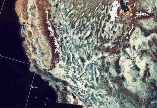
2 Klamath River Basin, Oregon & California Lost River Sub-Basin

3 Lost River Sub-Basin Irrigated Acreages: Surface Water & Groundwater

4 Lost River Sub-Basin Oregon Groundwater Water Right Wells


")
5 Upper Klamath River Basin Surface Hydrogeologic Units and Geologic Structure Gannett & others (2007)


6 Upper Klamath River Basin Geology: Basin and Range Topography


7 Upper Klamath River Basin Geology: Basin-Fill Deposits


8 Upper Klamath River Basin Geology: Basalt/Volcanics Deposits

9 Lost River Sub-Basin Geologic Cross-Section
10 Lost River Sub-Basin Basalt & Basin-Fill Groundwater is Hydraulically Connected


11 Lost River Sub-Basin Deep & Shallow Groundwater is Hydraulically Connected


12 Lost River Sub-Basin Groundwater & Surface Water is Hydraulically Connected


13 Lower Lost River Sub-Basin Groundwater & Surface Water Connection: Primarily Seepage


14 Lower Lost River Sub-Basin Groundwater & Surface Water Connection: Primarily Seepage
15 Lower Lost River Sub-Basin Groundwater - Surface Water: Seepage (No Pumping)
16 Lower Lost River Sub-Basin Groundwater - Surface Water: Seepage (Basin-Fill Pumping)
17 Lower Lost River Sub-Basin Groundwater - Surface Water: Seepage (Basalt Pumping)


18 Lower Lost River Sub-Basin Groundwater - Surface Water Connection: Seepage Barlow & Leake (2012)


 Gannett")
19 Lower Lost River Sub-Basin Groundwater - Surface Water: Seepage (Basalt Pumping) Gannett & Others (2012)


20 Upper Lost River Sub-Basin Groundwater & Surface Water Connection: Springs

21 Upper Lost River Sub-Basin Groundwater & Surface Water Connection: Springs


22 Upper Lost River Sub-Basin Groundwater & Surface Water Connection: Springs


23 Upper Lost River Sub-Basin Groundwater & Surface Water Connection: Springs


24 Upper Lost River Sub-Basin Groundwater & Surface Water Connection: Springs
25 Conclusions 1. Groundwater Occurs in Both Basin-Fill and Basalt Units 2. Groundwater in Deep vs. Shallow Water-Bearing Zones is Connected 3. Groundwater & Surface Water are Connected: Seepage & Springs 4. Groundwater Pumping Causes Surface Water Depletion 5. Depletion Seasonal Magnitude & Duration Varies a. Depletion via Springs is More Acute than via Seepage b. Depletion is Less Acute with Distance c. Depletion is Less Acute with Greater Well Seal Depth 6. Depletion Total Volume Remains the Same Over Time
26 Water Resource Management Consideration 1. Recognize & Decide a. Recognize Total Depletion Volume Over Time Remains the Same b. Recognize Maximum Rate & Duration of Depletion Can Vary c. Decide What to Manage 2. Managing Acuteness of Depletion Rate & Duration a. Continuous Well Casing & Seal Through Basin-Fill Into Basalt b. Greater Distance Between Wells & Surface Water c. Avoid Depletion via Springs as Much as Possible 3. Managing Depletion Maximum Rate & Volume a. Determine Maximum Monthly Depletion Acceptable b. Determine Maximum Monthly GW Pumping Rate Acceptable c. Determine Maximum Annual GW Pumping Volume Acceptable

27 Thank You!!
Construction Dewatering
 Construction Dewatering Introduction The control of groundwater is one of the most common and complicated problems encountered on a construction site. Construction dewatering can become a costly issue
Climate Change and Hydrology in the Sierra Nevada. Lorrie Flint U.S. Geological Survey Sacramento CA
 Climate Change and Hydrology in the Sierra Nevada Lorrie Flint U.S. Geological Survey Sacramento CA Discussion Topics Climate change for California Methods to evaluate hydrologic impacts Water balance
RECHARGE OF THE FRESH WATER AQUIFER IN MANNAR ISLAND. SRILAL JOSEPH PERERA WlJEGOONEWARDENE. B.Sc. (EngO Hons., Sri Lanka
 CP RECHARGE OF THE FRESH WATER AQUIFER IN MANNAR ISLAND BY SRILAL JOSEPH PERERA WlJEGOONEWARDENE B.Sc. (EngO Hons., Sri Lanka A thesis submitted to the University of Moratuwof for the degree of Masters
Temporal Variability of Soil Gas Concentrations and Pressure Under Natural Weather Conditions at Petroleum Hydrocarbon Impacted Sites
 Temporal Variability of Soil Gas Concentrations and Pressure Under Natural Weather Conditions at Petroleum Hydrocarbon Impacted Sites Emma Hong Luo, Ph.D. Chevron Energy Technology Company Houston, TX
Annex P Water Well Modification Plan
 Annex P Water Well Modification Plan Table P1 Table P2 Summary of data Concerning Wells Sampled Summary of New Pump Characteristics H:\WP\1346\Appendices\FEIS\D - Drawdown\CamRdy\App_D.doc Annex P: Water
APPENDIX F GROUNDWATER SAMPLING LOGS
 APPENDIX F GROUNDWATER SAMPLING LOGS Project:Enclave on 241 St Site Location: Bronx Well No: MW07 Date: 10/6/2015 Initial Depth to Water (ft): 15.13 Well Depth (ft): 20.00 Pump Intake Depth (ft): 19 1225
Lecture 8&9: Construction Dewatering
 Arab Academy for Science, Technology & Maritime Transport Colleague of Engineering & Technology Construction & Building Engineering CB 523 Methods and Equipment for Construction 1 Lecture 8&9: Construction
ANNUAL EVALUATION OF 2016 WATER-LEVEL MONITORING DATA FROM THE CITY OF LAS CRUCES WATER SUPPLY WELLS, NEW MEXICO
 ANNUAL EVALUATION OF 216 WATER-LEVEL MONITORING DATA FROM THE CITY OF LAS CRUCES WATER SUPPLY WELLS, NEW MEXICO prepared by Steven T. Finch, Jr., CPG Annie McCoy, CPG Water Resource and Environmental Consultants
3/9/2013. Build house on cliff for a view of the ocean - be one with said view Pearson Education, Inc. Shorelines: summary in haiku form
 Introduction to Environmental Geology, 5e Edward A. Keller Shorelines: summary in haiku form Chapter 11 Coastal Processes Lecture Presentation prepared by X. Mara Chen, Salisbury University Build house
This is a digital document from the collections of the Wyoming Water Resources Data System (WRDS) Library.
 Library.") This is a digital document from the collections of the Wyoming Water Resources Data System (WRDS) Library. For additional information about this document and the document conversion process, please contact
This is a digital document from the collections of the Wyoming Water Resources Data System (WRDS) Library. For additional information about this document and the document conversion process, please contact
ANNUAL EVALUATION OF 2017 WATER LEVEL MONITORING DATA FROM THE CITY OF LAS CRUCES WATER SUPPLY WELLS, NEW MEXICO
 ANNUAL EVALUATION OF 217 WATER LEVEL MONITORING DATA FROM THE CITY OF LAS CRUCES WATER SUPPLY WELLS, NEW MEXICO prepared by prepared for Water Resource and Environmental Consultants www.shomaker.com 55
Merkinch Greenspace. Merkinch Local Nature Reserve: Hydrological Assessment
 Merkinch Local Nature Reserve: Hydrological Assessment June 2011 EnviroCentre Craighall Business Park Eagle Street Glasgow G4 9XA t 0141 341 5040 f 0141 341 5045 w www.envirocentre.co.uk e info@envirocentre.co.uk
Culvert Design for Low and High Gradient Streams in the Midwest. Dale Higgins, Hydrologist Chequamegon-Nicolet National Forest
 Culvert Design for Low and High Gradient Streams in the Midwest Dale Higgins, Hydrologist Chequamegon-Nicolet National Forest Overview Culvert Design Considerations Hydraulic Terms Culvert Impacts Low
Project Incorporation of Sea Level Rise City of Newport Beach Approach for Balboa Islands, City of Newport Beach, California
 Project Incorporation of Sea Level Rise City of Newport Beach Approach for Balboa Islands, City of Newport Beach, California Ying Poon, Everest International Consultants, Inc. CMANC Annual Winter Meeting
Pathways of a conservative contaminant: Infiltration, fracture conduits, and re-emergence of chloride in wells and streams
 Pathways of a conservative contaminant: Infiltration, fracture conduits, and re-emergence of chloride in wells and streams Mark Holden M.S., C.G. Environmental Specialist III John Hopeck, Ph.D. Environmental
W I L D W E L L C O N T R O L PRESSURE BASICS AND CONCEPTS
 PRESSURE BASICS AND CONCEPTS Pressure Basics and Concepts Learning Objectives You will be familiarized with the following basic pressure concepts: Defining pressure Hydrostatic pressure Pressure gradient
Resources. Classroom Conduct. Geology 4182: Physical Hydrogeology Spring 2009 TTH 9:00-10:30 AM E207 Howe-Russell
 Geology 4182: Physical Hydrogeology Spring 2009 TTH 9:00-10:30 AM E207 Howe-Russell Instructor: Jeffrey A. Nunn Office:Room E339 Howe-Russell Telephone:578-3353/0081 e-mail: gljeff@lsu.edu Office hours:
Change in Groundwater Storage for the San Bernardino Basin Area Calendar Years 1934 to 2009
 Change in Groundwater Storage for the San Bernardino Basin Area Calendar Years 1934 to 2009 March 2010 Change in Groundwater Storage for the San Bernardino Basin Area Calendar Years 1934 to 2009 EXECUTIVE
MBMG Butte Mine Flooding Monthly Report BMFOU Consent Decree BU-SEH Remedial Action Monitoring Program Contract No TO-35 September 2013
 MBMG Monthly Report BMFOU Consent Decree 02-35-BU-SEH Remedial Action Monitoring Program Contract No. 400022-TO-35 September 20 The Montana Bureau of Mines and Geology (MBMG) continued to perform monitoring
Coal and Water Protection. PADEP: Well Plugging & Subsurface Activities Division Bureau of Oil and Gas Planning & Program Management
 Coal and Water Protection PADEP: Well Plugging & Subsurface Activities Division Bureau of Oil and Gas Planning & Program Management Review of Applicable Regulations & Laws Coal protective casing: A string
GEOS 5311 Lecture Notes: Numerical Modeling Example, Yucca Mountain, Nevada
 GEOS 5311 Lecture Notes: Numerical Modeling Example, Yucca Mountain, Nevada Dr. T. Brikowski Spring 2010 file:yuccamtn.tex,v (1.11, January 26, 2010), printed March 30, 2011 Introduction 1 Introduction:
2010 Tule Lake Sucker Relocation Project
 2010 Tule Lake Sucker Relocation Project Summary Report June 1, 2010 Prepared for: The Bureau of Reclamation Klamath Basin Area Office Authors: Ian Courter Jay Vaughan Shadia Duery BACKGROUND AND OBJECTIVES
Response of a Newly Created Marsh-Wetland Affected by Tidal Forcing, Upland Discharge, and Groundwater Interaction
 Response of a Newly Created Marsh-Wetland Affected by Tidal Forcing, Upland Discharge, and Groundwater Interaction Mouth of Columbia River, Cape Disappointment State Park, Washington 12 Hans R. Moritz
Deschutes Basin Habitat Conservation Plan. Working Group Meeting December 14, 2017 Redmond, Oregon
 Deschutes Basin Habitat Conservation Plan Working Group Meeting December 14, 2017 Redmond, Oregon AGENDA Welcome and Introductions News and Updates Proposed Conservation Measures Alternative Conservation
Table 1. Monthly precipitation totals from the on-site rain gage and from the Dulles weather station and their differences.
 Table 1. Monthly precipitation totals from the on-site rain gage and from the Dulles weather station and their differences. Precipitation Month On-Site Rain Dulles Weather Difference Ratio 1996-97 Gage
Quick run through of the four projects
 1 Quick run through of the four projects 2 3 4 Vandenberg AFB Study Site. Mobile lab in center. San dune environment. Ground water contamination of TCE at ~18 to 20 feet bgs. 5 This research program addressed
Five Counties Salmonid Conservation Program - Fish Passage Design Workshop. February 2013
 Program - Aquatic Organisms and Stream Crossings Ecological Connectivity A watershed is a network of channels that drain a common boundary. Channel characteristics formed by interaction of precipitation,
RESEARCH ON ENTRANCE TRAINING AND RECLAMATION PROJECT OF DONGSHUIGANG, CHENGMAI COUNTY, HAINAN
 Proceedings of the 7 th International Conference on Asian and Pacific Coasts (APAC 2013) Bali, Indonesia, September 24-26, 2013 RESEARCH ON ENTRANCE TRAINING AND RECLAMATION PROJECT OF DONGSHUIGANG, CHENGMAI
ATCE-II. Construction Dewatering. Advanced Topics in Civil Engineering Construction Dewatering. Professor Kamran M. Nemati Second Semester
 Construction Dewatering ecture 13 The purpose of construction dewatering is to control the surface and subsurface hydrologic environment in such a way as to permit the structure to be constructed in the
Chapter 4: Google Earth Exercise
 Chapter 4: Google Earth Exercise Exercise 1 Visualizing the Three Gorges Dam Hydroelectric Project The Three Gorges Dam was the largest infrastructure project in China since the Great Wall. Completed in
Water Supply Planning for Northeast Illinois
 Water Supply Planning for Northeast Illinois Potential Impacts on the Deep Bedrock Aquifer System Allen Wehrmann, P.E., P.H. (GW), D.WRE Head, Center for Groundwater Science Illinois State Water Survey
BENCH-SCALE INVESTIGATIONS ON VIBRATORY MOBILIZATION OF IMMISCIBLE LIQUID GANGLIA
 BENCH-SCALE INVESTIGATIONS ON VIBRATORY MOBILIZATION OF IMMISCIBLE LIQUID GANGLIA L.N. Reddi *, H. Wu, and J. Nichols, Department of Civil Engineering, Kansas State University, Manhattan, KS, 66506, Phone:
Low pressures to high pressures - how regional overpressure mapping helps find trapped hydrocarbons
 Finding Petroleum Conference London: January 2010 Low pressures to high pressures - how regional overpressure mapping helps find trapped hydrocarbons Richard Swarbrick & Stephen O Connor GeoPressure Technology
ANNUAL EVALUATION OF 2015 WATER LEVEL MONITORING DATA FROM THE CITY OF LAS CRUCES WATER SUPPLY WELLS, NEW MEXICO
 ANNUAL EVALUATION OF 215 WATER LEVEL MONITORING DATA FROM THE CITY OF LAS CRUCES WATER SUPPLY WELLS, NEW MEXICO prepared by Steven T. Finch, Jr., CPG Annie McCoy, CPG Water Resource and Environmental Consultants
Pore-Air Entrapment during Infiltration
 Pore-Air Entrapment during Infiltration GEO-SLOPE International Ltd. www.geo-slope.com 1200, 700-6th Ave SW, Calgary, AB, Canada T2P 0T8 Main: +1 403 269 2002 Fax: +1 888 463 2239 Introduction Infiltration
Downslope Wind Storms
 Downslope Wind Storms How does acceleration over the wing affect pressure field? Equation of Motion for frictionless flow: V t = l k α p+g If we assume a horizontally homogeneous, hydrostatic reference
COASTAL ENVIRONMENTS. 454 lecture 12
 COASTAL ENVIRONMENTS Repeated movement of sediment & water constructs a beach profile reflecting the balance between average daily or seasonal wave forces and resistance of landmass to wave action Coasts
Don Pool and Jeff Kennedy, USGS Brian Conway, Arizona Dept. Water Resources
 USGS Arizona Water Science Center Gravity Program Don Pool and Jeff Kennedy, USGS Brian Conway, Arizona Dept. Water Resources Black Hills Limestone Aquifer Project DUSEL project Sagehen Creek Sierra Nevada
Drought Situations and Management Policy in Vietnam
 Regional Workshop for Asia-Pacific Capacity Development to Support National Drought Management Policy Drought Situations and Management Policy in Vietnam Nguyen Van Tinh, Dang Thanh Mai Hanoi, May 2014
OREGON DEPARTMENT OF FISH AND WILDLIFE REPORT ON INSEASON CHANGES
 Agenda Item E.10.a Supplemental REVISED ODFW Report 1 September 2017 OREGON DEPARTMENT OF FISH AND WILDLIFE REPORT ON INSEASON CHANGES Oregon Research Set-Aside for Yelloweye Rockfish The Oregon Department
TECHNICAL MEMORANDUM 002 EMORANNO. 001
 TECHNICAL MEMORANDUM 002 EMORANNO. 001 To: Jack Synder, P.E. EES Consulting From: Mort McMillen, P.E. Paul Larson, SE Date: October 13, 2010 Project: Cc: Taylor Bowen Subject: Technical Memorandum (TM)
Packer Testing Program Design and Management
 Golden CO; USA Reliable Mine Water Technology IMWA 2013 Packer Testing Program Design and Management Eric E. Swanson¹, Brian C. Titone² ¹AquaLithos Consulting, Principal Consultant, 5360 Cole Circle, Arvada,
8/29/20098 SAHRA - Watershed Visualization
 Module 3 Narration Southwestern Water Cycle 001.wav 26 sec 002.wav 10 sec 003 wav 17 sec Water on Earth is constantly on the move. Water continually circulates between the surface of Earth and the atmosphere
R E M I N D E R S. v Two required essays are due by April 9, v Extra Credit: Think Geographically Essays from any five of the textbook s
 R E M I N D E R S v Two required essays are due by April 9, 2019. Ø A third may be used for extra credit in place of a Think Geographically essay. ESSAY TOPICS (choose any two): Contributions of a noted
Effect of Perched Water Conditions in MSW Landfills: Considerations for Landfill Operators
 Effect of Perched Water Conditions in MSW Landfills: Considerations for Landfill Operators Timothy Townsend and Pradeep Jain Department of Environmental Engineering University of Florida 2005 SWANA Landfill
BEFORE THE PUBLIC UTILITIES COMMISSION OF THE STATE OF CALIFORNIA DIRECT TESTIMONY OF NORMAN C. GROOT
 BEFORE THE PUBLIC UTILITIES COMMISSION OF THE STATE OF CALIFORNIA Application of California-American Water Company (U210W) for Approval of the Monterey Peninsula Water Supply Project and Authorization
Design of Spillway Upgrades
 USACE Dam Safety Program Design of Spillway Upgrades Sal Todaro, P.E. Senior Hydraulic Structures Engineer U.S. Army Corps of Engineers Risk Management Center 1 Presentation Overview 1. USACE (RMC) approach
Water budgets of the two Olentangy River experimental wetlands in 1998
 Water budgets of the two Olentangy River experimental wetlands in 1998 Naiming Wang and William J. Mitsch School of Natural Resources The Ohio State University Water Budgets 17 Introduction An understanding
Dr. Bob Harrington March 2, 2015 Inyo County Water Department 135 South Jackson Street Independence, CA 93526
 Dr. Bob Harrington March 2, 2015 Inyo County Water Department 135 South Jackson Street Independence, CA 93526 RE: Summary of Hydrologic Monitoring Activities February 2015 Rose Valley, Inyo County, California
Hard Hat Services ph: hardhatinc.com 932 N. Wright St., Suite 160 Naperville, IL 60563
 Interstate Power and Light Company Ottumwa Generation Station CCR Surface Impoundment Annual Inspection Report 154.018.015.003 Report issued: July 03, 2017 Hard Hat Services ph: 877-630-7428 hardhatinc.com
Exploring the Wind and Wave Climate in the Great Lakes
 Exploring the Wind and Wave Climate in the Great Lakes R.E. Jensen USACE ERDC Coastal and Hydraulics Laboratory 14 th Waves Workshop 8-13 November 2015 Key West, FL Setting / Motivation North America US:
A Little Math. Wave speed = wave length/wave period C= L/T. Relationship of Wave Length to Depth of Wave Motion
 Ocean Waves 1 2 1 A Little Math Wave speed = wave length/wave period C= L/T 3 Relationship of Wave Length to Depth of Wave Motion 4 2 Motion of Water as Wave Passes Water in the crest of the wave move
OCEAN WAVES NAME. I. Introduction
 NAME OCEAN WAVES I. Introduction The physical definition of a wave is a disturbance that transmits energy from one place to another. In the open ocean waves are formed when wis blowing across the water
Case History. North Sea Platform Wellhead Isolation Tubing Hanger Body Seals Locking Device 20-3/4 x 13-3/8 Mandrel Neck Seal
 Case History North Sea Platform Wellhead Isolation Tubing Hanger Body Seals Locking Device 20-3/4 x 13-3/8 Mandrel Neck Seal History / Introduction: Failed test issues as reported in 2001(SBMS-II, S Seal)
Agenda. REGIONAL REVIEW WELL RESULTS EAST FLANK PLAY FAIRWAY PROSPECTS and LEADS 3D SEISMIC SURVEY NINKY PROSPECT FUNDING ECONOMICS CONCLUSIONS
 PRESENTATION FEBRUARY 2011 1 Agenda 1. 2. 3. 4. 5. 6. 7. 8. 9. REGIONAL REVIEW WELL RESULTS EAST FLANK PLAY FAIRWAY PROSPECTS and LEADS 3D SEISMIC SURVEY NINKY PROSPECT FUNDING ECONOMICS CONCLUSIONS Subsurface
FOR SALE Sprague River Ranch
 FOR SALE Sprague River Ranch Klamath County, OR 30,620 ± Total acres 15,620 Deeded acres 15,000 Leased acres $23,350,000 The Sprague River Ranch is the quintessential combination of a recreational and
CHAPTER 134 INTRODUCTION
 CHAPTER 134 NEW JETTIES FOR TUNG-KANG FISHING HARBOR, TAIWAN Chi-Fu Su Manager Engineering Department Taiwan Fisheries Consultants, Inc. Taipei, Taiwan INTRODUCTION Tung-Kang Fishing Harbor, which is about
THE INEVITABLE RIPPLE 2ND OF APRIL TSUNAMI
 THE INEVITABLE RIPPLE 2ND OF APRIL TSUNAMI Structure Background Preparedness for 2nd of April Response Operations 2nd of April Lessons learnt Future work Hawaii 1957 Background Approx 250,000 people live
Deep-water orbital waves
 What happens when waves approach shore? Deep-water orbital waves Fig. 9.16, p. 211 Wave motion is influenced by water depth and shape of the shoreline wave buildup zone surf zone beach Wave base deepwater
The River Murray System
 The River Murray System Presentation to Engineers Australia Southern Highlands & Tablelands Regional Group 28 April 2011 by Tony Morse (General Manager Assets, MDBA) The Murray-Darling Basin Distribution
Eulachon: State of the Science and Science to Policy Forum
 Eulachon: State of the Science and Science to Policy Forum August 27, 2015 Robert Anderson Eulachon Recovery Coordinator National Marine Fisheries Service FCRPS, Dams, and Water Management in the Columbia
PROPERTIES OF NEARSHORE CURRENTS
 Terry Hendricks PROPERTIES OF NEARSHORE CURRENTS During this past year, we have initiated a program to obtain a better understanding of the properties of the currents flowing over the nearshore shelf area
Role of the oceans in the climate system
 Role of the oceans in the climate system heat exchange and transport hydrological cycle and air-sea exchange of moisture wind, currents, and upwelling gas exchange and carbon cycle Heat transport Two Primary
Ocean Waves. What is a Wave? Where re the waves?!
 Ocean Waves What is a Wave? A response to a generating force (in this case a pebble thrown into a pond) System returns to normal through restoring force (in this case, surface tension of the water) Ripple
MAKE YOUR SAMPLE COUNT! A PRIMER ON COLLECTING QUALITY, REPRESENTATIVE SAMPLES
 TURF MATTERS I BY SAM FERRO President Turf Diagnostics & Design DIAGNOSTIC SPECIAL FOCUS SERVICES REPORT MAKE YOUR SAMPLE COUNT! A PRIMER ON COLLECTING QUALITY, REPRESENTATIVE SAMPLES "Follow the guidelines
2017 Newsletter. Montana AWRA 2017 Conference: Science, Policy & Communication: The role of science in a changing world Aaron Fiaschetti, President
 2017 Newsletter Each year, the Montana Section of the American Water Resources Association (Montana AWRA) holds their annual meeting to encourage water managers, academics, consultants, students, and others
Widow Valley Ranch. Modoc County, California. Proudly Offered By.
 Widow Valley Ranch Modoc County, California Proudly Offered By www.californiaoutdoorproperties.com 707 Merchant Street, Suite 100, Vacaville, Ca 95688 (707) 455-4444 Office (707) 455-0455 Fax info@caoutdoorproperties.com
SOME WATER CHARACTERISTICS OF ESTUARIES IN INDONESIA
 SOME WATER CHARACTERISTICS OF ESTUARIES IN INDONESIA by HENK L. UKTOLSEYA 1 ABSTRACT This paper describes the results obtained during several hydro-oceanographical observations of some estuaries in Indonesia
Deschutes River Conservancy Strategic Plan Executive Summary
 Deschutes River Conservancy Strategic Plan 2015-2025 Executive Summary 1 Mission The mission of the Deschutes River Conservancy (DRC) is to restore stream flow and improve water quality in the Deschutes
Modeling Historic Columbia River Flood Impacts
 Modeling Historic Columbia River Flood Impacts Columbia River Estuary Workshop May 30, 2014 Present by: Lumas Helaire; Graduate Student, Portland State University Andrew Mahedy; Graduate Student, Portland
Utilizing Vessel Based Mobile LiDAR & Bathymetry Survey Techniques for Survey of Four Southern California Breakwaters
 Utilizing Vessel Based Mobile LiDAR & Bathymetry Survey Techniques for Survey of Four Southern California Breakwaters Western Dredging Association: Pacific Chapter September 2012 Insert: Pipe Location
New Locks Alignment at the Pacific Side. Alignment PMD
 New Locks Alignment at the Pacific Side Alignment PMD CHAPTER 1 BACKGROUND Several alignments have been proposed for the construction of a new lane of locks at the Pacific side of the Panama Canal. In
Diver-NETZ Wireless Groundwater Monitoring Networks
 Diver-NETZ Wireless Groundwater Monitoring Networks Monitor your groundwater without boundaries A COMPLETE WIRELESS GROUNDWATER MONITORING SYSTEM From wireless field data collection and recording, to project
October 16, GRDA CCR Landfill Compliance Report Grand River Dam Energy Center 8142 Hwy 412B PO Box 609 Chouteau, OK Dear Mr.
 October 16, 2018 Mr. Mike Bednar Superintendent of Environmental Compliance GRDA-Ecosystems and Education Center PO Box 70 420 Hwy 28 Langley, OK 74350-0070 RE: GRDA CCR Landfill Compliance Report Grand
APPENDIX A1 - Drilling and completion work programme
 APPENDIX A1 - Drilling and completion work programme Information about the well and drilling To the extent possible, the international system of units (SI) should be adhered to, and the drilling programme
30 minutes south of Silicon Valley, California
 Industrial Building & Undeveloped Land 30 minutes south of Silicon Valley, California THE epicenter OF opportunity For Your BUSIness 800 & 810 Salinas Rd., San Juan Bautista, CA 95045 8.63 Acres 2 Parcels
Analyzing Drainage Problems and Applying Proper Drainage Techniques January 6, 2004 I. Analyzing and Classifying Drainage Problems
 Analyzing Drainage Problems and Applying Proper Drainage Techniques January 6, 2004 I. Analyzing and Classifying Drainage Problems The first step in solving drainage problems is properly identifying the
OCN 201 Tides. Tsunamis, Tides and other long waves
 OCN 201 Tides Tsunamis, Tides and other long waves Storm surges Caused by winds and low atmospheric pressure associated with large storms Can raise sea surface by up to 25 ft, bottom contours magnify effect
An Introduction to Deep Foundations
 An Introduction to Deep Foundations J. Paul Guyer, P.E., R.A. Paul Guyer is a registered mechanical engineer, civil engineer, fire protection engineer and architect with over 35 years experience in the
STATELINE RV PARK & MINI STORAGE 4X6 PICTURE
 STATELINE RV PARK & MINI STORAGE 30138 Lower Klamath Road, Tulelake, CA 4X6 PICTURE $650,000 Sales Price Premier Waterfowl Hunting Location Klamath Basin in Tulelake, CA 55 RV Sites & 13,500 SF Mini Storage
Overview and preview. I. Tides as Waves (really really big) What are the Forces driving these waves? II: Into make-believe.
 What are the Forces driving these waves? II: Into make-believe.") The Tides Overview and preview I. Tides as Waves (really really big) What are the Forces driving these waves? II: Into make-believe. Idealized world: no land, deep water, no friction.no problems. Effects
The Tides Overview and preview I. Tides as Waves (really really big) What are the Forces driving these waves? II: Into make-believe. Idealized world: no land, deep water, no friction.no problems. Effects
Stable isotopic composition of groundwater from Mt. Yatsugatake and Mt. Fuji, Japan
 Hydrochemistry (Proceedings of the Rabat Symposium, April 1997) IAHS Publ. no. 244, 1997. 335 Stable isotopic composition of groundwater from Mt. Yatsugatake and Mt. Fuji, Japan MASAYA YASUHARA, ATSUNAO
Amended Written Closure Plan
 Amended Written Closure Plan Valmont Station - Active CCR Impoundments 3A and 3B Public Service Company of Colorado October 17, 2016 Amended January 5, 2018 Table of Contents 1.0 General Information...
Oregon Spotted Frogs 101. Deanna Lynch U.S. Fish and Wildlife Service
 Oregon Spotted Frogs 101 Deanna Lynch U.S. Fish and Wildlife Service Oregon Spotted Frog Background Current Protected Status Federal - Proposed as threatened and proposed designation of critical habitat
Skill of hydrological drought forecasts outperforms meteorological ones
 Skill of hydrological drought forecasts outperforms meteorological ones Samuel J. Sutanto & Henny A. J. Van Lanen Hydrology and Quantitative Water Management Group Wageningen University and Research, the
High Ping Rate Profile Water Mode 12
 Application Note FSA-014 (October 2008) Revised October 2008 High Ping Rate Profile Water Mode 12 Introduction Water Mode 12 is the result of the continued evolution of the signal processing within our
NUMERICAL INVESTIGATION OF COMBINED FLOOD MITIGATION AND GROUNDWATER RECHARGE IN THE CHAO PHRAYA RIVER BASIN
 NUMERICAL INVESTIGATION OF COMBINED FLOOD MITIGATION AND GROUNDWATER RECHARGE IN THE CHAO PHRAYA RIVER BASIN Dr.-Ing. Phatcharasak Arlai 1, Prof. Dr. Manfred Koch 2, Mr. Monthon Yongprawat 1, Ms. Sudarat
Chapter 22, Section 1 - Ocean Currents. Section Objectives
 Chapter 22, Section 1 - Ocean Currents Section Objectives Intro Surface Currents Factors Affecting Ocean Currents Global Wind Belts (you should draw and label a diagram of the global wind belts) The Coriolis
PROPERTY EVALUATION AND RESERVE FUND STUDY ~UPDATE~
 808 S. College, Ste. 225A McKinney, Texas 75069 (972) 562-1011 TEL (972) 540-1031 FAX Firm Reg. No F-4577 www.criteriumdotson.com PROPERTY EVALUATION AND RESERVE FUND STUDY ~UPDATE~ RIVERCHASE OF WYLIE
The Physical and Human Causes of Erosion. The Holderness Coast
 The Physical and Human Causes of Erosion The Holderness Coast By The British Geographer Situation The Holderness coast is located on the east coast of England and is part of the East Riding of Yorkshire;
Practical Application of Buoyancy, Pressure Potential and Buoyancy Reversal within the Context of Regional Groundwater Flow
 International Symposium on Regional Groundwater Flow: Theory, Applications and Future Development Practical Application of Buoyancy, Pressure Potential and Buoyancy Reversal within the Context of Regional
The effect of climate change on South West WA hydrology. Don McFarlane Research Manager
 The effect of climate change on South West WA hydrology Don McFarlane Research Manager Structure of the talk 1. Recent and projected climate change in South West WA i. Rainfall amount and intensity ii.
Appendix A Test Pit Logs
 Appendix A Test Pit Logs Pit number : Test Pit 1 Depth Geological Description Scala Penetrometer (mm) 0-200 Light brown silty Topsoil with some gravel 200-400 Fine to medium GRAVEL; grey. Loosely packed;
Experimental study on the gas tightness of a mined cavern with groundwater
 Experimental study on the gas tightness of a mined cavern with groundwater Yoshinobu Nishimoto a *, Noboru Hasegawa a, and Makoto Nishigaki b a Electric Power Development Co. Ltd., Japan b Okayama University,
Khosla's theory. After studying a lot of dam failure constructed based on Bligh s theory, Khosla came out with the following;
 Khosla's theory After studying a lot of dam failure constructed based on Bligh s theory, Khosla came out with the following; Following are some of the main points from Khosla's Theory From observation
Bathing Water Profile - Loughrea Lake (2013)
") Bathing Water Profile - Loughrea Lake (2013) Bathing Water: Loughrea Lake Bathing Water Code: IEWEBWL29_194_0100 Local Authority: Galway County Council River Basin District: Western Monitoring Point: 162397E,
Bathing Water Profile - Loughrea Lake (2013) Bathing Water: Loughrea Lake Bathing Water Code: IEWEBWL29_194_0100 Local Authority: Galway County Council River Basin District: Western Monitoring Point: 162397E,
Typical factors of safety for bearing capacity calculation in different situations
 Typical factors of safety for bearing capacity calculation in different situations Density of soil: In geotechnical engineering, one deals with several densities such as dry density, bulk density, saturated
Oxbows and Sloughs: Wisconsin s Forgotten Lakes
 University of Massachusetts - Amherst ScholarWorks@UMass Amherst International Conference on Engineering and Ecohydrology for Fish Passage International Conference on Engineering and Ecohydrology for Fish
COMPENSATION LAKE DESIGN CONCEPTS AND CONSTRUCTION LESSONS LEARNED
 SMA Environmental Forum 2016 COMPENSATION LAKE DESIGN CONCEPTS AND CONSTRUCTION LESSONS LEARNED Month A Tale DD, of YYYY Two Lakes Pamela Kuipers, P.Eng., MSc EXPLORE the Depths of our Experience www.norwestcorp.com
Chief Joseph Dam 2012 Two Bay Uplift Spill Test: Total Dissolved Gas Exchange
 U.S. Army Corps of Engineers Seattle District Chief Joseph Dam 2012 Two Bay Uplift Spill Test: Total Dissolved Gas Exchange Prepared by Kent B. Easthouse U.S. Army Corps of Engineers, Seattle District