Pathways of a conservative contaminant: Infiltration, fracture conduits, and re-emergence of chloride in wells and streams
|
|
|
- Isabella Bryant
- 5 years ago
- Views:
Transcription


1 Pathways of a conservative contaminant: Infiltration, fracture conduits, and re-emergence of chloride in wells and streams Mark Holden M.S., C.G. Environmental Specialist III John Hopeck, Ph.D. Environmental Hydrogeology Manager MAINE DEPARTMENT OF ENVIRONMENTAL PROTECTION Protecting Maine s Air, Land and Water
2 Why study chloride? Road salt is applied widely in Maine and chloride is a common contaminant in groundwater and surface waters. Chloride is a conservative contaminant, so there are fewer variables to consider in contaminant migration. There is a large data set available from Maine DOT pre-construction sampling. MAINE DEPARTMENT OF ENVIRONMENTAL PROTECTION
3 Why study chloride? To develop and test risk models that could be applied to diverse conditions of slope, bedrock and overburden geology, and hydrologic soil groups. MAINE DEPARTMENT OF ENVIRONMENTAL PROTECTION
4 Chloride in Streams Many intermittent streams which cross roads to which salt is applied in the wintertime have been observed to show a distinct increase in conductivity downstream of the road Salt appears to be bound up in the soil and slowly released over the course of the year into groundwater and subsequently into the streams as base flow MAINE DEPARTMENT OF ENVIRONMENTAL PROTECTION

5 MAINE DEPARTMENT OF ENVIRONMENTAL PROTECTION

6 MAINE DEPARTMENT OF ENVIRONMENTAL PROTECTION
7 MAINE DEPARTMENT OF ENVIRONMENTAL PROTECTION
8 MAINE DEPARTMENT OF ENVIRONMENTAL PROTECTION

9 MAINE DEPARTMENT OF ENVIRONMENTAL PROTECTION
10 MAINE DEPARTMENT OF ENVIRONMENTAL PROTECTION
11 MAINE DEPARTMENT OF ENVIRONMENTAL PROTECTION
12 MAINE DEPARTMENT OF ENVIRONMENTAL PROTECTION
13 MAINE DEPARTMENT OF ENVIRONMENTAL PROTECTION

14 MAINE DEPARTMENT OF ENVIRONMENTAL PROTECTION
15 MAINE DEPARTMENT OF ENVIRONMENTAL PROTECTION

16 MAINE DEPARTMENT OF ENVIRONMENTAL PROTECTION

17 MAINE DEPARTMENT OF ENVIRONMENTAL PROTECTION

18 MAINE DEPARTMENT OF ENVIRONMENTAL PROTECTION

19 MAINE DEPARTMENT OF ENVIRONMENTAL PROTECTION

20 MAINE DEPARTMENT OF ENVIRONMENTAL PROTECTION

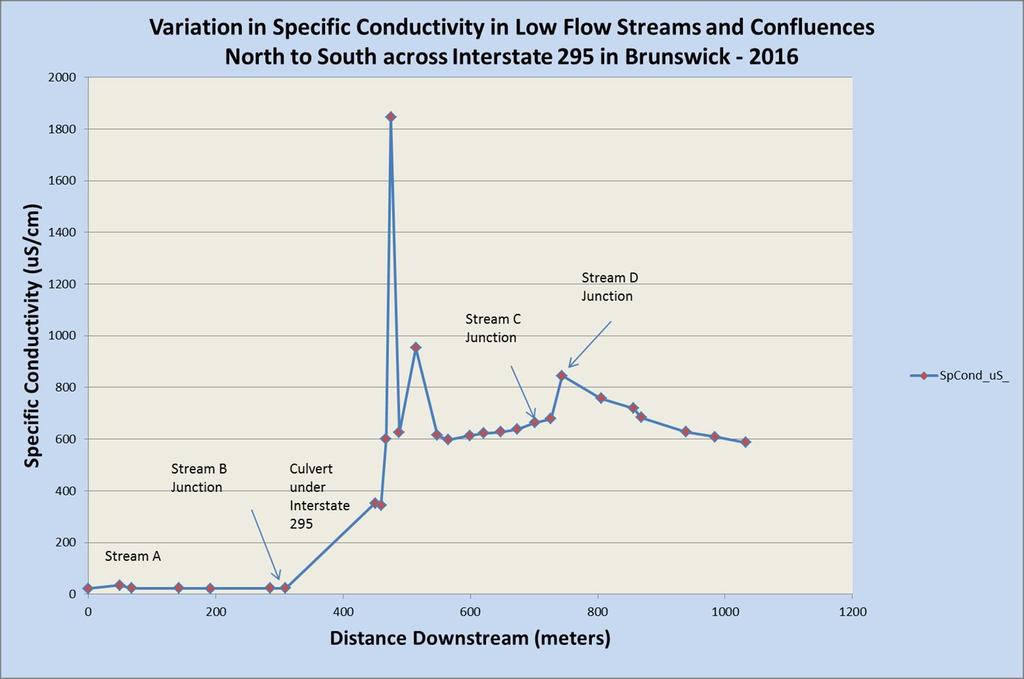
21 Conductivity Variation North to South in Intermittent Streams across Route 295 In Brunswick MAINE DEPARTMENT OF ENVIRONMENTAL PROTECTION
22

23 MAINE DEPARTMENT OF ENVIRONMENTAL PROTECTION

24 Stream conductivity readings from distal upslope (left) across the road to down slope (right): measured in the fall when base flow more closely reflects groundwater. MAINE DEPARTMENT OF ENVIRONMENTAL PROTECTION

25 ROAD ROAD UPSLOPE DOWNSLOPE MAINE DEPARTMENT OF ENVIRONMENTAL PROTECTION
26 Chloride in Residential wells Maine DOT sampled over 5000 wells in pre-construction surveys during wells were spatially located by Maine DEP in the field. These were selected from over 150 different municipalities in spatially diverse geographic settings. Outliers (beyond the second standard deviation) were removed from chloride concentration data. MAINE DEPARTMENT OF ENVIRONMENTAL PROTECTION

27 MAINE DEPARTMENT OF ENVIRONMENTAL PROTECTION
28 2D Spatial Parameters Well capture zone: 75-foot radius Proximal area: < 75 feet from road centerline Overlap zone: feet from road centerline Distal zone: > 150 feet from road centerline MAINE DEPARTMENT OF ENVIRONMENTAL PROTECTION


29 Example: numbers reflect chloride results in PPM at residential wells MAINE DEPARTMENT OF ENVIRONMENTAL PROTECTION

30 Results from preliminary study ( ) MAINE DEPARTMENT OF ENVIRONMENTAL PROTECTION


31 Comparison of mean chloride results for well captures for different degree slope areas. MAINE DEPARTMENT OF ENVIRONMENTAL PROTECTION


32 What is causing higher chloride results in areas with slope greater than 2-3 degrees? Culverts? Sand? Ice dams? Increasing runoff flow rates? MAINE DEPARTMENT OF ENVIRONMENTAL PROTECTION
33
34
35 Hydrologic Soil Groups (HSG) HSG (A + B): generally more permeable HSG (C + D): generally less permeable In the statewide STATSGO layer, predominant hydrologic types (of usually three soils) were used to defined these groupings The less-than-statewide but more detailed SSURGO layer shows the individual A, B, C, and D hydrologic types MAINE DEPARTMENT OF ENVIRONMENTAL PROTECTION


36 Hydrologic Soil Groupings: A+B: Green C+D: Light blue MAINE DEPARTMENT OF ENVIRONMENTAL PROTECTION


37 Example from Gorham, Maine: Brackett Street: Hydrologic Soil Groups Distribution MAINE DEPARTMENT OF ENVIRONMENTAL PROTECTION

38 CHLORIDE MEAN VALUES (PPM) ALL SPATIAL ZONES - ALL WELLS - BROKEN OUT INTO A+B AND C+D HYDROLOGIC GROUPS (outliers removed) Do the slower infiltrating C+D hydrologic soil groups retain more road salt while the faster infiltrating A+B groups allow it to disperse? HG_A+B HG_C+D DISTAL_UP OVERLAP_UP PROXIMAL_UP PROXIMAL_DOWN OVERLAP_DOWN DISTAL_DOWN WELL CAPTURE ZONES (PROXIMAL TO DISTAL) RELATIVE TO CENTERLINE OF ROAD MAINE DEPARTMENT OF ENVIRONMENTAL PROTECTION
 and lower infiltrating (C+D) soils 60 53.68 53.54 54.69 50 40 47.58 45.32 48.")
39 CHLORIDE MEAN VALUES (PPM) ALL SPATIAL ZONES - ALL WELLS - BROKEN OUT INTO A+B AND C+D HYDROLOGIC GROUPS (outliers removed) A comparison of Chloride results in well capture zones between drilled and dug wells and higher infiltrating (A+B) and lower infiltrating (C+D) soils DUG_WP_HSG (173) DRILLED (721) HG_A+B (315) HG_C+D (666) 10 0 DISTAL_UP OVERLAP_UP PROXIMAL_UP PROXIMAL_DOWN OVERLAP_DOWN DISTAL_DOWN WELL CAPTURE ZONES (PROXIMAL TO DISTAL) RELATIVE TO CENTERLINE OF ROAD MAINE DEPARTMENT OF ENVIRONMENTAL PROTECTION
 versus higher infiltration rates (Hydrologic A+B soils) HG_C+D 150 HG_A+B 100 50 0 0 50 100 150 200 250 300 350 DISTANCE (METERS) MAINE DEPARTMENT OF ENVIRONMENTAL PROTECTION www.maine.")
40 CHLORIDE RESULTS (PPM) CHLORIDE (PPM) IN 300 METER CROSS SECTION OF ROAD Distribution of chloride results perpendicular to roads: lower infiltration rates (Hydrologic C+D soils) versus higher infiltration rates (Hydrologic A+B soils) HG_C+D 150 HG_A+B DISTANCE (METERS) MAINE DEPARTMENT OF ENVIRONMENTAL PROTECTION
 versus downslope (positive distance -")

41 Distribution of chloride results upslope (negative distance - left) versus downslope (positive distance - right): Low slope areas. Different hydrologic soils and well types. MAINE DEPARTMENT OF ENVIRONMENTAL PROTECTION

42 Distribution of chloride results upslope (negative distance - left) versus downslope (positive distance - right): Medium slope areas. Different hydrologic soils and well types. MAINE DEPARTMENT OF ENVIRONMENTAL PROTECTION
 versus downslope (positive distance - right):")

43 Distribution of chloride results upslope (negative distance - left) versus downslope (positive distance - right): Higher slope areas. Different hydrologic soils and well types. MAINE DEPARTMENT OF ENVIRONMENTAL PROTECTION
 versus downslope (positive distance - right): Steep")

44 Distribution of chloride results upslope (negative distance - left) versus downslope (positive distance - right): Steep slope areas. Different hydrologic soils and well types. MAINE DEPARTMENT OF ENVIRONMENTAL PROTECTION
45 Effect of bedrock fractures Does bedrock fractures (joints, fracture cleavage) orientation have an effect on hydrologic movement of road salt in the groundwater? How to proceed: Identify principal fracture directions Concentrate on higher angle fracture planes (>40 degrees of dip) Measure within as close a proximity to well data as possible Do stereoscopic projection analysis (rose diagrams) to determine dominant trends Determine the well to road declination as well as declination of the tangential perpendicular at the road for each well MAINE DEPARTMENT OF ENVIRONMENTAL PROTECTION

46 Road Salt Hydrologic Analysis Western Maine Road Salt Analysis: Regional Fracture Orientations MAINE DEPARTMENT OF ENVIRONMENTAL PROTECTION


47 Strike Angle and Dip Slope Measurements Brunton Compass MAINE DEPARTMENT OF ENVIRONMENTAL PROTECTION

48 MAINE DEPARTMENT OF ENVIRONMENTAL PROTECTION
49 MAINE DEPARTMENT OF ENVIRONMENTAL PROTECTION

50 MAINE DEPARTMENT OF ENVIRONMENTAL PROTECTION

51 MAINE DEPARTMENT OF ENVIRONMENTAL PROTECTION

52 MAINE DEPARTMENT OF ENVIRONMENTAL PROTECTION
53 Mean Chloride % 60 Percentage Distribution of Normalized Chloride Data in 30 meter increments perpencular to the road (Upslope (left) and Downslope (right)) - Hancock_Sullivan (Rt. 1) - outlier (1) SIN.13_.99_P1_76_Samples_100% 50 SIN.13_.80_P1_38_Samples_38.96% SIN.81_.99_P1_38_Samples_61.04% Meters 20 Road Center METER INTERVALS UPSLOPE (LEFT) TO DOWNSLOPE (RIGHT) MAINE DEPARTMENT OF ENVIRONMENTAL PROTECTION
54 MAINE DEPARTMENT OF ENVIRONMENTAL PROTECTION


55 Determination of Topographic Slope Angle using ArcMap Tool: Aspect MAINE DEPARTMENT OF ENVIRONMENTAL PROTECTION

56 MAINE DEPARTMENT OF ENVIRONMENTAL PROTECTION

57 MAINE DEPARTMENT OF ENVIRONMENTAL PROTECTION

58 MAINE DEPARTMENT OF ENVIRONMENTAL PROTECTION
59 Mean Chloride % Percentage Distribution of Normalized Chloride Data in 30 meter Increments perpencular to the road and in relation to the direction of the Primary Fracture Direction (P1)- Orrington (River Road) - all data SIN.69_1.00_P1_ 90 Samples_100% SIN.85_1.00_P1_63_Samples_77.82% SIN.69_.84_P1_27_Samples_22.18% Meters Road Center METER INTERVALS UPSLOPE (LEFT) TO DOWNSLOPE (RIGHT) MAINE DEPARTMENT OF ENVIRONMENTAL PROTECTION

60 MAINE DEPARTMENT OF ENVIRONMENTAL PROTECTION
61 Mean Chloride % Durham_Freeport (Rte. 136) Drilled Wells Only - outlier removed SIN.61_.99_P1_79_Samples_100% SIN.82_.99_P1_63_Samples_74.4% SIN.61_.81_P1_16_Samples_25.6% Road Center Meters METER INTERVALS UPSLOPE (LEFT) TO DOWNSLOPE (RIGHT) MAINE DEPARTMENT OF ENVIRONMENTAL PROTECTION


62 MAINE DEPARTMENT OF ENVIRONMENTAL PROTECTION
63 Mean Chloride % 50 Robbinston_Perry (Rt. 1) -(P2) - outliers (2) removed SIN.72_.94_P2_67 Samples_100% SIN.95_.1.00_P2_47Samples_65.93% SIN.72_.94_P2_20 Samples_34.06% Meters Road Center METER INTERVALS UPSLOPE (LEFT) TO DOWNSLOPE (RIGHT) MAINE DEPARTMENT OF ENVIRONMENTAL PROTECTION
64 Road Salt in solution Does the salt solution move out or down within the soils and bedrock? Does it concentrate at shallow depths or deep?: MAINE DEPARTMENT OF ENVIRONMENTAL PROTECTION

65 MAINE DEPARTMENT OF ENVIRONMENTAL PROTECTION
66 Depth (feet) Well Depth Profile for Conductivity and Temperature Winslow, 1000 ft. NE of SSP MicroSiemans/Cm or Temperature (C) 65 Ft Water Bearing Zone 120 Ft Water Bearing Zone TDS_PPM Temperature_C MAINE DEPARTMENT OF ENVIRONMENTAL PROTECTION
67 MAINE DEPARTMENT OF ENVIRONMENTAL PROTECTION
68 Objective: A Predictive Model for Road Salt Hydraulic Behavior in consideration of: A. Residence time: of salt and/or salt solute 1. based on hydrologic soil type and underlying surficial geology 2. based on degree of topographic slope 3. culvert and ditch configuration: presence or absence, size B. Regional Primary Bedrock Fracture Orientation MAINE DEPARTMENT OF ENVIRONMENTAL PROTECTION
 MAINE DEPARTMENT OF ENVIRONMENTAL PROTECTION www.maine.")
69 Where: a = ht. of peak (1) b = center of peak (19.64) c = stand. dev. (53.97) MAINE DEPARTMENT OF ENVIRONMENTAL PROTECTION
 215-1691")


70 Mark Holden (207) MAINE DEPARTMENT OF ENVIRONMENTAL PROTECTION
APPENDIX J HYDROLOGY AND WATER QUALITY
 APPENDIX J HYDROLOGY AND WATER QUALITY J-1 Technical Report on Airport Drainage, Northern Sector Airport and Ordinance Creek Watershed / Preliminary Creek Constructed Natural Channel Culvert J-2 Preliminary
Importance of un-named tributary streams to Brook Trout populations. Dr. Jonathan M. Niles Dr. Dan Ressler
 Importance of un-named tributary streams to Brook Trout populations. Dr. Jonathan M. Niles Dr. Dan Ressler Pennsylvania Streams All streams of PA have a designated use - Huge resource - 8,011 named tributaries:
Final Bull Trout Redd Monitoring Report for the Wallowa Falls Hydroelectric Project
 Final for the Wallowa Falls Hydroelectric Project East Fork Wallowa River barrier to upstream fish migration, photo courtesy of Kendrick Moholt (FERC No. P-308) December 18, 2017 Prepared by: Jeremiah
Pore-Air Entrapment during Infiltration
 Pore-Air Entrapment during Infiltration GEO-SLOPE International Ltd. www.geo-slope.com 1200, 700-6th Ave SW, Calgary, AB, Canada T2P 0T8 Main: +1 403 269 2002 Fax: +1 888 463 2239 Introduction Infiltration
TRAFFIC CHARACTERISTICS. Unit I
 TRAFFIC CHARACTERISTICS Unit I Traffic stream Characteristics Overview Overview of Traffic Stream Components To begin to understand the functional and operational aspects of traffic on streets and highways
Currents measurements in the coast of Montevideo, Uruguay
 Currents measurements in the coast of Montevideo, Uruguay M. Fossati, D. Bellón, E. Lorenzo & I. Piedra-Cueva Fluid Mechanics and Environmental Engineering Institute (IMFIA), School of Engineering, Research
Study Update Tailrace Slough Use by Anadromous Salmonids
 Study Update Tailrace Slough Use by Anadromous Salmonids Goals and Objectives Identify what anadromous salmonids use the tailrace slough by: Life Stage (Juvenile, migrating and spawning adults) Timing
SPM Version 3 Orientation Learning Exercise - Loading Rates Answer Key
 SPM Version 3 Orientation Learning Exercise - Loading Rates Answer Key These exercises are intended to support your self-directed learning. Answer the questions based on the SPM Version 3 standards and
10.6 The Dynamics of Drainage Flows Developed on a Low Angle Slope in a Large Valley Sharon Zhong 1 and C. David Whiteman 2
 10.6 The Dynamics of Drainage Flows Developed on a Low Angle Slope in a Large Valley Sharon Zhong 1 and C. David Whiteman 2 1Department of Geosciences, University of Houston, Houston, TX 2Pacific Northwest
Annex P Water Well Modification Plan
 Annex P Water Well Modification Plan Table P1 Table P2 Summary of data Concerning Wells Sampled Summary of New Pump Characteristics H:\WP\1346\Appendices\FEIS\D - Drawdown\CamRdy\App_D.doc Annex P: Water
TECHNICAL MEMORANDUM 002 EMORANNO. 001
 TECHNICAL MEMORANDUM 002 EMORANNO. 001 To: Jack Synder, P.E. EES Consulting From: Mort McMillen, P.E. Paul Larson, SE Date: October 13, 2010 Project: Cc: Taylor Bowen Subject: Technical Memorandum (TM)
Chinook Salmon Spawning Study Russian River Fall 2005
 Chinook Salmon Spawning Study Russian River Fall 2005 Sonoma County Water Agency 2150 West College Avenue Santa Rosa, California 95401 Prepared by David Cook - Senior Environmental Specialist March 27,
(Revised February,2005) CULVERTS, BRIDGES, AND FORDS
 CULVERTS, BRIDGES, AND FORDS") GUIDE TO STREAM CROSSINGS (Revised February,2005) CULVERTS, BRIDGES, AND FORDS Culverts, bridges, and fords are all methods used to cross-streams. Culverts are the most common stream crossing structure.
GUIDE TO STREAM CROSSINGS (Revised February,2005) CULVERTS, BRIDGES, AND FORDS Culverts, bridges, and fords are all methods used to cross-streams. Culverts are the most common stream crossing structure.
Stream Assessment Cut-block: For: Island Timberlands Limited Partnership, Cameron Operation
 Stream Assessment Cut-block: 171214 For: Island Timberlands Limited Partnership, Cameron Operation Tony Norris Area Engineer Island Timberlands Cameron Operation Port Alberni D.G. Rigets E.I.A. CTech.
CROSS-SHORE SEDIMENT PROCESSES
 The University of the West Indies Organization of American States PROFESSIONAL DEVELOPMENT PROGRAMME: COASTAL INFRASTRUCTURE DESIGN, CONSTRUCTION AND MAINTENANCE A COURSE IN COASTAL DEFENSE SYSTEMS I CHAPTER
HEC 26 Aquatic Organism Passage Design Manual Evolution & Application
 HEC 26 Aquatic Organism Passage Design Manual Evolution & Application Sven Leon, P.E., Hydraulics Engineer Federal Highway Administration 2015 Alaska Fish Passage Meeting October 13 14, 2015 VTRC, Juneau,
RULES OF THE OIL AND GAS PROGRAM DIVISION OF WATER RESOURCES CHAPTER DRILLING WELLS TABLE OF CONTENTS
 RULES OF THE OIL AND GAS PROGRAM DIVISION OF WATER RESOURCES CHAPTER 0400-52-06 DRILLING WELLS TABLE OF CONTENTS 0400-52-06-.01 Drilling Equipment 0400-52-06-.03 Casingheads 0400-52-06-.02 Blowout Prevention
Road Design Guidelines for Low Impact to Hydrology *
 Five Counties Salmonid Conservation Program P.O. Box 2819 Weaverville, CA 96093 (530) 623-1351 Ext. 5 FAX (530) 623-1353 email: mlancaster@trinitycounty.org Road Design Guidelines for Low Impact to Hydrology
RECHARGE OF THE FRESH WATER AQUIFER IN MANNAR ISLAND. SRILAL JOSEPH PERERA WlJEGOONEWARDENE. B.Sc. (EngO Hons., Sri Lanka
 CP RECHARGE OF THE FRESH WATER AQUIFER IN MANNAR ISLAND BY SRILAL JOSEPH PERERA WlJEGOONEWARDENE B.Sc. (EngO Hons., Sri Lanka A thesis submitted to the University of Moratuwof for the degree of Masters
Alewife Brook, Cape Elizabeth, River Herring Monitoring Summary 2015
 University of Southern Maine USM Digital Commons Publications Casco Bay Estuary Partnership (CBEP) 2-3-2016 Alewife Brook, Cape Elizabeth, River Herring Monitoring Summary 2015 Matt Craig University of
Indiana LTAP Road Scholar Core Course #10 Culvert Drainage. Presented by Thomas T. Burke, Jr., PhD, PE Christopher B. Burke Engineering, Ltd.
 Indiana LTAP Road Scholar Core Course #10 Culvert Drainage Presented by Thomas T. Burke, Jr., PhD, PE Christopher B. Burke Engineering, Ltd. Objectives Review culvert shapes, end sections, and materials
ROAD OCCUPANCY PERMIT APPLICATION # Damascus Township, 60 Conklin Hill Road, Damascus, PA Tel Fax
 Instructions: For a driveway access permit, fill in sections 1, 2, 3 and 4, and the appropriate drawings and sign. For a Utility access, fill in sections 1, 2, 3 and 5, and figures 1 and 3. Prepare a detailed
Minnesota Department of Natural Resources Division of Fish and Wildlife Section of Fisheries. Stream Survey Report. Luxemburg Creek.
 Minnesota F-29-R(P)-24 Area 315 Study 3 March 2016 Minnesota Department of Natural Resources Division of Fish and Wildlife Section of Fisheries Stream Survey Report Luxemburg Creek 2015 Mark Pelham Sauk
Khosla's theory. After studying a lot of dam failure constructed based on Bligh s theory, Khosla came out with the following;
 Khosla's theory After studying a lot of dam failure constructed based on Bligh s theory, Khosla came out with the following; Following are some of the main points from Khosla's Theory From observation
Location: HSU campus Founders Hall - Van Matre Hall vicinity and campus to west and south.
 Objectives: GEOLOGY 470: FIELD EXERCISE 1 SPRING 2007-- BASIC SURVEYING AND COMPASS USE 1. Determine pace, eye height, and height for use in rough surveying 2. Learn basic compass skills: reading, setting
Enbridge G & P (East Texas) LP EXAMINER S REPORT AND PROPOSAL FOR DECISION STATEMENT OF THE CASE
 LP EXAMINER S REPORT AND PROPOSAL FOR DECISION STATEMENT OF THE CASE") OIL AND GAS DOCKET NO. 05-0263914 THE APPLICATION OF ENBRIDGE G & P (EAST TEXAS) LP FOR AUTHORITY PURSUANT TO STATEWIDE RULES 9 AND 36 TO DISPOSE OF OIL AND GAS WASTE CONTAINING HYDROGEN SULFIDE INTO ITS
OIL AND GAS DOCKET NO. 05-0263914 THE APPLICATION OF ENBRIDGE G & P (EAST TEXAS) LP FOR AUTHORITY PURSUANT TO STATEWIDE RULES 9 AND 36 TO DISPOSE OF OIL AND GAS WASTE CONTAINING HYDROGEN SULFIDE INTO ITS
Comparison of Predicted and Measured Shoaling at Morro Bay Harbor Entrance, California
 Comparison of Predicted and Measured Shoaling at Morro Bay Harbor Entrance, California by Edward F. Thompson, Inocencio P. DiRamos, and Robert R. Bottin, Jr. PURPOSE: This Coastal and Hydraulics Engineering
Plan B Dam Breach Assessment
 Plan B Dam Breach Assessment Introduction In support of the Local Sponsor permit applications to the states of Minnesota and North Dakota, a dam breach analysis for the Plan B alignment of the Fargo-Moorhead
An Introduction to Deep Foundations
 An Introduction to Deep Foundations J. Paul Guyer, P.E., R.A. Paul Guyer is a registered mechanical engineer, civil engineer, fire protection engineer and architect with over 35 years experience in the
Greens Playing Quality
 Greens Playing Quality STERF Seminar Copenhagen and Hoor for excellence in sports surfaces www.stri.co.uk Conor Nolan STRI Turf Agronomist for excellence in sports surfaces www.stri.co.uk Introduction
Temporal Variability of Soil Gas Concentrations and Pressure Under Natural Weather Conditions at Petroleum Hydrocarbon Impacted Sites
 Temporal Variability of Soil Gas Concentrations and Pressure Under Natural Weather Conditions at Petroleum Hydrocarbon Impacted Sites Emma Hong Luo, Ph.D. Chevron Energy Technology Company Houston, TX
Data Collection and Processing: Elwha Estuary Survey, February 2013
 Data Collection and Processing: Elwha Estuary Survey, February 2013 Ian Miller, WA Sea Grant Olympic Peninsula Field Office, 1502 E. Lauridsen Blvd #82, Port Angeles, WA 98362 immiller@u.washington.edu
NIANGUA SNAPSHOT ISSUE Nutrients 2 Suspended Sediment 3 Salinity 4 Summary 5
 Niangua River Watershed Snapshot Volume 14 Number 2 The 125-mile long Niangua River meanders northward from the town of Marshfield on I-44 to the Lake of the Ozarks. Its watershed covers more than 658,000
Design Assessment Checklist: Infiltration / Detention Basin
 Design Assessment Checklist: Infiltration / Detention Basin Objectives This checklist can be used by the organisation approving the drainage scheme (drainage approving body) to help assess submissions
Technical Report Culvert A Hydraulic Analysis
 DATE: November 3, 2011 Technical Report Culvert A Hydraulic Analysis TO: FROM: RE: Jim Reiser, P.E. Project Manager Parsons Brinckerhoff, Inc. Kurt Killian, P.E., CFM Parsons Brinckerhoff, Inc. Design
Near-Field Sturgeon Monitoring for the New NY Bridge at Tappan Zee. Quarterly Report July 1 September 30, 2014
 Near-Field Sturgeon Monitoring for the New NY Bridge at Tappan Zee Quarterly Report July 1 September 30, 2014 Prepared by AKRF, Inc. 7250 Parkway Drive, Suite 210 Hanover, MD 21076 for New York State Thruway
White Paper. Draft Variable Depth Root Zones for Golf Putting Greens. James Crum and Trey Rogers. Michigan State University.
 White Paper Draft Variable Depth Root Zones for Golf Putting Greens James Crum and Trey Rogers Michigan State University January 2017 Variable-Depth Root Zones for Golf Putting Greens Introduction The
Trout Unlimited Comments on the Scope of Environmental Impact Statement for the Constitution Pipeline Project, Docket No. PF12-9
 October 9, 2012 Kimberly D. Bose, Secretary Federal Energy Regulatory Commission 888 First Street, NE, Room 1A Washington, DC 20426 RE: Trout Unlimited Comments on the Scope of Environmental Impact Statement
Effect of Limited Water Supplies on Center Pivot Performance
 Abstract Effect of Limited Water Supplies on Center Pivot Performance by Derrel Martin Professor Irrigation and Water Resources Engineering University of Nebraska Lincoln Lincoln, NE Performance of a center
Tutorial for the. Total Vertical Uncertainty Analysis Tool in NaviModel3
 Tutorial for the Total Vertical Uncertainty Analysis Tool in NaviModel3 May, 2011 1. Introduction The Total Vertical Uncertainty Analysis Tool in NaviModel3 has been designed to facilitate a determination
PREDICTING TEXTURE DEFICIENCY IN PAVEMENT MANAGEMENT PREDICTING TEXTURE DEFICIENCY IN PAVEMENT MANAGEMENT
 PREDICTING TEXTURE DEFICIENCY IN PAVEMENT MANAGEMENT Sean Rainsford Chris Parkman MWH NZ Ltd Transit New Zealand PREDICTING TEXTURE DEFICIENCY IN PAVEMENT MANAGEMENT Inadequate texture is one of the key
COMPARISON OF CONTEMPORANEOUS WAVE MEASUREMENTS WITH A SAAB WAVERADAR REX AND A DATAWELL DIRECTIONAL WAVERIDER BUOY
 COMPARISON OF CONTEMPORANEOUS WAVE MEASUREMENTS WITH A SAAB WAVERADAR REX AND A DATAWELL DIRECTIONAL WAVERIDER BUOY Scott Noreika, Mark Beardsley, Lulu Lodder, Sarah Brown and David Duncalf rpsmetocean.com
Michigan Department of Natural Resources Status of the Fishery Resource Report Page 1
 Michigan Department of Natural Resources 2007-33 Status of the Fishery Resource Report Page 1 Grand Sable Lake Alger County, T49N, R14W, Sec. Many Lake Superior watershed, last year surveyed 2004 James
METHODS PAPER: Downstream Bathymetry and BioBase Analyses of Substrate and Macrophytes
 Mactaquac Aquatic Ecosystem Study Report Series 2015-006 METHODS PAPER: Downstream Bathymetry and BioBase Analyses of Substrate and Macrophytes Ben Wallace, Jae Ogilvie and Wendy Monk 17 February 2015
Undertow - Zonation of Flow in Broken Wave Bores
 Nearshore Circulation Undertow and Rip Cells Undertow - Zonation of Flow in Broken Wave Bores In the wave breaking process, the landward transfer of water, associated with bore and surface roller decay
Annex E Bridge Pier Protection Plan
 Annex E Bridge Pier Protection Plan Table E1 Bridge Types and Locations Table E2 Flow Conditions For River Sections Figure E1 Bridge Abutment Protection Figure E2 Bridge Pier Protection Figure E3 Central
Five Counties Salmonid Conservation Program - Fish Passage Design Workshop. February 2013
 Program - Aquatic Organisms and Stream Crossings Ecological Connectivity A watershed is a network of channels that drain a common boundary. Channel characteristics formed by interaction of precipitation,
Hydraulic Evaluation of the Flow over Polyhedral Morning Glory Spillways
 World Applied Sciences Journal 9 (7): 712-717, 2010 ISSN 1818-4952 IDOSI Publications, 2010 Hydraulic Evaluation of the Flow over Polyhedral Morning Glory Spillways 1 2 2 A. Bagheri, M. Shafai Bajestan,
Final Bull Trout Genetics Monitoring Plan for the Wallowa Falls Hydroelectric Project. (FERC No. P-308) June 2017
 June 2017") Final for the Wallowa Falls Hydroelectric Project (FERC No. P-308) June 2017 Prepared by: Jeremiah Doyle PacifiCorp 825 NE Multnomah Street Portland, OR 97232 June, 2017 Page 1 of 8 Table of Contents 1.0
Final for the Wallowa Falls Hydroelectric Project (FERC No. P-308) June 2017 Prepared by: Jeremiah Doyle PacifiCorp 825 NE Multnomah Street Portland, OR 97232 June, 2017 Page 1 of 8 Table of Contents 1.0
Kerry A. Pollard Texstar Midstream Utility, LP Gallon E. Gray Phillip Zamzow EXAMINER S REPORT AND RECOMMENDATION STATEMENT OF THE CASE
 OIL AND GAS DOCKET NO. 01-0271975 THE APPLICATION OF TEXSTAR MIDSTREAM UTILITY, LP FOR AUTHORITY PURSUANT TO STATEWIDE RULES 9 AND 36 TO DISPOSE OF OIL AND GAS WASTE CONTAINING HYDROGEN SULFIDE INTO THE
3. GRADUALLY-VARIED FLOW (GVF) AUTUMN 2018
 AUTUMN 2018") 3. GRADUALLY-VARIED FLOW (GVF) AUTUMN 2018 3.1 Normal Flow vs Gradually-Varied Flow V 2 /2g EGL (energy grade line) Friction slope S f h Geometric slope S 0 In flow the downslope component of weight balances
3. GRADUALLY-VARIED FLOW (GVF) AUTUMN 2018 3.1 Normal Flow vs Gradually-Varied Flow V 2 /2g EGL (energy grade line) Friction slope S f h Geometric slope S 0 In flow the downslope component of weight balances
Cove Point Beach Restoration: Utilization of a Spawning Habitat by Horseshoe Crabs (Limulus polyphemus)
") Cove Point Beach Restoration: Utilization of a Spawning Habitat by Horseshoe Crabs (Limulus polyphemus) Paul Bushmann, Jessica Peterson, Bethany Enyeart and Deborah Smith Anne Arundel Community College
Cove Point Beach Restoration: Utilization of a Spawning Habitat by Horseshoe Crabs (Limulus polyphemus) Paul Bushmann, Jessica Peterson, Bethany Enyeart and Deborah Smith Anne Arundel Community College
TRIAXYS Acoustic Doppler Current Profiler Comparison Study
 TRIAXYS Acoustic Doppler Current Profiler Comparison Study By Randolph Kashino, Axys Technologies Inc. Tony Ethier, Axys Technologies Inc. Reo Phillips, Axys Technologies Inc. February 2 Figure 1. Nortek
Gerald H. Grondin Oregon Water Resources Department Groundwater Hydrology Section Salem, Oregon. Lost River Groundwater Surface Water Management
 Geologic Framework Influence On Managing Groundwater Interference With Surface Water, A Lost River Sub-Basin Example, Upper Klamath River Basin, Oregon Gerald H. Grondin Oregon Water Resources Department
How Fast Can You Throw?
 Name Date Period How Fast Can You Throw? Directions: Find a spot 40 feet from a wall and mark it with a piece of chalk. From that point, you will throw the ball 5 times with your right hand, and then five
Kenai River Sockeye Escapement Goals. United Cook Inlet Drift Association
 Kenai River Sockeye Escapement Goals United Cook Inlet Drift Association 2014 Evaluating Sockeye Escapement Goals in the Kenai River Utilizing Brood Tables and Markov Tables This presentation pertains
Discussion on the Selection of the Recommended Fish Passage Design Discharge
 Discussion on the Selection of the Recommended Fish Passage Design Discharge Introduction The provision of fish passage is a requirement for most proposed culvert and bridge installations in Alberta, depending
NERC GEOPHYSICAL EQUIPMENT FACILITY LOAN 904 SCIENTIFIC REPORT
 NERC GEOPHYSICAL EQUIPMENT FACILITY LOAN 904 SCIENTIFIC REPORT M. Disney, N. MacBean Department of Geography, University College London, Pearson Building, Gower Street, London, WC1E 6BT. Tel. 020 7679
Climate Change and Hydrology in the Sierra Nevada. Lorrie Flint U.S. Geological Survey Sacramento CA
 Climate Change and Hydrology in the Sierra Nevada Lorrie Flint U.S. Geological Survey Sacramento CA Discussion Topics Climate change for California Methods to evaluate hydrologic impacts Water balance
Fine-Scale Survey of Right and Humpback Whale Prey Abundance and Distribution
 DISTRIBUTION STATEMENT A. Approved for public release; distribution is unlimited. Fine-Scale Survey of Right and Humpback Whale Prey Abundance and Distribution Joseph D. Warren School of Marine and Atmospheric
EXAMINER S REPORT AND RECOMMENDATION STATEMENT OF THE CASE
 OIL AND GAS DO0KET NO. 01-0249550 THE APPLICATION OF REGENCY FS LP UNDER RULE 36 AND RULE 46 TO DISPOSE OF OIL AND WASTE CONTAINING HYDROGEN SULFIDE GAS INTO ITS TILDEN GPI WELL NO. 1, TILDEN, S. (WILCOX
Seismic Survey Designs for Converted Waves
 Seismic Survey Designs for Converted Waves James A. Musser* GMG/AXIS Inc., Denver, CO 1720 Red Cloud Road, Longmont, CO, 80501, USA jmusser@gmg.com ABSTRACT Designing converted wave 3D surveys is considerably
CHAPTER 4 SPALDING COUNTY, GEORGIA 4.0 CULVERT DESIGN
 SPALDING COUNTY, GEORGIA CHAPTER 4 4.0 CULVERT DESIGN... 4-1 4.1 INTRODUCTION... 4-1 4.2 SYMBOLS AND DEFINITIONS... 4-1 4.3 ENGINEERING DESIGN CRITERIA... 4-2 4.3.1 FREQUENCY FLOOD... 4-2 4.3.2 VELOCITY
COMPUTATIONAL FLOW MODEL OF WESTFALL'S LEADING TAB FLOW CONDITIONER AGM-09-R-08 Rev. B. By Kimbal A. Hall, PE
 COMPUTATIONAL FLOW MODEL OF WESTFALL'S LEADING TAB FLOW CONDITIONER AGM-09-R-08 Rev. B By Kimbal A. Hall, PE Submitted to: WESTFALL MANUFACTURING COMPANY September 2009 ALDEN RESEARCH LABORATORY, INC.
Youngs Creek Hydroelectric Project (FERC No. P 10359)
") Youngs Creek Hydroelectric Project (FERC No. P 10359) Resident Trout Monitoring Plan Annual Report 2010 Survey and Results of Pre Project Monitoring Prepared by: September 2010 Overview The Public Utility
Youngs Creek Hydroelectric Project (FERC No. P 10359) Resident Trout Monitoring Plan Annual Report 2010 Survey and Results of Pre Project Monitoring Prepared by: September 2010 Overview The Public Utility
Gait Analyser. Description of Walking Performance
 Gait Analyser Description of Walking Performance This brochure will help you to understand clearly the parameters described in the report of the Gait Analyser, provide you with tips to implement the walking
Hydraulic Modeling of Stream Enhancement Methods
 Hydraulic Modeling of Stream Enhancement Methods Matthew J. Curry John J. Levitsky Abstract Development within watersheds increases the amounts of runoff causing stream erosion and degradation of stream
CE 535, Spring 2002 Preliminary Design Example 1 / 6
 CE 535, Spring 2002 Preliminary Design Example 1 / 6 Perform a preliminary design for a bridge on a state highway over a large creek in rural Alabama. Produce a construction layout drawing showing profile
Technical Brief - Wave Uprush Analysis Island Harbour Club, Gananoque, Ontario
 Technical Brief - Wave Uprush Analysis RIGGS ENGINEERING LTD. 1240 Commissioners Road West Suite 205 London, Ontario N6K 1C7 October 31, 2014 Table of Contents Section Page Table of Contents... i List
Interim Guidance Fish Presence Absence
 Interim Guidance Fish Presence Absence Source: Forest Practices Act Guidance for Division 635 of the forest practices act dealing with stream classification when no fish surveys have been done (referenced
Homework 2 Bathymetric Charts [based on the Chauffe & Jefferies (2007)]
![Homework 2 Bathymetric Charts [based on the Chauffe & Jefferies (2007)]](/thumbs/75/72427079.jpg "Homework 2 Bathymetric Charts [based on the Chauffe & Jefferies (2007)]") 1 MAR 110 HW-2 - Bathy Charts Homework 2 Bathymetric Charts [based on the Chauffe & Jefferies (2007)] 2-1. BATHYMETRIC CHARTS Bathymetric charts are maps of a region of the ocean used primarily for navigation
1 MAR 110 HW-2 - Bathy Charts Homework 2 Bathymetric Charts [based on the Chauffe & Jefferies (2007)] 2-1. BATHYMETRIC CHARTS Bathymetric charts are maps of a region of the ocean used primarily for navigation
CPT and MiHpt Programs Bayou Corne 8 AUG 2013
 CPT and MiHpt Programs Bayou Corne 8 AUG 2013 Agenda Introduction and purpose of meeting Why CPT and MiHpt Charlie Faust, Tt CPT and MiHpt overview Charlie Faust, Tt Program progress Charlie Faust, Tt
Performance of Upham Beach T-Groin Project and Its Impact to the Downdrift Beach
 Performance of Upham Beach T-Groin Project and Its Impact to the Downdrift Beach Progress Report for the Period of October 2008 to April 2009 Submitted by Ping Wang, Ph.D., and Tiffany M. Roberts Department
Jurnal Teknologi BUSINESS HOURS VS NON-BUSINESS HOURS IN BUSINESS ZONE : IMPACT ON SPEED AND ACCELERATION. Full Paper
 Jurnal Teknologi BUSINESS HOURS VS NON-BUSINESS HOURS IN BUSINESS ZONE : IMPACT ON SPEED AND ACCELERATION M.M. Rohani *, B.D. Daniel, M.Y. Aman, J. Prasetijo, A.A. Mustafa, R. Rahman Universiti Tun Hussein
CHAPTER 5: VACUUM TEST WITH VERTICAL DRAINS
 CHAPTER 5: VACUUM TEST WITH VERTICAL DRAINS 5.1 Introduction Using surcharging as the sole soil consolidation mean can take a long time to reach the desired soil settlement. Soil consolidation using prefabricated
TRANSPORT OF NEARSHORE DREDGE MATERIAL BERMS
 Proceedings of the 6 th International Conference on the Application of Physical Modelling in Coastal and Port Engineering and Science (Coastlab16) Ottawa, Canada, May 10-13, 2016 Copyright : Creative Commons
Great Lakes Stream Crossing Inventory Instructions
 Great Lakes Stream Crossing Inventory Instructions This document is a guide to completing the Stream Crossing Data Sheet (2/28/11 version). Careful attention to this guidance will ensure consistent crossing
Application of Expansive Soil Geotechnical Procedures
 Application of Expansive Soil Geotechnical Procedures FPA PRESENTATION John T. Bryant, Ph.D., P.G., P.E with Robert L. Lytton, Ph.D., PE. And Mr. Dean Read HOUSTON, TEXAS WEDNESDAY DECEMBER 10, 2008 2008
Evaluating Surge Potential in CSO Tunnels
 14 Evaluating Surge Potential in CSO Tunnels Karen E. Ridgway Tunnels are being proposed to control combined sewer overflow (CSO) in numerous cities in the United States and Canada. The tunnels are intended
Centre for Marine Science and Technology
 Centre for Marine Science and Technology Prediction of underwater noise associated with the operation of a drilling rig in the Great Australian Bight Prepared for: BP Developments Australia Pty Ltd Prepared
OFFICE OF STRUCTURES MANUAL FOR HYDROLOGIC AND HYDRAULIC DESIGN CHAPTER 11 APPENDIX B TIDEROUT 2 USERS MANUAL
 OFFICE OF STRUCTURES MANUAL FOR HYDROLOGIC AND HYDRAULIC DESIGN CHAPTER 11 APPENDIX B TIDEROUT 2 USERS MANUAL APRIL 2011 APRIL 2011 Page 1 Preface TIDEROUT 2, Build 1.22 dated June 29, 2006 is the current
Perimeter soil gas emissions criteria and associated management
 Ltd Perimeter soil gas emissions criteria and associated management Using the ICOP 1. Background concentrations 2. Action limits 3. Compliance limits 4. Investigating gas migration 5. Mitigation options
Rock Ramp Design Guidelines. David Mooney MS Chris Holmquist-Johnson MS Drew Baird Ph.D. P.E. Kent Collins P.E.
 Rock Ramp Design Guidelines David Mooney MS Chris Holmquist-Johnson MS Drew Baird Ph.D. P.E. Kent Collins P.E. Rock Ramp Design Guidelines OUTLINE Local and System Interactions with Rock Ramps Ramp Geometry
Reading Material. Inshore oceanography, Anikouchine and Sternberg The World Ocean, Prentice-Hall
 Reading Material Inshore oceanography, Anikouchine and Sternberg The World Ocean, Prentice-Hall BEACH PROCESSES AND COASTAL ENVIRONMENTS COASTAL FEATURES Cross section Map view Terminology for Coastal
Marine Renewables Industry Association. Marine Renewables Industry: Requirements for Oceanographic Measurements, Data Processing and Modelling
 Marine Renewables Industry Association Marine Renewables Industry: Requirements for Oceanographic Measurements, Data Processing and Modelling October 2009 Table of Contents 1. Introduction... 1 2. Measurements
NEVADA DEPARTMENT OF WILDLIFE STATEWIDE FISHERIES MANAGEMENT
 NEVADA DEPARTMENT OF WILDLIFE STATEWIDE FISHERIES MANAGEMENT FEDERAL AID JOB PROGRESS REPORTS F-20-52 2016 Lake Tahoe Rainbow Trout Study WESTERN REGION NEVADA DEPARTMENT OF WILDLIFE, FISHERIES DIVISION
Maine Department of Environmental Protection (MEDEP) Stone Farm, Arundel Sample Collection - Data Report Summary Report Date: June 15, 2017
 Stone Farm, Arundel Sample Collection - Data Report Summary Report Date: June 15, 2017") Maine Department of Environmental Protection (MEDEP) Stone Farm, Arundel Sample Collection - Data Report Summary Report Date: June 15, 2017 --------------------------------------------------------------------------------------------------------------------------
Maine Department of Environmental Protection (MEDEP) Stone Farm, Arundel Sample Collection - Data Report Summary Report Date: June 15, 2017 --------------------------------------------------------------------------------------------------------------------------
NOVEMBER 2006 FLOOD DOWNSTREAM OF THE KATSE DAM STRUCTURE
 THE LESOTHO HIGHLANDS DEVELOPMENT AUTHORITY (LHDA) NOVEMBER 2006 FLOOD DOWNSTREAM OF THE KATSE DAM STRUCTURE Effects of the November 2006 Flood THE DAMAGE CAUSED BY THE FLOOD AS IT PROPAGATES DOWNSTREAM
Suitable Applications Check dams may be appropriate in the following situations: To promote sedimentation behind the dam.
 Categories EC Erosion Control SE Sediment Control TC Tracking Control WE Wind Erosion Control Non-Stormwater NS Management Control Waste Management and WM Materials Pollution Control Legend: Primary Category
Civil Application Solutions
 Civil Application Solutions Features - Chiseled Cutting Edges - Increased Surface Area - Lateral Direction Guide Ribs Benefits - Faster Installation and Penetrates Harder Soils - Quicker Loading, Stronger
HCMTCB MATERIALS SAMPLING & TESTING PERFORMANCE CHECKLIST
 HCMTCB MATERIALS SAMPLING & TESTING PERFORMANCE CHECKLIST Release Date: January 7, 2014 Sampling Coarse Aggregate PERFORMANCE CHECKLIST AASHTO T-2 Sampling of Aggregates Sampling From A Stockpile 1 When
Roundabout Design 101: Principles, Process, and Documentation
 Design 101: Principles, Process, and Documentation Part 1 March 7, 2012 Well designed roundabouts should minimize accidents, delay and costs for everyone using the intersection. This session covers the
Sussex County, DE Preliminary Study Overview
 Sussex County, DE Preliminary Study Overview Coastal study scope: 102 miles of entire County shoreline Revised 102 panels for coastal study Riverine study scope: 14 streams, 67.1 miles, within the Nanticoke
Assessment of Soil Erosion at a DC Park Facility Spring Valley Park NW Washington, DC
 Assessment of Soil Erosion at a DC Park Facility Spring Valley Park NW Washington, DC Annual Progress Report for FY 2004 Prepared by: Principal Investigators: Inder Bhambri, Ph.D., PE Philip Brach, Ph.D.,
Statistical Analysis of PGA Tour Skill Rankings USGA Research and Test Center June 1, 2007
 Statistical Analysis of PGA Tour Skill Rankings 198-26 USGA Research and Test Center June 1, 27 1. Introduction The PGA Tour has recorded and published Tour Player performance statistics since 198. All
CENTER PIVOT EVALUATION AND DESIGN
 CENTER PIVOT EVALUATION AND DESIGN Dale F. Heermann Agricultural Engineer USDA-ARS 2150 Centre Avenue, Building D, Suite 320 Fort Collins, CO 80526 Voice -970-492-7410 Fax - 970-492-7408 Email - dale.heermann@ars.usda.gov
Jimmy s beach preliminary results
 Jimmy s beach preliminary results LP 668979 Jimmy s Beach Restoration Society 1 Outline 1. Long term: GIS analyses. Aerial photos, charts Shoreline analyses Storm data from MHL/DECC 2. Medium term: morphologic
Mobeetie Resource Dev LLC EXAMINER S REPORT AND RECOMMENDATION STATEMENT OF THE CASE
 OIL AND GAS DOCKET NO. 10-0262937 THE APPLICATION OF MOBEETIE RESOURCE DEV LLC FOR A PERMIT TO DISPOSE OF FLUID CONTAINING HYDROGEN SULFIDE INTO A RESERVOIR NOT PRODUCTIVE OF OIL OR GAS, BUD HOGAN SWD
When Can Inverted Water Tables Occur Beneath Streams?
 Published in Groundwater, Vol. 52, Issue 5, 2014, p. 769-774 which should be used for any reference to this work 1 When Can Inverted Water Tables Occur Beneath Streams? by Yueqing Xie 1, Peter G. Cook
Vision Zero High Injury Network Methodology
 Vision Zero High Injury Network Methodology DATA SETS USED: 1. Reportable crashes in Philadelphia from 2012-2016, available as open data through PennDOT 2. Street Centerline geographic layer, maintained