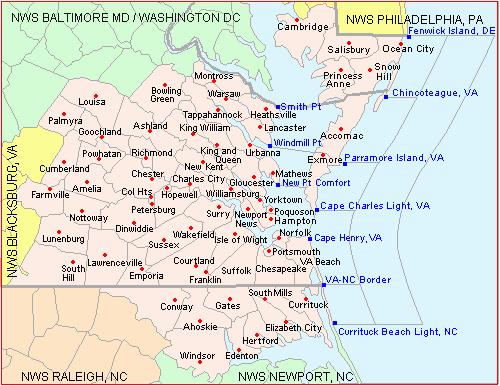
Decision Support Briefing 1 As of: 945AM EDT 8/28/2017. Wakefield, VA. What Has Changed?
|
|
|
- Jodie Lindsey
- 5 years ago
- Views:
Transcription


1 Decision Support Briefing 1 As of: 945AM EDT 8/28/ What Has Changed? Initial Issuance


2 Main Points Hazard Impacts Location Timing Wind Damage to weak structures, trees and power lines and possible power outages due to wind gusts of 50+ mph Tidewater/Coastal Eastern Shore/NE NC Tuesday into Tuesday Evening High Surf/Rip Currents Surf of 8 to 12 feet combined with a high risk of rip currents will create dangerous swimming conditions Entire shoreline of MD/VA/NE NC Tuesday into Tuesday Evening Coastal Flooding Water Level Rises of 2 to 3 feet above normal tide possible, causing moderate flooding. Hampton Roads Tuesday into Tuesday Evening Flooding Rain Urban Areas, small creeks and streams, low lying areas and roads Tidewater and NE NC Late Monday Night into Tuesday Evening Marine Wind gusts 45 to 50 knots with seas to up to 13 feet will make it dangerous for even large ships All Coastal Waters and lower Chesapeake Bay Tuesday into Tuesday Night


3 Summary of Greatest Impacts: SE VA/NE NC/Lower MD Eastern Shore Wind: Gusts 50+ mph close to the shore/bay None Limited Elevated Significant Extreme High Surf/High Risk of Rip Currents None Limited Elevated Significant Extreme Coastal Flooding: Mainly Hampton Roads None Limited Elevated Significant Extreme Flooding: Localized Threat Tidewater/NE NC None Limited Elevated Significant Extreme Marine: Wind gusts 45 to 50 kts, Seas up to 13 ft None Limited Elevated Significant Extreme

4 High Wind Potential NE winds of 30 to 35 mph with gusts of 50 to 60 mph are expected across much of Coastal VA/Lower MD Eastern Shore and NE NC Tuesday into Tuesday Evening. These type of winds will cause downed trees and power lines, with some minor roof or structural damage.

5 Coastal Flooding Persistent and strengthening onshore flow will likely cause some minor to moderate coastal flooding during the high tide cycle Tuesday into Tuesday Night. Hampton Roads will have the greatest threat for coastal flooding with Sewells Point, Yorktown and Jamestown all expected to see moderate flooding.

6 Rain/Flooding Potential Storm Total Rainfall Monday Night Through Wednesday morning will range from an inch or less across the piedmont to 3 to 5 inches Coastal VA and NE NC. Localized Flooding of urban areas, creeks/streams, and low lying areas/roads is possible. A flood watch is in effect for all of the Tidewater and NE NC.


7 High Surf/Rip Current Potential Dangerous Surf of 7 to 10 feet and Rip Currents are expected Today into Tuesday. Swimming will be dangerous to anyone in the water. The wind combined with the surf will cause dangerous boating conditions as well and small craft are advised to remain in port.


8 Marine Threat Potential Strong NE winds of 30 to 40 kt with gusts of 45 to 50 kt are expected Tuesday into Tuesday Night. Seas of 8 to 12 feet over the coastal waters and 5 to 8 feet in the bay. The strongest winds will likely be over the coastal waters and lower Chesapeake Bay where storm force wind gusts are possible. Marine conditions will become dangerous due to the large waves and strong winds.
9 Event Summary Increasing threat for potential for wind gusts in excess of 50 mph Potential for limited urban and small stream flooding due to heavy rain late tonight into Tuesday. Dangerous Marine Conditions expected from high seas and gusts to near or slightly above storm force. Moderate coastal flooding with water levels 2 to 3 feet above normal tide levels, causing moderate impacts especially in the Hampton Roads area.


10 Contact and Next Briefing Information Next Briefing When: 5 pm EDT Monday Briefing Webpage: Briefing Available At: Web: Facebook: NWSWakefieldVA Phone (public): (757) Twitter: akq-report@noaa.gov YouTube: NWSWakefieldVA Disclaimer: The information contained within this briefing is time-sensitive, do not use after time month, date
HURRICANE NATE BRIEFING
 HURRICANE NATE BRIEFING 5:00 AM CDT Saturday, October 7, 2017 Prepared by: NWS NWSNewOrleans www.weather.gov/neworleans Situation Overview Nate is now a hurricane with no significant change in the track
HURRICANE NATE BRIEFING
 HURRICANE NATE BRIEFING 11:00 PM CDT Friday, October 6, 2017 Prepared by: NWS NWSNewOrleans www.weather.gov/neworleans Situation Overview Nate is now a hurricane with no significant change in the track
Unit 11 Lesson 2 How Does Ocean Water Move? Copyright Houghton Mifflin Harcourt Publishing Company
 Unit 11 Lesson 2 How Does Ocean Water Move? Catch a Wave A wave is the up-and-down movement of surface water. Catch a Wave Catch a Wave (wave effects) Surface waves are caused by wind pushing against
NOAA/NWS Forecasting and observing of Great Lakes Rip Currents
 NOAA/NWS Forecasting and observing of Great Lakes Rip Currents Great Lakes Rip Current Conference June 3, 2009 Dave Guenther WFO Marquette Where we have been: Research in the hazard of rip currents began
Florida Division of Emergency Management State Watch Office
 Florida Division of Emergency Management State Watch Office Morning Situation Report Saturday, October 13, 2018 State Emergency Operations Center Activation Level Level 1 Activation SERT On-Call Personnel
Tsunamis. Tsunamis COMMUNITY EMERGENCY RESPONSE TEAM TSUNAMIS
 Tsunamis Tsunamis Tell the participants that tsunamis are ocean waves that are produced by underwater earthquakes or landslides. The word is Japanese and means harbor wave because of the devastating effects
Florida Division of Emergency Management State Watch Office
 Florida Division of Emergency Management State Watch Office Morning Situation Report Saturday, February 9, 2019 State Emergency Operations Center Activation Level Level 3 Monitoring SERT On-Call Personnel
Sea Level Rise and Coastal Flooding Why Waves Matter!
 Sea Level Rise and Coastal Flooding Why Waves Matter! Jason D. Burtner Massachusetts Office of Coastal Zone Management South Shore Regional Coordinator Sea Level Rise and Coastal Storm Damage and Flooding
Florida Division of Emergency Management State Watch Office
 Florida Division of Emergency Management State Watch Office Morning Situation Report Thursday, October 18, 2018 State Emergency Operations Center Activation Level Level 1 Activation SERT On-Call Personnel
Warm-up # 7 A day 5/17 - B day 5/18 UPDATE YOUR TABLE OF CONTENTS
 Warm-up # 7 A day 5/17 - B day 5/18 UPDATE YOUR TABLE OF CONTENTS Question: List all examples of surface water on Earth. Answer: Rivers and streams, lakes and reservoirs, (ponds) wetlands, estuaries and
G. Meadows, H. Purcell and L. Meadows University of Michigan
 www.coj.net/departments/fire+and+rescue/emergency+preparedness/rip+current.htm G. Meadows, H. Purcell and L. Meadows Over 80% of all surf related rescues are attributable to Rip Currents According to the
NYS Coastal Waters. Water Resources of NYS: THE NATURE of the COASTAL ZONE. NYS Coastal Waters. NYS Coastal Atlas. Coastal Zone Management 10/10/2014
 Water Resources of NYS: THE NATURE of the COASTAL ZONE NYS Coastal Waters NYS is the only state to border the Atlantic Ocean and the Great Lakes (Lakes Erie and Ontario). Great Lakes shoreline: 577 miles
MARSH DEGRADATION AT THE MOUTH OF MOORE CREEK
 MARSH DEGRADATION AT THE MOUTH OF MOORE CREEK Hunter Winstanley, Department of Earth Sciences, University of South Alabama, Mobile, AL 36688. E-Mail: hcw501@jaguar1.usouthal.edu. Moore Creek is located
Only launch your boat once you have a clear understanding of the most up-to-date weather forecast.
 Weather and Tides Observing the Weather Only launch your boat once you have a clear understanding of the most up-to-date weather forecast. Start with television and newspaper weather map reports; they
Tsunami Preparedness in the Capital Region
 Tsunami Preparedness in the Capital Region A presentation by: the CRD Local Government Emergency Program Advisory Commission (LG EPAC) and your community emergency programs What is a tsunami? A tsunami
Pathogen Transport in Coastal Environments: Case Studies of Urban Runoff in Southern California
 Pathogen Transport in Coastal Environments: Case Studies of Urban Runoff in Southern California A presentation to the Center for Water Sciences MSU Pathogens Workshop, April 20, 2007 Stanley B. Grant Henry
Yorktown Beach with Hurricane Isabel Impacts
 Yorktown Beach 3-5 with Hurricane Isabel Impacts VIMS Shoreline Studies Program January 5 Yorktown Beach 3-5 with Hurricane Isabel Impacts Donna A. Milligan C. Scott Hardaway, Jr. Linda M. Meneghini George
Tsunami Preparedness in the Capital Region
 Tsunami Preparedness in the Capital Region A presentation by: the CRD Local Government Emergency Program Advisory Commission (LG EPAC) and your community emergency programs What is a tsunami? A tsunami
Impact of Hurricane Matthew on the Atlantic Coast of Florida
 Impact of Hurricane Matthew on the Atlantic Coast of Florida A coastal engineer was driving across country and his jeep broke down in front of a monastery. It was late in the day and the monks invited
VENICE LOCAL COASTAL PROGRAM UPDATE: COASTAL HAZARDS WELCOME
 VENICE LOCAL COASTAL PROGRAM UPDATE: COASTAL HAZARDS WELCOME 1 Introducing the Team Hosted by the Department of City Planning and grant funded in part by the California Coastal Commission 2 Workshop Purpose
3/6/2001 Fig. 6-1, p.142
 First GOES 11 image http://visible earth.nasa.g ov/view_rec. php?id=190 Air-born dust from the Sahara Desert, Feb. 2001 Fig. 6-CO, p.140 dust from China over Japan. 3/5/2001 FIGURE 6.1 A model of the atmosphere
MONITORING SEDIMENT TRANSPORT PROCESSES AT MANAVGAT RIVER MOUTH, ANTALYA TURKEY
 COPEDEC VI, 2003 in Colombo, Sri Lanka MONITORING SEDIMENT TRANSPORT PROCESSES AT MANAVGAT RIVER MOUTH, ANTALYA TURKEY Isikhan GULER 1, Aysen ERGIN 2, Ahmet Cevdet YALCINER 3 ABSTRACT Manavgat River, where
Atmospheric Circulation (Ch. 8) Ocean & Atmosphere are intertwined Gases & waters freely exchanged Wind Weather Climate
 Ocean & Atmosphere are intertwined Gases & waters freely exchanged Wind Weather Climate") Atmospheric Circulation (Ch. 8) Ocean & Atmosphere are intertwined Gases & waters freely exchanged Wind Weather Climate Atmospheric Structure Consists of Layers Separated by Temperature Stratosphere: Temperature
Atmospheric Circulation (Ch. 8) Ocean & Atmosphere are intertwined Gases & waters freely exchanged Wind Weather Climate Atmospheric Structure Consists of Layers Separated by Temperature Stratosphere: Temperature
HURRICANE SANDY LIMITED REEVALUATION REPORT UNION BEACH, NEW JERSEY DRAFT ENGINEERING APPENDIX SUB APPENDIX D SBEACH MODELING
 HURRICANE SANDY LIMITED REEVALUATION REPORT UNION BEACH, NEW JERSEY DRAFT ENGINEERING APPENDIX SUB APPENDIX D SBEACH MODELING Rev. 18 Feb 2015 1 SBEACH Modeling 1.0 Introduction Following the methodology
Chapter 10 Lecture Outline. The Restless Oceans
 Chapter 10 Lecture Outline The Restless Oceans Focus Question 10.1 How does the Coriolis effect influence ocean currents? The Ocean s Surface Circulation Ocean currents Masses of water that flow from one
Marine Ecosystems. Aquatic Ecosystems Section 2
 Marine Ecosystems Marine ecosystems are located mainly in coastal areas and in the open ocean. Organisms that live in coastal areas adapt to changes in water level and salinity. Organisms that live in
Historical Analysis of Montañita, Ecuador for April 6-14 and March 16-24
 Historical Analysis of Montañita, Ecuador for April 6-14 and March 16-24 Prepared for the ISA by Mark Willis and the Surfline Forecast and Science Teams Figure 1. Perfect Right- hander at Montañita, Ecuador
ALTERNATIVES FOR COASTAL STORM DAMAGE MITIGATION
 ALTERNATIVES FOR COASTAL STORM DAMAGE MITIGATION Dave Basco Old Dominion University, Norfolk, Virginia, USA National Park Service Photo STRUCTURAL (changes to natural, physical system) hardening (seawalls,
Catch The SEACOOS Wave!
 Catch The SEACOOS Wave! Lundie Spence, Terri Hathaway, Margaret Olsen, Maia McGuire, Carrie Thomas, Jennifer Jolly Clair Presentation National Marine Educators Association July 20, 2004 Why are we interested
Weather questions. Question 1 (1 Mark) State what information is included in a cyclone warning.
 State what information is included in a cyclone warning.") Question 1 (1 Mark) Weather questions State what information is included in a cyclone warning. Question 2 (1 Mark) In which direction do winds travel around a high pressure system in the southern hemisphere?
Question 1 (1 Mark) Weather questions State what information is included in a cyclone warning. Question 2 (1 Mark) In which direction do winds travel around a high pressure system in the southern hemisphere?
3/9/2013. Build house on cliff for a view of the ocean - be one with said view Pearson Education, Inc. Shorelines: summary in haiku form
 Introduction to Environmental Geology, 5e Edward A. Keller Shorelines: summary in haiku form Chapter 11 Coastal Processes Lecture Presentation prepared by X. Mara Chen, Salisbury University Build house
City of Del Mar Local Coastal Plan (LCP) Amendment for Sea Level Rise and Coastal Flooding
 Amendment for Sea Level Rise and Coastal Flooding") City of Del Mar Local Coastal Plan (LCP) Amendment for Sea Level Rise and Coastal Flooding 6/22/17 Presentation to Sea Level Rise Stakeholder- Technical Advisory Committee (STAC) Nick Garrity, P.E. Lindsey
City of Del Mar Local Coastal Plan (LCP) Amendment for Sea Level Rise and Coastal Flooding 6/22/17 Presentation to Sea Level Rise Stakeholder- Technical Advisory Committee (STAC) Nick Garrity, P.E. Lindsey
Local Winds & Microclimates. Unit 2- Module 1
 Local Winds & Microclimates Unit 2- Module 1 Objectives Overview of local winds (sea & land breezes, valley winds) Overview of microclimates (valley, urban, woodland) Local Winds Local Winds Local winds
OFFICE OF STRUCTURES MANUAL FOR HYDROLOGIC AND HYDRAULIC DESIGN CHAPTER 11 APPENDIX B TIDEROUT 2 USERS MANUAL
 OFFICE OF STRUCTURES MANUAL FOR HYDROLOGIC AND HYDRAULIC DESIGN CHAPTER 11 APPENDIX B TIDEROUT 2 USERS MANUAL APRIL 2011 APRIL 2011 Page 1 Preface TIDEROUT 2, Build 1.22 dated June 29, 2006 is the current
Taranaki Tsunami Inundation Analysis. Prepared for Taranaki Civil Defence Emergency Management Group. Final Version
 Taranaki Tsunami Inundation Analysis Prepared for Taranaki Civil Defence Emergency Management Group Final Version June 2012 AM 12/07 HBRC Plan Number 4362 Asset Management Group Technical Report Prepared
Marginal Marine Environments
 Marginal Marine Environments Delta: discrete shoreline protuberances formed where rivers enter oceans, semi-enclosed seas, lakes or lagoons and supply sediment more rapidly than it can be redistributed
consulting engineers and scientists
 consulting engineers and scientists Coastal Processes Presented by: January 9, 2015 Varoujan Hagopian, P.E. F.ASCE Senior Consultant, Waterfront Engineer Living Shoreline Workshop Lets Remember Why We
The Value of Created Dunes to address Coastal Hazards in Chesapeake Bay: Hurricane Isabel Impacts
 The Value of Created Dunes to address Coastal Hazards in Chesapeake Bay: Hurricane Isabel Impacts November 2000 NL42, 14 Oct 2003 The Value of Created Dunes to address Coastal Hazards in Chesapeake Bay:
If you have a badge logo I d center it to this text. Douglas F. Jackson. Fire Chief / Emergency Management Director East Haven, CT
 If you have a badge logo I d center it to this text Douglas F. Jackson Fire Chief / Emergency Management Director East Haven, CT Experience 9YEARS Experience as Fire Chief Emergency Management Director
Table 4. Volumetric Change Rates Pre-Project and Post-Project for the Town of Duck
 V. VOLUMETRIC CHANGES General Volumetric changes measured over the entire monitoring area for various time periods are provided in Table 4. The volume changes are given in terms of cubic yards/foot of
UNDERSTANDING STORM SURGE
 The Education Program at the New Jersey Sea Grant Consortium 22 Magruder Road, Fort Hancock, NJ 07732 (732) 872-1300 www.njseagrant.org UNDERSTANDING STORM SURGE ACTIVITY 6 SURGE OF THE STORM http://secoora.org/classroom/virtual_hurricane/surge_of_the_storm>
Dune Monitoring Data Update Summary: 2013
 Dune Monitoring Data Update Summary: 13 Shoreline Studies Program Virginia Institute of Marine Science College of William & Mary Gloucester Point, Virginia September 13 Dune Monitoring Data Update Summary:
Coastal management has lagged behind the growth in population leading to problems with pollution
 Fifty percent of the population of the industrialized world lives within 100 km of a coast. Coastal management has lagged behind the growth in population leading to problems with pollution and natural
Future Condi,ons coastal hazard modeling and mapping
 Future Condi,ons coastal hazard modeling and mapping Presented by Bob Ba:alio, PE Environmental Science Associates, Inc. (ESA) On behalf of the physical processes team (USGS, TerraCosta- Scripps, ESA)
The Surge of the Storm By Margaret Olsen and Katie Greganti
 The Surge of the Storm By Margaret Olsen and Katie Greganti Grade Level: 5-12 Type of Activity: Hands on Focus Question: How does a hurricane s storm surge of a hurricane affect the low-lying areas along
Port Stephens Council
 Port Stephens ouncil State of the eaches 22 23 Overall results Percentage of sites graded as Good or Good: 9 Nine of the eleven swimming sites were graded as Good or Good in 22 23, a fall in performance
Estuarine Shoreline Stabilization
 Estuarine Shoreline Stabilization Property Owner s Guide to Determining the Most Appropriate Stabilization Method Estuarine shorelines are dynamic features that experience continued erosion. Land is lost
Environmental Definitions and Deployment Guidance for Instructors, Coaches and Leaders
 Environmental s and Deployment Guidance for Instructors, Coaches and Leaders This document provides guidance and environmental definitions that can be applied when choosing paddlesport activity. British
Chagrin River TMDL Appendices. Appendix F
 Appendix F The following are excerpts from the Eastern Brook Trout Joint Venture s Conservation Strategy (Working Draft v.6), Conserving the Eastern Brook Trout: Strategies for Action Found at: http://www.easternbrooktrout.org/constrategy.html
Atmospheric Circulation. Density of Air. Density of Air: H 2 O and Pressure effects
 Today s topics: Atmospheric circulation: generation of wind patterns on a rotating Earth Seasonal patterns of climate: Monsoons and Sea Breezes Tropical Cyclones: Hurricanes and typhoons Atmospheric Circulation
Shoreline Erosion and Proposed Control at Experimental Facility 15 Spesutie Island
 ARL-SR-0383 SEP 2017 US Army Research Laboratory Shoreline Erosion and Proposed Control at Experimental Facility 15 Spesutie Island by Todd Brinkman NOTICES Disclaimers The findings in this report are
instructors official training aid APPROVED TRAINING AID
 instructors official training aid WIND WINDOW FIGURE OF EIGHT Power Zone Flying the kite in a figure of eight is how you generate power WIND DIRECTION Off Shore Cross Off Shore Cross Off Shore Cross Shore
Introduction to Storm Surge
 Introduction to Storm Surge Hurricane Katrina (2005) Mississippi 1200 deaths, $108 billion damage Hurricane Sandy (2012) Northeast U.S. 73 deaths, $65 billion damage Hurricane Ike (2008) - Bolivar Peninsula,
Rip Current Rip Tide,
 Rip Current A Rip Current, sometimes called a Rip Tide, is one specific kind of water current that can be found near beaches. It is a strong, localized, narrow current of water. It is strongest near the
Emergency Action Plans
 Emergency Action Plans Emergency Action Plan E.A.P. Definition A course of action that is to be undertaken by a coach when an emergency / incident occurs during a surfing session. Emergency Action Plan
Pure Adventure Ltd Risk Assessment
 Pure Adventure Ltd Risk Assessment Activity / Exercise: Surfing, Stand-up Paddle Boarding (SUP) Location: St BRELADE S BAY 1. Drowning Students / Coach Controlled activity by qualified person (International
Hydrologic Feasibility of Storm Surge Barriers
 Hydrologic Feasibility of Storm Surge Barriers Malcolm J. Bowman, School of Marine and Atmospheric Sciences State University of New York, Stony Brook, NY. Presented at Against the Deluge: Storm Surge Barriers
ALTERNATIVES FOR COASTAL STORM DAMAGE MITIGATION AND FUNCTIONAL DESIGN OF COASTAL STRUCTURES
 The University of the West Indies Organization of American States PROFESSIONAL DEVELOPMENT PROGRAMME: COASTAL INFRASTRUCTURE DESIGN, CONSTRUCTION AND MAINTENANCE A COURSE IN COASTAL DEFENSE SYSTEMS I CHAPTER
Oceans and Coasts. Chapter 18
 Oceans and Coasts Chapter 18 Exploring the oceans The ocean floor Sediments thicken and the age of the seafloor increases from ridge to shore The continental shelf off the northeast United States Constituent
WIND IN KNOTS, WAVE HEIGHTS IN METERS. NO SEA STATE GIVEN IF WAVES LESS THAN 3M.
 DATE ISSUED: 14/08/2015 FORECAST VALID FROM 132200 TO 142200 UTC: IN KNOTS, WAVE HEIGHTS IN METERS. NO SEA STATE GIVEN IF WAVES LESS THAN 3M. GALE WARNINGS: ============== 1 / 13 1. TRISTAN: SW 35 in the
Habitat Fact Sheets. Rocky habitats are dominated by seaweeds and often mussels, which rely on the rocks for attachment.
 Habitat Fact Sheets Habitats in the Gulf of Maine serve many important roles for the environment and for humans as well. These include: cycling nutrients, filtering pollution, trapping sediments, storing
Port of Port Elizabeth Information
 LOCATION Latitude 34º 01 S Longitude 25º 42 E PILOTAGE Pilotage is compulsory. Rendezvous point is 2.2 nautical miles NE of the port entrance on the leading lights. Pilot transfer is by pilot boat, unless
OCEAN WAVES NAME. I. Introduction
 NAME OCEAN WAVES I. Introduction The physical definition of a wave is a disturbance that transmits energy from one place to another. In the open ocean waves are formed when wis blowing across the water
Town of Duck, North Carolina
 Tracking No. 00.00.2010 Erosion Mitigation And Shoreline Management Feasibility Study Town of Duck, North Carolina Coastal Planning & Engineering of North Carolina February 28, 2013 Ken Willson 1 Tracking
2016 NC Coastal Local Governments Annual Meeting
 2016 NC Coastal Local Governments Annual Meeting Coastal Flood Study Modeling and Mapping 101 April 21, 2016 Tom Langan, PE, CFM Engineering Supervisor NCEM Floodplain Mapping Program FEMA Coastal Flood
CROSS-SHORE SEDIMENT PROCESSES
 The University of the West Indies Organization of American States PROFESSIONAL DEVELOPMENT PROGRAMME: COASTAL INFRASTRUCTURE DESIGN, CONSTRUCTION AND MAINTENANCE A COURSE IN COASTAL DEFENSE SYSTEMS I CHAPTER
D) water having a higher specific heat than land B) B C) expansion, cooling to the dewpoint, and condesation
 water having a higher specific heat than land B) B C) expansion, cooling to the dewpoint, and condesation") Base your answers to questions 1 through 4 on the map and the passage below and on your knowledge of Earth science. The map shows four different locations in India, labeled, A, B, C, and D, where vertical
Base your answers to questions 1 through 4 on the map and the passage below and on your knowledge of Earth science. The map shows four different locations in India, labeled, A, B, C, and D, where vertical
Synoptic Lab, MET 421, Test 2
 Name Synoptic Lab, MET 421, Test 2 1) For a 15 ms -1 east wind blowing towards Milwaukee a) Calculate the distance to the east shore of Lake Michigan. You can use a distance calculator website such as
The Storm Surge Hazard 2018 TS-8 Tropical Meteorology 2
 The Storm Surge Hazard 2018 TS-8 Tropical Meteorology 2 Daniel Noah National Weather Service Tampa Bay daniel.noah@noaa.gov Tropical Cyclone Storm Surge Is a large dome of water, often 50 to 100 miles
The Wind-Speed Dose-Response of Tree-Falls Impacting the Transmission Grid of Southwest British Columbia
 The Wind-Speed Dose-Response of Tree-Falls Impacting the Transmission Grid of Southwest British Columbia Wolf Read PhD Candidate Forest Science University of British Columbia Introduction Talk Outline:
LITTLE LAGOON & LITTLE LAGOON PASS: RESEARCH UPDATES & DIRECTIONS
 LITTLE LAGOON & LITTLE LAGOON PASS: RESEARCH UPDATES & DIRECTIONS Bret M. Webb, PhD, PE, DCE Professor Department of Civil, Coastal, and Environmental Engineering October 19, 2017 LLPS Meeting Acknowledgments
MINISTRY OF TOURISM GUIDELINES FOR KITESURFING ACTIVITIES
 MINISTRY OF TOURISM GUIDELINES FOR KITESURFING ACTIVITIES 1. Purpose of the Guidelines The guidelines aim at ensuring that kitesurfing activities are conducted in compliance with acceptable standards and
Figure 4, Photo mosaic taken on February 14 about an hour before sunset near low tide.
 The Impact on Great South Bay of the Breach at Old Inlet Charles N. Flagg and Roger Flood School of Marine and Atmospheric Sciences, Stony Brook University Since the last report was issued on January 31
The Case of the Disappearing Shoreline
 Name The Case of the Disappearing Shoreline Humans change the earth's climate in many ways. One change is the increase of carbon dioxide in the atmosphere. As we burn more fossil fuels, we release more
There are many different kinds of beaches which are generally characterized by the dominance of waves, tides, rivers and currents, and in particular
 Fig. 11-11, p. 253 There are many different kinds of beaches which are generally characterized by the dominance of waves, tides, rivers and currents, and in particular differ by the amount of energy, which
Beach Profiles. Topics. Module 9b Beach Profiles and Crossshore Sediment Transport 3/23/2016. CE A676 Coastal Engineering
 Beach Profiles AND CROSS-SHORE TRANSPORT Orson P. Smith, PE, Ph.D., Professor Emeritus Topics Features of beach and nearshore profiles Equilibrium profiles Cross-shore transport References Text (Sorensen)
CASE STUDY 1: GRANTHAM AND LOCKYER VALLEY FLOODS 2011
 CASE STUDY 1: GRANTHAM AND LOCKYER VALLEY FLOODS 2011 On 9th and 10th of January 2011, heavy rainfall caused flash flooding to occur across parts of Queensland resulting in widespread damage to property
Sussex County, DE Preliminary Study Overview
 Sussex County, DE Preliminary Study Overview Coastal study scope: 102 miles of entire County shoreline Revised 102 panels for coastal study Riverine study scope: 14 streams, 67.1 miles, within the Nanticoke
The Wet and Wild Winter of in west Cornwall
 DECEMBER 2013 The Wet and Wild Winter of 2013-2014 in west Cornwall It all started so benignly, then after a lovely sunny day with light winds on the 16 th, the unsettled, very wet and sometimes stormy
SteerCert Objective. Detailed knowledge of Contents of key selected rules from ColRegs and PLA Byelaws Contents of Tideway Rowing Rules
 SteerCert Objective Detailed knowledge of Contents of key selected rules from ColRegs and PLA Byelaws Contents of Tideway Rowing Rules Knowledge of Right of way Signals Bridge passing guidelines Overtaking
LAKKOPETRA (GREECE) EUROSION Case Study. Contact: Kyriakos SPYROPOULOS. TRITON Consulting Engineers. 90 Pratinou Str Athens (GREECE)
 EUROSION Case Study. Contact: Kyriakos SPYROPOULOS. TRITON Consulting Engineers. 90 Pratinou Str Athens (GREECE)") LAKKOPETRA (GREECE) Contact: Kyriakos SPYROPOULOS TRITON Consulting Engineers 90 Pratinou Str. 11634 Athens (GREECE) Tel: +32 10 729 57 61 Fax: +32 10 724 33 58 e-mail: kspyropoulos@tritonsa.gr 19 1 1.
LAKKOPETRA (GREECE) Contact: Kyriakos SPYROPOULOS TRITON Consulting Engineers 90 Pratinou Str. 11634 Athens (GREECE) Tel: +32 10 729 57 61 Fax: +32 10 724 33 58 e-mail: kspyropoulos@tritonsa.gr 19 1 1.
Climate Change and Security:
 Climate Change and Security: Ideas & Inspiration from Annapolis Angela Schedel, CDR, U.S. Navy Assistant Professor, U.S. Naval Academy Presented on September 13, 2016 at USFSP icar Workshop Disclaimer
Wind vs. Water Presented by:
 Wind vs. Water Presented by: Michael D. Spensieri, P.E. Regional Engineering Manager Office: 800-482-5611, Ext: 2018 www.donan.com Michael D. Spensieri, P.E. B.S.C.E. from West Virginia University Presenter
DAILY FLOOD SHEET (Imperial) Manitoba Lakes Highest Recorded Peak Flood
 Manitoba Lakes Highest Recorded Peak Flood") Hydrologic Forecasting and Water Management, Infrastructure & Transportation August 1, 2014 LOCATION Today's Change from (ft) of Forecasted eak DAILY FLOOD SHEET (Imperial) s est Recorded eak Flood Desirable
Hydrologic Forecasting and Water Management, Infrastructure & Transportation August 1, 2014 LOCATION Today's Change from (ft) of Forecasted eak DAILY FLOOD SHEET (Imperial) s est Recorded eak Flood Desirable
Reading Material. Inshore oceanography, Anikouchine and Sternberg The World Ocean, Prentice-Hall
 Reading Material Inshore oceanography, Anikouchine and Sternberg The World Ocean, Prentice-Hall BEACH PROCESSES AND COASTAL ENVIRONMENTS COASTAL FEATURES Cross section Map view Terminology for Coastal
Lecture Outlines PowerPoint. Chapter 15 Earth Science, 12e Tarbuck/Lutgens
 Lecture Outlines PowerPoint Chapter 15 Earth Science, 12e Tarbuck/Lutgens 2009 Pearson Prentice Hall This work is protected by United States copyright laws and is provided solely for the use of instructors
VIRGINIA BEACH. The perfect. of work and. play play. play
 VIRGINIA BEACH The perfect balance of work and play play play best place to live in america. -USA Today Weekend boston newark new york cleveland philadelphia pittsburgh baltimore washington, d.c. virginia
History of the Tallebudgera Beach Outdoor Education School
 DIARY ANSWERS History of the Tallebudgera Beach Outdoor Education School P4 Access the Beach School website to complete this page: www.thebeachschool.eq.edu.au About Our School > History of our School
Inventory of coastal sandy areas protection of infrastructure and planned retreat
 2018-02-28 Inventory of coastal sandy areas protection of infrastructure and planned retreat Johanna Birgander, Thorbjörn Nilsson, Pär Persson Summary To estimate the natural protection around the coast
Shorelines Earth - Chapter 20 Stan Hatfield Southwestern Illinois College
 Shorelines Earth - Chapter 20 Stan Hatfield Southwestern Illinois College The Shoreline A Dynamic Interface The shoreline is a dynamic interface (common boundary) among air, land, and the ocean. The shoreline
Design Criteria Data
 MEMPHIS TN Latitude = 35.35 N WMO No. 723345 Longitude = 89.87 W Elevation = 322 feet Period of Record = 1973 to 1996 Average Pressure = 29.68 inches Hg Design Criteria Data Mean Coincident (Average) Values
Design Criteria Data
 FRESNO CA Latitude = 36.77 N WMO No. 72389 Longitude =119.7 W Elevation = 328 feet Period of Record = 1972 to 1996 Average Pressure = 29.62 inches Hg Design Criteria Data Mean Coincident (Average) Values
Risk Assessment. Compiled by: Lawrence Smith Date Compiled: 1 February 2009
 Risk Assessment Compiled by: Lawrence Smith Date Compiled: 1 February 2009 Location: Gwithian Date of Activity: Ongoing Activity: Kitesurfing on the sea and launching and landing of LEI kites on land.
Alan Bravey Humber Local Resilience Forum. Tidal Surge Lessons to be Learned, 5 December 2013
 Alan Bravey Humber Local Resilience Forum Tidal Surge Lessons to be Learned, 5 December 2013 What is a tidal surge? Atlantic depression tracks into North Sea Very strong winds (pushes sea water into a
APPENDIX H LAKE OKEECHOBEE FLOOD ROUTINES
 1 2 3 APPENDIX H LAKE OKEECHOBEE FLOOD ROUTINES 1 2 3 4 5 6 7 8 9 10 11 12 13 14 15 16 17 18 19 20 21 22 23 24 25 26 27 28 29 30 31 32 33 34 35 36 37 38 39 40 41 42 43 44 45 LAKE OKEECHOBEE FLOOD ROUTINGS
Design Criteria Data
 TUCUMCARI NM Latitude = 35.18 N WMO No. 723676 Longitude =13.6 W Elevation = 465 feet Period of Record = 1973 to 1996 Average Pressure = 25.86 inches Hg Design Criteria Data Mean Coincident (Average) Values
SUPPLEMENTAL DOCUMENT SEA LEVEL RISE SCENARIO SELECTION AND DESIGN TIDE CALCULATION
 SUPPLEMENTAL DOCUMENT SEA LEVEL RISE SCENARIO SELECTION AND DESIGN TIDE CALCULATION FOR THE GUIDANCE FOR INCORPORATING SEA LEVEL RISE INTO CAPITAL PLANNING IN SAN FRANCISCO: ASSESSING VULNERABILITY AND
Natural Bridges Field Trip Activity
 Natural Bridges Field Trip Activity This is due in class on MONDAY- March 1 - not in sections! Name TA: NOTE ON THE GRADING OF THIS ASSIGNMENT: Many of the questions below (especially in the tidepool part)
ST LEONARDS COASTAL HAZARD VULNERABILITY ASSESSMENT
 Level 12, 333 Collins Street Melbourne VIC 3000 Australia Telephone: +61 3 8676 3500 Facsimile: +61 3 8676 3505 www.worleyparsons.com WorleyParsons Services Pty Ltd ABN 61 001 279 812 23 November 2011
What causes the tides in the ocean?
 What causes the tides in the ocean? By NASA and NOAA, adapted by Newsela staff on 02.09.17 Word Count 769 Level 970L Flying gulls on Morro Strand State Beach, California, at low tide. Morro Rock is seen