Alan Bravey Humber Local Resilience Forum. Tidal Surge Lessons to be Learned, 5 December 2013
|
|
|
- Calvin Page
- 5 years ago
- Views:
Transcription
1 Alan Bravey Humber Local Resilience Forum Tidal Surge Lessons to be Learned, 5 December 2013
")
2 What is a tidal surge? Atlantic depression tracks into North Sea Very strong winds (pushes sea water into a dome) Very low atmospheric pressure (allows sea water to rise) North Sea shallow


3 Causes a single tidal surge down the East Coast
4 When combined with high spring tides can lead to: Overtopping Potential breaching of defences Plus gale conditions and flooding associated with poor weather (surface water, river etc)
5 General Time Line Tuesday am ResCG Teleconference Tuesday pm Humber LRF FAS Teleconference Wednesday am Humber LRF TCG Telecon in response to Amber FGS Wednesday pm ResCG Teleconference Wednesday pm precautionary TCG Thursday am precautionary TCG Thursday am SGC SCG / TCG operating through to Friday afternoon
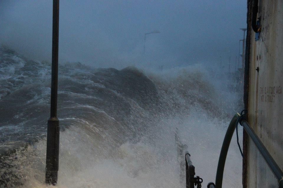
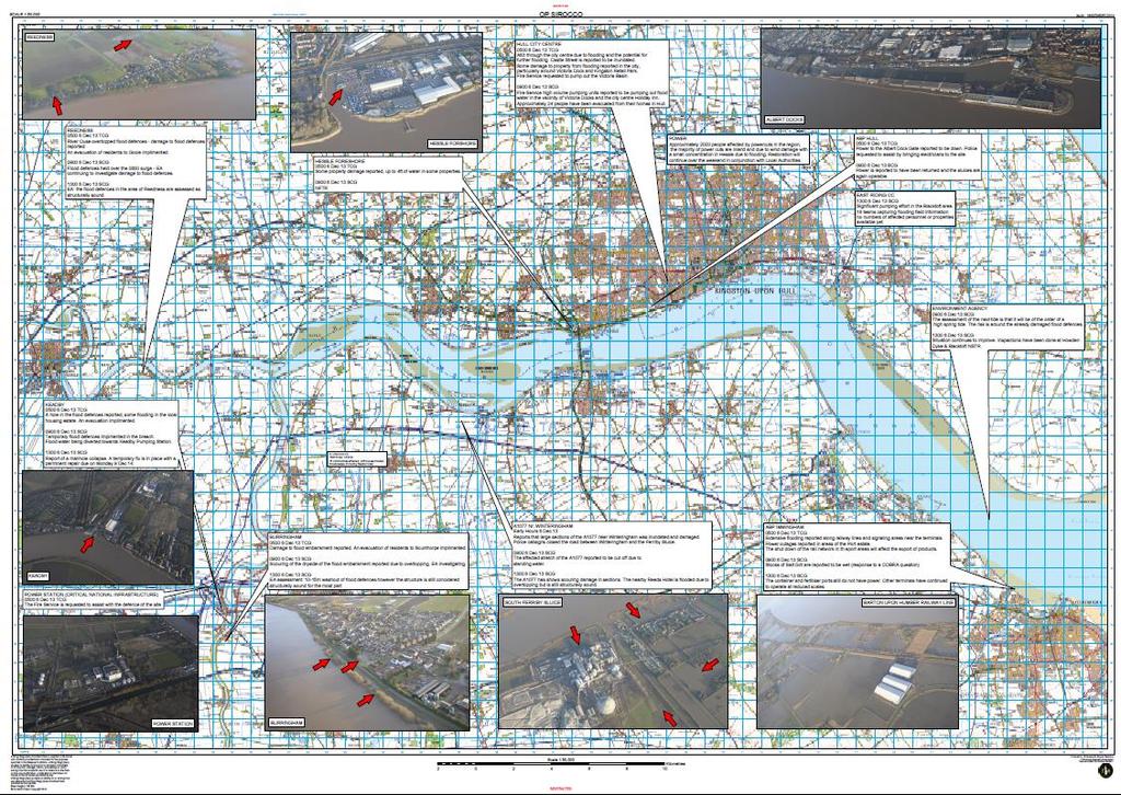
6 Bridlington Harbour
7

8 South Ferriby

9 South Ferriby
10

11 Undermined / missing flood defences
12
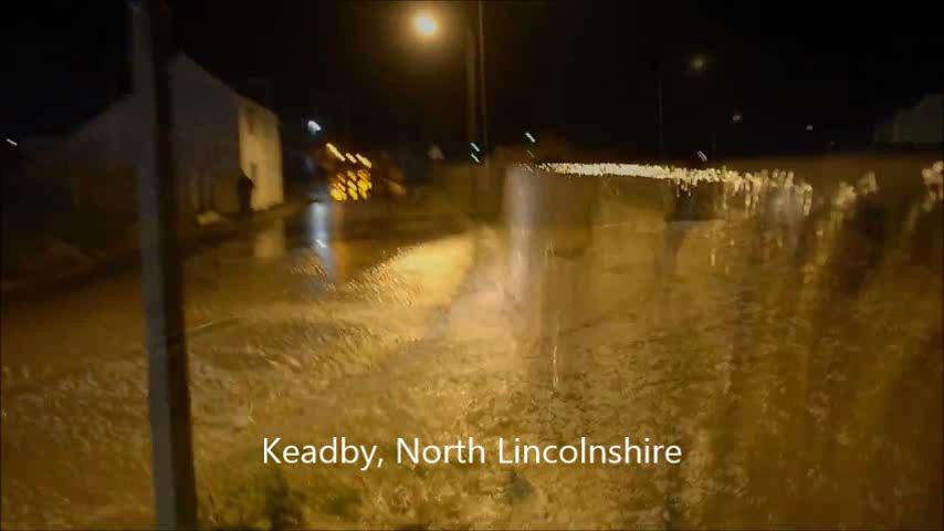
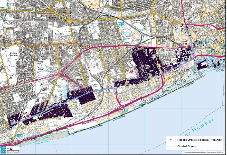
13 Properties Affected East Riding of Yorkshire 192 residential, 148 commercial Hull City 149 residential, 118 commercial North East Lincolnshire no known flooding North Lincolnshire 348 residential and commercial
14 Some lessons learned Overall, the multi-agency response and recovery to the emergency were considered to have worked well
15 Tidal surges are a difficult thing to predict!
16 Over simplification of our Monday High tides understanding Tuesday Normal winter weather Wednesday North Bank good chance of flooding / South Bank not particularly at risk. Not a H19 type tidal inundation. Thursday South Bank (Grimsby / Clee) at most risk. Hull at no risk.


17 Some of the Flood Guidance Statements Thursday confidence high, specific locations uncertain. Which tide would be

18 Difficult to predict extent of surge Tide 400 mm higher than expected at Newcastle bigger than expected 2 hours till it reaches the Humber what does that mean? Flood warnings issued with minutes notice

19 Impact in the Humber very unpredictable
20 Pre-deploying assets in specific locations very difficult (although general alert allowed Fire to successfully request national resources) therefore pre-deploy anyway at coastal locations. From Tuesday risk is Yellow low confidence of medium impact. Is Amber the right trigger?
21 Flood Advisory Service Telecon Worked well partners fully briefed on latest information. Determined the the need TCG Who has signed up to the FAS in your LRF area?
22 Trigger Level Problem Half of our area at Amber and half at Yellow. Changed to Amber during precautionary TCG meeting.

23 Convening TCG / SCG Early stand up worked well. How do you repeat that? SMS alert imperative Teleconference option essential, but not ideal Not all partners could be represented by either route

24 Flood Warnings Lots and lots of flood warnings issued in very quick succession! Wish we had used the live map! First ever Severe Flood Warning

25 Flood Warnings Feeling from residents they were not warned of the risk of flooding Flood Sirens in Grimsby / Cleethorpes caused little reaction

26 The ResCG Who represents your LRF when a ResCG is called before a SCG has been convened? Does the ResCG replace any local telecons? Who has the most accurate info Local or National? Should you prioritise the ResCG during the response? What is the value of the ResCG?

27 Hours before high tide. Who withdraws their staff? Who has shut down their assets and resources? How safe are the spotters?

28 How easy is it to talk to: COMAH sites? CNI sites? Parish Councils? Elected Members? MPs? Cat 1 and 2 responders not present at SCG / TCG? A neighbouring SCG?

29 Coastal Erosion Risk
30 Communicating with Media Widespread media coverage until Nelson Mandella announcement Extensive and excellent coverage on local BBC Press conference held, lots of interviews..
31 Social Media, Websites Thousands of web hits, large use of Facebook, reasonable use of Twitter. Thousands of extra people following Press teams just about managed to keep on top of social media enquiries

32 Communicating with Media Could have been more joined up Better engagement with Cat 2 s One team approach proposed for future

33 Boat Assets Some convergent boats used to rescue Outside of Command and Control Structure How can F&RS coordinate?
34 Evacuation How to we know when to encourage vertical evacuation? How do we know how bad it will be, and where we can locate our rest centres? Are Rest Centres open before a Severe Flood Warning issued? How effective are the business continuity arrangements of social landlords? How effectively is location of rest centres shared at TCG? Supporting Station operators with Rest Centres?
35 Community Emergency Plans Excellent response from communities usually regardless of whether they had a plan or not Most without plan felt they would like to have one Some plans out of date
36 Recovery Recovery started Friday morning, most initial recovery activities finished by Monday. Key lesson do it quicker! Recovery was not particularly multi agency

37 Multi Agency Flood Plan A little unwieldy Call for a Flooding STAC Can Cat 2 s make their assets more resilient?
38 In Summary Advanced warning, TCG and SCG in place before key tides Excellent multi agency working massive challenges dealt with effectively Could have been much worse with on shore winds. Many of the lessons learned focussed on whether we can improve forecasting
39 Thanks for listening any questions?
Tsunami Preparedness in the Capital Region
 Tsunami Preparedness in the Capital Region A presentation by: the CRD Local Government Emergency Program Advisory Commission (LG EPAC) and your community emergency programs What is a tsunami? A tsunami
Tsunami Preparedness in the Capital Region
 Tsunami Preparedness in the Capital Region A presentation by: the CRD Local Government Emergency Program Advisory Commission (LG EPAC) and your community emergency programs What is a tsunami? A tsunami
LOCAL COASTAL PROGRAM UPDATE
 LOCAL COASTAL PROGRAM UPDATE Agenda Meeting #1 General Information (1 1:45 pm) Introductions and Background Grants involved What is a Local Coastal Program? What is required? LCP Update tasks and schedule
TSUNAMI WARNINGS - A GUIDE FOR MEDIA - August 2018
 TSUNAMI WARNINGS - A GUIDE FOR MEDIA - August 2018 Tsunami that affect New Zealand may be generated on, near, or far from our shores. New Zealand is at risk from tsunami that happen near us, and around
THE INEVITABLE RIPPLE 2ND OF APRIL TSUNAMI
 THE INEVITABLE RIPPLE 2ND OF APRIL TSUNAMI Structure Background Preparedness for 2nd of April Response Operations 2nd of April Lessons learnt Future work Hawaii 1957 Background Approx 250,000 people live
City of Del Mar Local Coastal Plan (LCP) Amendment for Sea Level Rise and Coastal Flooding
 Amendment for Sea Level Rise and Coastal Flooding") City of Del Mar Local Coastal Plan (LCP) Amendment for Sea Level Rise and Coastal Flooding 6/22/17 Presentation to Sea Level Rise Stakeholder- Technical Advisory Committee (STAC) Nick Garrity, P.E. Lindsey
City of Del Mar Local Coastal Plan (LCP) Amendment for Sea Level Rise and Coastal Flooding 6/22/17 Presentation to Sea Level Rise Stakeholder- Technical Advisory Committee (STAC) Nick Garrity, P.E. Lindsey
The frequently asked questions are grouped under headings to make it easier to find information -
 Tsunami Inundation Mapping for Hawke s Bay Frequently Asked Questions The frequently asked questions are grouped under headings to make it easier to find information - General tsunami information Tsunami
Assessing Tidal Flood Risk in Ireland: Modelling, Mapping & Forecasting Coastal and Tidal Flood Risk for Irish APSFRs
 Assessing Tidal Flood Risk in Ireland: Modelling, Mapping & Forecasting Coastal and Tidal Flood Risk for Irish APSFRs Dr. John Martin C.Eng. OPW Flood Risk Assessment & Management Section, Ireland WG-F
Taranaki Tsunami Inundation Analysis. Prepared for Taranaki Civil Defence Emergency Management Group. Final Version
 Taranaki Tsunami Inundation Analysis Prepared for Taranaki Civil Defence Emergency Management Group Final Version June 2012 AM 12/07 HBRC Plan Number 4362 Asset Management Group Technical Report Prepared
Unit 11 Lesson 2 How Does Ocean Water Move? Copyright Houghton Mifflin Harcourt Publishing Company
 Unit 11 Lesson 2 How Does Ocean Water Move? Catch a Wave A wave is the up-and-down movement of surface water. Catch a Wave Catch a Wave (wave effects) Surface waves are caused by wind pushing against
Coastal Inundation. An Overview for TCDC
 Coastal Inundation An Overview for TCDC Rick Liefting Team Leader Regional Hazards and Environmental Compliance Integrated Catchment Management Waikato Regional Council Photo: Sugar Loaf Wharf, Coromandel.
WHAT IS A TSUNAMI? happens.nz. Long or Strong GET GONE TSUNAMI 101
 WHAT IS A TSUNAMI? A tsunami is a series of powerful waves with strong currents. They are mostly caused by underwater or coastal earthquakes, and sometimes by underwater landslides or volcanic eruptions.
APPENDIX H PLUME MODELS
 APPENDIX H PLUME MODELS APPENDIX H PLUME MODELS Prior to the initiation of recovery activities, the National Oceanic and Atmospheric Administration ran a series of oil plume trajectory analyses (2001a)
Coastal Hazards Study
 Coastal Hazards Study 2212 Beach Boulevard, Pacifica Prepared for: EXECUTIVE SUMMARY City of Pacifica 170 Santa Maria Ave Pacifica, CA 94044 Prepared by: moffatt & nichol 2185 N. California Blvd. Walnut
Reducing regional flood and erosion risk from wave action on the Channel Coast
 Reducing regional flood and erosion risk from wave action on the Channel Coast Jack Eade, Channel Coastal Observatory Travis Mason, Channel Coastal Observatory Uwe Dornbusch, Environment Agency Tim Pullen,
Case study 64. Shoreham Harbour Shingle Bypassing and Recycling
 Case study 64. Shoreham Harbour Shingle Bypassing and Recycling Authors: Tony Parker, Uwe Dornbusch Main driver: Improved defences Project stage: Ongoing construction/operation since 1992 Photo 1: Shoreham
Emergency Action Plans for Dam Safety
 Emergency Action Plans for Dam Safety Introduction to the NC EAP template Tami Idol, EI Assistant State Dam Safety Engineer Reduce risk to loss of life Determine emergency level Make notifications for
consulting engineers and scientists
 consulting engineers and scientists Coastal Processes Presented by: January 9, 2015 Varoujan Hagopian, P.E. F.ASCE Senior Consultant, Waterfront Engineer Living Shoreline Workshop Lets Remember Why We
Only launch your boat once you have a clear understanding of the most up-to-date weather forecast.
 Weather and Tides Observing the Weather Only launch your boat once you have a clear understanding of the most up-to-date weather forecast. Start with television and newspaper weather map reports; they
Safer Roads Humber Annual Safety Camera Progress Report April 2010 March 2011
 Safer Roads Humber Annual Safety Camera Progress Report April 2010 March 2011 www.saferroadshumber.com Published March 2012 CONTENTS Safer Roads Humber Camera Performance Summary... 1 Safer Roads Humber
Boothbay Harbor Rotary Club May 12, 2016
 Mapping Potential Sea Level Rise and Storm Surge in Boothbay Harbor, ME Boothbay Harbor Rotary Club May 12, 2016 Peter A. Slovinsky, Marine Geologist Maine Geological Survey S.M. Dickson, MGS Quickly,
Tsunamis. Tsunamis COMMUNITY EMERGENCY RESPONSE TEAM TSUNAMIS
 Tsunamis Tsunamis Tell the participants that tsunamis are ocean waves that are produced by underwater earthquakes or landslides. The word is Japanese and means harbor wave because of the devastating effects
NORTHERN CELL OPTIONS SHORTLIST RECOMMENDATIONS
 OPTIONS SHORTLIST RECOMMENDATIONS Coastal Unit C: Bayview Options recommended for MCDA scoring. Status quo. Planting 3. Renourishment (gravel) 6. Beach-scraping 7. Restore shingle crest. Inundation accommodation
Draft Coastal Zone Management Plan for Byron Shire Coastline
 Byron Shire Council Draft Coastal Zone Management Plan for Byron Shire Coastline 26 November 2010 #1030842 Presentation Outline o o o o o o o Brief Byron Shire erosion history What is a CZMP? Why Develop
HURRICANE NATE BRIEFING
 HURRICANE NATE BRIEFING 5:00 AM CDT Saturday, October 7, 2017 Prepared by: NWS NWSNewOrleans www.weather.gov/neworleans Situation Overview Nate is now a hurricane with no significant change in the track
PCSO Barnaby Prince Police Community Support Officer Mobile: (Alford)
") Issue: January 2014. MABLETHORPE & ALFORD Neighbourhood Policing Team Area Update Contact Details: PCSO Barnaby Prince Mobile: 07500920376 (Alford) barnaby.prince@lincs.pnn.police.uk Like Facebook? Find
Issue: January 2014. MABLETHORPE & ALFORD Neighbourhood Policing Team Area Update Contact Details: PCSO Barnaby Prince Mobile: 07500920376 (Alford) barnaby.prince@lincs.pnn.police.uk Like Facebook? Find
Llandudno Beach Management Plan and Options Appraisal
 Llandudno Beach Management Plan and Options Appraisal August, 2017 G.B. Edwards BEng (Hons) CEng FICE Head of, Mochdre Offices, Conway Road, Mochdre, Colwyn Bay, LL28 5AB. Tel. (01492) 574000 Fax. (01492)
Stakeholder Communication and Public Involvement Plan
 Stakeholder Communication and Public Involvement Plan Arkansas Statewide Bicycle and Pedestrian Transportation Plan Plan purpose: The Arkansas State Bicycle and Pedestrian Plan will establish a framework
BETWEEN A ROCK AND A HARD PLACE
 BETWEEN A ROCK AND A HARD PLACE Mike Newman Ocean-image.com Options for protecting Penzance and Newlyn from the effects of Climate Change It s not just the predicted 1 metre rise in sea level and the increased
NORTH COUNTY FIRE AUTHORITY POLICY & PROCEDURE MANUAL OPERATIONS
 PURPOSE: When responding to reported debris flows, fire personnel must take into consideration tactical priorities of Life Safety, Incident Stabilization, and Property Conservation. POLICY: Personnel safety
CASE STUDY 1: GRANTHAM AND LOCKYER VALLEY FLOODS 2011
 CASE STUDY 1: GRANTHAM AND LOCKYER VALLEY FLOODS 2011 On 9th and 10th of January 2011, heavy rainfall caused flash flooding to occur across parts of Queensland resulting in widespread damage to property
Leaning Into Adaptation
 www.marinslr.org Leaning Into Adaptation GFNMS Ocean Summit, May 17, 2016 Jack Liebster, Planning Manager, Marin County Marin County C-SMART Sea Level Rise Adaptation Process Evaluate Science Info. Implement
CHAPTER 8 ASSESSMENT OF COASTAL VULNERABILITY INDEX
 124 CHAPTER 8 ASSESSMENT OF COASTAL VULNERABILITY INDEX 8.1 INTRODUCTION In order to assess the vulnerability of the shoreline considered under this study against the changing environmental conditions,
Coastal Flood Events and Potential Habitat Loss on the Suffolk Coast
 Coastal Flood Events and Potential Habitat Loss on the Suffolk Coast With the availability of projected flood zones for specific scaled tidal flood events and remotely sensed habitat mapping it is possible
INTRODUCTION TO COASTAL ENGINEERING
 The University of the West Indies Organization of American States PROFESSIONAL DEVELOPMENT PROGRAMME: COASTAL INFRASTRUCTURE DESIGN, CONSTRUCTION AND MAINTENANCE A COURSE IN COASTAL DEFENSE SYSTEMS I CHAPTER
GONE! Coastal Erosion Happens During Storms! Why Worry About Coastal Setbacks? Goals for Today
 RI Regulatory Setbacks & Buffers: Coastal Zone Management Issues New England Onsite Wastewater Training Program @ URI OWT 155 November 21, 2013 Goals for Today Understand the impacts of storms, coastal
The Storm Surge Hazard 2018 TS-8 Tropical Meteorology 2
 The Storm Surge Hazard 2018 TS-8 Tropical Meteorology 2 Daniel Noah National Weather Service Tampa Bay daniel.noah@noaa.gov Tropical Cyclone Storm Surge Is a large dome of water, often 50 to 100 miles
Municipal Adaptation to Sea Level Rise in Saco Bay, Ogunquit, and Seabrook
 Municipal Adaptation to Sea Level Rise in Saco Bay, Ogunquit, and Seabrook Changing Environments Symposium Bowdoin College October 24, 2009 Climate Change Adaptation Panel 1:45 to 3:00 PM Jonathan T. Lockman,
Sea Level Rise and Coastal Flooding Why Waves Matter!
 Sea Level Rise and Coastal Flooding Why Waves Matter! Jason D. Burtner Massachusetts Office of Coastal Zone Management South Shore Regional Coordinator Sea Level Rise and Coastal Storm Damage and Flooding
Patrol Captain liases with WSS and alerts Surfcom. Missing Body Arms Crossed In water. Keep everyone on beach
 Policy To From Subject : Lost submerged Patient for Nippers and General Public : Nippers, PC s Board Of Management : Life Saving Committee : Evacuation and Lost/Submerge Patient Version : 5 Date : 7 September
Tyne LDS and Tyne United SBH. 28 October Safety Plan draft as at (separate versions for LDS and SBH may be produced at next stage)
") Tyne LDS and Tyne United SBH 28 October 2017 Safety Plan draft as at 14-07-17 (separate versions for LDS and SBH may be produced at next stage) This document should be read in conjunction with the event
Tyne LDS and Tyne United SBH 28 October 2017 Safety Plan draft as at 14-07-17 (separate versions for LDS and SBH may be produced at next stage) This document should be read in conjunction with the event
Sea Kayak Leader Assessment Notes
 Sea Kayak Leader Assessment Notes Technical Syllabus Part A Personal Paddling Skills If the paddler s kayak is fitted with a rudder, it must be disabled for the duration of the assessment. The paddler
Texans Helping Texans TEXSAR TEXAS SEARCH & RESCUE
 Texans Helping Texans TEXSAR TEXAS SEARCH & RESCUE Search & Rescue - Flood & Swiftwater Rescue Wildland Fire - Incident Management - Medical Disaster Response - K9 Search - Aerial Search Who is TEXSAR?
SURGE SUPPRESSION ACHIEVED BY DIFFERENT COASTAL SPINE (IKE DIKE) ALIGNMENTS. Bruce A. Ebersole, Thomas W. Richardson and Robert W.
 ALIGNMENTS. Bruce A. Ebersole, Thomas W. Richardson and Robert W.") SURGE SUPPRESSION ACHIEVED BY DIFFERENT COASTAL SPINE (IKE DIKE) ALIGNMENTS Abstract Bruce A. Ebersole, Thomas W. Richardson and Robert W. Whalin, Jackson State University, Jackson, Mississippi The primary
SURGE SUPPRESSION ACHIEVED BY DIFFERENT COASTAL SPINE (IKE DIKE) ALIGNMENTS Abstract Bruce A. Ebersole, Thomas W. Richardson and Robert W. Whalin, Jackson State University, Jackson, Mississippi The primary
2 How do I use the Coastal Inundation Tool?
 Coastal Inundation Tool Guidance 1 Overview The Coastal Inundation Tool provides users with a tool to quickly understand the susceptibility of coastal areas to coastal inundation due to tides, storms and
RI Regulatory Setbacks & Buffers: Coastal Management Issues
 RI Regulatory Setbacks & Buffers: Coastal Management Issues New England Onsite Wastewater Training Program @ URI OWT 155 - November 29, 2012 James Boyd - Coastal Policy Analyst Photo: October 30, 2012
Safe Speed programme ATTACHMENT 1. Randhir Karma, Group Manager Network Management and Safety
 Safe Speed programme ATTACHMENT 1 Randhir Karma, Group Manager Network Management and Safety 1 Why Safe Speeds? AT s strategic context National guidance AT has embraced Vision Zero principles and recognises
World Championship Expression of Interest
 International Moth Class Association World Championship Expression of Interest Issued March 1 2014 Submission due June 30 2014 1 Contents 2 Preliminary... 4 General... 5 Venue... 5 Travel and accommodation...
HURRICANE NATE BRIEFING
 HURRICANE NATE BRIEFING 11:00 PM CDT Friday, October 6, 2017 Prepared by: NWS NWSNewOrleans www.weather.gov/neworleans Situation Overview Nate is now a hurricane with no significant change in the track
PUBLIC EXHIBITION OF COASTAL ZONE MANAGEMENT PLAN FOR COLLAROY-NARRABEEN BEACH AND FISHERMANS BEACH
 ITEM 8.3 REPORTING MANAGER TRIM FILE REF 2014/110936 ATTACHMENTS PUBLIC EXHIBITION OF COASTAL ZONE MANAGEMENT PLAN FOR COLLAROY-NARRABEEN BEACH AND FISHERMANS BEACH GROUP MANAGER NATURAL ENVIRONMENT 1
Flood Rescue National Enhancement Project
 www.defra.gov.uk Flood Rescue National Enhancement Project Issued by Defra Department for Environment, Food and Rural Affairs Nobel House 17 Smith Square London SW1P 3JR Telephone 020 7238 6000 Website:
DELAWARE S VULNERABLE COASTAL AREAS. DELAWARE INLAND BAYS and DELAWARE BAY RECONNAISSANCE STUDY
 DELAWARE S VULNERABLE COASTAL AREAS and the DELAWARE INLAND BAYS and DELAWARE BAY RECONNAISSANCE STUDY Kimberly K. McKenna, PG Delaware Dept. of Natural Resources & Environmental Control Division of Watershed
Appendix 12 Consequences
 Appendix 12 Consequences Overview All of the consequence data used in the risk analysis was provided by the IPET Consequence team whose work is reported in Volume VII of the IPET report. The following
SAN MATEO COUNTY SEA LEVEL RISE INITIATIVE
 SAN MATEO COUNTY SEA LEVEL RISE INITIATIVE OCEAN CLIMATE SUMMIT // MAY 17, 2016 Photo by Biking Nikon SF, all rights reserved San Mateo County has $24 billion in assets at risk from sea level rise Pacifica
Baraga County, MI Coastal Hazard Analysis Flood Risk Review Meeting. July 12, 2018
 Baraga County, MI Coastal Hazard Analysis Flood Risk Review Meeting July 12, 2018 Agenda Introductions Coastal Flood Risk Study and Mapping Program Current Status Technical Overview of Study and Mapping
The Surge of the Storm By Margaret Olsen and Katie Greganti
 The Surge of the Storm By Margaret Olsen and Katie Greganti Grade Level: 5-12 Type of Activity: Hands on Focus Question: How does a hurricane s storm surge of a hurricane affect the low-lying areas along
MIRG Seminar Mass Rescue Operations. David Jardine-Smith International Maritime Rescue Federation
 MIRG Seminar 2016 Mass Rescue Operations David Jardine-Smith International Maritime Rescue Federation The International Maritime Rescue Federation Our purpose The IMRF brings the world's maritime SAR organisations
Lessons learnt from the Samoa tsunami September a multi-disciplinary survey
 Lessons learnt from the Samoa tsunami September 2009 - a multi-disciplinary survey Stefan Reese, Jochen Bind, Graeme Smart, Shona van Zijll de Jong, William Power, Brendon Bradley, Kate Wilson, Gegar Prasetya
Decision Support Briefing 1 As of: 945AM EDT 8/28/2017. Wakefield, VA. What Has Changed?
 Decision Support Briefing 1 As of: 945AM EDT 8/28/2017 http://www.weather.gov/akq/--- What Has Changed? Initial Issuance Main Points Hazard Impacts Location Timing Wind Damage to weak structures, trees
Name Class Date. Use the terms from the following list to complete the sentences below. Each term may be used only once. Some terms may not be used.
 Assessment Chapter Test B The Movement of Ocean Water USING KEY TERMS Use the terms from the following list to complete the sentences below. Each term may be used only once. Some terms may not be used.
The Highways Agency is working to improve the M1 between junction 28 (near Alfreton) and junction 35a (the A616 Stocksbridge bypass).
 and junction 35a (the A616 Stocksbridge bypass).") Welcome The Highways Agency is working to improve the M1 between junction 28 (near Alfreton) and junction 35a (the A616 Stocksbridge bypass). The M1 is a vital part of the strategic road network, connecting
Welcome The Highways Agency is working to improve the M1 between junction 28 (near Alfreton) and junction 35a (the A616 Stocksbridge bypass). The M1 is a vital part of the strategic road network, connecting
Figure 4, Photo mosaic taken on February 14 about an hour before sunset near low tide.
 The Impact on Great South Bay of the Breach at Old Inlet Charles N. Flagg and Roger Flood School of Marine and Atmospheric Sciences, Stony Brook University Since the last report was issued on January 31
COUPLED MANAGEMENT STRATEGY LAKE CATHIE ESTUARY & COAST
 Lake Cathie Progress Association Inc. ABN 28 251 433 854 P.O. Box 247 Lake Cathie NSW 2445 PHONE/FAX: 02 6584 8211 EMAIL: r3packag@bigpond.com 20 th October 2009 Port Macquarie Hastings Council PO Box
Instructions for Support Boat Duties
 Instructions for Support Boat Duties You must attend the Race day and safety briefing in the committee room ( usually at 8.45am) You should bring your own lifejacket with you as the club does not have
Notice of Competition Event Information Support Document 28 th February 2018 Rev 2
 Notice of Competition Event Information Support Document 28 th February 2018 Rev 2 1 Sprints - background Power8 Sprints will be an urban/city centre sprint rowing event series featuring elite men s and
Identifying Areas with Potential to Contain High Value Fish Habitat (HVFH) June 2007
 June 2007") Identifying Areas with Potential to Contain High Value Fish Habitat (HVFH) June 2007 1 High Value Fish Habitat INTENT: To apply added precautionary protection to those special areas deemed of high value
Identifying Areas with Potential to Contain High Value Fish Habitat (HVFH) June 2007 1 High Value Fish Habitat INTENT: To apply added precautionary protection to those special areas deemed of high value
St. Louis County, MN Coastal Hazard Analysis Flood Risk Review Meeting. May 2, 2018
 St. Louis County, MN Coastal Hazard Analysis Flood Risk Review Meeting May 2, 2018 Agenda Introductions Coastal Flood Risk Study and Mapping Program Current Status Technical Overview of Study and Mapping
Fortified For Safer Living
 Fortified For Safer Living Module 15: Protecting Homes Against Floods and Storm Surge An important part of trying to reduce the damage and losses from storm events is to make sure that the home doesn t
Operations & Safety Manual
 Operations & Safety Manual 2014 Lake George Open Water Swim 2.5k, 5k & 10k Open Water Swims Saturday, August 23, 2014 Hague Public Beach Hague, NY RACE PLAN The 2014 Lake George Open Water Swims consist
Intergovernmental Oceanographic Commission. International Tsunami Information Center
 W W W.T S U N A M I W AV E.I N F O Intergovernmental Oceanographic Commission INTERNATIONAL TSUNAMI INFORMATION CENTER International Tsunami Information Center United Nations Educational, Scientific and
3.1 TRAFFIC CALMING PROCESS SUMMARY
 SECTION 3 3.0 TRAFFIC CALMING 3.1 TRAFFIC CALMING PROCESS SUMMARY Traffic calming is a means in which to reduce speeds and minimize vehicular traffic on local neighborhood streets. Citizen involvement
Chiswell and Chesil Beach (to Wyke Narrows) 6a02 and 6a03 SUMMARY OF PREFERRED PLAN RECOMMENDATIONS AND JUSTIFICATION
 6a02 and 6a03 SUMMARY OF PREFERRED PLAN RECOMMENDATIONS AND JUSTIFICATION") Location reference: Policy Unit reference: Plan: Chiswell and Chesil Beach (to Wyke Narrows) 6a02 and 6a03 SUMMARY OF PREFERRED PLAN RECOMMENDATIONS AND JUSTIFICATION The long term aim for this section
Location reference: Policy Unit reference: Plan: Chiswell and Chesil Beach (to Wyke Narrows) 6a02 and 6a03 SUMMARY OF PREFERRED PLAN RECOMMENDATIONS AND JUSTIFICATION The long term aim for this section
Oceans in Motion: Waves and Tides
 Oceans in Motion: Waves and Tides Waves Waves are among the most familiar features in the ocean. All waves work similarly, so although we are talking about ocean waves here, the same information would
The Pillowcase Project Learn. Practice. Share.
 The Pillowcase Project Learn. Practice. Share. local hazard resource Tsunami Preparedness Learning Objectives Students will be able to explain what causes tsunamis and what happens during a tsunami. Students
Retford Half Marathon - Partnership Opportunities
 Retford Half Marathon - Partnership Opportunities - Retford Business Forum, Monday 7th December 2015 - David Corbett, Organiser and Race Director - Retford Half Marathon (Retford Athletic and Running Club)
Bayfield & Ashland Counties, WI Coastal Hazard Analysis Flood Risk Review Meeting. June 05, 2018
 Bayfield & Ashland Counties, WI Coastal Hazard Analysis Flood Risk Review Meeting June 05, 2018 Agenda Introductions Coastal Flood Risk Study and Mapping Program Current Status Technical Overview of Study
13. TIDES Tidal waters
 Water levels vary in tidal and non-tidal waters: sailors should be aware that the depths shown on the charts do not always represent the actual amount of water under the boat. 13.1 Tidal waters In tidal
BookletChart. Sand Key to Rebecca Shoal NOAA Chart A reduced-scale NOAA nautical chart for small boaters
 BookletChart Sand Key to Rebecca Shoal NOAA Chart 11439 A reduced-scale NOAA nautical chart for small boaters When possible, use the full-size NOAA chart for navigation. Published by the National Oceanic
Protection Group Providing Solutions. Developing Your Emergency Preparedness
 Protection Group Providing Solutions Developing Your Emergency Preparedness Emergency Preparedness and the Efficient, Effective Management of Incidents Introduction Based on the Wilton International site
Collaboration: Sea-level Marin Adaptation Response Team (C-SMART)
") Collaboration: Sea-level Marin Adaptation Response Team (C-SMART) Photo Credit : Lighthawk Aerial Community Development Agency 3501 Civic Center Drive, Rm. 308 San Rafael, CA 94903 415 4736269 T www.marinslr.org
Collaboration: Sea-level Marin Adaptation Response Team (C-SMART) Photo Credit : Lighthawk Aerial Community Development Agency 3501 Civic Center Drive, Rm. 308 San Rafael, CA 94903 415 4736269 T www.marinslr.org
Figure 1, Chart showing the location of the Breach at Old Inlet and sensors deployed in Great South Bay.
 The Impact on Great South Bay of the Breach at Old Inlet Charles N. Flagg and Roger Flood School of Marine and Atmospheric Sciences, Stony Brook University The Great South Bay project (http://po.msrc.sunysb.edu/gsb/)
DUKC Chart Overlay. Presentation to IHO TWL and DQ Working Groups Wollongong, March 2014
 DUKC Chart Overlay Presentation to IHO TWL and DQ Working Groups Wollongong, March 2014 Outline Who is OMC? DUKC description & methodology. DUKC Chart Overlay concept. Chart Overlay application example.
RISK ASSESSMENT -HEATS-
 Honda RYA Youth RIB Championship 2018 RISK ASSESSMENT -HEATS- Issued by Royal Yachting Association October 2017 Page 1 of 12 Risk Assessment Event Summary Event Honda RYA Youth RIB Championship Organising
Door County, WI Coastal Hazard Analysis Flood Risk Review Meeting. August 21, 2017
 Door County, WI Coastal Hazard Analysis Flood Risk Review Meeting August 21, 2017 Agenda Introductions Coastal Flood Risk Study and Mapping Program Current Status Technical Overview of Study and Mapping
APPENDIX D-2. Sea Level Rise Technical Memo
 APPENDIX D-2 Sea Level Rise Technical Memo 2185 N. California Blvd., Suite 500 Walnut Creek, CA 94596 (925) 944-5411 Fax: (925) 944-4732 www.moffattnichol.com DRAFT MEMORANDUM To: From: Neil Nichols,
FUTUREDMS 2018 CONSULTATION REPORT
 FUTUREDMS 2018 CONSULTATION REPORT Rev 1 17/08/2018 Sharing ideas of how to make amazing spaces and facilities better through the passion of talented people working together This document presents the
SUPPLEMENTAL DOCUMENT SEA LEVEL RISE SCENARIO SELECTION AND DESIGN TIDE CALCULATION
 SUPPLEMENTAL DOCUMENT SEA LEVEL RISE SCENARIO SELECTION AND DESIGN TIDE CALCULATION FOR THE GUIDANCE FOR INCORPORATING SEA LEVEL RISE INTO CAPITAL PLANNING IN SAN FRANCISCO: ASSESSING VULNERABILITY AND
SPO Regional Challenge Grant Creation of a Sea Level Adaption Working Group for Biddeford, Saco, OOB and Scarborough J.T. Lockman, AICP, Planning
 SPO Regional Challenge Grant Creation of a Sea Level Adaption Working Group for Biddeford, Saco, OOB and Scarborough J.T. Lockman, AICP, Planning Director Southern Maine Regional Planning Commission jlockman@smrpc.org
511 Public Information Materials for America s Cup Partners
 Joseph P. Bort MetroCenter 101 Eighth Street, Oakland, CA 94607-4700 511 Public Information Materials for America s Cup Partners Logo and Messaging Guidelines 2 Talking Points 4 Fact Sheet 5 Text for Partner
The Impact on Great South Bay of the Breach at Old Inlet Charles N. Flagg School of Marine and Atmospheric Sciences, Stony Brook University
 The Impact on Great South Bay of the Breach at Old Inlet Charles N. Flagg School of Marine and Atmospheric Sciences, Stony Brook University The previous report provided a detailed look at the conditions
Cycling Master Plan Community Engagement Session WELCOME
 Cycling Master Plan Community Engagement Session WELCOME WHY COMMUNITIES PLAN Considering Short Term and Long Term Needs City of Lethbridge is committed to planning - to determine short term goals along
UNDERSTANDING STORM SURGE
 The Education Program at the New Jersey Sea Grant Consortium 22 Magruder Road, Fort Hancock, NJ 07732 (732) 872-1300 www.njseagrant.org UNDERSTANDING STORM SURGE ACTIVITY 6 SURGE OF THE STORM http://secoora.org/classroom/virtual_hurricane/surge_of_the_storm>
CHAPTER 257 SEA LEVEL TRENDS IN THE HUMBER ESTUARY : A CASE STUDY PATRICK PARLE 1
 CHAPTER 257 SEA LEVEL TRENDS IN THE HUMBER ESTUARY : A CASE STUDY ABSTRACT PATRICK PARLE 1 In 1990 Posford Duvivier were commissioned by the National Rivers Authority to collect, audit and place on a database
M A R I N E C O R P S B A S E S H A W A I I C O M M U N I T Y B R I E F I N G O N T S U N A M I S 2 8 F E B
 M A R I N E C O R P S B A S E S H A W A I I C O M M U N I T Y B R I E F I N G O N T S U N A M I S 2 8 F E B 2 0 1 8 Briefer s JACQUELINE Rank FREELAND and Name INSTALLATION Briefer s PROTECTION Title/Office
storms and coastal defences at chiswell
 storms and coastal defences at chiswell What is this booklet about? This booklet provides information about: How Chesil Beach and the Fleet Lagoon formed and how it has changed over the last 100 years
The Eastern Coromandel Tsunami Strategy. Managing tsunami risks in Mercury Bay
 The Eastern Coromandel Tsunami Strategy Managing tsunami risks in Mercury Bay January 2017 Why are we working on the Eastern Coromandel Tsunami Strategy? The release of the Review of Tsunami Hazard in
NSW STATE STORM EMERGENCY SUB PLAN EMERGENCY PLANNING IN THE COASTAL ZONE
 NSW STATE STORM EMERGENCY SUB PLAN EMERGENCY PLANNING IN THE COASTAL ZONE November 2013 Cherie Parmenter 1, Nicholas Kuster 1, Belinda Davies 1 Phil Watson 2 1 NSW State Emergency Service (NSW SES) 2 NSW
Impact of Hurricane Matthew on the Atlantic Coast of Florida
 Impact of Hurricane Matthew on the Atlantic Coast of Florida A coastal engineer was driving across country and his jeep broke down in front of a monastery. It was late in the day and the monks invited
Water Rescue Boat Operation. Level: 3. Credit value: 6. Assessment criteria. Learning outcomes. The learner can: The learner will:
 Title: Water Rescue Boat Operation Level: 3 Credit value: 6 Learning outcomes The learner will: 1 understand the role of the rescue boat operator 2. understand the personal protective, communications and
WJEC Eduqas GCSE (9-1) Geography Mitigating Risk. (for assessment in 2019) Andy Owen
 Geography Mitigating Risk. (for assessment in 2019) Andy Owen") WJEC Eduqas GCSE (9-1) Geography Mitigating Risk (for assessment in 2019) Andy Owen An investigation of risk Your students need to investigate the concept that risks in our environment can be managed and
WJEC Eduqas GCSE (9-1) Geography Mitigating Risk (for assessment in 2019) Andy Owen An investigation of risk Your students need to investigate the concept that risks in our environment can be managed and