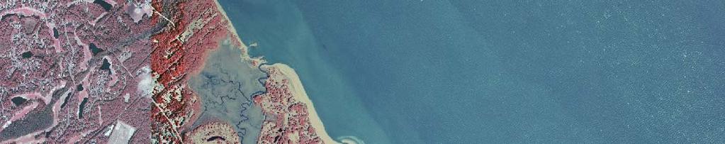
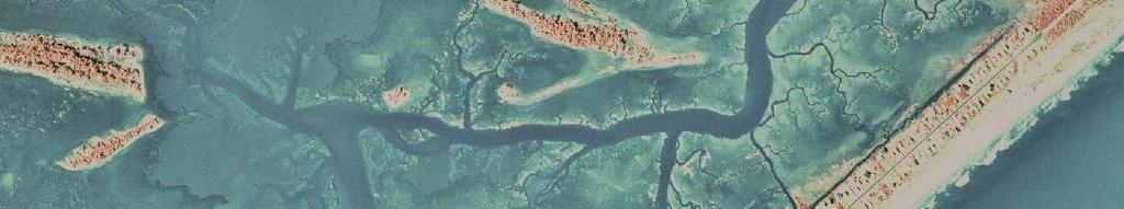
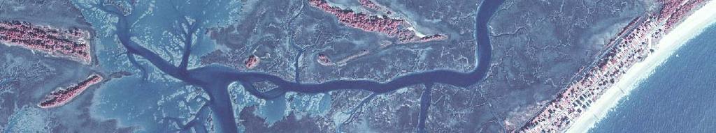
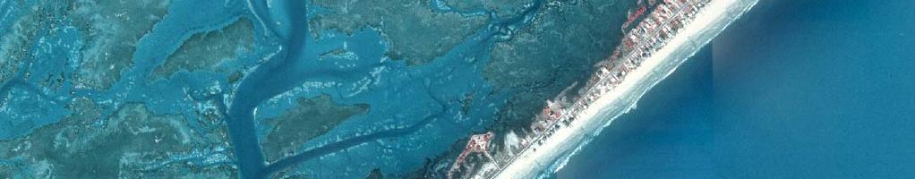
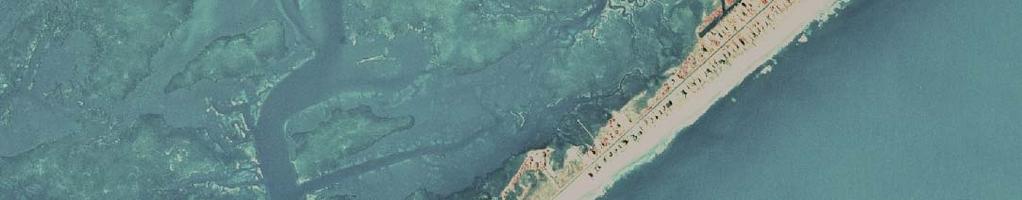
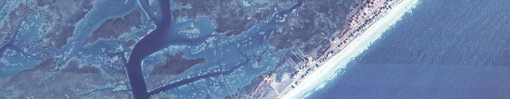
Cherry Grove Waties Island Island Myrtle Beach Pawleys Island Island
|
|
|
- Suzanna Butler
- 5 years ago
- Views:
Transcription
1 25 Yrs of Beachfront Management Act in South Carolina: Ebbs and Flows of the shoreline, structures and development Paul T. Gayes Center for Marine and Wetland Studies Coastal Carolina University NC Coastal Commission February 11, 2009 Beaufort, NC
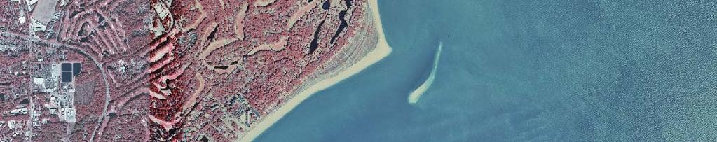
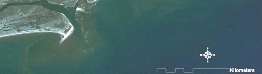
2 Large Range in Morphology and Dominant Processes Four Zones defined by morphology/processes and development


3 Cherry Grove / Waties Island Myrtle Beach Pawleys Island
4


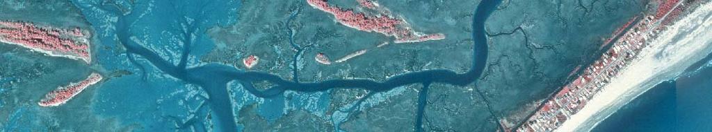
5 Santee Delta/ Cedar Island Bull Island Cape Romaine


6 Morris Island Folly Beach Edisto Island
7 Consider recent history at Cape Hatteras Charleston Harbor After Anders et al., 1995
8 Fripp Island Hunting Island
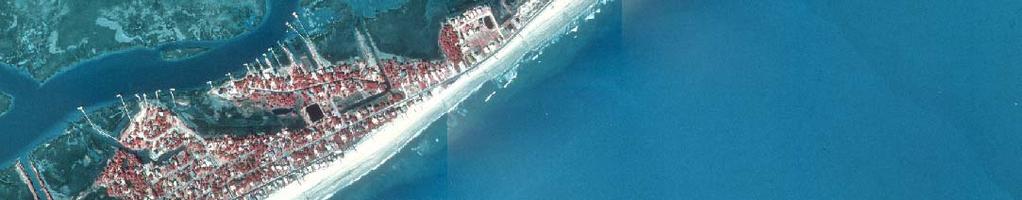
9 MB Pavilion Area 1929 Like Most tc Coastal lst States t South thc Carolina Has Developed Increasingly Massive and Static Infrastructure Advancing Towards a Migrating Shoreline


10 South Carolina Coastal Zone Management Myrtle Beach 1992 Limited jurisdiction Critical line set at the scarp line, or at the landward toe of the primary dune No jurisdiction landward of this line Seawalls routinely permitted Courtesy of Bill Eiser SC OCRM
11 A Significant Percentage of the South Carolina Coast Remains Undeveloped
12 Distribution of Groins in SC
13 Distribution of Groins Seawalls Seawalls Bulkheads Revetments Riprap Riprap in SC
14 1987 South Carolina Blue Ribbon Committee on Beachfront Management Appointed by Coastal Council in members: gov t, private, academic Asked to propose long-term solutions to beach erosion issues; balance public/private interests Found ~ 57 miles critically eroding Recommended changes to the 1977 SC Coastal Tidelands and Wetlands Act 1988 Beachfront Management Act
15 1987 South Carolina Blue Ribbon Committee on Beachfront Management Consensus on threats to: Beach/dune existence Life and property Tourism industry/coastal economy Coastal/marine habitats Findings of Fact: Sea level rise scientifically documented, and may increase Armoring has not proven effective Retreat is best long-term strategy
16 1988 Beachfront Management Act (BMA) Implemented recommendations of the Blue Ribbon Committee Created two new lines of jurisdiction Baseline methodology for standard zones (natural and armored), and inlet zones (stabilized and unstabilized) Setback line dependent on erosion rate


17 Landward most position of the shoreline in 40 yrs Eroded vegetation line on aerial photos INLET HAZARD ZONES Crest of the Primary Dune Defined Beach Surveys Shore parallel contours STANDARD ZONES OCRM 2000 Baseline OCRM 2000 Baseline


 3")
")


18 Armored / Developed Shorelines Washout Area Folly Beach, SC (1996) 3 years after nourishment) DeBordieu Beach, SC (2006) Renourished 2006 Pawleys Island, SC (2006) renourished 1998
19 2000 OCRM Baseline Ideal Dune Crest Jurisdictional Line Based on Volume and Morphology Rather Than a Shoreline
20 Baseline updated every 10 yrs. Long Term = Retreat Policy Set Back StB kli Line 40 x annual erosion rate Base Line

21 1988 BMA Restrictions No construction seaward of the baseline No new seawalls Eiti Existing seawalls, if destroyed, d could be replaced with sloping structures 10 from the building foundation All vertical seawalls to be removed after 30 years, and replaced with sloping structures


22 Hurricane Hugo, 1989 Initial Challenges Natural Many destroyed houses rebuilt farther landward, d bhidth behind the baseline (Urban/suburban renewal) Destroyed seawalls replaced with sloping structures 10 from building foundation
23 1989 Lucas Lawsuit Early Legal Challenges Lucas lots were totally seaward of the baseline, unbuildable under 1988 BMA Lucas sued, claiming a taking Case went to US Supreme Court, which ruled in his favor in 1992 and remanded the case for damages
24 1990 Revisions to BMA Construction seaward of the baseline could now be authorized under a special permit No larger than largest, never >5,000 s.f. Asfar landwardas as practical, no farther seaward than neighboring houses Never on primary dune or active beach No seawall as part of foundation If the house is ever located on the active beach, it must be removed* Destroyed seawalls could not be rebuilt DBR threshold at80% in 1990, 66 2/3% in 1995, 50% in year eartime limiton vertical walls allseliminated


25 1992 Lucas Lawsuit Resolution Lucas Lot While courts were determining damages, settled out of court State issued 2 special permits to Lucas State purchased lots for $425k each, plus $725k awarded ($1.575M total) State sold lots, transferred permits Lots were built on in 1995 and 1998
26 South Carolina State Policy Remains Essentially a Retreat Policy Some tightening Seawall Provision Some Loosening Special Permit In Practice Implementation and Associated Thorny Issues Delayed by Extensive Beach Nourishment. Mid term Solution to Long Term Issue 2005 Folly Beach Renourishment
27 South Carolina Beach Nourishment Area Year Length Cost Sand Volume (miles) (cubic yards) Seabrook Island $1,500, ,000 Debidue Beach $1,000, ,000 Hilton Head Island $10,000,000 2,000,000 Hunting Island $2,900, , Folly Beach $15,000,000 2,500,000 Edisto Beach $1,500, ,000 Grand Strand $54,000,000 5,000,000 Hilton Head Island $11,000,000 2,000,000 Sullivans Island $200,000 35,000 Debidue Beach $1,500, ,000 Pawleys Island $1,200, ,000 Daufuskie Island $6,000,000 1,400, Sea Pines-HHI $1,200, ,000 Folly Beach $12,500,000 2,300,000 Debidue Beach $5,600, ,000 Edisto Beach $8,000, ,000 Hunting Island $4,300, ,000 Hilton Head Island $19,000,000 2,700,000 Folly Beach $7,500, ,000 Grand Strand $40,700, ,900, Isle of Palms $9,900, ,00 21 Projects $194,150,000 27,700,000
28 At Present In South Carolina.Existing groins may be reconstructed, repaired, andmaintained maintained. New groins may only be allowed on beaches that have high erosion rates with erosion threatening existing development or public parks. (this is an issue for us emergency orders etc.)
29 In addition to these requirements, new groins may be constructed ntr td and existing itin groins rin may be reconstructed ntr td only in furtherance of an on-going beach renourishment effort which meets the criteria set forth in R.30-14(G), and in accordance with the following: ()Th (a) The applicant shall hlli institute i a monitoring i program for the life of the project to measure beach profiles along the groin area and adjacent and downdrift beach areas sufficient to determine erosion/accretion rates. For the first five years of the project, the monitoring program must include, but is not necessarily limited to: (i) establishment of new monuments; (ii) determination of the annual volume and transport of sand; and (iii) annual aerial photographs. p Subsequent monitoring requirements must be based on results from the first five-year report.
30 (b) Groins may only be permitted after thorough analysis demonstrates that the groin will not cause a detrimental effect on adjacent/downdriftdowndrift areas. The applicant shall provide a financially binding commitment, such as a performance bond or letter of credit that is reasonably estimated to cover the cost of reconstructing or removing the groin and/or restoring the affected beach through renourishment pursuant to subsection (c). (c) If the monitoring program established pursuant to subsection (a) shows an increased erosion rate along adjacent or downdrift beaches that is attributable to a groin, the department must require either that the groin be reconfigured so that the erosion rate on the affected beach does not exceed the pre-construction rate, that the groin be removed, and/or that the beach adversely affected by the groin be restored through renourishment.
31 (d) Adjacent and downdrift communities and municipalities must be notified by the department of all applications for a groin project. (e) An adjacent or downdrift property owner that claims a groin has caused or is causing an adverse impact shall notify the department of such impact. The department shall render an initial determination within sixty (60) days of such notification. Final agency action shall be rendered within twelve months of notification. An aggrieved party may appeal the decision pursuant to the Administrative Procedures Act.
32 (f) In an area in which new groins have been permitted, or in an area in which existing gg groins have been reconstructed or repaired, access along the beach from one groin compartment to another must be maintained or improved. If access is impacted or eliminated, i temporary access around or over the groin must be established immediately. Within thirty days of notification from the Department, a plan to provide permanent access around or over the groin must be submitted by the entity responsible for the groin construction. This permanent access plan must be implemented within ninety days of the Department approval. al (g) The applicant must have written approval from the local government which has jurisdiction in the area where the project is proposed.
33 SC Experience On the Ground Largely Repair and Maintenance Relatively limited new groin installation Associated with beach nourishment projects Hunting Island, Il dg Garden City One Terminal Structure Was Permitted (Folly Beach) But Was Not Built Another is Being Discussed at Debordieu In general..groin Behavior Has Been Mixed


34 Hilton Head Successfulin Concert WithSystematic Renourishment Nourishment Nourishment


35 Folly Beach Washout 18 months after 1993 nourishment 1993 Nourishment Nourishment 2006
36 1993 Nourishment ~1995 Construction of Home Shortly After Under considerable erosional pressure 2005 Nourishment pressure relieved Again under erosional pressure Photo: Construction of 2005 Renourishment ***Folly Beach is exempt from parts of BMA due to effects of Jetty Structures (8 miles north)
37 SC Shoreline Change Advisory Committee Need to revisit 1987 Blue Ribbon Committee on Beachfront Management Federal, state, and local officials Scientific community Range of stakeholders Need to examine science and policy issues related to beachfront and estuarine shorelines to project and prepare for future social, economic, and natural resource impacts of shoreline change


38
39 Governor s Climate Energy & Commerce Advisory Committee Recommended a Panel be appointed by Legislature/Governor to: consider potential adaptation strategies for the state to potential future climate change and sea level rise


40 Unintended Consequences Nourishment Renourishment Inlet Filled in 1950 s Renourishment in some areas is building upper beach seawards over time Successfully Petitioned to move Baseline Seaward


41 General Consensus.. South Carolina Coast is in Better Condition Than Prior to BMA.. Local Beach Front Management Plans and Dedicated Nourishment Are Responsible Conditions i Like These Still Exist in Areas That Are Nourished and Heavily Engineered Success Is InThe Eye Of The Beholder Is Goal To Protect Structures or Public Beach or Both Garden City Beach Post 1998 Nourishment Sullivans Island 2008 Garden City Beach Pre 1998 Nourishment Isle of Palms 2008


42 Conceptual Goal of Retreat is NOT Happening In Mid Term State Panel Presently Presently Reviewing State of Beach and BMA


43 Long Term Issues: Concerns for Continued Sea Level Rise, Changes in Climate (Dynamics) or Economic Capacity to Absorb Operational lcosts Remain Episodic Issues: Readiness for Katrina, Hugo or Direct of Cat 2? Zero Erosion Repeated Nourishment Breeched During Hugo
Coastal Hazards and Management in North Carolina. Braxton Davis April 14, 2015
 Coastal Hazards and Management in North Carolina Braxton Davis April 14, 2015 Coastal Facts and Figures 320 miles of ocean beaches 12,000+ miles of estuarine shoreline 2 million + acres of sounds, creeks,
The Sand Beaches of New Hampshire and Maine
 The Sand Beaches of New Hampshire and Maine Beach Preservation and Erosion Control Photographs provided by Joe Kelly and Steve Adams Cover photo: Reid State Park, ME Introduction The sand beaches of New
FINDING OF NO SIGNIFICANT IMPACT
 DEPARTMENT OF THE ARMY CHARLESTON DISTRICT, CORPS OF ENGINEERS 69A HAGOOD AVENUE CHARLESTON, SOUTH CAROLINA 29403-5107 FINDING OF NO SIGNIFICANT IMPACT EDISTO BEACH COASTAL STORM DAMAGE REDUCTION GENERAL
ATLANTIC COUNTY 2006 to 2008
 ATLANTIC COUNTY 2006 to 2008 The Atlantic County oceanfront shoreline consists of three barrier islands where the northern one, Little Beach Island and a third of the second, Brigantine Island, are undeveloped
A REVIEW OF THE CONDITION OF THE MUNICIPAL BEACHES AS A RESULT OF HURRICANE SANDY IN THE BOROUGH OF STONE HARBOR, CAPE MAY COUNTY, NEW JERSEY
 A REVIEW OF THE CONDITION OF THE MUNICIPAL BEACHES AS A RESULT OF HURRICANE SANDY IN THE BOROUGH OF STONE HARBOR, CAPE MAY COUNTY, NEW JERSEY View along the dune scarp from 103 rd Street on October 31,
UPPER BEACH REPLENISHMENT PROJECT RELATED
 ASSESSMENT OF SAND VOLUME LOSS at the TOWNSHIP of UPPER BEACH REPLENISHMENT PROJECT RELATED to the LANDFALL OF HURRICANE SANDY - PURSUANT TO NJ-DR 4086 This assessment is in response to Hurricane Sandy
Analysis of Proposed DeBordieu Groin and. Beach Nourishment Project
 Analysis of Proposed DeBordieu Groin and Beach Nourishment Project Kendra Rudeen, Graduate Student Assistant Program for the Study of Developed Shorelines Western Carolina University September 2, 2011
CRC Inlet Management Study. Matt Slagel Shoreline Management Specialist
 CRC Inlet Management Study Matt Slagel Shoreline Management Specialist Study Origin CRC shall study feasibility of creating new AEC for lands adjacent to mouth of Cape Fear River (HB 819) Collaborate with
Local Comprehensive Beach Management Plan City of Isle of Palms, South Carolina Local Adoption - February 22, 2008 State Approval April 7, 2008
 Local Comprehensive Beach Management Plan City of Isle of Palms, South Carolina Local Adoption - February 22, 2008 State Approval April 7, 2008 Blue Wave Cover Photo Credits: Lower left photo by Barbara
Volume and Shoreline Changes along Pinellas County Beaches during Tropical Storm Debby
 Volume and Shoreline Changes along Pinellas County Beaches during Tropical Storm Debby Ping Wang and Tiffany M. Roberts Coastal Research Laboratory University of South Florida July 24, 2012 Introduction
SPECIAL SPRING 2018 STORM REPORT ON THE CONDITION OF THE MUNICIPAL BEACHES FOR THE BOROUGH OF STONE HARBOR, CAPE MAY COUNTY, NEW JERSEY
 SPECIAL SPRING 2018 STORM REPORT ON THE CONDITION OF THE MUNICIPAL BEACHES FOR THE BOROUGH OF STONE HARBOR, CAPE MAY COUNTY, NEW JERSEY Aerial photograph taken April 21, 2018 showing the view up the beach
ALTERNATIVES FOR COASTAL STORM DAMAGE MITIGATION
 ALTERNATIVES FOR COASTAL STORM DAMAGE MITIGATION Dave Basco Old Dominion University, Norfolk, Virginia, USA National Park Service Photo STRUCTURAL (changes to natural, physical system) hardening (seawalls,
US Beach Nourishment Experience:
 Beach Nourishment: Introduction of new sand to the beach by truck or dredge Large beach >1 million cubic yards (100,000 dump truck loads) Funding is a combination of federal, state, local & private Also
ADAPTATION TO SEA LEVEL RISE AND COASTAL IMPACTS
 ADAPTATION TO SEA LEVEL RISE AND COASTAL IMPACTS Miramar Inn, Half Moon Bay, March 1, 2014 Photo by Jack Sutton, all rights reserved 2/22/17 AdaptLA Workshop California Coastal Commission 2 Plans and regulates
Protecting our Beaches
 Protecting our Beaches South Amelia Island Shore Stabilization Project Nassau County, FL Mr. Drew Wallace President South Amelia Island Shore Stabilization Association (SAISSA) Mr. Bill Moore, AICP Project
Building Coastal Resiliency at Plymouth Long Beach
 Building Coastal Resiliency at Plymouth Long Beach Department of Marine and Environmental Affairs March 30, 2017 Introducing Green Infrastructure for Coastal Resiliency Plymouth Long Beach & Warren s Cove
23- Year Sand Volume Changes at Site 132, 15th Street, Brigantine
 149 Figure75. Location map for the 9 NJBPN profile sites in Atlantic County, NJ ATLANTIC COUNTY SPRING 2008 to FALL 2009 150 The Atlantic County oceanfront shoreline consists of three barrier islands.
OECS Regional Engineering Workshop September 29 October 3, 2014
 B E A C H E S. M A R I N A S. D E S I G N. C O N S T R U C T I O N. OECS Regional Engineering Workshop September 29 October 3, 2014 Coastal Erosion and Sea Defense: Introduction to Coastal/Marine Structures
Figure79. Location map for the 10 NJBPN profile sites in Atlantic County, NJ 155
 154 Figure79. Location map for the 10 NJBPN profile sites in Atlantic County, NJ 155 ATLANTIC COUNTY SPRING 2009 to FALL 2010 The Atlantic County coastline consists of three barrier islands. Between Little
The purpose and needs of the Figure Eight Island Inlet and Shoreline Management Project are as follows:
 Chapter 2 PURPOSE AND NEEDS 1. What are the purpose and needs of this project? The main concern of residents and owners at Figure Eight Island are economic losses resulting from damages to structures and
RE: Hurricane Matthew Beach Damage Assessment and Recommendations [CSE 2416]
![RE: Hurricane Matthew Beach Damage Assessment and Recommendations [CSE 2416]](/thumbs/83/87675702.jpg "RE: Hurricane Matthew Beach Damage Assessment and Recommendations [CSE 2416]") October 25, 2016 Iris Hill Town Administrator Town of Edisto Beach 2414 Murray St Edisto Beach SC 29438 RE: Hurricane Matthew Beach Damage Assessment and Recommendations [CSE 2416] Dear Iris, Hurricane
October 25, 2016 Iris Hill Town Administrator Town of Edisto Beach 2414 Murray St Edisto Beach SC 29438 RE: Hurricane Matthew Beach Damage Assessment and Recommendations [CSE 2416] Dear Iris, Hurricane
Figure 106. Locations of the 28 NJBPN profile stations in Ocean County, NJ.
 130 Figure 106. Locations of the 28 NJBPN profile stations in Ocean County, NJ. 131 2016-2017 Beach Fills in Ocean County: The federal/state/local storm damage reduction project (beachfill) between Manasquan
RI Regulatory Setbacks & Buffers: Coastal Management Issues
 RI Regulatory Setbacks & Buffers: Coastal Management Issues New England Onsite Wastewater Training Program @ URI OWT 155 - November 29, 2012 James Boyd - Coastal Policy Analyst Photo: October 30, 2012
ALTERNATIVES FOR COASTAL STORM DAMAGE MITIGATION AND FUNCTIONAL DESIGN OF COASTAL STRUCTURES
 The University of the West Indies Organization of American States PROFESSIONAL DEVELOPMENT PROGRAMME: COASTAL INFRASTRUCTURE DESIGN, CONSTRUCTION AND MAINTENANCE A COURSE IN COASTAL DEFENSE SYSTEMS I CHAPTER
New Jersey Coastal Zone Overview. The New Jersey Beach Profile Network (NJBPN) 3 Dimensional Assessments. Quantifying Shoreline Migration
 3 Dimensional Assessments. Quantifying Shoreline Migration") New Jersey Coastal Zone Overview The New Jersey Beach Profile Network (NJBPN) Objectives Profile Locations Data Collection Analyzing NJBPN Data Examples 3 Dimensional Assessments Methodology Examples Quantifying
New Jersey Coastal Zone Overview The New Jersey Beach Profile Network (NJBPN) Objectives Profile Locations Data Collection Analyzing NJBPN Data Examples 3 Dimensional Assessments Methodology Examples Quantifying
4/20/17. #31 - Coastal Erosion. Coastal Erosion - Overview
 Writing Assignment Due Monday by 11:59 pm #31 - Coastal Erosion Beach front property! Great View! Buy now at a great price! See main class web pages for detailed instructions Essays will be submitted in
Beach Nourishment, Static Lines, and Static Line Exceptions
 Beach Nourishment, Static Lines, and Static Line Exceptions Matt Slagel, Shoreline Management Specialist Coastal Resources Commission February 26, 2014 Nags Head Defining the Static Line Defining the Static
2018 Beach Preservation Project Information
 QUICK FACTS Beach Renourishment to begin late April 2018 o U.S. Army Corps of Engineers project o Project Area: 8 th St. E. to end of E. Ashley Ave. o Project Length: 2 miles o Cost: $10,900,000 o Funding:
DUNE STABILIZATION AND BEACH EROSION
 DUNE STABILIZATION AND BEACH EROSION CAPE HATTERAS NATIONAL SEASHORE NORTH CAROLINA ROBERT DOLAN PAUL GODFREY U. S. DEPARTMENT OF INTERIOR NATIONAL PARK SERVICE OFFICE OF NATURAL SCIENCE WASHINGTON, D.
North Shore of Long Island, Feasibility Study
 North Shore of Long Island, Asharoken New York Asharoken, Feasibility Study Asharoken, NY Public Meeting June 30, 2015 US Army Corps of Engineers US Army Corps of Engineers New York BUILDING STRONG BUILDING
2018 Annual Beach Monitoring Report
 May 1, 218 Town of Hilton Head Island, SC 218 Annual Beach Monitoring Report Submitted to: Town of Hilton Head Island, SC November 15, 217 Prepared by: Olsen Associates, Inc. 2618 Herschel Street Jacksonville,
2014 ANNUAL REPORT - TO THE CITY OF NORTH WILDWOOD ON THE CONDITION OF THE CITY BEACHES
 2014 ANNUAL REPORT - TO THE CITY OF NORTH WILDWOOD ON THE CONDITION OF THE CITY BEACHES View on September 25, 2014 looking northwest into Hereford Inlet. Considerable southerly expansion of the tip of
4/20/17. #32 - Coastal Erosion Case Histories - Lake Michigan
 Writing Assignment Due Monday by 11:59 pm #32 - Coastal Erosion Case Histories - Lake Michigan See main class web pages for detailed instructions Submit papers Illinois Compass No copying: Compass will
Impact of Hurricane Matthew on the Atlantic Coast of Florida
 Impact of Hurricane Matthew on the Atlantic Coast of Florida A coastal engineer was driving across country and his jeep broke down in front of a monastery. It was late in the day and the monks invited
2013 ANNUAL REPORT - TO THE CITY OF NORTH WILDWOOD ON THE CONDITION OF THE CITY BEACHES
 2013 ANNUAL REPORT - TO THE CITY OF NORTH WILDWOOD ON THE CONDITION OF THE CITY BEACHES View on June 18, 2013 from the 2 nd Avenue jetty looking south while the 2013 beach nourishment project was under
Long Term Success and Future Approach of the Captiva and Sanibel Islands Beach Renourishment Program
 2017 National Conference on Beach Preservation Technology February 8-10, 2017; Stuart, Florida Long Term Success and Future Approach of the Captiva and Sanibel Islands Beach Renourishment Program Thomas
Estuarine Shoreline Stabilization
 Estuarine Shoreline Stabilization Property Owner s Guide to Determining the Most Appropriate Stabilization Method Estuarine shorelines are dynamic features that experience continued erosion. Land is lost
GONE! Coastal Erosion Happens During Storms! Why Worry About Coastal Setbacks? Goals for Today
 RI Regulatory Setbacks & Buffers: Coastal Zone Management Issues New England Onsite Wastewater Training Program @ URI OWT 155 November 21, 2013 Goals for Today Understand the impacts of storms, coastal
Performance of Upham Beach T-Groin Project and Its Impact to the Downdrift Beach
 Performance of Upham Beach T-Groin Project and Its Impact to the Downdrift Beach Progress Report for the Period of October 2008 to April 2009 Submitted by Ping Wang, Ph.D., and Tiffany M. Roberts Department
Long Beach Island Holgate Spit Little Egg Inlet Historical Evolution Introduction Longshore Transport Map, Survey and Photo Historic Sequence
 Appendix B Long Beach Island Holgate Spit Little Egg Inlet Historical Evolution Introduction The undeveloped southern end of Long Beach Island (LBI) is referred to as the Holgate spit as it adjoins the
ST. JOSEPH PENINSULA, GULF COUNTY, FLORIDA Beach Re-Nourishment and Environmental Enhancement Project RECOMMENDATIONS
 ST. JOSEPH PENINSULA, GULF COUNTY, FLORIDA Beach Re-Nourishment and Environmental Enhancement Project RECOMMENDATIONS January 23, 2018 543 Harbor Boulevard, Suite 204 Destin, Florida 32541 850.654.1555
Figure 38. Locations of the 28 NJBPN profile stations in Ocean County, NJ.
 55 Figure 38. Locations of the 28 NJBPN profile stations in Ocean County, NJ. 56 Individual Site Descriptions: Northern Ocean County recovered its beaches approaching pre-hurricane Sandy elevation or width,
Beach, dune and development in the Borough of Mantoloking as of January Prepared for The Borough of Mantoloking: April 2, 2008
 Summary of 20-years of Shoreline Monitoring Between Maryland Avenue, Point Pleasant Beach, Bay Head, Mantoloking, Brick Township, to 1 st Avenue in Normandy Beach, Ocean County, New Jersey & an Evaluation
Beach Renourishment in Jacksonville
 Beach Renourishment in Jacksonville Kevin Bodge, PhD, P.E. - Olsen Associates, Inc. 1978 Oct 2004 2000 2016 2011 Oct 2016 Coastal Duval County, FL Nassau Sound Blount Island Ft. George Inlet St. Johns
SACO RIVER AND CAMP ELLIS BEACH SACO, MAINE SECTION 111 SHORE DAMAGE MITIGATION PROJECT APPENDIX F ECONOMIC ASSESSMENT
 SACO RIVER AND CAMP ELLIS BEACH SACO, MAINE SECTION 111 SHORE DAMAGE MITIGATION PROJECT APPENDIX F ECONOMIC ASSESSMENT Department of the Army New England District, Corps of Engineers 696 Virginia Road
Montserrat. Wise practices for coping with. i b bea n Se a
 Wise practices for coping with Montserrat Car i b bea n Se a Fisheries Division, Montserrat Physical Planning Department, Montserrat University of Puerto Rico, Sea Grant College Program Caribbean Development
FINAL REPORT FOR 2013 ON THE CONDITION OF THE MUNICIPAL OCEANFRONT BEACHES THE BOROUGH OF AVALON, CAPE MAY COUNTY, NEW JERSEY
 FINAL REPORT FOR 2013 ON THE CONDITION OF THE MUNICIPAL OCEANFRONT BEACHES THE BOROUGH OF AVALON, CAPE MAY COUNTY, NEW JERSEY View from 12 th Street to the south taken February 28, 2013, following completion
MOREHEAD CITY HARBOR, NC. Dredged Material Management Plan (DMMP)
") MOREHEAD CITY HARBOR, NC Dredged Material Management Plan (DMMP) Public Meeting/Info Session 15 January 2014 US Army Corps of Engineers Morehead City Harbor DMMP Presentation Topics Morehead City Harbor
MOREHEAD CITY HARBOR, NC Dredged Material Management Plan (DMMP) Public Meeting/Info Session 15 January 2014 US Army Corps of Engineers Morehead City Harbor DMMP Presentation Topics Morehead City Harbor
EVALUATION OF BEACH EROSION UP-DRIFT OF TIDAL INLETS IN SOUTHWEST AND CENTRAL FLORIDA, USA. Mohamed A. Dabees 1 and Brett D.
 EVALUATION OF BEACH EROSION UP-DRIFT OF TIDAL INLETS IN SOUTHWEST AND CENTRAL FLORIDA, USA Mohamed A. Dabees 1 and Brett D. Moore 1 The paper discusses the analysis of up-drift beach erosion near selected
2015 ANNUAL REPORT - TO THE CITY OF NORTH WILDWOOD ON THE CONDITION OF THE CITY BEACHES
 2015 ANNUAL REPORT - TO THE CITY OF NORTH WILDWOOD ON THE CONDITION OF THE CITY BEACHES Ariel view of North Wildwood looking south from the Hereford Inlet perspective on June 24, 2015. The main channel
Construction and performance of six template groins at Hunting Island, South Carolina
 Construction and performance of six template groins at Hunting Island, South Carolina By Steven B. Traynum Coastal Science & Engineering P.O. Box 8056, Columbia, SC 29202 straynum@coastalscience.com Timothy
CITY OF FOLLY BEACH 2015 LOCAL COMPREHENSIVE BEACH MANAGEMENT PLAN
 CITY OF FOLLY BEACH 2015 LOCAL COMPREHENSIVE BEACH MANAGEMENT PLAN In accordance with the State Beachfront Management Act, the City of Folly Beach has prepared this updated Local Comprehensive Beachfront
Greg Berman (WHOI Sea Grant & Cape Cod Cooperative Extension) November 2, 2017
 November 2, 2017") November 2, 2017 Are You Ready for the Next Big Storm?: A Workshop for Hardy Cape Codders Greg Berman (WHOI Sea Grant & Cape Cod Cooperative Extension) Outline: ~30 min talk & time for questions Practical
November 2, 2017 Are You Ready for the Next Big Storm?: A Workshop for Hardy Cape Codders Greg Berman (WHOI Sea Grant & Cape Cod Cooperative Extension) Outline: ~30 min talk & time for questions Practical
New Jersey Beach Profile Network Atlantic County Profile Site Locations
 215 RICHARD STOCKTON COLLEGE OF NEW JERSEY New Jersey Beach Profile Network Atlantic County Profile Site Locations COASTAL RESEARCH CENTER Figure 128 There are nine NJBPN survey sites on the Atlantic County
Delaware Chapter Surfrider Foundation - Indian River Inlet Monitoring
 Delaware Chapter Surfrider Foundation - Indian River Inlet Monitoring In 2012, the Delaware Surfrider Foundation Chapter formed the Surf Quality and Access Committee to focus on issues such as surf spot
Town of Duck, North Carolina
 Tracking No. 00.00.2010 Erosion Mitigation And Shoreline Management Feasibility Study Town of Duck, North Carolina Coastal Planning & Engineering of North Carolina August 15, 2012 Tom Jarrett Robert Neal
Beach profile surveys and morphological change, Otago Harbour entrance to Karitane May 2014 to June 2015
 Beach profile surveys and morphological change, Otago Harbour entrance to Karitane May 2014 to June 2015 Prepared for Port Otago Ltd Martin Single September 2015 Shore Processes and Management Ltd Contact
Figure 262. Location map for the 10 NJBPN profile sites in Atlantic County, NJ 279
 278 Figure 262. Location map for the 10 NJBPN profile sites in Atlantic County, NJ 279 ATLANTIC COUNTY SUMMARY The Atlantic County coastline consists of three barrier islands. The island of Little Beach
Beach Dune Performance Assessment of. New Jersey Beach Profile Network (NJBPN) Sites at. Long Beach Island, New Jersey. After Hurricane Sandy
 Sites at. Long Beach Island, New Jersey. After Hurricane Sandy") Beach Dune Performance Assessment of New Jersey Beach Profile Network (NJBPN) Sites at Long Beach Island, New Jersey After Hurricane Sandy November 13, 2012 The Richard Stockton College of NJ Coastal Research
Beach Dune Performance Assessment of New Jersey Beach Profile Network (NJBPN) Sites at Long Beach Island, New Jersey After Hurricane Sandy November 13, 2012 The Richard Stockton College of NJ Coastal Research
NORTHERN CELL OPTIONS SHORTLIST RECOMMENDATIONS
 OPTIONS SHORTLIST RECOMMENDATIONS Coastal Unit C: Bayview Options recommended for MCDA scoring. Status quo. Planting 3. Renourishment (gravel) 6. Beach-scraping 7. Restore shingle crest. Inundation accommodation
Absecon Island Shore Protection The planning behind the project
 Absecon Island Shore Protection The planning behind the project Most residents of Atlantic City, Ventnor, Margate and Longport are now aware of upcoming plans to protect their common coastline with a beachfill
TITLE: North Carolina s Changing Shorelines. KEYWORDS: erosion - shorelines - mapping - sustainability
 UNC Coastal Studies Institute Teacher Resources 1 TITLE: North Carolina s Changing Shorelines KEYWORDS: erosion - shorelines - mapping - sustainability Changing shorelines impact coastal infrastructure.
The Dynamic Coast. Right Place Resources. A presentation about the interaction between the dynamic coast and people
 The Dynamic Coast Houses threatened by coastal erosion in California Right Place Resources A presentation about the interaction between the dynamic coast and people For the rest of the presentations in
OCEAN COUNTY 2006 to 2008
 OCEAN COUNTY 2006 to 2008 Ocean County finally started to benefit from long-awaited startup of Federal beach nourishment projects when sand was pumped onto Surf City, Long Beach Island in late 2006. This
SPO Regional Challenge Grant Creation of a Sea Level Adaption Working Group for Biddeford, Saco, OOB and Scarborough J.T. Lockman, AICP, Planning
 SPO Regional Challenge Grant Creation of a Sea Level Adaption Working Group for Biddeford, Saco, OOB and Scarborough J.T. Lockman, AICP, Planning Director Southern Maine Regional Planning Commission jlockman@smrpc.org
Sea Level Rise Subcommittee Meeting Subcommittee of Town of Kiawah Island Environmental Committee Town Meeting Hall April 11, 2018.
 Sea Level Rise Subcommittee Meeting Subcommittee of Town of Kiawah Island Environmental Committee Town Meeting Hall April 11, 2018 Persons attending meeting Minutes John Leffler, Subcommittee Chairman
Tracy E. Skrabal. October 2, 2012
 Tracy E. Skrabal October 2, 2012 Jurisdiction Living Shorelines/Sills Timeline for Permit Bulkhead/Revetments North Atlantic Division New England Division suspended all nationwide permits March 20, 2012
Figure 38. Locations of the 28 NJBPN profile stations in Ocean County, NJ.
 52 Figure 38. Locations of the 28 NJBPN profile stations in Ocean County, NJ. 53 Individual Site Descriptions: Beaches in Northern Ocean County continued to recover slowly as sand transported offshore
United States Department of the Interior
 United States Department of the Interior John Kennelly, Chief Planning Branch Department of the Army New England District U.S. Army Corps of Engineers 696 Virginia Rd Concord, Massachusetts 01742 FISH
CHAPTER 8 ASSESSMENT OF COASTAL VULNERABILITY INDEX
 124 CHAPTER 8 ASSESSMENT OF COASTAL VULNERABILITY INDEX 8.1 INTRODUCTION In order to assess the vulnerability of the shoreline considered under this study against the changing environmental conditions,
USE OF SEGMENTED OFFSHORE BREAKWATERS FOR BEACH EROSION CONTROL
 .. CETN-III-22 4/84 PURPOSE: USE OF SEGMENTED OFFSHORE BREAKWATERS FOR BEACH EROSION CONTROL To provide information on the functional application of and general design considerations for using offshore
FINAL REPORT FOR 2011 ON THE CONDITION OF THE MUNICIPAL BEACHES IN THE CITY OF BRIGANTINE BEACH, ATLANTIC COUNTY, NEW JERSEY
 FINAL REPORT FOR 2011 ON THE CONDITION OF THE MUNICIPAL BEACHES IN THE CITY OF BRIGANTINE BEACH, ATLANTIC COUNTY, NEW JERSEY Photograph was taken October 10, 2011 from 10 th Street North looking south
New Jersey Beach Profile Network Ocean County Profile Site Locations
 125 RICHARD STOCKTON COLLEGE OF NEW JERSEY COASTAL RESEARCH CENTER New Jersey Beach Profile Network Ocean County Profile Site Locations Figure 73 156 155 154 153 152 151 15 149 The Ocean County shoreline
Effectiveness of Beach Nourishment in Response to Sea Level Rise
 2014 FSBPA Annual Conference Effectiveness of Beach Nourishment in Response to Sea Level Rise Navarre Beach Santa Rosa County July 18, 2005 Lovers Key Lee County April 23, 2012 South County St. Lucie County
Overview. Beach Features. Coastal Regions. Other Beach Profile Features. CHAPTER 10 The Coast: Beaches and Shoreline Processes.
 Overview CHAPTER 10 The Coast: Beaches and Shoreline Processes Coastal regions constantly change. The beach is a dominant coastal feature. Wave activity continually modifies the beach and coastal areas.
July 14, The Beaches Conference Greg Berman (WHOI Sea Grant & Cape Cod Cooperative Extension)
") July 14, 2017 The Beaches Conference 2017 Greg Berman (WHOI Sea Grant & Cape Cod Cooperative Extension) Annual downscaled global tropical cyclones, averaged over the six models. Uses data from IPCC Fifth
July 14, 2017 The Beaches Conference 2017 Greg Berman (WHOI Sea Grant & Cape Cod Cooperative Extension) Annual downscaled global tropical cyclones, averaged over the six models. Uses data from IPCC Fifth
Controlling Coastal erosion
 Controlling Coastal erosion Coastal Erosion Rates in the U.S. Coastal Erosion and Stabilization Economic pressures demanding the stabilization of beaches and coastlines are immense Coastal Erosion and
TOWN OF KIAWAH ISLAND
 TOWN OF KIAWAH ISLAND 2012 LOCAL COMPREHENSIVE BEACH MANAGEMENT PLAN TOWN OF KIAWAH ISLAND LOCAL COMPREHENSIVE BEACH MANAGEMENT PLAN TABLE OF CONTENTS 1. INTRODUCTION... 1 Section 1.1 Purpose... 1 Section
Assateague Island National Seashore North End Restoration Project Timeline
 Assateague Island National Seashore North End Restoration Project Timeline Date Event Some information provided in the Project Introduction document. Detailed events are available in a timeline compiled
PUBLIC EXHIBITION OF COASTAL ZONE MANAGEMENT PLAN FOR COLLAROY-NARRABEEN BEACH AND FISHERMANS BEACH
 ITEM 8.3 REPORTING MANAGER TRIM FILE REF 2014/110936 ATTACHMENTS PUBLIC EXHIBITION OF COASTAL ZONE MANAGEMENT PLAN FOR COLLAROY-NARRABEEN BEACH AND FISHERMANS BEACH GROUP MANAGER NATURAL ENVIRONMENT 1
FINAL ENVIRONMENTAL IMPACT STATEMENT ON BROWARD COUNTY SHORE PROTECTION PROJECT SEGMENTS II AND III BROWARD COUNTY, FLORIDA
 FINAL ENVIRONMENTAL IMPACT STATEMENT ON BROWARD COUNTY SHORE PROTECTION PROJECT SEGMENTS II AND III BROWARD COUNTY, FLORIDA 1. PROJECT PURPOSE AND NEED 1.1. PROJECT AUTHORITY. 1.1.1. INITIAL AUTHORIZATION.
National Shoreline Erosion Control Demonstration Program Overview
 National Shoreline Erosion Control Demonstration Program Overview William R. Curtis 1 (Phone: (601) 634-3040, Fax: (601) 634-3080, CURTISW@wes.army.mil), Joan Pope 1 (Phone: (601) 634-3040, Fax: (601)
Essentials of Oceanography Eleventh Edition
 Chapter Chapter 1 10 Clickers Lecture Essentials of Oceanography Eleventh Edition The Coast: Beaches and Shoreline Processes Alan P. Trujillo Harold V. Thurman Chapter Overview Coastal regions have distinct
KEYNOTE PRESENTATION FSBPA olsen
 AMELIA ISAND, FLORIDA BEACH MANAGEMENT PARTNERING AND PERSERVERENCE Erik Olsen, PE associates, inc. KEYNOTE PRESENTATION FSBPA 2009 IN ORDER TO ADDRESS SHORE PROTECTION TODAY LOCAL INTERESTS PARTNER WITH:
FINAL REPORT FOR 2012 ON THE CHANGES SEEN ON THE OCEANFRONT BEACHES
 FINAL REPORT FOR 2012 ON THE CHANGES SEEN ON THE OCEANFRONT BEACHES IN THE BOROUGH OF MANTOLOKING, OCEAN COUNTY, NEW JERSEY FOCUSED ON THE IMPACTS OF HURRICANE SANDY View looking north on Route 5 on October
Figure Eight Island Shoreline Management Project EIS. Chapter 3 PROJECT ALTERNATIVES. 1. What alternatives are evaluated in this EIS?
 Chapter 3 PROJECT ALTERNATIVES 1. What alternatives are evaluated in this EIS? This section describes in detail the various alternatives evaluated for responding to the erosion threat along the northern
Broad Beach Sand & Dune Habitat Restoration Project. Revetment Owners Meeting July 12, 2017
 Broad Beach Sand & Dune Habitat Restoration Project Revetment Owners Meeting July 12, 2017 Status of Project Entitlement Coastal Commission CDP approved 10/15 (consolidated with City of Malibu), PTI conditions
FINAL REPORT FOR 2013 ON THE CONDITION OF THE MUNICIPAL BEACHES IN THE TOWNSHIP OF UPPER, CAPE MAY COUNTY, NEW JERSEY
 FINAL REPORT FOR 2013 ON THE CONDITION OF THE MUNICIPAL BEACHES IN THE TOWNSHIP OF UPPER, CAPE MAY COUNTY, NEW JERSEY Aerial photograph at Corson s Inlet showing conditions on December 1, 2013 of the north
Inlet Management Study for Pass-A-Grille and Bunces Pass, Pinellas County, Florida
 Inlet Management Study for Pass-A-Grille and Bunces Pass, Pinellas County, Florida Final Report Submitted By Ping Wang, Ph.D., Jun Cheng Ph.D., Zachary Westfall, and Mathieu Vallee Coastal Research Laboratory
Gly 558. Introduction to Coastal Management. Aeolian Processes and Dunes. Namib Coastal Desert. What Can Dunes Tell Us About the Coastal System?
 Gly 558 Introduction to Coastal Management 300m high Namib Coastal Desert GE Crescent dunes Onshore prevailing wind Benguella Current Aeolian Processes and Dunes Linear dunes Fog What Can Dunes Tell Us
Salt Ponds Shore Zone Modeling for Breakwater Placement: Summary Report
 Salt Ponds Shore Zone Modeling for Breakwater Placement: Summary Report Virginia Institute of Marine Science May 2014 Salt Ponds Shore Zone Modeling for Breakwater Placement: Summary Report For Waterway
Chronic coastal erosion is a statewide problem
 Chronic coastal erosion is a statewide problem 1 Seawalls are constructed where there is erosion, but they do not solve the erosion they often worsen it along adjacent shores. Hawaii needs erosion solutions.
Anguilla. Wise practices for coping with. i b bea n Se a
 Wise practices for coping with Anguilla Car i b bea n Se a Department of Fisheries and Marine Resources, Anguilla Department of Physical Planning, Anguilla University of Puerto Rico, Sea Grant College
ATLANTIC COAST OF LONG ISLAND, JONES INLET TO EAST ROCKAWAY INLET, LONG BEACH ISLAND, NY. Contract #2 Construction Scope. April 18th-19th 2018
 ATLANTIC COAST OF LONG ISLAND, JONES INLET TO EAST ROCKAWAY INLET, LONG BEACH ISLAND, NY Contract #2 Construction Scope April 18th-19th 2018 New York District PLAN COMPONENTS Length of Beachfill 35,000
Dune Monitoring Data Update Summary: 2013
 Dune Monitoring Data Update Summary: 13 Shoreline Studies Program Virginia Institute of Marine Science College of William & Mary Gloucester Point, Virginia September 13 Dune Monitoring Data Update Summary:
Atlantic Coast of Long Island, Jones Inlet to East Rockaway Inlet, Long Beach Island, NY Construction Update
 Atlantic Coast of Long Island, Jones Inlet to East Rockaway Inlet, Long Beach Island, NY Construction Update June 2016 US Army Corps of Engineers Project Purpose Three specific damage mechanisms of coastal
CORPS ON THE COAST. North Carolina Coastal Conference Coastal Infrastructure Raleigh, NC April 14, Jim Medlock Chief, Programs Management Branch
 CORPS ON THE COAST North Carolina Coastal Conference Coastal Infrastructure Raleigh, NC April 14, 2015 Jim Medlock Chief, Programs Management Branch US Army Corps of Engineers OVERVIEW What Are The Corps
Regular Workshop October 20, 2014 Agenda Item: Dr. Albert E. Browder, PE; Olsen Associates, Inc.
 Regular Workshop October 20, 2014 Agenda Item 8 Agenda Item: Presenter: Summary: Beach Update Town Manager; Dr. Albert E. Browder, PE; Olsen Associates, Inc. At the January 21, 2014 Regular Workshop Meeting,
Beach Management Guidelines
 Beach Management Guidelines Makaha Beach Park Makaha Beach, Oahu Prepared By Dolan Eversole, Coastal Geologist University of Hawaii Sea Grant College Program For The City and County of Honolulu Department
D.B. Wilson Station CCR Landfill
 D.B. Wilson Station CCR Landfill Disposal of Coal Combustion Residuals (CCR) from Electric Utilities Final Rule Closure and Post-closure Care Plan October 11, 2016 Prepared By: Project ID: 160030A Big