Walkable Community Workshop
|
|
|
- Gordon Stone
- 5 years ago
- Views:
Transcription

1 2012 Napier Academy, City of Paterson Walkable Community Workshop Pedestrian Safety and Accessibility in the Vicinity of Napier Academy Elementary This publication has been prepared as part of the North Jersey Transportation Planning Authority s Walkable Community Workshop Program with financing by the Federal Transit Administration and the Federal Highway Administration of the U.S. Department of Transportation. This document is disseminated under the sponsorship of the U.S. Department of Transportation in the interest of information exchange. The NJTPA is solely responsible for its contents.
2 Table of Contents Background... 2 Figure 1: Location of Napier Academy and Workshop Venue (P.S. 28)... 2 Walking Audit Location... 4 Figure 2: Aerial of the Workshop Neighborhood... 4 Workshop Methodology... 5 Pedestrian Crash Data... 6 Figure 3: Pedestrian Injury Crash Map... 6 Figure 4: Pedestrian Injury Crash Characteristics... 7 Workshop Findings and Recommendations... 7 Next Steps Conclusion Agenda Workshop Participants Photo Bank Ladder Style Crosswalk Sample Walk Safely New Jersey Palm Card Crosswalk Warning Palm Card

3 Background The North Jersey Transportation Planning Authority (NJTPA), the Metropolitan Planning Organization for the 13 counties of northern and central New Jersey, conducts half-day Walkable Community and Senior Mobility Workshops with counties and municipalities to initiate stakeholder involvement, identify barriers to walking and make recommendations to improve pedestrian safety. For each workshop, NJTPA staff coordinates with local representatives to include a broad range of stakeholders including local leaders, planners, engineers, and residents. Each workshop consists of four parts: 1) an introduction of local stakeholders; 2) a presentation by an NJTPA facilitator on best practices in a walkable community; 3) a guided walking audit of a study area identified by the local hosts; and 4) small group sessions where recommendations for improvements are discussed and prioritized. The objective is to identify and prioritize recommendations that will increase pedestrian safety and accessibility. The workshop also serves as a catalyst for local communities and county representatives to implement the improvements and/or to further refine the recommendations for implementation by other agencies. Figure 1: Location of Napier Academy and Workshop Venue (P.S. 28) 2
4 NJTPA was contacted by the Manager of the Safe Routes to School Program for Meadowlink Transportation Management Association (TMA) regarding walkability in the vicinity of the Napier Academy and Public School (P.S.) # 28. Meadowlink has been assisting with Safe Routes to School Programs at Napier Academy and, in the course of discussions, concern was raised over the safety and walkability of the area around the two schools. Napier Academy and P.S. # 28 are one block apart. The Napier Academy Walkable Community Workshop was held at Public School (P.S.) #28 in the City of Paterson on April 30, 2012 (Figure 1). In addition to addressing safety, the Workshop promotes the New Jersey Department of Transportation s (NJDOT) Complete Streets Policy which seeks to accommodate roadway users of all ages and abilities including bicyclists, pedestrians and transit riders. Walkable communities are essential for addressing public health, advancing multi-modal networks, fostering economic development, and improving air quality through a reduction in greenhouse gas emissions produced by vehicles. The workshop benefitted from the collaboration of staff from Meadowlink TMA, Rutgers University s Center for Advanced Infrastructure and Transportation (CAIT), the City of Paterson s Engineering and Planning Departments, Habitat for Humanity, as well as local individuals. Workshop participants assessed neighborhood walking conditions east of Napier Academy and P.S. #28 bounded by Temple Street to the west, Presidential Boulevard to the south, Haledon Avenue to the east, and Garfield Avenue to the north (Figure 2). 3

5 Walking Audit Location Figure 2: Aerial of the Workshop Neighborhood * Black lines denote the Workshop walking audit path All of the streets examined during the audit are local roadways traversed by vehicular, pedestrian and bicycle traffic. School children and residents of all ages and abilities walk in and through the neighborhood, which is equipped with sidewalks, but many are in poor condition. In general, Paterson school children walk to school and there is little busing. The neighborhood abuts the Passaic River and is in walking distance to the City s downtown Main Street. The 744 NJTRANSIT bus route stops in the neighborhood along Presidential and Haledon Avenues with connections to the Paterson rail station, William Paterson University and a shopping center. Parallel parking is also provided on neighborhood streets. The neighborhood is predominantly residential with a few corner stores, a library (closed due to flooding caused by Hurricane Irene), community center, church, schools, and automotive repair shop. Some of the housing was constructed by Habitat for Humanity as part of the agency s Building Sustainable Communities initiative, which works to foster neighborhood revitalization. 4
6 Workshop Methodology The Napier Academy Walkable Community Workshop kicked off with participant introductions and a brief presentation at P.S. #28, rather than at the Academy. The latter is currently being refurbished due to flooding caused by Hurricane Irene and will reopen in September NJTPA staff facilitated a discussion of workshop goals, the benefits of improving walkability, and traffic calming techniques to improve pedestrian access to transit and other destinations within the Napier Academy neighborhood. The presentation discussed potential design improvements sensitive to the context of the walking audit area, and the need to accommodate pedestrians of all ages and abilities. Improvements such as lead pedestrian intervals (LPI), pedestrian countdown signals, curb ramps, crosswalks, and traffic calming signage were discussed along with compliance with the Americans with Disabilities Act (ADA). The discussion also included the public health rationale for increasing physical activity and the relationship between walkability and improved qualityof-life. During the audit, participants were asked to identify barriers to walkability and how they might be addressed through traffic calming measures as well as to point out pedestrianfriendly features of the study area. Attention was paid to the ease at which pedestrians of all ages were able to cross the street, the quality of the walking experience, driver behavior, ADA compliance (with a sensitivity to strollers and wheelchairs), neighborhood safety and connectivity between destinations. Local representatives provided invaluable feedback along the walking route. The Workshop agenda and participant list is provided on pages The final segment of the Workshop was devoted to generating recommendations for neighborhood walkability prompted by the walking audit. Participants gathered around street maps of the study area to pinpoint the location of specific walkability problems and offer potential solutions. Recommendations were discussed and priorities identified as noted in the Workshop Findings and Recommendations section on page 7. 5
 of the 20 pedestrian crashes resulted in an injury within the Workshop study area.")
7 Pedestrian Crash Data An analysis of crash data from using Plan4Safety, Rutgers University s Transportation Safety Research Center (TSRC) data analysis tool, found that there were 20 pedestrian crashes within, or close to, the study area. Sixteen (16) of the 20 pedestrian crashes resulted in an injury within the Workshop study area. Figures 3 and 4 (below) show the locations and discusses the characteristics of the pedestrian injury crashes. Figure 3: Pedestrian Injury Crash Map 6
8 Of the sixteen (16) crashes that involved a pedestrian injury within the walking study area, 10 occurred at the intersection, 8 during day-light hours, and 13 during the weekday. The intersection of Arch Street and Presidential Boulevard had the highest number of crashes involving a pedestrian injury (5 crashes), followed by the intersection of Temple Street and Presidential Boulevard (4 crashes). A majority of the crashes occurred in the afternoon and evening with only 4 crashes occurring in the AM. Figure 4: Pedestrian Injury Crash Characteristics Pedestrian Pedestrian Weekday/ Location ID Age Gender Date Time At Intersection Weekend Lighting Clinton St & North Main St Male 7/25/2006 PM 12:19 Not at Intersection Weekday Daylight Haledon Ave & 144 North Main St NULL NULL 2/22/2007 PM 8:40 At Intersection Weekday Dark (Street Lights On/ continuous) Haledon Ave & 144 North Main St Male 1/13/2008 AM 2:11 At Intersection Sunday Dark (Street Lights On/ continuous) Arch St & North Main St Female 2/17/2009 AM 2:15 Not at Intersection Weekday Dark (No Street Lights) Arch St & North Main St Male 3/9/2009 PM 2:25 At Intersection Weekday Daylight Arch St & Presidential Ave Male 5/31/2006 AM 8:00 Not at Intersection Weekday Dark (Street LIghts On/ spot) Arch St & Presidential Ave Male 11/9/2006 PM 2:34 At Intersection Weekday Daylight Arch St & Presidential Ave Male 12/4/2006 PM 4:01 At Intersection Weekday Daylight Arch St & Presidential Ave Female 3/9/2007 PM 6:00 At Intersection Weekday Daylight Arch St & Presidential Ave Female 7/18/2010 AM 2:10 Not at Intersection SUN Dark (Street Lights On/ continuous) Temple St & Presidential Ave Female 4/3/2006 PM 6:00 At Intersection Weekday Daylight Temple St & Presidential Ave Female 9/26/2006 PM 8:56 At Intersection Weekday Daylight Temple St & Presidential Ave Female 3/22/2010 PM 8:55 At Intersection Weekday Dark (Street Lights On/ continuous) Temple St & Presidential Ave Male 11/6/2010 PM 7:43 Not at Intersection SAT Dark (Street Lights Off) Jefferson St & Garfield Ave NULL NULL 5/14/2007 PM 2:50 At Intersection Weekday Daylight Jefferson St & Welcome St NULL NULL 10/15/2008 PM 8:13 Not At Intersection Weekday Dark (Street Lights On/ continuous) Workshop Findings and Recommendations Making recommendations to improve pedestrian safety is a primary goal of a Walkable Community Workshop. Participants are also encouraged to suggest improvements that will address aesthetics and sidewalk conditions, important determinants in the decision of whether or not to walk in a given area. Roadway design that accommodates pedestrians (including those with limited mobility) and provides direct access over short distances encourages more trips by foot and bicycle. Additionally, incorporating NJDOT s Complete Streets design into the Napier Academy neighborhood will benefit all roadway users and result in a more vibrant community. During the walking audit, specific attention was paid to the following: The condition of sidewalks and crosswalks The ability for pedestrians to cross safely at all intersections Motorist travel patterns and speeds in relation to observed pedestrian access patterns Bus stop amenities 7


9 Workshop participants identified the following street design recommendations which support NJDOT Complete Streets policy. Upgrade sidewalks that are currently in poor condition as illustrated below. In some areas, tree plantings are recommended where sidewalk cut-outs are provided for street vegetation. Five public schools are within a half mile of these sidewalk locations. Garfield Avenue: West of the Garfield & Haledon Ave intersection North Main Street: West of the North Main and Jefferson St. intersection Arch Street: North of the Arch St. & Presidential Blvd. intersection Presidential Boulevard: East of the Arch St. and Presidential Blvd. intersection 8


10 Arch Street: North of the Arch St. & Presidential Blvd. intersection Provide Ladder style crosswalks and ADA compliant curb ramps at the following intersections (noted with a star in the map below) to improve pedestrian visibility: Temple St. and Presidential Ave Temple and Matlock Sts. Presidential Blvd. and Clinton St. Arch St. and Presidential Blvd. Arch and North Main Sts. North Main and Jefferson Sts. North Main St. and Haledon Ave Garfield and Jefferson Sts. ADA Compliant Curb Ramp Ladder Style Crosswalk I 9
 to address the large number of conflicting movements between pedestrians and motorists.")


11 Signalize the busy intersection at Presidential Blvd. and Arch St. (see photos below) to address the large number of conflicting movements between pedestrians and motorists. Forty-four (44) vehicular crashes (with three involving a pedestrian injury) occurred at this intersection between Two additional pedestrian crashes involving injuries occurred adjacent to the intersection. The intersection currently has a blinking light and stop signs to alert motorists to use caution. A traffic count assessment would need to be conducted to verify whether the intersection warrants signalization. Install pedestrian countdown signal heads at the signalized intersections listed below. Countdown signal heads let pedestrians know how much time they have to cross and provide a visual cue to drivers making turning movements to stop (as mandated by law) for pedestrians in the crosswalk. Arch St. and Presidential Blvd. (pending signalization) Presidential Blvd. and Temple St. North Main St. and Haledon Ave 10


12 Re-install a pedestrian refuge island that was previously provided on the south side of the North Main St. and Haledon Ave. intersection (shown below) to shorten the walking distance for pedestrians and prompt slower motorist travel speeds. Proposed location of pedestrian refuge island Examples of pedestrian refuge islands: Install a mid-block crosswalk, with signage, on Presidential Ave to accommodate the many pedestrians from P.S. #28 and Napier Academy who use the basketball courts located across the street. Install enhanced pedestrian-scale lighting to improve pedestrian visibility for motorists during the early morning and evening commute particularly in the winter months. In addition to safety, lighting enhances security. Lighting is recommended at 9-12 feet in height. 11


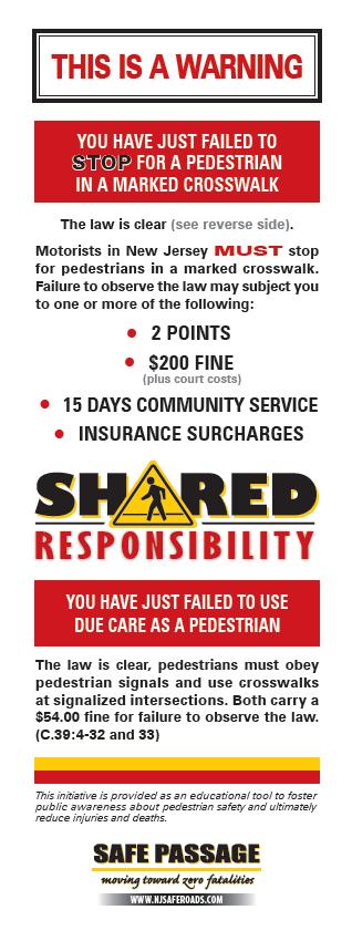
13 Install edge striping along Haledon Ave, which is very wide, to delineate the vehicular lane from the parking lane and as a traffic calming technique to reduce motorist travel speeds. Also install bicycle lanes along Haledon Avenue, which according to the Complete Streets section of Passaic County s Master Plan, Transportation Element, is considered a downtown street that provides a linkage to destinations within the City of Paterson. Further analysis would need to be conducted to assess whether bicycle lanes are appropriate for the roadway. Install pedestrian signage advising motorists of New Jersey s state law to stop for pedestrians in the crosswalk at un-signalized intersections along Garfield Ave and North Main St. Additional information about the law can be found on page 23. Repair the stairs and install railings along the Temple St. entrance to P.S. #28. 12


 students are walking to access P.S.")
14 Install signage and a temporary barrier (i.e., construction cones) on Matlock St., which functions as a morning and afternoon school bus drop-off area to discourage nonschool-related thru traffic. Matlock St. dissects the school grounds between Napier Academy and the recreational fields to the north. Repair stairway access to Garfield Ave. and develop a school travel plan to determine the route(s) students are walking to access P.S. #28 and Napier Academy. The stairways linking North 3rd to Garfield St., along Clinton and Jefferson Sts., are in poor condition and/or fenced-off. Jefferson St. Clinton St. Jefferson St. 13


15 Raise the stop sign at the Matlock and Temple Sts. intersection so that it s not blocked by vegetation and visible to motorists. Upgrade pedestrian signage, located at the south east corner of the North 2 nd and Haledon Sts. intersection, which is missing an arrow alerting motorists of the pedestrian crosswalk. Eliminate vehicular travel along Haledon St. at the triangle between North 1 st and North Main Streets, to simplify the intersection crossing and reduce pedestrian exposure to motor vehicles. Location of Haledon St. triangle Upgrade bus stop amenities, as listed below, along Temple St., Presidential Ave, and Haledon St. to enhance customer safety, convenience, and accessibility: Benches provide comfort for waiting transit customers. Bus Shelters, which should be wheelchair accessible, protect transit riders from inclement weather. Trash & Recycling Receptacles keep the area clear of clutter and debris. Street Trees enhance beautification efforts to make travel by transit more attractive. Bicycle Parking promotes multi-modal accessibility. Communication is vital to promoting transit ridership. Municipalities are encouraged to provide bus stop location and route information on way-finding signs, as well as install larger bus stop signs that aid not only residents but visitors in locating transit stops. In addition, NJTRANSIT offers my bus service which allows passengers to text the bus stop number and receive real-time information regarding the bus current location. The City of Paterson officials are encouraged to work with NJTRANSIT to ensure that my bus signs are installed at bus stops throughout the city. 14


16 Additional information on how to upgrade an existing or new bus stop, can be found in the NJTPA s Bus Stop Safety Toolbox, which may be found online at : Elected officials, municipalities, planning board members, and citizens are encouraged to use the Toolbox to partner with implementing agencies to enhance the safety and accessibility of an existing or new bus stop. The Toolbox was one product of a year-long Pedestrian Safety at and Near Bus Stops Study by the NJTPA to promote transit, livability and complete streets. Upgrade the telephone pole (# 60573P) along North Main St. that is unstable and in poor condition. Attention should also be given to the telephone pole located at the southeast corner of Presidential Blvd. and Temple St. Determine the feasibility of installing curb extensions at intersections along Presidential Ave, Haledon St., and Temple St., to discourage illegal parking and shorten pedestrian crossing distances. Replace missing trees along the planting strip between the sidewalk and roadway curbs near the intersection of Arch St. and Presidential Blvd. Develop a maintenance plan that engages community residents and leaders in maintaining the planting strip and discarding trash and other debris. 15

 is essential for making gains in traffic safety.")
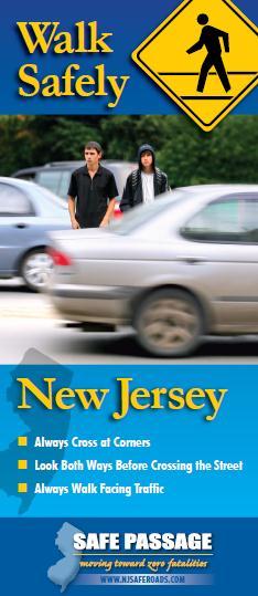
17 Enforce no parking on the sidewalk along Presidential Blvd. near the intersection with Clinton St. Missing tree near the intersection of Arch St. and Presidential Blvd. Cars park on the sidewalk along Presidential Blvd. near the intersection with Clinton St. Next Steps In addition to physical design improvements (engineering), it is recommended to identify opportunities to address pedestrian safety through enforcement and education. Leveraging the three E s (engineering, education and enforcement) is essential for making gains in traffic safety. While physical improvements will enhance comfort, safety, convenience, and accessibility for all roadway users, coupling the design recommendations outlined in this report with enforcement and education ensures a more successful walking environment, since motorist and pedestrian behaviors directly impact a community s walkability. Safety education programs focusing on both pedestrians and motorists are a priority in New Jersey because the state has been designated a Pedestrian Safety Focus State by the Federal Highway Administration (FHWA) due to its high number of pedestrian injuries and fatalities. Various government and private-sector organizations are taking an active role in addressing pedestrian safety at the community level, while the New Jersey Division of Highway Traffic Safety (NJDHTS) provides enforcement grants and educational materials focusing on aggressive driving and jaywalking. Information on NJDHTS grant opportunities and resources such as the Walk Safely New Jersey palm card can be found at and page 22 of this report. In addition, the New Jersey Department of Transportation (NJDOT) supports the Safe Routes to School (SRTS) programs by offering infrastructure grants and funds to SRTS coordinators for each of the 8 Transportation Management Associations (TMA) in the state. The SRTS programs focus on encouraging children to walk and bike to school where it is safe and where it is not safe, make it safe. Meadowlink TMA provided age appropriate pedestrian safety training to 9 classes at Napier Academy. Meadowlink TMA hopes to expand the program and be able to have an impact on a district-wide basis by assisting the schools to develop School Travel Plans. Schools with Travel Plans are more likely to be eligible for SRTS infrastructure funding from NJDOT. More about the SRTS program and grant opportunities can be found at: 16
18 The NJTPA website also provides links to a number of resources offering both national and local perspectives on pedestrian and traffic safety. Information may be found at Additional information on pedestrian safety, including effective countermeasures, can also be found on the FHWA website at The City of Paterson is encouraged to leverage these and other resources to implement pedestrian safety education and enforcement initiatives targeted at residents, employees and others who drive into and through the community. Conclusion The neighborhood east of P.S. #28 and Napier Academy in the City of Paterson is predominately residential and within walking distance of five public schools. It is located north of the Passaic River and the City s downtown, and offers transit access, via the 744 bus route, to the Paterson rail station, William Paterson University, and a nearby shopping center. Between 2006 and 2011, sixteen (16) pedestrians were injured in motor vehicle crashes in the neighborhood. Based on the feedback obtained during the Workshop walking audit conducted on April 30, the neighborhood is in need of numerous pedestrian upgrades including sidewalk repair. Workshop participants recommended that Ladder style crosswalks be installed at eight intersections. They also made a number of other suggestions including upgrading signals and installing pedestrian countdown signal heads, a pedestrian refuge island, mid-block crosswalks, pedestrian scale lighting, bicycle lanes, edge striping (as a traffic calming technique), and pedestrian signage at many locations. Stair access repair, school travel plans and bus stop and utility pole upgrades were also recommended. All of the recommendations outlined in this report would enhance the pedestrian safety for of neighborhood residents, promote a friendlier walking environment and improve destination access especially for elementary school-age children who are walking to and from the neighborhoods many schools. In addition to the engineering recommendations outlined in this report, employing enforcement and education tactics to reduce the incident of pedestrian crashes resulting in injuries is essential. City, neighborhood and school officials are encouraged to work with the local TMA (Meadowlink) to implement a Safe Routes to School programs as well as take advantage of education and enforcement grant opportunities provided by the New Jersey Division of Highway Traffic Safety. Pursuing partnerships and identifying champions within the community who will promote pedestrian safety as a shared responsibility between all roadway users is highly recommended. The design recommendations outlined in this Walkable Community Workshop report seek to improve the walking environment in the neighborhood adjacent to Napier Academy and P.S. #28, while supporting NJDOT s Complete Streets Policy. The report is a valuable tool that public, law enforcement and community officials, as well as citizens, are encouraged to leverage to improve the safety and mobility of all who live and work in the neighborhood as well as other neighborhoods throughout the City of Paterson. 17

19 Vicinity of Napier Academy Walkable Community Workshop Agenda P.S. #28, 200 Presidential Ave., City of Paterson 10AM-12:30PM April 30, 2012 Welcome :00 Walkable Community and Complete Streets Presentation...10:15 Complete Streets Policy Walking environment Walking Audit in the Vicinity of Napier Academy :40 In field assessment Design Solutions (Breakout Session) :30 Small team working groups Presentation of recommendations Priorities and action plan Next steps, questions, and wrap-up Adjourn :30 18
20 Workshop Participants Name Blythe Eaman Michael Deutsch Jerry Flack Andy Kaplan Michael Lysicatos Kelly Makino Nora Shepard Rev. Stafford Miller Elizabeth Thompson Hongchao Yu Organization Meadowlink Transportation Management Association Paterson Planning and Zoning Habitat for Humanity Rutgers, Transportation Safety Resource Center Passaic County DFN Community School & BGC Meadowlink Transportation Management Association St. Philips United Methodist Church North Jersey Transportation Planning Authority City of Paterson, Traffic Engineering 19


21 Pedestrian Image Resource: Edge Striping for Parking Curb Extensions High Visibility Crosswalk ADA Compliant Curb Ramps Bulb Out Bulb Out with Parking 20


22 Ladder Style Crosswalk Sample 21

23 22

24 23
Randolph Township Walkable Community Workshop Pedestrian Safety and Accessibility at the Intersection of Center Grove Road and Route 10
 2012 Randolph Township Walkable Community Workshop Pedestrian Safety and Accessibility at the Intersection of Center Grove Road and Route 10 This publication has been prepared as part of the North Jersey
Walkable Community Workshop McGinley Square Jersey City
 2011 Walkable Community Workshop McGinley Square Jersey City In Cooperation With: Bergen Communities United Women Rising Inc. City of Jersey City Table of Contents Background... 2 Figure 1: Location of
Walkable Community Workshop Report
 Walkable Community Workshop Report Annandale Historic District, Clinton Township, Hunterdon County June 14 th, 2010 Sponsored by: NJTPA 1 Table of Contents I. Purpose of Workshop II. III. Workshop Methodology
Senior Mobility Workshop Report
 Senior Mobility Workshop Report May 25 th, 2010 Historic Harsimus Cove District Sponsored by: NJTPA Table of Contents I. Purpose of Workshop II. III. Workshop Methodology Findings & Recommendations a.
NM-POLICY 1: Improve service levels, participation, and options for non-motorized transportation modes throughout the County.
 Transportation PRINCE WILLIAM COUNTY 2008 COMPREHENSIVE PLAN NON-MOTORIZED PLAN CONTENTS Goals, Policies, and Action Strategies Table 4 (Bike Facility Classifications and Descriptions) Table 5 (Bike Facility
MASTER BICYCLE AND PEDESTRIAN PLAN
 VILLAGE OF NORTHBROOK MASTER BICYCLE AND PEDESTRIAN PLAN DRAFT PLAN OPEN HOUSE May 2, 2018 AGENDA 1. Community Engagement 2. Vision and Goals 3. General Structure of Plan 4. Recommendations Overview 5.
CONNECTING PEOPLE TO PLACES
 CONNECTING PEOPLE TO PLACES 82 EAST BENCH MASTER PLAN 07 Introduction The East Bench transportation system is a collection of slow moving, treelined residential streets and major arteries that are the
Chapter 5. Complete Streets and Walkable Communities.
 Chapter 5. Complete Streets and Walkable Communities. 5.1 Description of Complete Streets. Cities throughout the world, and specifically the United States, are coming to embrace a new transportation and
CITY OF COCOA BEACH 2025 COMPREHENSIVE PLAN. Section VIII Mobility Element Goals, Objectives, and Policies
 CITY OF COCOA BEACH 2025 COMPREHENSIVE PLAN Section VIII Mobility Element Goals, Objectives, and Policies Adopted August 6, 2015 by Ordinance No. 1591 VIII MOBILITY ELEMENT Table of Contents Page Number
Agenda. Overview PRINCE GEORGE S PLAZA METRO AREA PEDESTRIAN PLAN
 PRINCE GEORGE S PLAZA METRO AREA PEDESTRIAN PLAN May 28, 2008 Agenda Welcome and introductions Project overview and issue identification Planning context and strengths Design challenges and initial recommendations
NJDOT Complete Streets Checklist
 Background The New Jersey Department of Transportation s Complete Streets Policy promotes a comprehensive, integrated, connected multi-modal network by providing connections to bicycling and walking trip
Solana Beach Comprehensive Active Transportation Strategy (CATS)
") Solana Beach Comprehensive Active Transportation Strategy (CATS) 3.0 Goals & Policies The Solana Beach CATS goals and objectives outlined below were largely drawn from the Solana Beach Circulation Element
Solana Beach Comprehensive Active Transportation Strategy (CATS) 3.0 Goals & Policies The Solana Beach CATS goals and objectives outlined below were largely drawn from the Solana Beach Circulation Element
Proposed. City of Grand Junction Complete Streets Policy. Exhibit 10
 Proposed City of Grand Junction Complete Streets Policy Exhibit 10 1 City of Grand Junction Complete Streets Policy Vision: The Complete Streets Vision is to develop a safe, efficient, and reliable travel
APPENDIX A: Complete Streets Checklist DRAFT NOVEMBER 2016
 APPENDIX A: Complete Streets Checklist DRAFT NOVEMBER 2016 Complete Streets Checklist MetroPlan Orlando s Complete Streets Checklist is an internal planning tool for staff to further implementation of
PRINCE GEORGE S PLAZA METRO AREA PEDESTRIAN PLAN
 PRINCE GEORGE S PLAZA METRO AREA PEDESTRIAN PLAN May 28, 2008 Agenda Welcome and introductions Project overview and issue identification Planning context and strengths Design challenges and initial recommendations
Chapter 2. Bellingham Bicycle Master Plan Chapter 2: Policies and Actions
 Chapter 2 Bellingham Bicycle Master Plan Chapter 2: Policies and Actions Chapter 2: Policies and Actions The Bicycle Master Plan provides a road map for making bicycling in Bellingham a viable transportation
Living Streets Policy
 Living Streets Policy Introduction Living streets balance the needs of motorists, bicyclists, pedestrians and transit riders in ways that promote safety and convenience, enhance community identity, create
Tonight is for you. Learn everything you can. Share all your ideas.
 Strathcona Neighbourhood Renewal Draft Concept Design Tonight is for you. Learn everything you can. Share all your ideas. What is Neighbourhood Renewal? Creating a design with you for your neighbourhood.
TOWN OF PORTLAND, CONNECTICUT COMPLETE STREETS POLICY
 TOWN OF PORTLAND, CONNECTICUT COMPLETE STREETS POLICY I. VISION, GOALS & PRINCIPLES VISION To improve the streets of Portland making them safer and more accessible for all users including pedestrians,
o n - m o t o r i z e d transportation is an overlooked element that can greatly enhance the overall quality of life for the community s residents.
 N o n - m o t o r i z e d transportation is an overlooked element that can greatly enhance the overall quality of life for the community s residents. 84 Transportation CHAPTER 11 INTRODUCTION Transportation
Watertown Complete Streets Prioritization Plan. Public Meeting #1 December 14, 2017
 Watertown Complete Streets Prioritization Plan Public Meeting #1 December 14, 2017 Goals for Public Meeting Overview of MassDOT Complete Streets Funding Program Educate the community on Complete Streets
C/CAG. Sunnybrae Elementary School Walking and Bicycling Audit. San Mateo-Foster City School District JUNE 2013
 Sunnybrae Elementary School Walking and Bicycling Audit JUNE 2013 San Mateo-Foster City School District C/CAG City/County Association of Governments of San Mateo County SUNNYBRAE ELEMENTARY SCHOOL WALKING
Improvements Infrastructure Gap Assessment and Improvements Street Striping
 Infrastructure Project Proposal The federal-aid Safe Routes to School program funds infrastructure/engineering projects that fall into two categories: Design (available only to School Development Authority
RESOLUTION NO ?? A RESOLUTION OF THE CITY OF NEPTUNE BEACH ADOPTING A COMPLETE STREETS POLICY
 RESOLUTION NO. 2018-?? A RESOLUTION OF THE CITY OF NEPTUNE BEACH ADOPTING A COMPLETE STREETS POLICY WHEREAS, safe, convenient, and accessible transportation for all users is a priority of the City of Neptune
HARRISON STREET/OAKLAND AVENUE COMMUNITY TRANSPORTATION PLAN
 HARRISON STREET/OAKLAND AVENUE Community Workshop #4: Draft Plan Review December 3, 2009 D E S I G N, C O M M U N I T Y & E N V I R O N M E N T INTRODUCTIONS Key Project Staff: Alisa Shen, Project Manager,
STEERING COMMITTEE MEETING June 17, Streetscape Overview Burlington Comprehensive Master Plan
 STEERING COMMITTEE MEETING June 17, 2015 Streetscape Overview Burlington Comprehensive Master Plan 1 Introduction Slide This slide show was presented to the Burlington Steering Committee on June 17, 2015
Broad Street Bicycle Boulevard Design Guidelines
 Broad Street Bicycle Boulevard Design Guidelines Building from the strategies introduced in the 2013 Bicycle Transportation Plan and community input received thus far, City Transportation Staff have identified
CITY OF BLOOMINGTON COMPLETE STREETS POLICY
 CITY OF BLOOMINGTON COMPLETE STREETS POLICY POLICY OBJECTIVE: The City of Bloomington will enhance safety, mobility, accessibility and convenience for transportation network users of all ages and abilities,
Vision: Traditional hamlet with an attractive business/pedestrian friendly main street connected to adjacent walkable neighborhoods
 N D. Focus Area II Vision: Traditional hamlet with an attractive business/pedestrian friendly main street connected to adjacent walkable neighborhoods Transit Road Focus Area II is located in the Hamlet
14 TH STREET TRANSPORTATION & STREETSCAPE DESIGN STUDY PLAN B PLAN B TRANSPORTATION & STREETSCAPE RECOMMENDATIONS
 14 TH STREET TRANSPORTATION & STREETSCAPE DESIGN STUDY PLAN B PLAN B TRANSPORTATION & STREETSCAPE RECOMMENDATIONS 141 Symbols Recommendations - Southern End of 14th Street Study Area Streetscape Each icon
CHAPTER 3: Vision Statement and Goals
 Davidson Walks & Rolls: Active Transportation Master Plan CHAPTER 3 Contents: Overview Vision Statement Measurable Goals Public Outreach CHAPTER 3: Vision Statement and Goals Overview The vision statement
INDOT Complete Streets Guideline & Policy
 INDOT Complete Streets Guideline & Policy INTRODUCTION The Complete Streets guidelines build upon multiple efforts and promote a multimodal transportation system that is integrated and sustains land use
Bicycle and Pedestrian Connectivity Study Phase 2
 Connectivity Study Phase 2 Process PROCESS OUTCOMES Phase Prepared By STEP I Public Participation and Outreach 1. RTP Outreach activities, and development of the Bike and Ped Task Force Phase 1 2011 OCPC
Roosevelt Estates Neighborhood Improvements
 Roosevelt Estates Neighborhood Improvements Transportation Alternatives Application May 5 th, 2016 Qualifying Activities Construction of on-road and off-road trail facilities for pedestrians, bicyclists,
ACTIVE TRANSPORTATION
 ACTIVE TRANSPORTATION Mobility 2040 Supported Goals Improve the availability of transportation options for people and goods. Support travel efficiency measures and system enhancements targeted at congestion
About the Studio. Edward J. Bloustein School of Planning and Public Policy - Rutgers University
 About the Studio Edward J. Bloustein School of Planning and Public Policy - Rutgers University Purpose of studio: Help City of Bayonne apply for Safe Routes to School (SRTS) funding by producing a School
Residential Traffic Calming Program Guide. Town of Ashland, Virginia
 Residential Traffic Calming Program Guide Town of Ashland, Virginia August 1, 2006 TABLE OF CONTENTS A. INTRODUCTION... 1 B. GOALS... 1 C. CRITERIA... 1 D. IDENTIFYING NEIGHBORHOOD TRAFFIC CONCERNS...
1.0 EXECUTIVE SUMMARY
 1.0 EXECUTIVE SUMMARY The Active Transportation Plan is a guide to accomplish the Town s vision for developing a network of sidewalks, on-road bicycle facilities, and trails that allow for safe and convenient
Perryville TOD and Greenway Plan
 Perryville TOD and Greenway Plan Greenway Glossary Pathway: A bicycle and pedestrian path separated from motorized vehicular traffic by an open space, barrier or curb. Multi-use paths may be within the
City of Novi Non-Motorized Master Plan 2011 Executive Summary
 City of Novi Non-Motorized Master Plan 2011 Executive Summary Prepared by: February 28, 2011 Why Plan? Encouraging healthy, active lifestyles through pathway and sidewalk connectivity has been a focus
REGIONAL BICYCLE AND PEDESTRIAN DESIGN GUIDELINES
 REGIONAL BICYCLE AND PEDESTRIAN DESIGN GUIDELINES November 16, 2011 Deb Humphreys North Central Texas Council of Governments Bicycle and Pedestrian Advisory Committee Snapshot of the Guide 1. Introduction
Item to be Addressed Checklist Consideration YES NO N/A Required Description Complete Streets Guidelines
 Passaic County Complete Streets Checklist - Concept Development Project Name Item to be Addressed Checklist Consideration YES NO N/A Required Description Complete Streets Guidelines Existing Plans Have
EXECUTIVE SUMMARY. Vision
 Vision Walking and bicycling in Salt Lake City will be safe, convenient, comfortable, and viable transportation options that connect people to places, foster recreational and economic development opportunities,
5. RUNNINGWAY GUIDELINES
 5. RUNNINGWAY GUIDELINES These guidelines should be considered collectively when making runningway decisions. A runningway is the linear component of the transit system that forms the right-of-way reserved
PEDESTRIAN ACTION PLAN
 ATTACHMENT 2 CITY OF SANTA MONICA PEDESTRIAN ACTION PLAN CITY OF SANTA MONICA PEDESTRIAN ACTION PLAN This page intentionally left blank EXECUTIVE SUMMARY CHAPTER 1 EXECUTIVE SUMMARY Setting the Stage
Bikeway action plan. Bicycle Friendly Community Workshop March 5, 2007 Rochester, MN
 Bikeway action plan Summary The was held on March 5, 2007 at the Rochester Mayo Civic Center. The workshop was hosted by Rochester-Olmsted County Planning Department in collaboration with the League of
Commerce Street Complete Street Project from Good Latimer Expressway to Exposition Avenue
 Commerce Street Complete Street Project from Good Latimer Expressway to Exposition Avenue T A N Y A B R O O K S A S S I S T A N T D I R E C T O R M O B I L I T Y P L A N N I N G M O B I L I T Y A N D S
2014/2015 BIKE ROUTE PLAN 83 AVENUE PROTECTED BIKE LANE
 About the Project 2014/2015 BIKE ROUTE PLAN The City of Edmonton is planning a major bike route on the south side of Edmonton. This bike route is one part of a plan to provide citizens with transportation
CONNECTIVITY PLAN. Adopted December 5, 2017 City of Virginia Beach
 CONNECTIVITY PLAN Adopted December 5, 2017 City of Virginia Beach CONTENTS 1.0 Background & Purpose... 2 2.0 Existing Inventory & Analysis... 3 ViBe District Existing Walking Conditions... 4 3.0 ViBe District
USDOT Bicycle and Pedestrian Safety Initiative: Safer People and Safer Streets. Barbara McCann, USDOT Office of Policy
 { USDOT Bicycle and Pedestrian Safety Initiative: Safer People and Safer Streets Barbara McCann, USDOT Office of Policy 4 Steps from policy to practice Creating multi-modal streets means: 1. Change Decision-Making
Pedestrian, Bicycle and Traffic Calming Strategic Implementation Plan. January 18, 2011
 Pedestrian, Bicycle and Traffic Calming Strategic Implementation Plan January 18, 2011 Tonight s Agenda Receive update on project Provide feedback on two policy issues Complete Streets Policy Project Prioritization
Corpus Christi Metropolitan Transportation Plan Fiscal Year Introduction:
 Introduction: The Safe, Accountable, Flexible, Efficient Transportation Equity Act: A Legacy for Users (SAFETEA-LU) has continued the efforts started through the Intermodal Surface Transportation Efficiency
West Capitol Avenue Road Rehabilitation and Safety Enhancement Project
 West Capitol Avenue Road Rehabilitation and Safety Enhancement Project Stakeholder Focus Group Meeting #2 Tuesday, August 28, 2018 7:00 8:00 a.m. West Sacramento City Hall 1110 West Capitol Avenue, West
complete streets design and construction standards public primer City of Edmonton
 complete streets design and construction standards public primer City of Edmonton introduction Complete Streets are streets for everyone: people who walk, wheel, bike, take transit, or drive. They are
Vision. Goals and Objectives. Walking
 Vision Walking and biking is an accepted and valued part of everyday life in Portsmouth. People of all ages and abilities include walking and biking as part of their daily activities which helps to make
Uptown West Neighbourhood Transportation Study
 Uptown West Neighbourhood Transportation Study Public Open House #2 Information for Review As we move towards the second public open house on May 6, 2014, information on the alternative solutions that
Chapter VISION, MISSION, AND GOALS AND OBJECTIVES. Vision. Mission. Goals and Objectives CONNECTING COMMUNITIES ACROSS THE ST.
 VISION, MISSION, AND GOALS AND OBJECTIVES Chapter 3 The Plan s vision, mission, and goals and objectives were developed through a series of interactive exercises with the Citizens Advisory Committee (CAC)
Lee s Summit Road Improvement Study Public Open House June 7, 2007 Summary of Comment Card Responses
 Lee s Summit Road Improvement Study Public Open House June 7, 2007 Summary of Comment Card Responses Introduction At the Lee s Summit Road Improvement Study Public Open House held Thursday, June 7, 2007
Safe Routes to School Action Plan Aberdeen, Idaho
 Background Aberdeen, Idaho is a largely agricultural community of nearly 2,000 people and is located in the southeast portion of the state on the western edge of American Falls Reservoir. The community
PRESS RELEASE San Joaquin Council of Governments
 PRESS RELEASE San Joaquin Council of Governments For Immediate Release February 23, 2018 Contact: Nicole Gorham, 235-0582 gorham@sjcog.org SJCOG Board Awards $19.63 Million in Measure K Bicycle, Pedestrian,
Morristown, NJ Complete Streets Policy
 Morristown, NJ Complete Streets Policy Introduction A Complete Street is defined as a means to provide safe access for all users by designing and operating a comprehensive, integrated, connected multi-modal
5 Transit & Traffic. Overview
 5 Transit & Traffic Overview Montgomery Place s roadways and overall traffic circulation are unique in the city due to the narrow streets and avenues with boulevards; however, no sidewalks or curbs in
Bicycle Master Plan Goals, Strategies, and Policies
 Bicycle Master Plan Goals, Strategies, and Policies Mobilizing 5 This chapter outlines the overarching goals, action statements, and action items Long Beach will take in order to achieve its vision of
MARTIN LUTHER KING JR. WAY
 OCTOBER 2011 40 Vision and Goals The Martin Luther King, Jr. Way Illustrative Master Plan that follows has been developed through a process of community involvement. It expresses a long term vision for
Montclair s Complete Streets Experience
 Presented by: Hon. Jerry Fried, Mayor Montclair Township About Montclair Six square miles Six commuter rail stations Four local bus routes (NJ Transit) Two private commuter bus routes Five business districts
Goal 3: Foster an environment of partnerships and collaboration to connect our communities and regions to one another.
 Non-Motorized Transportation Plan (NMTP) Draft Vision, Goal and,, Tri-County Regional Planning Commission (TCRPC) Purpose The purpose of the Tri-County Regional Planning Commission (TCRPC) Non-Motorized
WELCOME. Thank you for joining us at the Second Public Workshop for the Carlsbad Pedestrian Master Plan. We look forward to receiving your feedback.
 City of Carlsbad Pedestrian Master Plan: WELCOME WELCOME Please Sign In Provide Input at Flip Charts Review Boards Presentation of Draft Plan Thank you for joining us at the Second Public Workshop for
Complete Streets for Niagara A working method to visualize the creation of a complete street June 20th, 2013
 Complete Streets for Niagara A working method to visualize the creation of a complete street June 20th, 2013 C O N T E N T S Introduction and background of the report What is a complete street? What can
BIKE PLAN CONTENTS GATEWAY
 CONTENTS Acknowledgments...vii Great Rivers Greenway District Board of Directors... vii Great Rivers Greenway District Staff... vii Project Consultants... vii Committees... viii Citizens Advisory Committee
Paoli Road Improvement Feasibility Study
 Paoli Road Improvement Feasibility Study & Public Participation Project March 24, 2015 Prepared for: Tredyffrin Township Prepared by: McMahon Associates, Inc. with Town Planning Partnership, LLC Glackin
Complete Streets. Designing Streets for Everyone. Sarnia
 Complete Streets Designing Streets for Everyone Sarnia Complete Streets ~ Sarnia ~ 2018 Introduction Our City is made up of a network of streets that we use to go for a walk, cycle to work, drive to the
ADA Transition Plan. City of Gainesville FY19-FY28. Date: November 5, Prepared by: City Of Gainesville Department of Mobility
 ADA Transition Plan FY19-FY28 Date: November 5, 2018 Prepared by: City Of Gainesville Department of Mobility 1.0 INTRODUCTION 1.1 BACKGROUND The federal statute known as the Americans with Disabilities
G AT E WAY PLAN. Community BRIEFING KIT GATEWAY BIKE
 G AT E WAY PLAN GATEWAY BIKE Community BRIEFING KIT PLAN August 2016 TABLE OF CONTENTS INTRODUCTION... 1 THE BENEFITS OF A BIKEABLE COMMUNITY... 2 ECONOMY...2 SAFETY...3 HEALTH...3 HOUSEHOLD SPENDING...3
City of Charlottesville Bicycle and Pedestrian Master Plan Update
 City of Charlottesville Bicycle and Pedestrian Master Plan Update September 17, 2014 I. Welcome and meeting overview II. Project status update III. Network overview IV. Break-out groups Pedestrian Network
Bicycle Boulevards and Neighborhood Greenways
 Bicycle Boulevards and Neighborhood Greenways Traffic Safety is Improving for Everyone 90 80 70 60 50 40 30 20 10 0 PORTLAND: TOTAL TRAFFIC FATALITIES 1986-2008 1986 1987 1988 1989 1990 1991 1992 1993
Mayor s Bicycle Advisory Council. Wednesday, December 13 th, 2017
 Mayor s Bicycle Advisory Council Wednesday, December 13 th, 2017 Bicyclist Fatalities, Year to Date (January 1 November 30, 2017) - MBAC Briefing Bicyclist Fatality Statistics Year to date total, 2017
FLORIDA DEPARTMENT OF TRANSPORTATION DISTRICT 7 DISTRICT WIDE BICYCLE/PEDESTRIAN ACCESS TO TRANSIT SAFETY ASSESSMENT AND IMPROVEMENT PLAN
 FLORIDA DEPARTMENT OF TRANSPORTATION DISTRICT 7 DISTRICT WIDE BICYCLE/PEDESTRIAN ACCESS TO TRANSIT SAFETY ASSESSMENT AND IMPROVEMENT PLAN TRANSIT SAFETY ASSESSMENT SR 55/US 19 AT 80 TH AVE N DRAFT JUNE
SAFE ROUTES TO SCHOOL
 SAFE ROUTES TO SCHOOL Forest Ridge Elementary School Existing Conditions and ACTION PLAN > Oak Creek - Franklin Joint School District Table of Contents CONTEXT Enrollment Boundaries
This page intentionally left blank.
 This page intentionally left blank. COMMUNITY Coweta Community Overview Coweta Coweta, a residential community located in Wagoner County, is a suburb of Tulsa situated southeast of the metropolitan area
Chapter Four NON-INFRASTRUCTURE RECOMMENDATIONS. 5 E s. 5 E s. Education. Encouragement. Enforcement. Engineering. Evaluation
 Chapter Four NON-INFRASTRUCTURE RECOMMENDATIONS 5 E s The non-infrastructure recommendations in the Bicycle and Pedestrian Master Plan will help to foster a culture and environment that will help to increase
City of Ann Arbor Pedestrian Safety & Access Task Force
 City of Ann Arbor Pedestrian Safety & Access Task Force Community Wide Meeting #2 Wednesday, March 25 th 6:30 to 8:30 PM Multi-purpose Room, Downtown Library The Greenway Collaborative, Inc. www.greenwaycollab.com
4 MOBILITY PLAN. Mobility Plan Objectives. Mobility Context. 1. Integrate with Local and Regional Transit Improvements
 Harbor Mixed Use CHAPTER Transit Corridor 4: Mobility Plan 4 MOBILITY PLAN Mobility Plan Objectives The Harbor Corridor Plan seeks to expand and improve the ways that people move along and through the
5 CIRCULATION AND STREET DESIGN
 5 CIRCULATION AND STREET DESIGN This chapter describes circulation and streetscape improvements proposed for the Northwest Chico Specific Plan Area. It includes detailed design specifications for existing
Non-Motorized Transportation 7-1
 Non-Motorized Transportation 7-1 Transportation facilities no longer mean just accommodating a vehicle powered by a combustion engine. Pedestrian and non-motorized facilities are important modes of travel
7/23/2017 VIA . Michael Hanebutt City of Sacramento Community Development Department 300 Richards Boulevard, 3 rd Floor Sacramento, CA 95811
 7/23/2017 VIA EMAIL Michael Hanebutt City of Sacramento Community Development Department 300 Richards Boulevard, 3 rd Floor Sacramento, CA 95811 RE: 65 th Street Apartments (DR17-220) Dear Mr. Hanebutt:
Walkable Communities: National Best Practices and Applications in Memphis, TN
 Walkable Communities: National Best Practices and Applications in Memphis, TN Dr. Stephanie Ivey Assistant Professor Herff College of Engineering Department of Civil Engineering Agenda Walkable communities
CURBSIDE ACTIVITY DESIGN
 5 CURBSIDE ACTIVITY DESIGN This chapter provides design guidance for separated bike lanes adjacent to curbside activities including parking, loading and bus stops. Typical configurations are presented
Cycle Track Design Best Practices Cycle Track Sections
 Design Best Practices Sections It is along street segments where the separation and protection methods of cycle tracks offer more comfort than conventional bicycle lanes, and are more attractive to a wide
Board-Approved Funding Awards for Cycle 4 Active Transportation Grant Program Projects (in Order of Project Rankings) Approved on
 Approved on") CAPITAL Large Category Projects Board-Approved Funding Awards for Cycle 4 Active Transportation Grant Program Projects (in Order of Project Rankings) Approved on 07-27-18 1 La Mesa University Ave Pedestrian
CAPITAL Large Category Projects Board-Approved Funding Awards for Cycle 4 Active Transportation Grant Program Projects (in Order of Project Rankings) Approved on 07-27-18 1 La Mesa University Ave Pedestrian
COWETA HIGH SCHOOL AND EAST HIGHWAY 51
 COWETA HIGH SCHOOL AND EAST HIGHWAY 51 Lack of sidewalks along Ben Lumpkin Rd. Lack of crosswalks and ramps at intersection. Hwy 51 is wide to cross as a pedestrian. No ADA compliance or connection to
Pedestrian Safety: A Federal Perspective. Emmett McDevitt Transportation Safety Engineer September 28, 2010
 Pedestrian Safety: A Federal Perspective Emmett McDevitt Transportation Safety Engineer September 28, 2010 Pedestrian Fatalities by Year in US (1997-2009) 6,000 5,000 4,000 3,000 2,000 1,000 0 1997 1998
Introduction.
 2307-1.0. Introduction. Delaware s Safe Routes to School (SRTS) Program was established September 10, 2002 when Governor Ruth Ann Minner signed Senate Bill 353 of the 141st General Assembly of Delaware
Multimodal Connectivity: Walking & Wheeling to Transit
 Multimodal Connectivity: Walking & Wheeling to Transit Joanne Waszczak FTA Office of Budget & Policy APTA Sustainability & Public Transportation Workshop August 4, 2014 Walking and Wheeling to Transit
Pedestrian and Bicycle Improvements in Balboa Park Station Area
 Pedestrian and Bicycle Improvements in Balboa Park Station Area Jamie Parks & Jen Wong, SFMTA, Livable Streets December 15, 2015 Balboa Park Station CAC Monthly Meeting Vision Zero SF Zero traffic deaths
What Is a Complete Street?
 Session 5 Charleen Zimmer, AICP, Zan Associates May 5-7, 2010 What Is a Complete Street? May 2010 5-1 Not a Complete Street More of a Complete Street May 2010 5-2 Benefits of Complete Streets Safety for
STONY PLAIN ROAD STREETSCAPE
 Jasper Place Revitalization Strategy: Vision The people involved in the Jasper Place Revitalization Strategy envision: Goal 1: Feeling safe in our community Create a community where feeling safe is common--where
Table of Contents Introduction. 2 Purpose of the Plan...2 The Benefits of Walking and Bicycling...3 Vision and Goals of the Plan...
 BICYCLE AND This plan was created through a grant from the Healthy Communities Program with the cooperation of the City of Cynthiana, Cynthiana Main Street, Cynthiana-Harrison County-Berry Joint Planning
Safe Routes to School: Munroe Elementary Walk Audit Report. Image: Drexel, Barrell & Co.
 Safe Routes to School: Munroe Elementary Walk Audit Report Image: Drexel, Barrell & Co. April 12, 2016 OVERVIEW As part of the 2014/2015 Denver Safe Routes to School (SRTS) Program, WalkDenver coordinated
5. Pedestrian System. Accomplishments Over the Past Five Years
 5. Pedestrian System Accomplishments Over the Past Five Years The Alamo Area Metropolitan Planning Organization (MPO) and its partner agencies recognize the importance of improving pedestrian mobility.
Hennepin County Bicycle and Pedestrian Planning
 Hennepin County Bicycle and Pedestrian Planning 1 Value of bicycle and sidewalk systems Safety Livability Mobility Health Personal Finances Economic Sustainability Clean Air Recreation Parking and congestion