APPENDIX A Community Pedestrian Workshops
|
|
|
- Evan Cain
- 5 years ago
- Views:
Transcription
1 Appendices 67
2 APPENDIX A Community Pedestrian Workshops Summary of Community Workshop No.1 Meeting Date: Tuesday, March 24, 2015 at 6 p.m. OVERVIEW As part of the planning process for the first-ever Topeka Pedestrian Master Plan, a community workshop was held on Tuesday, March 24, 2015 from 6 to 8 p.m. at the Holliday Building (620 SE Madison) in downtown Topeka. Its purpose was to: Gather community feedback about: - The Ideas for a possible vision and goals for walkability in Topeka - Key issues, problems and/or concerns with walkability in the community - Potential strategies/solutions for addressing key issues, problems, and/or concerns - Top priorities for walkability - Other comments Incorporate the information gathered into a review and inventory of existing sidewalk and pedestrian facilities. Use the information to inform the selection of focus areas and recommendations that could be included in the initial and final drafts of the pedestrian plan. A total of 23 people attended the workshop, including elected officials, staff from the City of Topeka and its Metropolitan Planning Organization, Neighborhood Improvement Areas (North Topeka West, Central Highland Park, and others), Topeka Metro, the Advisory Committee for the Topeka Pedestrian Master Plan, Shawnee County Parks and Recreation Department, Heartland Healthy Neighborhoods, Security Benefit, residents, the media, and others. Notice for the meeting was provided via a combination of press release, social media posts, and e-blasts via NEXTDOOR: Topeka. The workshop began with a short presentation that provided an overview of pedestrian planning and outlined key elements of the planning process for the Topeka Pedestrian Plan, including its intended adoption by year s end and implementation funding available via the City s capital improvements program. Then participants were asked to use maps, dots, and markers to share their opinions about the best (green dots and markers) and worse (red dots and markers) places for walking in Topeka, potential improvement strategies for issues (blue dots and markers), and priority improvement locations (yellow dots). An online version of the mapping exercise was made available via topeka.org/pedplan through April 30. Workshop participants also discussed their favorite places to walk today, where they would like to walk in the future, important issues to address through the pedestrian master plan, and key items to accomplish in the coming years. At the conclusion of the workshop, participants were advised that they could continue the evening s discussion by visiting the online town hall meeting at topeka.mindmixer.com and/or responding to the survey at topeka.org/pedplan. 68
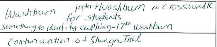
3 Discussion During the workshop, three tables of participants (also known as Groups 3, 4, and 5) shared their feedback with the study team. A summary of their responses to key questions regarding favorite walking locations, key issues, and priority accomplishments are included in the pages that follow. Group 3 Group 4 Group 5 Where s your FAVORITE place to walk? o Shunga Trail o Trails looping around Governor s Mansion o Shunga Trail in East Topeka o Downtown Topeka o In my neighborhood near the Library. Walk to the nearby shops, Walgreens, Doctor s Office, etc. o Santa Fe Park and Oakland- Billard Park in Northeast Topeka o Central Highland Park and Lake Shawnee o McFarland Farms Neighborhood o Shunga Trail o Highland Park o Along Levee o Downtown Lawrence; close to shopping, food, entertainment, and other daily needs o Gage Park o Mt. Hope Cemetery and Seabrooke Neighborhood o Trails o Neighborhood o Washburn University o Older neighborhoods o Ward Meade Neighborhood Improvement Area o Around Chesney Park (Mural at 19th and Weston) 69
4 Group 3 Group 4 Group 5 Where would you like to walk in the FUTURE? o No responses o To the Zoo, from McFarland Farms Neighborhood o To work, from Briarwood to High Crest o To Downtown and Lake Shawnee, from California Ave o Improved accessibility in North Topeka o Downtown Topeka; hustle and bustle in future o Improved Gage Park o No sidewalks in Seabrooke neighborhood, would love to have sidewalks in this neighborhood. o North side of Fist Street between Clay and Fillmore o Trails o Neighborhood o All places with no sidewalks or curbs, just ditches. Dangerous. o N. Tyler Road o NW Taylor Road o N Lineman Road; kids have nowhere to walk; pedestrians have been hit and killed. Also, dangerous railroad track crossing. o East Topeka o South Topeka Boulevard o Downtown Topeka o Old Prairie Town (124 NW Fillmore) o 6th Street Business Corridor o No sidewalk down Oakley o East Topeka and other districts that need to be improved at the same level as those in West Topeka o North side of Fist Street between Clay and Fillmore 70
5 Group 3 Group 4 Group 5 In 2020 walking should be in Topeka? o No responses o Easy o Safe o Plentiful o Connected o Safe: Don t have to walk in ditches, in the street, or jump out of the way of trucks o Practical, easy to walk and don t have to go out of your way o Accessible (ADA too) o Connected and complete (No holes) o Protected by adopted policy o Aesthetically pleasing (landscaped, weed free) o Grades aren t dangerous (grade differentials addressed); often caused by uprooting trees o Walking on sidewalks that are in good repair o Sidewalks that matchup on both sides of the street o Complete Streets and/or Complete Corridors so bikes and cars work well together 71
6 Group 3 Group 4 Group 5 What is the BIGGEST ISSUE facing walkability today? o No. 1 - Safe sidewalks to and around all Topeka schools; Implementation of Safe Routes to Schools. o No Limited accessibility around West Ridge Mall. Ramps are not provided at most intersections. o No. 3 - Safety and Connectivity. No sidewalks or intermittent sidewalks along Washington Street and Hudson Boulevard in the Highland Park Neighborhood. o No. 4 - Limited accessibility in neighborhoods around Hospitals and Medical Buildings. o No Limited accessibility for mobility impaired EVERYWHERE o No. 1 - Safety, including: Signal Light timing Lighting Lack of Sidewalk Disrepair Not to Code Pedestrians vs. Vehicles Auto Oriented Open Ditches along roadways o No. 2 - Connectivity, including: Large, privately owned land tracts are barriers o Central Topeka, continuity issues o Sidewalks are mental boundaries between public and private They are the ribbon that binds neighbors together; also helps with crime prevention o East Topeka, North Topeka, and Oakland Neighborhoods have been forgotten about o Need better planning for the development of Central Topeka o Need better working relationship between City and County 72
7 Group 3 Group 4 Group 5 What s the top thing you d like the Topeka Pedestrian Master Plan to ACCOMPLISH in the next five years? o No responses o No. 1 - Highland Park Neighborhood Improvements o No. 2 - Neighborhood Improvements along Gage Boulevard between Gage Park and Big Shunga Park o No. 3 - North Topeka Improvements (around Kansas Ave.) o Overarching policy to put in sidewalks where they don t already exist. (Note: Be careful and don t force them on areas that don t want them). o Coordinate new street development with sidewalk development so sidewalks aren t torn up during construction. Meeting Attendees Overall Outreach Ideas/Concerns Reach those who don t have computers Neighborhood associations are willing to send and/or hand out hardcopies of the online survey Use sidewalk inventories that neighborhood associations have already completed o MPO can attend neighborhood meetings and provide updates to them during the planning process 73

8 - -rropeka, Kansas / - t ; I --J-r Topeka Pedestrian Plan --- -, lil!me MIies J. / i--_ j -=-- 1 I 'r S H W! _:_:_ ,. J_ I,- I :-.-.::: ,-- -l-----,...---t-- 1,..._.--r- \ I S H A W N E E I C 1 0 U N T Y 74 /[--

9 75


10 76


11 77


12 78


13 79


14 _ Topeka, Kansas / - I Topeka Pedestrian Plan -S H II A W N E E C O U N :_ T.:...: Y ----,- J f---- I I I I t,..,, I...::... r-"- -..::J I i,... - I I / I \ \ -t-- -r,. - : t--w 80 \ J S H A W N E E C i O U N T Y ;1---, I f'j I I


15 81


16 82


17 83


18 84


19 85

20 Topeka.Kansas. - Topeka Pedestrian Plan I J. I ' I S H W E T!_ Y _L_ f-:-t-= -:---.:::--: --= Kansas Rrver \ ;.-,...--,-... u_-1..j...,,! -t«-=-;,:-, -;i-\ I i I - 86 \ I S H A W N E E - cl O U N T Y { It _,._ -.CS I


21 87


22 88


23 89


24 90


25 91
26 Community Pedestrian Workshops Summary of Community Workshop No. 2 Meeting Date: Wednesday, January 20, 2016 at 6 p.m. OVERVIEW As part of the planning process for the first-ever Topeka Pedestrian Master Plan, a community meeting was held on Wednesday, January 20, 2016 from 6 to 8 p.m. at the Holliday Building (620 SE Madison) in downtown Topeka. Its purpose was to: Gather community feedback about the draft pedestrian master plan, specifically its: - Vision - Goals - Action Steps - Projects - Other comments Incorporate the feedback received into the final draft of the master plan. A total of 15 people attended the meeting, including elected officials, staff from the City of Topeka and its Metropolitan Planning Organization, neighborhood organizations, and others. Notice for the meeting was provided via a combination of press releases, social media posts, and e-blasts. Eleven (11) comment forms were returned. DISCUSSION The meeting began with a short presentation that provided an overview of the recommendations in the draft Topeka Pedestrian Plan, including its goals, action steps, maps, and priority improvement projects plus associated planning-level (pre-engineering) cost estimates. In response, meeting participants provided the following comments: Goal 1 A complete pedestrian network connecting all neighborhoods o Huntoon at 12th Street: No sidewalks, scary Why isn t it included? Part of the ½-cent sales tax as a large complete streets project. Complete streets projects involve lighting and all modes of transportation. Goal 2 Maintained sidewalks for safe travel at all times o Going to recommend more funding for the 50/50 cost-share program? Yes and include brick sidewalk eligibility. - Will there by a program expansion on a sliding scale by neighborhood and/or income? o How much priority was given to trail connectivity? 92
27 Goal 3 A safe and comfortable walking environment o Priority for projects related to safety and comfort (lighting, etc)? o What about neighborhood/pedestrian-scale lighting? o Elmhurst: Proper tree trimming along sidewalks is an issue Was this discussed? - Is shrub encroachment on sidewalks a code compliance issue? - Difference between visibility for cars versus that for walkers? Goal 4 A culture of walking o Is the Safe Routes to School Study for Quincy Elementary comparable to the county health study? o How would you implement improvements for Action 4c - Promote walking in neighborhoods through mixed use development and redevelopment along neighborhood corridors? o What do other cities coalitions look like and how does Topeka compare to them (re: Action 4B - Establish a complete streets advisory committee)? - Are resources and sources available? Similar information will be included in the final draft plan. - Are there best practices? Similar information will be included in the final draft plan. o What are we doing for areas that don t have sidewalks? IMPROVEMENT PROJECTS Curb ramps o How were costs and improvements determined? If one ramp was missing, the sidewalk inventory assigned costs for improving all of the ramps at the intersections. Truncated domes would be added to existing ramps that don t have them. All ramps would be complete by Crosswalks o Costs should be increased to $25,000 per flashing pedestrian signals. o Gage and Fairlawn need flashing pedestrian signals. Improvement Locations o Does the heat map include the major street reconstruction projects? No. o Why was the Jardine School area given priority? It s an area of high pedestrian demand, noted by the stakeholder advisory committee, and is planning to expand. o How were the focus areas selected? By combining the heat map, stakeholder committee comments, discussions with neighborhood groups, etc. o Ward Meade Lots of work in the neighborhood to improve walkaibilty. Why not support a neighborhood that s already done work securing planning grants, etc? Other neighborhoods should be doing what we re doing. Add previous planning in the neighborhood as a criterion for selection. 93
28 Heat wasn t high due to neighborhood health Part is at risk Heat map is missing some elements Don t let the map discourage good neighborhood work. Group E Corridors and Complete Streets Linkages o Competitive pool of money for improvements that weren t inventoried. After plan adoption, citizen advocacy could accelerate and increase funding for pedestrian projects. Funding sources are listed in the plan. We can revisit and update the plan, incorporate funding sources, etc. Funding beyond a sales tax is needed. Lots of people are working on walkability Need to know more about funding and neighborhood work. Walkability is trendy now Spin it to get projects funded. OTHER COMMENTS Are you trying to eliminate brick sidewalks? No. City policy goal is preservation. o Hard for people in wheelchairs. o Repair for brick sidewalks is needed less often. o City has brick streets (95% are to be preserved). 42% of survey respondents said they wanted to walk to shops, etc but busy streets were given low priority Contradiction? Wanted to avoid double county streets and commercial parcels. Assumed commercial corridors were part of pedestrians route to destinations. o Bus routes are high but there aren t many routes Weighting sidewalks within a ½-mile buffer is incorrect and should extend farther as a priority area. o Downtown s red on the heat map There are a lot of sidewalks there. COMMENT FORMS Comment forms were given to all meeting participants. After the meeting, a total of 11 were returned. The responses have been tabulated and appear in the table on pages of this report. 94
29 95
30 96
31 97
PRINCE GEORGE S PLAZA METRO AREA PEDESTRIAN PLAN
 PRINCE GEORGE S PLAZA METRO AREA PEDESTRIAN PLAN May 28, 2008 Agenda Welcome and introductions Project overview and issue identification Planning context and strengths Design challenges and initial recommendations
Agenda. Overview PRINCE GEORGE S PLAZA METRO AREA PEDESTRIAN PLAN
 PRINCE GEORGE S PLAZA METRO AREA PEDESTRIAN PLAN May 28, 2008 Agenda Welcome and introductions Project overview and issue identification Planning context and strengths Design challenges and initial recommendations
APPENDIX D Pedestrian Plan Stakeholder Committee Notes
 APPENDIX D Pedestrian Plan Stakeholder Committee Notes Stakeholder Committee Meeting #1 March 25, 2015 Holliday Building Conference Room, 1 st Floor 620 SE Madison, Topeka 4:00 6:00 p.m. Members Present
WELCOME. Thank you for joining us at the Second Public Workshop for the Carlsbad Pedestrian Master Plan. We look forward to receiving your feedback.
 City of Carlsbad Pedestrian Master Plan: WELCOME WELCOME Please Sign In Provide Input at Flip Charts Review Boards Presentation of Draft Plan Thank you for joining us at the Second Public Workshop for
CHAPTER 3: Vision Statement and Goals
 Davidson Walks & Rolls: Active Transportation Master Plan CHAPTER 3 Contents: Overview Vision Statement Measurable Goals Public Outreach CHAPTER 3: Vision Statement and Goals Overview The vision statement
DRAFT. Table of Contents. Background
 Douglas County Table of Contents Existing Infrastructure 86 Funding 89 Policy and Program Recommendations 90 Infrastructure Recommendations 92 Conclusion 95 Background Home to 4,500 residents and Baker
MASTER BICYCLE AND PEDESTRIAN PLAN
 VILLAGE OF NORTHBROOK MASTER BICYCLE AND PEDESTRIAN PLAN DRAFT PLAN OPEN HOUSE May 2, 2018 AGENDA 1. Community Engagement 2. Vision and Goals 3. General Structure of Plan 4. Recommendations Overview 5.
Ann Arbor Downtown Street Plan
 1 Ann Arbor Downtown Street Plan Public Workshop #1 We know that. 2 Public right-of-way (streets, sidewalks, and alleys) make up 30% of the total District area of downtown. Streets need to provide mobility
City of Novi Non-Motorized Master Plan 2011 Executive Summary
 City of Novi Non-Motorized Master Plan 2011 Executive Summary Prepared by: February 28, 2011 Why Plan? Encouraging healthy, active lifestyles through pathway and sidewalk connectivity has been a focus
TOWN OF WILLIAMSTON, SC BICYCLE AND PEDESTRIAN MASTER PLAN TOWN OF WILLIAMSTON, SC BICYCLE AND PEDESTRIAN MASTER PLAN
 TOWN OF WILLIAMSTON, SC BICYCLE AND PEDESTRIAN MASTER PLAN Americans Want Choices 55% of Americans would rather drive less & walk more. Transit use is growing faster than population or highway travel.
TABLE OF CONTENTS. Executive Summary
 Executive Summary Background... ES-1 Pedestrian Network... ES-2 Bikeway Network... ES-2 Collision History... ES-2 Public Input... ES-4 Conclusions and Recommendations... ES-4 1. Introduction and Setting
Pedestrian, Bicycle and Traffic Calming Strategic Implementation Plan. January 18, 2011
 Pedestrian, Bicycle and Traffic Calming Strategic Implementation Plan January 18, 2011 Tonight s Agenda Receive update on project Provide feedback on two policy issues Complete Streets Policy Project Prioritization
Corridor Vision Workshop Summary James Madison Elementary February 22,2018
 Corridor Vision Workshop Summary James Madison Elementary February 22,2018 WHY DEVELOP THIS STUDY? Ogden City is planning for better connectivity and access to jobs and housing. Working with area partners,
» Draft Recommendations» Discussion» Next Steps. Plan for Walking and Biking
 SAC Meeting Plan #3 for September Walking and 12, Biking 2018 » Draft Recommendations» Discussion» Next Steps Plan for Walking and Biking » Stakeholder and Public Outreach» Background data collection and
Nanaimo Transportation Master Plan. Phase 1 Consultation Summary
 Nanaimo Transportation Master Plan Phase 1 Consultation Summary Transportation Advisory Committee Meeting Wednesday December 12, 2012 Agenda Study Update Phase 1 Consultation Process Phase 1 Consultation
DRAFT. Lecompton. Table of Contents. Background
 Lecompton Table of Contents Existing Infrastructure 98 Funding 100 Policy and Program Recommendations 102 Infrastructure Recommendations 104 Conclusion 109 Douglas County Lecompton Background Located at
ADA Transition Plan. City of Gainesville FY19-FY28. Date: November 5, Prepared by: City Of Gainesville Department of Mobility
 ADA Transition Plan FY19-FY28 Date: November 5, 2018 Prepared by: City Of Gainesville Department of Mobility 1.0 INTRODUCTION 1.1 BACKGROUND The federal statute known as the Americans with Disabilities
11/3/2014 VIA . WALKSacramento has reviewed the Stockton and T Mixed-Use project at 3675 T Street in the
 11/3/2014 VIA EMAIL Antonio Ablog Planning Department City of Sacramento 300 Richards Boulevard Sacramento, CA 95811 RE: Design Review for Stockton and T Mixed-Use (P14-042) Dear Mr. Ablog: WALKSacramento
City of Wilsonville 5 th Street to Kinsman Road Extension Project
 City of Wilsonville 5 th Street to Kinsman Road Walking Tour & Neighborhood Workshop Summary Report Public Outreach Overview On July 18 th, 2017, the City of Wilsonville hosted a neighborhood walking tour
Draft. Lecompton. Table of Contents. Background
 Lecompton Table of Contents Existing Infrastructure 80 Funding 82 Policy and Program Recommendations 83 Infrastructure Implementation Scenarios 84 Conclusion 85 Douglas County Lecompton Background Located
City of Birmingham Draft Multi-modal Transportation Plan
 City of Birmingham Draft Multi-modal Transportation Plan City Commission Public Hearing Monday, November 25, 2013 7:30 pm Norman Cox, PLA, ASLA The Greenway Collaborative, Inc. Ann Arbor, Michigan The
Bicycle Master Plan Goals, Strategies, and Policies
 Bicycle Master Plan Goals, Strategies, and Policies Mobilizing 5 This chapter outlines the overarching goals, action statements, and action items Long Beach will take in order to achieve its vision of
Lee s Summit Road Improvement Study Public Open House June 7, 2007 Summary of Comment Card Responses
 Lee s Summit Road Improvement Study Public Open House June 7, 2007 Summary of Comment Card Responses Introduction At the Lee s Summit Road Improvement Study Public Open House held Thursday, June 7, 2007
6/22/2018 VIA . Darcy Goulart, Planning Manager City of Rancho Cordova Planning Department 2729 Prospect Park Drive Rancho Cordova, CA 95670
 6/22/2018 VIA EMAIL Darcy Goulart, Planning Manager City of Rancho Cordova Planning Department 2729 Prospect Park Drive Rancho Cordova, CA 95670 RE: Quick Quack Car Wash (DD9801) Dear Ms. Goulart: WALKSacramento
Oakland Pedestrian Master Plan Oakland Pedestrian Plan Draft Recommendations Chapter Outline
 EISEN LETUNIC T R A N S P O R T A T I O N, ENVIRO N M E N TA L A N D URBAN PLANNIN G MEMORANDUM To Oakland Pedestrian Plan Technical Advisory Committee & Pedestrian Advisory Group From Victoria Eisen Date
Bicycle-Pedestrian Master Plan: Chapters 3 and 4 Distribution
 Bicycle-Pedestrian Master Plan: Chapters 3 and 4 Distribution Finksburg Planning and Citizens Council March 22, 2018 Overview Progress Citizen Outreach Vision Chapter 3 - Existing Conditions Chapter 4
GIS Based Data Collection / Network Planning On a City Scale. Healthy Communities Active Transportation Workshop, Cleveland, Ohio May 10, 2011
 The Purpose of GIS Based Network Planning GIS Based Data Collection / Network Planning Healthy Communities Active Transportation Conference Tuesday, May 10, 2011 10:00 AM Norman Cox, LLA, ASLA. Ann Arbor,
STADIUM DISTRICT CENTER PLATFORM TACOMA LINK EXPANSION. Existing bus stop remains. Existing parallel parking removed for bus access.
 STADIUM DISTRICT CENTER PLATFORM Inbound to Tacoma Dome Redevelopment increases parking on Division Ave Existing bus stop remains TULLY S Existing parallel parking removed for bus access Ped plaza or landscaping
City Birmingham Multi-Modal Transportation Plan Visioning Workshop Results Meeting
 City Birmingham Multi-Modal Transportation Plan Visioning Workshop Results Meeting Monday, January 28, 2013 7:30 PM, City Hall Norman Cox, PLA, ASLA. Ann Arbor, Michigan. www.greenwaycollab.com Community
Pedestrian. Identifying Important Pedestrian Routes. 7 Pedestrian CHAPTER 7
 CHAPTER 7 Pedestrian T he City of Decatur is a prime location for walking. Historic houses, tree lined streets, a range of fine shopping and restaurants, and a conveniently small size all help create an
5. Pedestrian System. Accomplishments Over the Past Five Years
 5. Pedestrian System Accomplishments Over the Past Five Years The Alamo Area Metropolitan Planning Organization (MPO) and its partner agencies recognize the importance of improving pedestrian mobility.
WALKNBIKE DRAFT PLAN NASHVILLE, TENNESSEE EXECUTIVE SUMMARY NASHVILLE, TENNESSEE
 NASHVILLE, TENNESSEE EXECUTIVE SUMMARY Executive Summary A world-class multi-modal transportation system is essential to a vibrant city and better quality of life. -Mayor Barry The WalknBike plan aims
12/4/2016 VIA . RE: Grocery Outlet Del Paso (DR16-328)
") 12/4/2016 VIA EMAIL Ethan Meltzer, Assistant Planner City of Sacramento Community Development Department 300 Richards Blvd, 3 rd Floor Sacramento, CA 95811 RE: Grocery Outlet Del Paso (DR16-328) Dear Mr.
12/4/2016 VIA EMAIL Ethan Meltzer, Assistant Planner City of Sacramento Community Development Department 300 Richards Blvd, 3 rd Floor Sacramento, CA 95811 RE: Grocery Outlet Del Paso (DR16-328) Dear Mr.
Pedestrian Survey Report
 Pedestrian Survey Report The City of Albany conducted a Pedestrian Survey in 2007 with the purpose of identifying resident s concerns about barriers to walking and accessibility in the City. The survey
Tonight is for you. Learn everything you can. Share all your ideas.
 Strathcona Neighbourhood Renewal Draft Concept Design Tonight is for you. Learn everything you can. Share all your ideas. What is Neighbourhood Renewal? Creating a design with you for your neighbourhood.
RESOLUTION NO ?? A RESOLUTION OF THE CITY OF NEPTUNE BEACH ADOPTING A COMPLETE STREETS POLICY
 RESOLUTION NO. 2018-?? A RESOLUTION OF THE CITY OF NEPTUNE BEACH ADOPTING A COMPLETE STREETS POLICY WHEREAS, safe, convenient, and accessible transportation for all users is a priority of the City of Neptune
CONNECTIVITY PLAN. Adopted December 5, 2017 City of Virginia Beach
 CONNECTIVITY PLAN Adopted December 5, 2017 City of Virginia Beach CONTENTS 1.0 Background & Purpose... 2 2.0 Existing Inventory & Analysis... 3 ViBe District Existing Walking Conditions... 4 3.0 ViBe District
Agency Advisory Group Meeting #3 and Walk Audit Anchorage Non-Motorized Plan
 Agency Advisory Group Meeting #3 and Walk Audit Anchorage Non-Motorized Plan Friday, May 18 th Walk Audit 10:00-11:30 AM Meeting 11:30 AM 1:00 PM Municipal Planning Department, 4700 Elmore Road, Training
Roosevelt Estates Neighborhood Improvements
 Roosevelt Estates Neighborhood Improvements Transportation Alternatives Application May 5 th, 2016 Qualifying Activities Construction of on-road and off-road trail facilities for pedestrians, bicyclists,
ROUTE 81 CORRIDOR STUDY DESIGN CONCEPTS
 RT 81 Corridor Study CLINTON ROUTE 81 CORRIDOR STUDY DESIGN CONCEPTS View north on High Street, with potential improvements to the streetscape Draft Recommendations November 8 th, 2018 TOWN OF CLINTON
GIS Based Non-Motorized Transportation Planning APA Ohio Statewide Planning Conference. GIS Assisted Non-Motorized Transportation Planning
 The Purpose of GIS Assisted Network GIS Assisted Non-Motorized Transportation 2011 APA Ohio Statewide Conference Friday, 10:45 AM to Noon Focus on near-term projects wwwgreenwaycollabcom The purpose of
ADA TRANSITION PLAN 2013
 ADA TRANSITION PLAN 2013 TABLE OF CONTENTS Contents Introduction 1 Purpose 2 Identified Obstacles to the Public Right of Way 3 Criteria for Determining Impediments at Village Facilities 4 Removing Barriers
Goal 3: Foster an environment of partnerships and collaboration to connect our communities and regions to one another.
 Non-Motorized Transportation Plan (NMTP) Draft Vision, Goal and,, Tri-County Regional Planning Commission (TCRPC) Purpose The purpose of the Tri-County Regional Planning Commission (TCRPC) Non-Motorized
Irondale on the Move Public Outreach Summary to Date. July 8, 2015
 Irondale on the Move Public Outreach Summary to Date July 8, 2015 Visioning Survey Results 467 Total Responses What do you consider to be the top two strengths of the City of Irondale from your perspective?
Downtown Naples Mobility and Connectivity Study. Naples City Council Presentation January 2017
 Downtown Naples Mobility and Connectivity Study Naples City Council Presentation January 2017 Agenda 1. Introduction 2. Scope Review 3. Project Schedule 4. Existing Conditions 5. Public Charrette 6. Mobility
A Matter of Fairness: ROCOG s Environmental Justice Protocol. What is Mobility Limitation?
 No Person Left Behind What is Mobility Limitation? What is the Access Limitation? Environmental Justice population should be provided adequate mobility & access to meet their needs; Identify acceptable
MEETING OF THE CITY OF CONCORD BICYCLE, PEDESTRIAN AND SAFE ROUTES TO TRANSIT PLAN ADVISORY COMMITTEE AGENDA
 MEETING OF THE CITY OF CONCORD BICYCLE, PEDESTRIAN AND SAFE ROUTES TO TRANSIT PLAN ADVISORY COMMITTEE Monday, April 25, 2016 5:30 p.m., Regular Meeting PERMIT CENTER CONFERENCE ROOM 1950 Parkside Drive,
Table #6 VISION CHARACTERISTICS
 Table #6 VISION White Flint is a place to live, work, play, shop, and walk with sufficient density to encourage quality redevelopment. Vibrant streets and consistent streetscapes are important. CHARACTERISTICS
CITY OF COCOA BEACH 2025 COMPREHENSIVE PLAN. Section VIII Mobility Element Goals, Objectives, and Policies
 CITY OF COCOA BEACH 2025 COMPREHENSIVE PLAN Section VIII Mobility Element Goals, Objectives, and Policies Adopted August 6, 2015 by Ordinance No. 1591 VIII MOBILITY ELEMENT Table of Contents Page Number
CONNECTING PEOPLE TO PLACES
 CONNECTING PEOPLE TO PLACES 82 EAST BENCH MASTER PLAN 07 Introduction The East Bench transportation system is a collection of slow moving, treelined residential streets and major arteries that are the
BETHEL ROAD AND SEDGWICK ROAD CORRIDOR STUDY
 DRAFT PLAN City Council Meeting August 14, 2017 STUDY AREA Sedgwick Corridor State Route 160, principal arterial with Class 3 access management designation, commuter and freight route, connection to SR
West Capitol Avenue Road Rehabilitation and Safety Enhancement Project
 West Capitol Avenue Road Rehabilitation and Safety Enhancement Project Stakeholder Focus Group Meeting #2 Tuesday, August 28, 2018 7:00 8:00 a.m. West Sacramento City Hall 1110 West Capitol Avenue, West
Proposed. City of Grand Junction Complete Streets Policy. Exhibit 10
 Proposed City of Grand Junction Complete Streets Policy Exhibit 10 1 City of Grand Junction Complete Streets Policy Vision: The Complete Streets Vision is to develop a safe, efficient, and reliable travel
City of Charlottesville Bicycle and Pedestrian Master Plan Update
 City of Charlottesville Bicycle and Pedestrian Master Plan Update September 17, 2014 I. Welcome and meeting overview II. Project status update III. Network overview IV. Break-out groups Pedestrian Network
Committed to Service
 Committed to Service Paul Woods, President Rebecca W. Arnold, Vice President Sara M. Baker, Commissioner Jim D. Hansen, Commissioner Kent Goldthorpe, Commissioner March 14, 2017 Planning and Programming
PEDESTRIAN SAFETY, MOBILITY & CONTEXT IMPROVEMENT STUDY
 PEDESTRIAN SAFETY, MOBILITY & CONTEXT IMPROVEMENT STUDY STATE ROUTES 70/20 MARYSVILLE, CA JULY 2008 PREPARED BY LOCAL GOVERNMENT COMMISSION COMMUNITY PARTNERS LLC MIG: MOORE IACOFANO GOLTSMAN DESIGNING
Overview: Phase 3 Draft Development and Circulation Plans, White Bear Station
 Overview: Phase 3 Draft Development and Circulation Plans, White Bear Station This overview explains how to get more involved and provides information on the Phase 3 draft circulation and development plans
PEDESTRIAN ACTION PLAN
 CITY OF SANTA MONICA PEDESTRIAN ACTION PLAN DRAFT OCTOBER 2015 Safe Streets Santa Monica, December 3, 2015 Beth Rolandson, AICP Principal Transportation Planner Strategic + Transportation Planning, Planning
PEDESTRIAN ACTION PLAN
 ATTACHMENT 2 CITY OF SANTA MONICA PEDESTRIAN ACTION PLAN CITY OF SANTA MONICA PEDESTRIAN ACTION PLAN This page intentionally left blank EXECUTIVE SUMMARY CHAPTER 1 EXECUTIVE SUMMARY Setting the Stage
KEARNY MESA COMMUNITY PLAN UPDATE
 KEARNY MESA COMMUNITY PLAN UPDATE January 18, 2018 SUBCOMMITTEE MEETING Mobility Concepts and Urban Design Presentation Outline Mobility Concepts: Multimodal Planning Toolbox Presentation and Activities
MAG Town of Cave Creek Bike Study Task 6 Executive Summary and Regional Significance Report
 Page 1 MAG Town of Cave Creek Bike Study Task 6 Executive Summary and Regional Significance Report August 1, 2012 MAG Project #481 Page 2 Task 6 Executive Summary and Regional Significance Report Introduction
Safe Routes to School Action Plan Aberdeen, Idaho
 Background Aberdeen, Idaho is a largely agricultural community of nearly 2,000 people and is located in the southeast portion of the state on the western edge of American Falls Reservoir. The community
Community Transportation Plan Acknowledgements
 Community Transportation Plan Acknowledgements The Decatur CTP was developed with participation and guidance from City of Decatur staff, its Resident Boards and Commissions, and numerous residents, business
Bicycle and Pedestrian Chapter TPP Update Overview. TAB September 20, 2017
 Bicycle and Pedestrian Chapter TPP Update Overview TAB September 20, 2017 Bicycling & Walking in the Twin Cities Where are we now? The Bike-Pedestrian system Current trends New developments Where are we
Final Sidewalk Feasibility Study
 Garfield Drive From Anastasia Drive to Elizabeth Place City of South Daytona July 23, 2009 Final Sidewalk Feasibility Study Prepared for: Prepared by: Final Sidewalk Feasibility Study Garfield Drive 2
PEDESTRIAN ACTION PLAN
 CITY OF SANTA MONICA PEDESTRIAN ACTION PLAN DRAFT OCTOBER 2015 City Council, February 23, 2016 Beth Rolandson, AICP Principal Transportation Planner Mobility Division, Planning and Community Development
Ajax: The Road to Complete Streets
 Ajax: The Road to Complete Streets Hubert Ng, Senior Transportation Planner Elysia Leung, Transportation Demand Management Coordinator Complete Streets Forum October 1, 2015 Overview 1 2 Introduction to
Watertown Complete Streets Prioritization Plan. Public Meeting #1 December 14, 2017
 Watertown Complete Streets Prioritization Plan Public Meeting #1 December 14, 2017 Goals for Public Meeting Overview of MassDOT Complete Streets Funding Program Educate the community on Complete Streets
9/22/2014 VIA . RE: Butano Apartments Pre App (PAMP )
") 9/22/2014 VIA EMAIL Surinder Singh, Senior Planner Planning and Environmental Review Division Sacramento County 827 7th Street, Second Floor RE: Butano Apartments Pre App (PAMP2014-00012) Dear Mr. Singh:
9/22/2014 VIA EMAIL Surinder Singh, Senior Planner Planning and Environmental Review Division Sacramento County 827 7th Street, Second Floor RE: Butano Apartments Pre App (PAMP2014-00012) Dear Mr. Singh:
Bridgewater Complete Streets Prioritization Plan and Pedestrian Safety Assessment
 Bridgewater Complete Streets Prioritization Plan and Pedestrian Safety Assessment Presented by Luciano Rabito Manager of Complete Streets Presented to Bridgewater, MA Wednesday, April 26, 2017 6:30 P.M.
Introduction. North 12 th Complete Street Project Overview
 Introduction On Wednesday, March 1, 2017, the City of Sacramento, in partnership with Sacramento Regional Transit District and the Sacramento Housing and Redevelopment Agency, hosted a community outreach
TRANSPORTATION COMMISSION Agenda Staff Report
 TRANSPORTATION COMMISSION Agenda Staff Report Agenda Item No. 5.a DATE: JULY 31, 2014 TO: FROM: SUBJECT: TRANSPORTATION COMMISSION COMMUNITY DEVELOPMENT DEPARTMENT - PLANNING DRAFT OLYMPIC CORRIDOR PREFERRED
This page intentionally left blank.
 This page intentionally left blank. COMMUNITY Coweta Community Overview Coweta Coweta, a residential community located in Wagoner County, is a suburb of Tulsa situated southeast of the metropolitan area
Corpus Christi Metropolitan Transportation Plan Fiscal Year Introduction:
 Introduction: The Safe, Accountable, Flexible, Efficient Transportation Equity Act: A Legacy for Users (SAFETEA-LU) has continued the efforts started through the Intermodal Surface Transportation Efficiency
Sistrunk Corridor DOTMOCRACY SUMMARY
 DOTMOCRACY SUMMARY The TOUCH initiative is a true collaborative working with multi- sector community organizations and agencies to reduce tobacco use and exposure to secondhand smoke, improve access to
TRANSPORTATION & MOBILITY
 TRANSPORTATION & MOBILITY ROADWAY SYSTEM There are approximately 40 miles of roadways in Manitou Springs. For planning purposes, roadways are typically assigned a functional classification which defines
Table of Contents Introduction. 2 Purpose of the Plan...2 The Benefits of Walking and Bicycling...3 Vision and Goals of the Plan...
 BICYCLE AND This plan was created through a grant from the Healthy Communities Program with the cooperation of the City of Cynthiana, Cynthiana Main Street, Cynthiana-Harrison County-Berry Joint Planning
Introduction. Who is WILMAPCO. Why are walkable communities important
 Walkable Community Workshops Round 1 April 2005 SPONSORED BY WILMAPCO AND CCOBH CITY OF NEW CASTLE EDGEMOOR GARDENS CIVIC ASSOCIATION WITH FUNDING BY DELAWARE DEPARTMENT OF TRANSPORTATION AND THE DELAWARE
Broward Boulevard Gateway Implementation Project, Downtown Walkability Analysis, & Joint Development Initiative (JDI)
") Broward Boulevard Gateway Implementation Project, Downtown Walkability Analysis, & Joint Development Initiative (JDI) City of Fort Lauderdale ~ Commission Conference July 10, 2012 Page 1 of 15 A Multi-Agency
Broward Boulevard Gateway Implementation Project, Downtown Walkability Analysis, & Joint Development Initiative (JDI) City of Fort Lauderdale ~ Commission Conference July 10, 2012 Page 1 of 15 A Multi-Agency
REGIONAL BICYCLE AND PEDESTRIAN DESIGN GUIDELINES
 REGIONAL BICYCLE AND PEDESTRIAN DESIGN GUIDELINES November 16, 2011 Deb Humphreys North Central Texas Council of Governments Bicycle and Pedestrian Advisory Committee Snapshot of the Guide 1. Introduction
Streets. Safe for Pedestrians 20% 2nd 5,000. Are We People-Friendly?
 Streets Safe for Pedestrians 20% Pedestrian deaths account for more than of all traffic-related fatalities in California each year. 600 More than people are killed and another 13,000 are injured every
Transit Choices December 8, 2016
 Transit Choices December 8, 2016 Agenda 1. Network Redesign Status 2. Public Hearings & Bus Stops 3. Public Education Plan 4. Capital Projects Update 1 st Draft Winter Outreach October 2015 February 2016
HARRISON STREET/OAKLAND AVENUE COMMUNITY TRANSPORTATION PLAN
 HARRISON STREET/OAKLAND AVENUE Community Workshop #4: Draft Plan Review December 3, 2009 D E S I G N, C O M M U N I T Y & E N V I R O N M E N T INTRODUCTIONS Key Project Staff: Alisa Shen, Project Manager,
A Complete Streets Policy for Saratoga Springs. Presented By: Shared Access Saratoga
 A Complete Streets Policy for Saratoga Springs Presented By: Shared Access Saratoga April 17, 2012 Agenda 1. Introduction to Complete Streets (CS) 2. Shared Access Saratoga 3. Why is CS Important 4. What
Beach Cities Living Streets Design Manual and Aviation Boulevard Multimodal Corridor Plan
 Beach Cities Living Streets Design Manual and Aviation Boulevard Multimodal Corridor Plan AGENDA 1 Introductions & Project Scope 2 Public Outreach Recap 3 Living Streets Design Manual 4 Aviation Boulevard
o n - m o t o r i z e d transportation is an overlooked element that can greatly enhance the overall quality of life for the community s residents.
 N o n - m o t o r i z e d transportation is an overlooked element that can greatly enhance the overall quality of life for the community s residents. 84 Transportation CHAPTER 11 INTRODUCTION Transportation
SAN FRANCISCO MUNICIPAL TRANSPORTATION AGENCY
 THIS PRINT COVERS CALENDAR ITEM NO. : 11 DIVISION: Sustainable Streets BRIEF DESCRIPTION: SAN FRANCISCO MUNICIPAL TRANSPORTATION AGENCY Approving traffic modifications on Twin Peaks Boulevard between Christmas
Vision. Goals and Objectives. Walking
 Vision Walking and biking is an accepted and valued part of everyday life in Portsmouth. People of all ages and abilities include walking and biking as part of their daily activities which helps to make
Chapter 14 PARLIER RELATIONSHIP TO CITY PLANS AND POLICIES. Recommendations to Improve Pedestrian Safety in the City of Parlier (2014)
") Chapter 14 PARLIER This chapter describes the current status and future plans for biking and walking in the City of Parlier. RELATIONSHIP TO CITY PLANS AND POLICIES The Parlier General Plan is the primary
Chapter 14 PARLIER This chapter describes the current status and future plans for biking and walking in the City of Parlier. RELATIONSHIP TO CITY PLANS AND POLICIES The Parlier General Plan is the primary
Perryville TOD and Greenway Plan
 Perryville TOD and Greenway Plan Greenway Glossary Pathway: A bicycle and pedestrian path separated from motorized vehicular traffic by an open space, barrier or curb. Multi-use paths may be within the
May 12, 2016 Metro Potential Ballot Measure Issue Brief: Local Return
 Summary: Local return is an important revenue source for cities to maintain their local transportation infrastructure. Most cities use their local return to operate small bus systems and repave streets,
Chapter 5 Future Transportation
 Chapter 5 Future Transportation The Future Land Use Plan identifies the desired land use designations. The land uses desired for Crozet depend, in large part, on the success of the transportation system,
Austin Avenue Bridges Project. Public Meeting Summary
 Austin Avenue Bridges Project Public Meeting Summary June 29, 2016 Red Table Safety and Connectivity Notes: 1. Would like to see forensic report evaluations 2. What is the lifespan? 3. Extend safety considerations
APPENDIX A: Complete Streets Checklist DRAFT NOVEMBER 2016
 APPENDIX A: Complete Streets Checklist DRAFT NOVEMBER 2016 Complete Streets Checklist MetroPlan Orlando s Complete Streets Checklist is an internal planning tool for staff to further implementation of
EXISTING CONDITIONS. Chapter General Overview
 GRAHAM PEDESTRIAN TRANSPORTATION PLAN Chapter 2 T 2.1 General Overview he City of Graham is the Alamance County Seat, located within the Piedmont Triad section of North Carolina. About halfway between
ACTIVE TRANSPORTATION
 ACTIVE TRANSPORTATION Mobility 2040 Supported Goals Improve the availability of transportation options for people and goods. Support travel efficiency measures and system enhancements targeted at congestion
3/10/2016 VIA th Street, Suite 203 Sacramento, CA
 3/10/2016 VIA EMAIL Arwen Wacht, Associate Planner City of Sacramento Community Development Department 300 Richards Boulevard, 3 rd Floor Sacramento, CA 95811 RE: Natomas Fountains (P16-012) Dear Ms. Wacht:
 MEMORANDUM - CITY OF PASADENA Department Of Transportation DATE: OCTOBER 21, 2008 TO: ENVIRONMENTAL ADVISORY COMMISSION FROM: ~ FRED C. DOCK, DIRECTOR OF TRANSPORTATION SUBJECT: UPDATE ON DEPT. OF TRANSPORTATION
CRESTON ROAD COMPLETE AND SUSTAINABLE STREETS CORRIDOR PLAN
 CRESTON ROAD COMPLETE AND SUSTAINABLE STREETS CORRIDOR PLAN Preferred Plan Community Presentation September 27, 2017 City of El Paso de Robles in partnership with: Local Government Commission, W-Trans,
NM-POLICY 1: Improve service levels, participation, and options for non-motorized transportation modes throughout the County.
 Transportation PRINCE WILLIAM COUNTY 2008 COMPREHENSIVE PLAN NON-MOTORIZED PLAN CONTENTS Goals, Policies, and Action Strategies Table 4 (Bike Facility Classifications and Descriptions) Table 5 (Bike Facility