December 2, ACHD Board of Commissioners. Lauren Watsek Planner I. PUD (Deep Green Condominiums) Executive Summary:
|
|
|
- Cynthia Grant
- 5 years ago
- Views:
Transcription

1 Development Services Department December 2, 2013 TO: FROM: SUBJECT: ACHD Board of Commissioners Lauren Watsek Planner I PUD (Deep Green Condominiums) Executive Summary: The applicant is requesting approval to construct a Planned Unit Development consisting of 12 homes with detached garages on 1.75 acres. The site is located at 2638 S. Gekeler Lane. This item is on the regular agenda due to neighborhood concerns which include parking on Fall Drive and Stony Fork Way and access from the proposed development on to Fall Drive. Staff Recommendation: Staff recommends approval of the staff report, as written.

2 Development Services Department Project/File: Lead Agency: Site address: Deep Green Condominiums (PUD ) The applicant is requesting approval of a 12 home planned unit development on 1.75 acres. City of Boise 2638 S. Gekeler Lane Commission Hearing: December 11, 2013 Commission Approval: Applicant: Gary Christensen The Integra Foundation P.O. Box 2781 Boise, ID Representative: Gary Christensen The Christensen Corporation 950 W. Bannock #515 Boise, ID Staff Contact: A. Findings of Fact Lauren Watsek Phone: lwatsek@achdidaho.org 1. Description of Application: The applicant is proposing to construct a Planned Unit Development consisting of 12 homes with detached garages on 1.75 acres. The property is currently zoned R-1C. The applicant s proposal is consistent with the comprehensive plan for the City of Boise. 2. Description of Adjacent Surrounding Area: Direction Land Use Zoning North Lakewood Montessori School R-1C South Lakewood Subdivision R-1C East Lakewood Subdivision R-1C West Lakewood Subdivision R-1C 3. Site History: ACHD previously reviewed this site as CUP in August 2008, for 10 dwelling units. With that approval ACHD required access to be taken off of Fall Drive. 1 DRAFT PUD
3 4. Transit: Transit Services are available to serve this site. A Valley Ride bus stop is located at the intersection of Linden Street and Gekeler Lane. 5. Impact Fees: There will be an impact fee that is assessed and due prior to issuance of any building permits. The assessed impact fee will be based on the impact fee ordinance that is in effect at that time. 6. Capital Improvements Plan (CIP)/Five Year Work Plan (FYWP): There are currently no roadways, bridges or intersections in the general vicinity of the project that are currently in the Five Year Work Program or the District s Capital Improvement Plan (CIP). B. Traffic Findings for Consideration 1. Trip Generation: This development is estimated to generate 70 additional vehicle trips per day and 6 additional vehicle trips per hour in the PM peak hour, based on the Institute of Transportation Engineers Trip Generation Manual, 9 th edition. 2. Condition of Area Roadways Traffic Count is based on Vehicles per hour (VPH) Roadway Frontage Functional Classification PM Peak Hour Traffic Count Linden Street 85 feet Collector 346 Gekeler Lane 345 feet Collector 376 PM Peak Hour Level of Service Better than D Better than D * Acceptable level of service for a two-lane collector is D (425 VPH). * Acceptable level of service for a three-lane collector is D (530 VPH). 3. Average Daily Traffic Count (VDT) Average daily traffic counts are based on ACHD s most current traffic counts. Existing Plus Project Better than D Better than D Fall Drive 175 feet Local 22 N/A N/A The average daily traffic count for Linden Street east of Gekeler Lane was 6,138 on November 20, The average daily traffic count for Gekeler Lane north of Bergeson Street was 6,524 on November 20, The average daily traffic count for Fall Drive east of Gekeler was 290 on November 20, C. Findings for Consideration 1. Linden Street a. Existing Conditions: Linden Street is improved with 3 travel lanes, vertical curb, gutter, and 5 foot wide attached sidewalk abutting the site. There is 50 feet of right-of-way for Linden Street (25 feet from centerline). b. Policy: Collector Street Policy: District policy states that the developer is responsible for improving all collector frontages adjacent to the site or internal to the development as required below, regardless of whether access is taken to all of the adjacent streets. 2 DRAFT PUD
4 Master Street Map and Typologies Policy: District policy states that if the collector street is designated with a typology on the Master Street Map, that typology shall be considered for the required street improvements. If there is no typology listed in the Master Street Map, then standard street sections shall serve as the default. Street Section and Right-of-Way Policy: District policy states that the standard right-of-way width for collector streets shall typically be 50 to 70-feet, depending on the location and width of the sidewalk and the location and use of the roadway. The right-of-way width may be reduced, with District approval, if the sidewalk is located within an easement; in which case the District will require a minimum right-of-way width that extends 2-feet behind the back-of-curb on each side. The standard street section shall be 46-feet (back-of-curb to back-of-curb). This width typically accommodates a single travel lane in each direction, a continuous center left-turn lane, and bike lanes. Minor Improvements Policy: District Policy states that minor improvements to existing streets adjacent to a proposed development may be required. These improvements are to correct deficiencies or replace deteriorated facilities. Included are sidewalk construction or replacement; curb and gutter construction or replacement; replacement of unused driveways with curb, gutter and sidewalk; installation or reconstruction of pedestrian ramps; pavement repairs; signs; traffic control devices; and other similar items. c. Applicant Proposal: The applicant is not proposing to make any improvements to Linden Street abutting the site. d. Staff Comments/Recommendations: The applicant is not proposing to make any improvements to Linden Street because it is fully improved with curb, gutter and sidewalk. If applicable, the applicant should be required to correct deficiencies and replace deteriorated facilities on Linden Street abutting the site, including sidewalk, curb, gutter and pedestrian ramps. The applicant should be required to enter into a license agreement with ACHD for any existing landscaping or sidewalk that is located outside of the right-of-way. 2. Gekeler Lane a. Existing Conditions: Gekeler Lane is improved with 2 travel lanes, vertical curb, gutter, and 5 foot wide sidewalk abutting the site. There is 68 feet of right-of-way for Gekeler Lane (34 feet from centerline). b. Policy: Collector Street Policy: District policy states that the developer is responsible for improving all collector frontages adjacent to the site or internal to the development as required below, regardless of whether access is taken to all of the adjacent streets. Master Street Map and Typologies Policy: District policy states that if the collector street is designated with a typology on the Master Street Map, that typology shall be considered for the required street improvements. If there is no typology listed in the Master Street Map, then standard street sections shall serve as the default. Street Section and Right-of-Way Policy: District policy states that the standard right-of-way width for collector streets shall typically be 50 to 70-feet, depending on the location and width of the sidewalk and the location and use of the roadway. The right-of-way width may be reduced, with District approval, if the sidewalk is located within an easement; in which case the District will require a minimum right-of-way width that extends 2-feet behind the back-of-curb on each side. 3 DRAFT PUD
5 The standard street section shall be 46-feet (back-of-curb to back-of-curb). This width typically accommodates a single travel lane in each direction, a continuous center left-turn lane, and bike lanes. Minor Improvements Policy: District Policy states that minor improvements to existing streets adjacent to a proposed development may be required. These improvements are to correct deficiencies or replace deteriorated facilities. Included are sidewalk construction or replacement; curb and gutter construction or replacement; replacement of unused driveways with curb, gutter and sidewalk; installation or reconstruction of pedestrian ramps; pavement repairs; signs; traffic control devices; and other similar items. c. Applicant Proposal: The applicant is not proposing to make any improvements to Gekeler Lane abutting the site. d. Staff Comments/Recommendations: The applicant is not proposing to make any improvements to Gekeler Lane because it is fully improved with curb, gutter and sidewalk. If applicable, the applicant should be required to correct deficiencies and replace deteriorated facilities on Gekeler Lane abutting the site, including sidewalk, curb, gutter and pedestrian ramps. 3. Fall Drive a. Existing Conditions: Fall Drive is improved with 2 travel lanes, and vertical curb and gutter abutting the site. There is an attached 5 foot wide concrete sidewalk on Fall Drive located 50 feet east of the stop sign at the intersection of Fall Drive and Gekeler Lane and continuing east. There is 50 feet of right-of-way for Fall Drive (25 feet from centerline). b. Policy: Local Roadway Policy: District Policy states that the developer is responsible for improving all local street frontages adjacent to the site regardless of whether or not access is taken to all of the adjacent streets. Minor Improvements Policy: District Policy states that minor improvements to existing streets adjacent to a proposed development may be required. These improvements are to correct deficiencies or replace deteriorated facilities. Included are sidewalk construction or replacement; curb and gutter construction or replacement; replacement of unused driveways with curb, gutter and sidewalk; installation or reconstruction of pedestrian ramps; pavement repairs; signs; traffic control devices; and other similar items. c. Applicant s Proposal: The applicant is not proposing to make any improvements to Fall Drive abutting the site. d. Staff Comments/Recommendations: The applicant should be required to continue the existing sidewalk to the intersection of Fall Drive and Gekeler Lane abutting the site. There is an existing tree in the alignment of where the attached sidewalk would be placed. The applicant should remove the tree to continue the attached sidewalk, or construct a detached sidewalk around the tree to connect with the sidewalk on Gekeler Lane. The applicant is also required to install pedestrian ramps at the intersection. If applicable, the applicant should be required to correct deficiencies or replace deteriorated facilities on Fall Drive abutting the site, including sidewalk, curb, gutter and pedestrian ramps. 4 DRAFT PUD

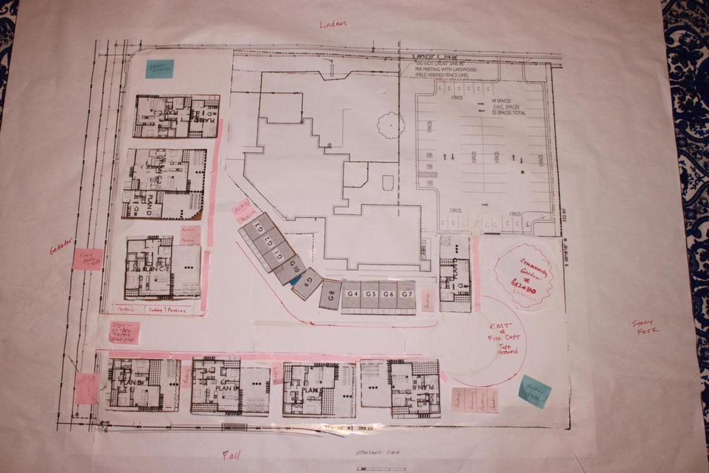
6 Garages 1-7 will access the site via Fall Drive and garages 8-12 will access the site via Linden Street. 5 DRAFT PUD
7 4. Driveways 4.1 Linden Street a. Existing Conditions: There is currently one driveway from the Lakewood Montessori School parking lot onto Linden Street, located approximately 95 feet east of Waterbury Lane on the north side of Linden Street and 385 feet east of the intersection of Gekeler Lane and Linden Street. b. Policy: Access Policy: District Policy states that all access points associated with development applications shall be determined in accordance with the policies in this section and Section Access points shall be reviewed only for a development application that is being considered by the lead land use agency. Approved access points may be relocated and/or restricted in the future if the land use intensifies, changes, or the property redevelops. District Policy states that the primary function of a collector is to intercept traffic from the local street system and carry that traffic to the nearest arterial. A secondary function is to service adjacent property. Access will be limited or controlled. Collectors may also be designated at bicycle and bus routes. Driveway Location Policy (Stop Controlled Intersection): District policy requires driveways located on collector roadways near a STOP controlled intersection to be located outside of the area of influence; OR a minimum of 150-feet from the intersection, whichever is greater. Dimensions shall be measured from the centerline of the intersection to the centerline of the driveway. Successive Driveways: District policy Table 1, requires driveways located on collector roadways with a speed limit of 25 MPH and daily traffic volumes greater than 200 VTD to align or offset a minimum of 245-feet from any existing or proposed driveway. Driveway Width Policy: District policy restricts high-volume driveways (100 VTD or more) to a maximum width of 36-feet and low-volume driveways (less than 100 VTD) to a maximum width of 30-feet. Curb return type driveways with 30-foot radii will be required for high-volume driveways with 100 VTD or more. Curb return type driveways with 15-foot radii will be required for low-volume driveways with less than 100 VTD. Driveway Paving Policy: Graveled driveways abutting public streets create maintenance problems due to gravel being tracked onto the roadway. In accordance with District policy, , the applicant should be required to pave the driveway its full width and at least 30- feet into the site beyond the edge of pavement of the roadway and install pavement tapers in accordance with Table 2 under District Policy Minor Improvements Policy: District Policy states that minor improvements to existing streets adjacent to a proposed development may be required. These improvements are to correct deficiencies or replace deteriorated facilities. Included are sidewalk construction or replacement; curb and gutter construction or replacement; replacement of unused driveways with curb, gutter and sidewalk; installation or reconstruction of pedestrian ramps; pavement repairs; signs; traffic control devices; and other similar items. c. Applicant s Proposal: The applicant has a shared access agreement with the Lakewood Montessori School and is proposing to have 5 residential units access Linden Street using this existing driveway. d. Staff Comments/Recommendations: Although the existing driveway does not meet offset requirements from other access on Linden Street, staff recommends a modification of policy to allow the driveway to remain in its current location. The driveway is already constructed and currently serves the school. This development will generate minimal traffic as only 5 units will 6 DRAFT PUD
8 have access to this driveway. Furthermore, the private streets north of Linden Street serve Oakhurst Townhouses and do not generate a large amount of traffic. 4.2 Gekeler Lane a. Existing Conditions: There are two existing driveways on Gekeler Lane: one 10 foot wide driveway located approximately 35 feet north of Fall Drive; and one 24 foot wide driveway on located approximately 130 feet north of Fall Drive. b. Policy: Access Policy: District Policy states that all access points associated with development applications shall be determined in accordance with the policies in this section and Section Access points shall be reviewed only for a development application that is being considered by the lead land use agency. Approved access points may be relocated and/or restricted in the future if the land use intensifies, changes, or the property redevelops. District Policy states that the primary function of a collector is to intercept traffic from the local street system and carry that traffic to the nearest arterial. A secondary function is to service adjacent property. Access will be limited or controlled. Collectors may also be designated at bicycle and bus routes. Driveway Location Policy (Stop Controlled Intersection): District policy requires driveways located on collector roadways near a STOP controlled intersection to be located outside of the area of influence; OR a minimum of 150-feet from the intersection, whichever is greater. Dimensions shall be measured from the centerline of the intersection to the centerline of the driveway. Successive Driveways: District policy Table 1, requires driveways located on collector roadways with a speed limit of 20 MPH and daily traffic volumes greater than 200 VTD to align or offset a minimum of 245-feet from any existing or proposed driveway. Driveway Width Policy: District policy restricts high-volume driveways (100 VTD or more) to a maximum width of 36-feet and low-volume driveways (less than 100 VTD) to a maximum width of 30-feet. Curb return type driveways with 30-foot radii will be required for high-volume driveways with 100 VTD or more. Curb return type driveways with 15-foot radii will be required for low-volume driveways with less than 100 VTD. Driveway Paving Policy: Graveled driveways abutting public streets create maintenance problems due to gravel being tracked onto the roadway. In accordance with District policy, , the applicant should be required to pave the driveway its full width and at least 30- feet into the site beyond the edge of pavement of the roadway and install pavement tapers in accordance with Table 2 under District Policy Minor Improvements Policy: District Policy states that minor improvements to existing streets adjacent to a proposed development may be required. These improvements are to correct deficiencies or replace deteriorated facilities. Included are sidewalk construction or replacement; curb and gutter construction or replacement; replacement of unused driveways with curb, gutter and sidewalk; installation or reconstruction of pedestrian ramps; pavement repairs; signs; traffic control devices; and other similar items. c. Applicant s Proposal: The applicant is proposing to close the 10 foot wide driveway and use the 24 foot wide existing driveway to provide access from the development onto Gekeler Lane. The applicant is proposing to reduce the driveway width to 20 feet. d. Staff Comments/Recommendations: The applicant's proposal does not meet District Access Management, Successive Driveway, and Driveway Location Policies and should not be approved as proposed. Staff recommends the applicant close both existing driveways onto Gekeler Lane and use Fall Drive to access the site. Fall Drive is a local street and therefore 7 DRAFT PUD
9 has a lesser classification than Gekeler Lane. Additionally, only 7 units will be using this access point which will generate minimal traffic. 4.3 Fall Drive a. Existing Conditions: There are no existing driveways constructed from the site onto Fall Drive. b. Policy: Driveway Location Policy: District policy requires driveways located near intersections to be located a minimum of 75-feet (measured centerline-to-centerline) from the nearest street intersection. Successive Driveways: District Policy states that successive driveways away from an intersection shall have no minimum spacing requirements for access points along a local street, but the District does encourage shared access points where appropriate. Driveway Width Policy: District policy states that where vertical curbs are required, residential driveways shall be restricted to a maximum width of 20-feet and may be constructed as curb-cut type driveways. Driveway Paving Policy: Graveled driveways abutting public streets create maintenance problems due to gravel being tracked onto the roadway. In accordance with District policy, , the applicant should be required to pave the driveway its full width and at least 30-feet into the site beyond the edge of pavement of the roadway. c. Applicant s Proposal: The applicant is proposing to construct one 20 foot wide driveway onto Fall Drive, located approximately 150 feet east of the intersection of Fall Drive and Gekeler Lane. d. Staff Comments/Recommendations: The applicant s proposal meets District Policy and should be approved as proposed. The applicant should be required to pave the driveway its entire width and 30 feet into the site beyond the edge of pavement of Fall Drive. 5. Tree Planters Tree Planter Policy: Tree Planter Policy: The District s Tree Planter Policy prohibits all trees in planters less than 8-feet in width without the installation of root barriers. Class II trees may be allowed in planters with a minimum width of 8-feet, and Class I and Class III trees may be allowed in planters with a minimum width of 10-feet. 6. Landscaping Landscaping Policy: A license agreement is required for all landscaping proposed within ACHD right-of-way or easement areas. Trees shall be located no closer than 10-feet from all public storm drain facilities. Landscaping should be designed to eliminate site obstructions in the vision triangle at intersections. District Policy requires a 40-foot vision triangle and a 3-foot height restriction on all landscaping located at an uncontrolled intersection and a 50-foot offset from stop signs. Landscape plans are required with the submittal of civil plans and must meet all District requirements prior to signature of the final plat and/or approval of the civil plans. 7. Other Access Linden Street and Gekeler Lane are classified as collector roadways. Other than the access specifically approved with this application, direct lot access is prohibited to these roadways and should be noted on the final plat. 8 DRAFT PUD
10 8. Neighborhood Concerns This application is on the regular agenda due to neighborhood concerns. Correspondence that has been received prior to December 2, 2013 is included with this staff report. Neighborhood concerns include: Parking on Fall Drive and Stony Fork Way o o o Concern: Residents are concerned about adequate on-site parking for the residents in the proposed 12 unit PUD, and the potential for those residents to park on Fall Drive and/or Stony Fork Way. Residents don t want parking restrictions on those streets, however, because they utilize on-street parking. Proposal: The applicant is constructing 16 wide garages. Half of the garage will have structured storage (cabinets, shelves, etc ) and the other half will be a parking bay that will include a mechanical lift so that two cars can be parked inside, one stacked above the other. Four visitor parking spaces are provided off of the driveway that serves 7 units, and the applicant is sharing a parking lot with the adjacent Montessori school via a shared parking agreement. Staff comment: The site does not have frontage on Stony Fork Way (see attached vicinity map). It is very unlikely that residents or guests would park down the road and walk to the site when there is parking available within the parking lot, garages, or designated visitor parking. Staff recommends that NO PARKING signs be installed on Fall Drive adjacent to the site, and for the first 50 on the south side of the street. This will not restrict parking in front of residences. The City determines the amount of parking that is required with a development application. Access on to Fall Drive o Concern: Residents are concerned about the additional traffic in the neighborhood. o Proposal: The applicant proposed access to Fall Drive, in accordance with ACHD Policy. The Fall Drive access will serve 7 units and the Linden Street access will serve 5 units. o Staff comment: The total traffic projected to be generated from this development is 70 VTD, and 6 trips in the PM peak hour. ACHD conducted a traffic count on Wednesday, November 20, There were 290 daily vehicle trips and 22 vehicle trips in the peak hour. The standard threshold for local streets is 2,000 VTD. D. Site Specific Conditions of Approval 1. Correct deficiencies and replace deteriorated facilities on Linden Street, Gekeler Lane and Fall Drive abutting the site, including sidewalk, curb, gutter and pedestrian ramps. 2. Obtain a license agreement for the existing landscaping and sidewalk on Linden Street that is located outside of the right-of-way. 3. Construct a 5 foot wide concrete sidewalk on Fall Drive abutting the site. The sidewalk may be detached to avoid the tree. Install pedestrian ramps at the Fall Drive/Gekeler Lane intersection. 4. Install No Parking signs on Fall Drive abutting the site, and on the south side, from Gekeler Lane, 50 feet to the east. 5. The existing driveway on Linden Street is approved. 6. Close the two existing driveways on Gekeler Lane with curb, gutter and sidewalk. 9 DRAFT PUD
11 7. Construct one 20 foot wide driveway on Fall Drive, located 150 feet east of Gekeler Lane. Pave the driveway its entire width and at least 30 feet into the site beyond the edge of pavement. 8. Other than the access specifically approved with this application, direct lot access to Linden Street and Gekeler Lane is prohibited and shall be noted on the final plat. 9. Payment of impacts fees are due prior to issuance of a building permit. 10. Comply with all Standard Conditions of Approval. E. Standard Conditions of Approval 1. All irrigation facilities shall be relocated outside of the ACHD right-of-way. 2. Private Utilities including sewer or water systems are prohibited from being located within the ACHD right-of-way. 3. In accordance with District policy, , the applicant may be required to update any existing non-compliant pedestrian improvements abutting the site to meet current Americans with Disabilities Act (ADA) requirements. The applicant s engineer should provide documentation of ADA compliance to District Development Review staff for review. 4. Replace any existing damaged curb, gutter and sidewalk and any that may be damaged during the construction of the proposed development. Contact Construction Services at (with file number) for details. 5. A license agreement and compliance with the District s Tree Planter policy is required for all landscaping proposed within ACHD right-of-way or easement areas. 6. All utility relocation costs associated with improving street frontages abutting the site shall be borne by the developer. 7. It is the responsibility of the applicant to verify all existing utilities within the right-of-way. The applicant at no cost to ACHD shall repair existing utilities damaged by the applicant. The applicant shall be required to call DIGLINE ( ) at least two full business days prior to breaking ground within ACHD right-of-way. The applicant shall contact ACHD Traffic Operations in the event any ACHD conduits (spare or filled) are compromised during any phase of construction. 8. Utility street cuts in pavement less than five years old are not allowed unless approved in writing by the District. Contact the District s Utility Coordinator at (with file numbers) for details. 9. All design and construction shall be in accordance with the ACHD Policy Manual, ISPWC Standards and approved supplements, Construction Services procedures and all applicable ACHD Standards unless specifically waived herein. An engineer registered in the State of Idaho shall prepare and certify all improvement plans. 10. Construction, use and property development shall be in conformance with all applicable requirements of ACHD prior to District approval for occupancy. 11. No change in the terms and conditions of this approval shall be valid unless they are in writing and signed by the applicant or the applicant s authorized representative and an authorized representative of ACHD. The burden shall be upon the applicant to obtain written confirmation of any change from ACHD. 12. If the site plan or use should change in the future, ACHD Planning Review will review the site plan and may require additional improvements to the transportation system at that time. Any change in the planned use of the property which is the subject of this application, shall require the applicant to comply with ACHD Policy and Standard Conditions of Approval in place at that time unless a waiver/variance of the requirements or other legal relief is granted by the ACHD Commission. 10 DRAFT PUD
12 F. Conclusions of Law 1. The proposed site plan is approved, if all of the Site Specific and Standard Conditions of Approval are satisfied. 2. ACHD requirements are intended to assure that the proposed use/development will not place an undue burden on the existing vehicular transportation system within the vicinity impacted by the proposed development. G. Attachments 1. Vicinity Map 2. Site Plan 3. Neighborhood Correspondence 4. Utility Coordinating Council 5. Development Process Checklist 6. Request for Reconsideration Guidelines 11 DRAFT PUD

13 VICINITY MAP 12 DRAFT PUD

14 SITE PLAN 13 DRAFT PUD
15 NEIGHBORHOOD CORRESPONDENCE Good Afternoon Mindy, I wanted to share my concerns about the planned updates to Fall Drive in Boise, Currently, I resided just after the corner of Fall Drive, on Stony Fork Way. I'm concerned with the traffic revision that would open up a new housing community to access Fall Drive. My main concern is the additional traffic from residents coming and going. In addition, Fall Drive being the 'overflow' parking for the housing development. My Husband and I have a young child and any time I hear increased traffic my main concern is her safety. The traffic leaving the development will be going to Gekeler Lane or to Stony Fork - this is right at our community park where children are usually congregating. Children in our community, in general, are riding bikes, crossing the streets to get to the park and using the sidewalks extensively. Being children, they occasionally make childish decisions. The increased traffic multiplies the opportunities for an accident between the them. My second concern with the access on Fall Drive is the corner. As it stands, the corner of Fall Drive and Gekeler Lane does not have a sidewalk. Additional access cuts off safe pedestrian access to Geckler Lane. People wanting to access Geckler will have to 'cut through' the new development's drive or walk around. This seems an easy task for a fit adult, but for some of the older folks in our community using the sidewalks, it poses trouble for getting around the corner. I'm not going to be able to addend any of the ACHD planned meetings in person to support my feelings. I'm doing a round of chemo and my doctor has requested I say home for the duration. Please don't my absence at meetings as a lack of concern. Thanks for your time today. Sincerely, Christina Faul 2729 S. Stony Fork Way Bosie, ID DRAFT PUD
16 Dear Ms. Watsek, We are residents in the Lakewood neighborhood that s adjacent to the proposed development planned for E. Gekeler Lane, E. Fall Dr. and E. Linden St. in southeast Boise. We're writing to bring a few of our concerns to your attention regarding this project. We recognize that development of the property at the corner of Gekeler Lane and Linden is inevitable. We're in favor of enhancements to our community that support existing home values, complement the vision of the Lakewood development and strengthen our tax base. However, this proposed project includes parking in our neighborhood on E. Fall Dr. The proposed project should have ample parking of its own within its own lot. The proposed project also includes access off of E. Fall Dr. As parents of two girls, aged 9 and 11, we worry about the safety issue it presents for our children due to the added traffic load on adjacent streets. They play in the park at the end of E. Fall Road, as well as near the ponds off of E. Fall Dr. I recommend that access be focused on S. Gekeler Ln. and E. Linden St. And if a loop has to be incorporated that empties on to E. Fall Dr. for emergency purposes, I recommend that an emergency gate be added to the project as to avoid through-traffic on E. Fall Dr. Thank you for your time and if you have any questions, you can reach us at Respectfully Yours, Doug and Suzanne Metzgar 2809 South Falling Brook Way -- Thank you. Doug Metzgar DRAFT PUD
17 Reference: Deep Green Housing (DGH) Project at Linden and Gekeler in Boise Commissioner Mitchell Jaurena, The Lakewood Homeowners living in closest proximity (12 closest households) have concerns about the exit from Deep Green Housing (DGH) onto E. Fall Drive into the Lakewood subdivision. a) Currently cars come around the blind turn on Fall Drive headed towards Gekeler as cars are turning left off Gekeler onto Fall. To add an egress driveway onto E. Fall Drive in the middle of that activity and congestion in a subdivision would increase the probability of accidents. b) Covenants of Lakewood HOA do not allow street parking and with easy access into the DGH development through the exit on E. Fall Drive, street parking will increase in Lakewood. We would like to suggest the elimination of the curb cut on E. Fall Drive, eliminating a portion of the one-way site driveway in the proposed DGH plans. The gained site square footage would allow site redesign to add additional guest parking, a turnaround space and increase drive isle width. In the current plan, minimal guest parking exists at the west end of the project. Residents at that end of the site would benefit from increased close guest parking, thus reducing parking on E. Fall Drive. The Gekeler curb cut and drive isle width could be increased to accommodate vehicle entry and exit. This would increase vehicle maneuverability when entering the site at the same time garage exits are occurring. Currently there are curb cuts onto Gekeler from the Montessori School parking lot. The volume of vehicles onto Gekeler from DGH will decrease substantially with the Montessori School parking moved to the Linden side. The garages located at the east side of the development have one entry / exit point. The Gekeler entry / exit would be similar. To recap, the Lakewood Subdivision Homeowners in the above mentioned group would like consideration of removing E. Fall Drive access from DGH. Doing this will address the following Lakewood Homeowners concerns: Less parking congestion (DGH residents and guests) on E. Fall Drive Address the additional traffic in a subdivision at a blind turn Address the Lakewood Covenants that do not allow street parking Keep DGH a closed development and not a part of Lakewood Subdivision Thank you for taking time to consider our concerns addressed above. If you have questions, please contact either Brad or Kelli Bolicek at or boloidaho@msn.com. Brad and Kelli Bolicek 173 E. Fall Drive Boise, Idaho DRAFT PUD
18 Dear Ms. Watsek, I am a Lakewood resident of nearly 25 years. It has been a pleasure to live in a well planned community. The proposed Deep Green Homes project will impact Lakewood negatively as it provides no street parking for residents and impractical garages. People tend to do what is easiest. It will not be easy using tandem hydraulic garages. Residents will look for the easiest place to park when the tandem garage isn t practical, which for most of the homes in the Deep Green development will be Fall Drive and Stoney Fork. Even if Fall Drive and Stoney Fork are posted No Parking, I can imagine dozens of scenarios where one car needs to move out of the garage so the other car can come out or both residents are coming home after work, one is in the garage unloading groceries and the other car needs a place to rest until they can tandem. They will seek the easiest solution and will park on Fall Drive or Stoney Fork temporarily. This will be impossible to enforce. If the Fall Drive exit is blocked to cars, but provides walking access, the problem remains. Another option for Deep Green residents will be to park on Fall Drive on the west side of Gekeler and then cross the street (there is no crosswalk at this intersection.) Again this will negatively impact Lakewood with Deep Green residents parking in the Lakewood neighborhood. The Deep Green development is too crowded and does not provide street parking or adequate garages for practical use. In addition, the tandem garages will create more traffic in and out of the development than a traditional development would. Since there is no street parking in the development there will be much more starting of cars and moving cars in and out of the development as residents try to shuffle their vehicles to figure out their day and which cars will be available at which times. My hope is the Deep Green will configure their development to provide what is needed for people to live comfortably: street parking and adequate practical garages. Constantly moving cars and looking for street parking outside the development do not provide for practical green living. Constantly starting cars and moving cars creates extra pollution and extra traffic on surrounding streets. Secondly my hope is that Deep Green will not have a driveway emptying onto Fall Drive which may best ameliorate the neighborhood concerns about parking on Fall Drive and Stoney Fork. Thank you for considering the impact of Deep Green Housing development at Linden and Gekeler on the Lakewood planned community. Sarah Connolly 2750 S. Falling Brook Way DRAFT PUD
19 2693 South Stoney Fork Way Boise, Idaho November 21, 2013 Mindy Wallace Planner III Ada County Highway District RE: High Density Building Proposal from Deep Green Homes, Integra (Non-Profit) Foundation Dear Ms. Wallace: We are writing to share our concerns about the Deep Green Housing (DGH) high-density housing project proposed for construction on the corner of Gekeler and Linden. We have lived in our home for 29 years, have raised our family and buried our pets at this location. We chose this home for three reasons: 1) Because we had no neighbors behind us except a parking lot attached to a church activity was predominantly a once-a-week occurrence; and 2) Most homes in our neighborhood are built on ¼ acre lots providing ample space for privacy and 3)The Lakewood community was the first planned neighborhood with CC&Rs and intentionally designed with open spaces, walkways, ponds, and parks providing for quiet family living. While we recognize and accept that change is not something we can stop or prevent, we remain hopeful that ACHD will not permit traffic & parking changes to come to this neighborhood that will negatively impact our community s design and flow. The Tate family originally donated the 4-acre parcel for the purpose of a community church. Some 25 years later, that church was sold and converted into a Montesorri School (utilizing about 2 acres). The remaining property is proposed to be a high-density housing project in the midst of a preschool that serves 150 toddlers and preschoolers - we believe that to be nothing less than an unfortunate and hazardous mistake. We ask that the ACHD Commissions carefully consider the impact that their decision will have on our neighborhood and the Montesorri school children forever. As mentioned earlier, we don't object to the concept of a subdivision as a whole, we would hope that you and the Commission can see that modifications are needed to ensure the transition from the Lakewood development to DGH is more compatible. Please know that we have attempted in good faith to communicate with the developer, Mr. Gary Christensen in hopes that we could discuss our concerns face-to-face and that he would relate with our concerns (as he was a neighbor in Lakewood years ago) and subsequently make the needed adjustments. Unfortunately, Mr. Christensen rebuffed our requests to meet. Hence, we write to you today to communicate our traffic and parking concerns (only) summarized below: Parking and Traffic Concerns DGH plans to build 12 detached two-car garages with hydraulic stacking lifts. The lifts are claimed as the primary parking source for residents. Mr. Christensen plans to share the Montesorri School parking lot with the planned cluster garage units (with stacking car lifts) and guest parking for his high-density subdivision. This plan creates a mixed-use competition in the parking lot for residents who are leaving/arriving to and from work/school etc., and parents dropping off and picking up their preschoolers we believe this is a recipe for disaster and creates a serious safety concern. The stacking car lifts and cluster garages might be good plan for downtown 18 DRAFT PUD
20 Manhattan, but it is clearly not practical with normal everyday life activities in this neighborhood. Where do guests park, where do residents park to unload groceries or delivery or emergency services park? Residents of DGH will look to park their vehicle in areas that are closer to their front door, i.e. Fall Drive and Stony Fork Way. Lakewood CCR s do not allow for parking on the streets consequently any overflow parking on Fall Drive and Stony Fork Way. This will have a negative impact on the adjacent neighborhood. o We propose a concrete parking restriction plan be spelled out by the developer to ensure there is no spill-over parking into adjacent neighborhoods through specific signage, covenant or CCR s. o In addition, we know that the simple practical action would be to sign these streets to disallow parking on the streets. However, Lakewood residents do utilize street parking for guests and deliveries, etc.; therefore, we would request that any signage take these needs into consideration. Approximately cars enter and exit onto Gekeler twice a day as parents drop off and pick up children at the school. The new project will move Montessori traffic on to Linden. o o Traffic from the new project with homes would be 60% less than the current traffic flow onto Gekeler, therefore making it practical and logical for Gekeler to be utilized as the only access road into DGH subdivision instead of directing traffic on to Fall Drive. We recommend an exception to ACHD policy to direct traffic from subdivisions onto secondary roads because the traffic from DGH will be less than the current traffic into and out of the Montessori School. We are concerned that the incompatibility of the two developments due to reasons outlined above will have a negative impact on our property and the privacy that we have enjoyed in this neighborhood for many years. A modification of the design would make the proposed project more acceptable to us and our neighbors. Thank you very much for your consideration of our concerns and request. Sincerely, Chet and Debi Alvord cc: ACHD Commissioners 19 DRAFT PUD
21 Dear Mindy, We wanted to make a quick addition to the we sent you yesterday re: the Deep Green Homes (DGH) high density development in SE Boise submitted by the non-profit foundation, the Integra Foundation. We ask that this be part of the record for this request. First, let us apologize for the non-technical terms we use in this in an attempt to describe our request - it's really obvious we are not engineers! :-) That said, we would like to clarify our proposal that instead of allowing a loop entrance/exit on Fall Dr and Gekeler Lane, that an exception be allowed to the Policy Manual that permits the continuation of the existing entrance/exit on Gekeler Lane with no access on to Fall. An alternate design (I will forward this to you in a separate ) was shared with the developer (as a starting place to consider other options) that incorporated a dead-end lane running from Gekeler to a round-about at the opposite end or East side of the property (another benefit to this option provided space to move the infrastructure needs such as garage access & parking to the interior of the development). The current entrance/exit on Gekeler Ln serves the Montessori School with approximately 30 or 40 cars dropping off in the morning. The building plans move the Montessori School access to Linden Street (which is an even busier street than Gekeler Ln). Once this change occurs, we calculate an approximate 60% reduction in traffic from the DGH development (vs the Montessori School serving 150 pre-schoolers) on to Gekeler Ln (bc this would only serve the 5 or 6 garage units planned for the SW corner of this development). This traffic impact reduction will hopefully make an exception possible and viewed as a practical win/win solution. However, if an access on Fall Dr is mandated, we would ask that it be designated as an emergency entrance only & that a gate be installed similar to other subdivisions in Boise (we will send you a photo of an example in a separate ). We hope you can understand the value this exception would bring to the adjacent neighbors on (East) Fall Dr by reducing additional traffic on this already narrow street. We will be sending you the photos mentioned above in hopes it may enhance your understanding of our request (we ask that you add it to the official record). Thank you for your time & consideration in this important neighborhood decision. Sincerely, Debi & Chet Alvord 2693 S Stoney Fork Way DRAFT PUD

22 Dear Mindy, As promised, attached are the photo exhibits we'd like to submit for the hearing scheduled for Dec 11th at noon regarding the Deep Green Homes high density development proposed for SE Boise on the corners of Gekeler and Linden and Fall Drive. Unfortunately, we won't be able to attend this meeting as we will be out of town. However, we did previously submit a letter (via ) and an additional clarification regarding this project proposal. As I'm sure you can tell, we are very passionate about how this proposal will impact and change our neighborhood forever. If you could print or share these photos and this for the commissioners' review, we would greatly appreciate it. Sincerely, Debi & Chet Alvord 21 DRAFT PUD
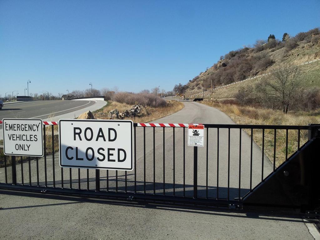
23 22 DRAFT PUD
24 Ada County Utility Coordinating Council Developer/Local Improvement District Right of Way Improvements Guideline Request Purpose: To develop the necessary avenue for proper notification to utilities of local highway and road improvements, to help the utilities in budgeting and to clarify the already existing process. 1) Notification: Within five (5) working days upon notification of required right of way improvements by Highway entities, developers shall provide written notification to the affected utility owners and the Ada County Utility Coordinating Council (UCC). Notification shall include but not be limited to, project limits, scope of roadway improvements/project, anticipated construction dates, and any portions critical to the right of way improvements and coordination of utilities. 2) Plan Review: The developer shall provide the highway entities and all utility owners with preliminary project plans and schedule a plan review conference. Depending on the scale of utility improvements, a plan review conference may not be necessary, as determined by the utility owners. Conference notification shall also be sent to the UCC. During the review meeting the developer shall notify utilities of the status of right of way/easement acquisition necessary for their project. At the plan review conference each company shall have the right to appeal, adjust and/or negotiate with the developer on its own behalf. Each utility shall provide the developer with a letter of review indicating the costs and time required for relocation of its facilities. Said letter of review is to be provided within thirty calendar days after the date of the plan review conference. 3) Revisions: The developer is responsible to provide utilities with any revisions to preliminary plans. Utilities may request an updated plan review meeting if revisions are made in the preliminary plans which affect the utility relocation requirements. Utilities shall have thirty days after receiving the revisions to review and comment thereon. 4) Final Notification: The developer will provide highway entities, utility owners and the UCC with final notification of its intent to proceed with right of way improvements and include the anticipated date work will commence. This notification shall indicate that the work to be performed shall be pursuant to final approved plans by the highway entity. The developer shall schedule a preconstruction meeting prior to right of way improvements. Utility relocation activity shall be completed within the times established during the preconstruction meeting, unless otherwise agreed upon. Notification to the Ada County UCC can be sent to: 50 S. Cole Rd. Boise 83707, or Visit iducc.com for notification information. 23 DRAFT PUD
25 Items Completed to Date: Development Process Checklist Submit a development application to a City or to Ada County The City or the County will transmit the development application to ACHD The ACHD Planning Review Section will receive the development application to review The Planning Review Section will do one of the following: Send a No Review letter to the applicant stating that there are no site specific conditions of approval at this time. Write a Staff Level report analyzing the impacts of the development on the transportation system and evaluating the proposal for its conformance to District Policy. Write a Commission Level report analyzing the impacts of the development on the transportation system and evaluating the proposal for its conformance to District Policy. Items to be completed by Applicant: For ALL development applications, including those receiving a No Review letter: The applicant should submit one set of engineered plans directly to ACHD for review by the Development Review Section for plan review and assessment of impact fees. (Note: if there are no site improvements required by ACHD, then architectural plans may be submitted for purposes of impact fee assessment.) The applicant is required to get a permit from Construction Services (ACHD) for ANY work in the right-ofway, including, but not limited to, driveway approaches, street improvements and utility cuts. Pay Impact Fees prior to issuance of building permit. Impact fees cannot be paid prior to plan review approval. DID YOU REMEMBER: Construction (Non-Subdivisions) Driveway or Property Approach(s) Submit a Driveway Approach Request form to ACHD Construction (for approval by Development Services & Traffic Services). There is a one week turnaround for this approval. Working in the ACHD Right-of-Way Four business days prior to starting work have a bonded contractor submit a Temporary Highway Use Permit Application to ACHD Construction Permits along with: a) Traffic Control Plan b) An Erosion & Sediment Control Narrative & Plat, done by a Certified Plan Designer, if trench is >50 or you are placing >600 sf of concrete or asphalt. Construction (Subdivisions) Sediment & Erosion Submittal At least one week prior to setting up a Pre-Construction Meeting an Erosion & Sediment Control Narrative & Plan, done by a Certified Plan Designer, must be turned into ACHD Construction to be reviewed and approved by the ACHD Stormwater Section. Idaho Power Company Vic Steelman at Idaho Power must have his IPCO approved set of subdivision utility plans prior to Pre-Con being scheduled. Final Approval from Development Services is required prior to scheduling a Pre-Con. 24 DRAFT PUD
BOI / DRH S. 13 th Street Mixed use office/retail development with residential dormitory
 Jim D. Hansen, President Sara M. Baker, Vice President Rebecca W. Arnold, Commissioner Kent Goldthorpe, Commissioner Paul Woods, Commissioner October 21, 2015 To: Rick Nesser ISS River Partners, LLC 8312
BPP / SUB
 Development Services Department Project/File: Lead Agency: Site address: Millwell Place Subdivision/ BPP15-0031/ SUB15-0064 This is a preliminary plat application to allow for the development of 68 building
ACHD Board of Commissioners Stacey Yarrington, Planner III Tandem Ridge/ EPP / PP-07-16/ RZ-12-16/ CPA-01-16/ A-07-16
 Development Services Department DATE: December 14, 2016 TO: FROM: SUBJECT: ACHD Board of Commissioners Stacey Yarrington, Planner III Tandem Ridge/ EPP16-0012/ PP-07-16/ Executive Summary: This is an annexation,
Development Services Department
 Kent Goldthorpe, President Paul Woods, Vice President Rebecca W. Arnold, Commissioner Sara M. Baker, Commissioner Jim D. Hansen, Commissioner July 21, 2016 Development Services Department To: From: ACHD
 Development Services Department Project/File: Lead Agency: Site address: Aralar Park/SUB13-00048 This is a preliminary plat application to construct 55 buildable lots and 6 common lots on 12.67 acres.
 Development Services Department Project/File: Lead Agency: Site address: Fall Creek Subdivision (MPP-12-016) This is a preliminary plat application to subdivision approximately 110 acres into 296 residential
BPP / SUB /CAR /PUD
 Development Services Department Project/File: Lead Agency: Site address: Roe Street Townhomes/ BPP16-0023/ SUB16-00046/CAR16-00023/PUD16-00022 This is a rezone, preliminary plat, and planned unit development
Committed to Service. Development Services. February 21, ACHD Commission. Mindy Wallace, AICP
 Committed to Service Sara M. Baker, President Rebecca W. Arnold, Vice President Jim D. Hansen, Commissioner Kent Goldthorpe, Commissioner Paul Woods, Commissioner February 21, 2018 Development Services
 Development Services Department Project/File: Lead Agency: Site address: Applicant: Memory Ranch / KPP15-0003 / 15-02-AN / 15-01-S The applicant is requesting annexation of approximately 10 acres, rezoning
Development Services Department
 Kent Goldthorpe, President Paul Woods, Vice President Rebecca W. Arnold, Commissioner Sara M. Baker, Commissioner Jim D. Hansen, Commissioner July 28, 2016 Development Services Department To: From: ACHD
Committed to Service
 Committed to Service Sara M. Baker, President Rebecca W. Arnold, Vice President Jim D. Hansen, Commissioner Kent Goldthorpe, Commissioner Paul Woods, Commissioner February 21, 2018 Development Services
Roadway Classification Design Standards and Policies. Pueblo, Colorado November, 2004
 Roadway Classification Design Standards and Policies Pueblo, Colorado November, 2004 Table of Contents Page Chapter 1. General Provisions 1.1 Jurisdiction 3 1.2 Purpose and Intent 3 1.3 Modification 3
Committed to Service
 Development Services Department Committed to Service January 19, 2016 TO: FROM: SUBJECT: ACHD Board of Commissioners Mindy Wallace, AICP Planner III Kirsten Subdivision/BPP15-0023 Executive Summary: The
Committed to Service
 Development Services Department Committed to Service June 30, 2014 TO: FROM: SUBJECT: ACHD Board of Commissioners Christy Little Planning Review Supervisor Victory Middle School/MCUP-14-003 DATE: July
Committed to Service
 Committed to Service Paul Woods, President Rebecca W. Arnold, Vice President Sara M. Baker, Commissioner Jim D. Hansen, Commissioner Kent Goldthorpe, Commissioner September 19, 2017 Development Services
Committed to Service
 Committed to Service Paul Woods, President Rebecca W. Arnold, Vice President Sara M. Baker, Commissioner Jim D. Hansen, Commissioner Kent Goldthorpe, Commissioner January 16, 2018 Development Services
2. Caven Ridge Estates Subdivision No. 1 adds 0.54 centerline miles to the ACHD roadway system.
 Kent Goldthorpe, President Paul Woods, Vice President Rebecca W. Arnold, Commissioner Sara M. Baker, Commissioner Jim D. Hansen, Commissioner October 12, 2016 Development Services Department To: From:
ADA Transition Plan. City of Gainesville FY19-FY28. Date: November 5, Prepared by: City Of Gainesville Department of Mobility
 ADA Transition Plan FY19-FY28 Date: November 5, 2018 Prepared by: City Of Gainesville Department of Mobility 1.0 INTRODUCTION 1.1 BACKGROUND The federal statute known as the Americans with Disabilities
Committed to Service
 Committed to Service Kent Goldthorpe, President Paul Woods, Vice President Rebecca W. Arnold, Commissioner Sara M. Baker, Commissioner Jim D. Hansen, Commissioner May 24, 2017 Development Services TO:
COUNTY OF SONOMA PERMIT AND RESOURCE MANAGEMENT DEPARTMENT 2550 Ventura Avenue, Santa Rosa, CA (707) FAX (707)
 FAX (707)") COUNTY OF SONOMA PERMIT AND RESOURCE MANAGEMENT DEPARTMENT 2550 Ventura Avenue, Santa Rosa, CA 95403 (707) 565-1900 FAX (707) 565-1103 DATE: February 17, 2012 TO: Board of Supervisors FROM: Blake Hillegas,
COUNTY OF SONOMA PERMIT AND RESOURCE MANAGEMENT DEPARTMENT 2550 Ventura Avenue, Santa Rosa, CA 95403 (707) 565-1900 FAX (707) 565-1103 DATE: February 17, 2012 TO: Board of Supervisors FROM: Blake Hillegas,
Access requests to County streets and roadways are processed through one of the following methods:
 13.1 GENERAL APPLICATION PROCESS Access requests to County streets and roadways are processed through one of the following methods: A. Planned Developments may set general locations for access points.
Street Paving and Sidewalk Policy
 City Commission Policy 600 Street Paving and Sidewalk Policy DEPARTMENT: Public Works DATE ADOPTED: June 7, 1995 DATE OF LAST REVISION: December 10, 2014 Policy No. 600.01 AUTHORITY: PASS City of Tallahassee-Leon
SECTION 3 STREET DESIGN
 3.01 GENERAL SECTION 3 STREET DESIGN For purposes of geometric and structural design, streets shall be classified according to the following table. The City Engineer will determine the class of all proposed
Subdivision Staff Report
 Subdivision Staff Report Subdivision Name Plano Road Subdivision File Number SUB07-00065 Approval Preliminary Plat Lead Agency Boise City Annexation Date Pending (CAR07-00042/DA) Comp. Plan Does Not Comply
Development Services Department
 Development Services Department Project/File: Lead Agency: Site address: Harris Ranch Specific Area Plan Text Amendments/ZOA14-00001 The applicant is requesting approval of a text amendment application
INTRODUCTION THOROUGHFARE SYSTEM CLASSIFICATIONS
 INTRODUCTION The thoroughfare plan will assist public officials in the development of a specialized system for efficient and safe movement of vehicular traffic while minimizing potential conflicts with
Committed to Service
 Development Services Department Committed to Service TO: FROM: Ada County Highway District Commissioners Mindy Wallace, AICP Planner III COMISSION HEARING: January 27, 2016 SUBJECT: Syringa Valley Specific
NEW BUSINESS CITY PLANNING COMMISSION AGENDA ITEM NO: 4 STAFF: STEVE TUCK FILE NO: CPC UV QUASI-JUDICIAL
 Page 47 NEW BUSINESS CITY PLANNING COMMISSION AGENDA ITEM NO: 4 STAFF: STEVE TUCK FILE NO: CPC UV 08-00154 QUASI-JUDICIAL PROJECT: APPLICANT: OWNER: GENERAL OR MEDICAL OFFICE AT 1730 NORTH CORONA STREET
 COMPLETE STREETS CHECKLIST City of Philadelphia The City of Philadelphia's Complete Streets policies are designed ensure that city streets are safe, comfortable and convenient for people of all ages and
2. The applicant is Corey Barton Homes, Inc. and the principal for the applicant is Corey D. Barton, President.
 Kent Goldthorpe, President Paul Woods, Vice President Rebecca W. Arnold, Commissioner Sara M. Baker, Commissioner Jim D. Hansen, Commissioner February 25, 2016 Development Services Department To: ACHD
TRAFFIC STUDY GUIDELINES Clarksville Street Department
 TRAFFIC STUDY GUIDELINES Clarksville Street Department 9/1/2009 Introduction Traffic studies are used to help the city determine potential impacts to the operation of the surrounding roadway network. Two
This Chapter sets forth the minimum design, technical criteria and specifications to be used in the preparation of all roadway plans.
 4.1 GENERAL This Chapter sets forth the minimum design, technical criteria and specifications to be used in the preparation of all roadway plans. These Roadway Standards are for new construction and modification
Complete Streets. Designing Streets for Everyone. Sarnia
 Complete Streets Designing Streets for Everyone Sarnia Complete Streets ~ Sarnia ~ 2018 Introduction Our City is made up of a network of streets that we use to go for a walk, cycle to work, drive to the
TRAFFIC CALMING GUIDE FOR TORONTO CITY OF TORONTO TRANSPORTATION SERVICES DIVISION
 TRAFFIC CALMING GUIDE FOR TORONTO CITY OF TORONTO TRANSPORTATION SERVICES DIVISION CITY OF TORONTO TRANSPORTATION SERVICES DIVISION 2016 TRAFFIC CALMING GUIDE FOR TORONTO TABLE OF CONTENTS Introduction
Committed to Service
 Development Services Department Committed to Service November 4, 2014 TO: FROM: SUBJECT: ACHD Board of Commissioners Mindy Wallace, AICP Planner III Village Charter School/ BOI14-0105/CUP14-00046/DRH14-000324
County of Greenville South Carolina. Traffic Calming Program Neighborhood Traffic Education Program and Speed Hump Program
 County of Greenville South Carolina Traffic Calming Program Neighborhood Traffic Education Program and Speed Hump Program (rev) August 2008 I. PURPOSE The potential negative impacts from vehicular traffic
State Street and Pierce Park Lane Intersection Concept Report
 State Street and Pierce Park Lane Intersection Prepared for September 2017 Prepared by CITATION Parametrix. 2017. State Street & Pierce Park Lane Intersection. Prepared by Parametrix, Boise, ID. September
Traffic Impact Memorandum. May 22, 2018
 BISHOP PROFESSIONAL DEVELOPMENT BUILDING Proposed Land-use Change & Parking Modification 3601 SW 31st Street Topeka, Kansas 66614 CFS Project No. 185077 Traffic Impact Memorandum May 22, 2018 Prepared
5.0 Roadway System Plan
 Southwest Boise Transportation Study Page 16 5.0 Roadway System Plan The Roadway System Plan outlines roadway improvements in the Initial Study Area. It forecasts future deficiencies on the arterial system,
Driveway Design Criteria
 Design Manual Chapter 5 - Roadway Design 5L - Access Management 5L-4 Driveway Design Criteria A. General For efficient and safe operations, access drives and minor public street intersections can be improved
CHAPTER 16 PEDESTRIAN FACILITIES DESIGN AND TECHNICAL CRITERIA TABLE OF CONTENTS
 CHAPTER 16 PEDESTRIAN FACILITIES DESIGN AND TECHNICAL CRITERIA TABLE OF CONTENTS Section Title Page 16.1 General... 16-1 16.1.1 AASHTO Reference... 16-1 16.1.2 ADA Requirements... 16-1 16.2 Sidewalks...
Town of Siler City - Unified Development Ordinance ARTICLE XIV - Streets and Sidewalks
 ARTICLE XIV - Streets and Sidewalks 193 Street Classification (a) In all new subdivisions, streets that are dedicated to public use shall be classified as provided in 193(b) (1) The classification shall
TRAFFIC IMPACT STUDY CRITERIA
 Chapter 6 - TRAFFIC IMPACT STUDY CRITERIA 6.1 GENERAL PROVISIONS 6.1.1. Purpose: The purpose of this document is to outline a standard format for preparing a traffic impact study in the City of Steamboat
Midway City Council 15 January 2019 Regular Meeting. Homestead Villas / Preliminary Approval
 Midway City Council 15 January 2019 Regular Meeting Homestead Villas / Preliminary Approval CITY COUNCIL MEETING STAFF REPORT DATE OF MEETING: January 15, 2018 NAME OF PROJECT: NAME OF APPLICANT: AGENDA
Town of Mooresville, North Carolina Neighborhood Traffic Calming and Control Device Policy
 Town of Mooresville, North Carolina Neighborhood Traffic Calming and Control Device Policy Adopted January 6, 2014 Town of Mooresville Development Services Department TOWN OF MOORESVILLE NEIGHBORHOOD TRAFFIC
CURBSIDE ACTIVITY DESIGN
 5 CURBSIDE ACTIVITY DESIGN This chapter provides design guidance for separated bike lanes adjacent to curbside activities including parking, loading and bus stops. Typical configurations are presented
ADA TRANSITION PLAN. For
 Page 1 of 7 ADA TRANSITION PLAN For PUBLIC WORKS DEPARTMENT 121 SW Port St. Lucie Boulevard Port St. Lucie, FL 34983 Phone: 772-871-5177 Website: www.cityofpsl.com September 2018 Table of Contents 1) Introduction
TOWN OF PAYSON TRAFFIC CALMING MANUAL
 TOWN OF PAYSON TRAFFIC CALMING MANUAL APPROVED BY THE PAYSON TOWN COUNCIL SEPTEMBER 6, 2007 TOWN OF PAYSON TRAFFIC CALMING POLICY 1.0 Introduction Traffic Calming involves retrofitting physical devices
Access Management Regulations and Standards
 Access Management Regulations and Standards Efficient highway operation Reasonable property access Concept of Access Management The way to manage access to land development while simultaneously preserving
Americans with Disabilities Act Transition Plan for Public Right-of-Way Improvements
 Americans with Disabilities Act Transition Plan for Public Right-of-Way Improvements Prepared by: Public Works Department Engineering Division October 2015 Table of Contents Section I Introduction.. 3
Community Transportation Plan
 Community Transportation Plan Appendix A: Traffic Calming CITY OF DECATUR COMMUNITY TRANSPORTATION PLAN Appendix A: City of Decatur City-wide Residential Traffic Calming Program Process & Procedures The
T A B L E OF C O N T E N T S
 T A B L E OF C O N T E N T S PART III SUBDIVISION REGULATIONS OF THE DEPARTMENT OF PUBLIC WORKS, C & C D PAGE PAGE Responsibility for Development of Streets......... 29 Right-of-Way Widths...... 37 Purpose...........
SECTION TRAFFIC REGULATIONS
 SECTION 01550 TRAFFIC REGULATIONS PART 1 - GENERAL 1.01 OBJECTIVES A. The Contractor shall provide for safe movement of vehicular, bicycle and pedestrian traffic, including persons with disabilities in
Item to be Addressed Checklist Consideration YES NO N/A Required Description Complete Streets Guidelines
 Passaic County Complete Streets Checklist - Concept Development Project Name Item to be Addressed Checklist Consideration YES NO N/A Required Description Complete Streets Guidelines Existing Plans Have
o n - m o t o r i z e d transportation is an overlooked element that can greatly enhance the overall quality of life for the community s residents.
 N o n - m o t o r i z e d transportation is an overlooked element that can greatly enhance the overall quality of life for the community s residents. 84 Transportation CHAPTER 11 INTRODUCTION Transportation
CITY MANUALS AND STANDARDS REVIEW
 GEORGETOWN SIDEWALK MASTER PLAN CITY MANUALS AND STANDARDS REVIEW RESOURCES AND STANDARDS As part of the Master Plan process, a review and evaluation of current City documents and policies relevant to
December 15, City of Ottawa Planning and Growth Management Branch 110 Laurier Ave. W., 4 th Floor Ottawa, ON K1P 1J1
 December 15, 2017 City of Ottawa Planning and Growth Management Branch 110 Laurier Ave. W., 4 th Floor Ottawa, ON K1P 1J1 Attention: Mr. Wally Dubyk, C.E.T. Project Manager, Infrastructure Approvals Dear
Neighborhood Traffic Calming Policy & Guidelines
 Policy & Guidelines Town of Lantana 500 Greynolds Circle Lantana, FL 33462-4594 Index Topic Page Introduction 3 Definitions 4 Objectives 5 Policies 5 Process 6 Phases of Traffic Calming Study 7 Rating
11/28/2016 VIA
 11/28/2016 VIA EMAIL Ethan Meltzer, Assistant Planner City of Sacramento Community Development Department 300 Richards Blvd., 3 rd Floor Sacramento, Ca 95811 RE: Natomas Corporate Center Commercial Building
Chapter 2: Standards for Access, Non-Motorized, and Transit
 Standards for Access, Non-Motorized, and Transit Chapter 2: Standards for Access, Non-Motorized, and Transit The Washtenaw County Access Management Plan was developed based on the analysis of existing
M-58 HIGHWAY ACCESS MANAGEMENT STUDY Mullen Road to Bel-Ray Boulevard. Prepared for CITY OF BELTON. May 2016
 M-58 HIGHWAY ACCESS MANAGEMENT STUDY Prepared for CITY OF BELTON By May 2016 Introduction Missouri State Highway 58 (M-58 Highway) is a major commercial corridor in the City of Belton. As development has
West Dimond Blvd Upgrade Jodhpur Street to Sand Lake Road
 West Dimond Blvd Jodhpur St to Sand Lake CSS Transportation Project Summary Municipality of Anchorage Project # 05 005 Project Manager: John Smith, P.E. (MOA PM&E) Project Administrator: Julie Makela,
Building Great Neighbourhoods BELLEVUE AND VIRGINIA PARK
 Building Great Neighbourhoods BELLEVUE AND VIRGINIA PARK This is Meeting 2 Unfortunately, some residents in Bellevue and Virginia Park received the wrong information for this public open house (Meeting
DRAFT - CITY OF MEDFORD TRANSPORTATION SYSTEM PLAN Roadway Cross-Sections
 Roadway Cross-Sections Medford s roadway cross-section standards apply to new and reconstructed roads. The crosssections take into consideration roadway function and operational characteristics, including
St. Francis Drive through the City of Santa Fe Corridor Study
 VII. ENGINEERING AND ENVIRONMENTAL EVALUATION TRAIL CONNECTIVITY In the southern portion of the Corridor there is a lack of a sidewalk, trail or bicycle facility within the right-ofway. However, the City
Anne Arundel County BICYCLE, PEDESTRIAN, TRANSIT ASSESSMENT GUIDELINES
 Anne Arundel County BICYCLE, PEDESTRIAN, TRANSIT ASSESSMENT GUIDELINES December 2018 TABLE OF CONTENTS I. Executive Summary 3 II. When Is A Bicycle Pedestrian Transit Assessment (BPTA) Required? 4 III.
INNER LOOP EAST. AIA Rochester Annual Meeting November 13, 2013 TRANSFORMATION PROJECT. Bret Garwood, NBD Erik Frisch, DES
 INNER LOOP EAST TRANSFORMATION PROJECT AIA Rochester Annual Meeting November 13, 2013 Bret Garwood, NBD Erik Frisch, DES Why? We are building a city that encourages walking, biking and enjoying the outdoor
Access Management Guidelines February 2013 THE CITY OF
 Access Management Guidelines February 2013 THE CITY OF Table of Contents Introduction 2 Review and Approval Process 5 Technical Guidelines 9... 10... 12 3. Separation Distance: Non-Signalized All-Turns
June 29, Dear Mr. Walter:
 From: CountyBoard@arlingtonva.us To: chickandsandy@msn.com Subject: County Board Response Regarding the Arlington Ridge Road Improvement Project (Intranet Quorum IMA00252707) Date: Wed, 29 Jun 2011 08:09:53-0400
SAN FRANCISCO MUNICIPAL TRANSPORTATION AGENCY BOARD OF DIRECTORS. RESOLUTION No
 SAN FRANCISCO MUNICIPAL TRANSPORTATION AGENCY BOARD OF DIRECTORS RESOLUTION No. 15-031 WHEREAS, Transportation Code Division II, Section 909 authorizes the Director of Transportation to install and permit
STAFF REPORT TO THE PLANNING COMMISSION December 12,2016. Schuler Shoes PUD Concept and Development Stage Plan And Rezoning
 STAFF REPORT TO THE PLANNING COMMISSION December 12,2016 PUD Concept and Development Stage Plan And Rezoning Applicant: Owner: Requested Action: Location: Zoning: Edward Farr Architects Brad Neuerburg
NEIGHBORHOOD TRAFFIC CALMING POLICY
 NEIGHBORHOOD TRAFFIC CALMING POLICY I. PURPOSE The City of Kent continually strives to strengthen and protect its neighborhoods by improving the quality of life in residential areas. Traffic conditions
Proposed. City of Grand Junction Complete Streets Policy. Exhibit 10
 Proposed City of Grand Junction Complete Streets Policy Exhibit 10 1 City of Grand Junction Complete Streets Policy Vision: The Complete Streets Vision is to develop a safe, efficient, and reliable travel
MUNICIPALITY OF ANCHORAGE Traffic Department MEMORANDUM
 MUNICIPALITY OF ANCHORAGE DATE: MEMORANDUM TO: FROM: SUBJECT: Anchorage Contractors, Builders, Designers, and Land Owners Robert E. Kniefel, P.E., Municipal Traffic Engineer Municipal Driveway Standards
Crosswalk Policy Revisions & Pedestrian & Bicycle Connection Plans. Presentation to Sanibel City Council July 16, 2013
 Crosswalk Policy Revisions & Pedestrian & Bicycle Connection Plans Presentation to Sanibel City Council July 16, 2013 Outline Crosswalk Policy Revisions Minimum Standards Goals and Objectives Pedestrian
City of Elizabeth City Neighborhood Traffic Calming Policy and Guidelines
 City of Elizabeth City Neighborhood Traffic Calming Policy and Guidelines I. Purpose: The City of Elizabeth City is committed to ensure the overall safety and livability of residential neighborhoods. One
CITY OF LUCAS 2014 MASTER THOROUGHFARE PLAN
 INTRODUCTION CITY OF LUCAS 2014 MASTER THOROUGHFARE PLAN A thoroughfare system is intended to provide an effective means of moving vehicles within and through a city. The thoroughfare plan will assist
Building Great Neighbourhoods STRATHEARN
 Building Great Neighbourhoods STRATHEARN Public Involvement Community League Meeting #1: October 5, 2015 Public Meeting #2: March 15, 2016 Public Meeting #3: January 17, 2017 Building Great Neighbourhoods
Traffic Calming Policy
 Article I. Purpose and Goal. The purpose of this policy is to establish criteria and procedures the City will use to evaluate requests for, and if appropriate, implement traffic calming measures. Neighborhood
Exhibit 1 PLANNING COMMISSION AGENDA ITEM
 Exhibit 1 PLANNING COMMISSION AGENDA ITEM Project Name: Grand Junction Circulation Plan Grand Junction Complete Streets Policy Applicant: City of Grand Junction Representative: David Thornton Address:
July 5, Arthur R. Ware, Jr. Elementary School 2017 Safe Routes to School Walkabout Report
 July 5, 2017 Arthur R. Ware, Jr. Elementary School 2017 Safe Routes to School Walkabout Report 1 Walkabout Report Introduction On April 28, 2017, City, School, and SAWMPO staff met to conduct a Safe Routes
County of Spartanburg South Carolina
 County of Spartanburg South Carolina Traffic Calming Program June 2012 (Revised/Program on Hold) PURPOSE The potential negative impacts from vehicular traffic on residential roads have been a longstanding
ARTICLE 24 TRANSPORTATION MANAGEMENT REGULATIONS
 ARTICLE 24 TRANSPORTATION MANAGEMENT REGULATIONS SECTION 2400 Intent To promote effective modes of transportation including safe and reasonable access between public roadways and adjacent land, transit
Access Management Regulations and Standards for Minor Arterials, Collectors, Local Streets
 Access Management Regulations and Standards for Minor Arterials, Collectors, Local Streets September 2009 Paul Grasewicz Access Management Administrator Concept of Access Management The way to manage access
CITY OF KASSON TRANSPORTATION ALTERNATIVES KASSON SAFE ROUTES TO SCHOOL
 ve ha 8t G B A Mantorville Ave N 240th Ave 16th St NE 11th Ave NE K-M HIGH SCHOOL SUNRISE TRAIL TO MANTORVILLE MNTH 57 SUNSET TRAIL TO MANTORVILLE NE PARK 16TH ST NE TRAIL K-M ELEMENTARY SCHOOL K-M MIDDLE
City of Albert Lea Policy and Procedure Manual 4.10 ALBERT LEA CROSSWALK POLICY
 4.10 ALBERT LEA CROSSWALK POLICY PURPOSE: Pedestrian crosswalks are an integral part of our transportation infrastructure. To be effective and promote safety, marked crosswalks must be installed after
7/23/2017 VIA . Michael Hanebutt City of Sacramento Community Development Department 300 Richards Boulevard, 3 rd Floor Sacramento, CA 95811
 7/23/2017 VIA EMAIL Michael Hanebutt City of Sacramento Community Development Department 300 Richards Boulevard, 3 rd Floor Sacramento, CA 95811 RE: 65 th Street Apartments (DR17-220) Dear Mr. Hanebutt:
Bradford s Landing. Preliminary Plan Abandonment AB753 & AB754 MONTGOMERY COUNTY PLANNING DEPARTMENT
 Bradford s Landing Preliminary Plan 120170060 Abandonment AB753 & AB754 1 Overview Staff recommends Approval of Preliminary Plan 120170060 with revised conditions and Adoption of the Resolution. 244 lots
GWINNETT COUNTY DEPARTMENT OF TRANSPORTATION
 GWINNETT COUNTY DEPARTMENT OF TRANSPORTATION 1 of 7 June 20, 2007 GENERAL: The following guidelines shall be used in the determination of the requirement for left turn lanes for development projects and
MEMORANDUM. David Mohlenbrok, Environmental Services Manager
 MEMORANDUM DATE: August 10, 2017 TO: FROM: RE: Planning Commission Members David Mohlenbrok, Environmental Services Manager Blue Memo # 1 for Rocklin Station Project Comments Received on Initial Study/Mitigated
BOARD OF COUNTY COMMISSIONERS CLAY COUNTY
 - 1 - BOARD OF COUNTY COMMISSIONERS Stephanie C. Kopelousos County Manager And Clerk of the Board www.claycountygov.com CLAY COUNTY Public Works Traffic Control Division 5 Esplanade Ave. Green Cove Springs,
A plan for improved motor vehicle access on Railroad Avenue in Provincetown
 A plan for improved motor vehicle access on Railroad Avenue in Provincetown February 2011 A plan for improved motor vehicle access on Railroad Avenue in Provincetown INTRODUCTION AND PROBLEM IDENTIFICATION
Citizens Handbook for Requesting Traffic Calming Devices
 Citizens Handbook for Requesting Traffic Calming Devices January 19, 2015 Table of Contents 1. PURPOSE... - 1-2. DEFINITIONS... - 2-3. GENERAL INFORMATION... - 3-3.1. ELIGIBILITY REQUIREMENTS... - 3-3.2.
MAJOR THOROUGHFARE PLAN
 MAJOR THOROUGHFARE PLAN Adopted by City Commission On November 21, 2005 Per Resolution No. 4420 Amendment to the Comprehensive Community Development Plan City of Hobbs City of Hobbs MAJOR THOROUGHFARE
City of Edinburg Department of Public Works 415 W. University Dr. Edinburg, TX (956) SPEED HUMPS INSTALLATION POLICY
 SPEED HUMPS INSTALLATION POLICY") City of Edinburg Department of Public Works 415 W. University Dr. Edinburg, TX 78541 (956) 388-8210 SPEED HUMPS INSTALLATION POLICY A. GENERAL Speed humps are an effective and appropriate device for safely
City of Edinburg Department of Public Works 415 W. University Dr. Edinburg, TX 78541 (956) 388-8210 SPEED HUMPS INSTALLATION POLICY A. GENERAL Speed humps are an effective and appropriate device for safely
SECTION 1 - TRAFFIC PLANNING
 SECTION 1 - TRAFFIC PLANNING 1.1 TRAFFIC OPERATIONS 1.1.1 Roadway Functional Classification The Multnomah County Comprehensive Framework Plan s Policy 34: Trafficways and the Functional Classification
Long Island Rail Road Expansion Project Floral Park to Hicksville
 Long Island Rail Road Expansion Project Floral Park to Hicksville Final Environmental Impact Statement Appendix 1-D Complete Streets Policy Checklist April 2017 0902ML PIN: Project Location: 18A-4 Floral
TRAVEL PLAN: CENTRAL EUROPEAN UNIVERSITY CAMPUS REDEVELOPMENT PROJECT TRAVEL PLAN. Central European University Campus Redevelopment Project.
 TRAVEL PLAN Central European University Campus Redevelopment Project Page 1 Table of Contents Introduction... 3 Background... 7 Building Users... 7 Transportation in Community Consultation... 7 Summary
Corporate. Report COUNCIL DATE: May 25, 1998 NO: R1500 REGULAR COUNCIL. TO: Mayor & Council DATE: April 27, 1998
 R1500 : Traffic Safety at 25 Avenue and 128 Street Intersection Corporate NO: R1500 Report COUNCIL DATE: May 25, 1998 REGULAR COUNCIL TO: Mayor & Council DATE: April 27, 1998 FROM: General Manager, Engineering
4APNOIPF Vh, YII PTC CITY COUNCIL AGENDA REPORT. Honorable Mayor and City Council Members. 8K TH 63 River Crossing Bridge Replacement Project
 City of RE 4APNOIPF Vh, X` W\ YII PTC ING, CITY COUNCIL AGENDA REPORT Council Meeting Date: September 26, 2016 To: From: Agenda Item: Honorable Mayor and City Council Members Ron Rosenthal, Engineering