2. The applicant is Corey Barton Homes, Inc. and the principal for the applicant is Corey D. Barton, President.
|
|
|
- Geoffrey Henry
- 5 years ago
- Views:
Transcription

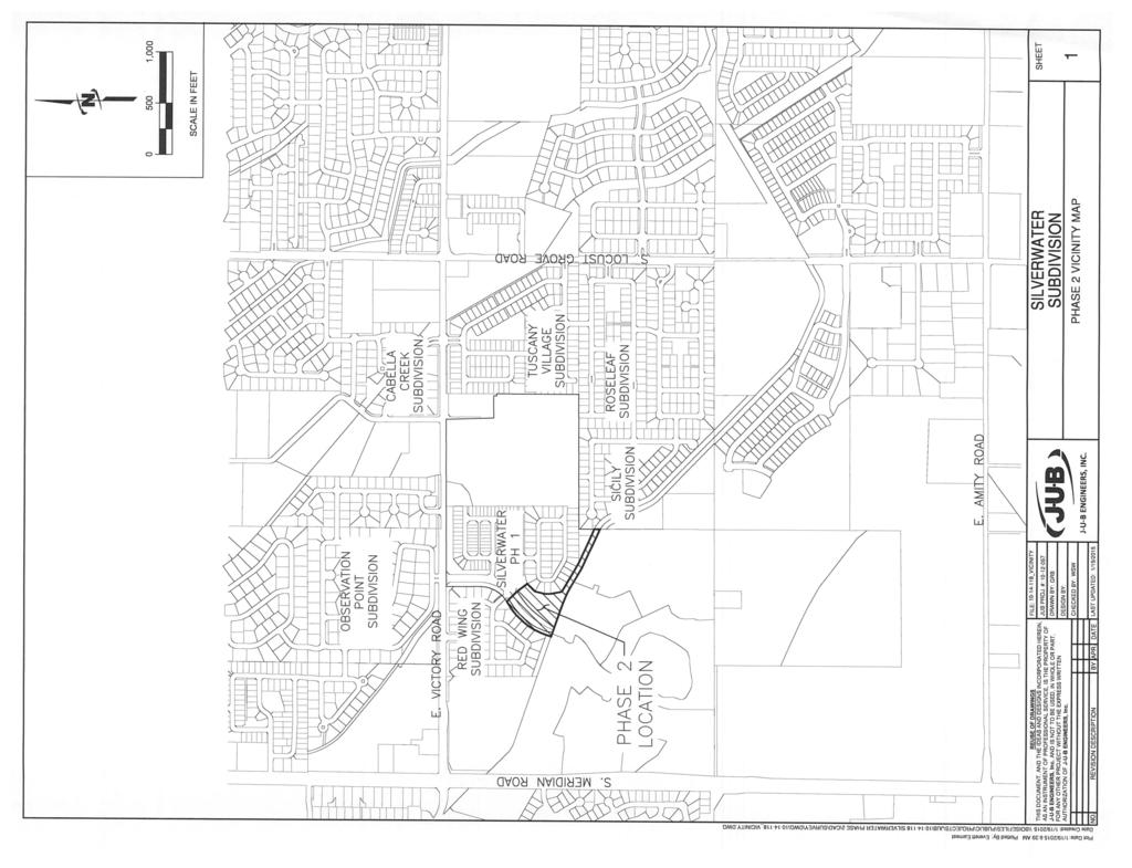
1 Kent Goldthorpe, President Paul Woods, Vice President Rebecca W. Arnold, Commissioner Sara M. Baker, Commissioner Jim D. Hansen, Commissioner February 25, 2016 Development Services Department To: ACHD Commission From: Kaci Bader, Development Review Coordinator Subject: Final Plat: Silverwater Subdivision No. 2 Project Number: SUBP Meeting Date: March 2, 2016 FACTS & FINDINGS: 1. Silverwater Subdivision No. 2 is a 2 common lot residential subdivision on 4.67 acres. This site is located south of E. Victory Road and east of S. Meridian Road. 2. The applicant is Corey Barton Homes, Inc. and the principal for the applicant is Corey D. Barton, President. 3. The preliminary plat was approved on October 24, All conditions of the preliminary plat have been satisfied, except for the completion of the roadway improvements. The applicant has provided a financial surety of $485,300 in the form of a Letter of Credit from Washington Trust Bank in accordance with ACHD Policy Section The applicant is responsible to complete all street improvements and conditions of approval required with the preliminary plat to ACHD standards prior to final acceptance of the street by ACHD and release of the financial surety. RECOMMENDATION: 1. Approve the final plat of Silverwater Subdivision No. 2 and authorize the President to endorse. ATTACHMENTS: 1. Final Plat 2. Vicinity Map 3. Cavanaugh Subdivision preliminary plat, staff report dated October 24, 2007.
2
3
4
5
6

7 Right-of-- Way & Development Department CHD Gon,~, ièol~ fl v7~ ti~ ~ Project/File: Lead Agency: Site address: Cavanaugh Subdivision/MRZ / MCUP /MPP City of Meridian s/e/ c of State Highway 69 & East Victory Road. Commission Hearing: Consent Agenda October 24, 2007 at 6:OOp. m. Applicant: Representative: Kastera Development -Wayne Forrey State HWY 55 Boise, ID Same as Above Staff Contact: Mindy Wallace Phone: mwallacecc~achd. ada.id. us Tech Review: October 19, 2007 Application Information: Acreage: 177 Current Zoning: TN-R, C-N, & R-8 Proposed Zoning: C-N, TN-C, TN-R, R-8 Residential Units: 548 Commercial lots: School: Civic/Social Hall: Open Space: acres A. Findings of Fact Existing Conditions 1. Site Information: There is an existing single-family residence on the site. The balance of the site is utilized for agricultural purposes. 1 Cavanaugh Subdivision
8 2. Description of Adjacent Surrounding Area: Direction Land Use Zonin North South Residential (Observation Point) & Commercial Double D & Nurse Undeveloped (Future Reflection Ridge & ravel it C-G, R-4 & RUT RUT East Residential R-8 West Residential R-6 3. Existing Roadway Improvements and Right-of- Way Adjacent To and Near the Site: Victory Road currently has 2 traffic lanes, and no curb gutter or sidewalk abutting the site. There are three lanes on Victory Road at its intersection with Meridian Road (SH 69), and there is curb, gutter, and detached concrete sidewalk abutting the Victory Greens Nursery site. There is approximately 75-feet of right-ofway existing for Victory Road. Meridian Road (SH 69) currently has 4 traffic lanes, a center turn lane, and no curb, gutter, or sidewalk abutting jurisdiction of the Idaho Transportation Department. the site. Meridian Road is under the 4. Existing Access: There is an existing access on Victory Road to serve the existing home. 5. Site History: ACRD previously reviewed this site as Tanana Valley Subdivision in April Development Impacts Trip Generation: This development is estimated to 12,975 additional vehicle trips per day based on the submitted traffic impact study. 7. Impact Fees: There will be an impact fee that is assessed and due prior to issuance of any building permits. The assessed impact fee will be based on the impact fee ordinance that is in effect at that time. 8. Impacted Roadways: Roadway Frontage Functional Classification Traffic Count Level of Service* Speed Limit Victory Road 3,203' Minor Arterial 6,495 east of Better than 45 MPH Meridian on 4/24/ 07 C" Meridian Road 2,368' Principal Arterial 30,018 north of Better than 55 MPH SH 69) Victory on 6/1/ 07 C" Acceptable level of service for atwo-lane minor arterial roadway is "D" 14,000 ( ADT). Acceptable level of service for afive-lane principal arterial roadway is "E" 37,000 ( ADT). 9. Capital Improvements Plan/Five Year Work Program There are currently no roadways, bridges or intersections in the general vicinity of the project that are currently in the Five Year Work Program or the Districts Capital Improvement Plan (CIP). 2 Cavanaugh Subdivision
9 B. Findings for Consideration Traffic Impact Study The applicant retained Thompson Engineers to prepare a traffic impact study. principal findings, conclusions, and recommendations of that study. Below are the The site will generate 12,975 new trips per day. Of these, 658 trips will occur during hour and 753 trips will occur during the PM Peak hour. the AM Peak The intersection at Rumple Lane/Harris Street and Meridian Road will fail to operate at an acceptable LOS under background PM peak hour traffic conditions. By expanding this intersection to provide left turn lanes at the west bound and eastbound approaches, and installing a traffic signal, this intersection can function at an acceptable LOS through the total PM peak hour traffic conditions in Previous traffic studies have identified this intersection as an intersection for mitigation by year 2011 due to other development. This intersection meets signal warrants 1, 2, and 3 under background PM peak conditions. hour traffic Based on ACRD turn warrant standards, a southbound right turn lane is warranted on Meridian Road at the intersection with Harris Street under background PM peak hour traffic conditions in If a traffic signal is installed at this intersection, turn warrants may change. The intersection at Meridian Road and Victory Road is anticipated to operate near capacity under total PM peak hour traffic conditions. By coordinating signals on Meridian Road, this intersection will operate at LOS D through total PM peak hour traffic conditions in The intersection at Victory Road and Standing Timber Avenue will require a traffic signal to function at an acceptable LOS under total PM peak hour traffic conditions. By expanding the intersection, constructing left turn lanes at every approach, and by installing a traffic signal, this intersection will function at an acceptable LOS through total PM peak hour traffic conditions in This intersection meets signal warrants 1, 2, and 3 under total PM peak hour traffic conditions in The proposed access on Victory Road will require a center left turn lane on the Victory Road to function at an acceptable LOS under total PM peak hour traffic conditions. A northbound right turn lane is warranted on Meridian Road at the intersection with Rumple Lane under total PM peak hour conditions. If a traffic signal is installed at this intersection, turn warrants may change. Curb, gutter, and sidewalk are recommended along Victory and stub roads of the development to accommodate pedestrian and provide connectivity to future developments. Road and the internal streets and school children traffic Staff Comment/Recommendations: Traffic impact study comments are provided by District Traffic Services department. There are several streets within the subdivision that are quite long speeding issues. and could create 3 Cavanaugh Subdivision

10 The consultant has produced a trip capture percentage with no basis or documentation to support it. The consultant will need to provide the appropriate documentation to support the trip capture percentage or revise the TIS to reflect a new percentage of trip capture with supporting documentation. Staff is not in supportive of a traffic signal at the intersection of Victory/Standing Timber at this time. The delay at the intersection is only slightly over LOS F ( 62.1 seconds). LOS F is 50 seconds. The distance from SH-69 intersection is 1900-feet. The location could potentially increase cut through traffic from SH-69. Additionally, the TIS included traffic counts taken while Overland Road was under construction. The District may consider this location for a signal in the future. 2. Meridian Road (SH 69) Meridian Road is under the jurisdiction of the Idaho Transportation Department. The City of Meridian, the applicant and ITD should work together to determine if additional right-ofway or improvements are necessary on Meridian Road ( SH 69). The applicant is proposing an access on Meridian Road at the half-mile in alignment with Harris Street on the west side of the roadway. 3. Victory Road Street Section and Right-of- Way Policy: District policy requires 96-feet of right-ofway roadways (Figure 72-F1 B). This right-ofway allows for the construction of a 5-lane roadway with curb, gutter, 5-foot concrete detached sidewalks and bike lanes. Sidewalk Policy: District policy requires 7-foot wide attached (or 5-foot detached) concrete sidewalk on all collector roadways and arterial roadways ( ). on arterial Staff Comment/Recommendation: The applicant will be required to dedicate a total of 48-feet of right-ofway from the centerline of Victory Road ( or 38-feet from centerline with the sidewalk in an easement) abutting the parcel by means of a warranty deed. The right-ofway purchase and sale agreement and deed must be completed and signed by the applicant prior to scheduling the final plat for signature by the ACHD Commission or prior to issuance of a building permit (or other required permits), whichever occurs first. Allow up to 30 business days to process the right-ofway dedication after receipt of all requested material. The owner will be paid the fair market value of the right-ofway dedicated which is an addition to existing ACRD right-ofway. The applicant will be required to construct a 5-foot detached concrete sidewalk abutting Victory Road located a minimum of 41-feet from the centerline of the roadway. the site on The District recommends that the applicant construct a 5-foot concrete sidewalk across the two outparcels along Victory Road on either side of the proposed school site. This sidewalk should either be constructed within the existing right-ofway or within an easement provided by the property owners. The applicant will be required to construct an eastbound right turn lane and a westbound left turn lane on Victory Road into the site at the intersection with Cavanaugh Way. The applicant should be required to dedicate the additional right-ofway necessary for the turn lanes without compensation. The widening of Victory Road for the auxiliary turn lanes may necessitate the widening of the bridge west of the proposed entrance road. If the bridge widening is necessary to construct the pavement tapers required for the turn lanes the applicant shall be required to design and construct the bridge widening at that time. Additionally, the applicant will be required to construct a left turn lane on Victory Road at the commercial site entrance (S. Enter Way). 4 Cavanaugh Subdivision

11 Due to the required eastbound right-turn lane necessary to serve the development and the need to accommodate drainage, the applicant may need to dedicate additional right-ofway and construct additional street improvements abutting the right-turn lane. If the applicant is unable to fit a minimum 8-foot wide barrow ditch and 3-foot wide gravel shoulder between the edge of pavement and the face of sidewalk due to right-ofway constraints, then the applicant may need to construct vertical curb, gutter, and sidewalk abutting the eastbound right turn lane. Or as an alternative, the applicant may need to move the sidewalk back and dedicate additional right-ofway to allow for the construction of a barrow ditch wide enough to accommodate the drainage. An easement will need to be provided for any segment of the sidewalk located outside of the right-ofway. Coordinate the design of the drainage facility with District Design Review staff. 4. Commercial Entry Roadways Right-of- Way and Street Section Policy: District policy requires 54-feet of right-ofway on industrial/commercial roadways (Figure 72-F1 B). This right-ofway 3-lane roadway with curb, gutter and 5-foot wide concrete sidewalks. allows for the construction of a Roundabout Policy: The roundabout should be designed side of the center island. The applicant will be required to dedicate sufficient right-ofway side of an island. Coordinate the size and design of the roundabout with traffic services staff. with 21-foot street sections on either on either Applicant's Proposal: The applicant is proposing to construct the two commercial entry roads intersecting Victory) as a 40-foot street section with vertical curb, gutter, and 5-foot attached concrete sidewalk within 54-feet of right-ofway. The applicant has proposed to construct roundabout on each of the main commercial roadways. The first roundabout, located on S. Enter Way, is proposed to be located approximately 250-feet south of the north property line. The second roundabout, located on S. Thisa Way, is proposed to be located approximately 490-feet south of the north property line. Staff Comment/Recommendation: The applicant's proposal Policy. However, the intersection of S. Thisa Way with Victory Road is not approved (see finding 11). The applicant will be required to provide a minimum 21-foot street section on either side of the center island. Coordinate the size and design of the roundabout with District Traffic Services staff. for the street section meets District 5. Internal Public Street (Commercial) Commercial Street Section and Right-ofway Policy: District policy requires 54-feet of right-ofway on industrial/commercial roadways (Figure 72-F1 B). This right-ofway allows for the construction of a 3-lane roadway with curb, gutter and 5-foot wide concrete sidewalks. Local Street Section and Right-ofway Policy: District policy states, "developments with any buildable lot that is less that 1-acre in size will typically provide streets having a minimum pavement width of 32-feet with curb, gutter from back-ofcurb to back-ofcurb. Variations of this width may be allowed, depending volumes forecast to be generated by the development. 5-feet in width unless they are separated shall be a minimum of4-feet in width. and sidewalks. The total street width shall be 36-feet on traffic Concrete sidewalks shall be a minimum of from the curb 5-feet or more in which case the sidewalk Diagonal Parking policy: District policy requirements for consideration of diagonal onstreet parking is that the parking is common in the area, existing activities have not feasible possibility of accommodating demand by obtaining adequate parking by off-street parking and a parallel curb parking, a hold harmless agreement is prepared and executed by the proponent of the 5 Cavanaugh Subdivision
12 parking and indicated that the diagonal parking may be required to be removed at the discretion of the Ada County Highway District. Design Guidelines 45 Degree Parking Minimum Street Type Typical Buffer* Stall Dimension Lane Dimension Centerline or Width Lane Line to Curb Face Arterial 12' 15-20' 15' 42' - 47' Collector 11' 10-15' 15' 36-41' Local 10' 5-10' 15' 30-35' Distance based on speed, volume, and other general feet to dimensions if bike lane is needed. characteristics of street. Add additional 5- Applicant's Proposal: The applicant has proposed to construct the internal commercial roadway as follows: S. Entry Way, E. View Water St, and S. Thisa Way, and E. Boardwalk Row between Thisa Way and Cavanaugh Way are proposed to be constructed as a 46-foot street section with vertical curb, gutter, and 5-foot attached sidewalk within 54-feet of right-ofway. E. Summer Walk Way, is proposed curb, gutter, and 5-foot attached sidewalk within 50-feet of right-ofway. to be constructed a 36-foot street section with vertical E. Boardwalk Row from S. Enter Way east approximately 250-feet is proposed to be constructed with foot travel lanes, 19-foot diagonal parking lanes, vertical curb, gutter and concrete sidewalk within 75-feet of right-ofway. E. Boardwalk Row from S. Thisa Way west approximately 180-feet is proposed to be construct with foot travel lanes, 19-foot diagonal parking lanes, vertical curb, gutter, and concrete sidewalk within 75-feet of right-ofway. The remainder of E. Boardwalk Row is proposed to be constructed with 13-foot travel lanes, 20-foot perpendicular parking, vertical curb, gutter, and 5-foot concrete sidewalk within 119- feet of right-ofway. Staff Comment/Recommendation: The applicant's proposals meet District policy with the exception of the proposed street section on E. Boardwalk Row, which includes the perpendicular parking. Staff is not supportive of the perpendicular parking in this location. The applicant can either construct this segment of E. Boardwalk Row with diagonal parking proposed on the remainder of the roadway, or eliminate the on street parking diagonal parking will need to meet the District's 45 Degree parking requirements. 6. Driveways similar to what has been in that location. The Driveway Location Policy: District policy 72-F4 ( 1) and 72-F4 ( 2), requires driveways located on commercial/industrial roadways to offset a controlled and/or uncontrolled intersection a minimum of 50-feet (measured near edge to near edge). 6 Cavanaugh Subdivision

13 Driveway Paving Policy: Graveled driveways abutting public streets create maintenance problems due to gravel being tracked onto the roadway. In accordance with District policy, , the applicant should be required to pave the driveway its full width and at least 30-feet into the site beyond the edge of pavement of the roadway and install pavement tapers with 15-foot radii abutting the existing roadway edge. Driveway Width Policy: District policy restricts commercial driveways with daily traffic volumes over 1,000 vehicles to a maximum width of 36-feet. Most commercial driveways will be constructed as curb-cut type facilities if located on local streets. Curb return type driveways with 15- foot radii will be required for driveways accessing collector and arterial roadways. Applicant's Proposal: The applicant has proposed several driveways located off the proposed internal commercial roadways to serve the proposed commercial development. The first driveways are located off of S. Entry Way and S. Thisa Way and are approximately 100-feet south of Victory Road. Staff Comment/Recommendation: The applicant's proposal meets District Policy. The applicant will be required to pave the driveways there full width and at least 30-feet into the site beyond the edge of pavement of the roadway and install pavement tapers with 15-foot radii abutting the existing roadway edge. Commercial driveways are restricted to a maximum width of 36-feet. 7. Entry Roads (Residential Collector) and 5-foot wide on these Island Policy: District policy and require islands to be constructed a minimum of 4- feet wide with a minimum area of 100-square feet and designed to safely channel traffic. The roadway on either side of the traffic island should maintain a minimum of a 21-foot street section. The design should be reviewed and approved by ACHD's Development staff. Street Section & Right-of- Way Policy: District policy 72-F1A, and , requires that residential collectors be constructed as 36-foot street sections with curb, gutter concrete sidewalks with no front-on housing. The access restrictions for these street segments should be stated on the final plat. Unless otherwise noted, parking should be prohibited street segments. Coordinate the signage Program with District staff. Applicant Proposal: The applicant is proposing to construct the entrance road, Cavanaugh Way intersecting Victory) as a residential collector from its intersection with Victory through the site to the south property line crossing the Ridenbaugh Canal. The street is proposed as a boulevard style with a 27-foot wide island and 21-foot street sections on each side of the island within 75-feet of right-ofway. The applicant has proposed 5-foot wide detached concrete sidewalks along the residential collector located outside of the right-ofway. The applicant is proposing the entrance road, Harris Street (intersecting Meridian Road), as residential collector. The applicant is proposing the entrance road, Harris Street (intersecting Meridian Road), as residential collector. This street is proposed to be a 33-foot street section with no front-on housing. Staff Comment/Recommendation: The applicant's proposal for Cavanaugh Way meets District policy. The applicant will be required to re-design the intersection of Cavanaugh Way & Victory and to allow for simultaneous left and right turns eastbound and westbound) on Cavanaugh Way. the center island to not exceed 12-feet in width at Harris Street will be required to be constructed as a standard residential collector with a 36-foot street section from its intersection with Meridian Road to its intersection with the stub street being extended from Reflection Ridge (Cavanaugh Way). The 36-foot street section would include 7 Cavanaugh Subdivision
14 vertical curb, gutter, and sidewalk on the north side of the roadway and a gravel shoulder and barrow ditch on the south. The 36-foot street section is needed at the intersection of Harris Street and Meridian Road to allow simultaneous left and right turns out of the development. (See Finding 13 and #14 below). 8. Internal Public Streets (Residential) Street Sections and Right-of- Way Policy: District policy 72-F1A, allows local residential public if the amount of roads with a 33-foot street section with parking on both sides of the roadway, vehicle trips per day on the street does not exceed 1,000 and the appropriate fire department reviews and approves the street section. The proposed density of development that will utilize the internal local residential streets is anticipated to generate less than 1,000 vehicle trips per day. Applicant Proposal: The applicant is proposing to construct the internal local streets as 33-foot street sections with rolled curb, gutter, 4-foot detached concrete sidewalks and 5-foot planter strips within 50-feet of right-ofway. Staff Comment/Recommendation: The applicant's proposal meets District policy with the exception of the 4-foot sidewalks. The applicant will be required sidewalks. The applicant will be required to receive written approval from the Meridian Fire Department for the reduced street section. 9. Alleys to construct 5-foot detached Alley Policy: District policy requires the minimum right-ofway width for new alleys to be 16-feet if: the alley is abutted by residential uses and zoning on both sides; and building setbacks required by the land use agency having jurisdiction provide sufficient space for the safe backing of vehicles into the alley; and 20-feet in all other situations. Dedication of clear title to the right-ofway and the improvement of the right-ofway, and acceptance of the improvement by the District as meeting its construction standards, are required for all alleys contained in a proposed development. Access Policy: Access is allowed to and from a fully improved alley (District policy ). Parking shall be designed so the minimum clear distance from the back of the parking stall to the opposite side of the alley is 22-feet for perpendicular parking. An access to an alley shall be located a minimum of 25-feet from the nearest public street. Intersection Policy: District Policy required at all alley intersections. 3 states a minimum of back-ofcurb radius of 15-feet is Design Policy: District policy states that alleys shall connect to a public street at each end and shall not terminate in dead-ends. Alleys with curves are not allowed without specific District approval taken on good cause shown. Curves shall have a minimum inside radius of 26-feet. Applicant Proposal.: The applicant is proposing to construct two 20-foot alleys Avenue and S. Kamivar Avenue in phase one of the development and two 16-foot alleys between blocks 24 and 25 and blocks 26 and 27 in the commercial section of the development. alleys are straight and intersect a public street at both ends. between S. Koluna All of the Staff Comment/Recommendation: The applicant's proposal meets District policy and should be approved with this application. 10. Entry Road ( Local Residential in alignment with Mesa Way) Policy: District policy states "if a proposed development abuts an unpaved street or streets the developer shall construct one-half of the full street improvements, including curb, gutter 8 Cavanaugh Subdivision

15 and concrete sidewalk plus additional pavement widening beyond the centerline established for the street to provide a minimum 24-feet wide paved surface. A 3-foot wide gravel shoulder and a drainage swale sized to accommodate the roadway storm runoff shall be constructed on the unimproved side. This street section shall be constructed within a minimum 40-foot right-ofway. Staff Comment/Recommendation: During a conversation with staff the applicant had indicated that the school site proposed within the development would become a high school with no bus service, not an elementary school as staff originally thought. With no bus service to the school it is anticipated that most of the children attending would either drive themselves or have a parent dropoff and pick-up. Staff is concerned that the additional traffic generate by the high school will overload the local residential street proposed to provide access to the school site. To preserve the function and safety of the local residential roadway additional public street access will be needed. There for the applicant will be required to construct a public street in alignment with Mesa Way on the north side of Victory Road. Mesa Way south of Victory Road will be required to be constructed in alignment with Mesa Way (centerline to centerline) on the north side of Victory Road. This roadway will be required to be constructed as one-half of a 36-foot street section with vertical curb, gutter, and 5-foot concrete sidewalk on the west side, a minimum of 24-feet of pavement, and a 3- footgravel shoulder and adequately sized barrow ditch on the east side of the roadway. This road will be required to be within a minimum 40-foot of right-ofway. If the applicant cannot achieve an alignment with Mesa Way on the north side of the roadway, the applicant should re-design this portion of the site to provide another local street access for the school site. The street should meet District intersection offset policies. In addition, the half-street is proposed to located adjacent to the Grange property, and District staff does not believe that the parcel would need this type of local street for re-development and access purposes. The Grange property already has a stub street from Tuscany Village and one stub street from this site. 11. Roadway Offsets Access Policy: District policy states that direct access to arterials and collectors is normally restricted. The developer shall try to use combined access points. If the developer can show that the use of a combined access point to a collector or arterial street is impractical, the District may consider direct access points. Access points for proposed developments at intersections should be located as far from the intersection as practical, and in no case closer than as illustrated on Figure 72-F4, unless a waiver for the access point has been approved by the District Commission. Access Policy: District policy states that direct access to arterials and collectors is normally restricted. The developer shall try to use combined access points. If the developer can show that the use of a combined access point to a collector or arterial street is impractical, the District may consider direct access points. Access points for proposed developments at intersections should be located as far from the intersection as practical, and in no case closer than as illustrated on Figure 72-F4, unless a waiver for the access point has been approved by the District Commission. Offset Policy: District policy , requires local roadways to align 300-feet from an arterial roadway (measured centerline to centerline). or offset a minimum of District policy , requires local roadways to align or offset a minimum of 150-feet from a residential collector roadway (measured centerline to centerline). District policy , requires local roadways to align or offset a minimum of 125-feet from another local roadway (measured centerline to centerline). 9 Cavanaugh Subdivision

16 Applicant Proposal: The applicant is proposing to construct the main entrance roadway, Cavanaugh Way intersecting Victory Road, in alignment with Standing Timber Way (Observation Point Subdivision) on the north side of Victory Road. In addition the applicant has proposed two commercial roadways to intersect Victory Road. The first, S. Enter Way is proposed to be located approximately 670-feet ( measured property line to centerline) east of Meridian Road. The second roadway S. Thisa Way is proposed to be located approximately1,280- feet (measured property line to centerline) east of Meridian Road. Staff Comment/Recommendation: The applicant's proposals meet for Cavanaugh Way and S. Enter Way meet District Policy, as they both align with previously approved roadways side of Victory Road. With the recent approval of Emerson Park Subdivision, the location of on the north Emerson Street was approved on the north side of Victory Road. Based on the submitted preliminary plats S. Enter Way and Emerson Street should align. The applicant will be required to align S. Enter Way centerline to centerline with Emerson Street on the north side of Victory Road. Coordinate the ultimate location of the roadway with Tim Mussell or Toothman-Orton Engineering. The applicant's proposal for S. Thisa Way will not be approved as proposed. Consistent with District access management policy, access to arterial and collector roadways is normally restricted. The commercial site can adequately be served the residential collector roadway (Cavanaugh Way) and the approved commercial roadway (S. Enter Way). 12. Stub Streets Policy: District policy states that the street design in a proposed development shall cause no undue hardship to adjoining property. An adequate and convenient access to adjoining property for use in future development may be required. If a street ends at the development boundary, it shall meet the requirements of sub section 7205, "non-continuous streets." District policy states that stub streets will be required to provide intra-neighborhood circulation or to provide access to adjoining properties. Stub streets will conform with the requirements described in Section , and , except a temporary cul-desac will not be required if the stub street has a length no greater than 150-feet. A sign shall be installed at the terminus of the stub street stating that, "THIS ROAD WILL BE EXTENDED IN THE FUTURE". Applicant Proposal: The applicant is proposing to extend or connect to several surrounding proposed or existing stub streets. They are as follows: Extending a stub street from the east and from the south from within Tuscany Village Subdivision. Constructing a new stub street to the south to an undeveloped parcel. Extending a stub street from the east from within Reflection Ridge Subdivision. Staff Comment/Recommendation: The applicant's proposals meet District policy. In addition the applicant will be required to extend a stub street from the south within Reflection Ridge Subdivision. It appears that E. Organic Avenue would align with the stub street from the south if it were to be extended south from its intersection with E. Frank Lloyd Street. 13. Signal at Harris Street & Meridian Road ( SH 69) The submitted TIS states that a signal is warranted at the site access (Harris Street) intersection with Meridian Road (SH69). Harris Street is located at the half-mile, and this location meets the requirements of the City of Meridian's Unified Development Code for an access location. The applicant should be required to provide a road trust deposit with the District for one-half of the cost for the design and construction of the signal. When the property develops, they can utilize the road trust deposit funds to construct the signal at that time OR at the time when ITD approves a signal in that location. Depending on the signal design, Harris Street may need to be wider at is intersection with Meridian Road. on the west side of Meridian Road 10 Cavanaugh Subdivision
17 14. Rumpel Lane There is an existing private lane, Rumpel Lane, located at this site's south property line that intersects Meridian Road generally in alignment with Harris Street on the west side of the roadway. The applicant has acquired Rumpel Lane and incorporated the street as part of the new residential collector (Harris Street). The intent is to close Rumpel Lane and have only one street intersecting Meridian Road at the half-mile. 15. Bridge for Ridenbaugh Canal Crossing The District will require that the applicant submit the bridge plans for the crossing of the Ridenbaugh Canal ( Cavanaugh Way) for review and approval prior to the pre-construction meeting and plat approval. 16. Traffic Calming District policy states that the design of local street systems should discourage excessive speeds by using curvilinear alignment and/or breaks in the street system. Staff Comment/Recommendation: There is one roadway E. Frank Lloyd Street that is approximately 2,000- feet in length or longer, and the applicant will be required to provide traffic calming along this local street ( i.e. chokers, bulb-outs, traffic circles, etc.). The applicant should coordinate the location and design of the traffic calming devices with District Traffic Services staff. 17. Tree Planter Policy The applicant should also comply with the District's Tree Planter Width Interim Policy which prohibits all trees in planters less than 6-feet in width. In addition to prohibiting trees in planters less than 6-feet in width, the policy requires a minimum planter width of 6-feet for class II tress with the installation of root barriers on both sides of the planter strip or a minimum planter width of 8-feet without the installation of a root barrier. The policy also requires Class I provide a minimum planter width of 10-feet. and Class III trees to 8. Other Access Victory Road is classified as a minor arterial roadway. Meridian Road is classified as a principal arterial roadway. Other than the access specifically approved with this application, direct lot access to Victory and Meridian Roads is prohibited and should be noted on the final plat. C. Site Specific Conditions of Approval 1. The City of Meridian, the applicant and ITD should work together to determine if additional right-ofway or improvements are necessary on Meridian Road ( SH 69). 2. Dedicate a total of 48-feet (or 38-feet with the sidewalk in an easement) of right-ofway from the centerline of Victory Road abutting the parcel by means of a warranty deed. The right-ofway purchase and sale agreement and deed must be completed and signed by the applicant prior to scheduling the final plat for signature by the ACHD Commission or prior to issuance of a building permit (or other required permits), whichever occurs first. Allow up to 30 business days to process the right-ofway dedication after receipt of all requested material. The owner will be paid the fair market value of the right-ofway dedicated which is an addition to existing ACHD right-ofway. 11 Cavanaugh Subdivision

18 3. Construct a 5-foot detached concrete sidewalk abutting the site on Victory Road located a minimum of 41-feet from the centerline of the roadway. If any portion of the sidewalk is located outside the public right-ofway, the applicant shall provide the District with an easement. 4. The District recommends that the applicant construct a 5-foot concrete sidewalk across the two outparcels along Victory Road on either side of the proposed school site. This sidewalk should either be constructed within the existing right-ofway or within an easement provided by the property owners. 5. Construct an eastbound right turn lane and a westbound left turn lane on Victory Road into the site at the intersection with Cavanaugh Way. Dedicate the additional right-ofway necessary for the turn lanes without compensation. The widening of Victory Road for the auxiliary turn lanes may necessitate the widening of the bridge west of the proposed entrance road. If the bridge widening is necessary to construct the pavement tapers required for the turn lanes the applicant shall be required to design and construct the bridge widening at that time. 6. Construct on one commercial entry road to intersect Victory Road, S. Enter Way, located approximately 670-feet east of Meridian Road. The roadway shall be constructed as a 40-foot street section with vertical curb, gutter, and sidewalk within 54-feet of right-ofway. S. Enter Way is required to align centerline to centerline with Emerson Street on the north side of Victory Road. 7. Construct the internal commercial roadways identified below, as proposed. S. Entry Way, E. View Water St, and S. Thisa Way, and E. Boardwalk Row between Thisa Way and Cavanaugh Way are proposed to be constructed as a 46-foot street section with vertical curb, gutter, and 5-foot attached sidewalk within 54-feet of right-ofway. E. Summer Walk Way, is proposed curb, gutter, and 5-foot attached sidewalk within 50-feet of right-ofway. to be constructed a 36-foot street section with vertical E. Boardwalk Row from S. Enter Way east approximately 250-feet is proposed to be constructed with foot travel lanes, 19-foot diagonal parking lanes, vertical curb, gutter and concrete sidewalk within 75-feet of right-ofway. E. Boardwalk Row from S. Thisa Way west approximately 180-feet is proposed to be construct with foot travel lanes, 19-foot diagonal parking lanes, vertical curb, gutter, and concrete sidewalk within 75-feet of right-ofway. Construct the remainder of E. Boardwalk Row with diagonal parking or with no on street parking in that location. 8. Construct the commercial driveway located of off the commercial entry roads ( S. Enter Way and S. Thisa Way) no closer than 50-feet from Victory Road. Pave the driveways their full width and at least 30-feet into the site beyond the edge of pavement of the roadway and install pavement tapers with 15-foot radii abutting the existing roadway edge. Commercial driveways are restricted to a width of 36-feet. 9. Construct the entrance road, Cavanaugh Way (intersecting Victory) as a residential collector with vertical curb, gutter, and 5-foot concrete sidewalk, from its intersection with Victory through to the south property line crossing the Ridenbaugh Canal. The street should be constructed as a the site boulevard style with a 27-foot wide islands and 21-foot street sections on each side of the island. The center islands shall be owned and maintained by the homeowner's association. If any portion of the sidewalk is located outside of the public right-ofway, the applicant will be required to provide an easement. The applicant shall re-design the center island (to be no wider than 12-feet) at the 12 Cavanaugh Subdivision
19 intersection of Cavanaugh Way & Victory to allow for simultaneous left and right turns (eastbound and westbound) on Cavanaugh Way. 10. Construct Harris Street, the entrance street intersecting Meridian Road at the half-mile, as a standard residential collector with a 36-foot street section (vertical curb, gutter, and 5-foot concrete sidewalk on the north side of the road and a gravel shoulder and barrow ditch on the south.) from its intersection with Meridian Road to its intersection with the stub street being extended from Reflection Ridge 11. Provide a road trust deposit with the District for one-half of the cost for the design and construction of the signal for the intersection of Harris Street and Meridian Road ( SH 69). When the property on the west side of Meridian Road develops, the road trust deposit funds can be utilized to construct the signal at that time OR at the time when ITD approves a signal in that location. Design Harris Street to accommodate a future signal at the intersection with Meridian Road. 12. District staff recommends that the private lane, Rumpel Lane, be closed and/or incorporated into the new public street, Harris Street, and that all access be taken to the new public street. The City of Meridian and ITD should coordinate on the future closure of this roadway to ensure that only one street intersects Meridian Road at the half-mile. 13. Construct the internal local streets as 33-foot street sections with rolled curb, gutter, and 5-foot detached concrete sidewalks within 50-feet of right-ofway. Receive written approval from the Meridian Fire Department for the reduced street section OR construct the streets as standard 36- foot street sections. 14. Construct two 20-foot wide alleys in Block 21 & 22, and two 16-foot alleys in Block 26 & 27 and Blocks 24 & 25, as proposed. The alleys shall comply with the following policies: Minimum right-ofway width is to be 16-feet. Access is allowed to and from a fully improved alley (District policy ). Parking shall be designed so the minimum clear distance from the back of the parking stall to the opposite side of the alley is 22-feet for perpendicular parking. An access to an alley shall be located a minimum of 25-feet from the nearest public street. A minimum of back-ofcurb radius of 15-feet is required at all alley intersections. 15. Extend a stub street from the east and from the south from within Tuscany Village Subdivision. 16. Extend a stub street from the east and from the south from within Reflection Ridge Subdivision. 17. Construct a new stub street to the south and one to the east to the undeveloped parcel. Install a sign at the terminus of the roadways stating, THIS " ROAD WILL BE EXTENDED IN THE FUTURE." If the stub streets are greater than 150-feet in length, provide a temporary turnaround at the terminus of the roadways. 18. Construct a public street in alignment with Mesa Way on the north side of Victory Road. Mesa Way south of Victory Road will be required to be constructed in alignment with Mesa Way (centerline to centerline) on the north side of Victory Road. This roadway will be required to be constructed as one-half of a 36-foot street section with vertical curb, gutter, and 5-foot concrete sidewalk on the west side, a minimum of 24-feet of pavement, and a 3-foot gravel shoulder and adequately sized barrow ditch on the east side of the roadway. This road will be required feet of right-ofway. If an alignment with Mesa Way cannot be achieved, the applicant should redesign this portion of the site to provide another local street access for the school site. to be within a minimum Cavanaugh Subdivision
20 19. Submit the bridge plans for the crossing of the Ridenbaugh Canal ( Cavanaugh Way) for review and approval prior to the pre-construction meeting and plat approval. 20. Other than the access specifically approved with this application, direct lot access to Victory and Meridian Road is prohibited and shall be noted on the final plat. 21. Comply with all Standard Conditions of Approval. D. Standard Conditions of Approval 2. Private sewer or water systems are prohibited from being located within any ACRD roadway or Any existing irrigation facilities shall be relocated outside of the right-ofway. right-ofway. 3. All utility relocation costs associated with improving street frontages abutting by the developer. the site shall be borne 4. Replace any existing damaged curb, gutter and sidewalk and any that may be damaged during the construction of the proposed development. Contact Construction Services at (with file number) for details. 5. Comply with the District's Tree Planter Width Interim Policy. 6. Utility street cuts in pavement less than five years old are not allowed unless approved in writing by the District. Contact the District's Utility Coordinator at ( with file numbers) for details. 7. All design and construction shall be in accordance with the Ada County Highway District Policy Manual, ISPWC Standards and approved supplements, Construction Services procedures and all applicable ACRD Ordinances unless specifically waived herein. An engineer registered in the State of Idaho shall prepare and certify all improvement plans. 8. The applicant shall submit revised plans for staff approval, prior to issuance of building permit (or other required permits), which incorporates any required design changes. 9. Construction, use and property development shall be in conformance with all applicable requirements of the Ada County Highway District prior to District approval for occupancy. 10. Payment of applicable road impact fees are required prior to building construction in accordance with Ordinance #200, also known as Ada County Highway District Road Impact Fee Ordinance. 11. It is the responsibility of the applicant to verify all existing utilities within the right-ofway. The applicant at no cost to ACRD shall repair existing utilities damaged by the applicant. The applicant shall be required to call DIGLINE ( ) at least two full business days prior to breaking ground within ACRD right-ofway. The applicant shall contact ACHD Traffic Operations in the event any ACRD conduits ( spare or filled) are compromised during any phase of construction. 12. No change in the terms and conditions of this approval shall be valid unless they are in writing and signed by the applicant or the applicant's authorized representative and an authorized representative of the Ada County Highway District. The burden shall be upon the applicant to obtain written confirmation of any change from the Ada County Highway District. 14 Cavanaugh Subdivision

21 13. Any change by the applicant in the planned use of the property which is the subject of this application, shall require the applicant to comply with all rules, regulations, ordinances, plans, or other regulatory and legal restrictions in force at the time the applicant or its successors in interest advises the Highway District of its intent to change the planned use of the subject property unless a waiver/variance of said requirements or other legal relief is granted pursuant to the law in effect at the time the change in use is sought. E. Conclusions of Lavv 1. The proposed site plan is approved, if all of the Site Specific and Standard Conditions of Approval are satisfied. 2. ACHD requirements are intended to assure that the proposed use/development will not place an undue burden on the existing vehicular transportation system within the vicinity impacted by the proposed development. Attachments 1. Vicinity Map 2. Site Plan 3. Commercial Street Layout 4. Request for Reconsideration Guidelines 5. Utility Coordination 6. Development Process Checklist 15 Cavanaugh Subdivision
22 I m A _ n v c 97-. a G D~" G~x, p D OJ O., ( n.z C '" ~ ~+ s Z ~ D ~, D O ~ o Y.~t d C z D U~ 1 m, A D O o~; m ~ z gj=~ m n ~~ P~~ m o ~ z r r- o~ m P Wiz;; U ~, z v.l o"~.; m ~ s'~= ~ s?~, r Z m z ~ F=~ g, c~, cr' S m C c vai D f G S3? C ail `~ X ~ p a h ~. m 41 a e 4~ ~ ~ a i. F cf ee CAVANAUGH SUBDIVISION o ki g MERIDIAN, ADA COUNTY, IDAHO m ia_ IN ~ r COVER BREET i w J-U B ENGINEERS, Inc. ~ Beachwood Avenue sutle zoi Q. Boise,ldaho j mane'. msa~s. rsso ' Fei~08 ~BdM 1 jua 1 a 16 Cavanaugh Subdivision
23 c ~ 40-foot street section in 54-feet of right-ofway = 36-foot street section in 50-feet of right-ofway = 61-foot street section (diagonal parking) in 75-feet of right-ofway = ~ 16-foot alley = m o J n a c A - - z D y. 9 Z m a i ~ ~ ~: ~ O ~ y ~. c ~ ~ Ti ~ Z i D o _ = U1 a ;,, z = v ~ 1 ~ w V ~ O ~ D 1 ~ O ~ G N n O z T rv' 17 Cavanaugh Subdivision
24 Development Process Checklist Submit a development application to a City or to the County The City or the County will transmit the development application to ACHD The ACHD Planning Review Division will receive the development application to review The Planning Review Division will do one of the following: Send a "No Review" letter to the applicant stating that there are no site specific requirements at this time Send a "Comply With" letter to the applicant stating that if the development is within a platted subdivision or part of a previous development application and that the site specific requirements from the previous development also apply to this development application. Write a Staff Level report analyzing the impacts of the development on the transportation system and evaluating the proposal for its conformance to District Policy. Write a Commission Level report analyzing the impacts of the development on the transportation system and evaluating the proposal for its conformance to District Policy. The Planning Review Division will hold a Technical Review meeting for all Staff and Commission Level reports. For ALL development applications, including those receiving a "No Review" or " Comply With" letter: The applicant should submit two ( 2) sets of engineered plans directly to ACHD for review by the Development Review Division for plan review and assessment of impact fees. ( Note: if there are no site improvements required by ACRD, then architectural plans may be submitted for purposes of impact fee calculation.) The applicant is required to get a permit from Construction Services (ACHD) for ANY work in the right-of-- way, including, but not limited to, driveway approaches, street improvements and utility cuts. Pay Impact Fees prior to issuance of building permit. Impact fees cannot be paid prior to plan review approval. DID YOU REMEMBER: Construction (Zone) Driveway or Property Approach(s) Submit a "Driveway Approach Request" form to Ada County Highway District (ACHD) Construction (for approval by Development Services & Traffic Services). There is a one week turnaround for this approval. Working in the ACHD Right-of- Way Four business days prior to starting work have a bonded contractor submit a " Temporary Highway Use Permit Application" to ACHD Construction -Permits along with: a) Traffic Control Plan b) An Erosion & Sediment Control Narrative & Plat, done by a Certified Plan Designer, if trench is >50' or you are placing > 600 sf of concrete or asphalt. Construction (Subdivisions) Sediment 8~ Erosion Submittal At least one week prior to setting up a Pre-Con an Erosion & Sediment Control Narrative & Plat, done by a Certified Plan Designer, must be turned into ACHD Construction -Subdivision to be reviewed and approved by the ACHD Drainage Division. Idaho Power Company Vic Steelman at Idaho Power must have his IPCO approved set of subdivision utility plans prior to Pre-Con being scheduled. Final Approval from Development Services ACHD Construction -Subdivision must have received approval from Development Services prior to scheduling apre-con. 18 Cavanaugh Subdivision
2. Caven Ridge Estates Subdivision No. 1 adds 0.54 centerline miles to the ACHD roadway system.
 Kent Goldthorpe, President Paul Woods, Vice President Rebecca W. Arnold, Commissioner Sara M. Baker, Commissioner Jim D. Hansen, Commissioner October 12, 2016 Development Services Department To: From:
Development Services Department
 Kent Goldthorpe, President Paul Woods, Vice President Rebecca W. Arnold, Commissioner Sara M. Baker, Commissioner Jim D. Hansen, Commissioner July 28, 2016 Development Services Department To: From: ACHD
BPP / SUB
 Development Services Department Project/File: Lead Agency: Site address: Millwell Place Subdivision/ BPP15-0031/ SUB15-0064 This is a preliminary plat application to allow for the development of 68 building
ACHD Board of Commissioners Stacey Yarrington, Planner III Tandem Ridge/ EPP / PP-07-16/ RZ-12-16/ CPA-01-16/ A-07-16
 Development Services Department DATE: December 14, 2016 TO: FROM: SUBJECT: ACHD Board of Commissioners Stacey Yarrington, Planner III Tandem Ridge/ EPP16-0012/ PP-07-16/ Executive Summary: This is an annexation,
BOI / DRH S. 13 th Street Mixed use office/retail development with residential dormitory
 Jim D. Hansen, President Sara M. Baker, Vice President Rebecca W. Arnold, Commissioner Kent Goldthorpe, Commissioner Paul Woods, Commissioner October 21, 2015 To: Rick Nesser ISS River Partners, LLC 8312
 Development Services Department Project/File: Lead Agency: Site address: Fall Creek Subdivision (MPP-12-016) This is a preliminary plat application to subdivision approximately 110 acres into 296 residential
Development Services Department
 Kent Goldthorpe, President Paul Woods, Vice President Rebecca W. Arnold, Commissioner Sara M. Baker, Commissioner Jim D. Hansen, Commissioner July 21, 2016 Development Services Department To: From: ACHD
Committed to Service. Development Services. February 21, ACHD Commission. Mindy Wallace, AICP
 Committed to Service Sara M. Baker, President Rebecca W. Arnold, Vice President Jim D. Hansen, Commissioner Kent Goldthorpe, Commissioner Paul Woods, Commissioner February 21, 2018 Development Services
 Development Services Department Project/File: Lead Agency: Site address: Applicant: Memory Ranch / KPP15-0003 / 15-02-AN / 15-01-S The applicant is requesting annexation of approximately 10 acres, rezoning
 Development Services Department Project/File: Lead Agency: Site address: Aralar Park/SUB13-00048 This is a preliminary plat application to construct 55 buildable lots and 6 common lots on 12.67 acres.
BPP / SUB /CAR /PUD
 Development Services Department Project/File: Lead Agency: Site address: Roe Street Townhomes/ BPP16-0023/ SUB16-00046/CAR16-00023/PUD16-00022 This is a rezone, preliminary plat, and planned unit development
Committed to Service
 Development Services Department Committed to Service January 19, 2016 TO: FROM: SUBJECT: ACHD Board of Commissioners Mindy Wallace, AICP Planner III Kirsten Subdivision/BPP15-0023 Executive Summary: The
Committed to Service
 Committed to Service Kent Goldthorpe, President Paul Woods, Vice President Rebecca W. Arnold, Commissioner Sara M. Baker, Commissioner Jim D. Hansen, Commissioner May 24, 2017 Development Services TO:
Subdivision Staff Report
 Subdivision Staff Report Subdivision Name Plano Road Subdivision File Number SUB07-00065 Approval Preliminary Plat Lead Agency Boise City Annexation Date Pending (CAR07-00042/DA) Comp. Plan Does Not Comply
Committed to Service
 Development Services Department Committed to Service June 30, 2014 TO: FROM: SUBJECT: ACHD Board of Commissioners Christy Little Planning Review Supervisor Victory Middle School/MCUP-14-003 DATE: July
Committed to Service
 Committed to Service Paul Woods, President Rebecca W. Arnold, Vice President Sara M. Baker, Commissioner Jim D. Hansen, Commissioner Kent Goldthorpe, Commissioner September 19, 2017 Development Services
Committed to Service
 Committed to Service Sara M. Baker, President Rebecca W. Arnold, Vice President Jim D. Hansen, Commissioner Kent Goldthorpe, Commissioner Paul Woods, Commissioner February 21, 2018 Development Services
This Chapter sets forth the minimum design, technical criteria and specifications to be used in the preparation of all roadway plans.
 4.1 GENERAL This Chapter sets forth the minimum design, technical criteria and specifications to be used in the preparation of all roadway plans. These Roadway Standards are for new construction and modification
Committed to Service
 Development Services Department Committed to Service TO: FROM: Ada County Highway District Commissioners Mindy Wallace, AICP Planner III COMISSION HEARING: January 27, 2016 SUBJECT: Syringa Valley Specific
Roadway Classification Design Standards and Policies. Pueblo, Colorado November, 2004
 Roadway Classification Design Standards and Policies Pueblo, Colorado November, 2004 Table of Contents Page Chapter 1. General Provisions 1.1 Jurisdiction 3 1.2 Purpose and Intent 3 1.3 Modification 3
SECTION 3 STREET DESIGN
 3.01 GENERAL SECTION 3 STREET DESIGN For purposes of geometric and structural design, streets shall be classified according to the following table. The City Engineer will determine the class of all proposed
Street Paving and Sidewalk Policy
 City Commission Policy 600 Street Paving and Sidewalk Policy DEPARTMENT: Public Works DATE ADOPTED: June 7, 1995 DATE OF LAST REVISION: December 10, 2014 Policy No. 600.01 AUTHORITY: PASS City of Tallahassee-Leon
Town of Siler City - Unified Development Ordinance ARTICLE XIV - Streets and Sidewalks
 ARTICLE XIV - Streets and Sidewalks 193 Street Classification (a) In all new subdivisions, streets that are dedicated to public use shall be classified as provided in 193(b) (1) The classification shall
T A B L E OF C O N T E N T S
 T A B L E OF C O N T E N T S PART III SUBDIVISION REGULATIONS OF THE DEPARTMENT OF PUBLIC WORKS, C & C D PAGE PAGE Responsibility for Development of Streets......... 29 Right-of-Way Widths...... 37 Purpose...........
Development Services Department
 Development Services Department Project/File: Lead Agency: Site address: Harris Ranch Specific Area Plan Text Amendments/ZOA14-00001 The applicant is requesting approval of a text amendment application
5.0 Roadway System Plan
 Southwest Boise Transportation Study Page 16 5.0 Roadway System Plan The Roadway System Plan outlines roadway improvements in the Initial Study Area. It forecasts future deficiencies on the arterial system,
Access requests to County streets and roadways are processed through one of the following methods:
 13.1 GENERAL APPLICATION PROCESS Access requests to County streets and roadways are processed through one of the following methods: A. Planned Developments may set general locations for access points.
December 2, ACHD Board of Commissioners. Lauren Watsek Planner I. PUD (Deep Green Condominiums) Executive Summary:
 Executive Summary:") Development Services Department December 2, 2013 TO: FROM: SUBJECT: ACHD Board of Commissioners Lauren Watsek Planner I PUD13-00013 (Deep Green Condominiums) Executive Summary: The applicant is requesting
Development Services Department December 2, 2013 TO: FROM: SUBJECT: ACHD Board of Commissioners Lauren Watsek Planner I PUD13-00013 (Deep Green Condominiums) Executive Summary: The applicant is requesting
DRAFT - CITY OF MEDFORD TRANSPORTATION SYSTEM PLAN Roadway Cross-Sections
 Roadway Cross-Sections Medford s roadway cross-section standards apply to new and reconstructed roads. The crosssections take into consideration roadway function and operational characteristics, including
APPENDIX G: INTERSECTION NEEDS AT OKEECHOBEE BOULEVARD
 APPENDIX G: INTERSECTION NEEDS AT OKEECHOBEE BOULEVARD INTERSECTION NEEDS AT SR 7 and OKEECHOBEE BOULEVARD SR 7 Extension Project Development and Environment (PD&E) Study From Okeechobee Boulevard (SR
Committed to Service
 Committed to Service Paul Woods, President Rebecca W. Arnold, Vice President Sara M. Baker, Commissioner Jim D. Hansen, Commissioner Kent Goldthorpe, Commissioner January 16, 2018 Development Services
State Street and Pierce Park Lane Intersection Concept Report
 State Street and Pierce Park Lane Intersection Prepared for September 2017 Prepared by CITATION Parametrix. 2017. State Street & Pierce Park Lane Intersection. Prepared by Parametrix, Boise, ID. September
Houma-Thibodaux Metropolitan Planning Organization STP<200K Funding Application APPLICATION
 APPLICATION HOUMA-THIBODAUX METROPOLITAN PLANNING ORGANIZATION (HTMPO) FOR SURFACE TRANSPORTATION PROGRAM (STP
GWINNETT COUNTY DEPARTMENT OF TRANSPORTATION
 GWINNETT COUNTY DEPARTMENT OF TRANSPORTATION 1 of 7 June 20, 2007 GENERAL: The following guidelines shall be used in the determination of the requirement for left turn lanes for development projects and
TOWN OF CHAPEL HILL POLICY AND PROCEDURES FOR TRAFFIC CALMING MEASURES
 TOWN OF CHAPEL HILL POLICY AND PROCEDURES FOR TRAFFIC CALMING MEASURES (Adopted by the Town Council on June 30, 2004) (Revised December 6, 2010) (Revised February 8, 2016) POLICY AND PROCEDURES FOR TRAFFIC
Clackamas County Comprehensive Plan
 ROADWAYS The County s road system permits the movement of goods and people between communities and regions, using any of a variety of modes of travel. Roads provide access to virtually all property. They
MAJOR THOROUGHFARE PLAN
 MAJOR THOROUGHFARE PLAN Adopted by City Commission On November 21, 2005 Per Resolution No. 4420 Amendment to the Comprehensive Community Development Plan City of Hobbs City of Hobbs MAJOR THOROUGHFARE
Driveway Design Criteria
 Design Manual Chapter 5 - Roadway Design 5L - Access Management 5L-4 Driveway Design Criteria A. General For efficient and safe operations, access drives and minor public street intersections can be improved
CITY OF ROSEVILLE DESIGN STANDARDS
 CITY OF ROSEVILLE DESIGN STANDARDS Section 1 Purpose and Definitions 1-1 Purpose PD 1 1-2 Design Practice PD 1 1-3 Definitions PD 1 Section 2 General Requirements 2-1 Plans by an Appropriate Engineer GR
Inspector MUST Sign and Date Each Inspection
 Work Area: Applicant: Mercer County Department of Transportation - Highways Division Application and Permit for Road Work in Mercer County, New Jersey NO. East Windsor Ewing Hamilton Hopewell Lawrence
City of Wayzata Comprehensive Plan 2030 Transportation Chapter: Appendix A
 A1. Functional Classification Table A-1 illustrates the Metropolitan Council s detailed criteria established for the functional classification of roadways within the Twin Cities Metropolitan Area. Table
To: ACHD Commissioners and Director 3/14/2017. Peer Review of Highlands Neighborhood Traffic and Pedestrian Safety Plan Information Briefing
 Paul Woods, President Rebecca W. Arnold, Vice President Kent Goldthorpe, Commissioner Sara M. Baker, Commissioner Jim D. Hansen, Commissioner MEMORANDUM Engineering To: ACHD Commissioners and Director
4APNOIPF Vh, YII PTC CITY COUNCIL AGENDA REPORT. Honorable Mayor and City Council Members. 8K TH 63 River Crossing Bridge Replacement Project
 City of RE 4APNOIPF Vh, X` W\ YII PTC ING, CITY COUNCIL AGENDA REPORT Council Meeting Date: September 26, 2016 To: From: Agenda Item: Honorable Mayor and City Council Members Ron Rosenthal, Engineering
County of Greenville South Carolina. Traffic Calming Program Neighborhood Traffic Education Program and Speed Hump Program
 County of Greenville South Carolina Traffic Calming Program Neighborhood Traffic Education Program and Speed Hump Program (rev) August 2008 I. PURPOSE The potential negative impacts from vehicular traffic
REMOVE BARRIERS TO, ENCOURAGE CREATION OF AND PROVIDE GUIDELINES FOR SAFE ROUTES (ALL DISTRICTS)
") Ordinance 2009-98 AN ORDINANCE OF THE BOARD OF SUPERVISORS OF PIMA COUNTY, ARIZONA; RELATING TO ZONING; AMENDING THE PIMA COUNTY ZONING CODE TITLE 18 BY AMENDING SECTION 18.03.020 (DEFINITIONS) TO ADD
Ordinance 2009-98 AN ORDINANCE OF THE BOARD OF SUPERVISORS OF PIMA COUNTY, ARIZONA; RELATING TO ZONING; AMENDING THE PIMA COUNTY ZONING CODE TITLE 18 BY AMENDING SECTION 18.03.020 (DEFINITIONS) TO ADD
Villages of Pasadena Hills Financial Plan UPDATED Spring 2012 DRAFT
 36 37 38 39 40 41 42 43 44 45 46 Appendix B (Unchanged from January 2009 Adoption) 47 Projects Approved Prior to VOPH Comprehensive Plan Amendment Ashley Groves Chapel Creek Chapel Hill Farmington Hills
Recommended Roadway Plan Section 2 - Land Development and Roadway Access
 Recommended Roadway Plan Section 2 - Land Development and Roadway Access SECTION 2 Land Development and Roadway Access 2.1 Land Use and Access Management The Federal Highway Administration (FHWA) defines
SECTION 1 - TRAFFIC PLANNING
 SECTION 1 - TRAFFIC PLANNING 1.1 TRAFFIC OPERATIONS 1.1.1 Roadway Functional Classification The Multnomah County Comprehensive Framework Plan s Policy 34: Trafficways and the Functional Classification
TRAFFIC STUDY GUIDELINES Clarksville Street Department
 TRAFFIC STUDY GUIDELINES Clarksville Street Department 9/1/2009 Introduction Traffic studies are used to help the city determine potential impacts to the operation of the surrounding roadway network. Two
Urban Planning and Land Use
 Urban Planning and Land Use 701 North 7 th Street, Room 423 Phone: (913) 573-5750 Kansas City, Kansas 66101 Fax: (913) 573-5796 Email: planninginfo@wycokck.org www.wycokck.org/planning To: From: City Planning
Peer Review of Highlands Neighborhood Traffic and Pedestrian Safety Plan
 FINAL REPORT March 14, 2017 Prepared for: Ada County Highway District Prepared by: SIX MILE ENGINEERING, PA Executive Summary The (Highlands Safety Plan) developed by the Ada County Highway District (ACHD)
CHAPTER 16 PEDESTRIAN FACILITIES DESIGN AND TECHNICAL CRITERIA TABLE OF CONTENTS
 CHAPTER 16 PEDESTRIAN FACILITIES DESIGN AND TECHNICAL CRITERIA TABLE OF CONTENTS Section Title Page 16.1 General... 16-1 16.1.1 AASHTO Reference... 16-1 16.1.2 ADA Requirements... 16-1 16.2 Sidewalks...
Design Criteria. Design Criteria
 F Design Criteria Design Criteria Ministry of Transportation Ministère des Transports DESIGN CRITERIA Page: 1 of 13 WORK PROJECT NO. N/A GO Bloomington Station TYPE OF PROJECT LOCATION Bloomington Road
Staff Report Text Amendment Case #: TA
 Staff Report Text Amendment Case #: TA 2017 03 00005 Attachments: Staff Report, Current Code Planning Commission Public Hearing: Thursday, April 6, 2017 City Council Introduction: Tuesday April 11, 2017
Provides an extension of a road to the subdivision boundary or parcel to facilitate the continuity of possible adjacent development.
 SECTION 2 - ROADWAYS 2-1 Continuity of the Public Road System The continuity of a publicly maintained system is a prerequisite to the addition of any street into the County road system. A road or street
TRAFFIC IMPACT STUDY. Creekside Thornton, Colorado. For. August 2015 November 2015 Revised: August Prepared for:
 TRAFFIC IMPACT STUDY For Creekside Thornton, Colorado August 215 November 215 Revised: August 216 Prepared for: Jansen Strawn Consulting Engineers 45 West 2 nd Avenue Denver, Colorado 8223 Prepared by:
4.11 TRANSPORTATION/CIRCULATION
 4.11 TRANSPORTATION/CIRCULATION This section was developed using information from a Traffic Analysis Report prepared for the project by OEG, Inc. (2010), the Paradiso del Mare Ocean and Inland Estates
TRAFFIC CALMING GUIDE FOR TORONTO CITY OF TORONTO TRANSPORTATION SERVICES DIVISION
 TRAFFIC CALMING GUIDE FOR TORONTO CITY OF TORONTO TRANSPORTATION SERVICES DIVISION CITY OF TORONTO TRANSPORTATION SERVICES DIVISION 2016 TRAFFIC CALMING GUIDE FOR TORONTO TABLE OF CONTENTS Introduction
This chapter describes the proposed circulation system and transportation alternatives associated with
 5.0 Circulation 5.1 OVERVIEW This chapter describes the proposed circulation system and transportation alternatives associated with West Landing, and summarize the information contained in the Existing
Item No. 14 Town of Atherton
 Item No. 14 Town of Atherton CITY COUNCIL STAFF REPORT CONSENT AGENDA TO: THROUGH: FROM: HONORABLE MAYOR AND CITY COUNCIL GEORGE RODERICKS, CITY MANAGER MICHAEL KASHIWAGI, COMMUNITY SERVICES DIRECTOR MARTY
ARTICLE 24 TRANSPORTATION MANAGEMENT REGULATIONS
 ARTICLE 24 TRANSPORTATION MANAGEMENT REGULATIONS SECTION 2400 Intent To promote effective modes of transportation including safe and reasonable access between public roadways and adjacent land, transit
Committed to Service
 Development Services Department Committed to Service November 4, 2014 TO: FROM: SUBJECT: ACHD Board of Commissioners Mindy Wallace, AICP Planner III Village Charter School/ BOI14-0105/CUP14-00046/DRH14-000324
Town of Mooresville, North Carolina Neighborhood Traffic Calming and Control Device Policy
 Town of Mooresville, North Carolina Neighborhood Traffic Calming and Control Device Policy Adopted January 6, 2014 Town of Mooresville Development Services Department TOWN OF MOORESVILLE NEIGHBORHOOD TRAFFIC
Classification Criteria
 SCHEDULE D TO RECOMMENDED OFFICIAL PLAN AMENDMENT NO. 40 SCHEDULE C-4 Road Criteria Criteria Traffic Service Objective Land Service/Access Typical Daily Traffic Volume Flow characteristics Travel Speed
INTRODUCTION THOROUGHFARE SYSTEM CLASSIFICATIONS
 INTRODUCTION The thoroughfare plan will assist public officials in the development of a specialized system for efficient and safe movement of vehicular traffic while minimizing potential conflicts with
Corporate. Report COUNCIL DATE: May 25, 1998 NO: R1500 REGULAR COUNCIL. TO: Mayor & Council DATE: April 27, 1998
 R1500 : Traffic Safety at 25 Avenue and 128 Street Intersection Corporate NO: R1500 Report COUNCIL DATE: May 25, 1998 REGULAR COUNCIL TO: Mayor & Council DATE: April 27, 1998 FROM: General Manager, Engineering
Citizens Handbook for Requesting Traffic Calming Devices
 Citizens Handbook for Requesting Traffic Calming Devices January 19, 2015 Table of Contents 1. PURPOSE... - 1-2. DEFINITIONS... - 2-3. GENERAL INFORMATION... - 3-3.1. ELIGIBILITY REQUIREMENTS... - 3-3.2.
Summary: Mercer County Princeton Avenue & Spruce Street Study January 2009
 Summary: Several recent studies have assessed potential development and redevelopment opportunities in the Mercer Crossing area of Trenton, Ewing, and Lawrence. This Princeton Avenue and Spruce Street
DUNBOW ROAD FUNCTIONAL PLANNING
 DUNBOW ROAD FUNCTIONAL PLANNING Final Report August 3, 216 #31, 316 5th Avenue NE Calgary, AB T2A 6K4 Phone: 43.273.91 Fax: 43.273.344 wattconsultinggroup.com Dunbow Road Functional Planning Final Report
4.0 TRAFFIC IMPACT STUDIES
 SECTION 4 4.0 TRAFFIC IMPACT STUDIES 4.1 TRAFFIC IMPACT STUDY REQUIREMENTS The City has established Traffic Impact Study (TIS) requirements for the purpose of ensuring that both the quantitative and qualitative
DIVISION 2200 STREETS
 DIVISION 2200 STREETS SECTION 2205 STREET DESIGN 1.01 GENERAL The purpose of these criteria is to provide uniform procedures for designing and checking the design of both public and private streets within
Access Management Guidelines February 2013 THE CITY OF
 Access Management Guidelines February 2013 THE CITY OF Table of Contents Introduction 2 Review and Approval Process 5 Technical Guidelines 9... 10... 12 3. Separation Distance: Non-Signalized All-Turns
Geometric Design Tables
 Design Manual Chapter 5 - Roadway Design 5C - Geometric Design Criteria 5C-1 Geometric Design Tables A. General The following sections present two sets of design criteria tables - Preferred Roadway Elements
D E V I A T I O N R E V I E W A N D D E C I S I O N F O R M
 Development Services Department 2880 International Circle Colorado Springs, Colorado 80910 Phone: 719.520.6300 Fax: 719.520.6695 Website www.elpasoco.com D E V I A T I O N R E V I E W A N D D E C I S I
Building Great Neighbourhoods BELLEVUE AND VIRGINIA PARK
 Building Great Neighbourhoods BELLEVUE AND VIRGINIA PARK This is Meeting 2 Unfortunately, some residents in Bellevue and Virginia Park received the wrong information for this public open house (Meeting
Houma-Thibodaux Metropolitan Planning Organization STP<200K Funding Application APPLICATION
 APPLICATION HOUMA-THIBODAUX METROPOLITAN PLANNING ORGANIZATION (HTMPO) FOR SURFACE TRANSPORTATION PROGRAM (STP
Bradford s Landing. Preliminary Plan Abandonment AB753 & AB754 MONTGOMERY COUNTY PLANNING DEPARTMENT
 Bradford s Landing Preliminary Plan 120170060 Abandonment AB753 & AB754 1 Overview Staff recommends Approval of Preliminary Plan 120170060 with revised conditions and Adoption of the Resolution. 244 lots
PART A5 STREETS DECEMBER 2015
 PART A5 STREETS DECEMBER 2015 PART A5 - STREETS Page 1 1 GENERAL... 2 2 DEFINITIONS... 2 3 SUBMISSIONS AND APPROVALS... 3 TRAFFIC IMPACT ASSESSMENT (TIA)... 3 TRANSPORTATION PLAN... 4 DETAILED DESIGN SUBMISSION...
PROJECT NO. 093 MA 199 H C. FEDERAL NO. xxxx WIKIEUP-WICKENBURG-PHOENIX HIGHWAY TEGNER STREET, ALTERNATIVE 10 PROJECT IMPROVEMENT
 PROJECT NO. 093 MA 199 H 5807 01C FEDERAL NO. xxxx WIKIEUP-WICKENBURG-PHOENI HIGHWAY TEGNER STREET, ALTERNATIVE 10 PROJECT IMPROVEMENT (INTERSECTION IMPROVEMENT) US 93/US 60 FINAL PROJECT ASSESSMENT April
NEIGHBOURHOOD TRAFFIC COMMITTEE POLICY AND PROCEDURE
 The City of Vaughan 2141 Major Mackenzie Drive Vaughan, Ontario Canada L6A 1T1 Tel (905) 832-2281 NEIGHBOURHOOD TRAFFIC COMMITTEE POLICY AND PROCEDURE REVISED JUNE 2010 APPLICABILITY The Neighbourhood
Central Arkansas Regional Transportation Study Area ROADWAY DESIGN STANDARDS And Implementation Procedures
 Central Arkansas Regional Transportation Study Area ROADWAY DESIGN STANDARDS And Implementation Procedures These standards have been prepared for the use of all jurisdictions to incorporate into their
Table 1: Recommended Interim Improvement and Long Term Improvement/ROW Preservation Proposed Improvements. Recommended Interim Improvement
 Rebecca W. Arnold, President Sara M. Baker, Vice President John S. Franden, Commissioner Carol A. McKee, Commissioner Mitchell Jaurena, Commissioner June 19, 2012 Planning & Programming Department TO:
Vicinity Map. Proposed Roosevelt Street Sidewalk Project OVERLAND ROAD TO CASSIA STREET W ROSE HILL ST W ALBION ST S OWYHEE ST W CASSIA ST
 Vicinity Map W ROSE HILL ST Cassia Park W CAMAS ST LEGEND W ALBION ST S ROOSEVELT ST W CASSIA ST Sacred Heart W KOOTENAI ST Monroe Elementary S OWYHEE ST South Junior High S SHOSHONE ST Project area Bus
APPENDIX B(1) SUBDIVISION STREET DESIGN GUIDE. SECTION B(1) 1 INTRODUCTION Introduction... B(1)-1
 SUBDIVISION STREET DESIGN GUIDE. SECTION B(1) 1 INTRODUCTION Introduction... B(1)-1") APPENDIX B(1) SUBDIVISION STREET DESIGN GUIDE SECTION B(1) 1 INTRODUCTION Introduction... B(1)-1 SECTION B(1) 2 DESIGN REQUIREMENTS Projected Traffic / Operational / Capacity Analysis... B(1)-2 Functional
APPENDIX B(1) SUBDIVISION STREET DESIGN GUIDE SECTION B(1) 1 INTRODUCTION Introduction... B(1)-1 SECTION B(1) 2 DESIGN REQUIREMENTS Projected Traffic / Operational / Capacity Analysis... B(1)-2 Functional
ROAD OCCUPANCY PERMIT APPLICATION # Damascus Township, 60 Conklin Hill Road, Damascus, PA Tel Fax
 Instructions: For a driveway access permit, fill in sections 1, 2, 3 and 4, and the appropriate drawings and sign. For a Utility access, fill in sections 1, 2, 3 and 5, and figures 1 and 3. Prepare a detailed
TOWN OF PAYSON TRAFFIC CALMING MANUAL
 TOWN OF PAYSON TRAFFIC CALMING MANUAL APPROVED BY THE PAYSON TOWN COUNCIL SEPTEMBER 6, 2007 TOWN OF PAYSON TRAFFIC CALMING POLICY 1.0 Introduction Traffic Calming involves retrofitting physical devices
Mandan Commission Meeting August 2, 2016 Mandan City Hall
 Mandan-Bismarck Corridor Improvement Study Mandan Commission Meeting August 2, 2016 Mandan City Hall 2014 HDR, Inc., all rights reserved. Mandan Corridors Study Schedule 2015 2016 Study Kick Off August
5.0 ROADWAY DESIGN 5.1 INTRODUCTION
 SECTION 5 5.0 ROADWAY DESIGN 5.1 INTRODUCTION In the design of roadways, it is essential to account for all the components that may affect the efficiency and safety of the roadway network. The four (4)
Access Management Standards
 Access Management Standards Section 1: Application of Access Standards This chapter describes the Department's access management standards for access connections on the county roadway system. The standards
Glenn Avenue Corridor Traffic Operational Evaluation
 Glenn Avenue Corridor Traffic Operational Evaluation PREPARED FOR: THE CITY OF AUBURN PREPARED BY: DECEMBER 2007 Glenn Avenue Corridor Study--Auburn, Alabama TABLE OF CONTENTS Introduction... 1 Background
3.0 ACCESS CONTROL PLAN - HARMONY ROAD (SH68)
") 3.0 ACCESS CONTROL PLAN - HARMONY ROAD (SH68) 3.1 Existing Conditions Roadway Physical Characteristics Typical Section The existing typical cross-section for SH68 is shown on Figure 3-1 and is comprised
3.0 ACCESS CONTROL PLAN - HARMONY ROAD (SH68) 3.1 Existing Conditions Roadway Physical Characteristics Typical Section The existing typical cross-section for SH68 is shown on Figure 3-1 and is comprised
Chapter 5 FUNCTIONAL CLASSIFICATION
 Chapter 5 FUNCTIONAL CLASSIFICATION Functional classification is a system by which streets and roadways may be distinguished by types according to their function within the entire transportation network.
5 CIRCULATION AND STREET DESIGN
 5 CIRCULATION AND STREET DESIGN This chapter describes circulation and streetscape improvements proposed for the Northwest Chico Specific Plan Area. It includes detailed design specifications for existing
Chapter 2: Standards for Access, Non-Motorized, and Transit
 Standards for Access, Non-Motorized, and Transit Chapter 2: Standards for Access, Non-Motorized, and Transit The Washtenaw County Access Management Plan was developed based on the analysis of existing
Item to be Addressed Checklist Consideration YES NO N/A Required Description Complete Streets Guidelines
 Passaic County Complete Streets Checklist - Concept Development Project Name Item to be Addressed Checklist Consideration YES NO N/A Required Description Complete Streets Guidelines Existing Plans Have
DRAFT. Corridor study. Honeysuckle Road. October Prepared for the City of Dothan, AL. Prepared by Gresham, Smith and Partners
 DRAFT Corridor study Honeysuckle Road October 2017 Prepared for the City of Dothan, AL Prepared by TABLE OF CONTENTS SECTION I... 1 STUDY SUMMARY... 1 INTRODUCTION... 1 CONCLUSIONS... 5 SECTION II... 7
Committed to Service
 Committed to Service Sherry R. Huber, President Rebecca W. Arnold, Vice President John S. Franden, Commissioner Carol A. McKee, Commissioner Sara M. Baker, Commissioner To: From: ACHD Commissioners, Director,
UDC Street Cross Sections
 UDC Street Cross Sections Local Street - Downtown Local Street Mountable Curb Local Street Vertical Curb Alley Major Arterial Minor Arterial Residential Lane Residential Collector Residential Collector
Traffic Circulation & Pedestrian Safety Study
 Lyons Township High School North Campus La Grange, Illinois Parking Lot Vaughan Building N Main Building Prepared for: Prepared by: July 23, 2015 Contents List of Figures, iii 1. Introduction...1 2. Existing
County of Spartanburg South Carolina
 County of Spartanburg South Carolina Traffic Calming Program June 2012 (Revised/Program on Hold) PURPOSE The potential negative impacts from vehicular traffic on residential roads have been a longstanding