Committed to Service
|
|
|
- Chester Chase
- 5 years ago
- Views:
Transcription

1 Development Services Department Committed to Service November 4, 2014 TO: FROM: SUBJECT: ACHD Board of Commissioners Mindy Wallace, AICP Planner III Village Charter School/ BOI /CUP /DRH Executive Summary: The applicant is requesting approval of a design review and conditional use permit to allow for two existing office/retail spaces to be repurposed into a public charter school consisting of 19 classrooms, a gymnasium, music classroom, Spanish classroom, computer lab, and administrative offices. The site is located at 8400 W. Fairview Avenue in Boise, Idaho. This item is on the regular agenda to allow testimony from the applicant regarding staff s recommendation to deny the application and from neighboring property owners. For this application ACHD is a recommending body to Boise City. Staff s recommendation to deny the application is due to completeness and accuracy of the traffic impact study, queuing and storage needed during drop off and pick up times on site, the internal circulation of the site, pedestrian safety, and the potential impacts to the neighborhood north of the site. Staff Recommendation: Staff recommends denial of the application. Attachments: 1. Petition from area property owners not in support of the project
2

3 Development Services Department Project/File: Lead Agency: Site address: Village Charter School/ BOI /CUP /DRH This is a design review and conditional use permit application to allow for two existing office/retail spaces to be repurposed into a public charter school. The site is located at 8400 W. Fairview Avenue in Boise, Idaho. For this application ACHD is a recommending body to Boise City. City of Boise 8400 W. Fairview Avenue Commission Hearing: November 12, 2014 Regular Agenda Applicant: Catherine Clay Cole Architects 802 W. Bannock STE 208 Boise, ID Representative: Stan Cole Cole Architects 802 W. Bannock STE 208 Boise, ID Staff Contact: A. Findings of Fact Mindy Wallace Phone: mwallace@achdidaho.org 1. Description of Application: The applicant is requesting approval of a design review and conditional use permit to allow for two existing office/retail spaces to be repurposed into a public charter school consisting of 19 classrooms, a gymnasium, music classroom, Spanish classroom, computer lab, and administrative offices. The applicant s proposal is consistent with the City of Boise s Comprehensive Plan and zoning ordinance which allows schools in commercial areas with approval of a conditional use permit. 2. Description of Adjacent Surrounding Area: Direction Land Use Zoning North Single family residential R-1C South Commercial C-2D East Commercial C-2D West Commercial C-2D 1 BOI /CUP /DRH
4 3. Site History: ACHD has not previously reviewed this site for a development application. 4. Transit: Transit services are not available on Fairview Avenue abutting the site. The nearest bus stop is at the intersection of Milwaukee Street and Fairview Avenue. There is a north-south bus route on Milwaukee Street and a north-south bus route on Maple Grove Road. 5. New Center Lane Miles: This development will not add any new center lane miles of roadway. 6. Impact Fees: There will be an impact fee that is assessed and due prior to issuance of any building permits. The assessed impact fee will be based on the impact fee ordinance that is in effect at that time. 7. Capital Improvements Plan (CIP)/ Integrated Five Year Work Plan (IFYWP): Fairview Avenue Corridor Access Management is scheduled in the IFYWP for improvements to improve the safety and traffic operations of Fairview Avenue between El Dorado Street and Orchard Street with design to begin in 2015; construction is scheduled for 2017 and The Fairview Avenue / Cole Road intersection is scheduled to be widened in the IFYWP with construction in Fairview Avenue is listed in the CIP to be widened to 7-lanes from Maple Grove to Cole Road between 2027 and B. Traffic Findings for Consideration 1. Trip Generation: This development is estimated to generate 271 vehicle trips during the AM peak hour and 180 vehicle trips in the PM peak hour based on the traffic impact study. The Institute of Transportation Engineers, Trip Generation Manual 9 th Edition does not provide an average daily vehicle trip rate for private k-8 schools; therefore only peak hour trip estimates are provided. Although the proposed Charter School is public, the private K-8 school land use category was the closest fit available in the Trip Generation Manual and was used to estimate the trip generation for the site. 2. Traffic Impact Study Please see finding for consideration C1 below. 3. Condition of Area Roadways Traffic Count is based on Vehicles per hour (VPH) Roadway Fairview Avenue Fairmeadow Drive Middlefield Road Frontage 136-feet Functional Classification Principal Arterial PM Peak Hour Traffic Count 1,417 PM Peak Hour Level of Service Better than E 546-feet Local 92 N/A N/A Local 45 N/A * Acceptable level of service for a five-lane principal arterial is E (1,770 VPH). 4. Average Daily Traffic Count (VDT) Average daily traffic counts are based on ACHD s most current traffic counts. Existing Plus Project Better than E N/A N/A The average daily traffic count for Fairview Avenue west of Milwaukee was 31,220 on 7/29/2010. The average daily traffic count for Fairmeadow Drive north of Fairview was 955 on 7/16/14. 2 DRAFT /BOI /CUP /DRH
5 The average daily traffic count for Middlefield Road west of Milwaukee was 548 on 7/16/14. C. Findings for Consideration 1. Traffic Impact Study Thompson Engineers prepared a traffic impact study for the proposed Village Charter School. Below is an executive summary of the findings as presented by Thompson Engineers. The following executive summary is not the opinion of ACHD staff. ACHD has reviewed the submitted traffic impact study for consistency with ACHD policies and practices, and may have additional requirements beyond what is noted in the summary. ACHD staff comments on the submitted traffic impact study can be found below under staff comments. Executive Summary: Thompson Engineers, Inc. has been retained to prepare a traffic impact study for the proposed Village Charter School, Idaho. The purpose of this study is to evaluate the potential traffic impacts resulting from the project and make recommendations for mitigation of the impacts. The study is prepared in accordance with the requirements of the Ada County Highway District. Proposed Development The project is a charter school and currently enrolls 280 students grades k-8 at a location on Roosevelt Street in Boise. This site is an existing retail and commercial development. No new buildings are anticipated. The site is expected to access the transportation system via Fairmeadow Drive onto Fairview Avenue. Study Area The area of influence is anticipated to be Ada County, Idaho including the vicinity of west Boise. The primary impacts will be along Fairview Avenue and Milwaukee Road. The study area will include the intersections of Fairview Avenue and Milwaukee Road, Fairview Avenue and Fairmeadow Drive, and Milwaukee Street and Middlefield Road. Findings The intersection and roadways will operate at acceptable levels of service in the build out year with the addition of site generated traffic, with the exception of the northbound movement at the intersection of Fairview Avenue and Milwaukee Street. This movement is restricted to one lane due to existing development. Conclusions Below are the findings of this report: Based on the trip generation methods recommended in the Trip Generation Manual, the site will generate 271 new trips during the AM peak hour and 180 new trips during the PM peak hour. Many of these trips will be diverted trips as parents will be dropping their children off at school on their way to work. The school operates Monday through Thursday. The site will not generate traffic Friday through Sunday, unlike the existing use. The site will generate almost no traffic during the summer, all school recesses, and holidays. The site will access the transportation system via Fairmeadow Drive, an existing commercial local road. Fairmeadow had direct access to Fairview Avenue. 3 DRAFT /BOI /CUP /DRH
6 Some movements in the intersection of Fairview Avenue and Milwaukee Street will operate at poor level of service under background and total traffic conditions in the build out year. The critical peak hour is in the PM peak hour. The northbound through movement does operate at poor level of service, but that movement is restricted to one lane on the north side of the intersection. Site traffic does not impact the movement. The westbound left turn movement also operates at an unacceptable v/c. This movement is also restricted to one lane for the same reason. This site will not add to this movement unless a median eliminates left turns at Fairmeadow. Improvements to Fairview Avenue are included in the ACHD Five Year Capital Improvement Plan. The improvements may include the installation of a median, and other projects, which could eliminate left turns to and from Fairmeadow. The installation of a median will not increase delay at the intersection of Fairmeadow and Fairview. If U-turn facilities are provided at reasonably short intervals, the median should not impact traffic patterns of site traffic The intersection of Fairmeadow Drive and Fairview Avenue will operate at a poor level of service under background and total traffic conditions in the build out year as a two way stop controlled intersection for the left turn movement. The critical peak hour is the PM peak hour. Construction of a signal or roundabout would violate ACHD separation policy and result in major delays to Fairview Avenue traffic. The southbound approach on Fairmeadow Drive should be striped for a dedicated right turn and dedicated left turn lane. This will require the elimination of parking on both sides of the road for approximately 200 feet. Presently, there is very little demand for on street parking along Fairmeadow. This report assumes that some traffic will use Middlefield Road to access the transportation system. However, our analysis indicates that using Middlefield Road will provide very little time of travel advantage over Fairview Avenue. We have included the site traffic at the intersection of Middlefield and Milwaukee to determine delay and for discussion purposes. A median should be installed in Fairmeadow Road to prevent left turns from the southern driveway of the site. This will prevent parents from turning left and cutting through the neighborhood when picking up or dropping off students. The intersection of Middlefield Road and Milwaukee Street will operate at acceptable levels of service under background and total traffic conditions in the build out year as a two way stop controlled intersection. The critical peak hour is in the PM peak hour. Fairmeadow Road is constructed to current standards for a local commercial road and will operate at an acceptable level of service in the horizon year. Parking will be eliminated on Fairmeadow Road to discourage parents from dropping children off on Fairmeadow then cutting through the residential neighborhood. The project is proposing to eliminate several driveways on Fairmeadow. This will improve safety and operations on Fairmeadow. Queuing storage for parents picking children up after school will be provided in a queuing lane around the school. This will provide over 700 feet of storage and a 100 foot service lane for pick up and drop off of students, and a bypass lane. It is proposed to split the school to reduce the queue in half. With these measures in place, wait times should be no more than 15 minutes. With reduced queue, on site waiting areas, and school policies requiring the use of on site waiting, traffic using the neighborhood to the north as a cut through route or place to drop off children can be minimized. 4 DRAFT /BOI /CUP /DRH
7 School Site Checklist in Idaho Code (3). 1. Land Use Master Plan: The proposed school site is located on the site of an existing retail center. All construction will be remodel work. The parking lot will be reconfigured to reduce the amount of parking and provide play area. The site is built out, so no additional land use master plan is required. 2. School Bus Plan: As a charter school, this site will not be served with school buses. Students will be brought by automobile. 3. Access Safety: The recommended circulation for parents pick up and drop off moves all vehicles behind the school and out of pedestrian zones. This will increase safety. Signage should be installed to direct traffic to the drop off area. 4. Pedestrian Plan: Fairmeadow Drive has sidewalks for pedestrian use. Fairview Avenue also has sidewalks. A traffic signal exists at the intersection of Fairview Avenue and Milwaukee Street. Students walking to and from school should be required to use the signal to cross Fairview Avenue and only under adult supervision. 5. Crossing Guard Plan: According to the school administration, no students will be walking or riding bikes to school. Current school policy requires faculty to serve as crossing guards and pick up and drop off policy enforcement. The school policy should include parental supervision in the event that the students will need to cross Fairview Avenue. 6. Barriers between Highways and Schools: The site fronts on Fairview Avenue. Fairview Avenue has five lanes of traffic and a posted speed limit of 35 mph. It has an average daily traffic count of about 32,000 vehicles per day. A fence should be installed along the Fairview frontage to prevent children from wandering on to the street. 7. Location of School Zone: The Boise School District does not have a specific policy on school zones, but tends to favor school zones at all elementary schools. They note that all sites are different and should be assessed accordingly. The Boise School District specifically does not address polices for charter schools. In order to calm traffic in the vicinity of a school, a school zone is recommended. A school zone should be set up on Fairmeadow Drive in conformance with the MUTCD. 8. Need for a Flashing Beacon: ACHD policy requires a flashing beacon for any school zone. 9. Need for a Traffic Control Signal: A traffic signal exists at the major intersection closest to the school. 10. Anticipated Future Improvements: The ACHD 5 year plan includes the Fairview Avenue Corridor Management project. This project is in the study phase at this time and will review options for managing access, improving traffic operations, and improving safety. The project may include the installation of a raised median on Fairview Avenue in the vicinity of this project. The available report for this project includes possible medians that may restrict left turns at Fairmeadow. The project plans are not developed enough to show where u- turns would be allowed. Possible impacts are discussed in more detail within this report. 5 DRAFT /BOI /CUP /DRH
8 11. Speed on Adjacent Highways: The posted speed limit on the main arterial roadways is 35mph. School policy should be that students should be prohibited from crossing Fairview Avenue except under adult supervision and at the signalized intersection. 12. Traffic Volumes on Adjacent Highways: ACHD has published traffic counts for Fairview Avenue of about 32,000 vehicles per day on August 14, Effect Upon the Highway s Level of Service: The school can be expected to generate 217 vehicle trips during AM peak hour, and 180 trips during the PM peak hour. These trips will access the school via Fairmeadow Drive, which is local commercial road. The left turn movement on southbound Fairmeadow Drive will operate LOS F. The overall operation of the intersection of Fairview and Milwaukee will be an acceptable LOS D, but some movement will suffer from a poor level of service. 14. Need for Acceleration and Deceleration Lanes: Turn lanes are not warranted on Fairmeadow Drive because the peak hour volumes are very low. Fairview Avenue has a center left turn land and a right turn lane at Fairmeadow to allow for acceleration and deceleration of turning vehicles. 15. Internal Traffic Circulation: An access and circulation plan should be developed as discussed above in this report to assure an orderly pattern of traffic. The traffic plan separates vehicles from pedestrian activity. 16. Anticipated Development on Surrounding Undeveloped Parcels: All land in the area is fully developed. Most existing land to the west and east is commercial, and land to the north is fully developed as residential properties. 17. Zoning in the Vicinity: The site is zoned C-1D. Schools are permitted within a C-1 District. The zoning of parcels to the north is residential and is completely built out. The zoning to the east and west is commercial. Immediately to the east is a grocery store. Immediately to the west are various retail establishments and an office complex. 18. Access Control on Adjacent Highways: Fairview Avenue is classified as a principal arterial roadway by COMPASS and subject to limits on access. Currently, there access is uncontrolled. 19. Required Striping and Signing Modifications: The construction of the school should not require any modifications to existing striping or signage on Fairview. It is recommended to restripe the southbound approach to Fairmeadow to provide a dedicated left turn lane and a dedicated right turn lane. Fairmeadow should be striped for a school zone in accordance with MUTCD. 20. Funding of Highway Improvements to Accommodate Development: No highway improvements are required due to the construction of the proposed school. 6 DRAFT /BOI /CUP /DRH
9 21. Proposed Highway Projects in the Vicinity: If ACHD installs a median on Fairview Avenue, traffic patterns could be altered. If convenient u-turn opportunities are provided in the final design, travelers should use these options rather than change travel patterns. 22. Any Other Issues: None Staff Comments: District Traffic Services and Development Services staff has reviewed four revisions to the traffic impact studies for this site. The first submittal was submitted on July 28, 2014; the second submittal on August 29, 2014; the third submittal on October 7, 2014; and the fourth was received on October 27, After a receiving the July TIS staff conducted a completeness review of the TIS and sent a letter on July 31, 2014 (attachment 3) with an extensive list of items that needed to be corrected, clarified, or explained prior to ACHD moving forward with a full review of the traffic impact study. In response to the completeness review, the applicant submitted a revised TIS on August 29, Staff performed a full review of the August TIS and found that several items identified in the July 31, 2014 letter had not been addressed as well as other items related to the analysis. Staff sent another letter on September 25, 2014 (attachment 4) and met with the applicant and the applicant s engineer on September 30, 2014 to review ACHD staff comments. The applicant s engineer submitted the third TIS on October 7 th ; and it was reviewed by staff. Staff found that the October TIS did not adequately address several outstanding items brought to the applicant s attention in both the July and August letters, and the September 30 th meeting such as: On-site circulation/queuing Potential for cut-through traffic in the neighborhood north of the site Fairview Avenue Access Management Plan In response to a draft ACHD staff report provided to the applicant on October 14, 2014, the applicant submitted a fourth TIS on October 27, The October 27 th TIS was prepared to address the three items listed above, and did not address all of the items identified in the previous TIS comment memos. Nor did it adequately address staff s concerns regarding queuing and potential for cut-through traffic in the neighborhood north of the site. There are also some inconsistencies between the TISs provided. Staff is unable to deem the TIS complete or to approve it based on the information submitted to date and is recommending denial of this application. Staffs concerns regarding the TIS and site plan are noted below. Queuing: The submitted TIS notes that most traffic associated with the school occurs during two very brief periods; in the AM and PM peak school hours when parents drop off and pick up their children. The TIS states that queuing or storage is needed to accommodate approximately 1,000-feet of storage or 40 vehicles during the peak hours of the school. The applicant has proposed to maximize the queue storage for the school by using a drive aisle that is located around the building within an existing easement, as shown below. The applicant s engineer notes that this will provide about 700-feet of storage; 300-feet short of what is needed to serve the site. This will require cars to queue on Fairmeadow Drive while waiting to enter the drop off/pick up loop. The TIS notes that given 1000 queue is estimated and 700 of storage is available - The queue storage is more than sufficient to include all vehicles on site in a safe, convenient location. Staff disagrees with this statement as the public street, Fairmeadow Drive, will need to be used to 7 DRAFT /BOI /CUP /DRH
10 accommodate a portion of the schools site traffic. To accommodate the queue storage on Fairmeadow Drive the TIS recommends that roadway be striped to 3 travel lanes. The TIS includes possible ways to reduce the queue length, including: staggering start and end times of different grades, educating parents in usage of the queue operation, supervising the pickup operation to eliminate waiting in the service area, and encouraging alternative modes of transportation. These alternatives are not enforceable and do not take into consideration the queuing that will occur within Fairmeadow Drive while parents are waiting to turn into the drop off/pick up loop behind the school. Internal Site Circulation: As noted above the applicant is proposing a drop off/pick up loop around the building within an existing easement to increase the queuing available. However, staff is concerned that the TIS notes that the drop off/pick up zone would be single lane. This only allows for one travel lane without anyway to exit the queue around the building until reaching the drop off/pick up area. The October 7 th TIS notes that it will take 10 to 20 seconds to load children into a vehicle and that 4 vehicles can load at a time within the drop off/pick up area. The TIS doesn t consider what happens if the students for the 4 vehicles in the loading positions aren t immediately present nor does it tell us what the operating procedure will be in place to keep the queue moving and students ready and present. This will impact loading time and the length of time vehicles are queued up in the drop off/pick up loop around the building and on Fairmeadow Drive. It is unclear whether or not students will be able to load in their parents vehicles if they are around the school somewhere in the queue or just in the loading zone? The site plan show a 5- foot wide striped pedestrian zone around the entire drop off/pick up loop. This reduces the travel lane to 15-feet and encourages the mixing of pedestrians and vehicles, as parents will be able to 8 DRAFT /BOI /CUP /DRH
11 drop off their children any place on the loop and have them walk around the entire loop to reach the front of the school creating an unsafe condition for pedestrians. The TIS does not address the directionality of the loop and possible issues associated with kids needing to walk between loading vehicles instead of being dropped off curb side. It also doesn t state what building is on either side of the drop off area and the potential of parents/teachers/students crossing the vehicle loop. The report s statement, The traffic plan separates vehicles from pedestrian activity is not entirely accurate. From working with other schools; many have insisted that the drop off/pick up loop be designed to allow for curb side drop off/pick up to reduce the potential for pedestrian/vehicle conflicts. They have also suggested they do not want any activity at the back of the school for security reasons. The site plan shows that the loading area would have 2 lanes, one for drop off/pick up and one for bypass. However both lanes could turn right onto Fairmeadow Drive at the same time. This is confusing for drivers and creates an unsafe condition. Neighborhood Concerns: ACHD has previously raised concerns to the applicant and continues to be concerned that parents may drop off kids in the neighborhood north of the site and cut through the neighborhood to avoid the excessive queue lengths and drop off/pick up area at the school. When exiting the school in the AM peak hour, parents will likely need to make the turn left onto Fairview Avenue (from Fairmeadow Drive). The TIS notes that 100 vehicles in the AM peak hour will need to make the left turn onto Fairview Avenue with an average delay of 50 seconds per vehicle. The applicant has proposed to install a median on Fairmeadow Drive to restrict the exiting driveway of the drop off/pick up loop to right out only. This is intended to reduce the amount of vehicles traveling through the neighborhood north of the site, however it does force all of the exiting vehicles to the Fairview/Fairmeadow intersection. The applicant has proposed to stripe Fairmeadow for 3 lanes which would provide a dedicated left turn lane with 200-feet of storage at 9 DRAFT /BOI /CUP /DRH
12 the intersection. Given the anticipated number vehicles needing to turn left with a delay of 50 seconds per vehicle it is likely that there may be delays in exiting the parent drop off/pick up loop. This may cause parent to look alternative locations to drop off/pick up their kids. Note: The time required for 100 vehicles to turn left with a delay of 50 seconds per vehicle totals 83 minutes. Although a travel time analysis was included as part of the TIS, staff found the analysis to be flawed as it did not assume any delay for the 1,000-foot long queue of vehicles waiting to drop off/pick up kids. Pedestrian Safety: Given the long queue lengths anticipated on Fairmeadow Drive and the need for parents to quickly drop off and pick up their children, staff has continued to raise concerns that parents will drop off kids along Fairmeadow Drive or in the Winco parking lot across from the site where they will be expected to cross the street to access the school. There are no street lights or crosswalks mid-block to support a mid-block crossing, nor does the applicant currently have a parking agreement with Winco. The TIS notes that Parents should be discouraged from dropping students off on Fairmeadow Drive and allowing children to walk across Fairmeadow Drive. To prevent this, Fairmeadow Drive should be signed for no parking at any time on both sides of the street. No parking does not equate to no stopping/standing. Parents could still drop their kids off on Fairmeadow Drive and have them cross the street to access the school site. Staff Recommendation: Staff recommends denial of this conditional use permit application for Village Charter School. The site is not large enough to accommodate all of the queuing and storage needed during drop off and pick up times on site, the TIS does not include enough information regarding the internal circulation of the site and staff has many concerns regarding the function of the parent drop off/pick up loop and pedestrian safety, and the TIS does not address potential impacts to the neighborhood north of the site. D. Conclusions of Law 1. ACHD has denied this application because the it does not meet ACHD Policy in the following manner: a) Applicant has not submitted a complete traffic impact study, as require by District policy b) Applicant has not provided any information to demonstrate any mitigation improvements to address the safety, access, and load on the public street system. 10 DRAFT /BOI /CUP /DRH
13 E. Attachments 1. Vicinity Map 2. Site Plan 3. July TIS Comment Letter 4. September TIS Comment Letter 5. Utility Coordinating Council 6. Development Process Checklist 7. Request for Reconsideration Guidelines 11 DRAFT /BOI /CUP /DRH
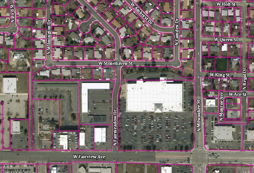
14 VICINITY MAP 12 DRAFT /BOI /CUP /DRH
15 SITE PLAN 13 DRAFT /BOI /CUP /DRH
16 anticipated to be generated by the school and update all other impacted analyses based on those number and resubmit to staff for review. 8. The trip distribution provided in the submitted study is the same as was presented to staff in an regarding the zip code analysis on July 17, In response staff suggested the following: Please make the distributions clear relative to the study intersections (i.e., what portion is to/from north on Milwaukee, south on Milwaukee, east on Fairview, and west on Fairview). I suspect this will change your trip distribution patterns. Please consider that not all trips will be round trip from the students homes. Many may be diverted trips from work and shopping. For example, in the morning a larger proportion of trips may leave the school going eastbound on Fairview than trips entering the school from the east. It does not appear that these suggestions were taken into consideration, as only the trip distribution of where the parents are traveling from to reach the school was provided. A second trip distribution analysis should be provided for the AM peak hour which shows how parents will exit the school site and continue onto work or other destinations. It is unlikely that 70 % of the exiting vehicles will travel turn west on to Fairview and travel south on Maple Grove. 9. The exiting vehicles shown on Figure 6A (pg11) does not match Table 2C (pg9). Please revise either the figure or the table and resubmit to staff for review. 10. The overall V/C ratio for the Fairview/ Milwaukee intersection should be provided on Tables 3A and 3B. 11. The V/C ratio for the minor approach of the Fairview/Fairmeadow and Milwaukee/Middlefield intersection should be provided on Tables 3A and 3B. 12. A street segment analysis was not provided as part of the submitted study. Based on the trip distribution an estimate how much traffic will be added to the study roadways should be included as part of the traffic impact study. This information should be provided for both the AM and PM peak hours under total traffic condition in a table similar to Table 1. This information will be important during the ACHD Commission meeting when area property owners will want to know how much traffic is anticipated to increase on their streets due to the school. 13. The TIS notes that Fairmeadow is a local street on page 5, but it is referred to as a collector on page 15. Fairmeadow is a local roadway and collector street standards do not apply. 14. Page 15 mentions a proposed driveway onto Fairview Avenue. Staff is not supportive of and will not recommend a driveway onto Fairview Avenue, as this site has frontage and access onto a lesser classified roadway, Fairmeadow. This was discussed during our June 22, 2014 meeting. 15. The title of Figure 8 reads Left Turn Lane, it should be Right Turn Lane, please revise. 16. The TIS notes that a right turn lane is warranted at the Fairview/Fairmeadow intersection, but that it cannot be constructed due to right-of-way constraints. There is an existing right turn Ada County Highway District 3775 Adams Street Garden City, ID PH FX
17 lane at this intersection. The study should be revised to reflect this and resubmitted to staff for review. 17. The study recommends that Fairmeadow be striped for simultaneous left and right turns on to Fairview Avenue. Is there enough right-of-way to accommodate this? Will any on-street parking need to be removed? 18. Staff disagrees with the discussion on page 16, which notes that traffic problems are more pronounced during the PM peak hour. It is staffs experience that the AM peak hour is the critical time due to parents needing to get to work after dropping off their kids at school. 19. Staff is concerned that only 220-feet of storage is proposed to serve the school when the TIS notes that 1,000-feet of storage is necessary during drop-off/pick-up times. Staff is not supportive of the suggested 24-foot wide (two 12-foot lanes) drop-off loop. This would create an unsafe condition by directing kids to cross in front of vehicles in the outside lane to access the school, while those vehicles (outside loop) may be trying to merge into the inside loop to by-pass and exit the site. 20. As mentioned above staff is concerned that only 220-feet of storage is proposed to serve the school when the TIS notes that 1,000-feet of storage is necessary. The study also notes that 100 vehicles will turn left onto Fairview from Fairmeadow in the AM peak hour with an average delay of 50 seconds per vehicle. It is likely that parents may drop kids off north of the school in the neighborhood and cut-through. This should be addressed as it is likely that entire 440- feet of Fairmeadow north of Fairview will be congested during the AM peak hour. 21. Based on the Fairview Avenue Access Management Plan and Concept Design Fairmeadow will be restricted to right-in/right-out only in the future. The TIS does not tell us how those 100 left turning trips will be redistributed at that time. Please address this and resubmit to staff for review. 22. The site plan provided as part of the development application for the school notes a future phase; however this is not referenced in the TIS. Information regarding the future expansion of the school should be included in the TIS to provide a complete understanding of future traffic conditions and any necessary mitigation. Please let me know if you have any questions. Sincerely, Mindy Wallace, AICP Planner III Development Services CC: City of Boise Cody Riddle City of Boise Leon Letson Cole Architects Stan Cole Ada County Highway District 3775 Adams Street Garden City, ID PH FX
18 Committed to Service John S. Franden, President Mitchell A. Jaurena, Vice President Rebecca W. Arnold, Commissioner Sara M. Baker, Commissioner Jim D. Hansen, Commissioner September 29, 2014 Dan Thompson Thompson Engineers 181 East 50 th Street Garden City, ID Subject: Village Charter School Traffic Impact Study The Ada County Highway District (ACHD) staff has completed a review of the submitted traffic impact study (TIS) for the Village Charter School. The list below includes required items that were not addressed in the TIS, as requested in ACHD s July 31, 2014 completeness review letter, as well as other items found during the full review of the TIS. The primary issue which needs to be addressed is the reported need for 1,000-feet of storage as stated in the TIS during drop-off/pick-up times when only 220-feet of storage is proposed to serve the school. This issue was raised in ACHD s July 31, 2014 Completeness Review letter and still needs to be addressed. If there is not enough storage then where are the parents going for dropoff/pick-up; the neighborhood north of the site or the Winco parking lot? Please address the following items and resubmit the TIS for review. 1. Road System Are there any parking restrictions on Fairmeadow or Middlefield? 2. Count data - AM turn counts and daily counts for Milwaukee/Middlefield and Fairview/Fairmeadow intersection, are not provided in the appendix. Why was Fairview east of Mitchell selected as the count location on Fairview instead of west of Milwaukee? Please include the traffic count data in the appendix and explain the traffic count location on Fairview. 3. Trip Generation - State that daily trip generation estimates for this land use are not available rather than include an empty and incomplete table (2A). 4. Diverted trips how was 30% determined? If diverted trip estimates are assumed, the travel routes need to be clearly established (they aren t currently). Per the ITE Trip Generation Handbook, 3 rd Edition: o Diverted trips are often difficult to identify. Consequently, diverted trips should be estimated in a traffic impact study only if: Reliable data reporting the percentage distribution of the three types of trips (primary, pass-by, and diverted trips) are available for the land use(s) being considered; and The travel routes for diverted trips can be clearly established. Ada County Highway District 3775 Adams Street Garden City, ID PH FX
19 5. Traffic Distribution On July 18 th ( ) and July 31 st (letter) ACHD provided comments regarding the distribution pattern and they have not yet been sufficiently addressed. 6. Existing Retail Trips ACHD is OK with the traffic study subtracting traffic associated with the existing site in the future scenario with the proposed school; however, we request the subtracted volumes to be based upon measured counts (not estimates) at the study intersections. The existing site has an access on Fairview and many of the trips associated with the existing development may never use Fairmeadow. Furthermore, it is impossible to subtract more existing retail trips than currently exist. 7. Traffic Operations the delay and LOS at the Fairview/Fairmeadow intersection with mitigation should reflect the critical lane (like the V/C) so the values are actually (F and 67.2). Typically when an intersection operates at LOS F, a roundabout/signal warrant analysis should be completed. However, Fairmeadow is located too close to Milwaukee to allow for signalization. Instead the TIS should be revised to note that the intersection fails and then go on to address the impacts. 8. Intersection Analysis the statement, All of the intersections under study are anticipated to function at an acceptable LOS through the total AM and PM peak hour traffic conditions in the build out year of 2015 is false. The Fairview/Fairmeadow intersection requires mitigation and still operates at LOS F, and the Fairview/Milwaukee intersection (overall intersection and WBLT movement) exceed acceptable parameters in all analyzed PM peak hour scenarios. 9. Roadway Analysis Based on the information provided, we cannot support the idea that traffic on Fairmeadow will decrease with the project and fall below the 1,000 vehicle threshold (see above discussion on existing retail trips). Table 5 is mislabeled as daily traffic counts. It appears that these volumes are based on the turn count data. A roadway analysis is necessary for the AM AND PM peak hour. A roadway analysis is necessary for Fairmeadow and Middlefield (please include these facilities in the evaluation table). Local Commercial streets have a threshold of 8,500 ADT. The Local Street threshold of 1,000 ADT should only be used in residential neighborhoods and does not apply abutting the site. 10. Internal Circulation Please clarify that the asserted more pronounced problem that occurs during the PM peak hour is queuing. Please also describe the fact the AM problem is also of concern because there is typically more traffic during a similar duration resulting in congestion, conflicts, and queues. Page 17 it looks like the discussion was not completed in the 2 nd paragraph. o Staff remains very concerned that only 220-feet of storage is proposed to serve the school when the TIS notes that 1,000-feet of storage is necessary. It is likely that parents may drop kids off in the neighborhood and cut-through. This should be addressed as it is likely that the entire 440-feet of Fairmeadow north of Fairview will be congested during the AM and PM peak hours. 11. Idaho Code: o The statements, Students will be brought by automobile and fewer than 10% of the 300 students will walk or ride bicycles do not completely jive. How many students are anticipated to walk and/or ride bicycles? o School zone what is Boise School District Policy regarding school zones? Why should a school speed zone be included on Fairmeadow given few kids will walk to Ada County Highway District 3775 Adams Street Garden City, ID PH FX
20 school and the posted speed is 20mph? If we establish a school speed zone, the ACHD standard is to use school zone flashing beacons (not signs). o o o o o Anticipated future improvements & Access Control on Adjacent Highways & Proposed Projects in vicinity some discussion and evaluation on what may result if the Fairmeadow intersection with Fairview is restricted to right-in/right-out is necessary. As identified in the Fairview Access Management Plan, medians in the TIS study area are identified in the concept study. Management_Strategy_ _ReducedSize.pdf How can students be prohibited from crossing Fairview except at signalized intersections? How can that be enforced? Internal circulation Prior to approval of the TIS, an access and circulation plan should be included in this report, not developed as discussed in this report. Zoning in the vicinity please discuss the zoning in the project vicinity (commercial and residential), not the zoning of the site. Striping and Signing Modifications Are changes to on-street parking and development of two southbound lanes on Fairmeadow not recommended? Any crosswalks? School zones? 12. Cut Through The travel time analysis is flawed and over simplified. For example, it does not assume any delay associated with a 1,000 queue packed into a congested 220 long queuing area. 13. Mitigation Measures Are separate southbound turn lanes on Fairmeadow not recommended? A barrier on Fairmeadow Drive north of the school cannot be installed. A no left-turn sign at the school driveways will not stop parents from avoiding the parking lot and dropping off their children on Fairmeadow and driving on the local streets. 14. Conclusions a) The development will generate more than 189 and 125 new trips in the study area the diverted trips need to be included. b) Fairview/Milwaukee traffic operations see above discussion. c) Fairview Access management need to identify the possibility of no left-turns at Fairmeadow. d) Fairview/Fairmeadow operates at LOS F with the site and mitigation. e) If dedicated turn lanes are recommended on Fairmeadow need to discuss impacts to on-street parking. f) Middlefield/Cut-through, conclusion may change when account for discussion above. g) Report does not mitigate the fact that the site does not provide sufficient queuing capacity. Ada County Highway District 3775 Adams Street Garden City, ID PH FX

21 Please let me know if you have any questions. Sincerely, Mindy Wallace, AICP Planner III Development Services CC: City of Boise Cody Riddle City of Boise Leon Letson Cole Architects Stan Cole Ada County Highway District 3775 Adams Street Garden City, ID PH FX
22 Request for Reconsideration of Commission Action 1. Request for Reconsideration of Commission Action: A Commissioner, a member of ACHD staff or any other person objecting to any final action taken by the Commission may request reconsideration of that action, provided the request is not for a reconsideration of an action previously requested to be reconsidered, an action whose provisions have been partly and materially carried out, or an action that has created a contractual relationship with third parties. a. Only a Commission member who voted with the prevailing side can move for reconsideration, but the motion may be seconded by any Commissioner and is voted on by all Commissioners present. If a motion to reconsider is made and seconded it is subject to a motion to postpone to a certain time. b. The request must be in writing and delivered to the Secretary of the Highway District no later than 3:00 p.m. on the day prior to the Commission s next scheduled regular meeting following the meeting at which the action to be reconsidered was taken. Upon receipt of the request, the Secretary shall cause the same to be placed on the agenda for that next scheduled regular Commission meeting. c. The request for reconsideration must be supported by written documentation setting forth new facts and information not presented at the earlier meeting, or a changed situation that has developed since the taking of the earlier vote, or information establishing an error of fact or law in the earlier action. The request may also be supported by oral testimony at the meeting. d. If a motion to reconsider passes, the effect is the original matter is in the exact position it occupied the moment before it was voted on originally. It will normally be returned to ACHD staff for further review. The Commission may set the date of the meeting at which the matter is to be returned. The Commission shall only take action on the original matter at a meeting where the agenda notice so provides. e. At the meeting where the original matter is again on the agenda for Commission action, interested persons and ACHD staff may present such written and oral testimony as the President of the Commission determines to be appropriate, and the Commission may take any action the majority of the Commission deems advisable. f. If a motion to reconsider passes, the applicant may be charged a reasonable fee, to cover administrative costs, as established by the Commission. 16 DRAFT /BOI /CUP /DRH
TRAFFIC STUDY GUIDELINES Clarksville Street Department
 TRAFFIC STUDY GUIDELINES Clarksville Street Department 9/1/2009 Introduction Traffic studies are used to help the city determine potential impacts to the operation of the surrounding roadway network. Two
Committed to Service
 Development Services Department Committed to Service TO: FROM: Ada County Highway District Commissioners Mindy Wallace, AICP Planner III COMISSION HEARING: January 27, 2016 SUBJECT: Syringa Valley Specific
5.0 Roadway System Plan
 Southwest Boise Transportation Study Page 16 5.0 Roadway System Plan The Roadway System Plan outlines roadway improvements in the Initial Study Area. It forecasts future deficiencies on the arterial system,
Traffic Impact Analysis Chatham County Grocery Chatham County, NC
 Chatham County Grocery Chatham County, NC TABLE OF CONTENTS 1. INTRODUCTION... 1 1.1. Location and Study Area... 1 1.2. Proposed Land Use and Access... 2 1.3. Adjacent Land Uses... 2 1.4. Existing ways...
TRAFFIC IMPACT STUDY CRITERIA
 Chapter 6 - TRAFFIC IMPACT STUDY CRITERIA 6.1 GENERAL PROVISIONS 6.1.1. Purpose: The purpose of this document is to outline a standard format for preparing a traffic impact study in the City of Steamboat
Clackamas County Comprehensive Plan
 ROADWAYS The County s road system permits the movement of goods and people between communities and regions, using any of a variety of modes of travel. Roads provide access to virtually all property. They
Committed to Service
 Development Services Department Committed to Service January 19, 2016 TO: FROM: SUBJECT: ACHD Board of Commissioners Mindy Wallace, AICP Planner III Kirsten Subdivision/BPP15-0023 Executive Summary: The
Glenn Avenue Corridor Traffic Operational Evaluation
 Glenn Avenue Corridor Traffic Operational Evaluation PREPARED FOR: THE CITY OF AUBURN PREPARED BY: DECEMBER 2007 Glenn Avenue Corridor Study--Auburn, Alabama TABLE OF CONTENTS Introduction... 1 Background
Traffic Impact Study. Westlake Elementary School Westlake, Ohio. TMS Engineers, Inc. June 5, 2017
 TMS Engineers, Inc. Traffic Impact Study Westlake Elementary School Westlake, Ohio June 5, 2017 Prepared for: Westlake City Schools - Board of Education 27200 Hilliard Boulevard Westlake, OH 44145 TRAFFIC
ACHD Board of Commissioners Stacey Yarrington, Planner III Tandem Ridge/ EPP / PP-07-16/ RZ-12-16/ CPA-01-16/ A-07-16
 Development Services Department DATE: December 14, 2016 TO: FROM: SUBJECT: ACHD Board of Commissioners Stacey Yarrington, Planner III Tandem Ridge/ EPP16-0012/ PP-07-16/ Executive Summary: This is an annexation,
Transportation Impact Study for Abington Terrace
 Transportation Impact Study for Abington Terrace Abington Township, Montgomery County, PA Sandy A. Koza, P.E., PTOE PA PE License Number PE059911 Prepared by McMahon Associates, Inc. 425 Commerce Drive,
Committed to Service
 Committed to Service Paul Woods, President Rebecca W. Arnold, Vice President Sara M. Baker, Commissioner Jim D. Hansen, Commissioner Kent Goldthorpe, Commissioner March 14, 2017 Planning and Programming
Committed to Service. Development Services. February 21, ACHD Commission. Mindy Wallace, AICP
 Committed to Service Sara M. Baker, President Rebecca W. Arnold, Vice President Jim D. Hansen, Commissioner Kent Goldthorpe, Commissioner Paul Woods, Commissioner February 21, 2018 Development Services
Committed to Service
 Committed to Service Sherry R. Huber, President Rebecca W. Arnold, Vice President John S. Franden, Commissioner Carol A. McKee, Commissioner Sara M. Baker, Commissioner To: From: ACHD Commissioners, Director,
Drag and drop pic and stretch/crop to the limits of the blue rectangle (delete this text box) Maxey Elementary School
 Maxey Elementary School") Drag and drop pic and stretch/crop to the limits of the blue rectangle (delete this text box) Maxey Elementary School SCHOOL ROUTE PLAN For MAXEY ELEMENTARY SCHOOL LOCATION 33 ORANGE COUNTY Prepared for:
Drag and drop pic and stretch/crop to the limits of the blue rectangle (delete this text box) Maxey Elementary School SCHOOL ROUTE PLAN For MAXEY ELEMENTARY SCHOOL LOCATION 33 ORANGE COUNTY Prepared for:
QUICKIE C STORE AND GAS BAR 1780 HERON ROAD OTTAWA, ONTARIO TRANSPORTATION BRIEF. Prepared for:
 QUICKIE C STORE AND GAS BAR 1780 HERON ROAD OTTAWA, ONTARIO TRANSPORTATION BRIEF Prepared for: Quickie Convenience Stores Larny Holdings Ltd. c/o PBC Group April 15, 2015 115-615 Report_1.doc D. J. Halpenny
Committed to Service
 Development Services Department Committed to Service June 30, 2014 TO: FROM: SUBJECT: ACHD Board of Commissioners Christy Little Planning Review Supervisor Victory Middle School/MCUP-14-003 DATE: July
TRAFFIC IMPACT ANALYSIS
 TRAFFIC IMPACT ANALYSIS FOR THE CHAMPAIGN UNIT#4 SCHOOL DISTRICT PROPOSED HIGH SCHOOL (SPALDING PARK SITE) IN THE CITY OF CHAMPAIGN Final Report Champaign Urbana Urbanized Area Transportation Study 6/24/2014
OFFICE/RETAIL DEVELOPMENT 1625 BANK STREET OTTAWA, ONTARIO TRANSPORTATION BRIEF. Prepared for: Canada Inc.
 OFFICE/RETAIL DEVELOPMENT 1625 BANK STREET OTTAWA, ONTARIO TRANSPORTATION BRIEF Prepared for: 9402209 Canada Inc. December 15, 2015 115-625 Report_2.doc D. J. Halpenny & Associates Ltd. Consulting Transportation
Traffic Impact Memorandum. May 22, 2018
 BISHOP PROFESSIONAL DEVELOPMENT BUILDING Proposed Land-use Change & Parking Modification 3601 SW 31st Street Topeka, Kansas 66614 CFS Project No. 185077 Traffic Impact Memorandum May 22, 2018 Prepared
3.0 PROJECT DESCRIPTION
 The following section of the Draft EIR contains a description of the proposed Elk Grove Boulevard/SR 99 Interchange Modification project, consistent with the requirements of CEQA Guidelines Section 15124.
To: ACHD Commissioners and Director 3/14/2017. Peer Review of Highlands Neighborhood Traffic and Pedestrian Safety Plan Information Briefing
 Paul Woods, President Rebecca W. Arnold, Vice President Kent Goldthorpe, Commissioner Sara M. Baker, Commissioner Jim D. Hansen, Commissioner MEMORANDUM Engineering To: ACHD Commissioners and Director
Peer Review of Highlands Neighborhood Traffic and Pedestrian Safety Plan
 FINAL REPORT March 14, 2017 Prepared for: Ada County Highway District Prepared by: SIX MILE ENGINEERING, PA Executive Summary The (Highlands Safety Plan) developed by the Ada County Highway District (ACHD)
Caltrans Sloat Boulevard Pedestrian Safety Project Response to Community Questions, Comments & Concerns
 Caltrans Sloat Boulevard Pedestrian Safety Project Response to Community Questions, Comments & Concerns Revised: May 10, 2016 The California Department of Transportation (Caltrans) is planning various
TRAFFIC ACTION PLAN. Laurie Meadows Neighborhood CITY OF SAN MATEO
 TRAFFIC ACTION PLAN Laurie Meadows Neighborhood CITY OF SAN MATEO Draft January 2017 Table of Contents Introduction... 2 The Traffic Forum Process... 5 Neighborhood Traffic Issues... 7 Neighborhood Recommendations
 Development Services Department Project/File: Lead Agency: Site address: Fall Creek Subdivision (MPP-12-016) This is a preliminary plat application to subdivision approximately 110 acres into 296 residential
THIS PAGE LEFT BLANK INTENTIONALLY
 GA SR 25 Spur at Canal Road Transportation Impact Analysis PREPARED FOR GLYNN COUNTY, GEORGIA 1725 Reynolds Street, Suite 300 Brunswick, Georgia 31520 PREPARED BY 217 Arrowhead Boulevard Suite 26 Jonesboro,
Traffic Impact Analysis Walton Acres at Riverwood Athletic Club Clayton, NC
 Traffic Impact Analysis Walton Acres at Riverwood Athletic Club Clayton, NC 1. TABLE OF CONTENTS INTRODUCTION...1 1.1. Site Location and Study Area...1 1.2. Proposed Land Use and Site Access...2 1.3.
SECTION 1 - TRAFFIC PLANNING
 SECTION 1 - TRAFFIC PLANNING 1.1 TRAFFIC OPERATIONS 1.1.1 Roadway Functional Classification The Multnomah County Comprehensive Framework Plan s Policy 34: Trafficways and the Functional Classification
Traffic Impact Study WestBranch Residential Development Davidson, NC March 2016
 Traffic Impact Study WestBranch Residential Development Davidson, NC March 216 TRAFFIC IMPACT STUDY FOR THE WestBranch Residential Development LOCATED IN DAVIDSON, NC Prepared For: Lennar Carolinas, LLC
1609 E. FRANKLIN STREET HOTEL TRAFFIC IMPACT STUDY EXECUTIVE SUMMARY
 1609 E. FRANKLIN STREET HOTEL TRAFFIC IMPACT STUDY EXECUTIVE SUMMARY Prepared for: The Town of Chapel Hill Public Works Department Traffic Engineering Division Prepared by: HNTB North Carolina, PC 343
Los Altos Hills Town Council - June 18, 2015 Palo Alto City Council June 22, AGENDA ITEM #2.B Presentation
 Los Altos Hills Town Council - June 18, 2015 Palo Alto City Council June 22, 2015 AGENDA ITEM #2.B Presentation Previous Presentations Los Altos Hills Town Council in May 2014 and February 2015 Palo Alto
TOWN OF PAYSON TRAFFIC CALMING MANUAL
 TOWN OF PAYSON TRAFFIC CALMING MANUAL APPROVED BY THE PAYSON TOWN COUNCIL SEPTEMBER 6, 2007 TOWN OF PAYSON TRAFFIC CALMING POLICY 1.0 Introduction Traffic Calming involves retrofitting physical devices
TRAFFIC IMPACT STUDY COMPREHENSIVE UPDATE TOWN OF THOMPSON S STATION, TENNESSEE PREPARED FOR: THE TOWN OF THOMPSON S STATION
 TRAFFIC IMPACT STUDY COMPREHENSIVE UPDATE TOWN OF THOMPSON S STATION, TENNESSEE PREPARED FOR: THE TOWN OF THOMPSON S STATION Transportation Consultants, LLC 1101 17 TH AVENUE SOUTH NASHVILLE, TN 37212
City of Homewood Transportation Plan
 City of Homewood Transportation Plan Prepared for: City of Homewood, Alabama Prepared by: Skipper Consulting, Inc. May 2007 TABLE OF CONTENTS INTRODUCTION... 1 BACKGROUND INFORMATION... 1 EXISTING TRANSPORTATION
4.12 TRANSPORTATION Executive Summary. Setting
 4.12 TRANSPORTATION 4.12.1 Executive Summary This section is based on the Multimodal Transportation Impact Study (TIS; 2016) prepared by Omni-Means, Ltd. to evaluate projected transportation impact conditions
Traffic Study North Shore School District 112
 Traffic Study North Shore School District 112 Proposed Expansion of Northwood Junior High School Prepared By: May 1, 2015 1. Introduction Kenig, Lindgren, O Hara, Aboona, Inc. (KLOA, Inc.) has been retained
BOI / DRH S. 13 th Street Mixed use office/retail development with residential dormitory
 Jim D. Hansen, President Sara M. Baker, Vice President Rebecca W. Arnold, Commissioner Kent Goldthorpe, Commissioner Paul Woods, Commissioner October 21, 2015 To: Rick Nesser ISS River Partners, LLC 8312
Lake Whitney Elementary School
 Lake Whitney Elementary School SCHOOL ROUTE PLAN For LAKE WHITNEY ELEMENTARY SCHOOL LOCATION 18 ORANGE COUNTY Prepared for: ORANGE COUNTY SCHOOL ASSESSMENT PROGRAM ORANGE COUNTY PUBLIC WORKS Traffic Engineering
Traffic Impact Study Little Egypt Road Development Denver, North Carolina June 2017
 Traffic Impact Study Little Egypt Road Development Denver, North arolina June 2017 N. Little Egypt Road DQ\ QDQFLQJ VDOHV RU RWKHU SHUIRUPDQFH EDVHG FULWHULD Proposed Site Driveways Site Driveway 1 TRAFFI
4.0 TRAFFIC IMPACT STUDIES
 SECTION 4 4.0 TRAFFIC IMPACT STUDIES 4.1 TRAFFIC IMPACT STUDY REQUIREMENTS The City has established Traffic Impact Study (TIS) requirements for the purpose of ensuring that both the quantitative and qualitative
City of Wayzata Comprehensive Plan 2030 Transportation Chapter: Appendix A
 A1. Functional Classification Table A-1 illustrates the Metropolitan Council s detailed criteria established for the functional classification of roadways within the Twin Cities Metropolitan Area. Table
Summary: Mercer County Princeton Avenue & Spruce Street Study January 2009
 Summary: Several recent studies have assessed potential development and redevelopment opportunities in the Mercer Crossing area of Trenton, Ewing, and Lawrence. This Princeton Avenue and Spruce Street
Sebastopol Charter School Traffic Management Plan
 Sebastopol Charter School The serves as the working document in support of these essential goals: to ensure the safety and efficiency of student arrival to and departure from school to ensure the safety
TRAFFIC ACTION PLAN. North Central Neighborhood CITY OF SAN MATEO
 TRAFFIC ACTION PLAN North Central Neighborhood CITY OF SAN MATEO Draft February 2017 Table of Contents Introduction... 1 The Traffic Forum Process... 4 Neighborhood Traffic Issues... 6 Neighborhood Recommendations
Traffic Circulation Study for Neighborhood Southwest of Mockingbird Lane and Airline Road, Highland Park, Texas
 ARIZONA TEXAS NEW MEXICO OKLAHOMA February 13, 2015 Mr. Meran Dadgostar P.E., R.S. Town of Highland Park 4700 Drexel Dr. Highland Park, Texas 75205 Re: Traffic Circulation Study for Neighborhood Southwest
Capital Region Council of Governments
 March 23, 2018 Capital Region Council of Governments PROJECT CONCEPT REPORT Realignment of Swamp and Northfield Road s approaches to Route 44 (Boston Turnpike) Town of Coventry SUMMARY: The Town of Coventry
TRANSPORTATION ANALYSIS REPORT US Route 6 Huron, Erie County, Ohio
 TRANSPORTATION ANALYSIS REPORT US Route 6 Huron, Erie County, Ohio December 12, 2012 Prepared for: The City of Huron 417 Main Huron, OH 44839 Providing Practical Experience Technical Excellence and Client
INTRODUCTION THOROUGHFARE SYSTEM CLASSIFICATIONS
 INTRODUCTION The thoroughfare plan will assist public officials in the development of a specialized system for efficient and safe movement of vehicular traffic while minimizing potential conflicts with
Donahue Drive Corridor Traffic Operational Evaluation
 Donahue Drive Corridor Traffic Operational Evaluation PREPARED FOR: THE CITY OF AUBURN PREPARED BY: JANUARY 2007 Donahue Drive Corridor Study--Auburn, Alabama TABLE OF CONTENTS Introduction... 1 Background
TRAFFIC ASSESSMENT River Edge Colorado
 TRAFFIC ASSESSMENT River Edge Colorado Submitted by: Fehr & Peers 621 17th Street, Ste. 231 Denver, CO 8293 (33) 296-43 December, 21 App. M-2 Traffic Assessment River Edge Colorado December 21 TABLE OF
TRAFFIC IMPACT STUDY. Creekside Thornton, Colorado. For. August 2015 November 2015 Revised: August Prepared for:
 TRAFFIC IMPACT STUDY For Creekside Thornton, Colorado August 215 November 215 Revised: August 216 Prepared for: Jansen Strawn Consulting Engineers 45 West 2 nd Avenue Denver, Colorado 8223 Prepared by:
July 5, Arthur R. Ware, Jr. Elementary School 2017 Safe Routes to School Walkabout Report
 July 5, 2017 Arthur R. Ware, Jr. Elementary School 2017 Safe Routes to School Walkabout Report 1 Walkabout Report Introduction On April 28, 2017, City, School, and SAWMPO staff met to conduct a Safe Routes
TENW Transportation Engineering NorthWest
 TENW Transportation Engineering NorthWest MEMORANDUM DATE: May 16, 2018 PRELIMINARY DRAFT TO: FROM: SUBJECT: Angelie Stahlnecker City of Fircrest Jeff Schramm TENW Response to Comments from City of Tacoma
Access Management Regulations and Standards
 Access Management Regulations and Standards January 2014 Efficient highway operation Reasonable property access Concept of Access Management The way to manage access to land development while preserving
Figure 1: East West Connector Alignment Alternatives Concept Drawing
 Page 2 of 9 Figure 1: East West Connector Alignment Alternatives Concept Drawing The Montebello Drive extension will run north south and connect Wilsonville Road to the Boones Ferry Road to Brown Road
Princeton Avenue and Spruce Street Transportation and Site Access Enhancements Project
 Princeton Avenue and Spruce Street Transportation and Site Access Enhancements Project Mercer County Planning Division AECOM Transportation (formerly DMJM Harris) January 29, 2009 Agenda Project Status
Focused Traffic Analysis for the 200 Nellen Avenue Project
 March 13, 2017 Mr. Phil Boyle Town of Corte Madera 300 Tamalpais Drive Corte Madera, CA 94976-0159 Focused Traffic Analysis for the 200 Nellen Avenue Project Dear Mr. Boyle; W-Trans has completed a focused
Orange Center Elementary School
 Drag and drop pic and stretch/crop to the limits of the blue rectangle (delete this text box) Orange Center Elementary School Drag and drop pic and stretch/crop to the limits of the blue rectangle (delete
City of Seattle Edward B. Murray, Mayor
 City of Seattle Edward B. Murray, Mayor Department of Transportation Scott Kubly, Director Eastlake Community Council 117 E Louisa St. #1 Seattle, WA 98102-3278 January 28, 2016 RE: Roosevelt to Downtown
Roadway Classification Design Standards and Policies. Pueblo, Colorado November, 2004
 Roadway Classification Design Standards and Policies Pueblo, Colorado November, 2004 Table of Contents Page Chapter 1. General Provisions 1.1 Jurisdiction 3 1.2 Purpose and Intent 3 1.3 Modification 3
FRONT RANGE CROSSINGS TRAFFIC IMPACT STUDY
 FRONT RANGE CROSSINGS TRAFFIC IMPACT STUDY Prepared for: City of Thornton And Colorado Department of Transportation Prepared by: 11 Blake Street, Suite 2 Denver, Colorado 822 Contact: Brian Bern, PE, PTOE
TOWN OF CHAPEL HILL POLICY AND PROCEDURES FOR TRAFFIC CALMING MEASURES
 TOWN OF CHAPEL HILL POLICY AND PROCEDURES FOR TRAFFIC CALMING MEASURES (Adopted by the Town Council on June 30, 2004) (Revised December 6, 2010) (Revised February 8, 2016) POLICY AND PROCEDURES FOR TRAFFIC
Hidden Oaks Elementary School
 Hidden Oaks Elementary School SCHOOL ROUTE PLAN For HIDDEN OAKS ELEMENTARY SCHOOL LOCATION 13 ORANGE COUNTY Prepared for: ORANGE COUNTY SCHOOL ASSESSMENT PROGRAM ORANGE COUNTY PUBLIC WORKS Traffic Engineering
CHAPTER 4 TRANSPORTATION IMPACT STUDY TABLE OF CONTENTS
 CHAPTER 4 TRANSPORTATION IMPACT STUDY TABLE OF CONTENTS Section Title Page 4.1 Introduction... 4-1 4.1.1 General... 4-1 4.1.2 Applicant Responsibility... 4-1 4.1.3 Capacity and Safety Issues... 4-1 A.
Gene Dillon Elementary School Traffic Study Division Street Site
 To: From: Dr. James Hess, Superintendent Jordan Schwarze, PE, Senior Engineer Matt Pacyna, PE, Senior Associate Date: March 30, 2016 Subject: Gene Dillon Elementary School Traffic Study reet Site Memorandum
WISCONSIN AVENUE EXTENSION SECOND PUBLIC INFORMATION MEETING. March 28, 2017
 WISCONSIN AVENUE EXTENSION SECOND PUBLIC INFORMATION MEETING March 28, 2017 STUDY AREA N MEETING AGENDA Introductions Study Background Alternatives Studied Recommended Alternative Discussion STUDY BACKGROUND
Community Transportation Plan
 Community Transportation Plan Appendix A: Traffic Calming CITY OF DECATUR COMMUNITY TRANSPORTATION PLAN Appendix A: City of Decatur City-wide Residential Traffic Calming Program Process & Procedures The
TRAFFIC IMPACT STUDY And A TRAFFIC SIGNAL WARRANT ANALYSIS FOR A SENIOR LIVING AND APARTMENT DEVELOPMENT
 TRAFFIC IMPACT STUDY And A TRAFFIC SIGNAL WARRANT ANALYSIS FOR A SENIOR LIVING AND APARTMENT DEVELOPMENT DEERFIELD TOWNSHIP, WARREN COUNTY, OHIO Nantucket Circle and Montgomery Road () Prepared for: ODLE
CITY OF COCONUT CREEK IMPLEMENTATION GUIDELINES FOR TRAFFIC CALMING
 CITY OF COCONUT CREEK IMPLEMENTATION GUIDELINES FOR TRAFFIC CALMING I. Introduction: The City of Coconut Creek recognizes that the conditions of residential streets can greatly affect neighborhood livability;
Magnolia Place. Traffic Impact Analysis. Prepared for: City of San Mateo. Prepared by: Hexagon Transportation Consultants, Inc.
 Magnolia Place Traffic Impact Analysis Prepared for: City of San Mateo Prepared by: Hexagon Transportation Consultants, Inc. Updated January 4, 2010 Table of Contents 1. Introduction...1 2. Existing Conditions...6
Henderson Avenue Mixed-Use Development
 Zoning Case: Z145-3 Traffic Impact Analysis Henderson Avenue Mixed-Use Development Dallas, TX October 26 th, 216 Kimley-Horn and Associates, Inc. Dallas, Texas Project #644827 Registered Firm F-928 Traffic
BPP / SUB
 Development Services Department Project/File: Lead Agency: Site address: Millwell Place Subdivision/ BPP15-0031/ SUB15-0064 This is a preliminary plat application to allow for the development of 68 building
 Development Services Department Project/File: Lead Agency: Site address: Aralar Park/SUB13-00048 This is a preliminary plat application to construct 55 buildable lots and 6 common lots on 12.67 acres.
Arlington Public Schools Thomas Jefferson Site Evaluation Transportation Networks. Thomas Jefferson Working Group Meeting #6 November 10, 2014
 Arlington Public Schools Thomas Jefferson Site Evaluation Transportation Networks Thomas Jefferson Working Group Meeting #6 November 10, 2014 2 3 INTRODUCTION 4 Goal of our work: Identify and assess multi-modal
5858 N COLLEGE, LLC N College Avenue Traffic Impact Study
 5858 N COLLEGE, LLC nue Traffic Impact Study August 22, 2016 Contents Traffic Impact Study Page Preparer Qualifications... 1 Introduction... 2 Existing Roadway Conditions... 5 Existing Traffic Conditions...
INDUSTRIAL BUILDING 3009 HAWTHORNE ROAD CITY OF OTTAWA TRANSPORTATION OVERVIEW REVISED. Prepared for: Canada Inc.
 INDUSTRIAL BUILDING 3009 HAWTHORNE ROAD CITY OF OTTAWA TRANSPORTATION OVERVIEW REVISED Prepared for: 7849648 Canada Inc. Octiober 1, 2015 114-598 Overview_2.doc D. J. Halpenny & Associates Ltd. Consulting
Bridge Street Corridor Study Report
 Bridge Street Corridor Study Report Prepared for: Prepared by: BRIDGE STREET CORRIDOR STUDY REPORT PREPARED FOR: CITY OF ARROYO GRANDE COMMUNITY DEVELOPMENT DEPARTMENT 300 EAST BRANCH STREET ARROYO GRANDE,
SCHOOL TRAFFIC ASSESSMENT
 PK# 2415-17.387 Z178-150 TRAFFIC IMPACT ANLAYSIS: SCHOOL TRAFFIC ASSESSMENT Project: In Dallas, Texas Prepared for: City of Dallas On behalf of: Dallas Independent School District Prepared by: Hunter W.
City of Charlottesville Traffic Calming Handbook
 City of Charlottesville Traffic Calming Handbook July 2008 CITY OF CHARLOTTESVILLE NEIGHBORHOOD DEVELOPMENT SERVICES Telephone: (434)970-3182 Fax: (434) 970-3359 Introduction The City of Charlottesville
BPP / SUB /CAR /PUD
 Development Services Department Project/File: Lead Agency: Site address: Roe Street Townhomes/ BPP16-0023/ SUB16-00046/CAR16-00023/PUD16-00022 This is a rezone, preliminary plat, and planned unit development
DEPARTMENT OF ENVIRONMENTAL SERVICES. North Harrison Street (Lee Highway to Little Falls Road) Comparative Analysis. Prepared for:
 Comparative Analysis. Prepared for:") DEPARTMENT OF ENVIRONMENTAL SERVICES North Harrison Street (Lee Highway to Little Falls Road) Comparative Analysis Prepared for: Arlington County Department of Environmental Services 2100 Clarendon Boulevard,
DEPARTMENT OF ENVIRONMENTAL SERVICES North Harrison Street (Lee Highway to Little Falls Road) Comparative Analysis Prepared for: Arlington County Department of Environmental Services 2100 Clarendon Boulevard,
Highway 49, Highway 351 and Highway 91 Improvements Feasibility Study Craighead County
 Highway 49, Highway 351 and Highway 91 Improvements Feasibility Study Craighead County Executive Summary March 2015 Highway 49, Highway 351 and Highway 91 Improvements Feasibility Study Craighead County
Committed to Service
 Committed to Service Kent Goldthorpe, President Paul Woods, Vice President Rebecca W. Arnold, Commissioner Sara M. Baker, Commissioner Jim D. Hansen, Commissioner May 24, 2017 Development Services TO:
City of Elizabeth City Neighborhood Traffic Calming Policy and Guidelines
 City of Elizabeth City Neighborhood Traffic Calming Policy and Guidelines I. Purpose: The City of Elizabeth City is committed to ensure the overall safety and livability of residential neighborhoods. One
Complete Street Analysis of a Road Diet: Orange Grove Boulevard, Pasadena, CA
 Complete Street Analysis of a Road Diet: Orange Grove Boulevard, Pasadena, CA Aaron Elias, Bill Cisco Abstract As part of evaluating the feasibility of a road diet on Orange Grove Boulevard in Pasadena,
Traffic Calming Policy
 Article I. Purpose and Goal. The purpose of this policy is to establish criteria and procedures the City will use to evaluate requests for, and if appropriate, implement traffic calming measures. Neighborhood
Development Services Department
 Kent Goldthorpe, President Paul Woods, Vice President Rebecca W. Arnold, Commissioner Sara M. Baker, Commissioner Jim D. Hansen, Commissioner July 21, 2016 Development Services Department To: From: ACHD
Table 1: Recommended Interim Improvement and Long Term Improvement/ROW Preservation Proposed Improvements. Recommended Interim Improvement
 Rebecca W. Arnold, President Sara M. Baker, Vice President John S. Franden, Commissioner Carol A. McKee, Commissioner Mitchell Jaurena, Commissioner June 19, 2012 Planning & Programming Department TO:
SCHOOL CROSSING PROTECTION CRITERIA
 CITY OF MADISON TRAFFIC ENGINEERING SCHOOL CROSSING PROTECTION CRITERIA January 2016 Adopted as Policy on August 31, 1976, by Common Council by Amended Resolution #29,540 Amended on September 14, 1976,
ALLEY 24 TRAFFIC STUDY
 ALLEY 24 TRAFFIC STUDY in City of Frostburg, Maryland January 2013 3566 Teays Valley Road Hurricane, WV Office: (304) 397-5508 www.denniscorporation.com Alley 24 Traffic Study January 2013 Frostburg, Maryland
A plan for improved motor vehicle access on Railroad Avenue in Provincetown
 A plan for improved motor vehicle access on Railroad Avenue in Provincetown February 2011 A plan for improved motor vehicle access on Railroad Avenue in Provincetown INTRODUCTION AND PROBLEM IDENTIFICATION
Draft Traffic Calming Policy Paper
 Draft Traffic Calming Policy Paper What is Traffic Calming The term traffic calming is defined differently throughout the United States. The Institute of Transportation Engineers, an international educational
Traffic Impact Study. Roderick Place Columbia Pike Thompson s Station, TN. Transportation Group, LLC Traffic Engineering and Planning
 F i s c h b a c h Transportation Group, LLC Traffic Engineering and Planning Traffic Impact Study Roderick Place Columbia Pike Thompson s Station, TN Prepared March 2016 Ms. Gillian L. Fischbach, P.E.,
COMMERCIAL DEVELOPMENT 2015 ROBERTSON ROAD OTTAWA, ONTARIO TRANSPORTATION BRIEF. Prepared for:
 COMMERCIAL DEVELOPMENT 2015 ROBERTSON ROAD OTTAWA, ONTARIO TRANSPORTATION BRIEF Prepared for: First Bay Properties Inc. 311 Richmond Road, Suite 203 Ottawa, ON K1Z 6X3 August 8, 2017 117-663 Brief_1.doc
City of Memphis On-Street Parking Modification Guidelines
 City of Memphis Effective Date: December 1, 2013 Bicycle/Pedestrian Program 125 N. Main Street Memphis, TN 38103 (901) 576-6710 www.bikepedmemphis.com City of Memphis Executive Summary It is current practice
List of Attachments. Location Map... Site Plan... City of Lake Elsinore Circulation Element... City of Lake Elsinore Roadway Cross-Sections...
 List of Attachments Exhibits Location Map... Site Plan... City of Lake Elsinore Circulation Element... City of Lake Elsinore Roadway Cross-Sections... Existing Lane Geometry and Traffic Controls... Existing
3.9 - Transportation and Traffic
 Transportation and Traffic 3.9 - Transportation and Traffic This section describes the potential transportation and traffic effects of project implementation on the project site and its surrounding area.
Meadow Woods Elementary School
 Drag and drop pic and stretch/crop to the limits of the blue rectangle (delete this text box) Meadow Woods Elementary School Drag and drop pic and stretch/crop to the limits of the blue rectangle (delete
SETTINGS AND OPPORTUNITIES MOBILITY & ACCESS
 7 mobility & access how do people use el camino what is it like to drive on el camino/to park along el camino what is the pedestrian experience like what is the role of transit along the corridor what