EASTERN SHORE OF VIRGINIA PEDESTRIAN FACILITIES STUDY
|
|
|
- Valerie Collins
- 5 years ago
- Views:
Transcription

1 EASTERN SHORE OF VIRGINIA PEDESTRIAN FACILITIES STUDY Inventory and Needs Assessment December 2017 Mason Avenue, Cape Charles Prepared by: Accomack-Northampton Planning District Commission
2 This Page Intentionally Left Blank Eastern Shore of Virginia Pedestrian Facilities Study 2017
3 EASTERN SHORE OF VIRGINIA PEDESTRIAN FACILITIES STUDY Inventory and Needs Assessment December 2017 Prepared for: Virginia Department of Transportation Hampton Roads District 1700 North Main Street Suffolk, Virginia Prepared by: Accomack Northampton Planning District Commission Front Street Accomac, Virgnia (757) Funding provided by Virginia Department of Transportation UPC The Accomack-Northampton Planning District Commission wants to thank VDOT staff for their assistance in developing this study.

4 Table of Contents Executive Summary. page 1 Introduction. page 2 Methodology page 2-3 Analysis pages 4-7 Recommendations and Next Steps. page 8 Towns/Villages Maps. page 9-34 Market Street, Onancock
, functional but not ADA-compliant (2), and non-functional (3).")
5 Executive Summary The goal of this study was to develop a complete inventory of pedestrian facilities, sidewalks and crosswalks, on the Eastern Shore of Virginia. In order to prioritize which facilities need to be repaired or replaced first, sidewalks were categorized as ADA-compliant (1), functional but not ADA-compliant (2), and non-functional (3). Crosswalks were also located. Both were then mapped for each town and village, and miles and the percentages of each category were tabulated. Forty-six percent of the sidewalks in the study were deemed non-functional (3) for ADA-compliance. Most of those were installed prior to 1991 and the Americans with Disabilities Act. The largest percentage of sidewalks (49%) are now in the functional but not ADA-compliant category (2) and were installed after The newest standards for ADA-compliance changed again in 2011, with the result that only 6% of all VDOT-maintained sidewalks fall into the ADA-compliant category. Those towns that had Category 1 ADA-compliant sidewalks also had crosswalks connecting them except for Exmore and Accomac. Six new crosswalks could be painted between Exmore s sidewalks on Main Street, Bank Avenue, and Commercial Avenue. The Town of Accomac has one location between ADAcompliant sidewalks that could also be painted for a crosswalk. A needs assessment for all towns and counties will begin by sending this study to mayors and councils. Upon request, A-NPDC will assist the towns in identifying priorities. According to VDOT records for the Hampton Roads area, one mile of new sidewalk costs between $382,000 and $1.2 million. Finding construction funding will be an ongoing effort by VDOT, the jurisdictions, the A-NPDC, and other agencies. Main Street, Chincoteague - 1 -

6 Introduction The purpose of this study was to determine the location and adequacy of pedestrian facilities and to prioritize replacement or repair of those that are inadequate by presenting the study to VDOT and the local jurisdictions on Virginia s Eastern Shore. The Accomack-Northampton Planning District Commission (A-NPDC) received funding from the Virginia Department of Transportation (VDOT) under its Highway Planning and Construction program to finance the activities contained in the FY 2018 Scope of Work. One of the activities was to work with the towns to develop prioritized pedestrian needs assessment, including GIS sidewalk inventory, crosswalk needs, and prioritized pedestrian needs for each town. This study includes public sidewalks that are maintained by VDOT as well as private sidewalks such as those found in housing developments, medical centers, and schools. Methodology Sidewalks were located using Google Earth or Street Maps as well as field verification where details could not be determined from the aerial images. In addition, some sidewalks were upgraded recently and did not yet appear in the Google products. Those were field verified as well. Each section of sidewalk was examined for compliance with the Americans with Disabilities Act (ADA) of In order to qualify as ADA-compliant, a sidewalk must be 5-feet wide not including the curb, have ramps that include bubbles for the sight-impaired, and must include flares on ramps and driveway cuts. Crosswalks are ADA-compliant if they connect two sections of ADA-compliant sidewalk. Sidewalks were determined to be in one of three categories: 1. ADA Compliant 5-feet wide not including the curb, bubbles on ramps, and flares at ramps and driveway cuts. No utility poles in sidewalk. This view also shows a crosswalk connecting two Category 1 sidewalks on Market Street in Onancock. (from Google Maps/Streetview). 2. Functional, but not fully ADA-compliant - at least 3 feet wide, includes flares and ramps, but not bubbled, and ramps may be narrower than the rule. No utility poles in sidewalk. This view is Market Street and College Avenue in Onancock. A crosswalk connects two Category 2 sidewalks

, and maps of the categorized sidewalks were developed for towns and villages to prioritize improvements.")
7 3. Non-functional - less than 3 feet wide, missing ramps and/or flares, utility poles in sidewalk, broken, heaved, etc. Any one of these conditions qualifies the sidewalk for this category. This view is Justis Street in Onancock. 4. Existing crosswalks were mapped and a table with locations appears on page 7. Each section of sidewalk and each crosswalk was then mapped and assigned to a category using ArcGIS. An aggregate table was built (see tables on pages 6-7), and maps of the categorized sidewalks were developed for towns and villages to prioritize improvements. Maps are presented in alphabetical order by county and incorporated town or un-incorporated village name. See page 9 for a key to maps
8 Analysis Sidewalks There are a total of 68.3 miles of VDOT-maintained sidewalks in both counties including 40.7 miles in Accomack County and 27.6 miles in Northampton County. There are an additional 6.5 miles of non- VDOT-maintained sidewalks mostly at schools, medical and assisted living centers, private developments, and commercial sites such as Walmart in Onley. Of the total VDOT-maintained miles, only 4.2 miles (6%) are ADA compliant (category 1), 33.2 miles (49%) are functional but not ADA-compliant (category 2), and 31.1 miles (45%) are in category 3 nonfunctional under ADA rules. Most of the miles of sidewalks in the region were installed by VDOT before 1990 when ADA regulations were not in place. After 1991, when the regulations became effective, ramps and flares and three feet of width was mandated. Sidewalks installed by VDOT after 1991 are now mostly category 2, as the regulations changed again in Legislation became effective in The latest regulations require bubbles on ramps for sight-impaired pedestrians and wider widths. Sidewalks installed after 2012 are Category 1 ADA-compliant. Of the total non-vdot maintained sidewalks, 51% are ADA-compliant, 46% are functional but not ADAcompliant, and 3% are non-functional. This higher percentage of ADA-compliant and functional sidewalks is attributed to the fact that the majority of these sidewalks were installed more recently than the VDOTmaintained sidewalks. Following on the next two pages are the tabular data for sidewalks on the Eastern Shore of Virginia
9 Towns and Villages Maintained by VDOT Towns and Villages Total Miles Category 1 Total Miles Category 2 Total Miles Category 3 Total Sidewalk % of Total in Total % of Total in Total Sidewalk % of Total in Miles Jurisdiction Sidewalk Jurisdiction Miles Jurisdiction Crosswalks Category 4 Number VDOT Maintained Eastern Shore Totals % % % 0.37 Accomack County % % % 0.29 Accomac % % % 0 Atlantic* % % 0 Belle Haven % % 0 0% 0 Bloxom % 0 0% % 0 Chincoteague % % % 0.22 Greenbackville* % 0 0% % 0 Greenbush* % 0 0% % 0 Hallwood % % % 0 Keller 0 0 0% % 0 Mappsville* % % 0 Melfa % % 0 0% 0 Nelsonia* % % % 0 New Church* % % % 0 Oak Hall* % 0 0% % 0 Onancock % % % 0.07 Onley % % % 0 Painter 0 0 0% 0 0% 0 0% 0 Parksley % % % 0 Saxis % 0 0% % 0 Tangier 0 0 0% 0 0% 0 0% 0 Tasley* 0 0 0% 0 0% 0 0% 0 Temperanceville* % 0.1 9% % Wachapreague % % 0 0% 0 Northampton County % % % 0.09 Cape Charles % % % 0.07 Cheriton % % % 0 Eastville % % % 0.01 Exmore % % % 0 Franktown* % % % 0 Nassawadox % % % 0 *villages Total Miles Inventoried Sidewalks - 5 -
10 Locations Not Maintained by VDOT Crosswalks Total Miles Total Miles Category 1 Total Miles Category 2 Total Miles Category 3 Category 4 Inventoried Total Sidewalk Total Total Sidewalk Sidewalks % of Total % of Total % of Total Number Locations Miles Sidewalk Miles Accawmacke ES % 0 0% 0 0% 0 Arcadia HS % 0 0% 0 0% 0 Arcadia MS % 0 0% 0 0% 0 Atlantic CHC % 0 0% 0 0% 0 Bay Creek, Cape Charles % 0 0% 0 0% 0 Bayview Community HC % 0 0% 0 0% 0 Chincoteague ES % % % 0.03 Chincoteague HS % % 0 0% 0 Eastern Shore Community College % 0 0% 0 0% 0 The Hermitage % % 0 0% 0 Kegotank ES % % % 0 King's Bay, Cape Charles % % 0 0% 0 Kiptopeke ES % 0 0% 0 0% 0 Metompkin ES % % 0 0% 0 Nandua HS % % 0 0% 0 Nandua MS % 0 0% 0 0% 0 Northampton MS % 0 0% % 0 Northampton HS % 0 0% 0 0% 0 Occohannock ES % 0 0% 0 0% 0 Pungoteague ES % % % 0 Riverside Shore Memorial Hospital % % 0 0% 0 Shore Life % % 0 0% 0 Shore Medical Center % % 0 0% 0 Onley CHC % 0 0% 0 0% 0.02 Walmart, Onley % 0 0% 0 0% 0 Category 1 Category 2 Category 3 Category 4 ADA-Compliant Functional but non-ada Non Functional Crosswalks Notes: Heritage Hall, Nassawadox mapped in town totals Chincoteague Community Health Center mapped in town totals County totals include both incorporated and non-incorporated towns Franktown CHC has no sidewalks - 6 -
11 Crosswalks Crosswalks were mapped as well. Most of them connect category 2 sidewalks (functional, but not ADAcompliant) in the towns of Chincoteague, Eastville, and Onancock. Under the 2011 ADA rules, only Category 1 sidewalk intersections can have crosswalks installed. Category 1 sidewalks that could have crosswalks painted between them were found in Accomac (1) across Business Route 13 between Cross Street and Courthouse Avenue, and in Exmore (6), between the two sidewalks on Bank Avenue and Commercial Avenue and between those two streets and the far side of Business Route 13 (Main Street). Cape Charles, Chincoteague, Onancock and Exmore have more crosswalks than other towns in the region. Cape Charles has the most ADA-compliant crosswalks as a result of that town s efforts building a community walking trail financed in part by the Transportation Equity Act (formerly TEA-21 now MAP-21 Moving Ahead for Progress in the 21st Century). Details of crosswalks as they connect between categories of sidewalks: Towns/Villages Cat 1-1 Cat 1-2 Cat 2-2 Cat 2-3 Locations for additional crosswalks Accomac Cross St & Courthouse Rd on Business Route 13 Atlantic Belle Haven Bloxom Cape Charles Cheriton Chincoteague Eastville Exmore Bank & Commercial Avenues & Business Route 13 Franktown Greenbackville Greenbush Hallwood Mappsville Melfa Nelsonia Oak Hall Onancock Onley Parksley Temperanceville Wachapregue (Note: no crosswalks were found between category 3 sidewalks) - 7 -
12 Recommendations & Next Steps Short Term: Town of Accomac paint one crosswalk across Business Route 13 between Cross Street and Courthouse Avenue. Town of Exmore paint six crosswalks between Category 1 sidewalks at Bank and Commercial Avenue intersections with Business Route 13 and between both sides of those streets. This study points out that a 46 percent of Eastern Shore sidewalks are not useable by disabled persons. In order to identify which sidewalks should be upgraded first, or where sidewalks and crosswalks could be added to facilitate use by disabled persons, each jurisdiction will need to decide how or if it wishes to address the deficiencies identified in this study. To begin the needs assessment, each jurisdiction will receive a copy of this study, and A-NPDC staff will make presentations to the jurisdictions governing bodies upon request and help each develop its priorities. Information from the jurisdictions will be added to this study as it is available. To address identified priorities to bring sidewalks up to ADA-compliance, additional funding will need to be found. According to VDOT, one mile of new sidewalk costs between $382,000 and $1.2 million depending upon the several factors such as whether utilities need to be relocated or additional right-of-way needs to be acquired. Therefore, replacing all miles of non-functional Category 3 sidewalks owned and maintained by VDOT is not remotely feasible in the near future. Our local VDOT Residency has maintenance funds only, which it uses to replace sidewalks only when a road is resurfaced. It does not have funding for new construction. Therefore, our jurisdictions will need to prioritize those sections of sidewalk they want replaced and assist VDOT in finding the funds needed to effect the improvements. Potential funding sources include: 1. Virginia Department of Housing and Community Development Community Development Block Grant ( 2. Moving Ahead for Progress in the 21 st Century (MAP VDOT Revenue Sharing Program ( 4. VDOT Maintenance Funds ( 5. Private/Public Partnerships ( Mid- to Late-Term and ongoing: Add priorities collected from jurisdictions as updates to this study, and assist VDOT and jurisdictions in obtaining funding for improved pedestrian facilities and additions as requested
13 Maps ACCOMACK COUNTY TOWNS Incorporated: Page Un-Incorporated: Page Accomac 10 Atlantic 11 Belle Haven 12 Greenbackville 16 Bloxom 13 Greenbush 17 Chincoteague Mappsville 19 Hallwood 18 Nelsonia 21 Melfa 20 Oak Hall 22 Onancock Temperanceville 27 Onley 25 Parksley 26 Wachapreague 28 In Accomack County, there are several incorporated towns without sidewalks. Therefore, they were not mapped. They are Keller, Painter, Saxis, and Tangier. NORTHAMPTON COUNTY TOWNS Incorporated: Page Un-Incorporated: Page Cape Charles 29 Franktown 33 Cheriton 30 Eastville 31 Exmore 32 Nassawadox 34 In Northampton County, there are several un-incorporated villages such as Oyster and Willis Wharf. They are not included here because they do not have sidewalks

14 ACCOMAC 10

15 ATLANTIC Red = Category 1 ADA Compliant Blue = Category 2 Functional Purple = Category 3 Nonfunctional Green = Category 4 - Crosswalks 11

16 BELLE HAVEN 12

17 BLOXOM Key to Sidewalks Red = Category 1 ADA Compliant Blue = Category 2 Functional Purple = Category 3 Non-functional Green = Category 4 - Crosswalks 13
18 CHINCOTEAGUE - South 14

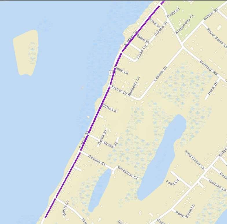
19 TOWN CHINCOTEAGUE OF CHINCOTEAGUE - North - North Purple = Category 3 Nonfunctional 15
20 GREENBACKVILLE 16

21 GREENBUSH 17

22 HALLWOOD 18
23 MAPPSVILLE 19
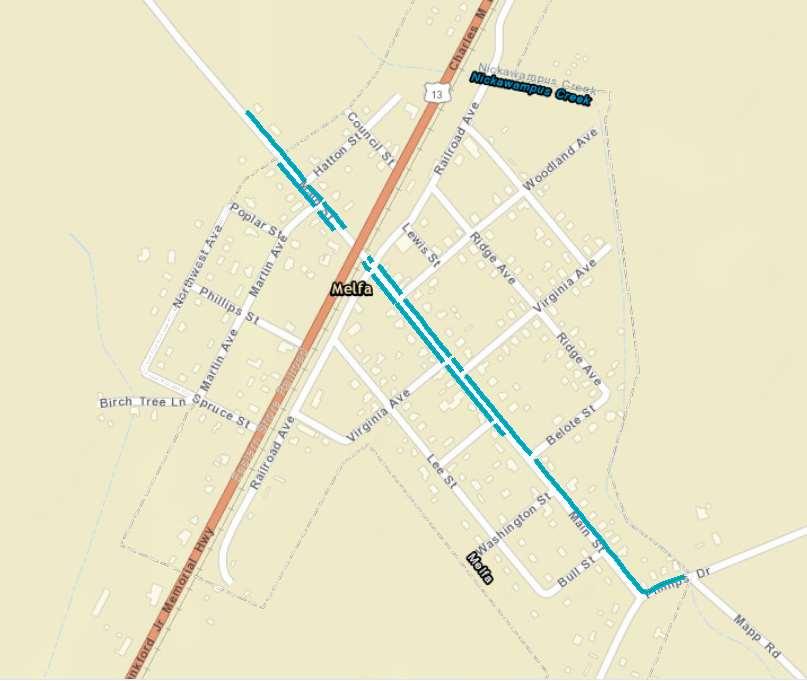
24 MELFA 20

25 NELSONIA 21

26 OAK HALL Purple = Category 3 Nonfunctional 22

27 ONANCOCK West of College Avenue 23

28 ONANCOCK East of College Avenue 24
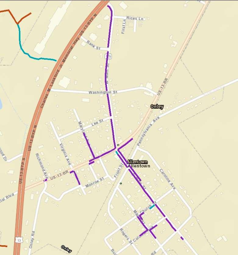
29 ONLEY 25

30 PARKSLEY 26
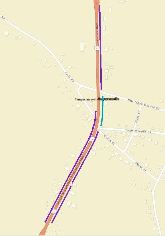
31 TEMPERANCEVILLE 27
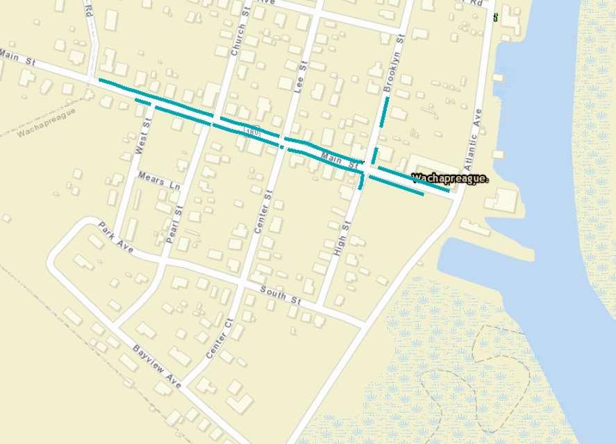
32 WACHAPREAGUE 28

33 CAPE CHARLES 29

34 CHERITON 30

35 EASTVILLE 31
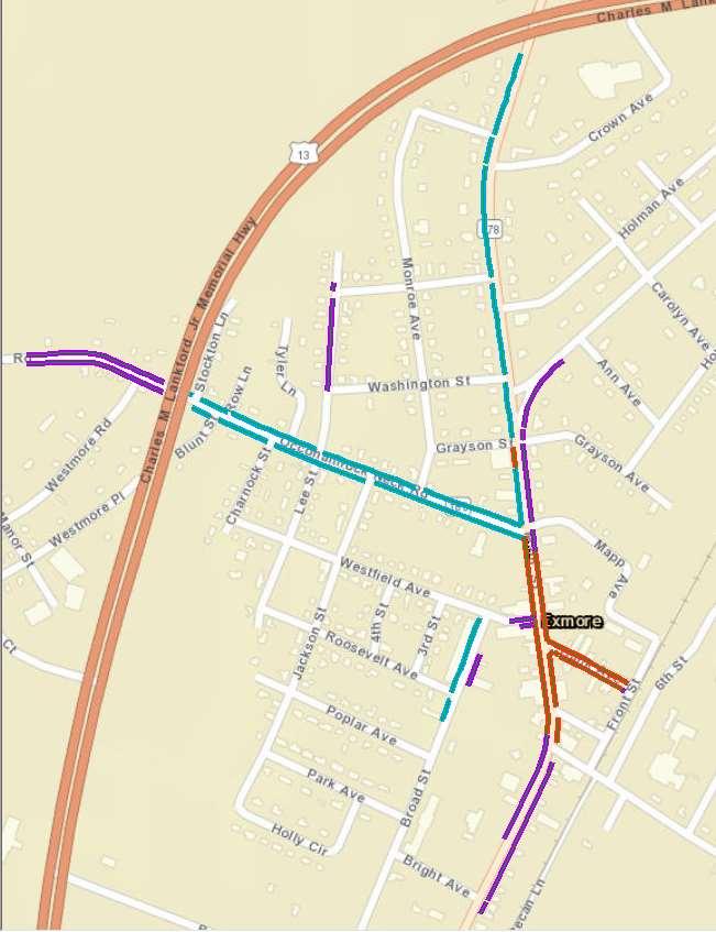
36 EXMORE 32

37 FRANKTOWN 33
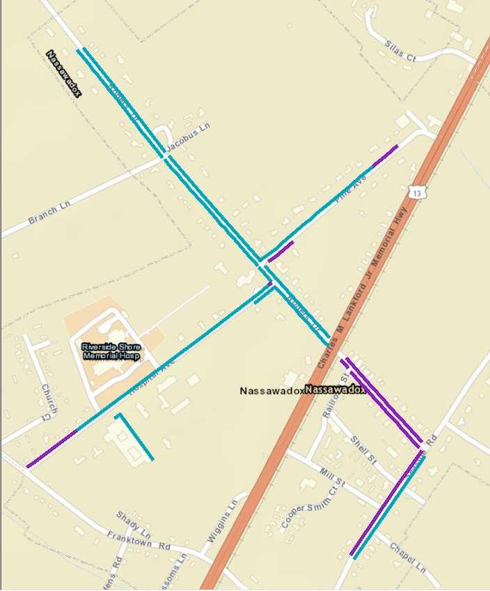
38 NASSAWADOX 34
39 For additional information contact: Transportation Program Manager Accomack-Northampton Planning District Commission Front Street P.O. Box 417 Accomac, VA x
EASTERN SHORE OF VIRGINIA BICYCLE PLAN
 EASTERN SHORE OF VIRGINIA BICYCLE PLAN April 2011 Prepared by the Eastern Shore of Virginia Bicycle Committee (2004 edition) and the Technical Transportation Advisory Committee (2011 update) of the Accomack-Northampton
Please forward comments, suggestions, and corrections to or
 Seven Easy Walks on the Eastern Shore Creating walking trails with signage on existing sidewalks or paths is an easy way for towns to encourage resident health as well as economic development when these
EASTERN SHORE ALTERNATIVE TRANSPORTATION MODE STUDY FOR DISABLED, ELDERLY, LOW-INCOME, AND YOUTH POPULATION
 EASTERN SHORE ALTERNATIVE TRANSPORTATION MODE STUDY FOR DISABLED, ELDERLY, LOW-INCOME, AND YOUTH POPULATION Accomack-Northampton Planning District Commission Eastern Shore of Virginia Transportation Technical
ADA Transition Plan. City of Gainesville FY19-FY28. Date: November 5, Prepared by: City Of Gainesville Department of Mobility
 ADA Transition Plan FY19-FY28 Date: November 5, 2018 Prepared by: City Of Gainesville Department of Mobility 1.0 INTRODUCTION 1.1 BACKGROUND The federal statute known as the Americans with Disabilities
REGIONAL LONG RANGE. Please visit the VDOT website to find additional information regarding this and other. Ocean. Atlantic. Parksley.
 A C C O M A C K - N O R T H A MCheriton PTON PLANNING DISTRICT COMMISSION DRAFT 2011 1 Eastville Nassawadox Town of Chincoteague Belle Haven Chesapeake Wachapreague Parksley R e g i o n Onley a l L o n
ADA TRANSITION PLAN 2013
 ADA TRANSITION PLAN 2013 TABLE OF CONTENTS Contents Introduction 1 Purpose 2 Identified Obstacles to the Public Right of Way 3 Criteria for Determining Impediments at Village Facilities 4 Removing Barriers
EASTERN SHORE BIKE PLAN UPDATE 2014
 EASTERN SHORE BIKE PLAN UPDATE 2014 Cyclers see considerable more of this beautiful world than any other class of citizens. A good bicycle, well applied, will cure most ills this flesh is heir to. ~ Dr.
EASTERN SHORE OF VIRGINIA WALKABLE COMMUNITIES INITIATIVE
 EASTERN SHORE OF VIRGINIA WALKABLE COMMUNITIES INITIATIVE TWO FEET AND TWO WHEELS CAN TRAVEL: CREATING WALK AND BIKE FRIENDLY COMMUNITIES PRESENTED BY RICH MORRISON ACCOMACK COUNTY PLANNING DIRECTOR EASTERN
IMPLEMENTATION STRATEGIES
 GEORGETOWN SIDEWALK MASTER PLAN 34% of funding is dedicated to Downtown Overlay District sidewalks 28% of funding is recommended within 1/4 mile of Southwestern University 26% of funding is recommended
Americans with Disabilities Act Transition Plan for Public Right-of-Way Improvements
 Americans with Disabilities Act Transition Plan for Public Right-of-Way Improvements Prepared by: Public Works Department Engineering Division October 2015 Table of Contents Section I Introduction.. 3
AMERICANS WITH DISABILITIES ACT TRANSITION PLAN LEON COUNTY FOR CURB RAMPS AND SIDEWALKS DEPARTMENT OF PUBLIC WORKS. 1 P age
 AMERICANS WITH DISABILITIES ACT TRANSITION PLAN FOR CURB RAMPS AND SIDEWALKS 2015 LEON COUNTY DEPARTMENT OF PUBLIC WORKS 1 P age INTRODUCTION The goal of the Americans with Disabilities Act (ADA) Transition
Pedestrian, Bicycle and Traffic Calming Strategic Implementation Plan. January 18, 2011
 Pedestrian, Bicycle and Traffic Calming Strategic Implementation Plan January 18, 2011 Tonight s Agenda Receive update on project Provide feedback on two policy issues Complete Streets Policy Project Prioritization
8 Transportation. 8.1 Introduction
 8 Transportation 8.1 Introduction Since the Northampton County Comprehensive Plan was updated in 2001, several major transportation studies and planning efforts have been completed, including the U.S.
FY 2016 TRANSPORTATION ALTERNATIVES PROGRAM PROJECT SELECTION
 AGENDA ITEM #8: FY 2016 TRANSPORTATION ALTERNATIVES PROGRAM PROJECT SELECTION The Transportation Alternatives Program (TAP) created by MAP-21 requires that 50% of the program funds received by the state
2 History & Geography. 2.1 Geography The Delmarva Peninsula
 2 History & Geography 2.1 Geography 2.1.1 The Delmarva Peninsula The Delmarva Peninsula is a large peninsula on the east coast that contains land within the three states of Delaware, Maryland, and Virginia.
TRANSPORTATION ALTERNATIVES PROGRAM: SELECTED PROJECTS AND FUNDING ALLOCATIONS
 ITEM #9: TRANSPORTATION ALTERNATIVES PROGRAM: SELECTED PROJECTS AND FUNDING ALLOCATIONS The Transportation Alternatives Program (TAP) created by MAP-21 requires that 50% of the program funds received by
CITY MANUALS AND STANDARDS REVIEW
 GEORGETOWN SIDEWALK MASTER PLAN CITY MANUALS AND STANDARDS REVIEW RESOURCES AND STANDARDS As part of the Master Plan process, a review and evaluation of current City documents and policies relevant to
AGENDA ITEM SUMMARY SPECIAL AGENDA ITEM NO. _1A_
 AGENDA ITEM SUMMARY AGENCY: City Council MEETING DATE: June 25, 2012 DEPARTMENT: Community Dev PREPARED BY: T Spade DEPT. DIR. APPROVAL: MJ CITY MGR. APPROVAL: LR PRESENTED BY: T Spade TITLE: RECEIVE REPORT
Montclair s Complete Streets Experience
 Presented by: Hon. Jerry Fried, Mayor Montclair Township About Montclair Six square miles Six commuter rail stations Four local bus routes (NJ Transit) Two private commuter bus routes Five business districts
TULSA CITY COUNCIL CAPITAL IMPROVEMENT PROGRAM TASK FORCE MEETING JANUARY
 CITY OF TULSA BICYCLE & PEDESTRIAN INFRASTRUCTURE TULSA CITY COUNCIL CAPITAL IMPROVEMENT PROGRAM TASK FORCE MEETING JANUARY 31, 2013 CITY OF TULSA ENGINEERING SERVICES DEPARTMENT CITY OF TULSA ADA TRANSITION
Lynchburg District Update
 Lynchburg District Update Virginia Statewide Bicycle and Pedestrian Advisory Committee Spring Meeting May 16 th, 2017 David Cook Transportation Planner, VDOT Lynchburg District Table of Contents Active
TOWN OF PORTLAND, CONNECTICUT COMPLETE STREETS POLICY
 TOWN OF PORTLAND, CONNECTICUT COMPLETE STREETS POLICY I. VISION, GOALS & PRINCIPLES VISION To improve the streets of Portland making them safer and more accessible for all users including pedestrians,
Agenda. Overview PRINCE GEORGE S PLAZA METRO AREA PEDESTRIAN PLAN
 PRINCE GEORGE S PLAZA METRO AREA PEDESTRIAN PLAN May 28, 2008 Agenda Welcome and introductions Project overview and issue identification Planning context and strengths Design challenges and initial recommendations
Final Sidewalk Feasibility Study
 Garfield Drive From Anastasia Drive to Elizabeth Place City of South Daytona July 23, 2009 Final Sidewalk Feasibility Study Prepared for: Prepared by: Final Sidewalk Feasibility Study Garfield Drive 2
Fiscal Year 2017 Bicycle and Pedestrian Metric Report
 Fiscal Year 2017 Bicycle and Pedestrian Metric Report November 2017 In 2015, the Virginia Department of Transportation s (VDOT) implementation of the 2004 Commonwealth Transportation Board s (CTB) Policy
Sidewalk Task Force. Presented By: Date: Don Dey, Transportation Engineer. January 26, 2007
 Sidewalk Task Force Presented By: Don Dey, Transportation Engineer Date: January 26, 2007 Introduction Task Force members Meeting Schedule Special Guests Sidewalks Causes & Priorities Sidewalk Maintenance
DPW Order No:
 DPW Order No: 184350 ESTABLISHING REGULATIONS AND GUIDELINES FOR THE EVALUATION AND CONSTRUCTION OF NEW CURB RAMPS OR RECONSTRUCTION/UPGRADE OF EXISTING CURB RAMPS AND ADDITIONAL PEDESTRIAN SAFETY IMPROVEMENTS
TRAFFIC ACTION PLAN. Laurie Meadows Neighborhood CITY OF SAN MATEO
 TRAFFIC ACTION PLAN Laurie Meadows Neighborhood CITY OF SAN MATEO Draft January 2017 Table of Contents Introduction... 2 The Traffic Forum Process... 5 Neighborhood Traffic Issues... 7 Neighborhood Recommendations
Draft. Lecompton. Table of Contents. Background
 Lecompton Table of Contents Existing Infrastructure 80 Funding 82 Policy and Program Recommendations 83 Infrastructure Implementation Scenarios 84 Conclusion 85 Douglas County Lecompton Background Located
VILLAGE OF DOWNERS GROVE ADA TRANSITION PLAN
 VILLAGE OF DOWNERS GROVE ADA TRANSITION PLAN January 2017 The Village of Downers Grove s strategic goals include Exceptional Municipal Services and Top Quality Infrastructure. This document, which evaluates
Pedestrian Improvements Prepared by Neighborhood Development Services November 2012
 Pedestrian Improvements 2004-2013 Prepared by Neighborhood Development Services November 2012 Pedestrian Facilities On-going Pedestrian Safety Initiatives (2004 present) New sidewalk construction Safe
Roundabouts: The Virginia Experience AASHTO SCOTE June 20, 2012
 Roundabouts: The Virginia Experience 2012 AASHTO SCOTE June 20, 2012 Virginia Virginia's Highway System 57,867 miles of statemaintained system 1,118 miles of Interstate 8,111 miles of Primaries 48,305
Town of Bourbon. Americans with Disabilities Act Transition Plan: Pedestrian Facilities in the Public Right-of-Way
 Town of Bourbon Americans with Disabilities Act Transition Plan: Pedestrian Facilities in the Public Right-of-Way Table of Contents Introduction... 1 Legal Requirements... 1 Identified Obstacles to the
Attached for your reference please find project updates on ongoing VDOT construction projects in Southampton County.
 SOUTHAMPTON COUNTY BOARD OF SUPERVISORS Regular Session i July 25, 2016 6. HIGHWAY MATTERS A. PLAN PROJECT UPDATES Attached for your reference please find project updates on ongoing VDOT construction projects
NM-POLICY 1: Improve service levels, participation, and options for non-motorized transportation modes throughout the County.
 Transportation PRINCE WILLIAM COUNTY 2008 COMPREHENSIVE PLAN NON-MOTORIZED PLAN CONTENTS Goals, Policies, and Action Strategies Table 4 (Bike Facility Classifications and Descriptions) Table 5 (Bike Facility
Scenarios. The following slides will show existing pictures that deny access, followed by a retrofitted picture that provides access.
 Scenarios. The following slides will show existing pictures that deny access, followed by a retrofitted picture that provides access. For the following slides assume an overlay project and provide pedestrian
Urbana Pedestrian Master Plan
 Urbana Pedestrian Master Plan Recommendations Gabe Lewis, Transportation Planner Champaign County Regional Planning Commission November 15, 2018 Public Meeting #2 Public Input Round #1 Thank You! 10 public
PRINCE GEORGE S PLAZA METRO AREA PEDESTRIAN PLAN
 PRINCE GEORGE S PLAZA METRO AREA PEDESTRIAN PLAN May 28, 2008 Agenda Welcome and introductions Project overview and issue identification Planning context and strengths Design challenges and initial recommendations
WELCOME. Thank you for joining us at the Second Public Workshop for the Carlsbad Pedestrian Master Plan. We look forward to receiving your feedback.
 City of Carlsbad Pedestrian Master Plan: WELCOME WELCOME Please Sign In Provide Input at Flip Charts Review Boards Presentation of Draft Plan Thank you for joining us at the Second Public Workshop for
Engineering City of Fort Collins Sidewalk Prioritization Model
 Engineering City of Fort Collins Sidewalk Prioritization Model Version 2.1 December 8, 2017 Table of Contents Table of Contents... i Introduction and Background... 1 Relationship to other plans... 1 History
Houma-Thibodaux Metropolitan Planning Organization STP<200K Funding Application APPLICATION
 APPLICATION HOUMA-THIBODAUX METROPOLITAN PLANNING ORGANIZATION (HTMPO) FOR SURFACE TRANSPORTATION PROGRAM (STP
HYATTSVILLE TRANSPORTATION PLAN. City Council Update March 19, 2018
 HYATTSVILLE TRANSPORTATION PLAN City Council Update March 19, 2018 AGENDA PROJECT GOALS DATA COLLECTION WHAT WE LEARNED NEXT STEPS PROJECT GOALS Identify bicycle and pedestrian needs of the city Evaluate
DRAFT. Lecompton. Table of Contents. Background
 Lecompton Table of Contents Existing Infrastructure 98 Funding 100 Policy and Program Recommendations 102 Infrastructure Recommendations 104 Conclusion 109 Douglas County Lecompton Background Located at
DRAFT. Table of Contents. Background
 Douglas County Table of Contents Existing Infrastructure 86 Funding 89 Policy and Program Recommendations 90 Infrastructure Recommendations 92 Conclusion 95 Background Home to 4,500 residents and Baker
Marshall County. Americans with Disabilities Act Transition Plan: Pedestrian Facilities in the Public Right-of-Way
 Marshall County Americans with Disabilities Act Transition Plan: Pedestrian Facilities in the Public Right-of-Way 2012 Table of Contents Introduction... 1 Transition Plan History and Overview... 1 Legal
APPENDIX F DESIGN STANDARDS REVIEW SUMMARIES AND REDLINES
 APPENDIX F DESIGN STANDARDS REVIEW SUMMARIES AND REDLINES 092775000 Carson City ADA Transition Plan 2015-03-25 Carson City ADA Transition Plan.docx March 2015 APPENDIX This page intentionally left blank.
14 TH STREET TRANSPORTATION & STREETSCAPE DESIGN STUDY PLAN B PLAN B TRANSPORTATION & STREETSCAPE RECOMMENDATIONS
 14 TH STREET TRANSPORTATION & STREETSCAPE DESIGN STUDY PLAN B PLAN B TRANSPORTATION & STREETSCAPE RECOMMENDATIONS 141 Symbols Recommendations - Southern End of 14th Street Study Area Streetscape Each icon
FLORIDA DEPARTMENT OF TRANSPORTATION DISTRICT 7 DISTRICT WIDE BICYCLE/PEDESTRIAN ACCESS TO TRANSIT SAFETY ASSESSMENT AND IMPROVEMENT PLAN
 FLORIDA DEPARTMENT OF TRANSPORTATION DISTRICT 7 DISTRICT WIDE BICYCLE/PEDESTRIAN ACCESS TO TRANSIT SAFETY ASSESSMENT AND IMPROVEMENT PLAN TRANSIT SAFETY ASSESSMENT SR 55/US 19 AT 80 TH AVE N DRAFT JUNE
Americans with Disabilities Act Indiana Transition Plan. Louis E. Feagans Jr. PE Statewide Technical Service Director, Indiana DOT
 Americans with Disabilities Act Indiana Transition Plan Louis E. Feagans Jr. PE Statewide Technical Service Director, Indiana DOT Accomplishments (2015-16) ADA Program Manager Completion of the self inventory
Town of Wakarusa. Americans with Disabilities Act Transition Plan: Pedestrian Facilities in the Public Right-of-Way
 Town of Wakarusa Americans with Disabilities Act Transition Plan: Pedestrian Facilities in the Public Right-of-Way Table of Contents Introduction... 1 Legal Requirements... 1 Identified Obstacles to the
Item No. 14 Town of Atherton
 Item No. 14 Town of Atherton CITY COUNCIL STAFF REPORT CONSENT AGENDA TO: THROUGH: FROM: HONORABLE MAYOR AND CITY COUNCIL GEORGE RODERICKS, CITY MANAGER MICHAEL KASHIWAGI, COMMUNITY SERVICES DIRECTOR MARTY
ACTIVE TRANSPORTATION
 ACTIVE TRANSPORTATION Mobility 2040 Supported Goals Improve the availability of transportation options for people and goods. Support travel efficiency measures and system enhancements targeted at congestion
Enhanced Walkabout Summary Report
 Enhanced Walkabout Summary Report Introduction On September 18, 2013, thirteen participants met at Galax Elementary School in Galax, Virginia to examine the walking and bicycling network around the elementary
BURLINGAME CITY COUNCIL. Approved Minutes
 BURLINGAME CITY COUNCIL Special Meeting with Burlingame School District Board of Trustees to discuss Hoover School Traffic Safety and Pedestrian Access January 6, 2016 1. CALL TO ORDER A duly noticed special
Complete Streets Funding Program Project Prioritization Plan
 Funding Program Project Prioritization Plan Location and Type Needs South Street Crosswalk Installation Stripe a new formalized crosswalk across South Street at the Anne T. Dunphy School pedestrian path
Town of Roseland. Americans with Disabilities Act Transition Plan: Pedestrian Facilities in the Public Right-of-Way
 Town of Roseland Americans with Disabilities Act Transition Plan: Pedestrian Facilities in the Public Right-of-Way Table of Contents Introduction... 1 Legal Requirements... 1 Identified Obstacles to the
Hampton Roads Pedestrian and Bicycle Advisory Committee
 Hampton Roads Pedestrian and Bicycle Advisory Committee Virginia Bicycle and Pedestrian Advisory Committee April 22, 2015 Carl E. Jackson, AICP Transportation Planning Specialist Hampton Roads District
Shore Drive Safety Task Force. Report to the SDAC
 Shore Drive Safety Task Force Report to the SDAC April 20, 2006 Table of Contents Introduction... 3 Section I Safety Recommendations... 5 Section II Communication/Public Involvement Plan... 14 Section
Budget Worksheet Report Budget Year 2019
 Fund 100 - General Worksheet Report Year uests Green = Increase in Rev./Exp. Red = Decrease in Rev./Exp. REVENUE Department 0011 - General Property Taxes Totals $17,781,133 $18,197,427 $18,416,876 $18,441,199
RESOLUTION NO A RESOLUTION OF THE CITY COUNCIL OF THE CITY OF MENLO PARK ADOPTING A COMPLETE STREETS POLICY
 RESOLUTION NO. 6123 A RESOLUTION OF THE CITY COUNCIL OF THE CITY OF MENLO PARK ADOPTING A COMPLETE STREETS POLICY WHEREAS, the term Complete Streets describes a comprehensive, integrated transportation
Old Dominion Drive (Route 309) Pedestrian Safety Project Phase II. North Glebe Road to 38 th Street N
 Pedestrian Safety Project Phase II. North Glebe Road to 38 th Street N") Old Dominion Drive (Route 309) Pedestrian Safety Project Phase II North Glebe Road to 38 th Street N Prepared: 12/2010 The presentation you are about to review represents a 90 percent completed design.
Old Dominion Drive (Route 309) Pedestrian Safety Project Phase II North Glebe Road to 38 th Street N Prepared: 12/2010 The presentation you are about to review represents a 90 percent completed design.
HOOPA DESIGN FAIR 4. IMPLEMENTATION PHASES & FUNDING
 4. IMPLEMENTATION PHASES & FUNDING HOOPA DESIGN FAIR 4-1 4. IMPLEMENTATION PHASES & FUNDING Phase One Development 1. Implementation The Conceptual Plan recommends five concept elements to revitalize downtown
PEDESTRIAN SAFETY IMPROVEMENT EVALUATION GUIDELINE FOR UNCONTROLLED CROSSINGS
 PEDESTRIAN SAFETY IMPROVEMENT EVALUATION GUIDELINE FOR UNCONTROLLED CROSSINGS Traffic Safety Engineering Division Updated: April 2018 EXECUTIVE SUMMARY NDOT Traffic Safety Engineering Division developed
Preparing a Curb Ramp Project. December 15, 2010
 Preparing a Curb Ramp Project December 15, 2010 3 Tiers of Project Types Non-Signalized Curb Ramp Reconstruction - Typically utilizing standard plans and identifying ramp types at each quadrant Signalized
CITY OF PAPILLION, NEBRASKA
 CITY OF PAPILLION, NEBRASKA PROJECT REPORT For TRANSITION PLAN FOR PEDESTRIAN FACILITIES IN THE PUBLIC RIGHT OF WAY April 2010 Introduction The City of Papillion created an initial Transition Plan in the
Town of Osceola. Americans with Disabilities Act Transition Plan: Pedestrian Facilities in the Public Right-of-Way
 Town of Osceola Americans with Disabilities Act Transition Plan: Pedestrian Facilities in the Public Right-of-Way Table of Contents Introduction... 1 Legal Requirements... 1 Identified Obstacles to the
Pedestrian Project List and Prioritization
 To: Kyle Wagenschutz, City of Memphis CC: From: Anne Conlon and John Cock, Alta Planning + Design Date: December, 2014 Re: Project List Development (Task 3.1-3.2) and Project List Prioritization (Task
Proposed. City of Grand Junction Complete Streets Policy. Exhibit 10
 Proposed City of Grand Junction Complete Streets Policy Exhibit 10 1 City of Grand Junction Complete Streets Policy Vision: The Complete Streets Vision is to develop a safe, efficient, and reliable travel
Road Diets FDOT Process
 Florida Department of TRANSPORTATION Road Diets FDOT Process Humberto Castillero, PE, PTOE Roadway Design Office Purpose of Guide Develop a statewide lane elimination review process Balance state & local
2018 Chincoteague Old-Fashioned Parade Line-Up
 2018 Chincoteague Old-Fashioned Parade Line-Up FOR THE SAFETY OF ALL PARTICIPANTS, PLEASE APPROACH THE LINE UP BY GOING STRAIGHT ON MADDOX BOULEVARD, TURING LEFT ON DEEP HOLE ROAD, AND TURNING LEFT ON
MEASURE B AND MEASURE BB Annual Program Compliance Report Reporting Fiscal Year AGENCY CONTACT INFORMATION
 MEASURE B AND MEASURE BB Annual Program Compliance Report Reporting Fiscal Year 2016-2017 AGENCY CONTACT INFORMATION Agency Name: City of Livermore Date: 12/4/2017 Primary Point of Contact Name: Debbie
Everyone is a Pedestrian
 Everyone is a Pedestrian Improving Pedestrian Safety in Texas Transportation and Trinity River Project Committee 26 May 2015 Everyone is a Pedestrian Federal Highway Administration [ FHWA ] Programs to
Non-Motorized Transportation 7-1
 Non-Motorized Transportation 7-1 Transportation facilities no longer mean just accommodating a vehicle powered by a combustion engine. Pedestrian and non-motorized facilities are important modes of travel
Oakland Pedestrian Master Plan Oakland Pedestrian Plan Draft Recommendations Chapter Outline
 EISEN LETUNIC T R A N S P O R T A T I O N, ENVIRO N M E N TA L A N D URBAN PLANNIN G MEMORANDUM To Oakland Pedestrian Plan Technical Advisory Committee & Pedestrian Advisory Group From Victoria Eisen Date
Americans with Disabilities Act and Curb Ramps
 Americans with Disabilities Act and Curb Ramps Katherine Smutzer Standards Engineer, INDOT Purdue Road School Wednesday March 9, 2016 Two Items to Remember All curb ramps, sidewalks and sidewalk driveway
Legislative Update Williamsburg Residency
 Hampton Roads District Legislative Update Williamsburg Residency Jim Brewer, Resident Administrator 757-253-5140 Projects Under Way Warwick Boulevard Project http://www.warwickboulevard.org/ Contractors:
Memphis Walkability Toolkit
 Memphis Walkability Toolkit Thanks to Our Partners This Walkability Toolkit was developed through a partnership between Livable Memphis, the Memphis Center for Independent Living and the Memphis Regional
Clay Street Bridge Replacement Project
 Clay Street Bridge Replacement Project Frequently Asked Questions (FAQs) The project is located in downtown Placerville on Clay Street between US Highway 50 and Main Street and Cedar Ravine Road. The proposed
FY STATEWIDE TRANSPORTATION IMPROVEMENT PROGRAM New Jersey Department of Transportation Projects
 ROUTE/ Project ID No. TIP No. Electrical Load Center Replacement - North 04324 04324 This project will provide for the betterment of the existing highway lighting facilities located along Routes 3, 17
ADA Retrofits Triggered by Paving: What, When, and Why
 ADA Retrofits Triggered by Paving: What, When, and Why Ron Franzen NWR Project Development Trainer & Statewide ADA Trainer Regional ADA Coordination Team NWR Engineering Services Paula Hammond Secretary
APPROVE A RESOLUTION ADOPTING A COMPLETE STREETS POLICY
 STAFF REPORT MEETING DATE: September 13, 2016 TO: FROM: City Council Bob Brown, Community Development Director Russ Thompson, Public Works Director Patrick Filipelli, Management Analyst 922 Machin Avenue
S A F E R O U T E S T O S C H O O L H E R M A N TOW N S C H O O L S A N D P R O C TO R S C H O O L S P L A N A P P R OVA L S
 S A F E R O U T E S T O S C H O O L H E R M A N TOW N S C H O O L S A N D P R O C TO R S C H O O L S P L A N A P P R OVA L S WHAT IS SAFE ROUTES TO SCHOOL? In 1969, nearly 50% of children walked or rode
ADA TRANSITION PLAN. TOWN OF DeMOTTE
 ADA TRANSITION PLAN TOWN OF DeMOTTE December 17, 2012 Table of Contents Introduction... 1 Transition Plan Development... 2 A. ADA Coordinator... 2 B. Grievance Procedure... 2 C. Self-Evaluation and Inventory...
North Avenue Rail Station Accessibility Assessment
 North Avenue Rail Station Accessibility Assessment Joel Anders, Arnaud Huguet, and Alex Poznanski 30 July 2012 Table of Contents EXECUTIVE SUMMARY... 1 MISSION STATEMENT... 2 INTRODUCTION... 2 CROSSWALKS
CONNECTIVITY PLAN. Adopted December 5, 2017 City of Virginia Beach
 CONNECTIVITY PLAN Adopted December 5, 2017 City of Virginia Beach CONTENTS 1.0 Background & Purpose... 2 2.0 Existing Inventory & Analysis... 3 ViBe District Existing Walking Conditions... 4 3.0 ViBe District
Citywide Sidewalk and Crosswalk Programs
 Citywide Sidewalk and Crosswalk Programs Council Meeting October 20, 2015 Presented by Rita Hu and Jamal Mahmoud Program Goals Implement the City s comprehensive plan. Provide pedestrian with safe walking
Pedestrian Crosswalk Audit
 1200, Scotia Place, Tower 1 10060 Jasper Avenue Edmonton, Alberta T5J 3R8 edmonton.ca/auditor Pedestrian Crosswalk Audit June 19, 2017 The conducted this project in accordance with the International Standards
PEDESTRIAN ACTION PLAN
 ATTACHMENT 2 CITY OF SANTA MONICA PEDESTRIAN ACTION PLAN CITY OF SANTA MONICA PEDESTRIAN ACTION PLAN This page intentionally left blank EXECUTIVE SUMMARY CHAPTER 1 EXECUTIVE SUMMARY Setting the Stage
North Avenue Corridor Study
 North Avenue Corridor Study Advisory Committee Meeting #6 July 1, 2014 Agenda Concept Revisions based on Advisory Committee feedback Review of New Concept Scoring & Costs Concept Discussion/Questions Voting:
ADA Technical Frequently Asked Questions
 ADA Technical Frequently Asked Questions 1. What is the correct way to select and label curb ramp types using the Standard Construction Details?... 2 2. When do you label a curb ramp as modified (e.g.
This page intentionally left blank.
 This page intentionally left blank. COMMUNITY Coweta Community Overview Coweta Coweta, a residential community located in Wagoner County, is a suburb of Tulsa situated southeast of the metropolitan area
Hampton Roads Pedestrian and Bicycle Advisory Committee
 Hampton Roads Pedestrian and Bicycle Advisory Committee HRTPO Transportation Technical Advisory Committee November 6, 2013 Carl E. Jackson III, AICP Transportation Planning Specialist Hampton Roads District
CHAPTER 16 PEDESTRIAN FACILITIES DESIGN AND TECHNICAL CRITERIA TABLE OF CONTENTS
 CHAPTER 16 PEDESTRIAN FACILITIES DESIGN AND TECHNICAL CRITERIA TABLE OF CONTENTS Section Title Page 16.1 General... 16-1 16.1.1 AASHTO Reference... 16-1 16.1.2 ADA Requirements... 16-1 16.2 Sidewalks...
Transportation Policy Manual
 March 4, 2013 EXHIBIT 2 Metropolitan Transportation Planning Organization for the Gainesville Urbanized Area A Comprehensive Guide to Adopted Metropolitan Transportation Planning Organization for the
Walkability Audit Scores and Comments Lacey, Tumwater, and Olympia, WA September 2012
 Walkability Audit Scores and Comments Lacey, Tumwater, and Olympia, WA September 2012 The U.S. Environmental Protection Agency (EPA) provided technical assistance to Thurston Regional Planning Commission
Florida Department of Transportation District Four. I-95 at 6 th Avenue Interchange Improvements FDOT PM - Fernando Morales, PE
 1 Florida Department of Transportation District Four I-95 at 6 th Avenue Interchange Improvements FDOT PM - Fernando Morales, PE Presentation Outline Overview of Planning and Programming I-95 Interchange
CITY OF OAK CREEK SAFE ROUTES TO SCHOOL ACTION PLAN. East Middle School
 CITY OF OAK CREEK SAFE ROUTES TO SCHOOL ACTION PLAN East Middle School CITY OF OAK CREEK SAFE ROUTES TO SCHOOL ACTION PLAN East Middle School Why Safe Routes to School? Safe Routes to School ( SRTS ) is
DISTRICT BICYCLE PROGRAM
 DISTRICT BICYCLE PROGRAM TxDOT Fort Worth District Public Hearing Bicycle Use on the State Highway System Public Hearing Agenda 1 2 3 4 5 6 Introduction Susan Howard TxDOT Public Involvement Specialist
Scarlett Road Bridge & Road Improvements Lambton Park Community School - Gymnasium Tuesday November 28 th, 2017
 Scarlett Road Bridge & Road Improvements Lambton Park Community School - Gymnasium Tuesday November 28 th, 2017 PROJECT LOCATION 2 SCARLETT ROAD BRIDGE Constructed in 1912, the bridge carries 4 active
Introduction.
 2307-1.0. Introduction. Delaware s Safe Routes to School (SRTS) Program was established September 10, 2002 when Governor Ruth Ann Minner signed Senate Bill 353 of the 141st General Assembly of Delaware