SHARED SPACE EXPERIENCES AND CHALLENGES
|
|
|
- Shona Barnett
- 5 years ago
- Views:
Transcription

1 SHARED SPACE EXPERIENCES AND CHALLENGES


2 SHARED SPACE WHAT IS IT? A street or place where the driver through spatial design, surroundings and activities can see that it is a social behavior that is desired and appropriate.


3 SHARED SPACE WHAT IS IT?


4 SHARED SPACE WHAT IS IT? [Add text] Traditional street with carriageway and pavement. The cars dominate, and pedestrians feel they are in a traffic area Street where the border between carriageway and sidewalk are "erased" - makes it possible to stay in the street


5 SHARED SPACE WHERE? Space of traffic Shared space Pedestrian zone


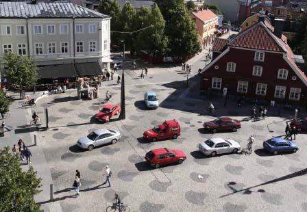
6 SKVALLER - TORGET SVERIGE


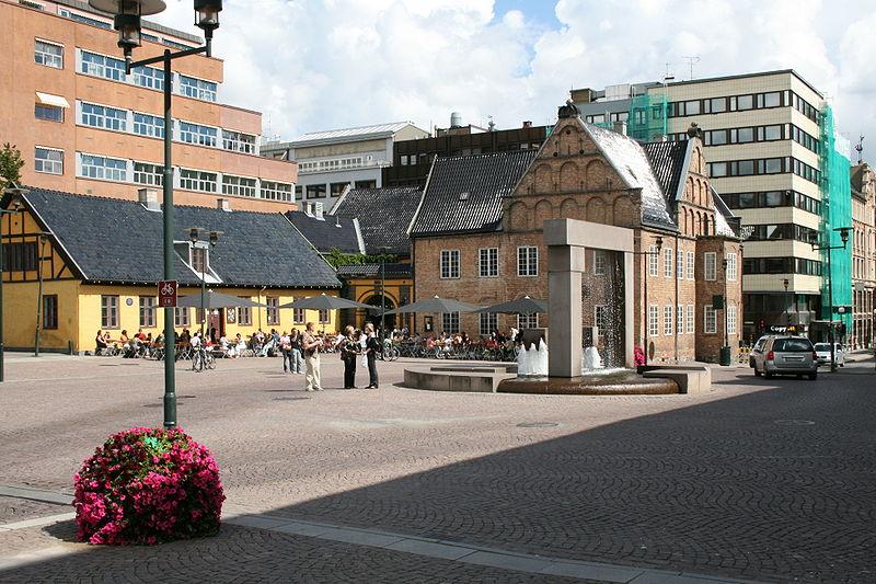
7 FISKARTORGET VÄSTERVIK SVERIGE


8 SOME DANISH EXAMPLES Skagen v/museet, Danmark Strædet, København sentrum Lyngby Hovedgade Odense v/domkirken, Danmark


9 Laweiplein, Drachten DIFFERENT EXAMPLES FROM THE NETHERLANDS Drachten Haren Oosterwolde Wolvega


10 SOME NORWEGIAN EXAMPLES Christiania torg i Oslo Asker Bekkestua St. Olavs plass i Oslo
11 FROM HOME ZONES IN RESIDENTIAL AREAS TO SHARED SPACE IN CITY CENTER Norske gatetun Danske sivegader Svenske gårdsgater Nederlandske woonerf Engelske home zones Shared space In residential streets with light and local traffic In the city center with more and different types of traffic


12 KEY EXPERIENCES + More appealing streets and more urban street life + Traffic accidents reduced because of low speed, interaction and eye contact - Insecurity - among specific groups of road users (visually impaired and elderly)
13 INSECURITY - the biggest challenge for Shared space! An environment that is easy to navigate in increases the sense of security Part of the Shared Space philosophy is based on creating insecurity in order to achieve safety!

14 WHY SOME FEEL INSECURE IN SHARED SPACE AREAS Unclear rules, no signs, no one has right on their side Traffic area without boundaries and guide lines People experience that the traffic volum is too high
15 HOW TO SOLVE THE PROBLEM OF INSECURITY IN SHARED SPACE? 1.Improve the projects for the elderly, blind and visually impaired 2.Adjust the projects by introduce the term: Shared space and safe space
 Select and secure pedestrian crossings - in the edge of the square - at regular intervals along the street Pedestrian crossing in the edge of Skvallertorget, with a smooth")
16 IMPROVEMENTS FOR THE BLIND AND VISUALLY IMPAIRED Improve the accessibility through proper use of materials and furnishings (contrast, guide lines, furnishing free zones...) Select and secure pedestrian crossings - in the edge of the square - at regular intervals along the street Pedestrian crossing in the edge of Skvallertorget, with a smooth surface and no curbs

17 SHARED SPACE AND SAFE SPACE


18 SHARED SPACE AND SAFE SPACE Shared space Shared space Safe space Shared space Safe space Safe space Shared space


19 SHARED SPACE AND SAFE SPACE Shared space Shared space Safe space


20 SHARED SPACE AND SAFE SPACE Shared space Safe space Safe space Shared space


21 USE MATERIALS BY FUNCTION From St. Olav's place - pedestrians using the smooth granite coating Wheelchair using the bike area with smooth surface The carriageway, with smooth surface, is used by pedestrians and cyclists


22 WHAT S THE LIMIT FOR TRAFFIC VOLUM? Thelowerthetrafficis, the better quality of stay in the street area


23 WHAT S THE LIMIT FOR TRAFFIC VOLUM? The lower traffic, the more people feel free to cross the area anywhere

24 WHAT S THE LIMIT FOR TRAFFIC VOLUM?
25 WHAT S THE LIMIT FOR TRAFFIC VOLUM? The more traffic, the more pedestrians there should be There should be a balance between cars and pedestrians


26 SKVALLERTORGET - A PLACE FOR ALL DESPITE HIGH LEVEL OF CAR TRAFFIC?????
27 RECOMMENDATIONS Choose the right places (based on a plan for the city center, a vision and anchoring, in the most populous streets/intersections/squares) Think quality and urban design Think activities and make it possible to stay in the street (shops, cafés, benches..) Do not front insecurity in the project Think both Shared and Safe Space Universal design must be ensured Let the function determine the use of materials Make low speed

28 The new international sign?? Shared space
Creating walkable, bikeable and transit-supportive communities in Halton
 Creating walkable, bikeable and transit-supportive communities in Halton By presenting current research and best practices, the information in this paper is meant to support and broaden discussion on how
The Right to Come Home: Shared Space, Woonerfs, and Safe Streets for All Road Users. Johan Diepens, CEO Mobycon
 The Right to Come Home: Shared Space, Woonerfs, and Safe Streets for All Road Users Johan Diepens, CEO Mobycon info sports 2015-10-07 4 From a Dutch perspective 5 MOBILITY Mobility; a condition for functioning
CARE AND VIGILANCE SAVE LIVES!
 CARE AND VIGILANCE SAVE LIVES! PEDESTRIAN, Be Safety Conscious! Each day, approximately ten pedestrians are involved in traffic accidents throughout Québec. If you use the province s road network on foot,
PRINCE GEORGE S PLAZA METRO AREA PEDESTRIAN PLAN
 PRINCE GEORGE S PLAZA METRO AREA PEDESTRIAN PLAN May 28, 2008 Agenda Welcome and introductions Project overview and issue identification Planning context and strengths Design challenges and initial recommendations
CIVITAS Peer to Peer Exercise in Reggio Emilia 11 November km zone: Reggio Emilia gets to know the experience of Odense and Vitoria-Gasteiz
 CIVITAS Peer to Peer Exercise in Reggio Emilia 11 November 2014 30 km zone: Reggio Emilia gets to know the experience of Odense and Vitoria-Gasteiz The City of Reggio Emilia Reggio Emilia is a medium sized
Agenda. Overview PRINCE GEORGE S PLAZA METRO AREA PEDESTRIAN PLAN
 PRINCE GEORGE S PLAZA METRO AREA PEDESTRIAN PLAN May 28, 2008 Agenda Welcome and introductions Project overview and issue identification Planning context and strengths Design challenges and initial recommendations
York Boulevard Streetscape Master Plan
 York Boulevard Streetscape Master Plan October 24 th, 2008 The Story of York Boulevard Streetscape Master Plan Design. Chapter 126 Dealing with Engineers. 2 1 Today s Presentation Topics: 1. Show the streetscape
WalkSafe Vocabulary Matching. 1 pedestrian A marked place to cross the street. 2 intersection A person who is walking. 3 crosswalk. 4 curb.
 WalkSafe Vocabulary Matching Name Directions: Draw a line from the vocabulary word to its definition. 1 pedestrian A marked place to cross the street. 2 intersection A person who is walking. 3 crosswalk
Potentials and problems arising from integration - A critical view on the safety effect
 Potentials and problems arising from integration - A critical view on the safety effect Michael W. J. Sørensen Senior Research Engineer, PhD Institute of Transport Economics Devils Advocate Seminar: Shared
Pedestrians safety. ROAD SAFETY SEMINAR PIARC/AGEPAR/GRSP Lome, Togo October 2006 Lise Fournier, Canada-Qu
 Pedestrians safety ROAD SAFETY SEMINAR Lome, Togo October 2006 Lise Fournier, Canada-Qu Québec Contents WHO s data Risk factors Pedestrian needs Pedestrian facilities Conclusion Source: WHO WHO reports
Pedestrians under high-risk despite technological improvements
 Pedestrians under high-risk despite technological improvements Protecting them with a new paradigm and the help of Vision Zero. In Argentina, 22% of deaths in traffic are pedestrians. In Buenos Aires City,
Pedestrian Safety Tips
 Pedestrian Safety Tips FACT: Pedestrian safety is the responsibility of BOTH the drivers on the road and the pedestrians. FACT: NO vehicle can Stop on a Dime. The average passenger vehicle traveling 40
Designing for Individuals who are visually impaired or blind
 Designing for Individuals who are visually impaired or blind Janet M. Barlow Accessible Design for the Blind NACTO Designing Cities Conference October 25, 2012 What do we mean by visually impaired or blind?
A CHANGING CITY. of Edmonton, it is essential that it reflects the long-term vision of the City.
 A CHANGING CITY By the year 2040, Edmonton will be home to more than 1 million people. To accommodate growth and support a healthy and compact city, we need a new approach to development/redevelopment
Use this guide to learn more about walkability and how you can make your community safer to walk
 Walkability Guide Do You Enjoy Walking In Your Community? Use this guide to learn more about walkability and how you can make your community safer to walk 2 About This Guide Circulate San Diego believes
LECTUR 10 CHARACTERISTICS OF THE DRIVER, THE PEDESTRIAN, THE VEHICLE AND THE ROAD. One problem that faces traffic and transportation engineers is:
 LECTUR 10 CHARACTERISTICS OF THE DRIVER, THE PEDESTRIAN, THE VEHICLE AND THE ROAD 3.1 DRIVER CHARACTERISTICS Physiological Measurable and Usually Quantifiable Psychological Much more difficult to measure
Putting Inverness Streets Ahead
 Putting Inverness Streets Ahead Who we are This leaflet has been produced by the Royal National Institute of Blind People (RNIB) Scotland in collaboration with: Access for All - Inverness Access Panel
Welcome. Welcome to the second open house on the Downtown Transportation Study.
 Welcome 1 Welcome to the second open house on the Downtown Transportation Study. The purpose of this meeting is to: Recap the study objectives Summarize feedback to date Present information on the alternatives
MEET IN THE STREET MOVING TO ZERO
 WE MEET IN THE STREET MOVING TO ZERO Tips for sharing the street Traffic deaths are preventable. We need your help getting the message out. 2 A NEW PLAN A NEW PLAN Philadelphia is proud to adopt Vision
Small Town & Rural Multimodal Networks
 Small Town & Rural Multimodal Networks Fred Young, PLA Andrea Clinkscales, AICP, PMP Alta Planning + Design Funding Partners Project Team Existing Design Guidance AASHTO Flexibility Guide 2004 AASHTO Bike
STEERING COMMITTEE MEETING June 17, Streetscape Overview Burlington Comprehensive Master Plan
 STEERING COMMITTEE MEETING June 17, 2015 Streetscape Overview Burlington Comprehensive Master Plan 1 Introduction Slide This slide show was presented to the Burlington Steering Committee on June 17, 2015
General Design Factors
 Chapter 3: 3-1.0 Introduction General Design Factors Mn/DOT s goals include encouraging and accommodating safe bicycling. From a design perspective, these goals are achieved by first having an understanding
Truck accidents. Rikke Rysgaard Danish Road Traffic Accident Investigation Board
 Truck accidents Rikke Rysgaard Danish Road Traffic Accident Investigation Board 1 Danish AIB Created in 2001 The purpose of AIB is to: Compile knowledge Raise awareness Make recommendations Encourage preventive
Shared Space and Naked Intersections
 2008 Municipal Engineering Foundation Victoria Overseas Study Tour Shared Space and Naked Intersections Prepared By: David Sutcliffe Director of Technical and Development Services Central Goldfields Shire
GIS Based Data Collection / Network Planning On a City Scale. Healthy Communities Active Transportation Workshop, Cleveland, Ohio May 10, 2011
 The Purpose of GIS Based Network Planning GIS Based Data Collection / Network Planning Healthy Communities Active Transportation Conference Tuesday, May 10, 2011 10:00 AM Norman Cox, LLA, ASLA. Ann Arbor,
TRAFFIC SAFETY LESSON
 ZERO TRAFFIC DEATHS BY 2030 PURPOSE TRAFFIC SAFETY LESSON The purpose of this lesson is to introduce students to the basic concepts of traffic safety and life lessons for using our streets, whether while
TORONTO VISION ZERO Improving Safety for Pedestrians and Cyclists Roger Browne, Manager Traffic Safety Unit October 11, 2018
 1 TORONTO VISION ZERO Improving Safety for Pedestrians and Cyclists Roger Browne, Manager Traffic Safety Unit October 11, 2018 2 AGENDA 1. Pedestrian Safety Countermeasures 2. Cyclist Safety Countermeasures
Emergencies in road tunnels Consideration of the needs of people with disabilities
 Emergencies in road tunnels Consideration of the needs of people with disabilities Dr. Regina Ernst & Dr. Dirk Boenke Rehabilitation International (RI) Road tunnels: Special conditions (1) traffic function
Green Streets and Urban Greenways
 127 11 Green Streets and Urban Greenways 11. Green Streets and Urban Greenways 128 11 Green Streets and Urban Greenways Once the traffic-free section of a route has come to an end, then comes the remaining
Unit Five : Driving In Neighborhoods
 Unit Five : Driving In Neighborhoods What Are We Going To Do Today? Students will be able to describe the skills necessary to How safely and do legally you make drive in a residential How do area. you
The Present State and Future Outlook of Taipei s Traffic
 The Present State and Future Outlook of Taipei s Traffic Anne CHUNG Commissioner of the Department of Transportation, Taipei City Government 1 Contents 1. Present traffic State in Taipei 2.The Challenges
BEST PRACTICES FOR ACCESSIBLE TRANSPORT. C G B (Kit) Mitchell
 Mitchell") BEST PRACTICES FOR ACCESSIBLE TRANSPORT by C G B (Kit) Mitchell Independent mobility is necessary for independent living Many people with disabilities use cars, either as driver or passenger Those who
BEST PRACTICES FOR ACCESSIBLE TRANSPORT by C G B (Kit) Mitchell Independent mobility is necessary for independent living Many people with disabilities use cars, either as driver or passenger Those who
Chapter 6: Along the Street
 Chapter 6: Along the Street This section describes the types of infrastructure that should be in place along school routes to make walking and bicycling to school safer. Sidewalks In communities with sidewalks,
The Commonwealth of Massachusetts Executive Office of Health and Human Services Commission for the Blind 48 Boylston Street, Boston, MA
 MASSACHUSETTS WHITE CANE LAW All motorists, when they see a pedestrian who uses a dog guide or a white cane at a street crossing, must come to a complete stop. Massachusetts General Laws Chapter 90 Section
City of Lima Bicycle Parking Guide
 City of Lima Bicycle Parking Guide The Allen County Bike and Pedestrian Task Force is a community organization that is Allen County s voice for safe places to walk, bike and be active in Allen County Keeping
Designing Pedestrian Facilities for Accessibility. Module 3 Curb Ramps & Blended Transitions
 Module 3 & Other Purpose: Allow pedestrians to transition between the street and sidewalks, islands, etc. Typically installed at: Intersections (1 ramp at each end of each crosswalk) Mid-block crossings
 Q-Series R-Series G-Series 150-GT 150-QT O-Series 150-OT 150-RT 100-GSF 100-QSF *Note: Additional designs and product drawings available on website The Queen-Style Bollard is a sophisticated yet time-honored
BETTER CONDITIONS TO ACHIEVE LOWER RISK FOR PEDESTRIANS IN THE INTERSECTION PLAZA ESPAÑA AV. REINA Mª CRISTINA IN BARCELONA
 BETTER CONDITIONS TO ACHIEVE LOWER RISK FOR PEDESTRIANS IN THE INTERSECTION PLAZA ESPAÑA AV. REINA Mª CRISTINA IN BARCELONA Intersecting safely (International Student Competition) Author: Jose Mª Ortiz
Economic and Social Council
 UNITED NATIONS E Economic and Social Council Distr. GENERAL 20 December 2006 ENGLISH Original: ENGLISH and FRENCH ECONOMIC COMMISSION FOR EUROPE INLAND TRANSPORT COMMITTEE Working Party on Road Traffic
Road safety Strategy and road safety Targets for Bulgaria
 Road safety Strategy Road safety Strategy and road safety Targets for Bulgaria Alan Ross Road crash fatality reduction targets Country Base-year for target Year in which target is to be realised Target
Appendix B. NOP Responses
 Appendix B NOP Responses file://p:\projects - All Employees\D50000+\51362.01 65th Street EIR\ADEIR\Appendices\... Page 1 of 1 8/12/2008 From: Fedolia Harris [FHarris@cityofsacramento.org] Sent: Monday,
Pedestrian Crossing Facilitation Guideline Development
 Pedestrian Crossing Facilitation Guideline Development TZD Conference Melissa Barnes October, 2017 Why? Minnesota Go: Minnesota s multimodal transportations system maximizes the health of people, the environment,
FUNDING OPTIONS FOR COMPLETE STREETS PROJECTS. Dean Ledbetter, PE Senior Planning Engineer NCDOT Division Eleven
 FUNDING OPTIONS FOR COMPLETE STREETS PROJECTS Dean Ledbetter, PE Senior Planning Engineer NCDOT Division Eleven DIVISION ELEVEN PRESENTATION OVERVIEW Sample Complete Streets Projects in Division Eleven
WATCH OUT FOR PEDESTRIANS!
 Meeting Leader: SAFETY MEETING PLANNER & AGENDA WATCH OUT FOR PEDESTRIANS! Prepare in advance to make this meeting effective. Go to the Thinking Driver website for instructions on how to best use this
Pedestrian Safety at Roundabouts
 Countermeasure Strategies for Pedestrian Safety Pedestrian Safety at Roundabouts Hillary Isebrands Federal Highway Administration January 6, 2016 Today s Presentation Introduction and housekeeping Audio
Roundabout Design Principles
 des Carrefours Giratoires Roundabout Design Principles NCLUG Roundabout Luncheon Tuesday, March 4, 2014 Prepared by: des Carrefours Agenda Giratoires Roundabout design process: Planning and Policy Lane
Healthy Corridor Audit Tool
 Healthy Corridor Audit Tool How to Use:»» Complete the first section for the entire study area. Many indicators can be collected from existing data; they do not have to be collected on site.»» To assess
4 GENERIC COST ESTIMATING TOOL
 4 GENERIC COST ESTIMATING TOOL Table 4-1 presents a generic cost estimating tools that can serve as a conceptual planning tool for local jurisdictions to estimate the costs of pedestrian improvements.
ADA on Construction. Guidance for Section C Plan Preparers
 ADA on Construction Guidance for Section C Plan Preparers Some impacts cannot be avoided and those impacts apply to residents, businesses, motorists, and pedestrians alike. However, good planning can minimize
SUMP of Ravenna: relevant experiences on travel behavior change
 SUMP of Ravenna: relevant experiences on travel behavior change Nicola Scanferla, Head of Mobility Planning Unit Giorgia Rambaldi, Mobility Planning Unit nscanferla@comune.ra.it giorgiarambaldi@comune.ravenna.it
Accommodating Pedestrians in the Work Zone
 Accommodating Pedestrians in the Work Zone Guidance for Section C Plan Preparers Some impacts cannot be avoided and those impacts apply to residents, businesses, motorists, and pedestrians alike. However,
TRAFFIC CALMING TOOLBOX. For the residents of the City of Decatur, Georgia
 TRAFFIC CALMING TOOLBOX For the residents of the City of Decatur, Georgia 2 City of Decatur Traffic Calming Toolbox Public Works Department 2635 Talley Street Decatur, GA 30030 404.377.5571 3 Welcome to
Bicycles and Pedestrians on ISU Campus. Indiana State University Police
 Bicycles and Pedestrians on ISU Campus Indiana State University Police FASTEST Transportation On Campus There has been an increase in cyclists and pedestrians on campus as student enrollment continues
good walking is good business making massachusetts more walkable
 good walking is good business making massachusetts more walkable Nothing draws a crowd like a crowd. P.T. Barnum 15 minutes with WalkBoston who we are / what we do why walkability makes economic sense
SIGNALIZED T-INTERSECTION SAFETY REVIEW
 SIGNALIZED T-INTERSECTION SAFETY REVIEW Mark Halpin, Transportation Planner, City of Port Moody Sean O Sullivan, Traffic Operations Engineer, City of Coquitlam Matthew Chan, Traffic Engineer, Parsons Project
complete streets design and construction standards public primer City of Edmonton
 complete streets design and construction standards public primer City of Edmonton introduction Complete Streets are streets for everyone: people who walk, wheel, bike, take transit, or drive. They are
Ballston Station Multimodal Study WMATA and Arlington County. Meeting Minutes
 Date of Meeting: June 10, 2010 Location: Ballston Metrorail Station and NRECA Building 4301 Wilson Blvd, Arlington, VA Subject: Ballston Station Multimodal Study Stakeholder Meeting #1 Summary: This first
RUE DE L AVENIR FRANCE TRAFFIC CALMING IN FRANCE. MAKING CITIES WALKABLE: the French case RUE DE L AVENIR FRANCE
 ICTCT WORKSHOP OLOMOUC 26-27/10/2017 ANNE FAURE, Created in 1988 after a context of cities dominated by car objective of 70s to adapt the cities to cars but to protect vulnerable users? The 80s : new way
Bicyclists and Truck Driver Visibility
 Bicyclists and Truck Driver Visibility Posting Date: 08-Aug 2014 On August 7th, 2014 a 19-year-old female cyclist was killed when her bicycle was run over by a concrete mixer truck at the intersection
MARTIN LUTHER KING JR. WAY
 OCTOBER 2011 40 Vision and Goals The Martin Luther King, Jr. Way Illustrative Master Plan that follows has been developed through a process of community involvement. It expresses a long term vision for
Prisma Daps DIGITAL ACOUSTIC PEDESTRIAN SIGNAL
 DIGITAL ACOUSTIC PEDESTRIAN SIGNAL 2000 Vietnam ONE OF THE BEST LOCATION SOUNDS Effective sound without being louder Audible through all ambient traffic noise Easy to locate the source of the sound Not
THE OFFICIAL GUIDE TO CYCLING SAFELY IN PHILADELPHIA
 B IKE NICE THE OFFICIAL GUIDE TO CYCLING SAFELY IN PHILADELPHIA A partnership of the City of Philadelphia and the Bicycle Coalition of Greater Philadelphia ABOUT VISION ZERO & BIKE NICE It s a great day
Shared Court Housing Concept Summary
 January 20, 2006 Shared Court Housing Concept Summary Zoning Code Definition (adopted 12/21/05) Shared Court. A street that is designed to accommodate within the same circulation space access for vehicles,
Bicycle Facilities Planning
 Bicycle Facilities Planning Overview Types of Cyclists Purpose for Riding Types of Facilities Bike Lanes Bicycle Boulevards Cycle Tracks Intersections Signals Signing and Marking Discussion Types of Bicyclists
WELCOME Public Information Centre
 WELCOME Public Information Centre Fernforest Drive Brampton Soccer Centre Community Room #2 Tuesday January 19, 2016 6:30 p.m.to 9:00 p.m. Please sign in Neighbourhood Traffic Calming Guide Background
Hennepin County Pedestrian Plan Public Comment Report
 Hennepin County Pedestrian Plan Public Comment Report On May 31, 2013, the draft Hennepin County Pedestrian Plan was released for a 45-day public comment period ending July 15, 2013. The county received
DIGITAL ACOUSTIC PEDESTRIAN SIGNAL 2000 TS-9XX
 DIGITAL ACOUSTIC PEDESTRIAN SIGNAL 2000 TS-9XX Vietnam ONE OF THE BEST LOCATION SOUNDS Effective sound without being louder Audible through all ambient traffic noise Easy to locate the source of the sound
Safe Routes to School Grant Application Phase I March 2014
 Safe Routes to School Grant Application Phase I March 2014 Page 1 The City of Mission is requesting grant funding to create a Safe Routes to School Plan which will encompass all of the existing elementary
Construction Newsletter No. 32 October 14, 2016 On-Going
 Construction Newsletter No. 32 October 14, 2016 On-Going Here s a block-by-block breakdown of the work currently underway: Harvey Street to Clegg Street: Placement of green thermoplastic for the cycle
Report on MEPS Přerov TH MIDDLE EUROPEAN PROJECT SEMINAR LAURA ENJUANES NOGUERO E
 2017 Report on MEPS Přerov 2017 28TH MIDDLE EUROPEAN PROJECT SEMINAR LAURA ENJUANES NOGUERO E01650478 Table of Content 1. Introduction... 1 2. Problem definition... 1 3. Proposed solution in the presentation...
Impact assessments of cycle schemes
 Impact assessments of cycle schemes Anne Kjerkreit, Norwegian Public Roads Administration anne.kjerkreit@vegvesen.no Agenda Introduction Impact assessments in Norway CBA of cycle schemes Challenges and
Re-Engineering Transport Designs for Safe and Universal Accessibility. Dr. Sewa Ram School of Planning and Architecture New Delhi
 Re-Engineering Transport Designs for Safe and Universal Accessibility Dr. Sewa Ram School of Planning and Architecture New Delhi Approach towards safe mobility What is Accessibility? Access +Ability Measuring
Walkability in St Kilda Creates a Feeling of Social Cohesion Lily Weinberg Healthy Communities Assignment 2 14 September 2009
 Walkability in St Kilda Creates a Feeling of Social Cohesion Lily Weinberg 260504 Healthy Communities Assignment 2 14 September 2009 Introduction I used the Walkability Checklist to evaluate the walkability
Public Information Centre
 WELCOME Public Information Centre Father Tobin Road Lougheed Middle School - Library Wednesday November 7, 2012 7:00 p.m.to 9:00 p.m. Please sign in Neighbourhood Traffic Calming Guide Background The City
Supporting Safer Cities. ENHANCING LAST MILE CONNECTIVITY a safety analysis of the Mandi House Metro Station
 Supporting Safer Cities ENHANCING LAST MILE CONNECTIVITY a safety analysis of the Mandi House Metro Station This Report has been prepared as part of the Project being undertaken with NDMC to Enhance the
Pedestrian crossings survey in Europe
 Pedestrian crossings survey in Europe Introduction The issue of accidents on pedestrian crossings is highly emotional and raises a very strong interest within the public opinion and the media, mainly because
5. PLASTIRA STREET Case Study Area and Character Sections. Marina. Case Study Area. Character Sections. National Report of Greece
 Plastira 5. PLASTIRA STREET 5.1. Case Study Area and Character Sections Case Study Area Plastira street is located in the Eastern part of the city of Kalamaria and it is a significant two-way arterial
CITY OF VAUGHAN EXTRACT FROM COUNCIL MEETING MINUTES OF OCTOBER 30, 2012
 CITY OF VAUGHAN EXTRACT FROM COUNCIL MEETING MINUTES OF OCTOBER 30, 2012 Item 31, Report No. 39, of the Committee of the Whole, which was adopted without amendment by the Council of the City of Vaughan
Toronto Complete Streets Guidelines
 88 90 5.1 Cycling Design Principles 92 5.2 Context-sensitive Cycling Facilities 96 5.3 Key Cycling Elements Cycling infrastructure provides choice in how people are able to move around the city. Cyclists
THE PHILADELPHIA COMPLETE. an overview
 THE PHILADELPHIA COMPLETE STREETS DESIGN HANDBOOK an overview WHAT ARE COMPLETE STREETS? Complete Streets are streets designed to accommodate all users, from pedestrians to drivers Complete Streets provide
PEDESTRIAN ACCOMMODATIONS DPS 201 AT ROUNDABOUTS
 PEDESTRIAN ACCOMMODATIONS DPS 201 AT ROUNDABOUTS WHY THEY WORK FOR PEDESTRIANS IF DESIGNED CORRECTLY Separated sidewalks direct peds to crosswalks Splitter island Slow speed exit Truck apron Crosswalk
Complete Streets for Niagara A working method to visualize the creation of a complete street June 20th, 2013
 Complete Streets for Niagara A working method to visualize the creation of a complete street June 20th, 2013 C O N T E N T S Introduction and background of the report What is a complete street? What can
Footpath design. A guide to creating footpaths that are safe, comfortable, and easy to use
 Footpath design A guide to creating footpaths that are safe, comfortable, and easy to use November 2013 Contents Introduction / 1 Zoning system / 2 Width / 4 Height / 5 Surface / 5 Footpath elements /
Cities for People video by Prof Jan Gehl
 Public Spaces as a Critical Policy Element Cities for People video by Prof Jan Gehl ( Life between Buildings ) Mikel Murga Fall 2006 Point of departure In a world being steadily privatized, in some cities
Position Paper on Accessible Roundabouts
 Position Paper on Accessible Roundabouts June 2012 This research based document outlines essential elements in the design of roundabouts, to make them accessible for all pedestrians, including those who
summary of issues and opportunities
 1 summary of issues and opportunities EXECUTIVE SUMMARY CHAPTER 2: HISTORY - 3: LAND USE This first chapter is an overview of lessons learned from analysis of the existing conditions on El Camino as well
BYRES ROAD: PUBLIC REALM Public Consultation
 Public Consultation Introduction As a vibrant commercial, shopping and residential location within the heart of the West End Byres Road is an important destination. Its proximity to the University of Glasgow
Utility vehicle safety. Operator training program
 Utility vehicle safety Operator training program Permissible use Utility Vehicles may only be operated only as follows: To transport people, equipment or supplies When operated by an eligible Utility Vehicle
Cycling and risk. Cycle facilities and risk management
 Cycling and risk Cycle facilities and risk management Failure to recognize possibilities is the most dangerous and common mistake one can make. Mae Jemison, astronaut 6/11/2010 York Regional Council Cycling
Safety and Active Transport. Dr. Maureen Carew, Medical Officer of Health Renfrew County and District Health Unit May 30, 2014
 Safety and Active Transport Dr. Maureen Carew, Medical Officer of Health Renfrew County and District Health Unit May 30, 2014 Active Transport Vision Increase levels of walking and cycling Reduce vehicle
OLDER PEOPLE INDEPENDENT MOBILITY FOR LIVEABLE COMMUNITIES. Christopher G B (Kit) Mitchell
 Mitchell") OLDER PEOPLE INDEPENDENT MOBILITY FOR LIVEABLE COMMUNITIES by Christopher G B (Kit) Mitchell Independent mobility is necessary for a high quality of adult life In developed countries, the automobile has
OLDER PEOPLE INDEPENDENT MOBILITY FOR LIVEABLE COMMUNITIES by Christopher G B (Kit) Mitchell Independent mobility is necessary for a high quality of adult life In developed countries, the automobile has
MCIWEST-MCB CAMP PENDLETON Critical Days of Summer Newsletter. Week 11: 31 Jul - 04 Aug Bicycle Safety
 Bicycle Safety ride in the street, obey all traffic signs, signals, and lane markings. Bicycle riding is a healthy, fun way to be independent and basic safety concepts can help you make the most of your
Submission on Clontarf to City Centre Cycle Route with signatures of 1,493 people
 Submission on Clontarf to City Centre Cycle Route with signatures of 1,493 people Route should use a fully segregated two-way cycle path Contact details Cian Ginty - editor, IrishCycle.com - cian.ginty@gmail.com
A. Pedestrian Facility Design
 A. Pedestrian Facility Design Photo by Dan Burden Photo by Cara Seiderman Walkways are the portion of the public right-of-way that provide a separated area for people traveling on foot.walkways that are
The Wiggle Route in Context
 The Wiggle Route in Context In a city of hills, the Wiggle is an important route because it winds its way along the flattest streets from Market to the Panhandle, bringing residents to local parks and
TRANSPORTATION STANDARDS
 INTRODUCTION LOCAL STREETS ON-STREET PARKING SIDEWALKS STREET LIGHTING STREET FURNISHINGS TRAFFIC CALMING STREET TREES MEDIAN PLANTING BOULEVARD LOCATIONS VILLAGE CENTER STREET LOCATIONS RESIDENTIAL STREET
LEA BRIDGE ROAD - A STREET FOR EVERYONE Public consultation document
 LEA BRIDGE ROAD - A STREET FOR EVERYONE Public consultation document TELL US Bakers Arms to Leyton Green Road (Section D, E, F) Leyton Green Road to Whipps Cross Roundabout (Section G) YOUR VIEWS www.enjoywalthamforest.co.uk
Commerce Street Complete Street Project from Good Latimer Expressway to Exposition Avenue
 Commerce Street Complete Street Project from Good Latimer Expressway to Exposition Avenue T A N Y A B R O O K S A S S I S T A N T D I R E C T O R M O B I L I T Y P L A N N I N G M O B I L I T Y A N D S
01. VICINITY OF GREENBRAE POC: EXISTING CONDITIONS
 01. VICINITY OF GREENBRAE POC: EXISTING CONDITIONS Existing Bus Stop Existing US101 On-ramp Existing POC Old Redwood Highway Rich Street City ROW Environmental Study Limit Industrial Way NO DESIGNATED
Pedestrian overcrowding and emotions in Thessaloniki, Greece
 Pedestrian overcrowding and emotions in Thessaloniki, Greece Eva Papakonstanti & Ioanna Tsakalakidou (Urban & spatial planners) The background of Thessaloniki Thessaloniki is the second largest city of