Charlottesville - Albemarle Rescue Squad
|
|
|
- Reynard Robbins
- 5 years ago
- Views:
Transcription
1 Charlottesville - Albemarle Rescue Squad Map Orientation 2007 By Dayton Haugh, Chief Updated
2 Objectives Learn service performance expectations Learn what maps we carry Learn local numbering schemes Learn how to use the maps we carry Learn how to use the STREET data base book Learn certain known problem areas
3 How to use this presentation There is a handout book that reproduces all slides - some maps may be easier to read in the handout The presentation is best viewed as a slide show Under slide show click view show To advance to the next slide push the space bar or page down key If you want to go back, push the page up key
4 Service Expectations In any progressive EMS system there are certain expectations that must be met to insure quality service: the service must be timely the service must be efficient and costeffective the service must be medically appropriate
5 Timely In a high performance urban system the time period between the time the location, chief complaint and call back number are obtained, and the time the ambulance arrives on scene should be 8 minutes or less 90% of the time We cannot affect the time it takes to process the call in the center, but it eats away at the 8 minutes
6 Timely We can affect the time it takes us to begin responding once notified less than 2 minutes after bedtime less than 1 minute all other times We can make sure we take the most expeditious route
7 Efficient An efficient response means that you: know where to go take the best route to get there arrive alive, ready to promptly provide care you must decide who will take what equipment before you arrive, so you don t fumble around for 5 minutes getting stuff once you have arrived
8 Efficiency Some signs of inefficiency include asking for a cross-street when you really want someone to tell you where the street is (and you don t really know what a crossstreet is, but you heard it on Emergency!) asking for the location of things that you can see better in the map book if you only were to look
9 Efficiency An efficient response begins when the call is dispatched when you hear dispatch tones, STOP TALKING and listen, even if it is not our call - it may become our call if it is our call promptly get in the truck and sign on responding to the address confirm the information on the pager if you don t have the page yet, ask ECC for the call information find the route
10 Efficiency DO NOT cross the bridge until you know where you are going If you are riding up front, you are the navigator You are also responsible for making sure the driver can navigate back out before you leave the scene
11 After you have reviewed this material, the best way for you to actually learn your way around is to go buy an ADC map book go out and ride around
12 Maps You Will Use In each truck you should find: A big dark blue E-911 map book prepared by Albemarle County A spiral bound STREET data base A spiral bound Subdivision data base An ADC map book A U.Va. Grounds map Each has it s advantages and disadvantages
13 Maps The E-911 map book is big and has small print, but is very detailed splits some subdivisions over many pages, sometimes not next to each other allows you to pinpoint the actual location of a particular structure address in the county best used when you are going out in the county and have some time to look it up
14 Maps The STREET data base has directions to most streets in our first due area from the squad building (some from UVA & R8) uses some routes that are unfamiliar but faster doesn t tell you how to get back to the hospitals requires attention to block numbers to insure you go to the right part of the right street was prepared by me, John Kheir and Alice Armstrong by going through the E-911 book, finding our streets, and preparing directions for each street - that means occasionally it is wrong
15 Maps Subdivision data base gives detailed directions and maps for major subdivisions the STREET book will give you a few turns and refer you to the Subdivision book the STREET book will no longer have the subdivision maps because they take up too much room
16 Maps The ADC map book is easier to use than the E-911 map book doesn t accurately show block numbers is sometimes hard to read in congested areas does include U.Va. Is a good double check for directions in the STREET book or to form some impression of the distance between turns indicated in the STREET book
17 Maps The U.Va. Grounds map is prepared by U.Va. is great for finding a particular building is frequently missing there is a U.Va. Section to the ADC book also
18 Maps FIRST check the STREET book because it tells you which way to turn from the building some streets can be reached from more than one direction the STREET book will give you the quickest route
19 Maps Then, you can check another map the ADC for a quick check of the location the ADC page and grid are listed in the STREET book the E-911 book if you want to find a specific structure location in the county the Subdivision book for some subdivisions the STREET book will also give you a reference if a street can be found in the subdivision book
20 General Map Information To use a map you need to know: where you are and where you want to be that most commercial maps (ADC and E911) have North at the top, but the subdivision maps do not have any particular orientation
21 Where You Are I presume you know you are in Charlottesville I do not presume that you can find Charlottesville on a map I do not presume that you know Charlottesville s location with regard to other counties or cities So, let s look at our general location...
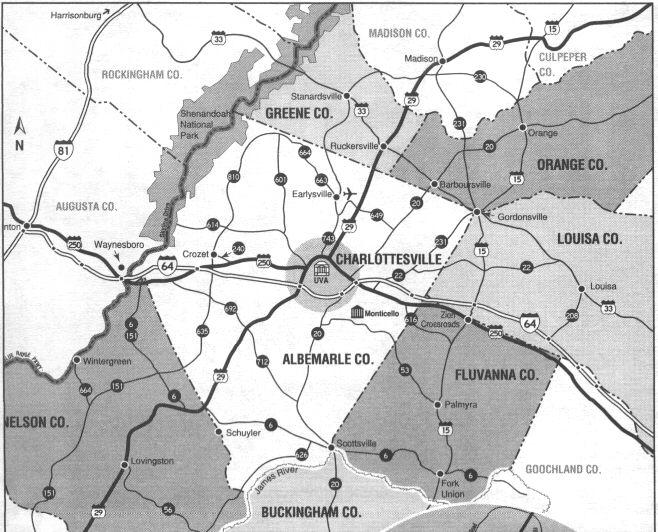
22
23 Where You Are Were you slick enough to see the little arrow pointing up on the left side of the map? (page up to look again) That is the North arrow All commercial maps have a North arrow (the tip points to the North) If you go in the direction of the arrow, you are going North
24 Where You Are When somebody here gives you a reference, like Rt. 250 East, they mean starting from Charlottesville - the part of Rt. 250 that is situated East of Charlottesville (see next slide)
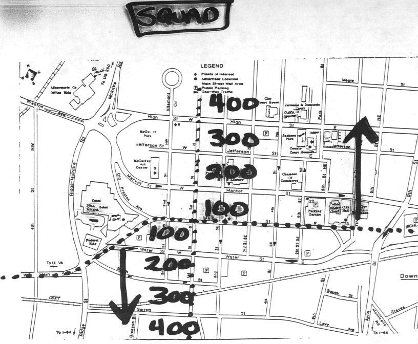
25
26 Where You Are When someone here tells you Rt. 20 North, they mean Rt. 20 North of Charlottesville BUT, when someone tells someone in Scottsville Rt. 20 North, they mean Rt. 20 North of Scottsville, which would be Rt. 20 South for us (see next slide)

27
28 Where You Are Did you notice that Scottsville has a Rt. 20 South also? Remember that if we go to help Scottsville and we expect to meet on Rt. 20, we will be going South on Rt. 20 South, and they will be going North on what is Rt. 20 North for them (they mostly say Rt. 20 South when they talk to us so we won t get confused; they know where they are!)
29 Where You Are It s all determined by your initial reference point Your initial reference point is Charlottesville
30 Where You Want To Be Unless you are going to the intersection of X Street and Y Street, you will probably be going to a street address (like 123 Main Street) Wouldn t you like to know how it got to be 123 on Main Street (I presume you already know somebody named it Main Street)?
31 Where You Want To Be Well, there are some rules in numbering that can help you in finding out where to go Even numbers in the city are on the South and East sides of the street These rules are different for the city and county - the city started street naming and numbering long ago, the county just recently began a uniform system with the E-911 project
32 Where You Want To Be The city has a ground zero for the block numbering and also the numbered streets (like S. 1st St.) The block numbers get bigger as you get away from ground zero The numbered streets get higher numbers as you get away from ground zero Where is this ground zero?
33 Where You Want To Be Ground Zero is at 1st Street and Main Street 1st and Main is on the Downtown Mall (but it used to be a real street) This intersection marks the center of the city s 4 quadrants (NE, NW, SE & SW) (see next slide)

34
35 Where You Want To Be Main St. divides North and South There is an East Main St. and a West Main St. First St. divides East and West There is a South 1st St. and a North 1st St.
36 Where You Want To Be You may have noticed the box with Squad written in it This is at the top of the map That means the squad is North of the mall To get to Ground Zero you must go South and East
37 Where You Want To Be As you go further away from Main Street, the block numbers increase The first block off of Main St. on any intersecting street is the 100 block The next block is the 200 block The next block is the 300 block
38
39 Where You Want To Be The same thing happens to the block numbers as you move East or West from 1st St. In addition, at least for 18 or 19 streets, the streets are numbered! So the next street West is 2nd Street (and it is 2nd St. NW or SW depending on which side of Main St. it is on!)

40

41
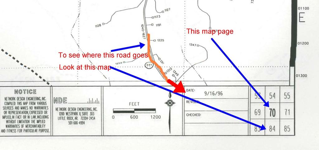
42 Where You Want To Be So you know that 105 West Main St. is just West of 1st. St. on the Downtown Mall The same is generally true of other streets parallel to Main St.: Market St., Jefferson St, Water St., High St., Preston Ave., etc. So, when you are dispatched to 1014 E. Market St., what is the cross-street? Hint: the cross-street is the intersecting street you cross before you enter the block the address is on!
43 Where You Want To Be If you answered 10th Street, NE you are doing well
44 Where You Want To Be A couple last thoughts about numbered streets While lots of them intersect Main St., not all do; you know that 15th St. NW and 17th St. NW do not intersect W. Main St. Many numbered streets start and stop here and there, even if they do intersect Main St /2 St. NW, for example The block number will help you estimate how far from Main St. your address is
45 Where You Want To Be What about addresses in the county? Generally, the farther you get from town, the higher the block number But, there are no good rules to help you You can locate the actual structure location by using the E-911 Map Book
46 Where You Want To Be To find the exact location of a county street, you must look in the index Almost each street has more than one entry, and it is depending on the block number you are looking for You will get a map reference, and you go to that map to see where the structure is
47 Where You Want To Be So lets say you want to go to George Dean Dr. You look in the index. and
48
49 you see under the Map # heading 76A The 76 is the county real property tax map number, and 76A is the E-911 map book page The county map layout is on the next slide See if you can find which section is 76

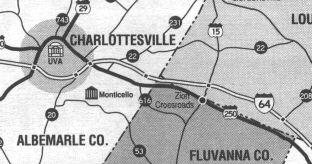
50
51 You can tell which map you are looking at by looking at the bottom right side of the map page, where you will see a grid showing the map and the other maps to each side of the map
52
53 The Grid heading for George Dean Dr. is E-2 this helps you find where on map 76A the street is The high and low heading tells you the street number range The Route number is the state route number (if any)
54 Lets look at the part with George Dean Dr. (next slide)
55
56 Where You Want To Be Could you find it? You can see that it is off Fontaine Avenue just past the intersection with the 29/250 By-Pass It happens to be the home of the Virginia Division of Forestry So, how do you know how to get from where you are to where you want to be with maps like that?
57 Some map areas are so congested that they rate a separate map page these areas are outlined on the main map (see next slide)

58
59 How To Get There There ARE certain streets/roads that you do need to be familiar with The first line county roads are shown in the next slide Rt. 29 North (Seminole Trail) Rt. 29 South (Monacan Trail Rd.) Rt. 250 East (Richmond Rd.) Rt. 250 West (Ivy Rd.)
60
61 How to get there There are also some other important roads shown in the next slide Rt. 20 N (Stony Point Rd.) and S (Scottsville Rd.) Rt. 22 (Louisa Rd.) Rt. 231 (Gordonsville Rd.) Rt. 53 (Thomas Jefferson Pkwy.) Rt. 795 (James Monroe Pkwy.) Rt. 601 (Free Union Rd.) Rt. 743 (Hydraulic Rd., Earlysville Rd., Advance Mills Rd.) Rt. 676 (Woodlands Rd.)
62
63 How to get there To help you get there, MOST streets in our first due area have printed directions from the building in the STREET data base book Let s look at George Dean Dr. again The next slide shows what you would see in the STREET book
64
65 Pretty slick, huh? There are several pieces to each entry Street name (and Rt. Number if there is one) Block : the numbers that this particular set of directions covers ADC : ADC Map Book page and grid Subdivision Map Book Page, if there is one, at end of directions The block field is important to be sure you go to the right place (see next slide)
66
67
68 As you might have noticed, if you weren t careful, you could easily wind up in the wrong place if you don t look for the correct street and block Some streets have block number entries in the directions themselves (see next slide)
69
70 You might also have noticed that some street names are in ALL CAPS, and some are have normal capitalization The streets in ALL CAPS are located in the City of Charlottesville The streets in normal type are located in Albemarle County Schools and nursing homes are also listed
71
72 As you might have noticed, the STREET directions give you a series of turns to make The first decision you must make is which way to turn out of our driveway (all directions are from the squad building) Your options are: LT McIntire Rd. (The LT is LEFT TURN) LT (West) By-pass RT (East) By-Pass (The RT is RIGHT TURN)
73 From the first turn there are many other options before you hopefully end up at the desired location Let s look at one poor hand-drawing of a set of options from the RT (East) By- Pass turn
74
75 That drawing shows some of the main turns One caution - the turn onto Meade Avenue off High Street is a frequently given turn - but you won t see a street sign for Meade Avenue where you can read it
76 In the front of the STREET book you will find 3 similar drawings, one for each initial turn option
77 One other thing that sometimes happens to you is a dispatch to Rt. 29 South (or Monacan Trail Rd.) in the vicinity of Gleco Mills for a motor vehicle accident Do you know where Gleco Mills is? It s a frequently used milestone but it has been closed for 20+ years So, we also need a milestone list that gives you at least an idea of what you will pass on your ride
78 Such a list will be in the front of the STREET book, and may have some distances also The milestone list would show Gleco Mills as being 9.5 miles from the squad on the left (about 3.4 miles past the I-64 bridge) The list is important in helping you use the directions that you are given by people who are very familiar with the area
79 One last thing about the STREET book - the numbered streets are now in the index listings!
80 Problem Areas - Illogical Addresses There are 800+ illogical addresses in the city alone that could mean that it has an even number which would ordinarily be seen on the East or South side of the street, and it is actually on the West side of the street it also could mean that the house numbers are out of order on that street or, it could mean that the 200 block is found where the 900 block should be, like the 200 block of Palatine Ave. (see next slide)
81
82 The STREET Book can help you find specific apartments, etc., in select subdivisions Always look in the index to see if there is a map that can help you in your search and quicken your response
83 But what about the illogical addresses? The known major problems, like the 200 block of Palatine, are mentioned in the STREET book But, illogical addresses aren t the only problem - there are many similar addresses or place names to confuse you Sometimes the street name is the same, but the numbers will help you sort it out
84 Problem Areas - Places That Sound the Same Lots of places or streets have the same or similar names Ednam, Ednam (Professional) Center, Ednam Forest, and Ednam Village Street are all different, but in the same general area off Rt. 250 West FOR EASILY CONFUSED STREET NAMES, BLOCK RANGES, ETC., THE BACKGROUND OF THE STREET BOOK IS SHADED. BE CAREFUL!

85
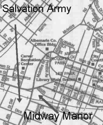
86 Problem Areas - Places That Sound the Same Farmington and Farmington Heights are adjoining, but you can t get from one to the other without a gate card! Farmington - enter off Rt. 250 West Farmington Heights - enter off Old Garth Rd. Rt. 601 (21 Curves)

87
88 Problem Areas - Places That Sound the Same 500 South 1st St. (Crescent Hall) and 511 North 1st St. (Charlottesville Towers) are both apartment complexes, but they are often confused for one another 500 South 1st is off Monticello Avenue 511 North 1st is off High Street

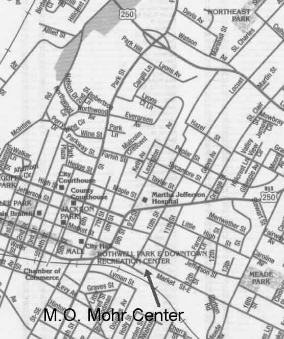
89
90 Problem Areas - Places That Sound the Same Monticello Avenue, Monticello Road and Monticello Loop are different, but close Monticello Avenue begins at Ridge Street across from the Fire Dept. and goes out to Piedmont Community College Monticello Road begins behind Spudnuts off Avon Street (but its one-way and you can t enter there) and winds down to Moore s Creek, which you can see on the left going down Monticello Avenue near Quarry Road
91 Problem Areas - Places That Sound the Same Monticello Loop is Monticello, the home of Thomas Jefferson, off Rt. 53, Thomas Jefferson Parkway Rt. 53 runs off Monticello Avenue/Rt. 20 S. just past the Piedmont Community College light (the next slide is slow to load)

92
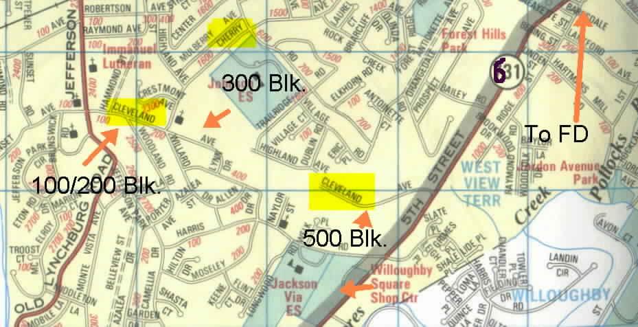
93 Problem Areas 100 Ridge Street (Midway Manor) entrance is off of South Street at the West Main light turn left onto South Street turn right into parking lot the FD has a key to get into the building and the apartments there if you need it
94 Problem Areas 207 Ridge Street (Salvation Army) you do not enter through the Ridge Street entrance you go around back go past the Salvation Army 1st RT on Dice Street 1st RT on 4th Street go to end of street and turn right into lot
95
96 Problem Areas 1014 East Market Street (M.O. Mohr Center) the quickest way to get there is: RT By-pass Exit Locust Avenue RT Locust go through stop light at MJH at Market St. light, left on Market St. Mohr Center is on the right (big yellow house) this is a substance abuse center so you may get called for people so intoxicated they need evaluation in the ED
97
98 Problem Areas 1400 Monticello Road Apartments and 1600 Monticello Avenue Apartments The E-911 CAD display for some 1400 Monticello ROAD addresses displays Monticello AVENUE, which is wrong - there are no apartments in the 1400 block of Monticello Avenue

99
100 Problem Areas Meade Avenue is a major route cited in the STREET book There is now a stop light and street sign It is the first left on East High Street off the By-pass

101
102 Problem Areas Greenbrier Drive has several sections in the city and county it intersects Seminole Trail (Rt. 29 N) in the county the 300 block is to the left (west) of Rt. 29 the 400 block is to the right (east) of Rt. 29 it runs between Brandywine Dr. and Rio Rd. in the city

103
104 Problem Areas Rock Creek Road has two sections the 600 to 700 block off of Cherry Avenue the 900 block off of Prospect Avenue

105
106 Problem Areas Old Lynchburg Road has several areas blocks off Jefferson Park Ave. reached by taking 5th St., RT on Harris Rd blocks off 5th St. Extd. Past I blocks by going straight out 5th St. Extended - turns into Old Lynchburg Rd. where the blocks intersect to the right

107
108 Problem Areas There are houses that carry a 250 By- Pass address these houses were there before the Bypass they are reached by taking one of the ramps for Park Street Look under 250 By-pass for maps of these houses
109 Problem Areas As you go past Locust Ave. the By-pass turns into Long Street there are houses with a long street address that are actually on the ramp from Locust Avenue to go East on Long Street

110
111 Problem Areas St. Clair Avenue is divided by Long Street up through the 800 block is South of the By-pass from 900 block up is North of the By-pass access to both is only from the Locust ramps the 1100 block (St. Clair Extd.) is off River Road

112
113 Problem Areas The By-pass splits many streets For most streets East the numbering is: up through 800 block South of the By-pass North of the By-pass remember - the squad is 828 McIntire Rd.
114 Problem Areas This numbering trick works for: Park Street St. Charles Avenue Locust Avenue St. Clair Avenue
115 Problem Areas Many people will give directions from a place or thing the Rock Store is located at the intersection of Hydraulic Road and Earlysville Road the twin bridges go over the reservoir the big bridge is Earlysville Rd. (Rt. 743) the little bridge is Woodlands Rd. (Rt. 676)

116
117 Chestnut Grove Baptist Church is a frequently used landmark mostly people say turn at Chestnut Grove Church or go straight at Chestnut Grove Church the church is up past Earlysville on Buck Mountain Road

118
119 There are several Rt. 29 South (Monacan Trail Rd.) milestones or landmarks Hickory Hill Store is just past I-64 Gleco Mills is an old mill located off Rt. 29 South Red Hill is at the intersection of Rt. 708 the crossroads is at Rt. 692 at North Garden Toco Hill and Cauls Grocery the old cold storage is at Covesville

120
121 Conclusion I hope this has been helpful in giving you basic information I encourage you to get a map and drive around, even if you only drive around looking for the problem areas I have listed Needless to say, not all problem areas have been, nor could be, listed
122 Conclusion If you are in the front seat, YOU ARE THE NAVIGATOR YOU must confirm the location on the pager YOU must check the directions in the STREET book EVERY CALL the STREET book should be checked first because it will tell you the fastest way to get to an address and maybe a map
123 Conclusion For some county roads that can be reached by multiple routes the STREET book will tell you the one to take I.e., Watts passage that can be reached from both Seminole Trail and Stony Point Rd. After you have checked the STREET book you can consult other maps if you want
124 Conclusion Reminder - if you navigate in, it is also your job to make sure the driver can get back out! Thanks for your attention to this presentation
Culpeper District. Albemarle County Monthly Report September, 2011
 Culpeper District Albemarle County Monthly Report Special Issues FY Revenue Sharing Program - If you wish to participate in the Revenue Sharing Program for the fiscal year starting July 1, 2012, applications
PRELUDES VISIT HANDBOOK (updated December 2015)
") Dear Orchestra Principals, PRELUDES VISIT HANDBOOK (updated December 2015) Thank you for sharing your joy of music making with our area s youth, and for fitting our school visits into your VERY busy schedules.
Dear Orchestra Principals, PRELUDES VISIT HANDBOOK (updated December 2015) Thank you for sharing your joy of music making with our area s youth, and for fitting our school visits into your VERY busy schedules.
PRELUDES VISIT HANDBOOK (updated September 2016)
") PRELUDES VISIT HANDBOOK (updated September 2016) Dear Orchestra Principals, Thank you for sharing your joy of music making with our area s youth, and for fitting our Preludes school visits into your VERY
PRELUDES VISIT HANDBOOK (updated September 2016) Dear Orchestra Principals, Thank you for sharing your joy of music making with our area s youth, and for fitting our Preludes school visits into your VERY
Culpeper District. Albemarle County Monthly Report October, 2011
 Culpeper District Albemarle County Monthly Report Special Issues FY2013 Revenue Sharing Program - If you wish to participate in the Revenue Sharing Program for the fiscal year starting July 1, 2012, applications
REDISTRICTING ADVISORY COMMITTEE September 22, 2015 Committee Meeting #7
 REDISTRICTING ADVISORY COMMITTEE 2015 September 22, 2015 Committee Meeting #7 TIMELINE/PROCESS Spring 2015 April 2 nd School Board Approves Objectives of Study April 28 th Committee Meeting #1 May 5 th
Bicycle and Pedestrian Master Plan Status Update (as of Dec. 2017)
") Bicycle and Pedestrian Master Plan Status Update (as of Dec. 2017) In September 2015, the City Council adopted the Bicycle and Pedestrian Master Plan as an amendment to the City s Comprehensive Plan (2013).
Bicycle and Pedestrian Master Plan Status Update (as of Dec. 2017) In September 2015, the City Council adopted the Bicycle and Pedestrian Master Plan as an amendment to the City s Comprehensive Plan (2013).
Unit Six: Driving Faster with More Risk URBAN, SUBURBAN, AND RURAL DRIVING
 Unit Six: Driving Faster with More Risk URBAN, SUBURBAN, AND RURAL DRIVING What Is The Impact Of Distraction? Objectives For Unit Six Students will be able to describe the skills necessary to What safely
ROAD PROJECTS. Primary and Interstate Roads LRTP; Southern- Western Neighborhoods MP
 Desktop > Trans Priorities 0 >TRANPSORTATION PRIORITIES > new priority list format.doc ALBEMARLE COUNTY TRANSPORTATION PRIORITIES (DRAFT) April, 0: The following are the counties strategies priorities
Characteristics of. Entering & Exiting High Speed Considerations
 Mod 6 Characteristics of Expressways Entering & Exiting High Speed Considerations Characteristics of an Expressway Controlled access (limited entry and exit) High speed (up to 65 mph) Divided by a barrier
Swamp Road Residents Study
 Swamp Road Residents Study SRRG Meeting with PennDot and Elected Officials Newtown and Wrightstown, PA April 25, 2008 Newtown Township Section of Swamp Road Limited Public Funds No reconstruction of a
Pedestrian Improvements Prepared by Neighborhood Development Services November 2012
 Pedestrian Improvements 2004-2013 Prepared by Neighborhood Development Services November 2012 Pedestrian Facilities On-going Pedestrian Safety Initiatives (2004 present) New sidewalk construction Safe
Traffic Signs and Signals
 CHAPTER FOUR Traffic Signs and Signals Traffic signs control traffic flow, making streets and highways safer for drivers, bicyclists and pedestrians. These signs, which are posted by the Indiana Department
Controlled. Semi-Controlled PAGE 01 CHAPTER 12 INTERSECTIONS
 PAGE 01 CHAPTER 12 INTERSECTIONS You will cross many intersections while driving. Intersections are especially dangerous because vehicles are crossing each other s driving path. Many crashes happen at
Route 29 Solutions Projects
 Route 29 Solutions Route 29 Solutions Projects www.route29solutions.org October 10, 2014 Route 29 Widening to Six Lanes Albemarle County This project will widen a 1.8-mile segment of Route 29 from four
a. Paint your vehicle a different color b. Install a new muffler c. Sell or transfer your vehicle
 Reference: If you do not know the answer, refer to: Note: CDH stands for the California Driver Handbook Final Exam No. 1 1. You must notify DMV within 5 days if you: Question 1. CDH page 89 a. Paint your
CITY OF CHARLOTTESVILLE, VIRGINIA PLANNING COMMISSION AGENDA
 CITY OF CHARLOTTESVILLE, VIRGINIA PLANNING COMMISSION AGENDA Date: February 8, 2011 To: Planning Commission From: Jim Tolbert, AICP Re: Proposed Sidewalk Priorities Background: In 1997 the Planning Commission
CHAPTER. Implementation
 CHAPTER Implementation 5 97 The previous chapters of the Guidelines dealt with the principles and elements of street design in Charlottesville, and this chapter covers the process of getting street projects
Comments EXECUTIVE SUMMARY
 Comments 1. Under any Alternatives, MCDOT should provide better at-grade pedestrian crossing of Georgia Avenue and Forest Glen Road, including improved crosswalks with wider medians and adequate signal
Table of Contents Table of Contents... 3 Glossary... 3 Charlottesville Area Transit (CAT) Transit Route abbreviations... 3 JAUNT Commuter Route
 Transit Route abbreviations... 3 JAUNT Commuter Route") Monthly Transit Ridership and Service Level Report January 2019 Table of Contents Table of Contents... 3 Glossary... 3 Charlottesville Area Transit (CAT) Transit Route abbreviations... 3 JAUNT Commuter
Monthly Transit Ridership and Service Level Report January 2019 Table of Contents Table of Contents... 3 Glossary... 3 Charlottesville Area Transit (CAT) Transit Route abbreviations... 3 JAUNT Commuter
Table of Contents Table of Contents... 3 Glossary... 3 Charlottesville Area Transit (CAT) Transit Route abbreviations... 3 JAUNT Commuter Route
 Transit Route abbreviations... 3 JAUNT Commuter Route") Table of Contents Table of Contents... 3 Glossary... 3 Charlottesville Area Transit (CAT) Transit Route abbreviations... 3 JAUNT Commuter Route (Fixed)... 3 Charlottesville Area Transit (CAT) System Map.4
Table of Contents Table of Contents... 3 Glossary... 3 Charlottesville Area Transit (CAT) Transit Route abbreviations... 3 JAUNT Commuter Route (Fixed)... 3 Charlottesville Area Transit (CAT) System Map.4
Projects in bold are in the Development Area. Projects in bold and in italics are new on this year's priority list
 ALBEMARLE COUNTY PRIORITY LIST FOR SECONDARY ROAD IMPROVEMENTS 2004-05 Through 2009-10 [SOME PROJECTS MAY NOT BE COMPLETED AS PRIORITIZED DUE TO PROJECT COMPLEXITY AND/OR AVAILABLE FUNDING] APPROVED BY
Memorandum. From: Jakob zumfelde, Transportation Planner Date: November 7, 2018 Reference: Long Range Transportation Plan
 Charlottesville-Albemarle Metropolitan Planning Organization POB 1505, 401 E. Water St, Charlottesville, VA 22902 www.tjpdc.org (434) 979-7310 phone info@tjpdc.org email Memorum To: MPO CTAC From: Jakob
DIRECTIONS TO OCONTO FALLS HIGH SCHOOL FROM THE SOUTH Luxemburg-Casco, Denmark
 DIRECTIONS TO OCONTO FALLS HIGH SCHOOL FROM THE SOUTH Luxemburg-Casco, Denmark Take I-43 Continue and go across the Tower Drive Bridge (Leo Frigo Bridge) and take the Marinette exit. Continue on 41-141
Public Meeting. I-35 Corridor from John Kilpatrick Turnpike North to Waterloo Road October 26, 6:00pm Edmond Community Center Auditorium
 Public Meeting I-35 Corridor from John Kilpatrick Turnpike North to Waterloo Road October 26, 2017 @ 6:00pm Edmond Community Center Auditorium Before we get started Please turn off or mute any electronic
Memorandum. Purpose: To update the MPO CTAC on the status of the LRTP scenario evaluation process.
 Charlottesville-Albemarle Metropolitan Planning Organization POB 1505, 401 E. Water St, Charlottesville, VA 22902 www.tjpdc.org (434) 979-7310 phone info@tjpdc.org email Memorandum To: MPO CTAC From: Wood
WELCOME! Please complete a comment sheet as we value your feedback. 4 pm to 8 pm. September 15, Hosted by: AECOM on behalf of City of Calgary
 WELCOME! Thank you for attending our open house. There will be no formal presentation today so please take the time to read the boards. If you have any questions, please do not hesitate to approach one
Athlete Guide Charlottesville Triathlon
 Athlete Guide Charlottesville Triathlon Sprint Triathlon, Duathlon & 5K Run Sunday September 23 rd, 2018 Fry Springs Beach Club Fry's Springs Beach Club, 2512 Jefferson Park Ave, Charlottesville, VA 22903
To add to your resources in this section we ll: Share your applications List additional resources
 In a city as big as Chicago there are so many wonderful places to explore zoos, museums, libraries, amusement parks and so on. One of our challenges is how to get there. This section helped us to understand
COMMUNITY INPUT REPORT
 Where is the most important place for you to walk or bicycle to in Virginia? Collection Spots (1) Mesabi Family YMCA (2) Virginia Public Library (3) Mesabi Range College (4) Mesabi Recreation (5) The Shop
Calaveras Big Trees State Park--South Grove Loop
 Copyright 1999 by Jeff Robinson. You are free to use and reproduce this description for personal, not-for-profit, and not-forbusiness use. Any reproduction other than for personal use, including businesses,
FELL STREET AND MASONIC AVENUE INTERSECTION SURVEY REPORT
 FELL STREET AND MASONIC AVENUE INTERSECTION SURVEY REPORT City and County of San Francisco Municipal Transportation Agency Bicycle Program October 2005 Background The intersection of Fell Street with Masonic
DAFFODIL FESTIVAL 2018 STREET PARADE BANDS & LARGE MARCHING UNITS USING BUSES (SU#5)
") DAFFODIL FESTIVAL 2018 STREET PARADE BANDS & LARGE MARCHING UNITS USING BUSES (SU#5) The Parade will start at: 10:15 a.m. in Tacoma 2:30 p.m. in Sumner 12:45 p.m. in Puyallup 5:00 p.m. in Orting MARCHERS:
DAFFODIL FESTIVAL 2018 STREET PARADE BANDS & LARGE MARCHING UNITS USING BUSES (SU#5) The Parade will start at: 10:15 a.m. in Tacoma 2:30 p.m. in Sumner 12:45 p.m. in Puyallup 5:00 p.m. in Orting MARCHERS:
2016 Brown County Epic Mountain Bike Festival General Information
 2016 Brown County Epic Mountain Bike Festival General Information Brown County Epic Registration Information *2016 Epic Rides will take place on Saturday again this year. Event camping offered Thursday
Idaho Driver Education and Training
 Idaho Driver Education and Training Strategies for Controlled Access Highways Part I M13-1 Introduction to Controlled Access Highways Plans for the Interstate System," began in the late 1930s The system
RACE BOOK. PARTICIPANT S GUIDE TO THE RACE WEEKEND
 RACE BOOK A P R I L 7, 2 0 1 8 H A L F 5 K R E L AY PARTICIPANT S GUIDE TO THE RACE WEEKEND www.runbentonville.com TABLE OF CONTENTS 3 4 5 6 7 8 9 10 11 12 13 14 SCHEDULE OF EVENTS RACE RULES & TIME LIMIT
What if there were no signs, signals or markings?? Throughout Ch 2 you will learn how signs, signals, and markings help regulate traffic flow.
 What if there were no signs, signals or markings?? Throughout Ch 2 you will learn how signs, signals, and markings help regulate traffic flow. Signs, Signals and Road Markings Purpose: To become acquainted
City of Davis East Covell Corridor Plan
 Community Open House #2 January 22, 2014 6:00 8:00 p.m. Veterans Memorial Center, Club Room City of Davis Introduction The (ECCP) is a taking a comprehensive look at the existing transportation systems
The Bike Buzz in Richland. November 2017 Carl Berkowitz
 The Bike Buzz in Richland November 2017 Carl Berkowitz Richland has been growing by leaps and bounds with lots of new homes and roads throughout the community. Recognizing all the growth in the Queensgate
City of Charlottesville Bicycle and Pedestrian Master Plan Update
 City of Charlottesville Bicycle and Pedestrian Master Plan Update September 17, 2014 I. Welcome and meeting overview II. Project status update III. Network overview IV. Break-out groups Pedestrian Network
Directions to the Shriners Hospitals for Children Medical Center (SHCMC) from Major Highways
 from Major Highways") Directions to the Shriners Hospitals for Children Medical Center (SHCMC) from Major Highways The official address of the SHCMC is 110 Conn Terrace, Lexington. However, if you are using a map app to get
Directions to the Shriners Hospitals for Children Medical Center (SHCMC) from Major Highways The official address of the SHCMC is 110 Conn Terrace, Lexington. However, if you are using a map app to get
Pantops Master Plan 2018 Update Focus Area Topic Meeting: Traffic & Transportation 3/26/2018 Community Feedback
 Pantops Master Plan 2018 Update Focus Area Topic Meeting: Traffic & Transportation 3/26/2018 Community Feedback Current Plans & Prioritization Feedback (Facilitator: Kevin McDermott) Look at regional solutions
PRESENTATION - DISCUSSION on RIDING A MOTORCYCLE ON GROUP RIDES TECHNIQUES, SUGGESTIONS & RECOMMENDATIONS
 PRESENTATION - DISCUSSION on RIDING A MOTORCYCLE ON GROUP RIDES TECHNIQUES, SUGGESTIONS & RECOMMENDATIONS DINNER MEETING MAY 16, 2012 SLOW RIDERS MC at Ted s 355 Big City Kitchen CHAIR SIDE PHILOSOPHY
Module 5: Navigating Roadways
 Module 5: Navigating Roadways Topic 1: Intersections 1. One out of FATAL crashes occur at intersections. 2. Label the intersection warning signs: 3. When possible, begin searching seconds ahead of the
2015 Brown County Epic Mountain Bike Festival General Information
 2015 Brown County Epic Mountain Bike Festival General Information Brown County Epic Registration Information * Changes in 2015 Epic Rides will take place on Saturday! Demos on Saturday and Sunday Registration
Bus Riders of Saskatoon Meeting with City of Saskatoon Utility Services Department October 23, :30pm 2:30pm th Street West, Saskatoon
 Bus Riders of Saskatoon Meeting with City of Saskatoon Utility Services Department October 23, 2014 1:30pm 2:30pm 301 24 th Street West, Saskatoon Bus Riders of Saskatoon Members: Marianne, Chief and Sarina
Rio Intersection Traffic Restrictions Begin Monday
 May 18, 2016 8 Rio Intersection Traffic Restrictions Begin Monday This special edition of the Route 29 Solutions e mail newsletter includes everything you need to know about the May 23 through September
BICYCLE RULES OF THE ROAD
 ILLINOIS ILLINOIS ILLINOIS ILLINOIS ILLINOIS ILLINOIS ILLINOIS ILLINOIS BICYCLE RULES OF THE ROAD Jesse White Secretary of State Bicycle riding is a great way to get into shape and enjoy the outdoors.
Bikeway action plan. Bicycle Friendly Community Workshop March 5, 2007 Rochester, MN
 Bikeway action plan Summary The was held on March 5, 2007 at the Rochester Mayo Civic Center. The workshop was hosted by Rochester-Olmsted County Planning Department in collaboration with the League of
Route 3 Corridor Transit Study Survey Results
 How often do you travel in the Route 3 corridor? 1 to 2 days a week 7 3 to 4 days a week 4 5 to 7 days a week 11 Less than once a week 2 For what reason do you travel in the Route 3 Work 15 Shopping/Dining
STREET AND HIGHWAY PLAN
 STREET AND HIGHWAY PLAN Introduction The street and highway system in the Winston-Salem Urban Area consists of thousands of miles of traffic carrying facilities, ranging from short local residential streets
Chapter 5 Future Transportation
 Chapter 5 Future Transportation The Future Land Use Plan identifies the desired land use designations. The land uses desired for Crozet depend, in large part, on the success of the transportation system,
Get Your Bearings.
 Get Your Bearings A compass tells you in what direction you are headed relative to magnetic north. You can combine use of a compass with pacing to find your way across country (where there may not be any
LOUISVILLE REGIONAL AIRPORT AUTHORITY. NOISE COMMENT REPORT June 2009
 LOUISVILLE REGIONAL AIRPORT AUTHORITY NOISE COMMENT REPORT Comments (/LOU) Street Zip Code Creel AV 40208 S. 2nd ST 40214 Louisville AV 40209 S. 2nd ST 40214 Minoma AV 40217 Melford AV 40217 03 10:00:27
Chapter #4 Traffic Control Devices and Laws
 Chapter #4 Traffic Control Devices and Laws Chapter #4 Overview Unit 4 will introduce the student to traffic control devices, including signs, signals and pavement markings, as well as traffic laws specific
DIRECTION TO NCCS ATHLETIC EVENTS Updated 9/2017
 DIRECTION TO NCCS ATHLETIC EVENTS Updated 9/2017 Berkeley South High School, 201 Brotherton Lane, Ferguson, MO 63135. Make left onto Dunn Rd., from NCCS. Right onto New Florissant Rd., Right onto Brotherton
Athlete Guide Walnut Creek Triathlon Olympic and Sprint
 Athlete Guide Walnut Creek Triathlon Olympic and Sprint Saturday August 25 th, 2018 Walnut Creek Park North Garden, Va Driving Directions to Walnut Creek Park: The address is 4250 Walnut Creek Park Rd
Beginning School Bus Driver Curriculum UNIT IX. FIELD TRIPS and TRAFFIC CONTROL DEVICES. Revised 09/2011 Revised 10/2013 (Instructional Content)
") Beginning School Bus Driver Curriculum UNIT IX FIELD TRIPS and TRAFFIC CONTROL DEVICES Revised 09/2011 Revised 10/2013 (Instructional Content) Unit IX FIELD TRIPS AND TRAFFIC CONTROL DEVICES TABLE OF CONTENTS
Beginning School Bus Driver Curriculum UNIT IX FIELD TRIPS and TRAFFIC CONTROL DEVICES Revised 09/2011 Revised 10/2013 (Instructional Content) Unit IX FIELD TRIPS AND TRAFFIC CONTROL DEVICES TABLE OF CONTENTS
Sherwood Drive Traffic Circle
 Strathcona County Sherwood Drive Traffic Circle Online Survey Results April 7, 215 I. Executive Summary The Sherwood Drive Traffic Circle Survey was administered in March 215. In total, 2,263 residents
Florida Class E Knowledge Exam Road Rules Practice Questions
 1. If you are being followed too closely while driving, you should: A. Drive closer to the car in front of you. B. Speed up to increase the distance between you and the following vehicle. C. Slow down
Shepherdswell - Dover
 Shepherdswell - Dover The North Downs Way > Shepherdswell to Dover Introduction This part of the path is slightly different in character from most other parts of the path since it spends much of the time
James Williams Middle School 915 Acacia Lane
 James Williams Middle School 915 Acacia Lane Grades Served: 6 th -8 th Student Geography According to an address analysis of students, 36.7% of students attending JWMS live within 2 miles of school (see
5 th & Avon Community Brainstorm
 5 th & Avon Community Brainstorm $ Projects 1. Toddler playground in Scottsville 2. Plantings/trees in front of jail and armory along Avon St. 3. Landscaping of Avon Extended from City limits to Mill Creek
Driving directions during the closure of Business 40 for the Downtown Health Plaza in Innovation Quarter
 Driving directions during the closure of Business 40 for the Downtown Health Plaza in Innovation Quarter BUSINESS 40 IMPROVEMENT PROJECT AUGUST 31, 2018 DRIVING TO THE DOWNTOWN HEALTH PLAZA DURING BUSINESS
MMT 100 Crew Instructions
 MMT 100 Crew Instructions Updated for the 2018 Event While crews are welcome at the MMT, they can cause congestion and related problems. Crews must comply with the provisions on this page. Race management
Open House #1 Summary
 Open House #1 Summary Date: Tuesday, December 09, 2014 Time: Location: 6PM TO 8PM Centennial High School Cafeteria, 3505 SE 182 nd Ave., Gresham, OR The first public open house event for the US 26: Outer
North Avenue Rail Station Accessibility Assessment
 North Avenue Rail Station Accessibility Assessment Joel Anders, Arnaud Huguet, and Alex Poznanski 30 July 2012 Table of Contents EXECUTIVE SUMMARY... 1 MISSION STATEMENT... 2 INTRODUCTION... 2 CROSSWALKS
Southwest Bus Rapid Transit (SW BRT) Functional Planning Study - Executive Summary January 19 LPT ATTACHMENT 2.
 Functional Planning Study - Executive Summary January 19 LPT ATTACHMENT 2.") Southwest Bus Rapid Transit (SW BRT) Functional Planning Study - Executive Summary 2011 January 19 1 of 19 Introduction This executive summary presents the results of the Southwest Bus Rapid Transit (SW
Southwest Bus Rapid Transit (SW BRT) Functional Planning Study - Executive Summary 2011 January 19 1 of 19 Introduction This executive summary presents the results of the Southwest Bus Rapid Transit (SW
Prevent Pedestrian Crashes:
 Prevent Pedestrian Crashes: Parents and Caregivers of Elementary School Children Elementary school children are very active and impulsive. Although they are learning and growing, school-age children 10
Media Log Report Rev.01/26/12 From: 02/12/2018 6:43
 2/18/18 19:44 18MP001306 Welfare Check Hubbard St 2/18/18 19:37 18MP001305 Police - General Info Forest Dr 2/18/18 19:13 18MP001304 Officers escorting business to bank. 2/18/18 18:41 18MP001303 Escort
Operating Plan 8a Bruce County Rail Trail Section 8 Saugeen Rail Trail to Saugeen Concession 6
 Operating Plan 8a Bruce County Rail Trail Section 8 to Saugeen Concession 6 To develop and open the section of Non-Motorized trail (Part of Section 8) which runs from the South boundary of the (west side
Traffic safety manual for the citizens of the Sultanate of Oman.
 Traffic safety manual for the citizens of the Sultanate of Oman. A traffic safety manual designed for the citizens of Oman for the age s between 18-30. Created by: Al Balushi, Khadija April 25 th, 2014
3.0 PROJECT DESCRIPTION
 The following section of the Draft EIR contains a description of the proposed Elk Grove Boulevard/SR 99 Interchange Modification project, consistent with the requirements of CEQA Guidelines Section 15124.
Transportation Corridor Studies: Summary of Recommendations
 Transportation Corridor Studies: Summary of Recommendations Route 4 Corridor Study: Route 10 Corridor Study: Route 44 Corridor Study: Route 175 Corridor Study: Route 5/15 Corridor Study: Rentschler Field
Pedestrian Safer Journey Ages 5 9 Video Script
 This should be done in some kind of simple but graphically interesting 2D animation. Main Characters: NARRATOR a friendly young woman; we only hear her voice ALEX 9 year-old Caucasian boy NATE 7 year-old
Implementation challenge 2: Is there room for Complete Streets? Does street classification enable Complete Streets?
 Implementation challenge 2: Is there room for Complete Streets? Does street classification enable Complete Streets? 1 Do we have to widen roads to fit everything? 2 There s room; it needs to be recaptured
Forest Grove Neighbourhood Traffic Review Minutes
 Forest Grove Neighbourhood Traffic Review Minutes Date: Tuesday, May 1, 2018 Time: Location: 7:00 9:00 pm St. Volodymyr School, Gymnasium (302 Kellough Road) Attendees: Name Kathy Dahl Mitch Riabko Sheliza
COMMUNITY CHOICES EVENTS High Schools. February 13-22, 2014
 COMMUNITY CHOICES EVENTS High Schools February 13-22, 2014 In February 2014, the City held a series of events to gain public input on the Arvada Comprehensive Plan Update. Outreach included engaging approximately
MARCH 2005 PERFORMANCES DRIVING DIRECTIONS
 All dancers must arrive (generally) 30 minutes before performance time as noted after each performance location and wait quietly before dancing. Dancers who do not arrive on time for a performance may
25th Avenue Road Diet Project A One Year Evaluation. Transportation Fund for Clean Air Project #05R07
 25th Avenue Road Diet Project A One Year Evaluation Transportation Fund for Clean Air Project #05R07 Submitted by: The San Francisco Municipal Transportation Agency Dan Provence May 22, 2009 EXECUTIVE
You are invited to an... OPEN HOUSE. Recommended Approach for the Franklin Avenue / East River Parkway Intersection
 You are invited to an... OPEN HOUSE Recommended Approach for the Franklin Avenue / East River Parkway Intersection Tuesday, August 25, 2009 6:30 to 8:30 pm St. Frances Cabrini Catholic Church 1500 Franklin
CHAPTER 3 SIGNS, SIGNALS AND PAVEMENT MARKINGS. Responsible Driving (Red book) NOTES & STUDY GUIDE
 NOTES & STUDY GUIDE") CHAPTER 3 SIGNS, SIGNALS AND PAVEMENT MARKINGS Responsible Driving (Red book) NOTES & STUDY GUIDE Regulatory Signs Warning Signs International Signs Guide Signs Types of Road Signs Sub category (construction
CHAPTER 3 SIGNS, SIGNALS AND PAVEMENT MARKINGS Responsible Driving (Red book) NOTES & STUDY GUIDE Regulatory Signs Warning Signs International Signs Guide Signs Types of Road Signs Sub category (construction
1 st and 2 nd Street Couplet FAQ s
 1 st and 2 nd Street Couplet FAQ s Q. Will the proposed roundabout at Flume/2nd/1 st Streets affect access to businesses nearby?... 2 Q. What if the project isn t received well by the community after construction?...
WELCOME TO THE 2018 XTERRA CHARLOTTESVILLE AT THE MILLER SCHOOL OF ALBEMARLE
 WELCOME TO THE 2018 XTERRA CHARLOTTESVILLE AT THE MILLER SCHOOL OF ALBEMARLE Thank you to all racing with us on May 19th 2018! We are excited to host the second XTERRA Charlottesville at the Miller School.
How To Read Road Signs - Roundabouts
 How To Read Road Signs - Roundabouts Table of Contents Introduction... 2 Roundabouts... 3 The roundabout is the main road... 3 The terminology used... 4 Left... 4 Ahead... 5 Right... 5 The possible exceptions...
2018 Illinois Marathon Within the Loop Saturday, April 28, 2018
 2018 Illinois Marathon Within the Loop Saturday, April 28, 2018 We understand that the Christie Clinic Illinois Marathon impacts many in the community, especially those who are within or need to get into
A CHANCE TO RIDE. Lesson 2 Signs & Traffic Symbols
 A CHANCE TO RIDE Lesson 2 Signs & Traffic Symbols Introduction Signs & Traffic Symbols Signs and traffic symbols are the primary way that safety information is communicated to a large number of individuals.
2017 Relay Team Handbook
 2017 Relay Team Handbook Race Date: April 23, 2017 (Updated 4/05/17) PRESENTED BY Welcome to the Mt. Si Relay 2017 This booklet contains important information for the 34th Annual Mt. Si Relay, April 23,
2017 Big Woods Brown County Epic Mountain Bike Festival General Information
 2017 Big Woods Brown County Epic Mountain Bike Festival General Information Brown County Epic Registration Information Registration Includes: Free commemorative t-shirt Epic rides of up to 100 miles with
A.G. Wright Middle School Map 100 Wood Drive, Stafford, VA 22556
 A.G. Wright Middle School Map 100 Wood Drive, Stafford, VA 22556 be facing the school complex. Both fields are straight ahead, park in the lot to the left. Autumn Ridge Park Map 900 Eustace Road Stafford,
Penny for Paths Ballot Initiative Frequently Asked Questions
 Penny for Paths Ballot Initiative Frequently Asked Questions What is the Penny for Paths ballot initiative? Why do we have gaps in our bicycle and pedestrian recreation paths, crosswalks, bike lanes and
Mr. Average Motorist 1960 Model*
 Mr. Average Motorist 1960 Model* P yke J ohnso n, Chairman Executive Committee, Highway Research Board M r. Average Motorist is a young middle-aged man. He s the head of a family with two youngsters, one
CHAPTER 2: SIGNALS, SIGNS AND PAVEMENT MARKINGS
 CHAPTER 2: SIGNALS, SIGNS AND PAVEMENT MARKINGS This chapter provides the information you need to know about Pennsylvania roadways. It covers: Signals Signs Pavement Markings SIGNALS Traffic signals are
2013 Third Quarter Report
 City of Manassas Police Department 9518 Fairview Ave Manassas, VA 211 213 Third Quarter Report 212-213 3rd Quarter Comparison Summary ALL OFFENSES - 4% increase (1,274) PART I OFFENSES 23% decrease (257)
Lake Hopatcong Open Water Swim Festival SOP # 010 Revision: 12 Prepared by: B Hobart Effective Date: September 2010
 Lake Hopatcong Open Water Swim Festival SOP # 010 Revision: 12 Prepared by: B Hobart Effective Date: September 2010 Approved by: Title: Policy: Purpose: Scope: EVENT SAFETY The Race Director and Water
Appendix A. Knoxville TPO Greenway Signage Guidelines. Appendix A: Knoxville TPO Greenway Signage Guidelines Knox to Oak Ridge Greenway Master Plan
 Appendix A Knoxville TPO Greenway Signage Guidelines 75 Overview: Adequate signing and marking are essential on shared-use paths, especially to alert bicyclists to potential conflicts and to convey regulatory
Guide to SRT Responses for MABAS Box Cards. Division 5. Updated: 6/28/2018
 Guide to SRT Responses for MABAS Box Cards Division 5 Updated: 6/28/2018 The following procedure will guide you in designing your SRT Cards to maintain consistency in responses of the SRT. SRT Box Cards
2014 USA Cycling Mt. Bike Marathon National Championships Operation Plan
 Operations Plan 2014 USA Cycling Mt. Bike Marathon National Championships Operation Plan Overview. 3 Trail Construction.4 Event Communications. 5 Medical Plan. 6 Crowd Control.7 Parking.8 Onsite Facilities...9
Swim Meet Directions * Please note: All directions begin in Middletown *
 Swim Meet Directions * Please note: All directions begin in Middletown * Newburgh Free Academy 201 Fullerton Avenue, Newburgh, NY 12550 Take I-84 East to Newburgh, Exit 8 (Walden). Make a right turn onto
Why do you think the chances of a collision are greater at an intersection than at any other point on the roadway?
 UNIT 5 PACKET 1 NAME: HOUR: DATE: NO: Chapter 7 Negotiating Intersections THINK*PAIR*SHARE In a group of 2 to 3 people write down at least 4 things that would require your attention to safely navigate
2012 Virginia Law Enforcement Torch Run Routes Region 3: Hampton Roads. Key Contacts. Graphics Key. = Photo Opportunity.
 2012 Virginia Law Enforcement Torch Run s Region 3: Hampton Roads Each summer, law enforcement officials from across Virginia carry the Flame of Hope on a 1,900 journey to the Special Olympics Virginia