Risk Assessment: Monday Run Date Assessed by Location Date of next review
|
|
|
- Jean Holland
- 5 years ago
- Views:
Transcription
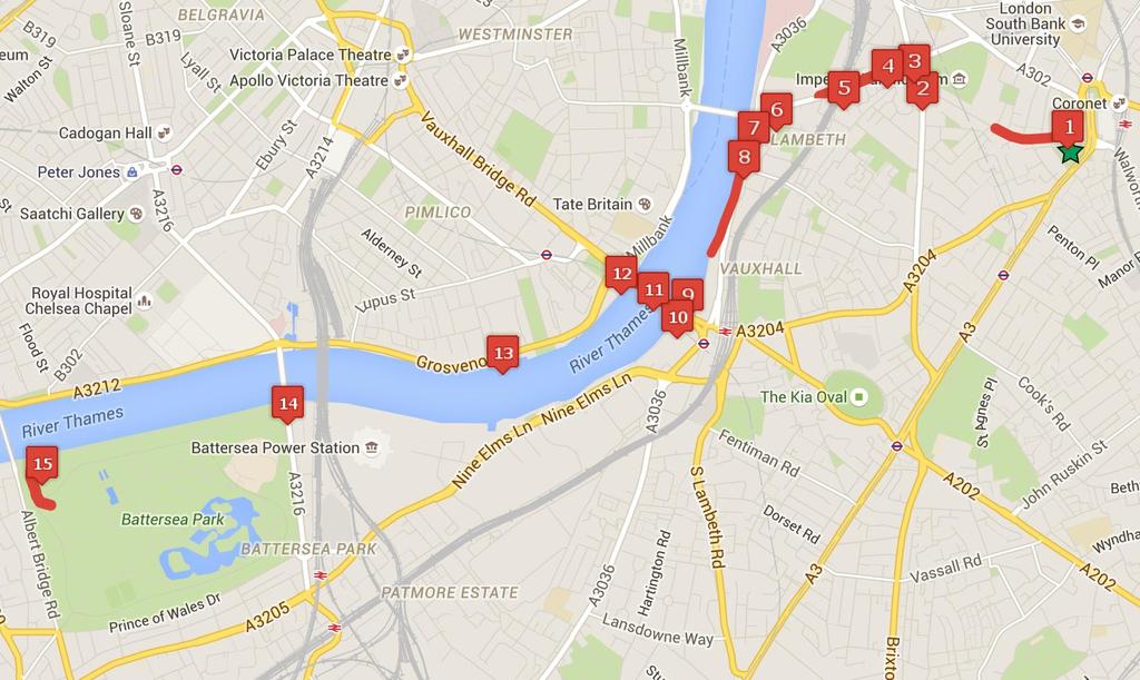
1 Risk Assessment: Monday Run Date Assessed by Location Date of next review 24 May 2016 Sarah Ov, Rachel Wickham and Richard Wingfield Elephant and Castle to Battersea Park via Lambeth, Vauxhall and Pimlico Link to full map: May 2017 (1) Brook Drive Along Brook Drive there are various junctions with side roads where cars drive in or out. Runners could potentially come into contact with a car driving in or out of the side roads. hazard and A map indicating the side roads will be published alongside this Risk Assessment on the Club take caution when running along roads which intersect with side roads.
2 (2) The intersection at Brook Drive and Kennington Road (3) The intersection at Lambeth Road and Kennington Road cross the road (without traffic lights) to get to the circle and could potentially cross the road (with traffic lights) and could potentially Low hazard and A map indicating the crossing will Assessment on the Club A map indicating the crossing will Assessment on the Club
3 (4) Lambeth Road Along Lambeth Road there are various junctions with side roads where cars drive in or out. (5) The intersection at Lambeth Road and Sail Street and the subway under the tunnel Runners could potentially come into contact with a car driving in or out of the side roads. cross the road and could potentially The tunnel is poorly lit which could lead to collisions with runners hazard and A map indicating the side roads will be published alongside this Risk Assessment on the Club take caution when running along roads which intersect with side roads. A map indicating the crossing and the tunnel will be published alongside this Risk Assessment on the Club road and to wear high visibility clothing and take care when running in darkness.
4 (6) The intersection at Lambeth Road and Lambeth High Street (7) The roundabout next to Albert Embankment cross the road (without traffic lights) to get to the circle and could potentially cross the road (with traffic lights) and could come into contact Low hazard and A map indicating the crossing will Assessment on the Club A map indicating the crossing will Assessment on the Club
5 (8) The path by the River Thames parallel to Albert Embankment The path at this point is very narrow and there are often a large number of tourists and other pedestrians. In particular, the bus shelter near the Tamesis Dock makes it difficult to see people coming the other way. (9) A tight blind spot just after the Secret Intelligence Service Runners could come into collisions with Runners could come into collisions with hazard and A map indicating the narrow section will be published alongside this Risk Assessment on the Club be aware of pedestrians and A map indicating the blind spot will be published alongside this Risk Assessment on the Club be aware of pedestrians and
6 (10) The ramp from Riverside Walk to Vauxhall Bridge There is tight turn after the subway under the bridge onto the ramp (particularly when coming back the other way down the ramp to the subway). There is also a slight blind spot when going from the ramp to the Vauxhall Bridge. (11) Vauxhall Bridge The pavement on the left hand side of the bridge is very narrow and right next to a busy Runners could lose their balance if they are running too fast down the ramp. Runners could also come into collisions with pedestrians or other Runners could come into collisions with runners, or with cars if they fell into the hazard and A map indicating the subway and ramp will be published alongside this Risk Assessment on the Club take caution when running round tight corners or down the ramp, as well as to be aware of pedestrians and A map indicating the narrow pavement on the bridge will be published alongside this Risk Assessment on the Club be aware of pedestrians and
7 (12) The bike rack where Vauxhall Bridge meets Grosvenor Road (13) The Shell petrol station along Grosvenor Road There are two points where cars drive in and out of the petrol station. Runners could come into collisions with the bike rack, or cross the road (without traffic lights) and could potentially hazard and A map indicating the bike rack will Assessment on the Club be aware of pedestrians and A map indicating the two points will be published alongside this Risk Assessment on the Club
8 (14) The stairs from Chelsea Bridge Road to the entrance to Battersea Park (15) The north west part of Battersea Park where there is no lighting Runners could trip or fall whilst running up or down the stairs. When running in darkness, runners could come into collisions with hazard and A map indicating the stairs will be published alongside this Risk Assessment on the Club take caution when running up or down stairs. A map indicating the dark part of the park will be published alongside this Risk Assessment on the Club wear high visibility clothing and take care when running in darkness.
9
A Walk from Our Lady of Victories Church, Bowen Hills to The Cathedral of Saint Stephen
 A Walk from Our Lady of Victories Church, Bowen Hills to The Cathedral of Saint Stephen 1 0.0km 30m 185m 270m From the Start to Breakfast Creek Rd is 8 minutes This pilgrimage walk should take the average
01. VICINITY OF GREENBRAE POC: EXISTING CONDITIONS
 01. VICINITY OF GREENBRAE POC: EXISTING CONDITIONS Existing Bus Stop Existing US101 On-ramp Existing POC Old Redwood Highway Rich Street City ROW Environmental Study Limit Industrial Way NO DESIGNATED
Traffic Signs and Signals
 CHAPTER FOUR Traffic Signs and Signals Traffic signs control traffic flow, making streets and highways safer for drivers, bicyclists and pedestrians. These signs, which are posted by the Indiana Department
Cycling Safety Review. (April 2017)
") Cycling Safety Review (April 2017) Background Analysis of STATS19 database: - Only includes incidents where police were in attendance, or where the crash was subsequently reported to the police - Significantly
Cycling Safety Review (April 2017) Background Analysis of STATS19 database: - Only includes incidents where police were in attendance, or where the crash was subsequently reported to the police - Significantly
Everyday Hazards for School Bus Drivers. Reference Guide and Test
 1 Everyday Hazards for School Bus Drivers Reference Guide and Test 2 Introduction One of the most important and often overlooked issues for school bus drivers is hazards. During the course of the video,
Signage and condition of road and pavements on both sides of Chesil Street
 Signage and condition of road and pavements on both sides of Chesil Street Tuesday 26 July and Tuesday 2nd August 2016, both at 6 p.m. Audited by: Janet Berry, Angela Stevenson, Mike Slinn, Phil Gagg,
Emergency Response Support Signage on Multi-Use Trails Plan
 DRAFT ( ) Emergency Response Support Signage on Multi-Use Trails Plan Prepared for: SATS Multi-Use Trails Jurisdictions Committee Table of Contents Introduction... 3 Mileage Markers... 4 Rest Stop Identifiers...
Multi-Modal Traffic Analysis. Parisi and Associates
 Mill Valley to Corte Madera Bicycle and Pedestrian Corridor Study Appendix D: Multi-Modal Traffic Analysis Prepared by Parisi and Associates August 2009 Appendix D - Multi-Modal Traffic Analysis Table
Construction Newsletter No. 32 October 14, 2016 On-Going
 Construction Newsletter No. 32 October 14, 2016 On-Going Here s a block-by-block breakdown of the work currently underway: Harvey Street to Clegg Street: Placement of green thermoplastic for the cycle
Vermont Permit Test Flash Cards
 Vermont Permit Test Flash Cards Study online at quizlet.com/_aormb are the most likely places for car and motorcycle collisions to occur. intersections are areas around trucks where cars disappear 2. :
Signs. signs, signals and road markings. in this chapter
 3 signs, signals and road markings in this chapter Signs regulatory signs school, playground and crosswalk signs lane use signs turn control signs parking signs reserved lane signs warning signs object
Sharing the Road Together. Drivers and Cyclists
 Sharing the Road Together and Date: October 2017 Sharing the Road Together: and Cycling is a fantastic way to get and stay fit. Regular cycling can also help you lose weight and reduce the risk of coronary
Module 5: Navigating Roadways
 Module 5: Navigating Roadways Topic 1: Intersections 1. One out of FATAL crashes occur at intersections. 2. Label the intersection warning signs: 3. When possible, begin searching seconds ahead of the
Rhebogue Neighbourhood Greenway. Road Safety Audit Stage 2
 Rhebogue Neighbourhood Greenway Road Safety Audit Stage 2 Report Number: 12/007/00/00057 July 2014 Mid West National Road Design Office Lissanalta House, Dooradoyle County Limerick Tel: 061 496 800 Fax:
Map and Directions. Walking to raise funds for North London Hospice #bigfunwalk
 Map and Directions Walking to raise funds for North London Hospice 020 8446 2288 www.bigfunwalk.co.uk #bigfunwalk BFW_MAP_2018.indd 1 22/04/2018 21:32 START The Blue Line is the regular route and the Red
Muizenberg Accessibility: Removing barriers to public spaces.
 Muizenberg Accessibility: Removing barriers to public spaces. Refer to SANS 10400-S:2011 Edition 3 of the building code. Note: Facilities that are not in accordance with the requirements of this part of
Start / Finish. Version 2
 Start / Finish Version 2 Gosford (Start) to Woy Woy Head South down Etna Street, crossing Henry Parry Drive, then Mann St, Gosford, where Etna St becomes Racecourse Road. Follow this road all the way
T10:2012 Site Category 1a) T10:2012 Site Category 1b) Railway Level Crossing Approach Traffic Signal Approach Event Code F Event Code E
 T10:2012 Site Category 1b) Railway Level Crossing Approach Traffic Signal Approach Event Code F Event Code E") T10:2012 Site Category 1a) Railway Level Crossing Approach Event Code F T10:2012 Site Category 1b) Traffic Signal Approach Event Code E Traffic signals Crosswalk T10:2012 Site Category 1c) Pedestrian Crossing
T10:2012 Site Category 1a) Railway Level Crossing Approach Event Code F T10:2012 Site Category 1b) Traffic Signal Approach Event Code E Traffic signals Crosswalk T10:2012 Site Category 1c) Pedestrian Crossing
Sharing the Road Together: Drivers and Cyclists
 Sharing the Road Together: and Produced with support from the Department for Transport March 2015 Sharing the Road: and cyclists Cycling is a fantastic way to get and stay fit. Regular cycling can also
Angel Drove carpark 3/day
 GETTING TO ELY ( A on the map below marks the city centre; for a larger scale see the map at the end of the directions, where there are also details of car parking and pedestrian access to the venue) Angel
Speed Control & Limits
 Speed Control & Limits Exceeding the speed limit is a common contributing factor of fatal and other types of accidents. *25 mph* School zones, business or residential districts *55 mph* Certain state highways
VIRTUAL RUNNER. RUNNER INFORMATION PACK Sunday 14th January 2018 The Becket School Nottingham.
 VIRTUAL RUNNER 2018 RUNNER INFORMATION PACK Sunday 14th January 2018 The Becket School Nottingham www.virtualrunneruk.com Welcome to VIRTUAL RUNNER LIVE From VIRTUAL RUNNER Dear Participants, Thank you
BEST PRACTICES FOR ACCESSIBLE TRANSPORT. C G B (Kit) Mitchell
 Mitchell") BEST PRACTICES FOR ACCESSIBLE TRANSPORT by C G B (Kit) Mitchell Independent mobility is necessary for independent living Many people with disabilities use cars, either as driver or passenger Those who
BEST PRACTICES FOR ACCESSIBLE TRANSPORT by C G B (Kit) Mitchell Independent mobility is necessary for independent living Many people with disabilities use cars, either as driver or passenger Those who
Grade-separation for cyclists includes cycling bridges and cycling tunnels, specially built for cyclists and possibly co-used by pedestrians.
 Infrastructure Give Cycling a Push INFRASTRUCTURE/ INTERSECTIONS AND CROSSINGS GRADE SEPARATION Overview Gradeseparation for cyclists includes cycling tunnels and cycling bridges. These are safe and direct
Captain Cook Elementary. Action Details Start Complete Notes
 City of Vancouver Complete School Travel Plan Report Crosswalk improvements on E 55 th Avenue Track progress and collect all relevant ATP information into a School Travel Plan submitted to Captain Cook,
Bellbrook Middle School
 Strategy Type (which of the 5 E s) Strategy Detail Time Frame Responsible Party Status Estimated Cost Possible Funding Source Percent of Students Affected Education Bike Rodeo Completed City of Bellbrook
Office of City Council Member Benjamin J. Kallos Livable Streets Dangerous Intersections
 Office of City Council Member Benjamin J. Kallos Livable Streets Dangerous Intersections 1 244 East 93rd Street, New York, NY 10028 (212) 860-1950 BenKallos.com/Livable-Streets This page intentionally
STATION #3 INITIAL ALTERNATIVES
 www.dot.il.gov www.eisenhowerexpressway.com STATIO #3 IHB RR Heavy Rail Transit (HRT) High capacity transit mode serving urban areas:» Steel wheeled, high performance electric powered rail vehicles» Right-of-way
STAGE #3 TRANSITION 1 at Camp Keystone
 STAGE #3 SWIM STAGE #3 TRANSITION 1 at Camp Keystone Mount bike AFTER bump T1 Changing Tent STAGE #3 Camp Keystone to Marineland 68 MILE BIKE STAGE #3 68 MILE BIKE Mile 0-10 SAG 0.0 Turn RIGHT out of T1.
LONDON BUSES - ROUTE DESCRIPTION
 LONDON BUSES - ROUTE DESCRIPTION Printed On: 04 March 2013 11:29:47 ROUTE 170: Roehampton, Danebury Avenue - Victoria Station, Terminus Place Date of Structural Change: 17 November 2011. Date of Service
See Figure 38, Existing Nonmotorized Connections.
 Nonmotorized Connections Existing Nonmotorized Connections Pedestrian, vehicle and bike traffic access and movements are confined primarily to Penny Drive on campus. Due to the steep slope along the length
Texas Driver Education Classroom and In-car Instruction Model Curriculum
 Texas Driver Education Classroom and In-car Instruction Model Curriculum BasicManeuvering Tasks: Moderate Risk Environment Module Four SPACE MANAGEMENT CONCEPTS CHANGING LANES TURNABOUTS PARKING WORKSHEETS
Marlow River Olympic Distance Triathlon. Sunday July 15th 2012, 6:00am - 12:00pm. Olympic Distance 1500 metre Swim, 37km Bike, 7.
 Marlow River Olympic Distance Triathlon Sunday July 15th 2012, 6:00am - 12:00pm Olympic Distance 1500 metre Swim, 37km Bike, 7.45km Run Competitor notes Thank you for entering the Maxifuel Marlow River
Poor pavement condition Substandard Intersections. / Substandard bike/pedestrian/transit accommodations. Driveway access Environmental concerns
 Public Informational Meeting University Avenue (Allen Boulevard Segoe Road) March 23, 2011 City of Madison City of Middleton Village of Shorewood Hills Dane County Existing Roadway Conditions Poor pavement
laws AnD rules of the road ight-of-way rules General Information Respect Respecting respect Pedestrians Important:
 LAWS AND RULES OF THE ROAD Right-of-Way Rules General Information Right-of-way rules, together with courtesy and common sense, help to promote traffic safety. It is important to respect the right-of-way
That the agenda for the Colwood Cycling Advisory Committee meeting of Thursday Sept. 8th 2016 be approved as presented. CARRIED.
 CITY OF COLWOOD MINUTES OF COLWOOD CYCLING ADVISORY COMMITTEE MEETING Thursday September 8, 2016 @ 5:00p.m. 3300 Wishart Road Colwood BC Council Chambers DATE: Thursday September 8, 2016 @ 5:00p.m. Committee
Module 2 SAFE MOTORISED WHEELCHAIR PRACTICES. NRMA-ACT Road Safety Trust
 Module 2 SAFE MOTORISED WHEELCHAIR PRACTICES NRMA-ACT Road Safety Trust To understand the importance of planning & preparation To learn general road safety principles To be aware of safe motorised wheelchair
Traffic safety manual for the citizens of the Sultanate of Oman.
 Traffic safety manual for the citizens of the Sultanate of Oman. A traffic safety manual designed for the citizens of Oman for the age s between 18-30. Created by: Al Balushi, Khadija April 25 th, 2014
Niantic Center Elementary School
 Niantic Elementary School is located in the Northwest corner of the intersection of West Main Street and East Pattagansett Road, as so noted on the Facility Location Map. location Overview: The site is
section 4 Existing Conditions, Issues, and Options
 section 4 Existing Conditions, Issues, and Options 4.0 Existing Conditions, Issues, and Options This section analyzes each segment of the corridor on a street to street basis. Each segment is discussed
SLOUGH Stage 3 Road Safety Audit of A4 London Road, M4 J5 to Sutton Lane
 SLOUGH Stage 3 Road Safety Audit of A4 London Road, M4 J5 to Sutton Lane Exception Report Client Officer Rudo Beremauro Date 20 January 2015 RSA /Project Sponsor s Contents Section 3 Project Sponsor's
LONDON BUSES - ROUTE DESCRIPTION
 LONDON BUSES - ROUTE DESCRIPTION Printed On: 04 March 2013 11:37:19 ROUTE 333: Tooting Broadway - Elephant & Castle Date of Structural Change: 23 January 2010. Date of Service Change: 23 January 2010.
Southside Pilot Proposal
 To improve bicycle access and mobility to UC Berkeley, Downtown Berkeley, and the Southside area, a pilot project could include a two-way parking-protected cycle track. Turn pockets and island bus stops
Beginning School Bus Driver Curriculum UNIT IX. FIELD TRIPS and TRAFFIC CONTROL DEVICES. Revised 09/2011 Revised 10/2013 (Instructional Content)
") Beginning School Bus Driver Curriculum UNIT IX FIELD TRIPS and TRAFFIC CONTROL DEVICES Revised 09/2011 Revised 10/2013 (Instructional Content) Unit IX FIELD TRIPS AND TRAFFIC CONTROL DEVICES TABLE OF CONTENTS
Beginning School Bus Driver Curriculum UNIT IX FIELD TRIPS and TRAFFIC CONTROL DEVICES Revised 09/2011 Revised 10/2013 (Instructional Content) Unit IX FIELD TRIPS AND TRAFFIC CONTROL DEVICES TABLE OF CONTENTS
Physical Activity School Scan (PASS) ASSESSMENT GUIDE
 ASSESSMENT GUIDE") Physical Activity School Scan (PASS) ASSESSMENT GUIDE GENERAL INSTRUCTIONS The purpose of this protocol is to support the use of the Physical Activity School Scan (PASS) in the assessment of primary school
Physical Activity School Scan (PASS) ASSESSMENT GUIDE GENERAL INSTRUCTIONS The purpose of this protocol is to support the use of the Physical Activity School Scan (PASS) in the assessment of primary school
Midtown Rail Station Accessibility Assessment N4
 Midtown Rail Station Accessibility Assessment N4 Joel Anders, Arnaud Huguet, and Alex Poznanski 15 August 2012 Table of Contents EXECUTIVE SUMMARY... 1 MISSION STATEMENT... 2 INTRODUCTION... 2 CROSSWALKS
Report from Embassy Visit to Copenhagen May David Arditti
 Report from Embassy Visit to Copenhagen May 2013 David Arditti Standard CPH cycle track, one-way 1.5 2m wide, 5cm above carriageway, 5cm below footway Basic one-way cycle track protected by car parking
Welcome.
 Welcome Concept view of Nine Elms Pimlico Bridge with Battersea Power Station in the distance A need has been identified for a new bridge connecting Nine Elms and Pimlico. We would like to hear the views
North Buckhead Civic Association. Recommendations For Wieuca Road
 North Buckhead Civic Association Recommendations For Wieuca Road October 7, 2009 Blank Page Page 2 of 16 Table of Contents 1. BACKGROUND 4 2. TRAFFIC SIGNALS AND ALL WAY STOPS 5 3. SPEED LIMITS AND SPEED
Copenhagen Cycling Map. Red Lines Cycling facilities
 Copenhagen Cycling Map Red Lines Cycling facilities Copenhagen Cycling Facilities Design Approaches Transportation without Pollution Copenhagen s Strategy Where Cycling is one of the top key activities
The Year Of Mercy Pilgrimage Sts Peter and Paul s Church, Bulimba To The Cathedral of St Stephen
 The Year Of Mercy Pilgrimage Sts Peter and Paul s Church, Bulimba To The Cathedral of St Stephen Dist Route Photos Photos 0.0km St Peter and Paul s Church, 235 Riding Rd & Cnr Main Ave, Balmoral. http://www.bulimbacatholic.com/
Chapter 14 Challenging Driving Conditions
 Chapter 14 Challenging Driving Conditions 14-1 REDUCED VISIBILITY A. Complete each of the following sentences by writing the correct word or phrase in the space provided. 1. percent of a driver s ability
Cycle routes from Guildford
 Cycle routes from Guildford The following five pages give practical information about following the main cycle routes from Guildford. There are now several good trafficfree routes in the area, and Guildford
Tunnel Reconstruction Brooklyn CB 1 August 14, 2018
 Tunnel Reconstruction Brooklyn CB 1 August 14, 2018 Reconstructing the Tunnel 2 Service During Tunnel Reconstruction April 2019 through July 2020 3 Projected Cross River Travel Paths of Customers The Service
THE BLOCK MUSEUM IS OPEN DURING CONSTRUCTION!
 THE BLOCK MUSEUM IS OPEN DURING CONSTRUCTION! DRIVING DIRECTIONS From the south: Arts Circle Drive is closed due to a construction project on Northwestern s south campus. The following information tells
Instructions for Completion of Hazard Evaluation Requests
 44-36 Vernon Boulevard, Long Isl City, NY 11101 Telephone: (718) 392-8855 Instructions for Completion of Hazard Evaluation Requests - 2017-2018 Please read carefully follow all instructions incomplete
Identify the letter of the choice that best completes the statement or answers the question.
 Chapter 02 - Practice Questions Multiple Choice Identify the letter of the choice that best completes the statement or answers the question. 1) No-parking zones often are near a. fire hydrants, curves,
2016 Hertfordshire Triathlon Spring Sunday 28 th August
 Dear Race Entrant, Race Details This is your race information pack for the Hertfordshire Triathlon Spring and the Hertfordshire Triathlon Club Champs. ActiveTrainingWorld would like to thank Moveology,
Bicycle Pedestrian Master Plan Pre Bid Meeting Portsmouth, NH August 15, 2013
 Bicycle Pedestrian Master Plan Pre Bid Meeting Portsmouth, NH August 15, 2013 2005 Master Plan GOAL: Provide for safe and convenient bicycle and pedestrian circulation throughout the City. Develop a city
APPENDIX 1 CITY OF CALGARY SHARE THE PATHWAY PROGRAM
 APPENDICES APPENDIX 1 CITY OF CALGARY SHARE THE PATHWAY PROGRAM Share the Pathway Share the pathway and share the responsibilities. Those who use the pathway get along better when they show courtesy and
Site Improvements
 Sections Included In This Standard: 1.1 Bicycle Facilities 1.2 Guardrails 1.3 Parking Bumpers 1.4 Traffic Signage 1.5 Traffic Signals 1.6 Traffic Impact Studies 1.7 Vision Triangle 1.8 Bus Stop Shelters
Charles River Pathways
 Charles River Pathways Dr. Paul Dudley White Bike Path Museum of Science to Watertown Square Analysis of the South Shore with conceptual design Proposal Charles River Conservancy August 2006 Prepared by
Easton Safer Streets - Final Project Report BRISTOL
 - Final Project Report BRISTOL A Sustrans Community Street Design Project in partnership with Bristol City Council February 07 About Sustrans Sustrans makes smarter travel choices possible, desirable and
The Hundred Parishes
 The Hundred Parishes Walks from railway stations number 9 6.4 miles (10kms) from Bishop s Stortford to Stansted Mountfitchet Start: Bishop s Stortford station (Grid Reference TL492209) (ample parking and
Lynchburg District Update
 Lynchburg District Update Virginia Statewide Bicycle and Pedestrian Advisory Committee Spring Meeting May 16 th, 2017 David Cook Transportation Planner, VDOT Lynchburg District Table of Contents Active
Cottonwood Heights HAWK Pedestrian Crossing on Fort Union Blvd. Project Type Capital Improvement
 Cottonwood Heights HAWK Pedestrian Crossing on Fort Union Blvd. At West Side of Mountview Park Entrance (Approx. 1600 East) $ 206,800 $ 192,800 Install a HAWK Pedestrian Crossing System on Fort Union Boulevard,
Improvements Infrastructure Gap Assessment and Improvements Street Striping
 Infrastructure Project Proposal The federal-aid Safe Routes to School program funds infrastructure/engineering projects that fall into two categories: Design (available only to School Development Authority
4.7 Best Route to School Maps and Mapping
 4.7 Best Route to School Maps and Mapping A school route map informs families of the safest and most convenient walking and bicycling routes to school. These are often created after a Neighbourhood Walkabout
Launton to Bicester nature footpath improved
 Launton to Bicester nature footpath improved Published 13 July 2012 An attractive rural footpath linking Launton to Bicester has brought back into use by the council's Countryside team. Staff have improved
Design Guidelines. Overview. Design Vision for Yellow Brick Road
 Design Guidelines Overview This section presents the design vision for the Yellow Brick Road network. The Yellow Brick Road is envisioned to be an interconnected network of safe and secure roadways where
62.21 miles. RVCR 100K Starts In Phoenix, Oregon. 2,595ft Max 1,060ft Min +2,185ft -2,172ft 5.8 % 1 2. Page 1 of 1
 RVCR 100K Starts In Phoenix, Oregon 62.21 miles 2,595ft Max 1,060ft Min +2,185ft -2,172ft 5.8 % 1 2 Rogue Valley Challenge Relay 100K Find this route online at mapmyrun.com/ routes/ view/34000740 RVCR
Side Roads and Other Non-Signalised Junctions
 Green Surfacing Sections of the Cycle Superhighway are marked with green paint these highlight sections where people cycling the Superhighway are likely to come into contact with walkers, drivers, or other
Non-motorised wheeled access to Canterbury city centre from the A28/Wincheap corridor
 Non-motorised wheeled access to Canterbury city centre from the A28/Wincheap corridor (or, Why do cyclists always ride on the pavements?) A Report by the Wincheap Society June 2017 The A28 Wincheap is
Healthy Hospitals Physical Activity Scan * Required
 * Required 1. Rater ID * Insert here the ID# you were assigned for the project 2. Hospital ID * Insert here the ID# for the hospital you are scanning today Page 1 of 15 3. Hospital Name * 4. Scan Date
WELLS WAY GREEN PARK ROAD
 FOBP Discussion Document February 2015 WELLS WAY GREEN PARK ROAD Wells Way looking from Albany Road through Burgess Park Introduction Burgess Park provides much needed and loved recreational space for
Chicago Safe Routes to School Safe Routes to High School (SRTS/SRTHS)
") Chicago Safe Routes to School Safe Routes to High School (SRTS/SRTHS) Marshall Community High School and Faraday Elementary School Recommended Improvements Agenda Goals Related Programs Project Location/Area
Chicago Safe Routes to School Safe Routes to High School (SRTS/SRTHS) Marshall Community High School and Faraday Elementary School Recommended Improvements Agenda Goals Related Programs Project Location/Area
Sharing London s roads
 Sharing London s roads Advice for drivers and cyclists MAYOR OF LONDON Transport for London Sharing London s roads 1 Introduction and drivers need to work together to share London s roads safely. By following
Summary of School Observations and Education and Encouragement Initiatives
 Rye Shared Committee Summary of School Observations and Education and Encouragement Initiatives Presented to the Rye City Council & The Rye City School District Board of Education April 9 th, 2011 1 Why
Transportation Planning Division
 Transportation Planning Division Presentation Outline Study Tasks Recap of Previous Meetings Data Collected Focus Areas within Study Limits Design Principles Tool Box Recommended Concepts Schedule Moving
Two Tunnels Railway Races Event Information
 Two Tunnels Railway Races Event Information Important Notices Brickfields Park, Bath, BA2 1LX 18th Feb, 09:20am There is no on street parking available for runners on the streets around Brickfields. Please
Technical Instructions Manual
 Technical Instructions Manual Directions from Beatty Hall to the Museum of Science, Boston Kevin Tang Kyle Morin Rachel Rotman Timothy Hewitt Wentworth Institute of Technology November 2009 Table of Contents
PROJECT SUMMARY ALBERTA STREETSCAPE PROJECT
 ALBERTA STREETSCAPE PROJECT Revitalizing a Street Rebuilding a Community Realizing a Dream PROJECT SUMMARY December 2001 Project Background In 1998 and 1999, the Alberta Street community was engaged in
Route Item and Subscale Reliability Table All Countries
 Route Item and Subscale Reliability Table All Countries Route Land Use: Residential Density Item Item Content Range N Inter-Rater Agreement Rater Mean (SD) Frequencies LU2a Single family homes 0-1 407.926
About The Big Bend Open Road Race U.S 285 Course Notes
 2018 About The Big Bend Open Road Race U.S 285 Course Notes Course notes for 2018, Ft. Stockton to Sanderson and return. * Please note that these course notes are based on the 2017 race. You will notice
Watertown Complete Streets Prioritization Plan. Public Meeting #1 December 14, 2017
 Watertown Complete Streets Prioritization Plan Public Meeting #1 December 14, 2017 Goals for Public Meeting Overview of MassDOT Complete Streets Funding Program Educate the community on Complete Streets
Bulwell Cycling Consultation
 Bulwell Cycling Consultation Image 1 Bulwell Bogs (Sutton, 2015) As part of a final year research project, I am seeking feedback on proposals for cycling improvements in Bulwell. This consultation is not
Morgans Creek to Padstow
 Morgans Creek to Padstow 2 hrs 45 mins 8 km One way Moderate track 3 144m This pleasant walk starts from the Morgans Creek park, at Henry Lawsons Drive, and follows the Georges River past the Boomerang
SCHEDULES OF TRAFFIC CALMING IN THE CZECH REPUBLIC
 SCHEDULES OF TRAFFIC CALMING IN THE CZECH REPUBLIC Zdeněk Hrubý, Eva Simonová CDV Transport Research Centre Czech Republic e-mail: hruby@cdv.cz or simonova@cdv.cz REDESIGN OF TROUGHPASS OF HIGHWAY I/17
Bikeability Checklist
 Bikeability Checklist How bikeable is your community? Riding a bike is fun! Bicycling is a great way to get around and to get your daily dose of physical activity. It's good for the environment, and it
Appendix A. Knoxville TPO Greenway Signage Guidelines. Appendix A: Knoxville TPO Greenway Signage Guidelines Knox to Oak Ridge Greenway Master Plan
 Appendix A Knoxville TPO Greenway Signage Guidelines 75 Overview: Adequate signing and marking are essential on shared-use paths, especially to alert bicyclists to potential conflicts and to convey regulatory
Pass your Driving Test with confidence
 Pass your Driving Test with confidence Sample theory questions, and answers to help you prepare for your driving test. Q1. When should you not drive? While under the influence of alcohol, drugs (prescribed
Regulatory traffic signs
 Section 21: Regulatory traffic signs This section includes the signs that show a road regulation is in place. These must be obeyed. Regulatory signs show the course a driver must follow and an action they
Derby Cycling Group, c/o 126, Station road, Mickleover, Derby, DE3 9FN. Date: 20 th November, 2018.
 Your Ref: Derby City Council Air Quality - Preferred Option Nov 2018 Derby Cycling Group, c/o 126, Station road, Mickleover, Derby, DE3 9FN Date: 20 th November, 2018. 1. Introduction: 1.1. Derby Cycling
in the pop-up survey after drawing it. UPLOAD PHOTOS when you add a route or point or by clicking on an existing route or point.
 Introduction As part of the first phase for the West Elizabeth Enhanced Travel Corridor Plan an online interactive map WikiMap was created and available for input. A link to the WikiMap was distributed
CHECKLIST 2: PRELIMINARY DESIGN STAGE AUDIT
 CHECKLIST 2: PRELIMINARY DESIGN STAGE AUDIT 2.1 General topics 2.1.1 Changes since previous audit Do the conditions for which the scheme was originally designed still apply? (for example, no changes to
BICYCLE RULES OF THE ROAD
 ILLINOIS ILLINOIS ILLINOIS ILLINOIS ILLINOIS ILLINOIS ILLINOIS ILLINOIS BICYCLE RULES OF THE ROAD Jesse White Secretary of State Bicycle riding is a great way to get into shape and enjoy the outdoors.
Pedestrians under high-risk despite technological improvements
 Pedestrians under high-risk despite technological improvements Protecting them with a new paradigm and the help of Vision Zero. In Argentina, 22% of deaths in traffic are pedestrians. In Buenos Aires City,
TRAFFIC CALMING PLANNER S PORTFOLIO
 TRAFFIC CALMING PLANNER S PORTFOLIO ISSUE 8 January 2017 PLANNER S PORTFOLIO TRAFFIC CALMING 1 OVERVIEW 2 3 4 ENGINEERED TRAFFIC CALMING MEASURES SIGNS AND PAVEMENT MARKINGS EMERGENCY RESPONSE DELAYS 5
PLEASE READ THE RACE INSTRUCTIONS
 RACE INFORMATION Event Date: 30th September Venue: Ancholme Leisure Centre, Brigg, North Lincolnshire Start Time: 8:00am Race Registration: Saturday 29rd Sept 5.00pm 6.00 pm Sunday 24th Sept 6:00am 7:00am
LTAC: Katie Mencarini, Central & Hampton Roads streets and a fifteen minute debrief to discuss the findings. Participants walked along Mill Road
 Walkabout Summary On June 3, 2013, five participants met at Glen Allen Elementary School in Glen Allen, Virginia to take a closer look at the walking and biking network around the school. In addition to