REPORT DP Development Approval & Planning Policy Department
|
|
|
- Gregory Sims
- 6 years ago
- Views:
Transcription
1 To: From: Mayor and Members of Council Development Approval & Planning Policy Department Meeting: Subject: Informational History on the Planning of Trails within the Chateaux of Caledon/Brookfield Homes Pathways Subdivision RECOMMENDATIONS That Report DP regarding Informational History on the Planning of Trails within the Chateaux of Caledon/Brookfield Homes Pathways Subdivision, be received for information; and That Development Approval and Planning Policy Department be directed to add a clause in any future Subdivision Agreement, which is registered on title, that all Purchase and Sale Agreements where applicable include a warning clause regarding the width of sidewalk to make new homeowners aware that a wider than standard sidewalk may be located in front of their property; and That Development Approval and Planning Policy Department be directed to ensure that any future subdivision include a note on the developer/builder Sales Office Plan, that reminds purchasers to confirm with the Development Approval and Planning Policy Department final locations of sidewalks and infrastructure/utilities to be located within the road right of ways in front of their property. ORIGIN/BACKGROUND On Tuesday April 3, 2012, two residents within the Chateaux of Caledon/Brookfield Homes Pathways Subdivision ( Chateaux ), delegated Council with concerns about the planned installation of a 2.0 metre (6.5 foot) wide sidewalk on the north side of Paisley Green Avenue within the development. The delegates requested clarification on both the requirement for the sidewalk and its proposed width. Concerns raised by the delegates included the close proximity of the sidewalk to the front façade of their home, therefore creating privacy issues. Staff identified at the Council meeting that the particular sidewalk in question is part of a larger pedestrian network for the Caledon East community. As a result of the delegation, Council recommended that staff provide an information report back to Council on the planning history for pedestrian movement within the Chateaux subdivision. The Chateaux subdivision is located in Caledon East on the north side of Old Church Road between Airport Road and Innis Lake Road. The subdivision is ha (85.89 ac) in size (see Appendix A Approved Draft Plan of Subdivision). The subdivision is currently registered with phase 2 being draft approved, to develop approximately 471 residential units comprised of a mix of single detached dwellings, linked dwellings, live/work townhouse dwellings and townhouse dwellings. The subdivision plan also Page 1 of 8
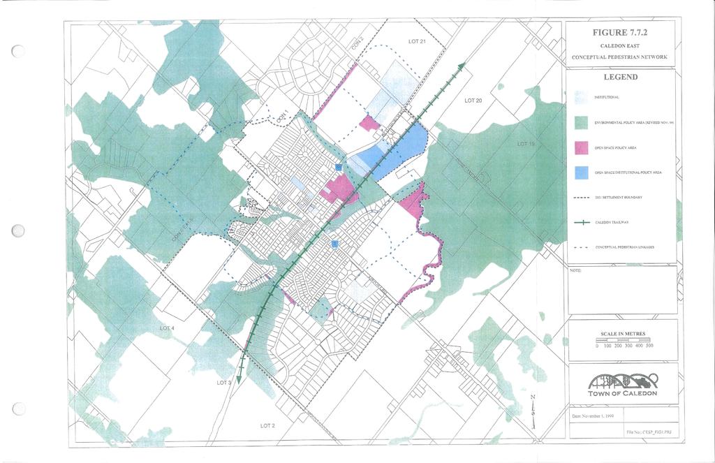
2 includes a small commercial block, open space, trail linkages, a neighbourhood park and a storm water management facility. The subdivision is planned to be built over several phases. To date 191 building permits have been issued for the first phase of development. DISCUSSION As highlighted in the marketing for the Chateaux development, walkability and pedestrian connectivity were an important design objective in the overall planning of the subdivision. The Caledon East Secondary Plan, Official Plan Amendment ( OPA ) 219, the Caledon East Streetscape Study - Architectural Guidelines and Streetscape Study Addendum influenced the final approved layout of the subdivision. Caledon East Secondary Plan The Caledon East Secondary Plan ( CESP ) is a component of the Town s Official Plan. The establishment of the CESP was a detailed and community driven process that was Council approved in July, The CESP recognizes that Caledon East is a key focal point along the Caledon Trailway and that pedestrian connectivity within Caledon East to the overall Town of Caledon trail network is an important planning objective. One of the specific objectives of the CESP is Policy (h) To encourage and facilitate pedestrian activity by providing a system of open spaces, trails and pedestrian walkways that interconnect the residential neighbourhoods, the core community facilities and the Caledon Trailway. Based on an objective of community walkability and pedestrian connectivity to public spaces and community facilities, the structural concept for the CESP identified the importance of planning Caledon East with trails and linkages that connect residents to the parks, environmental policy areas, schools, the village core and residential neighbourhoods. By providing the connectivity, it will enhance public safety and community interaction. The preparation of the CESP included extensive public consultation. Public input reinforced the importance of trails and pedestrian connectivity in Caledon East by identifying both improvements to existing trails as well as, the need for new trails that would encourage walkability. Along with the approval of the CESP a conceptual layout for open space linkages was prepared. The layout identified a pedestrian connection across the lands, which are now being developed as the Chateaux subdivision. At the time of the CESP approval, there was no development application submitted for the Chateaux lands; therefore there were no detailed studies or information to identify an ultimate location for a trail. Without detailed development information, the desired trail connection was shown conceptually along the northern limits of the subdivision lands running in an east west alignment establishing a connection from Boyce s Creek to Innis Lake Road, as shown in Appendix B - Figure Caledon East Conceptual Pedestrian Network (Official Plan). Official Plan Amendment 219 An Official Plan Amendment ( OPA ) application was submitted to the Town in November of The application was specifically for the Chateaux subdivision lands. Page 2 of 8
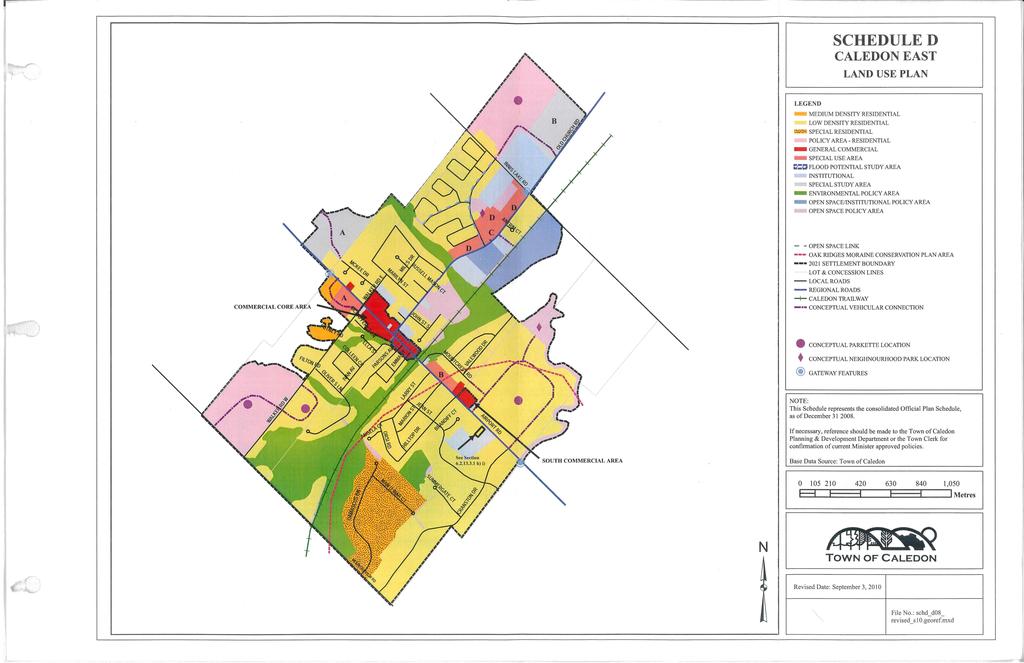
3 The amendment which was approved as OPA 219 by Council on December 9, 2008, permitted the inclusion of retail commercial uses, modifications to the size and location of the neighbourhood park, redesignation of a portion of institutional lands to for low density residential and redesignation of the open space policy area on the land to permit low density residential. As part of the redesignation of the open space policy area, the trail linkage which was initially to be established along the north property line of the subdivision was amended to be included within the subdivisions road network. The OPA amendment included a revision to Schedule D Caledon East Land Use Plan to illustrate a revised location for pedestrian and trail connections within the subdivision (see Appendix C, Schedule D Caledon East Land Use Plan.) Where the CESP illustrated a very conceptual trail connection through the Chateaux lands, Schedule D in OPA 219 illustrates the open space linkages as being more centrally located within the Chateaux subdivision and specifically shows connections associated with the subdivision road network in the same location where Paisley Green Avenue is now found. A public information meeting was held on Wednesday August 6, 2008 to receive public input on the amendment. The current layout for pedestrian connections and trails in the Chateaux subdivision is consistent with the current Schedule D- Caledon East Land Use Plan. Caledon East Streetscape Study - Architectural Guidelines and Streetscape Study Addendum The Caledon East Streetscape Study ( CESS ) was completed in The study was undertaken to examine existing streetscape conditions in Caledon East and develop guidelines for enhancing both the streetscape and architectural form within the village. An addendum to the study was prepared in The addendum expanded the original study limits and updated some of the guideline requirements. The CESS was prepared through public input. The study defined key pedestrian linkages, trails, community activity nodes and gateways within Caledon East. Objectives of the study included enhancing walkability within the village and establishing connectivity between the residential areas and the commercial core. Connectivity is to be achieved through trails and the road system. As the original approved CESS did not include the Chateaux subdivision. The 2009 addendum provided new detail on how the subdivision should conform to the CESS through its design and layout of streetscapes, pedestrian connections and architectural form. The addendum highlights that trail connections need to be integrated into the streetscape design. Chateaux of Caledon Residents Advisory Group By recommendation of the Ward 3 Councillors, a Chateaux of Caledon Residents Advisory Group was formed. The group consisted of approximately eleven local Caledon East residents who met frequently during the subdivision planning stages to ensure that the new development would conform to the CESP. The committees review included providing input on the location of trails and pedestrian connections for the subdivision. This input helped to ensure that there was connectivity within the subdivision and to Caledon East. Page 3 of 8
4 Council Report PD Council Report PD Draft Plan of Subdivision, Official Plan Amendment, Rezoning Application and Associated Draft Plan of Condominium Application Part Lot 21, Concession 1 (Albion) Chateaux of Caledon o utlined the requirements for an enha nced sidewalk system within Chateaux. The enhanced sidewalk addressed the removal of the trail linkage running adjacent to Chateaux s northern property boundary as shown in CESP and re-confirmed the trail linkage being established within the subdivisions road network as illustrated in OPA 219, Schedule D Caledon East Land Use Plan. The enhanced sidewalk was to be incorporated on key streets that would establish the necessary open space and trail connections for the community. Although it was not defined in the report, the term enhanced sidewalk, referred to the implementation of a sidewalk that is wider then the standard 1.5 metre (5 foot) width. Current Approved Pedestrian Network Chateaux draft plan of subdivision was approved by Council on January 13, 2009 and red line revised and approved by the Director of Development Approval and Planning Policy on September 3, The current pedestrian connections and wider sidewalks planned for Chateaux subdivision, conforms to the Caledon East Secondary Plan, OPA 219, the Caledon East Streetscape Study - Architectural Guidelines and Streetscape Study Addendum and input provide by the Chateaux of Caledon Advisory Committee. A 2.0 metre (6.5 foot) wide sidewalk is planned for north side of Paisley Green Avenue (Street B on Appendix A Approved Draft Plan of Subdivision) and on the east side of Atchison Drive (Street A on Appendix A Approved Draft Plan of Subdivision). These 2.0 metre (6.5 foot) wide sidewalks establish community connections with the open space block in the northwest corner of the subdivision, the park, St. Cornelius School, commercial block and Town Square (located on the northeast corner of the intersection at Atchison and Old Church Road). The connection to the open space block also provides a further trail connection beyond the subdivision into the Boyce Creek Trail system and to Marilyn Drive. The subdivision also provides trail connections in the form of numerous 2.0 metre (6.8 foot) and 2.5 metre (8.2 feet) wide walkway blocks and trail connections through the storm water management facility. The subdivision also proposes enhanced streetscape and pedestrian sidewalks along the north side of Old Church Road and the west side of Innis Lake Road. These sidewalks are also proposed to be 2.0 metres (6.5 feet) in width to promote walkability and safe connections to both St. Cornelius School and Robert F. Hall Secondary School. Please refer to Appendix A Draft Plan of Subdivision Plan which illustrates the various pedestrian networks within the Chateaux. The 2.0 metre (6.5 foot) wide sidewalk is provided to encourage walkability and provide a more comfortable pedestrian connection for residents and children to commute to public facilities including the nearby schools. The wider 2.0 metre (6.5 foot) sidewalk is a Town engineering standard that has been incorporated into other subdivisions in Caledon. For example, Oxford Homes on Borland Crescent (near Walker s Road) in Caledon East has a 2.0 metre (6.5 foot) wide sidewalk incorporated into the streetscape system of the development. In addition, the Strawberry Fields subdivision in Mayfield West has incorporated a combination of 2.0 metre (6.5 foot) and 3.0 metre (9.8 feet) wide sidewalks within residential areas to encourage walkability. The remainder of the roads within the Chateaux subdivision incorporate a standard 1.5 Page 4 of 8
5 metre (5 foot) wide sidewalk on one side of the road. Paisley Green Avenue and Atchison Drive are the only two streets in the subdivision, which have both a 2.0 metre wide sidewalk on one side of the road and a 1.5 metre (5 foot) wide sidewalk on the opposite side of the road. The 2.0 metre (6.5 foot) wide sidewalk on Paisley Green Avenue is not included along the entire length of the road, instead is along a section of the road where a connection can be established between the open space block and Atchison Drive/ the neighbourhood park. All sidewalks planned in the Chateaux subdivision are located completely within the Town s road right of way. The Town s engineering standards require, where possible, that all sidewalks are located on the same side of the road as schools, parks and other amenities that are pedestrian generators. All sidewalks no matter the width are setback a consistent 0.5 metres (1.6 feet) from all private property lines. Utility corridors, hydro transformers, fire hydrants, water mains and streetlights are all located at the back of curb, which prevents the sidewalk from being located closer to the street curb. As shown in Appendix D Town of Caledon Engineering Standard No. 204, sidewalks are offset from the infrastructure/utilities to protect the sidewalk from being damaged or removed whenever infrastructure/utility repairs are required. Additionally, Town winter maintenance operations necessitates areas for snow storage within the public boulevards, to avoid conflict with snow storage areas, sidewalks are located away from the back of street curb and closer to the private property line. The sidewalks are designed and laid to meet Town of Caledon engineering standards so that they can be accessible for the community and easily maintained by the Town. Comprehensive Zoning Bylaw , as amended The houses that are located on Paisley Green Avenue which have the 2.0 metre (6.5 foot) wide sidewalk within the road right of way in front of their property, are zoned Residential/R1-E (214). Under the approved zoning of R1-E (214), the residential lots must have: a minimum frontage of 16 metres (52.5 feet) on a corner lot and 14 metres (46 feet) on an interior lot, the front building setback shall be a minimum of 6.0 metres (19.7 feet) from an attached garage and 4.5 metres (14.8 feet) from the wall of a main building (this does not include a front porch or deck which may have less than the 4.5 metre (14.8 feet) setback from the front property line); and garage projections are not permitted beyond the front wall of the main building. Based on the minimum 4.5 metre (14.8 feet) setback of the house to the front property line and the requirement for the sidewalk to be setback 0.5 metres (1.6 feet) from a private property line; the front wall of the houses on Paisley Green Avenue are located a minimum of 5.0 metres (16 feet) from the edge of the sidewalk. Where resident concerns may be raised that the sidewalk can hinder parking in the driveway, the R1-E (214) zoned residential lots were designed to accommodate four parking spaces. All four parking spaces are located within the private property, two within the double car garage and two within the driveway. As highlighted above, the zoning requires the front wall of the garage to be setback 6.0 metre (19.6 feet) from the property line. When the 6.0 metre (19.6 feet) setback is combined with the 0.5 metres (1.6 feet) setback for the sidewalk location inside the property line of the road right of Page 5 of 8
6 way, there is a total length of 6.5 metre (21.3 feet) in the residential driveway from garage to edge of sidewalk. FINANCIAL IMPLICATIONS There are no immediate financial implications associated with this report. LEGAL IMPLICATIONS The Subdivision Agreement, which is registered on title, for the first phase was executed by all parties on or around April 13 th, The M-Plan creating the lots and blocks within the first phase was registered on May 5 th, As such, it is not recommended that this Subdivision Agreement be modified. The Planning Law Office will ensure that all future Subdivision Agreements relating to the Chateaux Subdivision will obligate the developer and builder to include warning clauses in each of its Purchase and Sale Agreements advising potential purchasers that a wider sidewalk may be located in front of their property. The terms of the warning clauses will be approved by Town staff. NEXT STEPS To ensure that new residents in a new subdivision are made aware when a wider sidewalk will be located in front of their property, Development Approval staff shall prepare and include a condition within future Subdivision Agreements that requires the builder/developer to include a warning clause which identifies the wider sidewalk within t heir resident Purchase and Sale Agreements. Staff will also require as part of any future subdivision, that the illustrative Sales Office Plan used by the developer/builder to show the subdivision layout to potential purchasers, include a note which reminds purchasers that a sidewalk, wider sidewalk, street lights and utility boxes may be located in front of their property and to confirm the final location of infrastructure/utilities with the Town of Caledon, Development Approval and Planning Policy Department. COMMUNITY BASED STRATEGIC PLAN Goal 1: PARTNER WITH LAND OWNERS AND COMMUNITY TO PRESERVE, PROTECT AND ENHANCE OUR ENVIRONMENT AND AGRICULTURAL RESOURCES AND NATURAL CAPITAL Strategic Objective 1C - Support Green Energy and Energy Reduction Strategic Objective 1D - Promote Green Living and Build Community Capacity Goal 2: COMPLETE OUR COMMUNITY OF COMMUNITIES Strategic Objective 2E - Provide a High Quality Public Realm Strategic Objective 2F - Connect Neighbourhoods Goal 3: LIVE HEALTHY Strategic Objective 3A - Enhance Active Living Opportunities Page 6 of 8
7 POLICIES/LEGISLATION Town of Caledon Official Plan Caledon East Secondary Plan OPA 219 Caledon East Streetscape Study - Architectural Guidelines and Streetscape Study Addendum Council Report PD Zoning Bylaw , as amended The Public Works & Engineering, Development Standards, Policies and Guidelines CONSULTATIONS Geoff Hebbert, Senior Development Engineer Craig Campbell, Director of Public Works Casey Blakely, Community Development Planner ATTACHMENTS Appendix A Approved Draft Plan of Subdivision Appendix B Figure Caledon East Conceptual Pedestrian Network (Official Plan). Appendix C - Schedule D Caledon East Land Use Plan Appendix D - Town of Caledon Engineering Standard No. 204 CONCLUSION Based on resident concerns, Council has recommended that staff prepare an informational background report to explain why wider sidewalks are located within the Chateaux subdivision. The current layout of sidewalks including a wider sidewalk of 2.0 metres (6.5 feet) in width within the subdivision is consistent with the Town of Caledon Official Plan, Caledon East Secondary Plan, OPA 219, Caledon East Streetscape Study - Architectural Guidelines and Streetscape Study Addendum and the Public Works & Engineering Development Standards, Policies and Guidelines. Further, the pedestrian connections and trail locations conform to public input that was received through the above noted Town studies as well, through the Chateaux of Caledon Residents Advisory Group. The wider sidewalks encourage walkability and active living. It is recommended that residents be made aware of the locations for wider than standard sidewalks in a subdivision when purchasing their homes, by having a warning clause included in the builder/developer Purchase and Sales agreement, which is registered on title. It is also recommended that residents be reminded through a note on the Sales Office Plan, to confirm with the Development Approval and Planning Policy Department all final locations of sidewalks and infrastructure/utilities to be located within the road right of ways in front of their property. Prepared by: Janet Sperling Approver (L1): David Hurst Approver (L2): Sylvia Kirkwood Page 7 of 8
8 Approver (L3): Mary Hall Approver (L4): Douglas Barnes Approver (L5): Page 8 of 8


9 Appendix A Paisley G reen Ave Paisley G reen Ave Oceans Pond Ct. McCandless Dr... Bo At c hi so n Dr ive. Atchison Drive yce sc ree kc t. Pa Pedestrain Network 2.0 metre wide concrete sidewalk 2.0 metre wide asphalt trail 2.5 metre concrete walkway 2.0 metre wide concrete walkway 1.0 metre wide natural 5.0 metre wide granular trail/maintenance access route in the storm water management pond Note: All other streets in the subdivision will have a 1.5 metre wide sidewalk on one side of the road. isle yg Bo yc es Cr ee kc t. 2.0 metre wide walkway ree na ve.
10
11
12
Road Alterations - Wellington Street East, Church Street, and Front Street Intersection
 REPORT FOR ACTION Road Alterations - Wellington Street, Church Street, and Front Street Intersection Date: November 1, 2016 To: Toronto and York Community Council From: Director, Public Realm Section,
5 CIRCULATION AND STREET DESIGN
 5 CIRCULATION AND STREET DESIGN This chapter describes circulation and streetscape improvements proposed for the Northwest Chico Specific Plan Area. It includes detailed design specifications for existing
Complete Streets. Designing Streets for Everyone. Sarnia
 Complete Streets Designing Streets for Everyone Sarnia Complete Streets ~ Sarnia ~ 2018 Introduction Our City is made up of a network of streets that we use to go for a walk, cycle to work, drive to the
Prepared For: Shieldbay Developments Inc. c/o Matson, McConnell Ltd. 2430A Bloor Street West Toronto, Ontario M6S 1P9.
 Prepared For: Shieldbay Developments Inc. c/o Matson, McConnell Ltd. 2430A Bloor Street West Toronto, Ontario M6S 1P9 Prepared By: URS Canada Inc. 4 th Floor, 30 Leek Crescent Richmond Hill, Ontario L4B
OPEN HOUSE WELCOME Bronte Village Growth Area Review
 OPEN HOUSE WELCOME Bronte Village Growth Area Review Bronte Village is a growth area. Learn more! Introduction Bronte Village is a growth area. What is that? Bronte Village is one of six growth areas identified
Vision: Traditional hamlet with an attractive business/pedestrian friendly main street connected to adjacent walkable neighborhoods
 N D. Focus Area II Vision: Traditional hamlet with an attractive business/pedestrian friendly main street connected to adjacent walkable neighborhoods Transit Road Focus Area II is located in the Hamlet
CITY OF VAUGHAN EXTRACT FROM COUNCIL MEETING MINUTES OF OCTOBER 30, 2012
 CITY OF VAUGHAN EXTRACT FROM COUNCIL MEETING MINUTES OF OCTOBER 30, 2012 Item 31, Report No. 39, of the Committee of the Whole, which was adopted without amendment by the Council of the City of Vaughan
Exhibit 1 PLANNING COMMISSION AGENDA ITEM
 Exhibit 1 PLANNING COMMISSION AGENDA ITEM Project Name: Grand Junction Circulation Plan Grand Junction Complete Streets Policy Applicant: City of Grand Junction Representative: David Thornton Address:
Building Great Neighbourhoods BELLEVUE AND VIRGINIA PARK
 Building Great Neighbourhoods BELLEVUE AND VIRGINIA PARK This is Meeting 2 Unfortunately, some residents in Bellevue and Virginia Park received the wrong information for this public open house (Meeting
t 15 Lot 16 Lot 25 7 Lot 39 Lot 40 R.P B-3268 ot A
 Public Notice April 5, 2018 Subject Property: 175 Cossar Avenue Lot 5, District Lot 1, Group 7, Similkameen Division Yale (Formerly Yale Lytton) District, Plan 3223 Application: The applicant is proposing
Building Great Neighbourhoods BONNIE DOON
 Building Great Neighbourhoods BONNIE DOON We Are Here Today To Explain the Neighbourhood Renewal Process Show you the Westwood Preliminary Design Ask for local knowledge Highlight the Local Improvement
APPENDIX 2 LAKESHORE ROAD TRANSPORTATION REVIEW STUDY EXECUTIVE SUMMARY
 APPENDIX 2 LAKESHORE ROAD TRANSPORTATION REVIEW STUDY EXECUTIVE SUMMARY Appendix 2 City of Mississauga Lakeshore Road FINAL REPORT Transportation Review Study December 2010 EXECUTIVE SUMMARY Study Purpose
This page intentionally left blank.
 This page intentionally left blank. COMMUNITY Coweta Community Overview Coweta Coweta, a residential community located in Wagoner County, is a suburb of Tulsa situated southeast of the metropolitan area
December 15, City of Ottawa Planning and Growth Management Branch 110 Laurier Ave. W., 4 th Floor Ottawa, ON K1P 1J1
 December 15, 2017 City of Ottawa Planning and Growth Management Branch 110 Laurier Ave. W., 4 th Floor Ottawa, ON K1P 1J1 Attention: Mr. Wally Dubyk, C.E.T. Project Manager, Infrastructure Approvals Dear
Illustrated Principles of Good Planning
 Illustrated Principles of Good Planning The Miami 21 Zoning Code incorporates time-tested planning principles into the zoning regulations of our City. These are principles that make for better neighborhoods,
Chapter 3: Multi-Modal Circulation and Streetscapes
 CHAPTER 3: MULTI-MODAL CIRCULATION AND STREETSCAPES Chapter 3: Multi-Modal Circulation and Streetscapes Overview Streetscape improvements have already been completed for Depot Street between Main Avenue
Bicycle and Pedestrian Advisory Committee (BPAC) November 21, 2013
 November 21, 2013") Bicycle and Pedestrian Advisory Committee (BPAC) November 21, 2013 OVERALL LAND USE CONCEPT Overall Broadway Valdez District: 95.5 acres (35.1 acres right-of ways + 60.4 acres developable land) Plan Subareas:
Bicycle and Pedestrian Advisory Committee (BPAC) November 21, 2013 OVERALL LAND USE CONCEPT Overall Broadway Valdez District: 95.5 acres (35.1 acres right-of ways + 60.4 acres developable land) Plan Subareas:
SR-203 Sidewalks and Town-Wide Mobility Improvements. Town Council Presentation September 7, 2016
 SR-203 Sidewalks and Town-Wide Mobility Improvements Town Council Presentation September 7, 2016 SR-203 Sidewalks and Town- Wide Mobility Improvements SR-203 Sidewalks and Appurtenances Town-Wide Mobility
Corpus Christi Metropolitan Transportation Plan Fiscal Year Introduction:
 Introduction: The Safe, Accountable, Flexible, Efficient Transportation Equity Act: A Legacy for Users (SAFETEA-LU) has continued the efforts started through the Intermodal Surface Transportation Efficiency
COUNCIL POLICY NAME: COUNCIL REFERENCE: 06/119 06/377 09/1C 10llC 12/1C INDEX REFERENCE: POLICY BACKGROUND
 COUNCIL POLICY NAME: COUNCIL ADVISORY COMMITTEES - TERMS OF REFERENCE ISSUED: APRIL 3, 2006 AMENDED: NOVEMBER 27, 2006 NOVEMBER 23, 2009 JANUARY 11, 2010 DECEMBER 17, 2012 POLICY COUNCIL REFERENCE: 06/119
CITY MANUALS AND STANDARDS REVIEW
 GEORGETOWN SIDEWALK MASTER PLAN CITY MANUALS AND STANDARDS REVIEW RESOURCES AND STANDARDS As part of the Master Plan process, a review and evaluation of current City documents and policies relevant to
Wyldewood Estates. Pre-Application Public Engagement Summary of Issues and Responses
 Wyldewood Estates Pre-Application Public Engagement Summary of Issues and Responses March 2016 Executive Summary Morguard Residential Properties has been thoughtfully planning the redevelopment of Wyldewood
Building Great Neighbourhoods STRATHEARN
 Building Great Neighbourhoods STRATHEARN Public Involvement Community League Meeting #1: October 5, 2015 Public Meeting #2: March 15, 2016 Public Meeting #3: January 17, 2017 Building Great Neighbourhoods
Governance and Priorities Committee Report For the July 2, 2015 Meeting
 CITY OF VICTORIA For the July 2, 2015 Meeting To: Governance and Priorities Committee Date: From: Subject: Brad Dellebuur, A/Assistant Director, Transportation and Parking Services Executive Summary The
Chapter 7. Transportation. Transportation Road Network Plan Transit Cyclists Pedestrians Multi-Use and Equestrian Trails
 Chapter 7 Transportation Transportation Road Network Plan Transit Cyclists Pedestrians Multi-Use and Equestrian Trails 7.1 TRANSPORTATION BACKGROUND The District of Maple Ridge faces a number of unique
DRAFT for a State Policy for Healthy Spaces and Places
 DRAFT for a State Policy for Healthy Spaces and Places 1 DRAFT State Policy for Healthy spaces and Places 1. Purpose To encourage the use and development of land that builds healthy communities through
Tonight is for you. Learn everything you can. Share all your ideas.
 Strathcona Neighbourhood Renewal Draft Concept Design Tonight is for you. Learn everything you can. Share all your ideas. What is Neighbourhood Renewal? Creating a design with you for your neighbourhood.
Berwick Health and Education Precinct: Casey Amendment C207 (Part 1) Submission to Planning Panels Victoria
 Submission to Planning Panels Victoria") Berwick Health and Education Precinct: Casey Amendment C207 (Part 1) Submission to Planning Panels Victoria August 2018 CONTENTS 1 Executive summary... 1 2 Summary of the amendment... 2 3 Submission...
Berwick Health and Education Precinct: Casey Amendment C207 (Part 1) Submission to Planning Panels Victoria August 2018 CONTENTS 1 Executive summary... 1 2 Summary of the amendment... 2 3 Submission...
Classification Criteria
 SCHEDULE D TO RECOMMENDED OFFICIAL PLAN AMENDMENT NO. 40 SCHEDULE C-4 Road Criteria Criteria Traffic Service Objective Land Service/Access Typical Daily Traffic Volume Flow characteristics Travel Speed
Dundas. Plan Propose. ed North Northea Town
 Dundas Trafalgar Inc. Transit Facilities Plan Propose ed North Oakville Residential Subdivision Northea ast Corner of Dundas Street and Trafalgar Road Town of Oakville 12237 December 2012 Table of Contents
Comments The Plan for Port Whitby
 Comments The Plan for Port Whitby April 24th, 2013 Community Meeting #2 Summary Report Prepared by GLPi April 29th, 2013 1 Introduction The purpose of the Port Whitby Secondary Plan Update, Community Improvement
Sixth Line Development - Transit Facilities Plan
 Memorandum Date: November 13, 2012 To: From: c.c. Subject: Rob Freeman (Freeman Planning) Kevin Phillips Sixth Line Development - Transit Facilities Plan 33016631 This memo was prepared to review the transit
S T A T I O N A R E A P L A N
 The Circulation and Access Plan describes vehicle, pedestrian, and transit improvements recommended within the Concept Plan. In order to create and sustain a vibrant business district that provides pedestrian-friendly
Corporate. Report COUNCIL DATE: May 25, 1998 NO: R1500 REGULAR COUNCIL. TO: Mayor & Council DATE: April 27, 1998
 R1500 : Traffic Safety at 25 Avenue and 128 Street Intersection Corporate NO: R1500 Report COUNCIL DATE: May 25, 1998 REGULAR COUNCIL TO: Mayor & Council DATE: April 27, 1998 FROM: General Manager, Engineering
COMMITTEE RECOMMENDATIONS. That Council approve:
 4. MODIFICATIONS TO INNES ROAD (REGIONAL ROAD 30) AND TENTH LINE ROAD (REGIONAL ROAD 47) TO ACCOMMODATE THE DEVELOPMENT OF THE TRINITY COMMONS SHOPPING CENTRE COMMITTEE RECOMMENDATIONS That Council approve:
Building sidewalks on local streets to reduce accessibility barriers
 Building sidewalks on local streets to reduce accessibility barriers Disability, Access, Inclusion and Advisory Committee 16 February 2016 Fiona Chapman, Manager, Pedestrian Projects Presentation overview
122 Avenue: 107 Street to Fort Road
 : 107 Street to Fort Road November 24, 2015 4:30 8:00 p.m. Meeting Purpose Summarize project work completed to date Share results of public input from Phase 1 Share the draft concept plan and proposed
Living Streets Policy
 Living Streets Policy Introduction Living streets balance the needs of motorists, bicyclists, pedestrians and transit riders in ways that promote safety and convenience, enhance community identity, create
ATTACHMENT 4 - TDM Checklist. TDM Checklist Overview
 ATTACHMENT 4 - TDM Checklist TDM Checklist Overview The proposed checklist rates developments on the degree to which they are TDM and transit supportive. Points are assigned based on the level of transit
Americans with Disabilities Act Transition Plan for Public Right-of-Way Improvements
 Americans with Disabilities Act Transition Plan for Public Right-of-Way Improvements Prepared by: Public Works Department Engineering Division October 2015 Table of Contents Section I Introduction.. 3
Healthy Built Environments
 Healthy Built Environments In the Region of Peel Town of Caledon Council Presentation February 14, 2012 David L. Mowat, MBChB, MPH, FRCPC, FFPH Medical Officer of Health, Region of Peel Regional Council
WELCOME. Purpose of the Open House. Update you on the project. Present a draft recommended plan. Receive your input
 WELCOME Purpose of the Open House The Town of Smiths Falls has initiated the Beckwith Street Redevelopment Plan that includes the preparation of a streetscape functional design for the renewal of Beckwith
Arapahoe Square Zoning + Design Standards & Guidelines Task Force Meeting 9 January 27, 2016
 Arapahoe Square Zoning + Design Standards & Guidelines Task Force Meeting 9 January 27, 2016 Agenda 3:00 Opening/Welcome 3:15 Touch Base on Schedule and Milestones Moving Forward 3:20 Review the Overall
CLOSED. The draft concept design has been broken down into 5 categories for the purpose of this survey:
 Old Strathcona s neighbourhood renewal process is now at the draft concept design phase. Over the last several months, the city has been gathering local knowledge and resident input that has been used
This page intentionally left blank.
 This page intentionally left blank. COMMUNITY Glenpool Community Overview Glenpool Glenpool is a city of nearly 12,000 residents located in Tulsa County southwest of Tulsa and Jenks. The city is growing
5 REQUEST FOR GRADE-SEPARATED PEDESTRIAN UNDERPASS CROSSINGS OF LESLIE STREET AND ST. JOHN S SIDEROAD TOWN OF AURORA
 5 REQUEST FOR GRADE-SEPARATED PEDESTRIAN UNDERPASS CROSSINGS OF LESLIE STREET AND ST. JOHN S SIDEROAD TOWN OF AURORA The Transportation Services Committee recommends the adoption of the recommendations
Response to further information request Ministry of Education Notice of Requirement (200 & 252 Park Estate Road)
") 21 Pitt Street PO Box 6345, Auckland 1141, New Zealand T: +64 9 300 9000 // F: +64 9 300 9300 E: info@beca.com // www.beca.com Auckland Council Private Bag 92300 Victoria Street West Auckland 1142 15 August
21 Pitt Street PO Box 6345, Auckland 1141, New Zealand T: +64 9 300 9000 // F: +64 9 300 9300 E: info@beca.com // www.beca.com Auckland Council Private Bag 92300 Victoria Street West Auckland 1142 15 August
Building Great Neighbourhoods LANSDOWNE
 Building Great Neighbourhoods LANSDOWNE We are here today to Explain how the City is investing in improving your neighbourhood and how your neighbourhood will be improved to meet current City standards.
Pattullo Bridge Replacement Project Community Connections Phase 2 Consultation. Appendix 3: Open House Display Boards
 Replacement Project Community Connections Phase 2 Consultation Appendix 3: Open House Display Boards November 2016 Welcome! Welcome to the Replacement Project Public Open House We Want to Hear from You
Building Great Neighbourhoods QUEEN ALEXANDRA
 Building Great Neighbourhoods QUEEN ALEXANDRA We are here today to Explain how the City is investing in improving your neighbourhood and how your neighbourhood will be improved to meet current City standards.
AGENDA REPORT. Issue: Discussion of potential improvements on Barnwell Road at Niblick Drive
 AGENDA REPORT To: From: By: Honorable Mayor and City Council Members Warren Hutmacher, City Manager Tom Black, Public Works Director Date: March 23, 2016 Agenda: March 28, 2016 WORK SESSION AGENDA: Barnwell
REPORT. Engineering and Construction Department
 REPORT COMMUNITY SERVICES COMMITTEE MEETING DATE: JUNE 11, 2013 FROM: Engineering and Construction Department DATE: May 24, 2013 SUBJECT: Great Lakes Boulevard Mini Roundabout LOCATION: Great Lakes Boulevard
Services Department A September 18, 2006 Region of Durham Recommended Arterial Corridor All Wards Guidelines Study
 Report To: From: Subject: Development Services Committee Commissioner, Development Item: Date of Report: DS-06-55 September 13, 2006 File: Date of Meeting: Services Department A-2261-0002 September 18,
b. executing legal agreements with respect to the above.
 4. MODIFICATIONS TO RIVERSIDE DRIVE BETWEEN UPLANDS DRIVE AND KIMBERWICK CRESCENT TO ACCOMMODATE COGNOS EXPANSION COMMITTEE RECOMMENDATION Having held a public hearing, that Council approve the construction
WELCOME PETTIT AVENUE SPEED CONTROL REVIEW NIEGHBOURHOOD OPEN HOUSE. City of Niagara Falls Transportation Services
 WELCOME PETTIT AVENUE SPEED CONTROL REVIEW NIEGHBOURHOOD OPEN HOUSE City of Niagara Falls Transportation Services NEIGHBOURHOOD TRAFFIC REVIEW OBJECTIVES A Neighbourhood Traffic Review should be undertaken
FOCUS AREA 1 - Alberta Avenue Pocket Park 3 (121 Ave and 92 St)
") FOCUS AREA 1 - Alberta Avenue Pocket Park 3 (121 Ave and 92 St) New benches Plant evergreen trees Widen existing sidewalk from 1.5m to 1.8m Marked crosswalk 1.8m wide sidewalk Add pedestrian oriented lights
FOCUS AREA 1 - Alberta Avenue Pocket Park 3 (121 Ave and 92 St) New benches Plant evergreen trees Widen existing sidewalk from 1.5m to 1.8m Marked crosswalk 1.8m wide sidewalk Add pedestrian oriented lights
CONNECTIVITY PLAN. Adopted December 5, 2017 City of Virginia Beach
 CONNECTIVITY PLAN Adopted December 5, 2017 City of Virginia Beach CONTENTS 1.0 Background & Purpose... 2 2.0 Existing Inventory & Analysis... 3 ViBe District Existing Walking Conditions... 4 3.0 ViBe District
Chapter 5 Future Transportation
 Chapter 5 Future Transportation The Future Land Use Plan identifies the desired land use designations. The land uses desired for Crozet depend, in large part, on the success of the transportation system,
To: Planning Commission Date: September 19, 2012 From: By: Subject:
 To: Planning Commission Date: September 19, 2012 From: By: Subject: City of Woodinville, WA Report to the planning commission 17301 133 rd Avenue NE, Woodinville, WA 98072 www.ci.woodinville.wa.us Richard
ALBERTA AVENUE WHAT WE HEARD REPORT BUILDING GREAT NEIGHBOURHOODS
 ALBERTA AVENUE WHAT WE HEARD REPORT BUILDING GREAT NEIGHBOURHOODS FEBRUARY 2019 EXECUTIVE SUMMARY Starting in 2019, Alberta Avenue will see the replacement and enhancement of its aging collector and local
UNIVERSITY AVENUE CORRIDOR REDESIGN. January 8, 2017 PUBLIC OPEN HOUSE
 January 8, 2017 PUBLIC OPEN HOUSE COLLABORATIVE COMMUNITY-BASED DESIGN IS THE FOUNDATION TO A SUCCESSFUL PROJECT AGENDA FOR TONIGHT 1 INTRODUCTIONS 2 WHY ARE WE HERE PROJECT NEED 3 SCHEDULE & GOALS 4 OPEN
Bradford s Landing. Preliminary Plan Abandonment AB753 & AB754 MONTGOMERY COUNTY PLANNING DEPARTMENT
 Bradford s Landing Preliminary Plan 120170060 Abandonment AB753 & AB754 1 Overview Staff recommends Approval of Preliminary Plan 120170060 with revised conditions and Adoption of the Resolution. 244 lots
A CHANGING CITY. of Edmonton, it is essential that it reflects the long-term vision of the City.
 A CHANGING CITY By the year 2040, Edmonton will be home to more than 1 million people. To accommodate growth and support a healthy and compact city, we need a new approach to development/redevelopment
Executive Summary Route 30 Corridor Master Plan
 Route Corridor Master Plan Project Overview The Route Corridor Master Plan is a coordinated multimodal transportation and land use plan for the entire stretch of Route through East Whiteland Township,
Incentive Zoning. Zoning Ordinance Advisory Committee June 21, Pam Thompson, Senior Planner, Sustainable Development and Construction
 Incentive Zoning Zoning Ordinance Advisory Committee June 21, 2018 Pam Thompson, Senior Planner, Sustainable Development and Construction Presentation Overview Stakeholder questions Updated charts Design
DALLAS MIDTOWN REDEVELOPMENT PLAN FOCUS NORTH TEXAS Peer Chacko, AICP, Assistant Director, City of Dallas
 DALLAS MIDTOWN REDEVELOPMENT PLAN FOCUS NORTH TEXAS 2014 Peer Chacko, AICP, Assistant Director, City of Dallas Dallas Midtown: Strategic growth area Future transit node 2 Peterson Road Study Area Galleria
Johnwoods Street Closure Summary Response
 Johnwoods Street Closure Summary Response The following provides a summary of the major questions asked at the Public Information Meeting on May 4 th, 2016 and the responses. 1. What was the Approval Process
Standing Committee on Policy and Strategic Priorities. Mount Pleasant Industrial Area Parking Strategy and Access Improvements
 POLICY REPORT Report Date: April 23, 2018 Contact: Lon LaClaire Contact No.: 604.873.7722 RTS No.: 9944 VanRIMS No.: 08-2000-20 Meeting Date: May 16, 2018 TO: FROM: SUBJECT: Standing Committee on Policy
Access requests to County streets and roadways are processed through one of the following methods:
 13.1 GENERAL APPLICATION PROCESS Access requests to County streets and roadways are processed through one of the following methods: A. Planned Developments may set general locations for access points.
NEWMARKET UPHAM S CORNER
 SOUTH STATION Planning Initiative NEWMARKET UPHAM S CORNER COLUMBIA ROAD (P) FOUR CORNERS/GENEVA Working Advisory Group (WAG) Meeting #5 TALBOT AVENUE MORTON STREET BLUE HILL AVE/CUMMINS HWY (P) RIVER
REPORT TO MAYOR AND COUNCIL
 F.4 REPORT TO MAYOR AND COUNCIL PRESENTED: SEPTEMBER 12, 2016 - REGULAR AFTERNOON MEETING REPORT: 16-85 FROM: ENGINEERING DIVISION FILE: 5460-13-20-005 SUBJECT: RAINBOW CROSSWALK AT GLOVER ROAD AND MAVIS
MARLWOOD GOLF & COUNTRY CLUB WASAGA BEACH, ONTARIO
 MARLWOOD GOLF & COUNTRY CLUB WASAGA BEACH, ONTARIO Prepared for: Marlwood Golf & Country Club 445 Golf Course Road Wasaga Beach, Ontario L0L 2P0 Prepared by: MBTW Golf Design 255 Wicksteed Avenue Unit
21.07 TRANSPORT CONNECTIVITY AND INFRASTRUCTURE
 21.07 TRANSPORT CONNECTIVITY AND INFRASTRUCTURE 21.07-1 Connectivity and Choice Transport connectivity and mode choice are critical to achieving productive, sustainable and socially just cities. Travel
12/13/2018 VIA
 12/13/2018 VIA EMAIL Daniel Abbes, Assistant Planner City of Sacramento community Development Department 300 Richards Blvd., 3 rd Floor Sacramento, CA 95811 RE: Bruceville Apartments (P18-073) Dear Mr.
TRAFFIC STUDY GUIDELINES Clarksville Street Department
 TRAFFIC STUDY GUIDELINES Clarksville Street Department 9/1/2009 Introduction Traffic studies are used to help the city determine potential impacts to the operation of the surrounding roadway network. Two
Brooklyn Boulevard (County Road 152) Reconstruction Project Phase I. OPEN HOUSE June 20, 2017
 Reconstruction Project Phase I. OPEN HOUSE June 20, 2017") Brooklyn Boulevard (County Road 152) Reconstruction Project Phase I OPEN HOUSE June 20, 2017 Brooklyn Boulevard (County Road 152) Phase I Project Partners Project Lead Other Project Partners include Brooklyn
Brooklyn Boulevard (County Road 152) Reconstruction Project Phase I OPEN HOUSE June 20, 2017 Brooklyn Boulevard (County Road 152) Phase I Project Partners Project Lead Other Project Partners include Brooklyn
Building a Liveable Ottawa 2031 Backgrounder 5: Barrhaven/Riverside South/Leitrim
 Building a Liveable Ottawa 2031 Backgrounder 5: Barrhaven/Riverside South/Leitrim Wards 3 and 22 Official Plan Transportation Master Plan Cycling Plan Pedestrian Plan October 2013 ottawa.ca/liveableottawa
RECOMMENDED MOTION: I MOVE TO PASS SECOND READING AND ADOPT ORDINANCE 556, TO REMOVE NE 173RD STREET FROM THE DESIGNATED PEDESTRIAN-ORIENTED STREETS.
 CITY OF WOODINVILLE, WA REPORT TO THE CITY COUNCIL 17301 133rd Avenue NE, Woodinville, WA 98072 wvvw.ci.woodinville.wa.us To: Honorable City Council Date: 02/05/2013 From: Richard A. Leahy, City Manager
The Naples Park Community Plan DRAFT- MARCH 2003
 The Naples Park Community Plan DRAFT- MARCH 2003 prepared by: Dover, Kohl & Partners Town Planning Agnoli, Barber, & Brundage, Inc. Drainage Analysis Hall Planning and Engineering Transportation Planning
Lee s Summit Road Improvement Study Public Open House June 7, 2007 Summary of Comment Card Responses
 Lee s Summit Road Improvement Study Public Open House June 7, 2007 Summary of Comment Card Responses Introduction At the Lee s Summit Road Improvement Study Public Open House held Thursday, June 7, 2007
Pennsylvania Avenue (CR 484) Design Alternatives Study
 Design Alternatives Study") MEMORANDUM Pennsylvania Avenue (CR 484) Design Alternatives Study Prepared for: APRIL 2016 Prepared By TABLE OF CONTENTS Project Background... 2 Previous Concept... 2 Existing Conditions... 4 New Alternatives...
MEMORANDUM Pennsylvania Avenue (CR 484) Design Alternatives Study Prepared for: APRIL 2016 Prepared By TABLE OF CONTENTS Project Background... 2 Previous Concept... 2 Existing Conditions... 4 New Alternatives...
RANDWICK CITY COUNCIL Residential Discussion Paper SUMMARY DOCUMENT
 RANDWICK CITY COUNCIL Residential Discussion Paper SUMMARY DOCUMENT Residential Discussion Paper Summary Sheet Background Randwick City Council is reviewing our local planning and development controls
Appendix A. Road Classification Review of Outstanding Issues and Proposed Classifications (All Wards) Staff Report Road Classification System
 Staff Report Road Classification System") Appendix A Road Classification Review of Outstanding Issues and Proposed Classifications (All Wards) Staff Report 2000 A.1 of A.10 A.2 of A.10 STAFF REPORT January 26, 2000 To: From: Works Committee Barry
Appendix A Road Classification Review of Outstanding Issues and Proposed Classifications (All Wards) Staff Report 2000 A.1 of A.10 A.2 of A.10 STAFF REPORT January 26, 2000 To: From: Works Committee Barry
2. Executing a legal agreement with respect to (1) above.
 above.") 3. INSTALLATION OF TRAFFIC CONTROL SIGNALS AT HUNT CLUB AND PAUL ANKA TO ACCOMMODATE THE DEVELOPMENT OF A GAS BAR, CONVENIENCE STORE AND CAR WASH COMMITTEE RECOMMENDATIONS That Council approve the installation
3. INSTALLATION OF TRAFFIC CONTROL SIGNALS AT HUNT CLUB AND PAUL ANKA TO ACCOMMODATE THE DEVELOPMENT OF A GAS BAR, CONVENIENCE STORE AND CAR WASH COMMITTEE RECOMMENDATIONS That Council approve the installation
Public Works and Infrastructure Committee. General Manager, Transportation Services
 STAFF REPORT ACTION REQUIRED Extending the Bay Street Bicycle Lanes Date: May 16, 2013 To: From: Public Works and Infrastructure Committee General Manager, Transportation Services Wards: Toronto Centre
Highland Creek Village Transportation Master Plan
 Highland Creek Village Transportation Master Plan Information Booklet On-Street Parking Discussion November 9, 04 Highland Creek Village Transportation Master Plan www.toronto.ca/hcvtransportation Old
This chapter describes the proposed circulation system and transportation alternatives associated with
 5.0 Circulation 5.1 OVERVIEW This chapter describes the proposed circulation system and transportation alternatives associated with West Landing, and summarize the information contained in the Existing
RZC Appendix 8A Marymoor Subarea Street Requirements
 RZC Appendix 8A Marymoor Subarea Street Requirements For additional design details for Marymoor Subarea infrastructure, refer to the 2017 Marymoor Subarea Infrastructure Planning Report. STREET REQUIREMENTS
WEST AND SOUTH WEST RING ROAD DOWNSTREAM TRAFFIC IMPACTS
 Page 1 of 9 EXECUTIVE SUMMARY Alberta Transportation ( AT ) is preparing to construct the final sections of the Calgary Ring Road. This includes the South West Ring Road ( SWRR ) (from Lott Creek Blvd
This page intentionally left blank.
 This page intentionally left blank. Community Plan Skiatook Community Overview Skiatook Skiatook is a growing city located approximately 14 miles north of downtown Tulsa with its main street, W.C. Rogers
Southview Blvd & 3 rd Avenue Improvement Project. Public Open House December 4, to 7pm
 Southview Blvd & 3 rd Avenue Improvement Project Public Open House December 4, 2014 5 to 7pm Southview Blvd & 3 rd Avenue Public Information Meeting Agenda Presentation 5:30 to 6:15 pm Purpose of Project
Board of Supervisors February 27, 2017
 : Traffic Analysis Results & Draft Conceptual Plan Board of Supervisors February 27, 2017 Transportation Solutions Building Better Communities Presentation Overview Background Summary of Traffic Analysis
summary of issues and opportunities
 1 summary of issues and opportunities EXECUTIVE SUMMARY CHAPTER 2: HISTORY - 3: LAND USE This first chapter is an overview of lessons learned from analysis of the existing conditions on El Camino as well
Station Plan: Penn & 43rd Avenue
 Station Plan: Penn & 43rd Avenue This station will serve the northern portion of the Penn Avenue corridor, including the commercial node at 44th Avenue. Ridership and roadway geometry support station siting
MASTER BICYCLE AND PEDESTRIAN PLAN
 VILLAGE OF NORTHBROOK MASTER BICYCLE AND PEDESTRIAN PLAN DRAFT PLAN OPEN HOUSE May 2, 2018 AGENDA 1. Community Engagement 2. Vision and Goals 3. General Structure of Plan 4. Recommendations Overview 5.
Roadway Classification Review
 District of North Vancouver 355 West Queens Road North Vancouver British Columbia V7N 4N5 Roadway Classification Review District of North Vancouver January 2013 District of North Vancouver Roadway Classification
STREETSCAPE CONCEPTS
 STREETSCAPE S CARGO WAY CARGO WAY CYCLE TRACK Streetscape Concepts JENNINGS ST Illustrative Plan EVANS AVE PG&E BAY TRAIL HERON S HEAD PARK The recommended improvements build off the planned improvements
4. ENVIRONMENTAL IMPACT ANALYSIS 9. TRANSPORTATION AND TRAFFIC
 4. ENVIRONMENTAL IMPACT ANALYSIS 9. TRANSPORTATION AND TRAFFIC 4.9.1 INTRODUCTION The following section addresses the Proposed Project s impact on transportation and traffic based on the Traffic Study
Sponsored by Mrs. Gina Gregory and Mr. Reggie Copeland.
 AN ORDINANCE REGULATION TO AMEND THE SUBDIVISION REGULATIONS FOR THE CITY OF MOBILE, ALBAMA CODES TO CREATE NEW WALKABLE STREET STANDARDS THAT ENABLES TRADITIONAL, WALKABLE VILLAGE AND NEIGHBORHOOD CENTERS
Chapter 3 BUS IMPROVEMENT CONCEPTS
 Chapter 3 BUS IMPROVEMENT CONCEPTS The purpose of this chapter is to describe potential bus improvement strategies and potential impacts or implications associated with BRT implementation within the existing