Article All citizens shall, as human persons, be held equal before the law.
|
|
|
- Kelley Blake
- 5 years ago
- Views:
Transcription
1
2 BUNREACHT NA héireann CONSTITUTION OF IRELAND Article All citizens shall, as human persons, be held equal before the law. This shall not be held to mean that the State shall not in its enactments have due regard to differences of capacity, physical and moral, and of social function.
3 Background definitions 1993 Roads Act, Section 2. "road" includes ( a ) any street, lane, footpath, square, court, alley or passage, ( b ) any bridge, viaduct, underpass, subway, tunnel, overpass, overbridge, flyover, carriageway (whether single or multiple), pavement or footway, ( c ) any weighbridge or other facility for the weighing or inspection of vehicles, toll plaza or other facility for the collection of tolls, service area, emergency telephone, first aid post, culvert, arch, gulley, railing, fence, wall, barrier, guardrail, margin, kerb, lay-by, hard shoulder, island, pedestrian refuge, median, central reserve, channelliser, roundabout, gantry, pole, ramp, bollard, pipe, wire, cable, sign, signal or lighting forming part of the road, and ( d ) any other structure or thing forming part of the road and (i) necessary for the safety, convenience or amenity of road users or for the construction, maintenance, operation or management of the road or for the protection of the environment, or (ii) prescribed by the Minister; "road authority", except in Part V, means the council of a county, the corporation of a county or other borough, or the council of an urban district; "roadway" means that portion of a road which is provided primarily for the use of vehicles; Footpath, a road over which there is a pedestrian only right of way. Footway, that portion of a road associated with a road, primarily for pedestrian use.
4 Assumption of priority 1994 Road Traffic Act - Regulation of traffic. Section 35 provides for regulation and control of traffic and pedestrians in public places. For example: S 35(2)(a) provides for regulations to specify the rules for use of roads by traffic and pedestrians. S35(2)(c) assign different parts of the road to different traffic incl cyclists and pedestrains. S35(2)(e) specifies rights of priority of passage for traffic. The law tends to segregate traffic and assign priority spatially resulting in linearity along a road.
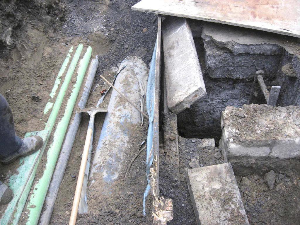
5 Other functions of a road As roads are public spaces, they carry water, gas, electricity, foul and surface sewers, telecom and fibre networks. These services in Dublin are underground, and various telecoms and service legislation provide for access to service, repair, improve or replace. Implications: Maintenance (short term settlement), Traffic (access can require road closure), Cost of repair, service relocation, Visual amenity wounds. Co-ordination of finance across organisations means that when works are being undertaken, upgrade costs are rarely available.
6

7
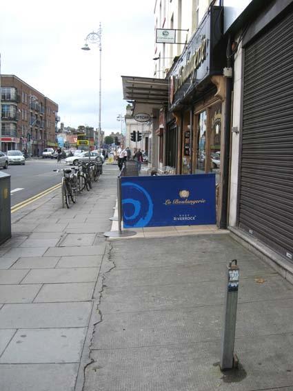
8
9 Right-of-Way versus Private Property Access must be provided to private property. Legal precedent exists to provide for car access across footpaths to private landings to park. The private space can be used by the owner even though there is a public right of way on it. Private landings often have cellars under them. The structural responsibility for the cellar is the owner s, unless it is damaged in construction of the surface space. Section 35 of the Public Health Acts Amendment Act 1890, deals with cellars. Rights of adjoining owners covered by Dublin Corporation Act 1890.
10
11
12

13 Dangers to public spaces. Areas without overlooking or sufficient passing traffic, can develop antisocial occupants. The vistas should be long, and should not have hidden areas. There should be uses in the space that will generate foot traffic throughout the entire day. The space should be well lit, and part of a pedestrian network.

14 Space at South King Street. Limestone seating blocks had to be removed due to late night anti social gathering. Space now works well but the seating is a loss Drainage of space presented problems due to shop floors at same level as street. No vehicular traffic.

15 Suffolk Street Space has defined carriageway, low speeds, user definition Pedestrians can use the roadway as their space Use of the space varies with the time of day, tourist buses, loading, car park exit, pedestrian link, contraflow cycle lane, information panel for tourist office.
16 Pedestrians (people per minute per metre width) Stadium egress,109 people per minute (ppm). At 1 per 2 secs and 1.2m width: 1500pph or 25ppm. prexmas Grafton/Henry St levels. At 900 pph or 15 ppm, crowding beginning to control speed and direction. At pph or 8ppm the street is still busy, all speeds possible, good level of service. At 250 pph or 4 ppm street is almost empty. Lower figures adapted from Great Streets by Allan B. Jacobs, MIT Press and confirmed by observation.

17 Talbot Street Pedestrian numbers on street approx. 3,000/hr or 50 per minute. Path width 7.0metres so 7 ppm Street layout offers clear carriageway definition for people with mobility impairment, has entry treatment for speed control, and servicing areas
18 Accident analysis (Dublin City Council ) Vulnerable road users(m/cyclists, cyclists, pedestrians) account for 83% of all fatalities and 53% all injuries. About 70% of pedestrian killed were over 50. Over half of these were over % killed were in collision with HGV or Bus. Over 75% of cyclists killed were in collision with HGV or Bus, many involved vehicle making left turn. Pedestrian fatality rate did not differ between the city centre and outside the canals Driver error was a contributory factor in 88% of collisions.
19 Street Environment The uses along the street generate activity. Design from viewpoint of trader, pedestrian, cyclist, motorist, resident, worker, visitor, children and retired people. Design is multi-disciplined. Should compliment uses. Planning should inform the level of movement on the street Retail, commercial, residential, part of larger route. Architecture should marry the function and form, locate sunny parks, provide vistas and a sense of scale and place, provide overlooking. Landscape architecture softens and gives a texture to the street, should compliment desire lines, contours etc. Engineering should provide the function, allocate space, services, maintenance, manage the movement of people and goods. Security, recognition level lighting, overlooking from windows or balconies, 18 hour shops, restaurants. Manage different times of day.
20 Necessary movement Loading/ servicing. Can it take place behind or from side street. It can double as parking after 7.00pm. Share loading bays, establish demand levels with beat surveys. Parking. Nearest spaces (owners) time control. Groups of spaces and a circuit. Both these activities can be used (carefully) to manage through traffic speeds. The most important movement is pedestrian. The economy of all towns depend on doing business with a pedestrian. The residential amenity, and your memory of a town is largely determined by the pedestrian environment of the streets.
21 Dublin City Centre Context

22 Mode Share (people) Extract from City Centre Transportation Plan

23 Movement indicators
24 Current Zoned Potential All figures based on EXISTING zoning in the current Dublin City Development Plan Residents to increase from 116,000 to about 170,000 Students to increase from 45,000 to 70,000 Employment to increase from 235,000 to 350,000 Retail floor space to increase from 640,000 sq. metres to 760,000 sq. metres (18% increase).
25 Implications for access Commuting access for education and employment currently generates 200,000 trips from a potential 275,000 to the city centre each morning. 73% of total enter the city each morning. New total rises from 275,000 to 420,000. New peak commuting hour rises from 200,000 to 306,000. An overall 50% increase in commuter numbers can not be accommodated by private car.

26 Travel Patterns outside the city Shows % of workers who drive over 20 miles to work. Transport for Dublin needs to provide alternative for these areas

27 Transport 21 Interconnector/ Dart underground Kildare 4 track Metro Luas Bx / D Double length of QBC network for 60% passenger increase Interchange

28 Cycling Royal and Grand Canal routes. S 2 S Linkage. Non arterial cycle priority, 20 km/hr. Potential cyclists (less than 5km) over 35%. Safety prime deterrent.

29 Central No Through Traffic (Access only) Zone Traffic restricted primarily to car park access inside Inner Distributor. St Stephen s Green, Merrion Square, Trinity College, Parnell Square, Mountjoy Square, and Fitzwilliam Square are all on or inside this zone.
30 Georgian Squares: Civic Trust, Defining Dublin s Historic Core Very close relation between 30 Km/h zone, Central no through traffic zone, and, the city centre as defined by the Georgian Squares.
31 Pedestrian movement and spaces

32 The Liffey as a civic and pedestrian Spine (1)

33 The Liffey as a civic and pedestrian Spine (2) Potential to extend boardwalk from Capel St to Croppy s acre Potential to develop riverside space in Heuston Quarter Incorporate Liffey into mental map of Dublin s open space and pedestrian network
34 Conclusions Shared space is difficult to achieve. Utility access for repair (upgrade) should be designed in as part of the cost. Legislation is aligned with separation of modes. MID facilities don t lie easily with the concept. The Public Realm needs a supply of people to be successful.
TRANSPORT AND MOVEMENT
 TRANSPORT AND MOVEMENT Movement Strategy Public Transport Cycling and Walking Road Network Parking Standards Transport Impact Assessments Traffic Management Policies DRAFT POOLBEG PLANNING SCHEME Movement
INDEX. Geometric Design Guide for Canadian Roads INDEX
 Acceleration lane, see Lanes, Acceleration Access, 8.1 Access Management and Functional Classification 8.2 Access Management by Design Classification 8.3 Access Configuration 8.4 Building Set-Back Guidelines
IAN WHITE ASSOCIATES. Crawley Station Gateway Public Realm
 IAN WHITE ASSOCIATES Crawley Station Gateway Public Realm contents 1. objectives & client brief 2. site appraisal 3. best practice guidance 4. design concept 1. objectives & client brief Crawley Train
C.A.R.S. Project Design Report.
 C.A.R.S. Project Design Report. PRODUCED BY: Browne, A. Kennedy, M. Dolan, N. Selman, C. STUDENT NO: DATE DUE: COURSE: LECTURER: C09365788-C09686908-D11125480-C08868352 20-April-2012 Dt004/3 Civil Engineering
Speed Limits in the Hoddle Grid
 Speed Limits in the Hoddle Grid Recent History of speed limits March 2013 Docs # 7738485 1 Introduction Muncipalities have power to Erect speed limit signs BUT Municipalities DO NOT have the power to approve
DESIGN CODE. Enterprise West Harlow London Road North Design Code 21
 DESIGN CODE Enterprise West Essex @ Harlow London Road North Design Code 21 4 MAXIMUM BUILDING HEIGHTS 4.1 Table 4A sets out maximum building height standards for each character area within the LDO boundary.
Submission on Clontarf to City Centre Cycle Route with signatures of 1,493 people
 Submission on Clontarf to City Centre Cycle Route with signatures of 1,493 people Route should use a fully segregated two-way cycle path Contact details Cian Ginty - editor, IrishCycle.com - cian.ginty@gmail.com
High frequency bus services operating to Little Island; Creation of a new Park and Ride site and train station at North Esk;
 Cork County Council 7 th December 2018 Dear Adrian O Neill (aoneill@jbbarry.ie) The Transport and Mobility Forum, Cork (TMF) is a representative group of organisations who have a common interest in sustainable
Economic and Social Council
 UNITED NATIONS E Economic and Social Council Distr. GENERAL 20 December 2006 ENGLISH Original: ENGLISH and FRENCH ECONOMIC COMMISSION FOR EUROPE INLAND TRANSPORT COMMITTEE Working Party on Road Traffic
Frascati Road and Temple Hill Route Improvements. Outline Design Report to Accompany Public consultation
 Frascati Road and Temple Hill Route Improvements Outline Design Report to Accompany Public consultation September 2013 Background: Dún Laoghaire-Rathdown is committed to providing high quality pedestrian
The Cabinet Member for Highways & Streetscene. Aurang Zeb - Head of Highways & Transport
 LONDON BOROUGH OF RICHMOND UPON THAMES Cabinet Member Decision DATE: January 2012 REPORT OF: LEAD OFFICER: SUBJECT: WARDS: The Cabinet Member for Highways & Streetscene Aurang Zeb - Head of Highways &
College Green Submission May 2016 Executive Summary
 College Green Submission May 2016 Executive Summary The advent of the Luas Cross City in 2017 will bring major changes to Dublin city. The city s central spine which will now be used by Luas, has for many
Classification Criteria
 SCHEDULE D TO RECOMMENDED OFFICIAL PLAN AMENDMENT NO. 40 SCHEDULE C-4 Road Criteria Criteria Traffic Service Objective Land Service/Access Typical Daily Traffic Volume Flow characteristics Travel Speed
CITY OF OTTAWA ROADWAY MODIFICATION APPROVAL UNDER DELEGATED AUTHORITY
 RMA-2015-ATM-038 CITY OF OTTAWA ROADWAY MODIFICATION APPROVAL UNDER DELEGATED AUTHORITY DATE: April 22, 2015 SUBJECT Approval of Roadway Modifications Recommended through an Area Traffic Management Study
Tonight is for you. Learn everything you can. Share all your ideas.
 Strathcona Neighbourhood Renewal Draft Concept Design Tonight is for you. Learn everything you can. Share all your ideas. What is Neighbourhood Renewal? Creating a design with you for your neighbourhood.
LEA BRIDGE ROAD - A STREET FOR EVERYONE Public consultation document
 LEA BRIDGE ROAD - A STREET FOR EVERYONE Public consultation document TELL US Bakers Arms to Leyton Green Road (Section D, E, F) Leyton Green Road to Whipps Cross Roundabout (Section G) YOUR VIEWS www.enjoywalthamforest.co.uk
2017 Temporary traffic control guidelines for pedestrians. v.2
 2017 Temporary traffic control guidelines for pedestrians v.2 Temporary Traffic Control Guidelines for Pedestrians (2017) The safety and mobility of pedestrians, cyclists and motorists must be considered
Alternatives to the Use of Heritage Squares for Bus Layover in Dublin City Centre
 Presentation to DCC Public Transport Sub-committee Dublin City Hall, 11 th March 2016 Alternatives to the Use of Heritage Squares for Bus Layover in Dublin City Centre A DIT Community Links Project on
Dún Laoghaire Rathdown County Council. Luas to Dart via UCD Cycle and Pedestrian Route
 Dún Laoghaire Rathdown County Council Luas to Dart via UCD Cycle and Pedestrian Route October 2012 Luas to Dart via UCD Cycle and Pedestrian Route DOCUMENT CONTROL SHEET Client: Project Title: Document
Southside Road. Prepared for: City of St. John s Police & Traffic Committee. Prepared by: City of St. John s Traffic Division
 Southside Road Prepared for: City of St. John s Police & Traffic Committee Prepared by: City of St. John s Traffic Division January 2007 Southside Road - Traffic Report Page 1 of 9 BACKGROUND: th At the
Creating walkable, bikeable and transit-supportive communities in Halton
 Creating walkable, bikeable and transit-supportive communities in Halton By presenting current research and best practices, the information in this paper is meant to support and broaden discussion on how
Wicklow County Council Chomairle Chontae Chill Mhantáin. Traffic Calming Policy
 Chomairle Chontae Chill Mhantáin Adopted by Wicklow County Council on the 11th of June, 2012 Contents Section Page 1. Introduction 3 2. Legislation 3 3. Guidance Documentation 3 4. Policy Objectives &
How do we design for pedestrians? Case study: transforming the Walworth Road
 How do we design for pedestrians? Case study: transforming the Walworth Road David Moores, Director of Public Realm Institution of Highways and Transportation, November 2009 Presentation overview Design
Dr. Naveed Anwar Executive Director, AIT Consulting Affiliated Faculty, Structural Engineering Director, ACECOMS
 Dr. Naveed Anwar Executive Director, AIT Consulting Affiliated Faculty, Structural Engineering Director, ACECOMS Overview Highway Functions and Classifications Highway Design Components Design Control
TRANSPORTATION & MOBILITY
 TRANSPORTATION & MOBILITY ROADWAY SYSTEM There are approximately 40 miles of roadways in Manitou Springs. For planning purposes, roadways are typically assigned a functional classification which defines
BETHEL ROAD AND SEDGWICK ROAD CORRIDOR STUDY
 DRAFT PLAN City Council Meeting August 14, 2017 STUDY AREA Sedgwick Corridor State Route 160, principal arterial with Class 3 access management designation, commuter and freight route, connection to SR
Process for managing parking on verges, footways and footpaths
 Process for managing parking on verges, footways and footpaths Author: MG/NR Highways and Transport Environment Department Date: 28 July 2015 Version: 2.0 PARKING ON VERGES, FOOTWAYS AND FOOTPATHS Introduction
AUTOMATED AND ZERO EMISSION VEHICLES HOW THEY MIGHT RESHAPE OUR STREETS
 AUTOMATED AND ZERO EMISSION VEHICLES HOW THEY MIGHT RESHAPE OUR STREETS BACKGROUND: This study is a collaboration between Urban Circus (Visualisation) and Ethos Urban (Urban Design) Ideas were workshopped
(HIGHWAY GEOMETRIC DESIGN -1)
") LECTURE HOUR-19 TE-1(10CV56) UNIT-3 (HIGHWAY GEOMETRIC DESIGN -1) Width of carriage way: Width of the carriage way or the width of the pavement depends on the width of the traffic lane and number of lanes.
LECTURE HOUR-19 TE-1(10CV56) UNIT-3 (HIGHWAY GEOMETRIC DESIGN -1) Width of carriage way: Width of the carriage way or the width of the pavement depends on the width of the traffic lane and number of lanes.
Sandyford Cycle Route (Kilgobbin / Drummartin Link Road)
") Sandyford Cycle Route (Kilgobbin / Drummartin Link Road) Public Consultation Report on Submissions Client: Dun Laoghaire-Rathdown County Council Date: May 2018 Job Number: 15_116B Clifton Scannell Emerson
Sandyford Cycle Route (Kilgobbin / Drummartin Link Road) Public Consultation Report on Submissions Client: Dun Laoghaire-Rathdown County Council Date: May 2018 Job Number: 15_116B Clifton Scannell Emerson
Strategy for Walking & Cycling Action Plan
 Strategy for Walking & Cycling Action Plan To achieve higher levels of walking and cycling activity, the destinations which people access have to be available within suitable distances and designed to
IMPLEMENTATION. PEDESTRIAN USERS (Continued /) Building Frontages: A: Stair Applications. Geometry (Accessed from the Sidewalk) Refer to A:
 Building Frontages: A: Stair Applications. Geometry (Accessed from the Sidewalk) Refer to A:") A: Stair Applications Building Frontages: Geometry (Accessed from the Sidewalk) Refer to A: Ramps should be provided for disabled users at 1:12 (8.3%) gradient. Ramp rises should be stepped at 400mm intervals.
A: Stair Applications Building Frontages: Geometry (Accessed from the Sidewalk) Refer to A: Ramps should be provided for disabled users at 1:12 (8.3%) gradient. Ramp rises should be stepped at 400mm intervals.
2. Context. Existing framework. The context. The challenge. Transport Strategy
 Transport Strategy Providing quality connections Contents 1. Introduction 2. Context 3. Long-term direction 4. Three-year priorities 5. Strategy tree Wellington City Council July 2006 1. Introduction Wellington
Pattullo Bridge Replacement Project Community Connections Phase 2 Consultation. Appendix 3: Open House Display Boards
 Replacement Project Community Connections Phase 2 Consultation Appendix 3: Open House Display Boards November 2016 Welcome! Welcome to the Replacement Project Public Open House We Want to Hear from You
Urban Street Design with DMURS. Sean McGrath Senior Executive Engineer Fingal County Council
 Urban Street Design with DMURS Sean McGrath Senior Executive Engineer Fingal County Council Urban versus Rural Design Rural Road Design Prefer higher speed Release constraints Work within fence line Urban
Corpus Christi Metropolitan Transportation Plan Fiscal Year Introduction:
 Introduction: The Safe, Accountable, Flexible, Efficient Transportation Equity Act: A Legacy for Users (SAFETEA-LU) has continued the efforts started through the Intermodal Surface Transportation Efficiency
4.1 Introduction. 4.2 Aspects of walkable communities
 4 Community walkability Community walkability Making communities walkable Urban form Feeling secure 4.1 Introduction Walkability describes the extent to which the built environment is walking-friendly.
CHECKLIST 2: PRELIMINARY DESIGN STAGE AUDIT
 CHECKLIST 2: PRELIMINARY DESIGN STAGE AUDIT 2.1 General topics 2.1.1 Changes since previous audit Do the conditions for which the scheme was originally designed still apply? (for example, no changes to
Improving Public Spaces in Chennai
 Improving Public Spaces in Chennai Pedestrian Facilities and Pedestrianisation 3 September 2013 Mr Nandakumar Mr Nandakumar Executive Engineer Corporation of Chennai Maintenance and Status The Hon ble
Roadway Classification Design Standards and Policies. Pueblo, Colorado November, 2004
 Roadway Classification Design Standards and Policies Pueblo, Colorado November, 2004 Table of Contents Page Chapter 1. General Provisions 1.1 Jurisdiction 3 1.2 Purpose and Intent 3 1.3 Modification 3
Background. Caversham a vision for the future. Joint public meeting arranged by:
 Joint public meeting arranged by: Sharing our Streets Caversham a vision for the future and Caversham Traders Association This presentation followed a presentation by Simon Beasley, Network Manager for
Cabinet Member for Highways & Streetscene. Highway Infrastructure Manager
 LONDON BOROUGH OF RICHMOND UPON THAMES DATE: AUGUST 2015 DECISION MAKER: LEAD OFFICER: SUBJECT: WARDS: Cabinet Member for Highways & Streetscene Highway Infrastructure Manager PROPOSED CYCLING IMPROVEMENTS
Exhibit 1 PLANNING COMMISSION AGENDA ITEM
 Exhibit 1 PLANNING COMMISSION AGENDA ITEM Project Name: Grand Junction Circulation Plan Grand Junction Complete Streets Policy Applicant: City of Grand Junction Representative: David Thornton Address:
Ballston Station Multimodal Study WMATA and Arlington County. Meeting Minutes
 Date of Meeting: June 10, 2010 Location: Ballston Metrorail Station and NRECA Building 4301 Wilson Blvd, Arlington, VA Subject: Ballston Station Multimodal Study Stakeholder Meeting #1 Summary: This first
CITY OF VAUGHAN EXTRACT FROM COUNCIL MEETING MINUTES OF OCTOBER 30, 2012
 CITY OF VAUGHAN EXTRACT FROM COUNCIL MEETING MINUTES OF OCTOBER 30, 2012 Item 31, Report No. 39, of the Committee of the Whole, which was adopted without amendment by the Council of the City of Vaughan
2.0 LANE WIDTHS GUIDELINE
 2.0 LANE WIDTHS GUIDELINE Road Engineering Design Guidelines Version 2.0.1 May 2018 City of Toronto, Transportation Services City of Toronto Page 0 Background In early 2014, Transportation Services initiated
TRAVEL PLAN: CENTRAL EUROPEAN UNIVERSITY CAMPUS REDEVELOPMENT PROJECT TRAVEL PLAN. Central European University Campus Redevelopment Project.
 TRAVEL PLAN Central European University Campus Redevelopment Project Page 1 Table of Contents Introduction... 3 Background... 7 Building Users... 7 Transportation in Community Consultation... 7 Summary
AUTOMATED AND ZERO EMISSION VEHICLES HOW THEY MIGHT RESHAPE OUR STREETS
 AUTOMATED AND ZERO EMISSION VEHICLES HOW THEY MIGHT RESHAPE OUR STREETS STURT ST BALLARAT WATERGARDENS TAYLORS LAKES SIMPSON ST YARRAVILLE CHAPEL ST SOUTH YARRA RINGWOOD STATION MONASH FREEWAY SA NSW VIC
Appendix A Type of Traffic Calming Measures Engineering Solutions
 Appendix A Type of Traffic Calming Measures Engineering Solutions PHYSICAL MEASURES Central Hatching The major consideration of this feature is that, these markings can only be laid down the centre of
HISTON ROAD Have your say on better public transport, cycling and walking journeys
 HISTON ROAD Have your say on better public transport, cycling and walking journeys Have your say: Please complete the survey inside this leaflet or online at www.greatercambridge.org.uk/histonconsultation
Douglas Land Use and Transportation Strategy (DLUTS) Summary. August 2013
 Summary. August 2013") Douglas Land Use and Transportation Strategy (DLUTS) Summary August 2013 Background Douglas is a large and popular residential suburb of approximately 30,000 persons on the periphery of Cork City along
Douglas Land Use and Transportation Strategy (DLUTS) Summary August 2013 Background Douglas is a large and popular residential suburb of approximately 30,000 persons on the periphery of Cork City along
CITY OF BLOOMINGTON COMPLETE STREETS POLICY
 CITY OF BLOOMINGTON COMPLETE STREETS POLICY POLICY OBJECTIVE: The City of Bloomington will enhance safety, mobility, accessibility and convenience for transportation network users of all ages and abilities,
Appendix T CCMP TRAIL TRAFFIC & TRANSPORTATION DESIGN STANDARD
 Appendix T CCMP 3.3.4 TRAIL TRAFFIC & TRANSPORTATION DESIGN STANDARD 3.3.4 Trail Traffic and Transportation Design Multi-use trails have certain design standards, which vary depending on the agency that
CHAPTER 16 PEDESTRIAN FACILITIES DESIGN AND TECHNICAL CRITERIA TABLE OF CONTENTS
 CHAPTER 16 PEDESTRIAN FACILITIES DESIGN AND TECHNICAL CRITERIA TABLE OF CONTENTS Section Title Page 16.1 General... 16-1 16.1.1 AASHTO Reference... 16-1 16.1.2 ADA Requirements... 16-1 16.2 Sidewalks...
Chapter 4: Jyllinge-Sallingvej
 Chapter 4: Jyllinge-Sallingvej 4.1 Case Context and Existing Situation 4.1.1 Case Study Area and Character Sections Placement and direction of photos see Appendix 1, where also house numbers and street
Pedestrians safety. ROAD SAFETY SEMINAR PIARC/AGEPAR/GRSP Lome, Togo October 2006 Lise Fournier, Canada-Qu
 Pedestrians safety ROAD SAFETY SEMINAR Lome, Togo October 2006 Lise Fournier, Canada-Qu Québec Contents WHO s data Risk factors Pedestrian needs Pedestrian facilities Conclusion Source: WHO WHO reports
Road Safety Facilities Implemented in Japan
 Road Safety Facilities Implemented in Japan 1 Road Safety Facilities 1.Guard Fence 2.Road Lighting 3.Other Road Safety Facilities 2 Road Safety Facilities 1.Guard Fence 2.Road Lighting 3.Other Road Safety
Integrated Regional Traffic Management. Michael Aherne Technical Director POLIS Conference 2009
 Integrated Regional Traffic Management Michael Aherne Technical Director POLIS Conference 2009 M50 finish Public Transport and Pedestrians College Green The Spatial Perspective What Could has
ECONOMY PEOPLE ENVIRONMENT
 Report Back on Local Transit Improvements May 29, 2013 ECONOMY PEOPLE ENVIRONMENT Intro Council Requested Report Back Topics Progress on Planning for Broadway Subway False Creek Bridges Local Transit Improvements
Dublin City Cycle Scheme
 Dublin City Cycle Scheme Phase 3: Potential Locations Oct. 2008 PLANNING & ROADS CYCLE WORKING GROUP ROB FENNELLY JAMES CAHILL ALL LOCATIONS ARE INDICATIVELY SHOWN. ALL SITES ARE SUBJECT TO SERVICES INVESTIGATION.
Terwillegar Drive Expressway Draft Concept Plan
 Terwillegar Drive Expressway Draft Concept Plan Anthony Henday Drive to Whitemud Drive November 28 5:00-8:00 p.m. December 1 10:00 a.m. - 3:00 p.m. Let s Talk Today you can: Learn about the new direction
NJDOT Complete Streets Checklist
 Background The New Jersey Department of Transportation s Complete Streets Policy promotes a comprehensive, integrated, connected multi-modal network by providing connections to bicycling and walking trip
Governance and Priorities Committee Report For the July 2, 2015 Meeting
 CITY OF VICTORIA For the July 2, 2015 Meeting To: Governance and Priorities Committee Date: From: Subject: Brad Dellebuur, A/Assistant Director, Transportation and Parking Services Executive Summary The
College Green traffic management changes
 College Green traffic management changes No through east-west traffic movements in the College Green area except for pedestrians and cyclists. Two-way bus and tram movements on Lower Grafton Street and
EXECUTIVE SUMMARY Callan Park accommodates travel from a wide range of transport modes, including walking, cycling, bus and light rail.
 TRANSPORT AND ACCESS EXECUTIVE SUMMARY Callan Park accommodates travel from a wide range of transport modes, including walking, cycling, bus and light rail. Whilst there are some walking facilities within
RZC Appendix 8A Marymoor Subarea Street Requirements
 RZC Appendix 8A Marymoor Subarea Street Requirements For additional design details for Marymoor Subarea infrastructure, refer to the 2017 Marymoor Subarea Infrastructure Planning Report. STREET REQUIREMENTS
Your views are important. Please fill in a form before you leave. Or alternatively
 Drum Property Group is delighted to welcome you to this exhibition which sets out our initial proposals for a mixed-use development at Stead s Place, Edinburgh. We are keen to hear the views of local people
5. RUNNINGWAY GUIDELINES
 5. RUNNINGWAY GUIDELINES These guidelines should be considered collectively when making runningway decisions. A runningway is the linear component of the transit system that forms the right-of-way reserved
Appendix 12 Parking on footways and verges
 Appendix 12 Parking on footways and verges Legal position Parking on footways and verges whether wholly or partly is banned throughout London, unless signs are placed to allow parking. The ban requires
7/23/2017 VIA . Michael Hanebutt City of Sacramento Community Development Department 300 Richards Boulevard, 3 rd Floor Sacramento, CA 95811
 7/23/2017 VIA EMAIL Michael Hanebutt City of Sacramento Community Development Department 300 Richards Boulevard, 3 rd Floor Sacramento, CA 95811 RE: 65 th Street Apartments (DR17-220) Dear Mr. Hanebutt:
IMPLEMENTATION. PEDESTRIAN USERS (Continued /) A: Class 2 Pedestrian / Cycle Ways. Pedestrian and Cycle Ways:
 A: Class 2 Pedestrian / Cycle Ways. Pedestrian and Cycle Ways:") A: Class 2 Pedestrian / Cycle Ways PLAN VIEW Pedestrian and Cycle Ways: Layout and Geometry (Refer to A): Walkways and cycle to be provided adjacent to all Class 2 Roads (these facilities should always
A: Class 2 Pedestrian / Cycle Ways PLAN VIEW Pedestrian and Cycle Ways: Layout and Geometry (Refer to A): Walkways and cycle to be provided adjacent to all Class 2 Roads (these facilities should always
Part VII Application For Revised South Side Traffic Management Works To Facilitate Luas BXD
 Dublin Cycling Campaign P.O. Box 10295, Dublin 3. Email info@dublincycling.ie www.dublincycling.ie Executive Manager, Planning Department, Dublin City Council, Civic Offices, Wood Quay, Dublin 8 4 February
5. PLASTIRA STREET Case Study Area and Character Sections. Marina. Case Study Area. Character Sections. National Report of Greece
 Plastira 5. PLASTIRA STREET 5.1. Case Study Area and Character Sections Case Study Area Plastira street is located in the Eastern part of the city of Kalamaria and it is a significant two-way arterial
PEDESTRIAN ACTION PLAN
 ATTACHMENT 2 CITY OF SANTA MONICA PEDESTRIAN ACTION PLAN CITY OF SANTA MONICA PEDESTRIAN ACTION PLAN This page intentionally left blank EXECUTIVE SUMMARY CHAPTER 1 EXECUTIVE SUMMARY Setting the Stage
Fitting Light Rail through Well-established Communities
 Fitting Light Rail through Well-established Communities San Francisco 2008 Michael D. Madden Chief, Project Development, Maryland Transit Administration Project Setting Located inside the Capital Beltway
DRAFT for a State Policy for Healthy Spaces and Places
 DRAFT for a State Policy for Healthy Spaces and Places 1 DRAFT State Policy for Healthy spaces and Places 1. Purpose To encourage the use and development of land that builds healthy communities through
Limerick City & County Council Traffic Calming Policy for Urban Areas DRAFT
 Limerick City & County Council Traffic Calming Policy for Urban Areas DRAFT Physical Development Directorate February 2018 Traffic Calming in Limerick City Minister Donohue launches 30kph Slow Zone Sign
Chapter 4 Route Window C3 Hyde Park and Park Lane shafts. Transport for London
 Chapter 4 Route Window C3 Hyde Park and Park Lane shafts Transport for London HYDE PARK AND PARK LANE SHAFTS 4 Route Window C3 Hyde Park and Park Lane shafts Introduction 4.1 In this route window, which
College Green Road Re-alignment Scheme Report to South East Area Committee Proposed Part VIII Application
 College Green Road Re-alignment Scheme Report to South East Area Committee Proposed Part VIII Application Christopher Manzira, Senior Executive Engineer Roads & Traffic Planning Environment and Transportation
Aurora Urban Street Standards For Transit Oriented Developments and Urban Centers
 Aurora Urban Street Standards For Transit Oriented Developments and Urban Centers I. Purpose These standards will be applied to create a safe, comfortable, pleasant and pedestrian-friendly multi-modal
Public Consultation on Braintree Integrated Transport Package (ITP) HAVE YOUR. Consultation open from 24 September to 5 November 2018 SAY
 HAVE YOUR. Consultation open from 24 September to 5 November 2018 SAY") Public Consultation on Braintree Integrated Transport Package (ITP) HAVE YOUR SAY Consultation open from 24 September to 5 November 2018 Contents Introduction 3 Background 4 Springwood Drive Roundabout
Public Consultation on Braintree Integrated Transport Package (ITP) HAVE YOUR SAY Consultation open from 24 September to 5 November 2018 Contents Introduction 3 Background 4 Springwood Drive Roundabout
6. BREENS/GARDINERS/HAREWOOD INTERSECTION - SAFETY IMPROVEMENT PROJECT
 6. BREENS/GARDINERS/HAREWOOD INTERSECTION - SAFETY IMPROVEMENT PROJECT General Manager responsible: Officer responsible: Author: Jane Parfitt General Manager City Environment DDI 941 8656 Michael Aitken
Proposed Bridge Street East Bicycle Lanes Public Open House Thursday, April 27, 2017
 WELCOME Proposed Bridge Street East Bicycle Lanes Public Open House Thursday, April 27, 2017 Purpose of the Open House The purpose of this Open House is to gain public input on the bicycle lanes proposed
Design of Stanley Park S-Curve
 ADMINISTRATIVE REPORT Date: May 4, 2001 TO: FROM: Author/Local: F. Klotzbach/7118 RTS NO. 01644 CC File No. Standing Committee on Transportation and Traffic General Manager of Engineering Services, in
BELFAST ON THE MOVE Transport Masterplan for Belfast City Centre
 BELFAST ON THE MOVE Transport Masterplan for Belfast City Centre CIHT Technical Evening 23 February 2015 Ciarán de Búrca, Director Transport Projects Division Civic Spine Background Belfast Metropolitan
National Cycle Network Funding Scheme 2012/2012 Application Form. Waterford City Council. Paul Cleary, Executive Engineer. 3.2km 289, ,000
 National Cycle Network Funding Scheme 2012/2012 Application Form Section 1:Project Outline Name and Address of Local Authority Contact person/proposed project manager Waterford City Council Paul Cleary,
3. INTERCONNECTED STREETS AND TRANSPORTATION NETWORKS
 Design Approaches 61 3. INTERCONNECTED STREETS AND TRANSPORTATION NETWORKS There are a number of different approaches to interconnect streets in neighborhoods and Development Areas. Interconnections provide
Figure 4-10: Pedestrian Improvements Types of Potential Station Area Improvements - Place-Making Improvements
 INCORPORATE FEATURE PAVIN IN CROSSWALK AND INTERSECTION FIELDS Identifies high-priority pedestrian areas and create a station identity through colorful and interesting patterns ADD CURB EXTENSIONS Extending
March Maidstone Integrated Transport Strategy Boxley Parish Council Briefing Note. Context. Author: Parish Clerk 2 March 2016
 Context. Author: Parish Clerk 2 The Draft Integrated Transport Policy (DITS) sets out a vision and objectives, and identifies a detailed programme of interventions to support the Maidstone Borough Local
Design Criteria. Design Criteria
 F Design Criteria Design Criteria Ministry of Transportation Ministère des Transports DESIGN CRITERIA Page: 1 of 13 WORK PROJECT NO. N/A GO Bloomington Station TYPE OF PROJECT LOCATION Bloomington Road
City of Wayzata Comprehensive Plan 2030 Transportation Chapter: Appendix A
 A1. Functional Classification Table A-1 illustrates the Metropolitan Council s detailed criteria established for the functional classification of roadways within the Twin Cities Metropolitan Area. Table
A5.1 Permitted activities
 Section A5 Transportation A5.1 Permitted activities A5.1.1 Activities within roads Note: Refer to Section D for the definition of road (a) Any activity associated with the movement of traffic and the functioning
122 Avenue: 107 Street to Fort Road
 : 107 Street to Fort Road November 24, 2015 4:30 8:00 p.m. Meeting Purpose Summarize project work completed to date Share results of public input from Phase 1 Share the draft concept plan and proposed
HORN PROHIBITED NO PARKING NO STOPPING STRAIGHT PROHIBITED NO ENTRY
 UNIT III 1. What are the various types of traffic signs? [N/D-13] Traffic signs give timely warning of hazardous situations when they are not self - evident. The various types of traffic signs are: a)
TS 109 DURHAM ROAD QTC PHASE 4 PROJECT PROPOSAL. Page 1
 TS 109 DURHAM ROAD QTC PHASE 4 PROJECT PROPOSAL Page 1 Table of Contents 1.0 Introduction... 3 2.0 Project Overview... 3 3.0 Project Proposals... 4 3.1 Enfield Road / Durham Road Junction... 3 5 3.2 Summerfield
Amendments to Essex Highway Maintenance Strategy Maintenance Policy and Standards April 2008
 Amendments to Essex Highway Maintenance Strategy Maintenance Policy and Standards April 2008 The following amendments to the wording of the maintenance strategy apply following the revised maintenance
Guide to the Cycle Enfield Public Consultation on Enfield Town. Produced by the Save Our Enfield Town Campaign Group
 Guide to the Cycle Enfield Public Consultation on Enfield Town Produced by the Save Our Enfield Town Campaign Group What s in this guide? Introduction Page 3 What Enfield Council says about Option 1 Page
Tel: Karime Hassan Chief Executive Exeter City Council Civic Centre Paris Street Exeter EX1 1JN
 Page 1 of 6 Karime Hassan Chief Executive Exeter City Council Civic Centre Paris Street Exeter EX1 1JN Dear Mr Hassan 14th September 2015 Re: Development of Bus & Coach Station Site Following the submission
North West Non-Technical Summary of the Transport Assessment September 2011
 North West Non-Technical Summary of the Transport Assessment September 2011 Introduction This is a Non-Technical Summary of the findings of the Transport assessment work undertaken for the proposed North
ACTIVE TRANSPORTATION
 ACTIVE TRANSPORTATION Mobility 2040 Supported Goals Improve the availability of transportation options for people and goods. Support travel efficiency measures and system enhancements targeted at congestion