Urban Street Design with DMURS. Sean McGrath Senior Executive Engineer Fingal County Council
|
|
|
- Hugh Morton
- 6 years ago
- Views:
Transcription
1 Urban Street Design with DMURS Sean McGrath Senior Executive Engineer Fingal County Council
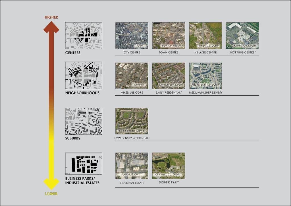
2 Urban versus Rural Design Rural Road Design Prefer higher speed Release constraints Work within fence line Urban Road and Street Design Prefer lower speeds - depends on place Allow (encourage?) constraints Work outside fence/kerb line (urban context)

3 March 2014
4

5 Speed and Design TRL (UK) reports 322, 325 and 551 Driver speed based on visual, psychological interpretation of the street. Legislation and regulation play a secondary role.


6 Speed and Urban Design DMURS analysed 9,500 RSA Free Speed Surveys and extent of hard and soft measures Glasilawn Road Abbey Park Delwood Road Lwr. Kilmacud Road (R825) Clonkeen Road (R827) Morehampton Road (N11) Navan Road (N3) Stillorgan Road (N11)


 Ave.")

7 Speed and Urban Design Speed is a function of Urban Design Stillorgan Road (60 km/h) Ave km/h Lwr Kilmacud Rd (50 km/h) Ave km/h Brian Rd (50 km/h) Ave km/h Frequency and Extent of Psychological and Physical Measures

8 Design and Low Speed
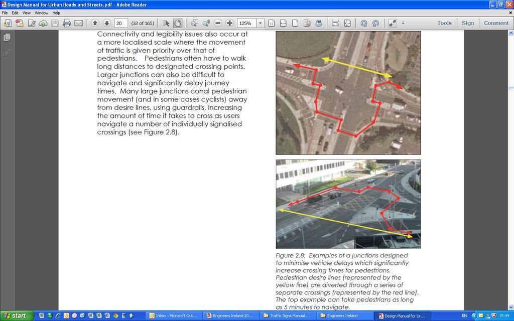
9 DMURS Practical Implications Street Networks (3.3.1) Filtered permeability Orthogonal (Fig 3.8) Curvilinear Organic


10 Using images or content with text Use a single clear image or graphic that illustrates your point Keep your points short and succinct Use bold for emphasis Dept. Name
11
12
13 Dublin in Comparison to Similar Cities Difference is mainly walking and cycling, not public transport 100% 90% 80% 70% 60% P ubl i c T r anspor t 50% Wal k/ Cycl e V ehi cl e 40% 30% 20% 10% 0% Dubl i n (1.2 A mster dam M uni ch (1.3 V i enna (1.6 Copenhagen M adr i d (3.2 mi l l i on) (0.8 mi l l i on) mi l l i on) mi l l i on) (1.9 mi l l i on) mi l l i on)
14 Cork in Comparison to Similar Cities Difference is mainly walking and cycling, not public transport 100% 90% 80% 70% 60% 50% 40% P ubl i c T r anspor t Wal k/ Cycl e V ehi cl e 30% 20% 10% 0% Cor k (0.2 Fr ei bur g Odense (0.19 San Gr az (0.26 Gr oni ngen M al mo (0.3 mi l l i on) (0.22 mi l l i on) Sebasti an mi l l i on) (0.18 mi l l i on) mi l l i on) (0.18 mi l l i on) mi l l i on)
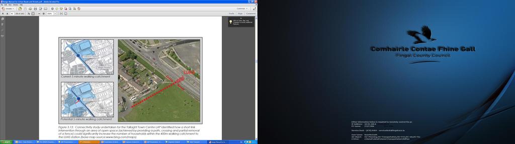
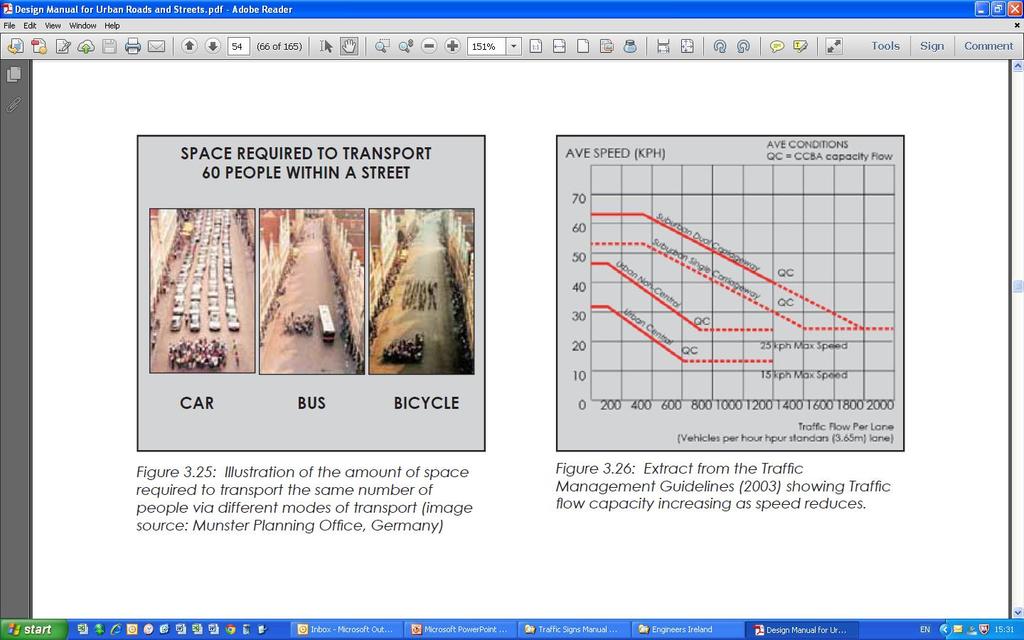
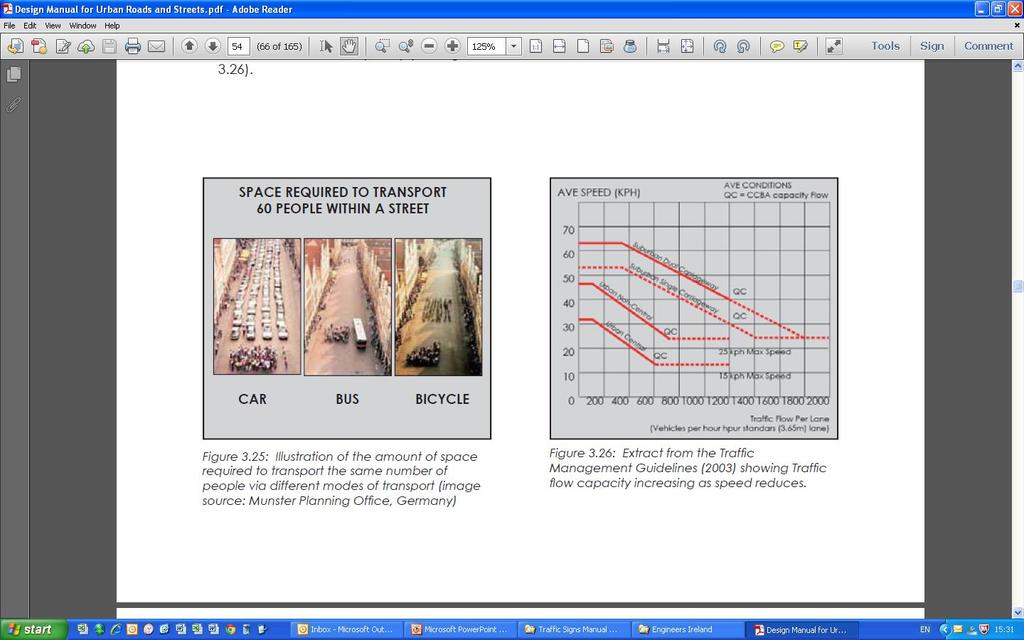
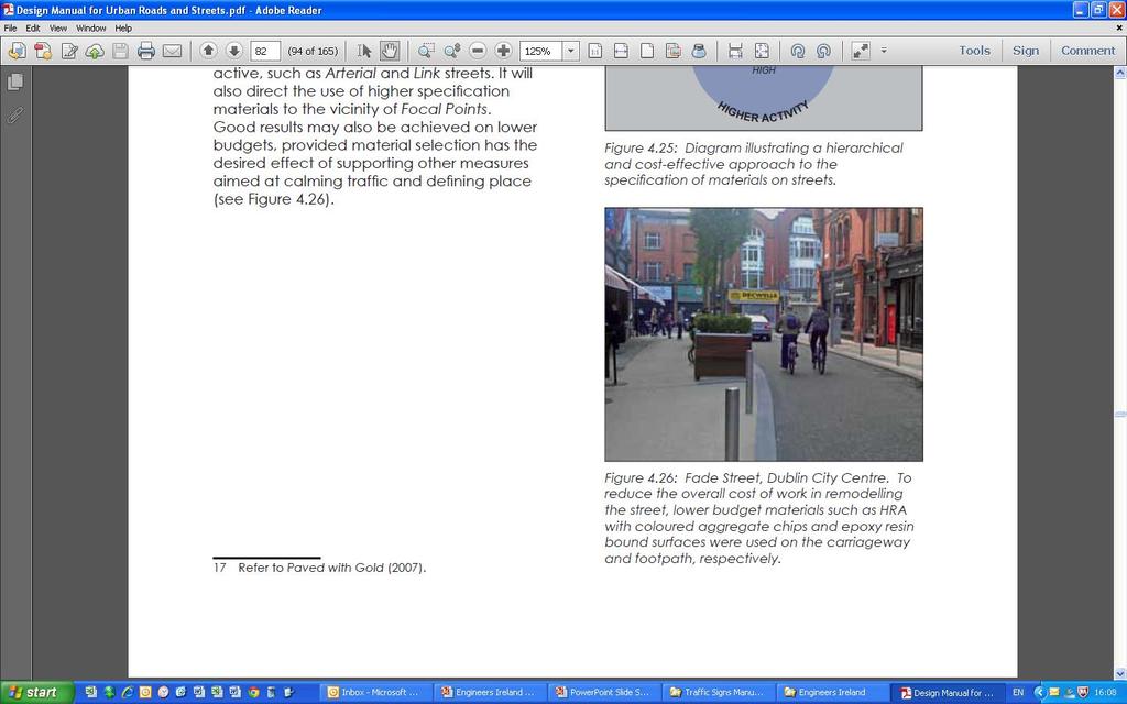
15 DMURS Practical Implications Traffic Congestion (3.4.2) No new roads in urban centres cost, environmental reasons Maximise efficient use of road space (Fig 3.25) Accept some level of congestion is inevitable
16
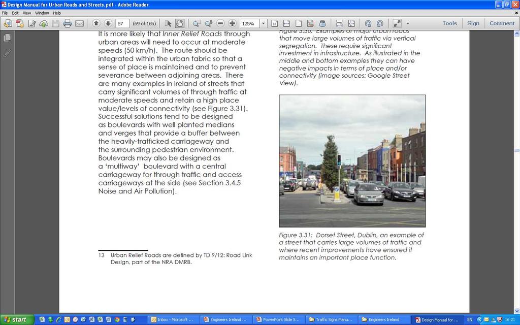
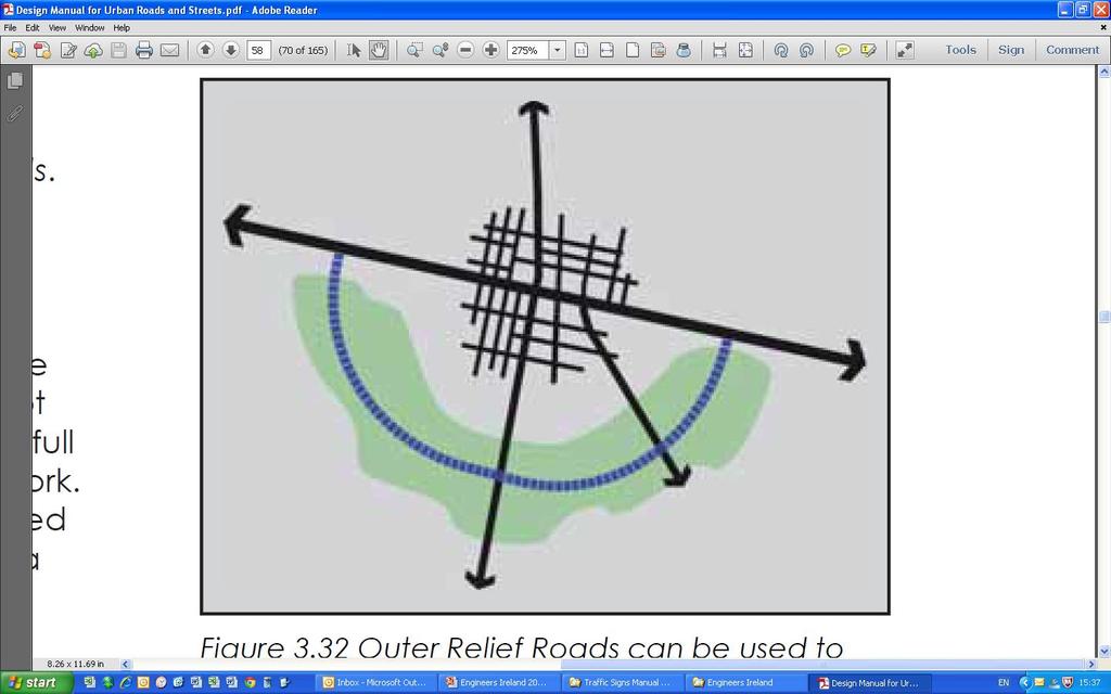
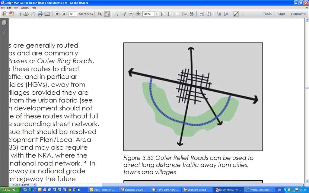
17 DMURS Practical Implications Relief Roads (3.4.4) High capacity, but not necessarily high speed Longer distance traffic, especially HGVs Take traffic away from urban centres Inner Relief Road (Fig 3.31) Maintain sense of place Minimise severance Outer Relief Road (Fig 3.32) Separate from urban area Strategically planned (SDZ, Local Area Plan)
18
19 DMURS Practical Implications Relief Roads (3.4.4) High capacity, but not necessarily high speed Longer distance traffic, especially HGVs Take traffic away from urban centres Inner Relief Road (Fig 3.31) Maintain sense of place Minimise severance Outer Relief Road (Fig 3.32) Separate from urban area Strategically planned (SDZ, Local Area Plan)
20
21 DMURS Practical Implications Signing and Lining (4.2.4) Traffic Signs Manual Advises against over-provision of signs (1.1.10) shall or must, should and may (1.1.12) Minimise signage, esp. on local streets Better to have self-regulating design

22 Local Transport Note 2/09 There is no conclusive evidence that the inclusion of PGR at any type of pedestrian crossing or junction has any statistically significant effect on safety
23 DMURS Practical Implications Materials and Finishes (4.2.6) Define space, calm traffic, and improve legibility Reduce the need for barriers, signing and lining Need not be expensive
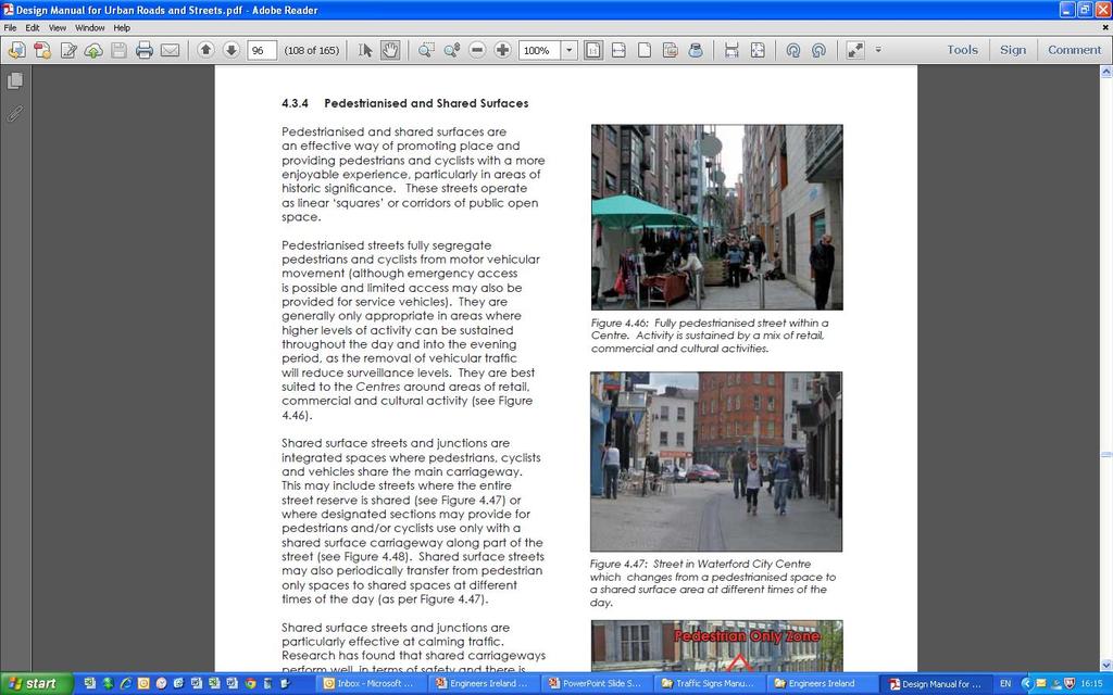
24
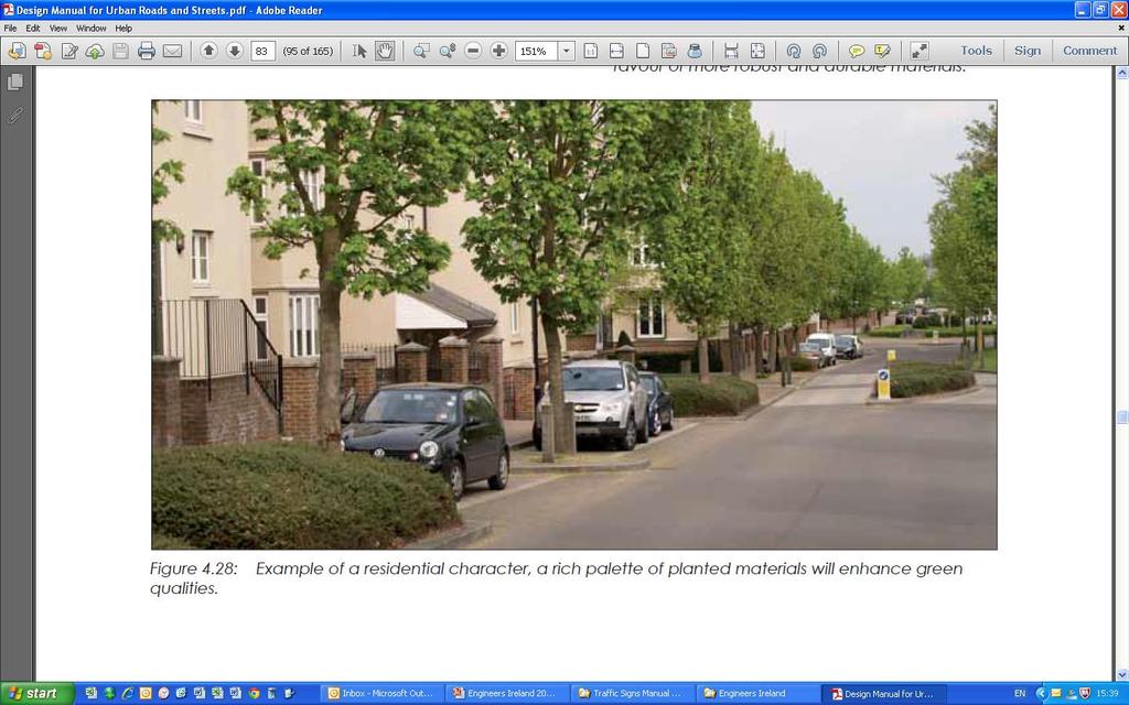
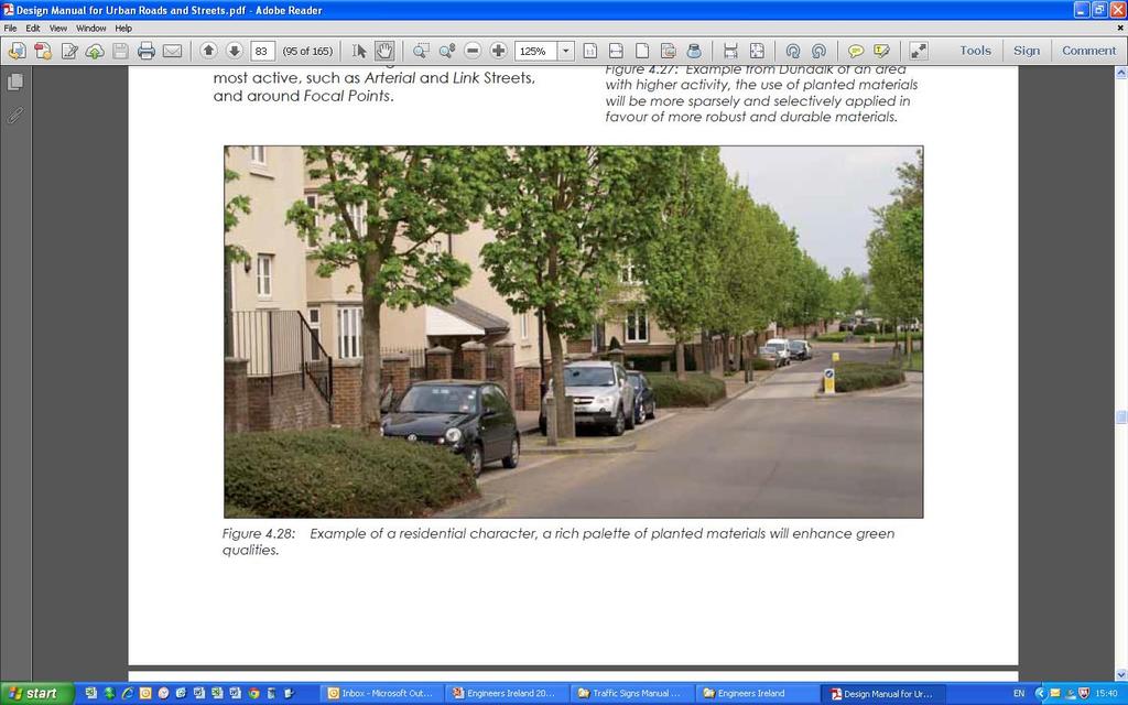
25 DMURS Practical Implications Planting (4.2.7) Provide softer landscape especially in suburbs, neighbourhoods (Fig 4.28) Consider size and types of trees Coordinate with SUDs
26
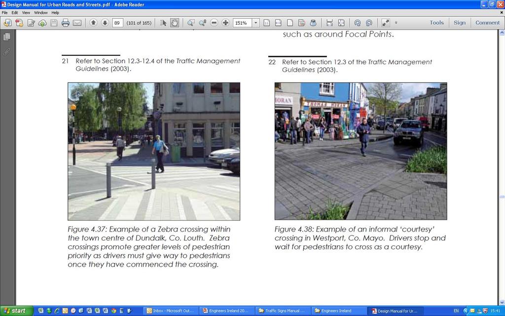
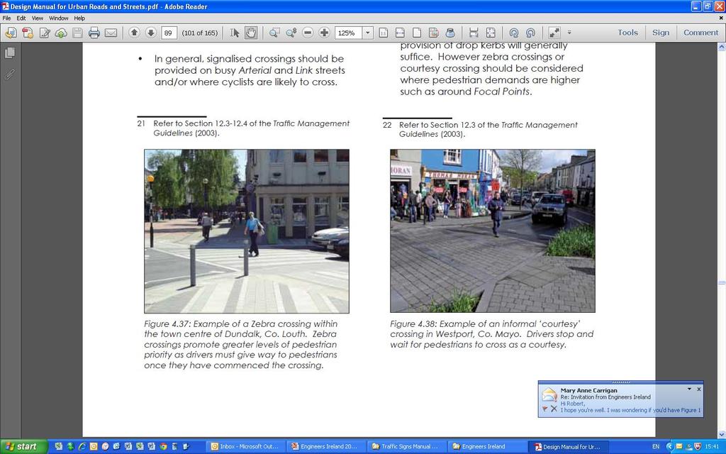
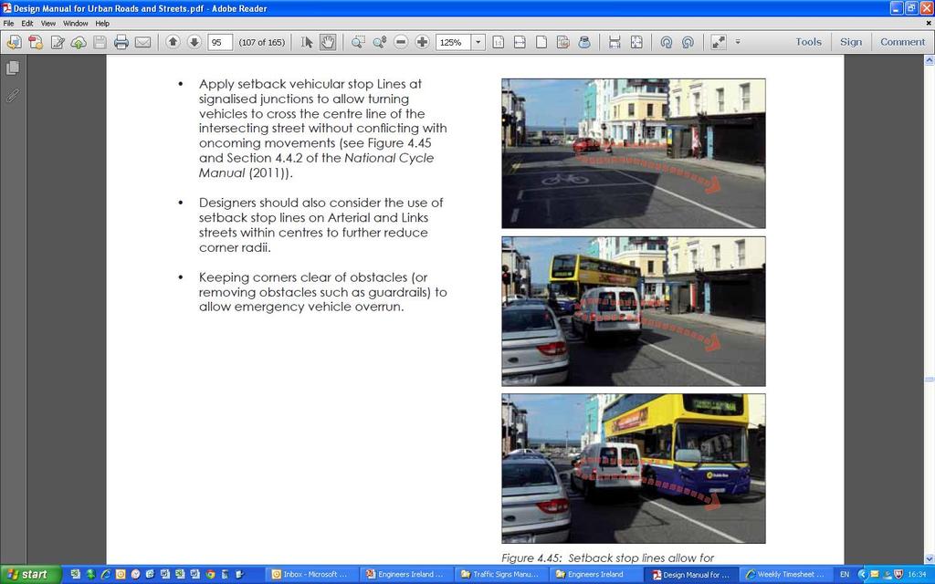
27 DMURS Practical Implications Pedestrians and cyclists (4.3) Footway widths 1.8m 4.0m (Fig 4.34) Pedestrian crossings (4.3.2) Zebras for moderate flows (Fig 4.37) Informal (raised?) courtesy (Fig 4.38) Avoid staggered crossings Minimise crossing distances Provide refuges (with PBUs at signals)
28
29
30 DMURS Practical Implications Corner Radii (4.3.3) Reduce pedestrian crossing distances Reduce vehicle speeds (Fig 4.42) Allow large vehicles to cross centrelines
31
32 DMURS Practical Implications Pedestrianised and shared surfaces (4.3.4) Full pedestrianisation (Figs 4.46) High activity through day and evening Retail, commercial and cultural centres Shared surfaces (Figs 4.46, 4.47) Transport function is low (eg homezones) Careful use of materials No kerbs(?) Minimise carriageway width and entry radii
33
34 DMURS Practical Implications Carriageway widths (4.4.1) Arterial and link streets lane widths min: 3.0m, standard: 3.25m, max: 3.5m Local streets 5.0m - 5.5m carriageway Local shared street 4.8m carriageway Boulevard (Fig 4.55)
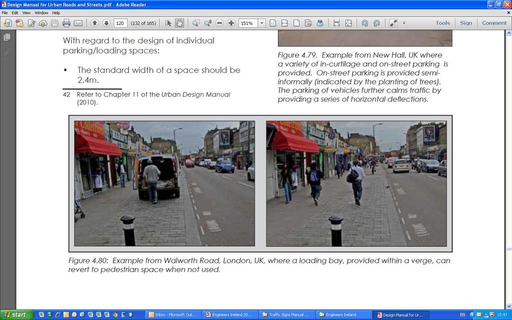
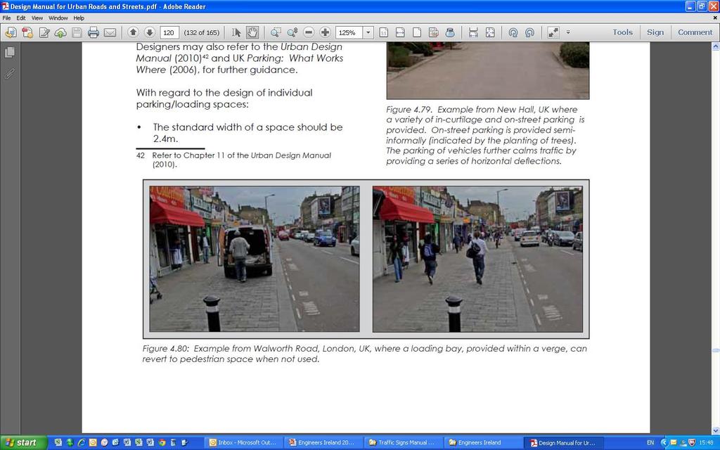
35
36 DMURS Practical Implications Junction Design (4.4.3) Balanced approach not just car capacity Reduce kerb radii Omit left turn slips (Fig 2.8) Signals Ped crossings on all arms Include ped, bike, bus delays in optimisation Minimise cycle times
37
38 DMURS Practical Implications Junction Design (cont d) Roundabouts Large roundabouts not appropriate Difficult for pedestrians and bikes Limited capacity Land take Consider compact/continental roundabouts
39 DMURS Practical Implications Visibility distances (4.4.4) Much lower than DMRB (Table 4.2) Reaction time 1.5 seconds, not 2 seconds Deceleration rate 0.45g, not 0.25g Alignment (4.4.6) Arterial and Link Streets: retain directness Local Streets: speed reducing curves (Fig 4.65)
40 DMURS Practical Implications Sight Stopping Distances (metres) Design Speed DMRB DMURS
41
42 DMURS Practical Implications Horizontal and Vertical Defections (4.4.7) To slow traffic without undue discomfort Horizontal (chicanes, pinch points) Off-set junctions (Local Streets) On-street car parking Vertical (ramps, tables) Long straights (>70m between junctions) Pedestrian crossings Entry treatments
43 DMURS Practical Implications On-street parking and loading (4.4.9) Functions Commercial viability of centres Calm traffic Reduce parking on footpaths
44
45 DMURS Practical Implications What Networks will look like Permeable neighbourhoods More pedestrian crossings No more distributor roads with high walls Inner Relief Roads - retain place function Outer Relief Roads - outside urban area Some level of car congestion
46 DMURS Practical Implications What Streets will look like Narrower carriageways, wider footpaths Tighter corner radii Shorter cycle times at signals Avoid left turn slip roads at junctions No large roundabouts Avoid pedestrian guardrails Less signing and lining More on-street parking
47 Fundamental Message Design urban roads and streets for all users People using them for transport People using them as a place to live
48 Fundamental Message A better balance between the and the Place Function Transport Function of urban roads and streets
DMURS - Practical Implications
 Comhairle Contae Fhine Gall DMURS - Practical Implications Sean McGrath. 13 November 2013 Planning and Strategic Infrastructure Department DMURS Practical Implications What DMURS means for: Street Layouts
Junction Design with Traffic Signals
 Junction Design with Traffic Signals Wednesday March 2 nd 2016 Overview Introduction Context Conventional Approach Sustainable Approach Analysis Design Summary Introduction What are Traffic Signals? Purpose
10 SHERFORD Town Code
 Key Fixes (Ref: Masterplan Book, section 4a. Land Use Budget and Key Fixes ) The Town Plan designs and allocates buildings, streets and spaces as accurately as possible in the understandable absence of
Report from Embassy Visit to Copenhagen May David Arditti
 Report from Embassy Visit to Copenhagen May 2013 David Arditti Standard CPH cycle track, one-way 1.5 2m wide, 5cm above carriageway, 5cm below footway Basic one-way cycle track protected by car parking
IAN WHITE ASSOCIATES. Crawley Station Gateway Public Realm
 IAN WHITE ASSOCIATES Crawley Station Gateway Public Realm contents 1. objectives & client brief 2. site appraisal 3. best practice guidance 4. design concept 1. objectives & client brief Crawley Train
DESIGN CODE. Enterprise West Harlow London Road North Design Code 21
 DESIGN CODE Enterprise West Essex @ Harlow London Road North Design Code 21 4 MAXIMUM BUILDING HEIGHTS 4.1 Table 4A sets out maximum building height standards for each character area within the LDO boundary.
Perne Rd / Radegund Rd Roundabout Cambridge
 Perne Rd / Radegund Rd Roundabout Cambridge The conversion of an conventional urban roundabout to continental geometry A little bit of history The first traffic roundabout was built in Sollershott, Letchworth
Sandyford Cycle Route (Kilgobbin / Drummartin Link Road)
") Sandyford Cycle Route (Kilgobbin / Drummartin Link Road) Public Consultation Report on Submissions Client: Dun Laoghaire-Rathdown County Council Date: May 2018 Job Number: 15_116B Clifton Scannell Emerson
Sandyford Cycle Route (Kilgobbin / Drummartin Link Road) Public Consultation Report on Submissions Client: Dun Laoghaire-Rathdown County Council Date: May 2018 Job Number: 15_116B Clifton Scannell Emerson
Agenda Item 34. N11 - Brewery Road Improvement Scheme
 Agenda Item 34 N11 - Brewery Road Improvement Scheme Public Consultation Report on Submissions Client: Dún Laoghaire-Rathdown County Council Date: November 2017 Job Number: 13_066A Document Pack Page 11
INDEX. Geometric Design Guide for Canadian Roads INDEX
 Acceleration lane, see Lanes, Acceleration Access, 8.1 Access Management and Functional Classification 8.2 Access Management by Design Classification 8.3 Access Configuration 8.4 Building Set-Back Guidelines
Rhebogue Neighbourhood Greenway. Road Safety Audit Stage 2
 Rhebogue Neighbourhood Greenway Road Safety Audit Stage 2 Report Number: 12/007/00/00057 July 2014 Mid West National Road Design Office Lissanalta House, Dooradoyle County Limerick Tel: 061 496 800 Fax:
Appendix A Type of Traffic Calming Measures Engineering Solutions
 Appendix A Type of Traffic Calming Measures Engineering Solutions PHYSICAL MEASURES Central Hatching The major consideration of this feature is that, these markings can only be laid down the centre of
Classification Criteria
 SCHEDULE D TO RECOMMENDED OFFICIAL PLAN AMENDMENT NO. 40 SCHEDULE C-4 Road Criteria Criteria Traffic Service Objective Land Service/Access Typical Daily Traffic Volume Flow characteristics Travel Speed
Part B Design Guidance / Principles _
 Part B Design Guidance / Principles www. landlab.co.nz Queenstown Town Centre Public Realm Design Guidelines Version 7 14 June 2018 Page 006 B1 Design Guidance & Best Practice The Queenstown Town Centre
E4 Cycle Route Exeter University to Redhayes Bridge. - Recommendations from Exeter Cycling Campaign
 E4 Cycle Route Exeter University to Redhayes Bridge - Recommendations from Exeter Cycling Campaign 1.0 Introduction Exeter Cycling Campaign has prepared this report to provide recommendations for Devon
Issues at T junctions:
 TheSlade_PublicConsulationPlans_March2017.pdf These comments relate to junction designs in this phase of the project on The Slade. Comments begin with the northernmost junction: Girdlestone Rd and continue
Road Safety Audit training course. Motorways - safety issues of the motorway design
 Road Safety Audit training course Motorways - safety issues of the motorway design Jesper Mertner, Road safety auditor, COWI A/S 1 ROAD SAFETY AUDITING COURSE Content 1. Safety 2. Cross sections 3. Horizontal
TRAFFIC CALMING GUIDE FOR TORONTO CITY OF TORONTO TRANSPORTATION SERVICES DIVISION
 TRAFFIC CALMING GUIDE FOR TORONTO CITY OF TORONTO TRANSPORTATION SERVICES DIVISION CITY OF TORONTO TRANSPORTATION SERVICES DIVISION 2016 TRAFFIC CALMING GUIDE FOR TORONTO TABLE OF CONTENTS Introduction
Entry Treatments. Traffic Advisory Leaflet 2/94 August Introduction. Design. Vertical Deflections. Locations
 Traffic Advisory Leaflet 2/94 August 1994 Entry Treatments Introduction Entry treatments have been developed for use at side roads so that drivers leaving a major road are in no doubt that they are entering
Cabinet Member for Highways & Streetscene. Highway Infrastructure Manager
 LONDON BOROUGH OF RICHMOND UPON THAMES DATE: AUGUST 2015 DECISION MAKER: LEAD OFFICER: SUBJECT: WARDS: Cabinet Member for Highways & Streetscene Highway Infrastructure Manager PROPOSED CYCLING IMPROVEMENTS
Manual for Streets 2: Digested Read
 Manual for Streets 2: Digested Read Technical Information Note No. 24 September 2011 About Sustrans Sustrans makes smarter travel choices possible, desirable and inevitable. We re a leading UK charity
Tonight is for you. Learn everything you can. Share all your ideas.
 Strathcona Neighbourhood Renewal Draft Concept Design Tonight is for you. Learn everything you can. Share all your ideas. What is Neighbourhood Renewal? Creating a design with you for your neighbourhood.
Why do we need checklists?
 Support for Implementing Measures for the South East Core Regional Transport Network Multi Annual Plan (EuropeAid/125783/C/SER/MULTI) The RSA Checklists core part of the Manual (RSA part 2) by L. Pfeiffer
What Is a Complete Street?
 Session 5 Charleen Zimmer, AICP, Zan Associates May 5-7, 2010 What Is a Complete Street? May 2010 5-1 Not a Complete Street More of a Complete Street May 2010 5-2 Benefits of Complete Streets Safety for
Guide to Road Design Part 3: Geometric Design Session I 18 October 2016
 Guide to Road Design Part 3: Geometric Design Session I 18 October 2016 Today s moderator Angela Racz Online Training Coordinator Knowledge Transfer - ARRB Group P: +61 3 9881 1694 E: training@arrb.com.au
Dodder Greenway Emerging Preferred Route Consultation - October 2018
 Dodder Greenway Emerging Preferred Route Consultation - October 2018 1.0 Introduction Dublin Cycling Campaign is the advocacy group for cycling in Dublin. Dublin Cycling Campaign is the leading member
Marcus Jones, TRL. Presented by Name Here Job Title - Date
 Segregation Insert the title and of priority your at presentation junctions: a here discussion Marcus Jones, TRL Presented by Name Here Job Title - Date Background: TfL cycle facility trials Infrastructure
The Rower Traffic Management Scheme
 KILKENNY COUNTY COUNCIL Comhairle Chontae Chill Chainnigh Section 38 of the Road Traffic Act, 1994 as amended by the Public Transport Regulation Act, 2009 (Section 46) The Rower Traffic Management Scheme
CHECKLIST 2: PRELIMINARY DESIGN STAGE AUDIT
 CHECKLIST 2: PRELIMINARY DESIGN STAGE AUDIT 2.1 General topics 2.1.1 Changes since previous audit Do the conditions for which the scheme was originally designed still apply? (for example, no changes to
Frascati Road and Temple Hill Route Improvements. Outline Design Report to Accompany Public consultation
 Frascati Road and Temple Hill Route Improvements Outline Design Report to Accompany Public consultation September 2013 Background: Dún Laoghaire-Rathdown is committed to providing high quality pedestrian
City of Wayzata Comprehensive Plan 2030 Transportation Chapter: Appendix A
 A1. Functional Classification Table A-1 illustrates the Metropolitan Council s detailed criteria established for the functional classification of roadways within the Twin Cities Metropolitan Area. Table
11 CHECKLISTS Master Checklists All Stages CHECKLIST 1 FEASIBILITY STAGE AUDIT
 11 CHECKLISTS 11.1 Master Checklists All Stages CHECKLIST 1 FEASIBILITY STAGE AUDIT 1.1 General topics 1. Scope of project; function; traffic mix 2. Type and degree of access to property and developments
Road Description Max. No. of Design Speed C'way and Description and Comments Type Dwellings served footway details
 Road Description Max. No. of Design Speed C'way and Description and Comments Type Dwellings served footway details 1 Local - 50 kph 7.3m Multi-purpose local road, generally forming part of local Distributor
Footpath design. A guide to creating footpaths that are safe, comfortable, and easy to use
 Footpath design A guide to creating footpaths that are safe, comfortable, and easy to use November 2013 Contents Introduction / 1 Zoning system / 2 Width / 4 Height / 5 Surface / 5 Footpath elements /
High frequency bus services operating to Little Island; Creation of a new Park and Ride site and train station at North Esk;
 Cork County Council 7 th December 2018 Dear Adrian O Neill (aoneill@jbbarry.ie) The Transport and Mobility Forum, Cork (TMF) is a representative group of organisations who have a common interest in sustainable
GEOMETRIC DESIGN OF ROUNDABOUTS AND TRAFFIC S IGNAL SIGNAL CONTROLLED
 TD 16/07 and TD 50/04 GEOMETRIC DESIGN OF ROUNDABOUTS AND TRAFFIC SIGNAL CONTROLLED JUNCTIONS DMRB Vol 6 File 6 0 ROUNDABOUTS: INTRODUCTION Principles Roundabout Types Entry Deflection Capacity Visibility
Chapter 4 - Links Within the Highway. Suitability of Routes
 Chapter 4 - Links Within the Highway Suitability of Routes Most cycling takes place on existing urban roads; this will also be the case with the National Cycle Network. As well as following lightly trafficked
4.1 Introduction. 4.2 Aspects of walkable communities
 4 Community walkability Community walkability Making communities walkable Urban form Feeling secure 4.1 Introduction Walkability describes the extent to which the built environment is walking-friendly.
Introduction Methodology Study area and data collection Results and recommendation Conclusion References
 Introduction Methodology Study area and data collection Results and recommendation Conclusion References It is formal procedure for assessing accident potential and safety performance in the provision
Cyclists at road narrowings
 Traffic Advisory Leaflet 1/97 February 1997 Cyclists at road narrowings Introduction Traffic calmed streets can offer a more attractive environment for cycling, by reducing motor vehicles speeds to a level
Figure 3B-1. Examples of Two-Lane, Two-Way Marking Applications
 Figure 3B-1. Examples of Two-Lane, Two-Way Marking Applications A - Typical two-lane, two-way marking with passing permitted in both directions B - Typical two-lane, two-way marking with no-passing zones
Appendix 12 Parking on footways and verges
 Appendix 12 Parking on footways and verges Legal position Parking on footways and verges whether wholly or partly is banned throughout London, unless signs are placed to allow parking. The ban requires
PLACEMENT OF SIGNS RECOMMENDED PRACTICES SUB-SECTION
 Page 1 of 6 RECOMMENDED PRACTICES PART SECTION SUB-SECTION HIGHWAY SIGNS GENERAL General Proper positioning of signs is an important element in the overall control of traffic within a roadway network.
Review of Guidelines for Cycleway Safety Fencing
 Review of Guidelines for Cycleway 1.0 PURPOSE 1.1 This document is meant to provide a review of available reference documents for determining appropriate fencing requirements for cycleway paths and shared
ROUNDABOUTS/TRAFFIC CIRCLES
 GENERAL 1. Description This standard identifies minimum requirements that shall be met for Roundabouts and Neighborhood Traffic Circles in the design and construction of elements for Arlington County Horizontal
Retrofitting Urban Arterials into Complete Streets
 Retrofitting Urban Arterials into Complete Streets John N. LaPlante, P.E., P.T.O.E., T.Y. Lin International Prepared for: Illinois Traffic Engineering & Safety Conference Urbana, Illinois October 18, 2007
Kings Road, Herne Bay: Proposed Crash Remedial Measure
 Kings Road, Herne Bay: Proposed Crash Remedial Measure To: Canterbury Joint Transportation Board 17 February 2015 By: Classification: Ward: Tim Read - Head of Transportation Unrestricted Herne Bay Summary:
TOWN OF HALTON HILLS TRAFFIC CALMING PROTOCOL. Page 1 of 25
 TOWN OF HALTON HILLS TRAFFIC CALMING PROTOCOL Page 1 of 25 PROCESS FOR INSTALLATION OF TRAFFIC CALMING DEVICES The Process for Installation of Traffic Calming Devices has been prepared to provide an objective
A5.1 Permitted activities
 Section A5 Transportation A5.1 Permitted activities A5.1.1 Activities within roads Note: Refer to Section D for the definition of road (a) Any activity associated with the movement of traffic and the functioning
Strategy for Walking & Cycling Action Plan
 Strategy for Walking & Cycling Action Plan To achieve higher levels of walking and cycling activity, the destinations which people access have to be available within suitable distances and designed to
AUTOMATED AND ZERO EMISSION VEHICLES HOW THEY MIGHT RESHAPE OUR STREETS
 AUTOMATED AND ZERO EMISSION VEHICLES HOW THEY MIGHT RESHAPE OUR STREETS STURT ST BALLARAT WATERGARDENS TAYLORS LAKES SIMPSON ST YARRAVILLE CHAPEL ST SOUTH YARRA RINGWOOD STATION MONASH FREEWAY SA NSW VIC
How do we design for pedestrians? Case study: transforming the Walworth Road
 How do we design for pedestrians? Case study: transforming the Walworth Road David Moores, Director of Public Realm Institution of Highways and Transportation, November 2009 Presentation overview Design
CITY OF SAINT JOHN TRAFFIC CALMING POLICY
 CITY OF SAINT JOHN TRAFFIC CALMING POLICY VERSION: 1.0 April 10, 2012 Pedestrians, Cyclists and Motorists Sharing Street Spaces CONTENTS INTRODUCTION... 3 POLICY GOAL... 3 POLICY OBJECTIVES... 3 GUIDING
Limerick City & County Council Traffic Calming Policy for Urban Areas DRAFT
 Limerick City & County Council Traffic Calming Policy for Urban Areas DRAFT Physical Development Directorate February 2018 Traffic Calming in Limerick City Minister Donohue launches 30kph Slow Zone Sign
Article All citizens shall, as human persons, be held equal before the law.
 BUNREACHT NA héireann CONSTITUTION OF IRELAND Article 40 1. All citizens shall, as human persons, be held equal before the law. This shall not be held to mean that the State shall not in its enactments
Public Consultation on Braintree Integrated Transport Package (ITP) HAVE YOUR. Consultation open from 24 September to 5 November 2018 SAY
 HAVE YOUR. Consultation open from 24 September to 5 November 2018 SAY") Public Consultation on Braintree Integrated Transport Package (ITP) HAVE YOUR SAY Consultation open from 24 September to 5 November 2018 Contents Introduction 3 Background 4 Springwood Drive Roundabout
Public Consultation on Braintree Integrated Transport Package (ITP) HAVE YOUR SAY Consultation open from 24 September to 5 November 2018 Contents Introduction 3 Background 4 Springwood Drive Roundabout
Dún Laoghaire Rathdown County Council. Luas to Dart via UCD Cycle and Pedestrian Route
 Dún Laoghaire Rathdown County Council Luas to Dart via UCD Cycle and Pedestrian Route October 2012 Luas to Dart via UCD Cycle and Pedestrian Route DOCUMENT CONTROL SHEET Client: Project Title: Document
Chelmsford City Growth Package
 Chelmsford City Growth Package Public Consultation Document Volume 2 West Chelmsford July - August 2017 Chelmsford City Growth Package Public Consultation Document - Volume 2 - West Chelmsford Contents
Sevenways Roundabout, and the need for a Road Safety Scheme:
 Sevenways Roundabout, and the need for a Road Safety Scheme: The way the current roundabout has evolved has obviously created an environment that is dangerous for all road users, motorists, cyclists and
Policy Statement. Objective. Context. References and Supporting Documentation
 Policy Statement Subject Placement of Distribution Poles Along Roads With Speed Limits Not Exceeding 70km/h Approved by Robert Rogerson Signature & Date Distribution Standards and Policy Manager Authorised
AUTOMATED AND ZERO EMISSION VEHICLES HOW THEY MIGHT RESHAPE OUR STREETS
 AUTOMATED AND ZERO EMISSION VEHICLES HOW THEY MIGHT RESHAPE OUR STREETS BACKGROUND: This study is a collaboration between Urban Circus (Visualisation) and Ethos Urban (Urban Design) Ideas were workshopped
T10:2012 Site Category 1a) T10:2012 Site Category 1b) Railway Level Crossing Approach Traffic Signal Approach Event Code F Event Code E
 T10:2012 Site Category 1b) Railway Level Crossing Approach Traffic Signal Approach Event Code F Event Code E") T10:2012 Site Category 1a) Railway Level Crossing Approach Event Code F T10:2012 Site Category 1b) Traffic Signal Approach Event Code E Traffic signals Crosswalk T10:2012 Site Category 1c) Pedestrian Crossing
T10:2012 Site Category 1a) Railway Level Crossing Approach Event Code F T10:2012 Site Category 1b) Traffic Signal Approach Event Code E Traffic signals Crosswalk T10:2012 Site Category 1c) Pedestrian Crossing
Easton Safer Streets - Final Project Report BRISTOL
 - Final Project Report BRISTOL A Sustrans Community Street Design Project in partnership with Bristol City Council February 07 About Sustrans Sustrans makes smarter travel choices possible, desirable and
Complete Streets. Designing Streets for Everyone. Sarnia
 Complete Streets Designing Streets for Everyone Sarnia Complete Streets ~ Sarnia ~ 2018 Introduction Our City is made up of a network of streets that we use to go for a walk, cycle to work, drive to the
Grade-separation for cyclists includes cycling bridges and cycling tunnels, specially built for cyclists and possibly co-used by pedestrians.
 Infrastructure Give Cycling a Push INFRASTRUCTURE/ INTERSECTIONS AND CROSSINGS GRADE SEPARATION Overview Gradeseparation for cyclists includes cycling tunnels and cycling bridges. These are safe and direct
Report. Typical Sections. City of Middleton, WI
 Report Typical Sections City of Middleton, WI December 2006 Report for City of Middleton, Wisconsin Typical Sections repared by: Traffic Associates LLC and STRAND ASSOCIATES, INC. 910 West Wingra Drive
Chicane Schemes. Traffic Advisory Leaflet 12/97 December Introduction
 Traffic Advisory Leaflet 12/97 December 1997 Chicane Schemes Introduction Traffic Advisory Leaflet 9/94 "Horizontal Deflections" reported on the results of track trials carried out by the Transport Research
Liveable Neighbourhoods Design Code and Policy
 CNU London Transportation Summit, November 2007 The West Australian Liveable Neighbourhoods Design Code and Policy Incorporating a New Urbanist Street Design Manual for New Communities Wendy Morris Ecologically
Appendix C. TRAFFIC CALMING PROGRAM TOOLBOX
 Appendix C. TRAFFIC CALMING PROGRAM TOOLBOX PHASE I...2 Do Not Enter Sign...3 One-Way Sign...4 Turn Prohibition...5 Pavement Markings...6 Speed Monitoring Trailer...7 Neighborhood Speed Watch...8 Police
The Cabinet Member for Highways & Streetscene. Aurang Zeb - Head of Highways & Transport
 LONDON BOROUGH OF RICHMOND UPON THAMES Cabinet Member Decision DATE: January 2012 REPORT OF: LEAD OFFICER: SUBJECT: WARDS: The Cabinet Member for Highways & Streetscene Aurang Zeb - Head of Highways &
Intersection Safety 6/7/2015 INTERSECTIONS. Five basic elements should be considered in intersection design. Intersection Safety (continued)
") Intersection Safety S. M. SOHEL MAHMUD Assistant Professor Accident Research Institute (ARI), Bangladesh University of Engineering and Technology (BUET) Dhaka-1000, Bangladesh 1 Outline of the Presentation
Intersection Safety S. M. SOHEL MAHMUD Assistant Professor Accident Research Institute (ARI), Bangladesh University of Engineering and Technology (BUET) Dhaka-1000, Bangladesh 1 Outline of the Presentation
Living Streets response to the Draft London Plan
 Living Streets response to the Draft London Plan Contents Living Streets response to the Draft London Plan... 1 About Living Streets... 2 Summary... 2 Consultation response... 3 Chapter 1: Planning London
CLOSED. The draft concept design has been broken down into 5 categories for the purpose of this survey:
 Old Strathcona s neighbourhood renewal process is now at the draft concept design phase. Over the last several months, the city has been gathering local knowledge and resident input that has been used
INTERSECTIONS AT GRADE INTERSECTIONS
 INTERSECTIONS 1 AT GRADE INTERSECTIONS INTERSECTIONS INTERSECTIONS = INTERRUPTED FACILITIES Definitions and key elements An intersection is defined as an area where two or more roadways join or cross.
Auckland Transport Code of Practice 2013
 P age 204 8 Traffic Calming Devices and Local Area Traffic Management (LATM) 8.1 Local Area Traffic Management Governing Principle Traffic calming and/or devices are often used as a means to improve the
Douglas Land Use and Transportation Strategy (DLUTS) Summary. August 2013
 Summary. August 2013") Douglas Land Use and Transportation Strategy (DLUTS) Summary August 2013 Background Douglas is a large and popular residential suburb of approximately 30,000 persons on the periphery of Cork City along
Douglas Land Use and Transportation Strategy (DLUTS) Summary August 2013 Background Douglas is a large and popular residential suburb of approximately 30,000 persons on the periphery of Cork City along
Bike-sharing. The State of Play:
 Bike-sharing Dock-less bike-sharing schemes have recently commenced in major Australian cities and they seem to have polarised the community. While the schemes are having positive impacts in urban areas,
14. PROPOSED PEDESTRIAN CROSSING IMPROVEMENTS IN MOORHOUSE AVENUE
 165 14. PROPOSED PEDESTRIAN CROSSING IMPROVEMENTS IN MOORHOUSE AVENUE General Manager responsible: General Manager City Environment, DDI 941-8528 Officer responsible: Transport and Greenspace Unit Manager
FOCUS AREA 1 - Alberta Avenue Pocket Park 3 (121 Ave and 92 St)
") FOCUS AREA 1 - Alberta Avenue Pocket Park 3 (121 Ave and 92 St) New benches Plant evergreen trees Widen existing sidewalk from 1.5m to 1.8m Marked crosswalk 1.8m wide sidewalk Add pedestrian oriented lights
FOCUS AREA 1 - Alberta Avenue Pocket Park 3 (121 Ave and 92 St) New benches Plant evergreen trees Widen existing sidewalk from 1.5m to 1.8m Marked crosswalk 1.8m wide sidewalk Add pedestrian oriented lights
Cycle traffic and the Strategic Road Network. Sandra Brown, Team Leader, Safer Roads- Design
 Cycle traffic and the Strategic Road Network Sandra Brown, Team Leader, Safer Roads- Design Highways England A Government owned Strategic Highways Company Department for Transport Road Investment Strategy
Broad Street Bicycle Boulevard Design Guidelines
 Broad Street Bicycle Boulevard Design Guidelines Building from the strategies introduced in the 2013 Bicycle Transportation Plan and community input received thus far, City Transportation Staff have identified
LEA BRIDGE ROAD - A STREET FOR EVERYONE Public consultation document
 LEA BRIDGE ROAD - A STREET FOR EVERYONE Public consultation document TELL US Bakers Arms to Leyton Green Road (Section D, E, F) Leyton Green Road to Whipps Cross Roundabout (Section G) YOUR VIEWS www.enjoywalthamforest.co.uk
CURB EXTENSIONS BULB OUTS DPS 201 NECKDOWNS
 CURB EXTENSIONS BULB OUTS DPS 201 NECKDOWNS WHY WHEN & WHERE When Limited Sight Distance Pedestrians & Vehicles Vehicles and Signs Want to put two curb ramps in Discourage High speed turning High number
Bulwell Cycling Consultation
 Bulwell Cycling Consultation Image 1 Bulwell Bogs (Sutton, 2015) As part of a final year research project, I am seeking feedback on proposals for cycling improvements in Bulwell. This consultation is not
IMPLEMENTATION. PEDESTRIAN USERS (Continued /) A: Class 2 Pedestrian / Cycle Ways. Pedestrian and Cycle Ways:
 A: Class 2 Pedestrian / Cycle Ways. Pedestrian and Cycle Ways:") A: Class 2 Pedestrian / Cycle Ways PLAN VIEW Pedestrian and Cycle Ways: Layout and Geometry (Refer to A): Walkways and cycle to be provided adjacent to all Class 2 Roads (these facilities should always
A: Class 2 Pedestrian / Cycle Ways PLAN VIEW Pedestrian and Cycle Ways: Layout and Geometry (Refer to A): Walkways and cycle to be provided adjacent to all Class 2 Roads (these facilities should always
Traffic calming regulations (Scotland)
") Traffic Advisory Leaflet 11/94 December 1994 Traffic calming regulations (Scotland) Introduction Traffic calming can help drivers to make their speeds appropriate to local conditions, through measures
Traffic Advisory Leaflet 11/94 December 1994 Traffic calming regulations (Scotland) Introduction Traffic calming can help drivers to make their speeds appropriate to local conditions, through measures
Design and Installation of Low Level Cycle Signals
 Transport for London Surface Transport Management System Document Guidance Note Design and Installation of Low Level Cycle Signals Document reference: SQA-0651 - Issue: Draft out of date information. 1
Mapping Cycle-friendliness towards a national standard
 Mapping Cycle-friendliness towards a national standard Cyclenation in collaboration with CTC would like the guidance contained in the appendices to this paper to be adopted as the national standard for
RIGHT-OF-WAY INTERSECTIONS
 Infrastructure Give Cycling a Push INFRASTRUCTURE/ INTERSECTSIONS AND CROSSINGS RIGHT-OF-WAY INTERSECTIONS Overview Right-of-way mixed traffic is the simplest, most agreeable approach for cyclists on quiet
Traffic Calming Regulations
 Traffic Advisory Leaflet 7/93 August 1993 Traffic Calming Regulations Introduction Traffic calming can help drivers to make their speeds appropriate to local conditions, through measures which are self-enforcing.
A6 Manchester Airport Relief Road
 A6 Manchester Airport Relief Road Status Date Author Approved for Issue (AECOM) Approved for Issue (Grontmij) P0 18 July 2014 Adam Richardson Martin Houghton Martin Williamson P1 06 August 2014 Tony Hickman
11.2 Detailed Checklists CHECKLIST 1: FEASIBILITY STAGE AUDIT. 1.1 General topics Scope of project; function; traffic mix
 11.2 Detailed Checklists CHECKLIST 1: FEASIBILITY STAGE AUDIT 1.1 General topics 1.1.1 Scope of project; function; traffic mix What is the intended function of the scheme? Is the design consistent with
TGSI Tactile Ground Surface Indicators
 TGSI Tactile Ground Surface Indicators Introduction: This Design Note, No 11, provides guidelines and requirements for the use and installation of Tactile Ground Surface Indicators (TGSI s). References
Helen Hughes Senior Project Manager
 Helen Hughes Senior Project Manager hhughes@nra.ie What is a 2+1 Road? A road with two lanes in one direction and one in in the other The two lane section is provided alternately for each direction of
Public Open House #2. THE CITY OF NORTH VANCOUVER CHESTERFIELD AVENUE CYCLING IMPROVEMENTS (4th - 13th STREET) JULY 2013
 JULY 2013") CHESTERFIELD AVENUE CYCLING IMPROVEMENTS (4th - 13th Street) Public Open House #2 1 Chesterfield Avenue provides an important north/south connection between Lonsdale Quay and West 23rd Street Purpose of
CHESTERFIELD AVENUE CYCLING IMPROVEMENTS (4th - 13th Street) Public Open House #2 1 Chesterfield Avenue provides an important north/south connection between Lonsdale Quay and West 23rd Street Purpose of
Copenhagen Cycling Map. Red Lines Cycling facilities
 Copenhagen Cycling Map Red Lines Cycling facilities Copenhagen Cycling Facilities Design Approaches Transportation without Pollution Copenhagen s Strategy Where Cycling is one of the top key activities
M9/A90/M90 Edinburgh to Fraserburgh Trunk Road. A90 Tealing. Moving Cursor Programme Junction Study
 A90 Tealing Moving Cursor Programme Junction Study This is an unpublished report prepared for the Transport Scotland, Trunk Road and Bus Operations Division (TRBO) and must not be referred to in any publication
Road safety design standards and the Asian Highway Network. irap Asia Pacific Workshop Greg Smith 2016/05/26
 Road safety design standards and the Asian Highway Network irap Asia Pacific Workshop Greg Smith (greg.smith@irap.org) 2016/05/26 AH Standard Summary While developing the Asian Highway network, Parties
* With exceptions for topography or special circumstances.
 Block Length Limits* Salem, OR 600 ft (180 m) Portland, OR Davidson, NC Raleigh, NC Fort Collins, CO Boulder, CO 530 ft 600 ft 1,500 ft Max block size (7-12 acres) 350 ft (by practice) * With exceptions
Ministry of Education Flat Bush School Notice of Requirement. Integrated Transportation Assessment Report. February 2016
 Ministry of Education Flat Bush School Notice of Requirement Integrated Transportation Assessment Report February 2016 TDG Ref: 12988-2 151105 ita flat bush.docx Ministry of Education Flat Bush School