harrison street/oakland avenue community transportation plan C i t y o f O a k l a n d F e b r u a r y 8,
|
|
|
- Sheena Barrett
- 5 years ago
- Views:
Transcription


1 F e b r u a r y 8, harrison street/oakland avenue community transportation plan C i t y o f O a k l a n d
2
3 f e b r u a r y 8, harrison street/oakland avenue community transportation plan C i t y o f O a k l a n d Submitted by In Association with Dowling Associates, Inc.
4
5 TABLE OF CONTENTS ACKNOWLEDGEMENTS... iii EXECUTIVE SUMMARY... v 1. INTRODUCTION EXISTING CONDITIONS COMMUNITY PARTICIPATION PLAN RECOMMENDATIONS IMPLEMENTATION AND FUNDING Appendices Appendix A: Harrison Street/Oakland Avenue CTP Existing Circulation Conditions Appendix B: Three Design Alternatives, and Harrison Street/Oakland Avenue CTP Project Alternatives Memo Appendix C: Harrison Street/Oakland Avenue CTP Draft Concept Plan Memo Appendix D: Transportation Analysis Appendices i
6 TABLE OF CONTENTS List of Figures Figure 2-1 Plan Area Context Figure 2-2 Council Districts Figure 2-3 Plan Area Figure 2-4 Average Weekday Daily Traffic Figure 2-5 Existing Vehicle Intersection Level of Service Figure 2-6 Peak Hour Pedestrian Intersection Crossing Counts Figure 2-7 Peak Hour Bicycle Intersection Approach Counts Figure 2-8 AC Transit Weekday Passenger Boarding and Alighting Figure 2-9 Pedestrian Stairways Figure 4-1 Bike Lane Improvements Figure 4-2 Proposed Bus Stop Relocations Figure 4-3 Parking Changes List of Tables Table 2-1 Daily Vehicle Counts Summary Table 2-2 Intersection Levels of Service for Existing Conditions Table 4-1 Intersection Levels of Service Existing Conditions Table 4-2 Intersection Levels of Service 2035 Conditions Table 5-1 Community Workshop Prioritization Results Table 5-2 Potential Public Funding Sources by Project Type Table 5-3 Recommendations and Implementation Actions ii
7 ACKNOWLEDGEMENTS Thank you to all who participated. A. Project Team Alisa Shen, Planning & Zoning Division, Strategic Planning, City of Oakland Christina Ferracane, Planning & Zoning Division, Strategic Planning, City of Oakland Bruce Brubaker, Design, Community and Environment (DC&E) John Hykes, DC&E Sadie Mitchell, DC&E Mark Bowman, Dowling Associates Kamala Parks, Dowling Associates B. Technical Advisory Committee (TAC) Caltrans District 4 Beth Thomas, Senior Transportation Planner, Office of Transit & Community Planning Anh P. Nguyen, Transportation Planner, Office of Transit & Community Planning City of Oakland Si Lau, Transportation Engineer, Traffic Safety Program, Transportation Services Division Jason Patton, Bicycle and Pedestrian Program Manager, Transportation Services Division Frank Awayan, Assistant Engineer, Dept. of Engineering and Construction Jose Martinez, CIP Coordinator, Dept. of Engineering and Construction AC Transit Nathan Landau, Project Manager, Service and Operations Planning Ajay Martin, Transportation Planner, Service and Operations Planning iii
8 ACKNOWLEDGEMENTS C. Community Steering Committee (CSC) Jerry Cauthen, Grand Lake Traffic Calming Committee Lina Foltz, Adams Point Action Council (APAC)/14 X Kathryn Hughes, Vista Neighborhood Association Jennifer Jackson, Walk Oakland Bike Oakland Kent Lewandowski, BPAC, Sierra Club East Bay Chapter Patricia Maurice, Piedmont Avenue Neighborhood Improvement League Barton Mayhew, HarriOak Neighborhood Association Susan Ode Kathy Orsini, HarriOak Neighborhood Association Stephanie Robillard, Westlake Middle School Naomi Schiff, Oakland Heritage Alliance Maria Barra-Gibson, Council District 1 Joanne Karchmer, Council District 2 Carletta Starks, Council District 3 iv
9 EXECUTIVE SUMMARY The Harrison Street/Oakland Avenue Community Transportation Plan (CTP) is the result of technical analysis and community outreach conducted in to identify transportation needs and solutions for the CTP area. The Plan was primarily funded by a Community Based Transportation Planning (CBTP) grant from Caltrans and overseen by Caltrans and the City of Oakland. A. Goals The goal of the Harrison Street/Oakland Avenue CTP was to work with a diverse group of stakeholders, including local residents, City staff and public agencies, to create a vision for calming traffic along Harrison Street and Oakland Avenue between Grand Avenue and the Oakland-Piedmont border, and to improve the livability of the surrounding neighborhood that was impacted by the construction of the Interstate 580 freeway in the 1960s. The Plan sets forth a comprehensive and long-term vision for this section of Harrison Street and Oakland Avenue and connecting streets that includes recommendations for capital improvements and a detailed discussion of next steps to inform future implementation of Plan recommendations. In September of 2008, the California Complete Streets Act of 2008 was signed into law. Complete streets are roads which are designed to accommodate all users, including pedestrians, bicyclists, children, the elderly, persons with disabilities, transit riders, and motorists. The legislation requires that cities and counties include complete streets policies as part of their General Plans so that roadways are designed to safely accommodate all users. The Land Use and Transportation Element (LUTE) of the City of Oakland General Plan (1998) has a number of policies and plans which were developed to promote better pedestrian, transit and bicycle environments. As an outcome of policy directives of the LUTE, the City of Oakland developed a Pedestrian Master Plan (2002) and a Bicycle Master Plan (2007), which outline specific goals and objectives to promote walking, making streets safer and v
10 EXECUTIVE SUMMARY more enjoyable for pedestrians and bicyclists. Specific policies and objectives that are pertinent to this CTP are outlined in Chapter 2: Existing Conditions. Previous planning efforts have addressed specific concerns within the Plan Area. 1 However, none of those plans entailed a comprehensive look at the entire Plan Area and all the roadway users. This Plan comprehensively address the multiple needs of all the roadway users and work to create a Plan that balances the needs of all users of the roadway and meet the goals set forth by the California Complete Streets Act and the California Department of Transportation, as elaborated in Chapter 1: Introduction. B. Plan Area Description The Plan Area of the Harrison Street/Oakland Avenue CTP is an approximately one-mile long section of Harrison Street and Oakland Avenue. Harrison Street and Oakland Avenue run parallel to each other, spanning a very dense and diverse transect of the City of Oakland. The streets connect Grand Avenue, adjacent to Lake Merritt in Downtown Oakland, to Monte Vista Avenue at the border between the cities of Oakland and Piedmont. C. Overview of Planning Approach The planning process consisted of four stages: analysis of existing conditions, development of conceptual design alternatives, refinement of a preferred design concept, and preparation of the final plan. Throughout each of these stages the Project Team met with the Technical Advisory Committee and the 1 Previous studies conducted on portions of Harrison Street and Oakland Avenue include a 1994 Dowling Associates study on the feasibility of a two-way conversion of the two streets north of MacArthur Blvd., as well as an MTC-funded Traffic Engineering Technical Assistance Program (TETAP) study to analyze traffic calming solutions along Harrison St. and Oakland Avenue between Grand Avenue and I- 580, conducted by Kimley Horn Associates (2007) vi
11 EXECUTIVE SUMMARY Community Steering Committee (TAC/CSC), which were groups of City and public agency staff and a community stakeholder group, respectively; as well as held several community workshops for the public at-large. The four stages are briefly described below: 1. Existing Conditions Analysis The Project Team met with City and agency staff, community stakeholders, and the TAC/CSC to gain a better understanding of the concerns and issues regarding the Plan Area. Field research and technical analysis of existing traffic conditions were undertaken as part of this stage. 2. Conceptual Alternatives Development Based upon the analysis of existing conditions and feedback received from the TAC/CSC and from community workshops, the Project Team created three alternative design concepts for the Plan Area. The alternatives were analyzed in regards to their affect on traffic and circulation in the Plan Area and presented to the TAC/CSC for input and later to the community at a community workshop. Workshop participants provided feedback on the designs. 3. Preferred Concept Refinement Based on input from the community and the TAC/CSC, the Project Team developed and refined a Preferred Concept for the Plan Area. The traffic and circulation affects of the Preferred Concept were analyzed, and the Preferred Concept was presented to the TAC/CSC for input and later to the community at a community workshop. The workshop participants gave input and guidance on the Preferred Concept. 4. Final Plan Preparation The Project Team refined the preferred concept based upon the TAC/CSC and community input. The Final Plan was developed, including specific recommendations, cost estimates, and an outline of the next steps required for implementation of the recommendations. vii
12 EXECUTIVE SUMMARY D. Plan Recommendations The focus of the Harrison Street/Oakland Avenue CTP process was to identify and study physical design solutions to improve the safety and livability of the Plan Area. The Conceptual Plan combines various traffic calming measures and strategies in order to reduce traffic speeds (to meet posted speed limits), improve pedestrian connectivity and safety, provide continuous bicycle facilities and improve the aesthetic quality and livability of the Oakland neighborhoods impacted by the presence of the Interstate 580 highway overpass and on-off ramps. A detailed discussion and conceptual plan drawings are found in Chapter 4 of this Plan. Many of the Plan recommendations require additional study before proceeding to any implementation. This is partly due to the major traffic alterations that have been proposed, such as the closure of side streets or the conversion of one way travel lanes to two way travel lanes which would require additional traffic analysis and diversion studies. The Plan improvements that require additional study are noted in Chapter 4: Plan Recommendations. The Plan proposes re-striping traffic lanes on Harrison Street and Oakland Avenue from three to two lanes of travel when feasible. Removing the third lane on Harrison Street and Oakland Avenue allows this right-of-way to be used for a dedicated Class II bike lane along the entirety of Oakland Avenue and the length of Harrison Street south of Interstate 580 to the intersection of Oakland Avenue. Additionally, the lane reduction provides an opportunity to increase sidewalk widths at various locations throughout the Plan Area. If funding cannot be identified for the construction of new sidewalks, curbs and gutters, re-striping the lanes only to visually narrow the vehicle right-of-way would serve to achieve the primary goal of the recommended improvement to calm traffic and enhance bicycle travel. North of Interstate 580, the Conceptual Plan proposes to convert Harrison Street and Oakland Avenue to two-way streets and relocate AC Transit bus viii
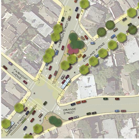
13 EXECUTIVE SUMMARY lines from their current route on Harrison Street to Oakland Avenue. Conversion of the one-way couplet streets north of the highway overpass creates the opportunity for improvements to Bayo Vista Avenue, currently a twolane, one-way street, to transition to two-way travel (one lane in each direction). In order to improve the issues associated with the complicated circulation pattern of the five-legged intersection of Harrison Street/24 th Street/27 th Street/Bay Place, the Conceptual Plan proposes a partial closure of 24 th Street to only allow for one-way, westbound travel from 27 th Street. The partial closure of 24 th Street and resulting reduction of this intersection from five legs to four would reduce the distance pedestrians would need to cross traffic and improve vehicle wait times. It would also provide for the opportunity to have a pedestrian plaza amenity at this intersection in close proximity to Downtown Oakland and development envisioned by the Broadway/Valdez Specific Plan area. In addition, the Conceptual Plan proposes to remove the channelized right turn onto 27 th Street from southbound Harrison Street. This proposal removes a potential conflict between pedestrians, bicyclists and vehicles, and replaces the channelized right turn with a new dedicated right turn lane and a corner pedestrian plaza with landscape features. In conjunction with the partial 24 th Street closure, these recommendations reduce crossing times for pedestrians and improve pedestrian open space. The proposed redesign of the 29 th Street/Fairmount Avenue/Oakland Avenue/Orange Street intersections is a major change at the heart of the Plan Area, which increases pedestrian safety and access while enhancing an existing open space amenity within the neighborhood. The Plan proposes to realign this intersection to make it more like a regular four-way intersection by closing the channelized right-turn lane onto Orange Street from northbound Harrison Street and constructing a large pedestrian bulb-out. The redesign of the intersection also proposes to reconfigure the existing landscaped median island on Harrison Street, to relocate AC Transit bus stops, to improve crosswalks, and to further study whether a traffic signal is warranted at this location. ix
14 EXECUTIVE SUMMARY The Conceptual Plan also recommends improvements throughout the Plan Area to improve the pedestrian experience and facilitate access including sidewalk repair, pedestrian lighting, ADA improvements, street trees and street furniture, and bicycle lane improvements. E. Issues Not Addressed by This Plan The goal of this Plan is to specify physical design solutions that would improve the safety and livability of the Plan Area. Some issues raised by the community during the planning process relate to programs and enforcement issues that could be addressed on a more immediate basis than the recommendations in this Plan. These issues are described in Chapter 4, and have been referred to the appropriate City department/agency. This Plan also does not address closure or modification of the on-/off-ramps of the Interstate 580 freeway. The idea of closing some or all of the freeway on- and off-ramps within the Plan Area was raised and discussed during the planning process. Closure and/or reconfiguration of the freeway on- and offramps would definitely be a very long-term process, requiring significant study of the regional freeway system, the preparation of an Environmental Impact Report, and many costly structural changes. One of the alternative design concepts presented to the community proposed reconfiguration and closure of the on- and off-ramps. While some workshop participants were interested in this idea, it was not selected as part of the preferred alternatives developed during the small group discussion portion of the workshop agenda. There was a lack of consensus on this issue. Some community members, while they supported the idea, felt that developing a Plan contingent upon the freeway on- and off-ramp closures might stand in the way of the further implementation of other solutions that could improve the safety and livability of their neighborhood. There were also community members who were very opposed to the freeway on- and off-ramp closure because they felt that the freeway was an amenity to their neighborhood and part of the reason that they chose to live there. Community members who lived in nearby neighborhoods that were also impacted by the freeway also voiced the con- x
15 EXECUTIVE SUMMARY cern that modification to the freeway on- and off-ramps in the Plan Area would adversely affect their neighborhood. This Plan does not recommend any freeway on- or off-ramp modifications. However, the recommended improvements in this Plan would not preclude any freeway on- or off-ramp modifications should the community, Caltrans and the City desire to study the question further in the future. F. Implementation The final chapter of the Plan includes a summary matrix of all the recommendations with information about agencies and other stakeholders who would have some role in implementation, preliminary cost estimates, and issues for future consideration. It also includes a discussion of potential funding sources. As noted at the outset of this planning process, no funding has been identified to date for any improvements recommended by this Plan. Further environmental review is needed before a number of recommendations can move forward. Because of this, the timing of implementation of various components of this Plan will vary. Different portions of the Plan may need to be advanced before others in order to be more competitive for a particular funding opportunity. Seeking funding will be more challenging since the Plan Area is not a redevelopment area or in proximity to a BART station or transit hub conditions for which funding opportunities are more available. Despite these circumstances, having a community-based plan is an important first step to becoming eligible for many sources of grant funding, to be considered by proposed Downtown development projects as part of their planning and environmental review process, as well as to be considered for City discretionary funding (when and if this becomes available in the future). This Plan also represents the first time that the entire length of Harrison Street and Oakland Avenue (from Grand Avenue to the Piedmont border) has been studied comprehensively for potential traffic calming and streetscape improvements. Implementing the recommendations of the Plan will require the xi
16 EXECUTIVE SUMMARY continued focused efforts of many, including neighbors, business owners, property owners, developers, volunteer organizations and the City, to secure grant funding, City funding and/or look for other opportunities provided by other development projects in the Plan Area vicinity that may be able to contribute towards the cost of certain recommendations. xii
17 1 INTRODUCTION A. Structure of the Report This planning process was comprised of four stages, culminating in the creation of a Preferred Concept Plan for the Plan Area. Each of these stages resulted in a number of memos, interim reports, and detailed transportation analysis that have been used to develop this report. These interim memos, reports and analyses are included as Appendices of this Plan: Appendix A: Harrison Street/Oakland Avenue CTP Existing Circulation Conditions Appendix B: Three Project Alternatives and the Harrison Street/ Oakland Avenue CTP Project Alternatives Memo Appendix C: Harrison Street/Oakland Avenue CTP Draft Concept Plan Memo and Appendices Appendix D: Transportation Analysis Appendices This document contains the following five chapters: Chapter 1 Introduction provides an overview of the planning process and the goals of the project. Chapter 2 Existing Conditions outlines the studies and analysis of the existing conditions of the Harrison Street/Oakland Avenue CTP Area. Chapter 3 Community Participation describes the community involvement in the planning process and describes the process for developing the preferred Concept Plan. Chapter 4 Plan Recommendations presents the recommendations and solutions that make up the preferred Conceptual Plan. Chapter 5 Implementation and Funding discusses the next steps required to implement Plan recommendations. Identifies the City departments and other community partners that would need to be involved and presents a range of potential funding sources. Appendices, as listed above. 1-1
18 INTRODUCTION B. Community Transportation Planning The Caltrans Office of Community Planning works to promote and participate in community based planning by funding the Community Based Transportation Planning (CBTP) grant program. CBTP grants are given to local communities to encourage planning that promotes efficient land use and transportation infrastructure investments, and helps communities to address their existing and future needs while maintaining community value and integrity. Caltrans, upon award, provides 80 percent (80%) of the planning cost, with the additional 20 percent (20%) provided by the local grantee. The City of Oakland, with support from numerous local community groups, applied for and received a grant to fund the Harrison Street/Oakland Avenue Community Transportation Plan. This Plan builds upon previous planning efforts initiated by the community to address traffic, safety and quality of life issues within the neighborhood. C. Purpose The goal of the Harrison Street/Oakland Avenue Community Transportation Plan ( the Plan ) is to work with a diverse group of stakeholders, including local residents, City staff and public agencies, to create a vision for calming traffic along Harrison Street and Oakland Avenue within the Plan Area, and to improve the livability of the neighborhood. The Plan creates a comprehensive and long-term vision for these two streets and surrounding area, including recommendations for capital improvements, conceptual estimated costs, and a discussion of next steps required to implement the Plan. D. Project Team and Advisory Committees The Project Team for this project included staff from Design, Community & Environment (DC&E) and Dowling Associates. DC&E was responsible for 1-2
19 INTRODUCTION community outreach and participation and developed the Plan designs. Dowling Associates performed traffic and circulation analysis of the existing conditions and proposed alternatives, and provided technical input on the designs. City of Oakland staff from the Strategic Planning Division coordinated the Technical Advisory Committee (TAC) and the Community Steering Committee (CSC). To ensure that the Plan is consistent with the needs of the community and standards of other agencies, a Community Steering Committee and a Technical Advisory Committee were formed to help guide the planning process. The committees were involved throughout the planning process to ensure that the proposed concepts and recommendations were feasible and consistent with the visions of the surrounding communities. The TAC was formed to provide input on technical issues regarding the existing conditions of the Plan Area and the feasibility of proposed recommendations, and help to prioritize the proposed projects. The TAC included members from public agencies such as AC Transit and Caltrans, as well as staff from the following departments of the City of Oakland Community and Economic Development Agency (CEDA): Engineering and Design Services, Transportation Services, and Strategic Planning. The CSC was formed to help represent the needs of the surrounding constituency and provide high-level guidance for the Plan. Members of the CSC included representatives from the following groups: Adams Point Action Council, City Council Districts 1, 2, and 3, HarriOak Neighborhood Association, Vista Neighborhood Association, Walk Oakland Bike Oakland (WOBO), Westlake Coalition, and Westlake Middle School. E. Planning Process The Harrison Street/Oakland Avenue Community Transportation Plan was developed over a 14-month period, from October of 2008 to December of The planning process was designed as collaboration between commu- 1-3
20 INTRODUCTION nity members, city staff and other public agencies. Over the course of the planning process the Project Team met with the TAC/CSC members five times, and hosted four Community Workshops. The planning process consisted of four stages: existing conditions analysis, conceptual alternatives development, preferred concept refinement, and final plan preparation. Throughout each of these stages the Project Team met with the TAC/CSC and held community workshops. The first stage of the planning process was the existing conditions analysis. During this stage the Project Team surveyed the site, and developed a detailed base drawing, to be used as a base map for the development of the proposals. During this stage the Project Team also reviewed previous planning efforts that included Harrison Street and Oakland Avenue, and discussed the findings with the TAC/CSC and the community. 1 The Project Team also met with the CSC and other community stakeholders to gain a better understanding of the communities concerns and issues regarding the Plan Area. The conceptual alternative development stage of the project included the development of three design alternatives for the Plan Area based upon the existing conditions and community input. The Project Team then analyzed the effects each of the conceptual alternatives would have on the traffic and circulation throughout the Plan Area. At the second community workshop three alternatives were presented to the TAC/CSC and the community. The workshop participants discussed the merits of each of the alternatives, and selected elements they preferred, resulting in the creation of a preferred design concept. Participants also engaged in an open discussion about the potential timeframe and feasibility of implementation of the different alternatives and how those topics influenced their choice of a preferred alternative. 1 Previous studies conducted on portions of Harrison Street and Oakland Avenue include a 1994 Dowling Associates study on the feasibility of a two-way conversion of the two streets north of MacArthur Blvd., as well as an MTC-funded Traffic Engineering Technical Assistance Program (TETAP) study to analyze traffic calming solutions along Harrison St. and Oakland Avenue between Grand Avenue and Interstate 580, conducted by Kimley-Horn and Associates (2007). 1-4
21 INTRODUCTION As part of the next stage, the preferred concept was presented to the TAC/CSC for review and comment, then slightly revised and presented to the community at a third Community Workshop. The Project Team refined the Preferred Design Concept based on community and City/Agency input. As Part of the final plan preparation stage, the Project Team conducted further analysis to understand the effects the Plan would have on the traffic, circulation and parking. In addition, the Plan identifies the next steps required to implement the Plan recommendations, including additional studies needed and potential funding sources to consider. 1-5
22 INTRODUCTION 1-6

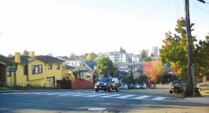
23 2 EXISTING CONDITIONS This chapter describes the Harrison Street/Oakland Avenue Community Transportation Plan (CTP) area and summarizes demographics, land use designation, urban design conditions, and traffic conditions within the Plan area. A. Plan Area Boundaries As shown in the Figure 2-1 below, the focus of the Harrison Street/Oakland Avenue Community Transportation Plan is an approximately 1-mile section of Harrison Street and Oakland Avenue from Grand Avenue, adjacent to Lake Merritt in Downtown Oakland, to Monte Vista Avenue at the border between the cities of Oakland and Piedmont. Harrison Street and Oakland Avenue run parallel to each other, spanning a very diverse transect of the City of Oakland. Figure 2-1 Plan Area Context 2-1

24 EXISTING CONDITIONS B. Neighborhood Overview To facilitate freeway access, Harrison Street and Oakland Avenue were converted in the 1960s into two, one-way arterials serving the freeway. Historically, Oakland Avenue was a wide, two-way boulevard with cable car service. When Oakland Avenue was converted to one-way, the street lost much of its character as the clearly defined, direct multimodal walking, bicycling and transit connector to and from Oakland s Downtown and Lake Merritt. Harrison Street, once a narrow, two-lane collector street, was widened south of the freeway to facilitate more traffic flow on the one-way southbound street to the Downtown. Harrison Street north of the freeway maintains its original width and some of the character it once had before the conversion. 1. Council Districts Harrison Street and Oakland Avenue are located within Oakland City Council Districts 1 and 3. City Council District 2 is adjacent to the Plan Area and residents of that District are affected by changes in the Plan Area. Figure 2-2 illustrates the location of the Plan Area with respect to the City s Council Districts. Figure 2-2 Council Districts 2-2
25 EXISTING CONDITIONS 2. Neighborhoods Interstate 580 is a barrier that divides the Plan Area into two distinct areas. Each area contains a number of active community groups. The area south of Interstate 580 is represented by a number of neighborhood associations, businesses and other community advocates that have come together as the Westlake Community Coalition. The Westlake Community Coalition includes the Harrison/Oakland Neighborhood Association (HarriOak), Westlake Middle School and First Congregational Church, among others. Residents north of Interstate 580 are primarily represented by the Vista Neighborhood Association and the Rose Garden Association. These community groups have been active in advocating for livability improvements along the Harrison Street and Oakland Avenue and have participated in previous planning efforts. 3. People The Harrison Street/Oakland Avenue neighborhoods are a mixture of singlefamily and multi-family dwellings. The Harrison Street/Oakland Avenue Plan Area is within five of the most densely populated census tracts in the City of Oakland. The relatively high densities make the investment in Plan Area improvements a priority for the City. The neighborhoods are also very diverse in household size, household type, age and race. Given the proximity to downtown, public transportation and Lake Merritt, the people living in the neighborhoods within the Plan Area are more apt to walk or take public transportation to take advantage of the many nearby amenities. This proximity to amenities and transportation makes the Plan Area attractive to seniors and has resulted in a fairly high concentration of senior housing and amenities. 4. Destinations Harrison Street and Oakland Avenue serve as important connections to destinations outside the Plan Area, such as Lake Merritt and the Downtown; they also provide access to a number of destinations inside the Plan Area that cater to the surrounding neighborhoods but attract a number of people to the 2-3


26 EXISTING CONDITIONS Plan Area from other parts of the Bay Area. Some of these key destinations are described below. Downtown Oakland attracts a number of employees and visitors daily due to the variety of office and retail businesses, restaurant and entertainment amenities as well as BART and AC Transit hubs. Downtown Oakland is also home for a number of people who live within its numerous apartments and condominiums. Lake Merritt First Congregational Church of Oakland Westlake Middle School The Cathedral of Christ the Light is a Catholic Church within the Oakland Diocese located at 180 Grand Avenue, on the corner of Grand Avenue and Harrison Street. The 224,000-square-foot cathedral was built in 2008 to replace the original cathedral at the same location which was destroyed by the 1989 Loma Prieta Earthquake. The large and iconic Cathedral is expected to receive 200,000 visitors annually. Lake Merritt is a tidal estuary that shapes Downtown Oakland and its surrounding neighborhoods. Recent improvements have rehabilitated the health of the lake and its aesthetics, making Lake Merritt an amenity for City residents. The lake is surrounded by parklands and a 3.5-mile path, used daily for walking, jogging and commuting. The Downtown Oakland Veterans Memorial Building is located at 200 Grand Avenue, on the Corner of Grand Avenue and Harrison Street. It houses the Downtown Oakland Multipurpose Senior Center. The Senior Center offers a number of social, recreational, health and educational services to Oakland Seniors. First Congregational Church of Oakland is located at 2501 Harrison Street, on the corner of the Bay Place, 24 th Street, 27 th Street and Harrison Street intersection. The church is a part of the United Church of Christ Congregation. The 124-year old building sits atop a slight hill and is an iconic landmark for this area of the City. The Church is an active member of the community and often provides their facility to outside organizations and community groups. Westlake Middle School located at 2629 Harrison Street, adjacent to the First Congregational Church, is part of the Oakland Unified School Dis- 2-4


27 EXISTING CONDITIONS trict. Approximately 600 students in grades six through eight come from all parts of Oakland. Students travel to school on foot, bicycle, bus, and by vehicle. Whole Foods Market, on the corner of Harrison Street and Bay Place, at 230 Bay Place, opened in September of The 55,000-square-foot store was designed and built with input from the community to meet their needs and to mitigate increased traffic and parking within the neighborhood. Morcom Rose Garden is located at the northeastern end of the Harrison Street/Oakland Avenue Plan Area. Since 1959, The City of Oakland s Parks and Recreation department has owned and maintained the 8-acre garden. The Rose Garden, between Oakland Avenue and Grand Avenue, is accessible from Oakland Avenue just north of Monte Vista Avenue. The garden contains many areas to sit and enjoy the variety of roses and is a treasured neighborhood asset. Morcom Rose Garden Plymouth United Church of Christ is located at 424 Monte Vista Avenue, on the corner of Oakland and Monte Vista avenues. The Church is part of the United Church of Christ Congregation and has been located in the present building since The church is also the location of a casual carpool pickup on weekday mornings. The City of Piedmont is the northeast border of the Plan Area. The City of Piedmont is a largely residential City with a population of approximately 11, Piedmont, which was incorporated in 1907, is surrounded by the City of Oakland. Many residents of Piedmont drive on Oakland Avenue and Harrison Street to gain access to and from the freeway, but also to the amenities of the area, such as Whole Foods grocery store. Piedmont Border 1 US Census,
28 EXISTING CONDITIONS C. Planning Context The City of Oakland has a number of documents that guide the planning and future development within the Plan Area and are applicable to this planning process. 1. Land Use and Transportation Element, City of Oakland General Plan 1998 This City of Oakland has a number of policies and plans which were developed to promote better pedestrian and bicycle environments, and are in support of the Complete Streets goals. The Land Use and Transportation Element (LUTE) of the Oakland General Plan (1998) contain a number of Objectives, Policies and Actions that promote better pedestrian and bicycle improvements and are in support of the goals of this Plan: Objective T4 Alternative Modes of Transportation. Increase use of alternative modes of transportation (LUTE, p. 58). Policy T4.6 Making Transportation Accessible for Everyone. Alternative modes of transportation should be accessible for all of Oakland s population. Including the elderly disabled and disadvantaged (LUTE, p. 58). Policy T4.10 Converting Underused Travel Lanes. Take advantage of existing transportation infrastructure and capacity that is underutilized. For example, where possible and desirable, convert underused travel lanes to bicycle or pedestrian paths or amenities (LUTE, p. 59). Objective T6 Safety. Make streets safe, pedestrian accessible, and attractive (LUTE, p. 60). Policy T6.2 Improving Streetscapes. The City should make efforts to improve the visual quality of streetscapes. Design of the streetscape, particularly in neighborhoods and commercial centers, should be pedestrian oriented and include lighting, directional signs, trees, benches, and other support facilities (LUTE, p. 60). 2-6
29 EXISTING CONDITIONS 2. Pedestrian Master Plan, City of Oakland General Plan (2002) The Pedestrian Master Plan (PMP) was developed as an outcome of Policy T4.5 of the Land Use and Transportation Element of the Oakland General Plan, which recommended the creation of Pedestrian Master Plan as a method to increase the use of alternative modes of transportation. The Pedestrian Master Plan outlines a series of policies and recommendations as a resource to promote pedestrian safety and access and improve the pedestrian environment. Some policies and actions of the Pedestrian Master Plan that are particularly applicable to this Planning process include: Policy 1.1 Crossing Safety. Improve pedestrian crossings in areas of high pedestrian activity where safety is an issue (PMP, p. 54). Action Consider the full range of design elements including bulbouts and refuge islands to improve pedestrian safety (PMP, p. 54). Policy 1.3 Sidewalk Safety. Strive to maintain a complete sidewalk network free of broken or missing sidewalks or curb ramps (PMP, p. 55). Policy 2.3 Safe Routes to Transit. Implement pedestrian improvements along major AC Transit lines and at BART stations to strengthen connections to transit (PMP, p. 57). Action Develop and implement street designs (like bus bulbouts) that improve pedestrian/bus connections (PMP, p. 57). PMP Policy 3.1 Streetscaping. Encourage the inclusion of street furniture, landscaping, and art in pedestrian improvement projects (PMP, p. 58). Action Include pedestrian-scale lighting in streetscape projects (PMP, p. 58). 3. Bicycle Master Plan, City of Oakland General Plan (2007) The Bicycle Master Plan (BMP) was developed as an outcome of Policy T4.5 of the Land Use and Transportation Element of the Oakland General Plan, which recommended the creation of a Bicycle Master Plan as a method to increase the use of alternative modes of transportation. The Bicycle Master Plan was originally written in 1999, and updated in The Bicycle Master 2-7
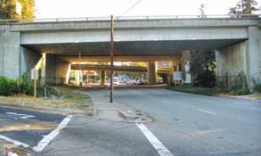
30 EXISTING CONDITIONS Plan outlines a series of policies and recommendations to create a bicycle friendly community and provide policies and recommendations to guide the accommodation of bicycles throughout Oakland. Some policies and actions of the Bicycle Master Plan that are particularly applicable to this Planning process include: BMP Policy 1A Bikeway Network. Develop and improve Oakland s bikeway network (BMP, p. 54). Action 1A.1 Bicycle Lanes (Class 2). Install bicycle lanes where feasible as the preferred bikeway type for all streets on the proposed bikeway network (except for the bicycle boulevards proposed for local streets with low traffic volumes and speeds) (BMP, p. 54). Action 1A.2 Arterial Bicycle Routes (Class 3A). Install arterial bicycle routes on collector and arterial streets only when bicycle lanes are infeasible. These shared lane facilities shall include best practices for lane widths, signage, and striping (BMP, p. 54). Action 1A.6 Dedicated Right Turn Lanes and Slip Turns. Where feasible, avoid the use of dedicated right turn lanes on streets included in the bikeway network. Where infeasible, consider a bicycle through lane to the left of the turn lane or a combined bicycle lane/right turn lane (BMP, p. 55). BMP Policy 1B Routine Accommodation. Address bicycle safety and access in the design and maintenance of all streets (BMP, p. 55). Action 1B.3 Freeway Ramps. Work with Caltrans to reduce conflicts created by ramps, dedicated turn lanes, and high-speed merges at freeway interchanges (BMP, p. 56). 2-8
31 EXISTING CONDITIONS D. Existing Circulation Conditions This section provides and overview of traffic, circulation and parking conditions in the Plan Area. More detailed information is provided in Appendix A. 1. Roadway Descriptions Roadways in the study Plan Area are classified and described as follows 2. Interstate 580 is an eight-lane east-west freeway that runs throughout the City of Oakland. This roadway crosses Harrison Street and Oakland Avenue in the Plan Area via overpasses. Harrison Street is a north-south arterial. In the Plan Area, Harrison Street operates as a two to three-lane southbound (one-way) couplet with Oakland Avenue from Bayo Vista Avenue to the Oakland Ave-Orange St-Fairmount Ave intersection, and as a four to six-lane roadway supporting two-way vehicular traffic to Grand Avenue. There are continuous sidewalks on both sides of the roadway, as well as a pedestrianized alley and three public staircases that intersect with Harrison Street. There are no bikeway facilities on Harrison Street in the Plan Area. Oakland Avenue is a two to three-lane north-south arterial that operates as the northbound section of a one-way couplet to Harrison Street from its origin at the junction with Harrison Street north to Bayo Vista Avenue, providing a direct connection to Interstate 580 from Downtown Oakland. North of Bayo Vista Avenue, Oakland Avenue operates as a two-lane arterial that supports two-way vehicular traffic, connecting the cities of Oakland and Piedmont. There are continuous sidewalks on both sides of the roadway as well as three public staircases that intersect Oakland Avenue. There are no bikeway facilities on Oakland Avenue in the Plan Area, other than a Class II bike lane, which was installed on 2 Roadway descriptions are based on the City of Oakland General Plan Envision Oakland City of Oakland General Plan: Land Use and Transportation Element, Volume 1. March And fieldwork performed by Dowling Associates. Figure 2-3 Plan Area 2-9
32 EXISTING CONDITIONS Oakland Avenue from 29 th process. Street to Perry Place during this planning MacArthur Boulevard-Santa Clara Avenue is an east-west arterial that runs approximately parallel to Interstate 580 throughout the City of Oakland, alternating between one-way and two-way operations. In the Plan Area, MacArthur Boulevard and Santa Clara Avenue converge to create a four-lane westbound (one-way) roadway that provides direct access from Interstate 580 and the local neighborhood, via MacArthur Boulevard and Santa Clara Avenue respectively, to Harrison Street and Oakland Avenue. Continuous sidewalks are located only on the north side of the roadway and there are no bikeway facilities. 27 th Street is a six-lane east-west arterial that provides access to Interstate 980 to the west of Harrison Street. At the intersection with Harrison Street, 27 th Street officially terminates and becomes Bay Place as it continues to the east. There are currently no bikeways but bike lanes and shared bike-motor vehicle lanes are planned for 27 th Street-Bay Place in the near future. Monte Vista Avenue is a two-lane two-way east-west local street that connects Harrison Street and Oakland Avenue to neighborhood commercial land uses on Piedmont Avenue. Monte Vista Avenue is also the northern terminus of Harrison Street. In the Plan Area there are continuous sidewalks on both sides of the roadway but no bikeway facilities. Bayo Vista Avenue is a two-lane westbound (one-way) arterial for a single city block, acting as the northern boundary of the Harrison Street- Oakland Avenue couplet. Bayo Vista Avenue continues as a two-lane, two-way, east-west local street to the west of Harrison Street. In the Plan Area there are continuous sidewalks on both sides of the roadway but no bikeway facilities. All other cross streets in the Plan Area are local streets with primarily residential land uses, as well as some small-scale commercial services. 2-10

33 EXISTING CONDITIONS 2. Average Daily Traffic Traffic counts were performed to estimate the average weekday daily traffic volumes and are reported in Table 2-1. Vehicle volumes on Harrison Street and Oakland Avenue were higher south of Interstate 580 than north of the freeway. The average Weekday Vehicle Daily Traffic is illustrated in Figure 2-4. TABLE 2-1 DAILY VEHICLE COUNTS SUMMARY Vehicle Volumes Count Location NB SB Total Harrison Street north of Moss Avenue N/A 6,929 6,929 Harrison Street/Oakland Avenue south of 29 th Street a 8,774 8,369 17,143 Harrison Street north of Hamilton Place (northbound only) 9,743 N/A 9,743 Oakland Avenue south of Pearl Street 9,748 N/A 9,748 Oakland Avenue south of Santa Rosa Avenue 8,139 N/A 8,139 Notes: NB = Northbound; SB = Southbound Tube counts conducted by National Data and Surveying Service (NDS) on Thursday, November 8, 2008 except Harrison Street/Oakland Avenue south of 29 th Street a Tube counts at Harrison Street/Oakland Avenue south of 29 th Street were collected for an entire week (January 22 through January 28, 2007) in both the northbound and southbound directions and provided to Dowling by the City of Oakland. The data summarized reflects the highest count day from the typical weekday period (Tuesday, Wednesday, and Thursday), which in this case was the Thursday. 3. Vehicle Speeds Vehicle speeds were collected at five locations. The posted speed limit on the two-way traffic segments of Harrison Street is 25 miles per hour. On Harrison Street just north of Westlake Middle School, there is a flashing beacon facing southbound traffic and signage facing both northbound and southbound traffic to indicate the presence of school children. Approaching this location, more than 40 percent of southbound traffic was traveling at or Figure 2-4 Average Weekday Daily Traffic 2-11
34 EXISTING CONDITIONS above 30 miles per hour. Additionally, 90 percent of northbound traffic at this location was traveling at or above 25 miles per hour and almost 60 percent was traveling at or above 30 miles per hour. Surveyed speed during hours that school children were likely present did not differ from other times of the day. Within the Plan Area, on average, 84 percent of northbound traffic was traveling at or above 25 miles per hour while 48 percent was traveling at or above 30 miles per hour. On average, 42 percent of southbound traffic was traveling at or above the posted speed limit of 30 miles per hour. 4. Intersection Level of Service Analysis To analyze intersection levels of service in the project area, this study used the Transportation Research Board's Highway Capacity Manual, 2000 method. Level of service (LOS) is a qualitative indication of the level of delay and congestion experienced by motorists using an intersection. Levels of service are designated by the letters A through F, which denote the average delay, with A having the best operating conditions and F the worst (high delay and congestion). Level of service criteria differ between signalized and unsignalized intersections. Existing level of service calculation results for the key Plan Area intersections are shown in Table 2-2. In the City of Oakland, the minimal acceptable Level of Service Standard for intersections outside of the downtown area in the City of Oakland is LOS D. Intersections operating below Oakland s standards are highlighted in the table. In addition to these results, operational issues were noted during field observations at Intersections 1 (Oakland Avenue and Monte Vista Avenue) and 2 (Harrison Street and Santa Clara Avenue- MacArthur Boulevard). At Intersection 1, casual carpools (informal locations where commuters heading into downtown San Francisco can pick up rides with random private motorists) operate in the morning peak-hour in the southbound direction on Oakland Avenue. The queue of vehicles waiting to pick up carpoolers was observed blocking the travel lane in numerous instances. At Intersection 2, vehicles heading southbound on Harrison Street 2-12
35 EXISTING CONDITIONS TABLE 2-2 INTERSECTION LEVELS OF SERVICE FOR EXISTING CONDITIONS AM Peak PM Peak Intersection Control LOS Delay LOS Delay 1. Oakland Ave and Monte Vista Ave AWSC C 22.2 D Harrison St and Santa Clara Ave/MacArthur Blvd Signal C 23.5 B Oakland Ave and Santa Clara Ave Signal B 12.2 B Harrison St and Stanley Pl/I-580 EB off-ramp SSSC D 25.0 B Oakland Ave and Perry Pl/I-580 EB ramps Signal C 23.8 F Harrison St and Pearl St Signal A 6.6 A Harrison St and 29 th St SSSC E 40.8 E Harrison St and Fairmount Ave/Orange St 9. Harrison St and Westlake Middle School driveway 10. Harrison St and 27 th St/ 24 th St/Bay Pl SSSC C 23.3 D 28.0 Signal A 4.8 A 4.4 Signal E 63.2 E Harrison St and Grand Ave Signal C 27.4 C Vernon St and Bay Pl Signal B 14.1 B Harrison St and Bayo Vista Ave a Custom A 9.0 A Oakland Ave and Bayo Vista Ave b UC N/A N/A N/A N/A Notes: AWSC = All-Way Stop Controlled Intersection; SSSC = Side-Street Stop Controlled Intersection; Signal = Signalized Intersection; LOS = Level of Service; EB = Eastbound. Delay is measured as seconds per vehicle. It refers to the weighted average delay at signalized and AWSC intersections and the weighted average delay of the intersection leg with the worst level of service at SSSC intersections. Uncontrolled intersections cannot be analyzed. Bold/italic = Intersections operating below Oakland s standards. Source: Calculated by Dowling Associates, Inc., in September 2009 using Synchro SoftwareTM Version 7 Build 773 Rev


36 EXISTING CONDITIONS during the morning peak-hour tended to favor the left-hand lane for Interstate 580 freeway access, leading to queues that frequently extended from Santa Clara Avenue to Bayo Vista Avenue in the left-hand lane, while the right-hand lane was comparatively empty. As a result, the queues in the left-hand lane were observed to build up faster than the traffic signal could serve. All intersections analyzed in the Plan Area currently operate above LOS D, which is the minimum level of service standard for intersections outside of the downtown area in the City of Oakland, except for the following: Intersection 5 Oakland Avenue and Perry Place/Interstate 580 ramps, which operates at LOS F in the PM peak hour Intersection 7 Harrison Street and 29 th Street, which operates at LOS E in the AM and PM peak-hours on the stop-controlled leg of eastbound 29 th Street. Intersection 10 Harrison Street and 27 th Street/24 th Sreet/Bay Place, which operates at LOS E in the AM and PM peak-hours. For ease of interpretation and analysis, level of service results for each study intersection are shown in Figure Existing Intersection Queues Additional analysis of the lengths of vehicle queues at each signalized study intersection was performed. To calculate vehicle queues, the 2000 Highway Capacity Manual s method was used. Peak-hour queues were calculated at signalized intersections using Synchro and compared to field observations to calibrate the model, as needed. Additional analysis of the existing 50 th and 95 th percentile 3 intersection queues are found in Appendix D. Figure 2-5 Existing Vehicle Intersection Level of Service 3 50 th percentile queues reflect average queuing length (half of the time the queue is shorter, the other half it s longer). 95 th percentile queues reflect the maxi- 2-14
37 EXISTING CONDITIONS It was found that the intersection of Harrison Street and 27 th Street/24 th Street/Bay Place has the most queuing capacity problems in both the AM and PM peak hours, especially in the southbound and northbound directions. Additionally, the intersection of Oakland Avenue and Interstate 580 eastbound ramps has queuing issues in the eastbound direction, most seriously in the PM peak-hour for the 50th percentile queue, which is not being served by existing signal timing. The intersection of Harrison Street and Santa Clara Avenue/MacArthur Boulevard has capacity issues for the 95th percentile in the westbound and southbound directions during the AM peak hour while Oakland Avenue and Santa Clara Avenue has capacity issues for the 95th percentile in the westbound direction in both the AM and PM peak hours. The intersection of Harrison Street and Grand Avenue has capacity issues in the southbound direction for the 95th percentile in both the AM and PM peak hours, as well as for the northbound right turn in the PM peak hour for the 95th percentile. The most serious queuing issues occur in the PM peak at intersection of Oakland Ave and the Interstate 580 eastbound on-ramps/perry Place for the eastbound Interstate 580 off-ramps, as the 50 th percentile queues do not appear to be served by the current signal phasing. Additionally, capacity problems are found for several movements of the intersection of Harrison Street/27 th Street/24 th Street/Bay Place in both the AM and PM peak hours. 6. Automobile On-Street Parking Inventory An inventory of existing, on-street parking facilities along Harrison Street and Oakland Avenue in the Plan Area was conducted in November The inventory included counting the number of curbside parking spaces, special curb markings (blue, white, and green zones), and parking restrictions. Since the parking spaces are not ticked, the parking spaces were counted using a standard measurement of twenty-two feet. Using this measurement means mum queue lengths 95 percent of the time, inversely 5 percent of the time this length is exceeded. Most jurisdictions use the 95 th percentile queues to design turning pocket lengths and to assess roadway storage capacity needed at intersections. 2-15
38 EXISTING CONDITIONS that in some instances an area that is used for parking, but is less then twentytwo feet long is not counted. However, this standard is necessary to estimate the number of parking spaces and has been used consistently throughout the Plan Area. Using this standard, it was estimated that there were a total of 325 general spaces, three green spaces (typically a 12-minute time limit), and three yellow spaces (loading zones for commercial vehicles during business hours). An occupancy evaluation of the on-street parking was not conducted because lack of availability of parking was identified as a problem by the community and stakeholders. The project assumed that parking was at capacity. 7. Roadway Crossings Although the distance between signalized intersections is generally long on Harrison Street/Oakland Avenue in the Plan Area, marked crosswalks are provided at reasonable frequencies for a pedestrian walking along this corridor, the striping is generally visible to vehicular traffic, and pedestrian ramps are often accessible at the crossing locations. However, no pedestrian ramps are equipped with truncated domes and in some instances residential driveways were observed to be presented as pedestrian ramps. Despite the frequency of marked crosswalks, crossing Harrison Street/ Oakland Avenue at any unsignalized location can be a daunting task for pedestrians, as observations found that vehicular traffic rarely acknowledged pedestrians waiting to cross at unsignalized locations. The most challenging unsignalized, crosswalk-equipped locations for pedestrians are as follows: Harrison Street/Oakland Avenue/Orange Street Fairmount Avenue. The most difficult unsignalized location for pedestrians to cross is the north leg of the Harrison Street/Oakland Avenue/Orange Street/ Fairmount Avenue intersection, where the roadway operation transitions between one and two-way vehicular traffic. Observations found that vehicle driver behavior was unpredictable at this location, specifically in variation in speeds between the lanes, as well as turning movements. Additionally, the roadway is relatively wide at this location, there is a slight eastbound grade, and the pedestrian ramp on the northeast corner (at the highest elevation for this intersection) is not aligned with the 2-16
39 EXISTING CONDITIONS crosswalk. Although there is a median, it is not equipped as a pedestrian refuge and the landscaping on the median south of the intersection creates a visual barrier between northbound vehicular traffic and eastbound pedestrian traffic. Harrison Street/Hamilton Place. The south leg of the Harrison Street/Hamilton Place intersection is also a difficult unsignalized location for pedestrians to cross, despite a flashing beacon and school crossing signage. This crossing location is approximately 250 feet south of the transition between one and two-way operations, the roadway is relatively wide at this location, and there is no street median. A curve in the roadway north of the marked crosswalk also creates a sight-distance issue for southbound vehicular traffic and pedestrian traffic in the western-most section of the crosswalk. Harrison Street/Stanley Place/Interstate 580 off-ramp. The west leg of the Harrison Street-Stanley Place/Interstate 580 eastbound off-ramp presents difficulties for pedestrians despite a stop-control for the eastbound vehicular traffic and a relatively short pedestrian crossing. Because conflicting vehicular traffic is only coming from the north (southbound on Harrison Street), eastbound drivers are prone to make the right turn without checking for northbound pedestrians at the south approach to the crosswalk. Harrison Street/Bayo Vista Avenue. The configuration of the intersection of Harrison Street with Bayo Vista Avenue (where the one-way couplet begins) creates an obstacle for pedestrians needing to travel to or from the southeast corner of this intersection. The land use on the east side of Harrison, south side of Bayo Vista, and west side of Oakland Avenue is primarily multi-family residential. Additionally, there are no mid-block pedestrian crossings on Bayo Vista Avenue and the southbound AC Transit local route 11 and Transbay Route P stop on the north side of Bayo Vista Avenue between Harrison Street and Oakland Avenue. Oakland Avenue/Bayo Vista Avenue. As was the case with the intersection of Harrison Street and Bayo Vista Avenue, the configuration of the 2-17

40 EXISTING CONDITIONS intersection of Oakland Avenue with Bayo Vista Avenue (where the oneway couplet begins) creates an obstacle for pedestrians needing to travel to or from the northwest corner of this intersection. The land use on the west side of Oakland Avenue, north side of Bayo Vista, and east side of Harrison is primarily multi-family residential and the AC Transit bus stops are located on the north side of Bayo Vista Avenue between Oakland Avenue and Harrison Street. 8. Pedestrian Counts Pedestrian counts in the Plan Area were also conducted at most of the same intersections where automobile turning movement counts were performed. The intersections with the highest pedestrian counts were: the Harrison Street/27 th Street/24 th Street/Bay Place intersection, the Vernon Street/Bay Place intersection, the Oakland Avenue/Monte Vista Intersection, and the Harrison Street/Oakland Avenue/Orange Street intersection. Peak hour intersection crossing counts are illustrated in Figure 2-6. Figure 2-6 Peak Hour Pedestrian Intersection Crossing Counts 9. Bicycle Circulation The City of Oakland s most recent Bicycle Master Plan (BMP) was adopted by the City Council on December 4, The document contains goals and policies, analysis of existing conditions, future bikeway network, prioritization of projects, and coordination with neighboring municipalities to provide a supportive bicycling environment. The City of Oakland uses bikeway classifications based as on Caltrans standards and described in the Bicycle Master Plan: Class I Bicycle Paths provide for bicycle travel on a paved right-of-way that is completely separated from the street. Class II Bicycle Lanes are striped lanes on streets, designated with specific signage and stencils, for the use of bicyclists. Class III Bicycle Routes designate preferred streets for bicycle travel using lanes shared with motor vehicles. Class IIIA Arterial Bicycle routes are routes used on some arterial streets where bicycle lanes are not feasible and parallel streets do not provide adequate connectivity. 2-18

41 EXISTING CONDITIONS Class IIIB Bicycle Boulevards are bicycle routes on residential streets that prioritize through trips for bicyclists. The BMP includes plans for a combination of Class II bike lanes and Class IIIA arterial bike routes on Harrison Street in the Plan Area. During the course of this planning process, Class II bike lanes have been implemented on Oakland Avenue between 29 th Street and Santa Clara Boulevard. Additionally, there are plans to complete the combination of Class II bike lanes and Class IIIA arterial bike routes on 27 th Street/Bay Place and install Class IIIB bicycle boulevards on Moss Avenue in the Plan Area. There are Class II bike lanes on Grand Avenue and around Lake Merritt and a combination of Class II bike lanes and Class IIIA arterial bike routes on 27 th Street. There are few public bicycle parking facilities in the Plan Area, with parking for two bicycles near the intersection of Oakland and Santa Clara Avenues and on Grand Avenue near Harrison Street. Bicyclist counts in the Plan Area were conducted at the same intersections where pedestrian counts were performed and are illustrated Figure 2-7. Bicycle volumes in the Plan Area were higher at the southern end of the Plan Area with the highest peak-hour volumes found at the Harrison Street/27 th Street/24 th Street/Bay Place intersection and the Vernon Street and Bay Place Intersection, during the weekdays, especially for the westbound approach. Also, wrong-way riding and/or sidewalk riding is somewhat common in the Plan Area, especially at the Oakland Avenue and Perry Place/Interstate 580 EB ramps intersection in the PM peak hour. Bicyclists also tend to ride in the wrong direction on Harrison Street because the grade is more gradual and easier to bicycle up than the grade on Oakland Avenue. 10. Bus Stop Routes and Facilities AC Transit operates bus routes on Harrison Street and Oakland Avenue in the Plan Area, as well as on the cross-streets of Santa Clara Avenue- MacArthur Boulevard and Grand Avenue. Routes 11 and P travel along Harrison Street and Oakland Avenue, Route 57 travel along Santa Clara Avenue- Figure 2-7 Peak Hour Bicycle Intersection Approach Counts 2-19

42 EXISTING CONDITIONS MacArthur Boulevard, and Routes 12, NL, and 805 travel along Grand Avenue. AC Transit provided passenger boarding and alighting data estimates for each bus stop in the Plan Area for a typical weekday. The data was collected over a period of several weeks and then summarized to represent a composite estimate of passenger activity. Figure 2-8 shows an estimate of daily weekday passenger boarding and alighting at each bus stop in the Plan Area, this information was provided by AC Transit. Passenger waiting facilities are found at some of the stops in the Plan Area. All stops are signposted with a placard containing the route number. On Harrison Street and Oakland Avenue, about half of the bus stops have benches. Shelters with benches are located at the Perkins Street stairway on Oakland Avenue and at the Vernon stairway across from Westlake Middle School (which does not serve as a bus stop). Most of the benches were located in the southern portion of the Plan Area. About a third of the bus stops contain route maps and schedules, and a number of bus stops have trash receptacles. Throughout the Plan Area, the majority of riders on AC transit Route 11 board in the southbound direction and alight in the northbound direction. The stops with the greatest rates of passenger boarding include the bus stop at the intersections of Oakland Avenue/Monte Vista Avenue, Harrison Street/ MacArthur Boulevard, Harrison Street/Pearl Street, Harrison Street/ Westlake Middle School and Harrison Street/Grand Avenue. The bus stops with the greatest rates of passenger alighting are at the intersections of Harrison Street/Hamilton Place, Harrison Street/Bay Place, Oakland Avenue/Bayo Vista Avenue, and Oakland Avenue/Monte Vista Avenue. Figure 2-8 AC Transit Weekday Passenger Boarding and Alighting Throughout the Plan Area, the majority of riders on AC transit Route P (transbay) board in the southbound direction and alight in the northbound direction. The stops with the greatest rates of passenger boarding are located at the intersections of Harrison Street/Moss Avenue and Harrison Street/ 2-20
43 EXISTING CONDITIONS MacArthur Boulevard. The stops with the greatest rates of passenger alighting are the stops near the intersections of Oakland Avenue/Monte Vista Avenue and Oakland Avenue/MacArthur Boulevard. 11. Collision Reports Collision reports for the Plan Area were obtained from the California Highway Patrol, which maintains the Statewide Integrated Traffic Records System (SWITRS) database. The five-year analysis included all reported collisions occurring from January 1, 2003 to December 31, 2007 on Harrison Street or Oakland Avenue in the Plan Area. During this time period, there were a total of 292 reported collisions in the Plan Area, distributed on the various segments of the Plan Area as follows: 103 on Harrison Street between Grand Avenue and Fairmount Avenue/Oakland Avenue (two-way vehicle operations) 96 on Harrison Street north of Fairmount Avenue/Oakland Avenue (predominantly southbound vehicle operations) 93 on Oakland Avenue (predominantly northbound vehicle operations) Overall, of the collisions, 4.1 percent of motor-vehicle collisions involved pedestrians, 2.7 percent involved bicycles, 11.6 percent involved parked vehicles, 6.9 percent involved fixed objects, and the remaining 74.7 percent involved motor vehicles only. E. Existing Urban Design Conditions 1. Topography The Harrison Street/Oakland Avenue Plan Area is in a unique geographic location within Oakland because it runs northeast from the flatlands of Downtown Oakland up to the Oakland/Piedmont hills. The length of the streets studied changes in elevation by approximately 150 feet. The neighborhood benefits from attractive views provided by the topography. However the topography also contributes to an unsafe pedestrian, bicyclist, and vehicular environment in the Plan Area. Topography on Oakland Avenue north of I

44 EXISTING CONDITIONS The elevation change is inconsistent along the two streets and results in a number of steep hills on both Harrison Street and Oakland Avenue. Harrison Street and Oakland Avenue are slightly curved and occasionally the bends in the road coincide with steep slopes, such as at the intersection of these streets with Hamilton Place and Moss Avenue. This condition creates poor visibility for pedestrians and vehicles and an unsafe situation. Steep topography can also contribute to accelerated speeds either up or down a steep slope. Traffic on MacArthur Boulevard during morning commute hours 2. Interstate 580 Interstate 580 was built in the 1960 s to facilitate interstate freeway travel and connect the San Francisco Bay Area to Interstate 5 in the Central Valley. The freeway bisects the Harrison Street/Oakland Avenue Plan Area and there are vehicle on- and off-ramps to Interstate 580 from both Harrison Street and Oakland Avenue. A further discussion of the effect of Interstate 580 on traffic occurs in the Existing Transportation Conditions Analysis. Interstate 580 has had significant impact on defining the boundaries of the adjacent neighborhoods and the urban design conditions in the Plan Area. Harrison Street and Oakland Avenue were converted from two-way streets to one-way arterials to facilitate access to the freeway. The conversion and freeway access introduced Harrison Street and Oakland Avenue to higher volumes of commuter traffic between Interstate 580 and Downtown Oakland. 3. Impact of Traffic on Plan Area Harrison Street and Oakland Avenue have speeding and vehicular congestion issues directly related to the freeway interchanges, its proximity to Downtown, and the surrounding topography. During commute hours, traffic is heavy within the neighborhood as residents from within the Plan Area and surrounding areas access the freeway entrances. A number of cars exit the freeway to gain access to Downtown Oakland. During commute hours, traffic often backs up within the neighborhoods as vehicles enter and exit the freeway. Freeway on- and off-ramps result in high speeds as cars accelerate to enter and exit the freeway at higher speeds appropriate for the freeway. 2-22
45 EXISTING CONDITIONS 4. Streetscape Quality Streets are a city s largest and most extensive public realm. They need to provide for all modes of transportation, including pedestrians, bicyclists, automobiles and transit services. The quality of the streetscape environment directly affects the experience of the user, and creating a positive pedestrian and bicyclist streetscape experience can encourage walking, bicycling and the use of transit. The quality of a streetscape is enhanced by the availability and upkeep of pedestrian features such as crosswalks and sidewalks, the existence and maintenance of street trees and landscaping, and the availability of lighting, street furniture and other pedestrian amenities. a. Street Trees The Harrison Street and Oakland Avenue street trees are planted in tree wells within the sidewalk, which are located between the pedestrian path of travel and the curb. Street trees help to define the pedestrian realm and delineate between areas for pedestrians and areas for bicycles and vehicles. The spacing of street trees is inconsistent along the Harrison Street and Oakland Avenue. Along Harrison Street south of 27 th Street/Bay Place there are a number of large mature sycamore trees, which create a nice pedestrian experience. Recently, near the Harrison Street and 27 th Street intersection a number of mature trees were cut down as a result of recent streetscape improvements associated with the new Whole Foods store. North of 27 th Street and below Interstate 580, the few trees that exist along Harrison Street and Oakland Avenue are, for the most part, healthy, mature street trees. However, some of the existing street trees have lifted the adjacent sidewalk. North of Interstate 580 on Harrison Street and Oakland Avenue, there are a number of sporadically planted street trees, which are a mixture of healthy, mature trees and smaller, more recently planted trees. In addition to the street trees, the Plan Area has a number of mature trees that are planted on private property that influence the streetscape environment and make up for the lack of and inconsistency of street trees. 2-23

. In many instances the sidewalks along the two streets are not ADA compliant.")
46 EXISTING CONDITIONS Sidewalk heaving as a result of tree roots b. Sidewalks Throughout the Project Area, the width and condition of the existing sidewalks vary. The sidewalks within the Plan Area vary from 4.5 feet to 15 feet wide. The Americans with Disabilities Act (ADA) standards for accessible design require that sidewalks are smooth, continuous and present no tripping hazards, and a minimum of 4 feet of unobstructed sidewalk (when there are unavoidable restrictions or barriers, clear width of travel may be reduced to 3 feet). In many instances the sidewalks along the two streets are not ADA compliant. Additional obstructions, consisting of utilities, signs and street trees, further narrow the existing sidewalk. Utilities (telephone and electrical wires) have been undergrounded on Harrison Street south of Orange Street. In many instances the sidewalks along the streets are cracked or heaved, creating tripping hazards. Throughout the Plan Area utility boxes within the sidewalk break up the visual quality of the sidewalks and create a precarious patchwork of concrete for pedestrians to maneuver around. As a result of the prevalence and density of housing, the continuity of the surface of the sidewalk is often broken to accommodate driveways. A number of these driveways are no longer used and create unnecessary disruptions to the continuity of the sidewalk surface. Curbcuts associated with unused driveways could be replaced to provide more on-street parking. The Harrison Street/Oakland Avenue CTP Existing Circulation Conditions attached in Appendix A contains a more extensive analysis of the sidewalks within the Plan Area. Landscape island maintained by local residents c. Landscape Features Given the residential character of the Harrison Street/Oakland Avenue Plan Area there is a significant variety in the type and quality of the landscaping along the two streets. In many instances, setbacks which would have traditionally been landscaped have been converted into car parking areas, especially along Harrison Street below the freeway. Upkeep and maintenance of the public landscape areas is diminished, in part because of the economic climate and under-funded maintenance division. 2-24
47 EXISTING CONDITIONS The landscape plantings and medians are often unkept, which contributes to a negative and unsafe perception of the public realm. As a result of the street pattern and the one-way conversion there are a number of landscaped islands within the Plan Area. Upkeep and maintenance of the public landscape is an issue in the Plan Area. Some are better maintained than others, in part due to the efforts of local residents. Other areas, such as the landscaped areas adjacent to, and underneath the freeway are overgrown, not maintained and accumulate trash, all of which contribute to making the area less attractive and feel unsafe. Throughout the Plan Area, there is also a lack of street furniture (e.g. benches), trash cans and bike racks, which would encourage pedestrians to stop and enjoy the public realm and foster community pride. d. Public Stairways The neighborhoods surrounding Harrison Street/Oakland Avenue were developed in the 1900 s as streetcar suburbs, with Oakland Avenue containing the main streetcar line. As a result, the street pattern surrounding Harrison Street and Oakland Avenue are not uniform and have many long blocks. The street pattern in the neighborhoods was developed to include a number of pedestrian paths and stairways which run perpendicular to Harrison Street and Oakland Avenue, providing pedestrian shortcuts to parallel streets as shown in Figure 2-9. Over the past few years people have rediscovered the value of these pathways and stairs and have begun re-investing in their upkeep and use. However, many of the paths and stairways are narrow, overgrown and lack public lighting. The paths and stairways need attention and maintenance to make them more safe and usable. e. Lighting The only lighting that exists on Harrison Street and Oakland Avenue are cobra head style street lighting. Cobra head lights are typically thirty feet tall and oriented to direct light onto the street below. This type of street lighting is designed to provide light for vehicles at night. Although street lighting tends to cast some light on sidewalks and other pedestrian areas, it typically Figure 2-9 Pedestrian Stairways 2-25


48 EXISTING CONDITIONS does not provide adequate lighting along sidewalks to make the pedestrian environment well-lit. Pedestrian scaled lighting is smaller, typically 12 to 16 feet tall and is used to provide light for sidewalks and other pedestrian areas. There are no pedestrian lights located along Harrison Street or Oakland Avenue, and the sidewalks tend to be dark during the evening. Well maintained residences along Harrison Street 5. Buildings and Facades Most of the buildings that front onto Harrison Street and Oakland Avenue are a mixture of single-family homes, single-family homes that have been converted to multiple units, and multi-family apartment buildings. The majority of the residential buildings along the streets are one- to three-story homes in a mixture of architectural styles, the most of which were built in the late 19th century or early 20th century. Much of the residential fabric along the streets are in good condition and show evidence of maintenance and care. There are a number of apartment buildings distributed throughout the Plan Area, especially concentrated on Oakland Avenue south of Interstate 580 and Oakland Avenue and Harrison Streets north of Interstate 580. The apartment buildings are three- to four-story buildings, which are typically located on what were originally two or three residential housing parcels. Most of the apartment buildings were built in the mid 20th century and have facades that are undistinguished with respect to a particular architectural style or character. Pedestrian experience is shaped by adjacent uses The pedestrian experience of the public sidewalk along Harrison Street and Oakland Avenue is shaped by the adjacent buildings and their facades. A public sidewalk is positively influenced by clear visibility from surrounding buildings and the existence of everyday neighborhood activity, which enlivens the environment. Unfortunately, the pedestrian experience is degraded in many locations because the visibility and the activity of adjacent buildings are hindered by adjacent blank walls or parked automobiles. In the case of residential buildings, there are several instances where the front yard or setback of a residential building has been replaced with either surface parking or garages. Similarly, in the case of apartment buildings, the ground floor is often entirely occupied by parking, which lacks windows or doors that would create visual transparency and/or activate an area. This lack of visibility and 2-26
49 EXISTING CONDITIONS activity adjacent to the public sidewalk makes the experience of the sidewalk feel isolated and unsafe. 2-27
50 EXISTING CONDITIONS 2-28
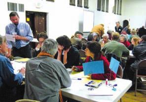
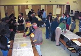
51 3 COMMUNITY PARTICIPATION The Harrison Street/Oakland Avenue Community Transportation Plan (CTP) is the culmination of a year-long planning process, which included extensive community involvement. This chapter describes the approach that was used for gathering community input and summarizes the communityidentified concerns. A. Community Outreach 1. Outreach Methods Multiple types of community outreach methods were employed to engage the community in the planning process. City of Oakland staff utilized their ties to the community from previous planning efforts to reach out to community groups and members who have been active in advocating for changes in the Plan Area. To invite community members to the public workshops, postcards advertising the Community Workshops were mailed to 400 households in the Plan Area. s advertising the Community Workshops were sent to local community members and neighborhood associations and other groups to forward to their members and advertise on their website. Additionally, flyers announcing the community workshops were distributed throughout the neighborhood by City staff and members of the Community Steering Committee. Finally, information regarding the planning process was regularly updated on the City of Oakland s Strategic Planning website: 2. Stakeholder Interviews In an effort to gain a better understanding of the community concerns and issues regarding Harrison Street and Oakland Avenue, the Design Team met with two groups of stakeholders. The stakeholders were members of local neighborhood associations and groups, active community members, and representatives from businesses and institution adjacent to Harrison Street and 3-1
52 COMMUNITY PARTICIPATION Oakland Avenue. The stakeholder groups identified and discussed specific areas of concern for the Plan Area, and how these issues affect the quality of life in the neighborhood. The stakeholder groups identified the following areas and issues of concern: 27th Street/ Bay Place and Harrison Street Intersection Bicycle Lanes along 27th Street/ Bay Place Vernon Street and Bay Place Intersection 24th Street/ Harrison Street Intersection Whole Foods Parking Lot Westlake Middle School and Driveway Access Hamilton Place and Harrison Street Intersection Orange Street/ Harrison Street/ Oakland Avenue Intersection Narrow travel lanes make it difficult for bicycles and vehicles to share the lane. Vehicles travel too fast on channelized right turn from Harrison Street to 27 th Street. There are long pedestrian crossings and wait times at the intersection and often people cross at unauthorized times. The traffic lights have poor timing, which contributes to congestion. Street trees that were removed as part of the Whole Foods development have not been replaced. The bicycle lane on Bay Place does not continue across Harrison Street to 27 th Street (the bike lane will be implemented in 2010). Vehicles making a right turn onto Harrison Street from Bay Place encroach into the bicycle lane. Vehicles do not stop at this intersection; drivers may not be accustomed to the new traffic light. The intersection is confusing and congested. Many drivers disregard the Right Turn Only sign when leaving the parking lot, and drive through the neighborhood. The driveway creates congestion on Harrison Street and 27 th Street because it is a one-way road that can only be accessed from northbound 27 th Street. The curvature of Harrison Street, in conjunction with the topography and narrowing of the street from three lanes to two, creates visibility problems at this location. The intersection is confusing for drivers, pedestrians and bicyclists, resulting in an unsafe environment. The medians are unattractive and hinder visibility. 3-2
53 COMMUNITY PARTICIPATION Oakland Avenue and 29th Street Intersection Interstate 580 Highway Underpass and Off/ On Ramp Areas MacArthur Street and Harrison Street/ Oakland Avenue Intersections Moss Avenue and Harrison Street/ Oakland Avenue Intersection Bayo Vista Avenue and Harrison Street/ Oakland Avenue Intersection Monte Vista Avenue and Harrison Street/ Oakland Avenue Intersection Fairmount Avenue/ MacArthur Boulevard/ Moss Avenue Intersection The marked crosswalks adjacent to this intersection have poor visibility. There is no bicycle access at this intersection. Vehicles entering and exiting the freeway travel through the neighborhood at high speeds. On- and off- ramp access is confusing and creates unsafe pedestrian and bicycle environments. The area under Interstate 580 is dark, dirty and feels unsafe. The lack of marked crosswalks and poor upkeep of existing marked crosswalks makes the pedestrian environment unsafe and circuitous. The curvature of Oakland Avenue and Harrison Street just above Moss Avenue creates a lack of visibility near this intersection. Vehicles travel through this intersection at high speeds because of the proximity to Interstate 580 on- and offramps and the topography. The roadway pavement is uneven. The channelized turn medians on Bayo Vista Avenue encourage drivers to drive too fast along Bayo Vista Avenue. Lack of marked crosswalks in conjunction with high speeds creates an unsafe pedestrian environment. The bus stop location creates a conflict between vehicles and buses that have to merge across two travel lanes. The lack of marked crosswalks makes it difficult for pedestrians to cross the street. Drivers ignore the 4-way stop sign. The traffic signals are difficult to see. The five-way intersection makes it difficult to turn onto Oakland Avenue from Moss Avenue. In addition to these above issues at specific locations, the stakeholders believe that both Harrison Street and Oakland Avenue are too wide with too many lanes, which in conjunction with undulating topography, encourages high 3-3

54 COMMUNITY PARTICIPATION vehicle speeds. The stakeholders felt there is a need for more trees and wider sidewalks throughout the Harrison Street/Oakland Avenue Plan Area to make the neighborhood more walkable. High speeds within the neighborhood affect the livability of the neighborhood and bicycle and pedestrian safety. Many of the existing sidewalks and marked crosswalks are not ADA accessible and are unsafe. In addition, cars are often parked too close to the intersection, obscuring pedestrian and vehicles visibility. The bus stops along Harrison Street and Oakland Avenue occur frequently which results in conflicts between buses and vehicles as the buses enter and exit traffic. The number of bus stops also detracts from available parking. The adjacent pedestrian paths are an amenity for the neighborhood but some feel the pathways are uncared for and unsafe. Additionally, the pedestrian paths do not align with marked crosswalks across either Harrison Street or Oakland Avenue, where it would seem that pedestrians naturally want to cross the street. B. Community Process This Plan is the result of an extensive outreach effort and four community workshops. The workshops were well attended and lively. A number of the meeting participants attended multiple workshops. The workshops were structured so participants could share their opinions and listen to the opinions of their neighbors. 1. Community Workshop #1: Issues and Opportunities On Thursday January 22, 2009, the first Community Workshop for the Harrison Street/Oakland Avenue CTP was held to review the existing conditions analysis of the Plan Area and discuss potential goals and visions for the project. Approximately 46 people attended the meeting. Community Meeting #1 John Hykes, DC&E Project Manager, gave a presentation on the existing conditions and the urban design context of the Plan Area. Kamala Parks, Dowling Associates, presented an overview of the circulation and traffic analysis performed along Harrison Street and Oakland Avenue. Meeting participants were then divided into small groups and asked to use the presented 3-4

55 COMMUNITY PARTICIPATION information to comment on significant areas of concern that they felt needed further elaboration, discuss potential improvements to the Plan Area, and prioritize what they thought were the most needed improvements. Each group was asked to report back to the large group. Community members were eager to express their concerns and share their first-hand observations regarding Harrison Street and Oakland Avenue. The participants of the small group exercise suggested potential improvements to the Plan Area and actively discussed and debated the benefits and drawbacks of the potential improvements. Participants were divided into five small groups of eight to ten people each. Community Meeting #1 The following improvements for the Plan Area were identified: Narrow Harrison Street and Oakland Avenue to two lanes throughout. Use the removed lanes for pedestrian and bicycle improvements. Harrison Street and Oakland Avenue should both be two-way streets south of Bayo Vista. In the long-term, consider closing at least some of the freeway on- and off-ramps and diverting traffic to other exits. Improve the timing of traffic signals. Encourage drivers to use 27 th Street to access the freeway instead of using the Harrison Street and Oakland Avenue. Change the speed limit to a consistent 25mph on both Oakland Avenue and Harrison Street north of Interstate 580. Incorporate speed limit signs, pavement legends and radar feedback signs to reduce speeding. Incorporate bicycle lanes/routes along the Harrison Street and Oakland Avenue. Street/Harrison Street/Oakland Ave- Improve the Intersection of 29 th nue/orange Street. Improve the safety and aesthetics the area under the Freeway. Consider new lighting and public art. 3-5

56 COMMUNITY PARTICIPATION Improve the visibility and safety of crosswalks throughout the Plan Area. Create a cut in the 27 th Street median to allow a left turn into the Church/School Parking lot from the eastbound direction. Incorporate diagonal parking along the Harrison Street and Oakland Avenue. Reassess bus stop locations throughout the Plan Area, and relocate them at safer locations. Especially the stop on Bayo Vista and on Oakland Avenue at Perkins Alley. Improve the safety and beautify the 27 th Street/Bay Place and Harrison Street intersection. 2. Community Workshop #2: Conceptual Alternatives Based upon the existing conditions analysis and the knowledge shared by City staff, the community members, CSC members and the stakeholder interviews, the Project Team developed three alternatives for the Plan Area. The Alternatives included, Alternative 1: Pedestrian Improvements, Alternative 2: Road Diet, and Alternative 3: Two-Way Conversion. Illustrations of these alternatives can be found in Appendix B. Community Meeting #2 The Pedestrian Improvements Alternative created pedestrian and bicycle amenities along Harrison Street and Oakland Avenue within the existing street right-of-way. In an effort to reduce speed and increase safety along the streets, the design concept added bulbouts to the side street intersections throughout the Plan Area. Bulbouts limit speeding by visually reducing the width of the travel lane at intersections where there may be incoming vehicles. Through widening the sidewalks at intersections, bulbouts increase pedestrian safety by reducing the crossing distance and increasing visibility. The Pedestrian Improvement Alternative also includes a two way conversion of Harrison Street and Oakland Avenue north of MacArthur Boulevard. The Road Diet Alternative narrowed the street right-of-way throughout the Plan Area resulting in cohesive two-lane, one-way streets. Removing the third lane on Harrison Street and Oakland Avenue utilized the additional 3-6
57 COMMUNITY PARTICIPATION right-of-way for a dedicated Class II bike lane along the entirety of Oakland Avenue and the length of Harrison Street south of Interstate 580. Additionally, as a result of changing the street curb-to-curb there is more right-of-way available to increase the sidewalk width throughout the Plan Area (except along Harrison Street north of Interstate 580). The redesign of the 29 th Street/Fairmount Avenue/Oakland Avenue/Orange Avenue intersections increases pedestrian safety and access and creates room for a new open space amenity within the neighborhood. The Two-Way Conversion Alternative converted Harrison Street and Oakland Avenue from one-way to two-way along their entirety. South of Interstate 580 Harrison Street is converted into a two-way street with a dedicated center turn lane and no bike lanes, and Oakland Avenue is re-designed as a two-way street with sharrow lanes for bicycles in both directions. North of Interstate 580 Harrison Street is converted to a two-way street, with no capacity for any bicycle amenities or sidewalk widening, and Oakland Avenue is designed with a dedicated Class II bicycle lane in the northbound direction and a sharrow lane for the southbound. The Two-Way Conversion Alternative requires a re-design of the 29 th Street/Fairmount Avenue/Oakland Avenue/Orange Avenue intersections as a signalized T intersection. The conversion also requires a re-organization of the on- and off-ramps for Interstate 580, including a closure of the Interstate 580 on-ramp from Oakland Avenue and the addition of a new on-ramp to Interstate 580 from Harrison Street. On Thursday April 23, 2009, the second Community Workshop for the Harrison Street/Oakland Avenue CTP was held to review and discuss the proposed alternatives. John Hykes, DC&E Project Manager, gave a visual presentation of the three alternatives developed for the Harrison Street/Oakland Avenue Plan Area. Kamala Parks, Dowling Associates, presented a traffic analysis of the alternatives. The meeting participants were then divided into small groups and asked to discuss the three alternatives. The groups were then asked to compare the three alternatives at four specific geographic locations and vote for which alternative they preferred at each location. Group 3-7

58 COMMUNITY PARTICIPATION members were encouraged to draw or write any comments, caveats or ideas on the maps. Approximately 33 people attended the meeting. Community Meeting #2 Community participants actively discussed the three alternatives and their potential benefits and drawbacks. They also shared their opinions about why they preferred one alternative to another and made efforts to understand each others opinions. Participants were divided into four small groups of eight to ten people each. The following is a brief synopsis of the groups prioritization of the three alternatives and issues/ideas each felt were important reasons for the choices. Harrison Street/24 th Street/27 th Street/Bay Place. For this intersection a slight majority of the participants choose Alternative 2, which includes the partial closure of 24 th street and removing the channelized right turn lane onto 27 th from Harrison Street. There was disagreement in terms of the closure of 24 th Street; a number of participants supported a full closure. Additionally, a number of participants were opposed to the removal of the slip-turn lane onto 27 th Street, and felt that the removal would increase congestion on Harrison Street. Harrison Street/Oakland Avenue/Fairmount Avenue/Orange Street/29 th Street. For the area surrounding this intersection the majority of the participants choose Alternative 2 and 3. Nearly all of the participants supported the closure of the slip-turn from Harrison Street onto Orange Street. The majority of supporters of Alternative 2 felt that the reorganization of the intersection was an improvement, but that the 29 th Street couplet should be kept open to prevent U-turns at the Fairmount intersection. A number of participants supported Alternative 3 because they felt that the inclusion of a new traffic signal near this intersection would help to mitigate speeding and pedestrian safety problems which currently exist at this location. Participants, who supported both alternatives, suggested the addition of flashing lights to alert vehicles of the presence of pedestrians. Harrison Street/Oakland Avenue Couplet South of Interstate 580. The majority of the participants chose Alternative 2 for this area because they 3-8

59 COMMUNITY PARTICIPATION approved of the lane reduction and supported the increase of bike and pedestrian facilities. However, many participants choose this alternative with the caveat that they did not support the closure of Santa Clara Avenue, west of Harrison Street. One of the main reasons the group chose this alternative over Alternative 3, which is a two-way conversion, is because they felt that it was more achievable in that it was something that could be implemented in some manner in a shorter time frame. A number of participants still supported investigating the possibility of closing some of the Interstate 580 on- or off-ramps. However, other participants did not support the closure of any on- or off-ramps because they felt that freeway access was an amenity to their neighborhood. Harrison Street/Oakland Avenue Couplet North of Interstate 580. For this area the majority of the workshop participants choose Alternative 1 and 3, because they supported the conversion of Harrison Street and Oakland Avenue to two-way streets, which was incorporated in both designs. Many participants noted that they felt that Oakland Avenue was a better street for AC Transit, and were pleased that the conversion allowed Bayo Vista Avenue to be converted to a two-way street without the triangle channelized right turn medians at the intersections. 3. Community Workshop #3: Draft Preferred Concept Based upon the community input at the second Community Workshop, and input from the City of Oakland staff, agency staff, and the TAC and CSC, the Project Team developed a Draft Preferred Concept for the Plan Area. The Draft Preferred Concept was developed primarily from Alternative 2: Road Diet, which proposed a reduction from three to two travel lanes on Harrison and Oakland. The concept also includes a two-way conversion of Harrison Street and Oakland Avenue north of Interstate 580 as proposed in Alternatives 1 and 3. The Draft Preferred Concept also included infrastructure changes for pedestrians and lane reconfigurations for vehicle operations and aesthetic amenities such as new street trees, pedestrian street lights, street furniture and other street character improvements. Community Meeting #3 3-9
60 COMMUNITY PARTICIPATION On Thursday July 23, 2009, the Third Community Workshop for the Harrison Street/Oakland Avenue CTP was held to review and discuss the Draft Preferred Concept. Approximately 34 community members attended the meeting. John Hykes, DC&E Project Manager, gave a visual presentation of the Draft Preferred Concept developed for the Harrison Street/Oakland Avenue Plan Area. Kamala Parks of Dowling Associates presented a traffic analysis of the alternative. The meeting participants were then divided into small group study sessions to discuss the alternative and then returned for a larger group discussion of the issues identified by the groups. In summary, the majority of the community members in attendance supported the project s concept ideas, and confirmed that the design was headed in the right direction. Harrison Street/24 th Street/27 th Street/Bay Place. There was disagreement regarding which of the proposed alternative improvements would be better for this intersection. There was consensus that the proposed limited closure of 24 th Street is a good idea, but there are concerns that the partial closure of 24 th Street may cause blight, which needs to be addressed. The participants were split in their support for changes to the 27 th Street channelized turn. Opponents to the removal of the channelized turn were worried that the removal may cause an increase in traffic queuing. Supporters removing the channelized turn felt the removal would greatly improve the safety of bicycles and pedestrians at this location. Representatives from the Westlake middle School strongly advocated for the removal of the channelized turn to better facilitate student crossings and safety. Harrison Street/Oakland Avenue/Fairmount Avenue/Orange Street/29 th Street. The community members felt the reconfiguration of the Fairmount Avenue and Orange Street intersection was a good proposal. However, overall participants felt this intersection warrants a traffic signal in addition to the proposals recommended. Harrison Street/Oakland Avenue Couplet South of Interstate 580. The majority of community members support a road diet to reduce the travel 3-10
61 COMMUNITY PARTICIPATION lanes from three to two on both Harrison Street and Oakland Avenue where feasible. There was a lack of consensus regarding the proposal to close eastbound Santa Clara, as it will have an impact on the surrounding neighborhoods diverting some traffic onto other streets. Although many community members have discussed and proposed the closure of several on-off ramps in the immediate area as a separate study from this project, the majority of the community members present at the community meetings are opposed to the concept stating that access to the highway is part of the appeal of the neighborhood. There was strong support for the proposed pedestrian stairs at Stanley Place. Harrison Street/Oakland Avenue Couplet North of Interstate 580. While many community members support the idea of the two way conversion of Harrison Street and Oakland Avenue north of Interstate 580, many participants were concerned about the two way conversion increasing congestion in the neighborhood and surrounding areas. Some participants were also concerned with the potential relocation of the bus routes; however there was overwhelming support for the re-design of Bayo Vista Avenue and the relocation of the bus stop on Bayo Vista. Concern was also expressed regarding the visibility of some proposed marked crosswalks associated with the two way conversion. 4. Community Workshop #4: Draft Plan Review Based upon the feedback on the Draft Preferred Concept received from the community at the third community workshop, the TAC and CSC, and the City of Oakland staff, the Project Team finalized the Conceptual Plan for the Plan Area and prepared the Public Review Draft Harrison Street/Oakland Avenue Community Transportation Plan. The community generally supported the proposed Plan overall. Two aspects of the Draft Preferred Concept were changed as part of Public Review Draft Plan. The proposal to close access to Harrison Street via eastbound Santa Clara was removed from the Plan based upon the lack of consensus during the community workshop and opposition from the Richmond Boulevard Neighborhood. Similarly, during the third workshop there was also a lack of 3-11
62 COMMUNITY PARTICIPATION consensus regarding whether to remove or modify the Harrison Street channelized right turn lane at the intersection of Harrison Street/27th Street/24th Street/Bay Place. Traffic analysis of the two design options for this intersection found that the two proposals varied minimally. The level of delay and congestion experienced by motorists was almost identical for both proposals, and the signal timing, which influences the pedestrian wait times, differed only slightly. Based upon traffic analysis results that the two proposals varied minimally from an operational standpoint, and on the strong support of Westlake Middle School and pedestrian and bicycle advocates, only removal of the Harrison Street channelized right turn lane was put forth as a recommendation in the Public Review Draft Plan. On Thursday, December 3, 2009, the fourth Community Workshop for the Harrison Street/Oakland Avenue CTP was held to review and discuss the Draft Plan. Prior to the meeting, on November 23, 2009, a Public Review Draft of the Plan was made available on the City s website so the public would have an opportunity to review the Plan document before the meeting. Approximately 21 community members attended the meeting. John Hykes, DC&E Project Manager, gave a visual presentation of the revisions to the Concept Plan and outlined the format and substance of the Plan document. Kamala Parks of Dowling Associates presented a traffic analysis of the finalized Concept Plan. The meeting participants had an opportunity to ask questions and discuss the Conceptual Plan and the Plan document. Community members participated in a prioritization exercise where there were asked to select three of the Plan recommendations they considered were the most important. Community members were also given the opportunity to provide written feed back regarding the Plan on comment cards at the meeting. Revisions were made to the Final Plan based on the community s input. 3-12
63 4 PLAN RECOMMENDATIONS The Conceptual Plan for Harrison Street and Oakland Avenue was developed from input received from the Technical Advisory Committee, the Community Steering Committee and the Community Meetings. This chapter describes the components of the Conceptual Plan and provides an overview of the circulation and parking analysis conducted on the Plan. A. Conceptual Plan Recommendations The Conceptual Plan proposes a reduction of three one-way travel lanes to two one-way travel lanes on Harrison Street and Oakland Avenue south of Interstate 580, and a two-way conversion of Harrison Street and Oakland Avenue north of Interstate 580. The Conceptual Plan illustrated in the figures found at the end of this chapter and described below, graphically represents the infrastructure changes for pedestrians, lane reconfigurations for vehicle operations, and amenities such as new street trees, pedestrian street lights, street furniture and street character improvements. While the Harrison Street/Oakland Avenue CTP is a conceptual plan, signs, lighting, and pavement markings (words, crosswalks, bike lanes, and bike symbols) are shown and referenced on the drawings. This is to reinforce the plan s intention to create a roadway environment that addresses the needs of pedestrians, bicyclists, transit passengers, and motorists, as per the California Complete Streets Act. As elements of the plan progress to construction designs, the installation and placement of signs, lights and pavement markings will be evaluated in greater detail using the California Manual on Uniform Traffic Control Devices (CA-MUTCD), the Highway Design Manual, FHWA s Safety Effects of Marked Versus Unmarked Crosswalks at Uncontrolled Locations Final Report, Site Line Distance Analysis, and Recommended Guidelines, and City of Oakland standards. Additionally, all proposed bulbouts will require further study for traffic operations and safety analysis before implementation. 4-1
64 PLAN RECOMMENDATIONS 1. Travel Lane Reduction The Conceptual Plan proposes reducing Harrison Street and Oakland Avenue south of Interstate 580 from three lanes to two lanes resulting in a cohesive system comprised of two-lane, one-way directional streets. This change entails only a reconfiguration of the sidewalks and travel lanes and does not propose any changes to the existing right-of-way. Removing the third lane on Harrison Street and Oakland Avenue utilizes the additional right-of-way for a dedicated Class II bike lane along Oakland Avenue from the intersection with Fairmount Avenue to Monte Vista Avenue and on Harrison Street from the intersection with Fairmount Avenue to Interstate 580. Harrison Street Sidewalk Widening and Bulbouts. As a result of narrowing Harrison Street from three lanes to two lanes, there is more rightof-way available to increase the sidewalk width along Harrison Street throughout the Plan Area. Harrison Street in the area between Interstate 580 and the intersection of Oakland Avenue allows for the most consistent sidewalk widening. Widening the sidewalk would create space for more pedestrian amenities, street trees and landscaping. Implementation of the widened sidewalk could be done as a phased approach, allowing for re-striping of the travel lanes and bike lane in the interim. Sidewalk widening includes the removal of the existing curb and gutter and the relocation of storm drain inlets adjacent to the existing curbs and gutters. The costs associated with sidewalk widening are expensive and as a result the recommendation is to consolidate the available right-of-way and widen the sidewalk on one side of the street, rather than both sides of the street. The western side of the street is widened because it is the side which continues through beyond the freeway underpass and the pedestrian path of travel requires fewer crossings. Bulbouts are consistently included at the intersections along Harrison Street south of Interstate 580. The new bulbouts at the Intersection of 29 th Street, Garland Avenue, Frisbie Street and Pearl Street all shorten the pedestrian crossing distance and increase the visibility of pedestrians. Not all side streets have been analyzed for adequate turning radius, and would need further analysis before implementation. 4-2
65 PLAN RECOMMENDATIONS Oakland Avenue Sidewalk Widening and Bulbouts. Converting Oakland Avenue south of Interstate 580 from three lanes to two lanes allows the sidewalk to be widened on the east side of the street from approximately 200 feet north of Perkins Walk to Perry Place. The Oakland Avenue and Pearl Street intersection is improved by creating a new pedestrian bulbout on the southern side of the intersection, which helps with the lane realignment and improves the pedestrian crossing at Pearl Street. Additionally, the bulbout helps to protect vehicles turning left from Pearl Street onto Oakland Avenue, essentially marking the transition from two travel lanes to three travel lanes at the approach to the Interstate 580 on-ramps. 2. South of Interstate 580 Specific design interventions for the Conceptual Plan Area include the following: Grand Avenue Intersection Improvements. The addition of a new bulbout on the northwest corner of the intersection of Harrison Street and Grand Avenue would shorten the distance of the Harrison Street crosswalk and improve the visibility of pedestrians at the intersection. The southbound bus stop at Grand Avenue/Harrison Street is re-located to the far side of the intersection in front of the new cathedral. A new bus shelter is recommended at this location, provided that the shelter placement does not block the windows of the adjacent Cathedral of Christ the Light. 23 rd Street Crossing. The addition of bulbouts to the existing crossing of Harrison Street at 23 rd Street will shorten the distance of the marked crosswalk and improve visibility for pedestrians using this crossing. As part of the recommendation the marked crosswalk is moved approximately 10 to the north to accommodate the creation of a pedestrian refuge island aligned with the existing center median. A crosswalk is marked in this location to access the Senior Center within the Downtown Oakland Veterans Memorial Building on the east side of Harrison Street at 23 rd Street. The recommended improvements would increase 4-3
66 PLAN RECOMMENDATIONS the safety for pedestrians and drivers at a location that is highly used by senior citizens. Harrison Street/27 th Street/24 th Street/Bay Place Intersection Improvements. The changes to the Harrison Street/27 th Street/24 th Street/Bay Place intersection will improve the pedestrian and bicycle safety at the intersection and shorten the signal cycle lengths, which will improve the delay for vehicles at the intersection. 24 th Street Access Changes. Closing 24 th Street to only allow access westbound from 27 th Street reduces the vehicular movements allowed at the 27 th Street/Bay Place and Harrison Street intersection, essentially reducing the 5-legged intersection to a 4-legged intersection. The closure facilitates better pedestrian access; additional signal adjustments would improve crossing times for both pedestrians and vehicles. The right-ofway gained by the closure provides an opportunity for a large pedestrian plaza, maintains the existing westbound access to local businesses, and provides the potential for diagonal parking on 24 th Street. Further study will need to be done in order to implement this idea including, notification/outreach to surrounding businesses and residents, consultation with the Oakland Fire Department regarding access, and ultimately City Council action to close the street. Additionally, this partial closure should be further studied as part of the Broadway/Valdez District Specific Plan. Harrison Street/27 th Street Channelized Right Turn Removal. This intersection was targeted for improvement with the goal of reducing the signal cycle length and reducing the amount of time it takes for the pedestrian to cross the intersection. Many workshop participants favored modification of the channelized right turn lane rather than complete removal. However, the CSC representatives of both the Westlake Middle School and Walk Oakland Bike Oakland were strongly supportive of the channelized right turn lane removal. The removal of the channelized right turn lane entails the removal of the existing pork chop pedestrian island and widening Harrison Street to provide a dedicated right-turn lane. It creates a pedestrian plaza with land- 4-4
67 PLAN RECOMMENDATIONS scaping on the northwest corner and reduces the number of legs for pedestrians to cross, as well as controls the right-turn movements. It also increases the pedestrian crossing distances at the intersection by 20 feet on the northern leg and by 6 feet on the western leg, which means 5 and 2 more seconds, respectively, needed for pedestrians to clear the crosswalks. The intent is to remove the potential conflict between pedestrians, bicycles and vehicles that occurs when vehicles are allowed to make a free right turn. This design also potentially creates a situation where trucks turning right from Harrison Street onto 27 th Street need to encroach upon one or more adjacent travel lanes to complete the maneuver, and further study will need to be performed to ensure that this design meets all the necessary requirements for truck turning radii. 27 th Street Lane Configuration. At this intersection on eastbound 27 th Street, the Plan proposes changing the lane configuration of the intersection from one left turn lane, two thru lanes, and one right turn lane to two left turn lanes, one thru lane and one right turn lane, in order to accommodate the vehicle volumes that are present. The proposed lane configuration changes, in conjunction with the proposed reconfiguration of the intersection from five legs to four, will reduce the existing congestion and confusion associated with this area. Traffic Analysis supports the recommendations of the proposed two left turns at this location, however further analysis will be required with future design development. Bay Place and Vernon Street Pedestrian Crossing Improvements. The addition of a bulbout on the south side of the Bay Place Crosswalk and the extension of the newly improved sidewalk on the north side of the crosswalk at Vernon Street shortens the pedestrian crossing distances and allows for improved signal timing at both this intersection and the Harrison Street/Bay Play/27 th Street intersection. Westlake Middle School Area Improvements. Internal parking lot and access operations for the school impact the pedestrian and traffic operations on Harrison Street and 27 th Street. Investigation of and proposals for the reconfiguration of private property were outside the scope of this 4-5
68 PLAN RECOMMENDATIONS project. The following recommendations are proposals to help address some of the issues that impact the school. Improved Access to Interior Parking Lots. Creating a break in the existing median island provides access from southeast bound traffic on 27 th Street across traffic to the combined church and school parking lots. This improvement is supported by Westlake Middle School and the First Congregational Church of Oakland and would help to alleviate southbound congestion on Harrison Street at the 27 th Street/Bay Place intersection. Northbound Bus Stop. Relocation of the bus stop at Hamilton Place, which suffers from poor visibility, to a new location across from the Westlake Middle School, includes the extension of the recently installed bulbout to create a bus bulbout, which would facilitate bus boarding and alighting and provides a more direct route for students traveling to school on the bus. Southbound Bus Stop. A new bus shelter is proposed for the southbound bus stop in front of Westlake Middle School because this is a location with a high amount of bus boarding. A minimum of 12 feet of sidewalk is required to allow for the bus shelter minimum ADA sidewalk clearance. In order to place a bus shelter at this location it may be necessary to obtain encroachment permit from the Oakland Unified School District, to locate the bus shelter at the back of the walk on OUSD property. Hamilton Place. The intersection of Hamilton Place and Harrison Street has limited visibility because north of the intersection Harrison Street is curved and steep, which limits the sight lines. The removal of the southbound bus stop at Hamilton Place and the relocation of the northbound bus stop to closer to the Westlake Middle school would lessen the amount of pedestrian activity that is concentrated at this intersection. Additionally, relocating the marked crosswalk would encourage pedestrians to cross Harrison Street at other, more visible and safe locations. 4-6
69 PLAN RECOMMENDATIONS Fairmount Avenue/Orange Street/Harrison Street/Oakland Avenue Intersection Realignment. Realignment of the intersection, creation of bidirectional turning movements and the inclusion of new bus bulbouts would improve traffic operations at this location. Additionally, pedestrian actuated warning beacons would be installed in advance of this intersection in either direction to warn drivers of the pedestrians using the upcoming crosswalks. The turn-around couplet at 29 th Street is maintained to reduce the potential for U-turns at the Fairmount Avenue/Orange Street intersection. As part of further design development, the existing turning radius at the intersection of Harrison Street and 29 th Street should be reviewed to determine if there is the potential for the sidewalk to be widened for pedestrians and the intersection turning radius to be reduced to lower speeds of vehicles making this left turn. Landscaped Median Island. Widening and shortening the existing landscaped median island on Harrison Street (north of the Fairmont Avenue/Orange Avenue Intersection) would improve the crosswalk from Fairmount Avenue to Orange Avenue by providing a pedestrian refuge island. Additionally, relocating and extending the existing smaller median island (south of the Fairmount Avenue/Orange Street Intersection) allows for a pedestrian crossing with a pedestrian refuge. The modifications to the islands help to straighten out a previously curved intersection, which would increase visibility for drivers. The modified islands also create a dedicated left-turn turn lane, eliminating congestion caused by left turns. Re-location of Marked Crosswalks. Presently the marked crosswalks near this intersection are located on Oakland Avenue just north of the 29 th Street couplet, on Harrison Street on the north side of the Fairmount Intersection,. In conjunction with the other recommendations, the plan would remove the marked crosswalk on Oakland north of the 29 th street couplet because it has poor visibility and is associated with the relocated bus stop. The marked crosswalk on Harrison Street on the north side of the Fairmount intersection would remain, with the addition of a new marked crosswalk on the south side of the intersection in conjunction with a median pedestrian refuge and intersection bulbouts. New marked 4-7
70 PLAN RECOMMENDATIONS crosswalks would be added on the east and west side of the 29 th Street couplet to allow pedestrians access to the newly designed median island The existing crosswalk on Harrison Street on the north side of the 29 th Street intersection remains in the current location with the addition of a bulbout on the west side of the street for improved visibility. Re-location of Bus Stops. The existing southbound and northbound bus stops located at 29 th Street are proposed to be relocated to the bus bulbouts at the newly configured Fairmount Avenue and Harrison Street intersection. This relocation improves rider safety by locating the stops closer to the reorganized intersection with new pedestrian crosswalks. The relocation of AC Transit stops to this intersection and the inclusion of bus bulbouts, helps to both activate the intersection and decrease the crossing distance, making the intersections easier and safer for pedestrians. Potential Traffic Signal. The community and City of Oakland staff have expressed support for a traffic signal at the intersection of Harrison Street-Fairmount Avenue-Orange Street, which is currently side-street stop-controlled. Dowling Associates performed a peak-hour vehicle volume analysis at this intersection and found that a traffic signal did not satisfy the peak-hour warrant under existing or 2035 conditions. It will require study beyond this plan to determine if a traffic signal is warranted for other reasons, such as due to pedestrian volumes. Further study should be performed to investigate whether the intersection could warrant a traffic signal in conjunction with other nearby projects, such as the Broadway/Valdez District Specific Plan or Kaiser Center Expansion. There is the potential that the introduction of a traffic signal could have an adverse effect on traffic in the surrounding neighborhood. A traffic signal could encourage drivers to cut through the neighborhood to access this newly signalized intersection. Further study should consider and analyze this potential. Orange Street Channelized Right Turn Lane Closure. Closing the channelized right turn lane onto Orange Street from northbound Harrison Street by extending the curb to encompass the existing landscaped is- 4-8
71 PLAN RECOMMENDATIONS land and creating a new pedestrian bulbout would improve pedestrian access along Harrison Street across Orange Street. Extending the curb would entail extending the existing driveways through the widened sidewalk. The closure of the channelized right turn lane, in conjunction with the median islands and sidewalk improvements also helps to define the path of travel in an intersection that is presently too wide, and unclear and confusing for northbound drivers. Perkins Walk Crosswalk Improvements. The Perkins walk crosswalk is a mid-block crossing adjacent to pedestrian stairs and an AC Transit bus stop. The crosswalk has poor visibility because it is located at the crest of a small hill. The inclusion of a pedestrian actuated warning beacon in advance of the Perkins Walk crosswalk, and in conjunction with the proposed new bulbouts would help to improve the visibility of pedestrians using this crosswalk. The pedestrian actuated warning beacons are pole mounted flashing lights that are activated by pedestrians and would warn drivers to expect pedestrians at the crosswalk. The eastern bulbout is designed as a bus bulbout to help expedite the bus boarding and alighting and improve the visibility of passengers using the crosswalk. 3. Interstate 580 Underpass Area Widening the sidewalk at the back of the walkway under the underpass and including new pedestrian lighting and improved landscaping would make the area beneath the freeway along Harrison Street a safer and more attractive environment. At the channelized Santa Clara Avenue the existing configuration remains with enhancements, including pavement legends preceding the pedestrian crossing and the yield point. The bike lane at the bicycle-vehicle conflict point would receive special treatment to increase visibility, such as colored paint in the bike lane. The Plan also includes preliminary landscape concepts, which should be further developed; such as a rain garden for treatment of storm water run-off from the highway overpass above, mural arts and new lighting. The conversion of Harrison Street and Oakland Avenue north of Interstate 580 from one-way to two-way traffic necessitates the widening of Oakland 4-9
72 PLAN RECOMMENDATIONS Avenue below the freeway to align the northbound travel lane. This widening would allow for the inclusion of a dedicated Class II bicycle lane and require a new sidewalk. At this location underneath the Interstate 580 freeway Oakland Avenue would be changed from the existing configuration of two northbound lanes and one left turn lane to one northbound lane and 2 left turn lanes. This reconfiguration is necessary to align Oakland Avenue through the Santa Clara Avenue intersection and was based upon the assumption made by the traffic engineer that traffic that would be diverted from Oakland Avenue to Harrison Street as a result of the proposed two-way conversion. It was estimated that 30% of the northbound traffic on Oakland Avenue will be diverted to Harrison Street via MacArthur Boulevard. The traffic consultant made this estimate based upon three reasons: There are a significant number of residential uses on Harrison street, and some drivers will want to use Harrison Street as the direct connection to their home; Harrison Street will provide a more direct route to Piedmont Avenue, a commercial neighborhood destination; Drivers will take Harrison Street to avoid the congestion at the intersection of Oakland Avenue and Monte Vista Avenue. Additionally, it is estimated that a number of vehicle trips will be using this East Interstate 580 off-ramp for access to the new development of Kaiser Medical Center in 2035, and will travel west on Santa Clara Avenue. Some community members have expressed concern that this reconfiguration of Oakland Avenue under the freeway will cause congestion on the Interstate 580 off-ramp during commute hours. Further study will be necessary to analyze the effects of the new conversion of Oakland Avenue to two-way traffic beginning at the Interstate 580 off ramp intersection. Additionally, the redesign of this area includes the creation of a new pedestrian refuge island between Perry Place and the Interstate 580 on-ramp to improve the safety and visibility of the existing pedestrian crossing. Landscape 4-10
73 PLAN RECOMMENDATIONS and lighting improvements in the underpass help to make the underpass area more safe and attractive. Further study will also be required to analyze the northbound right turn queues from Oakland Avenue onto Interstate 580 eastbound on-ramp at Perry Place. The Plan proposes a roughly 260-foot dedicated right-turn lane at this intersection, shifting the bike lane to the left. However, a longer turn lane may be necessary, which would also need further study at a later date. Perry Place Pedestrian Access. A new pedestrian path adjacent to Interstate 580 creates an additional pedestrian connection between Harrison Street and Oakland Avenue, and eliminates the dead-end sidewalk on the east side of Harrison Street, providing pedestrians with a optional route. Steep existing grades require that the path be stairs, which would entail significant costs for stair, path, lighting, and landscaping. This new path would require that the sidewalk on the eastside of Harrison Street be extended to the pathway entrance. This proposal also recommends marking a pedestrian crosswalk across Harrison Street. The top of the stairway would connect to a new pedestrian bulbout on the west side of the Oakland Avenue and Stanley Place intersection. A new staircase at this location would increase neighborhood connectivity, and continue the historical pedestrian amenity of neighborhood staircases. Stanley Place Closure and Off-Ramp Realignment. Closing off Stanley Place eliminates vehicular access to Stanley Place from Harrison Street and removes an additional pedestrian crossing along Harrison Street, which and in conjunction with re-aligning the off-ramp intersection creates a safer situation for both pedestrians and vehicles. The closure of Stanley Place would require further study and cooperation with adjacent property owners and the Oakland Fire Department to ensure adequate emergency access. New Interstate 580 Off-ramp/Harrison Street Traffic Signal. Implementing a signal at the intersection of the Interstate 580 off-ramp and southbound Harrison Street would allow vehicle levels of service to operate at or above Oakland s standard LOS D at this intersection under fu- 4-11
74 PLAN RECOMMENDATIONS ture conditions. This intersection meets peak-hour traffic signal warrants with existing traffic volumes. The intersection also includes widening of the off-ramp to accommodate an additional 100-foot long travel lane, a new crosswalk and adjacent sidewalk improvements, both of which would improve pedestrian safety and accessibility at this intersection. Santa Clara Avenue Improvements. Narrowing the existing median between Santa Clara Avenue and the channelized right turn would allow the entrance of Santa Clara Avenue west of Harrison Street to be realigned to provide space for a safe pedestrian crossing. The redesign includes an improved pedestrian refuge island in the median between Santa Clara Avenue and MacArthur Boulevard. The new pedestrian refuge in conjunction with improved crosswalks would make this pedestrian crossing safer, more direct, and accessible. A previous alternative considered removing the eastbound channelized right turn lane from Santa Clara Avenue onto Harrison Street in order to create a direct and safer pedestrian crossing and a more protected bike lane. However, this alternative would have restricted access to Harrison Street from eastbound Santa Clara Avenue. Based upon community input, this proposal was not the preferred approach. 4. North of Interstate 580 Two-Way Conversion The Concept Plan proposed to convert Harrison Street and Oakland Avenue north of Interstate 580 to two-way traffic operations. The two-way conversion results in a center turn lane on Oakland Avenue, and allows for a center median island with a pedestrian refuge island at the Santa Clara intersection. The right-of-way on Oakland Avenue also allows for the inclusion of a northbound Class II bicycle lane on Oakland Avenue between Santa Clara Avenue and Monte Vista Avenue, and a southbound Class II Bicycle lane on Oakland Avenue between Monte Vista and Moss Avenue. A westbound bike route on Moss Avenue would connect the southbound Oakland Avenue bike lane to the Harrison Street bike route. Residents in neighboring communities have expressed concern about traffic diversions due to the project, particularly along Grand Avenue. It is a rea- 4-12
75 PLAN RECOMMENDATIONS sonable assumption that motorists would find alternative routes if congestion increases at a particular location. Additional study using the Alameda County Congestion Management Agency (ACCMA) travel demand forecast model would need to be done to determine if motorists would be diverted away from Harrison Street and Oakland Avenue due proposed to the twoway conversion. Oakland Avenue/Santa Clara Avenue Intersection Improvements. To accommodate the two-way conversion, the Santa Clara Avenue and Oakland Avenue Intersection requires redesign to include a median on Oakland Avenue that helps to facilitate the one-way to two-way transition. Additionally, this intersection would require a split phase intersection signal to direct the new traffic movements and help facilitate bus turning movements. Bayo Vista Avenue Two-Way Conversion and Intersections Improvements. The conversion of Bayo Vista Avenue from one-way to two-way allows for the removal of the landscaped islands at the intersections of Bayo Vista and Harrison Street/Oakland Avenue. The intersections are redesigned as more typical intersections and include stop control for vehicles on Bayo Vista Avenue. The new intersection designs should include areas for landscaping to replace the removal of the existing landscaped islands. The existing stop sign for southbound Harrison Street at Bayo Vista Avenue would be removed. Harrison Street North of Interstate 580 Bulbout Improvements. Bulbouts are proposed along Harrison Street to improve the safety of the existing pedestrian crossings. New bulbouts are implemented at the Moss Avenue Intersection, the mid-block crossing between Oscars Alley and Santa Rosa Walk, the redesigned Bayo Vista Avenue intersections and the Monte Vista Avenue intersections. Oakland Avenue North of Interstate 580 Bulbout Improvements. Bulbouts are included along Oakland Avenue to improve pedestrian safety and coordinate with the relocated AC Transit Routes. At the Moss Avenue intersection, new bus bulbouts are located on the northwest and northeast corners, to facilitate bus boarding and alighting in the 4-13
76 PLAN RECOMMENDATIONS northbound and southbound direction. At the Santa Rosa Avenue intersection a northbound bus bulbout is included on the northeast corner of the intersection, in conjunction with the relocated crosswalk. At the Bayo Vista Avenue intersection a bulbout is included on the east side of the street to coordinate with the new pedestrian crossings at the newly redesigned corners. A southbound bus bulbout is included at the Bayo Vista Intersection. The Mariposa Avenue intersection includes a new bulbout on the northeast corner. The Monte Vista Avenue intersection includes two new bus bulbouts on the southeast and southwest corners of the intersection. A new bus shelter is included at the southbound stop. 5. Area Wide Recommendations The conceptual plan recommends improvements throughout the Plan Area to improve the pedestrian experience and facilitate access. The following area wide improvements are recommended: Street Tree Additions. The Concept Plan includes the addition of street trees and landscaping within the sidewalk and medians. New street trees have be located strategically to coordinate with the existing conditions. Trees are located 40 feet from existing street trees street trees, 20 feet from proposed pedestrian street lights and existing street lights, 5 feet from driveway curbcuts, and 20 feet from intersections. The Concept Plan proposes the addition of 223 new street trees. Street trees contribute to the safety and beauty of the pedestrian realm and improve the environmental quality of the neighborhood. Street trees improve safety by defining the edge of the road, which helps drivers to guide their movements and assess their speed, resulting in speed reduction. Additionally, street trees act as a buffer between pedestrians and vehicles and improve the pedestrian environment by providing shade and contributing to lower summer temperatures. Street trees also improve the health of the environment by filtering pollutants from the air, reducing green house gases and absorbing precipitation, which would otherwise become stormwater run-off. Inclusion of street trees in the plan can directly contribute to the quality of the neighborhood by helping to mitigate the sound and pollution from the freeway. 4-14
77 PLAN RECOMMENDATIONS Street Furniture. The Concept Plan includes the addition of new street furniture in locations where appropriate to enhance the pedestrian environment. The street furniture includes new bicycle racks, trash cans and benches. Street furniture would help to improve the aesthetics and cleanliness of the pedestrian environment, and also enliven the pedestrian realm by encouraging pedestrian use and activity. The Plan calls out the location of street furniture, however exact placement and the appropriateness for inclusion in the streetscape should be determined during further design development. Pedestrian Lighting Improvements. The Concept Plan incorporates pedestrian lighting as a way to improve the visibility and safety for pedestrians throughout the Plan Area. Pedestrian lighting is oriented to provide light within the pedestrian realm and is typically smaller in scale than street lighting, approximately 10 to 14 feet in height. The Concept Plan includes 122 pedestrian lights that have been strategically located a minimum of 20 feet from the existing street lighting, existing and proposed street trees, and curb cuts to create a cohesive and well-lit pedestrian environment. While there are recommendations for pedestrian lighting, this Plan does include recommendations for street lighting. As the implementation of the proposed improvements progresses and construction drawings are developed, an electrical engineering analysis should be performed to determine if the street lighting levels and proposed pedestrian lighting meet the City of Oakland standards. Existing Sidewalk Patching and Repair. There are many instances throughout the Plan Area where the existing sidewalk is broken or heaved, preventing the sidewalk from meeting ADA accessibility standards. The Plan recommends that the condition of the sidewalks within the entire Plan Area be assessed, and the sidewalks patched and repaired accordingly, to ensure that all of the sidewalks are accessible and ADA compliant. ADA Improvements. The Plan recommends new ADA compliant curb ramps at each intersection that is adjacent to an approved pedestrian 4-15


78 PLAN RECOMMENDATIONS crosswalk. For corners with new bulbouts the curb ramps would be included as part of the additional sidewalk, on corners without redesign the curb ramps would be retrofitted or added to meet ADA compliance. Sidewalks should also be assessed to ensure that they meet the minimum ADA width requirements. In locations were the sidewalks are too narrow, efforts should be made to widen the sidewalk and/or remove any obstructions within the sidewalk. In areas where there is not a recommendation for sidewalk widening by adjusting the location of the curb, there is potential for widening at the back edge of the sidewalk dependent upon the availability of additional public right of way and the existing conditions of privately owned improvements such as fences and/or retaining walls. Bike Lane Improvements. The Concept Plan provides bike route signage from Grand Avenue to the Harrison Street/Oakland Avenue split. Harrison Street between Grand Avenue and Fairmount Avenue is designated as a Class III bike route with appropriate striping and signage. North of the Fairmount intersection, Class II Bike Lanes are incorporated northbound on Oakland Avenue and on Harrison Street southbound below Interstate 580. Class III bike routes are proposed on Harrison Street and Moss Avenue north of Interstate 580. Class II Bike lanes are incorporated in the northbound and southbound directions on Oakland Avenue north of Interstate 580. Bicyclists traveling southbound on Oakland Avenue cross over to Harrison Street on the Class III bike route on Moss Avenue. Freeway Diversion Signage. Community participants recognized that signage that directs drivers to use alternative freeway on- and off-ramps has been implemented in areas surrounding the Plan Area, and desire more signage implementation. A full analysis of freeway signage regarding the Harrison Street and Oakland Avenue on- and off-ramps is recommended for the Plan Area to identify further locations for signage that would direct traffic to alternative freeway on- and off-ramps. Figure 4-1 Bike Lane Improvements Sidewalk Signage Consolidation. Several of the Plan elements require the addition of new signage including parking, pedestrian actuated warn- 4-16


79 PLAN RECOMMENDATIONS ing beacons, and bike lanes. Numerous signs within the sidewalk throughout the neighborhood contribute to a cluttered sidewalk and can inhibit a clear path of travel within the pedestrian realm. As the recommendations of the Plan are implemented, City efforts that require signage should be coordinated to reduce the number of signage obstructions within the pedestrian right-of-way. Pedestrian and Bicycle Detection. AB1581, which became law in 2008, requires all new or replaced traffic signals to respond to the presence of bicyclists, i.e. signals must detect bicyclists and the timing of the signal must allow enough time to cross the intersection safely. Within the City of Oakland actuated signals use video to detect bicyclists or pedestrians. Bicycle and pedestrian detectors shall be considered for improvements at intersections with actuated traffic signals. In the Plan Area, actuated signals are presently located at the 27th/Harrison, Grand/Harrison, and Vernon/Bay Place intersections. All other signals are pre-timed signals with no vehicle/pedestrian/bicyclists actuation. Undergrounding Utilities. Within the Plan Area, utilities are underground along Harrison Street between Grand Avenue and the beginning of the Oakland Avenue couplet at Hamilton Place. Community members expressed the desire to underground the remaining utilities within the corridor in order to improve the aesthetics of the corridor and remove obstacles from the sidewalk. The most efficient time to underground utilities would be in coordination with any sidewalk widening or replacement. All utility undergrounding requires the consensus of property owners (over 60% signed consensus) and requires partial funding by property owners (part of the undergrounding work involves an electrical panel conversion and lateral trenching on private property). Jurisdictions and property owners that agree to undergrounding can apply for partial funding by city and utility agencies (as of 2008 waiting list is 40 years) or agree to fund the project cost themselves. 6. AC Transit Bus Stop Redesign and Relocations AC Transit has preliminarily concurred with bus stop relocations and the rerouting of transit proposed in this Conceptual Plan and illustrated in Figure Figure 4-2 Proposed Bus Stop Relocations 4-17
80 PLAN RECOMMENDATIONS 4-2. The outer travel lanes are kept at a width of twelve feet wherever possible to accommodate the wider girth and maneuverability of buses. According to AC Transit s publication Designing with Transit, bus stops need to be 80 to 90 feet long in order to allow for the bus to maneuver completely out of the travel lanes and ensure wheelchair accessibility to the bus stop. The creation of bus bulbouts allows for more parking area because the bulbout can be shorter in length (40 to 60 feet) than a typical bus stop since the bus can stop in the travel lane and does not require the extra length to maneuver in and out of traffic. Bus bulbouts help to speed up traffic and lessen congestion because they reduce the occurrence of buses stopping halfway in and out of traffic and help to regularize traffic flow. At signalized intersections, it s generally preferable for the bus stop to be on the far side of an intersection in order to improve operations. Far side bus stops reduce the conflicts between buses and vehicles that are turning right. Far side stops also encourage pedestrians to cross the street at crosswalks located behind the bus instead of in front of them. New benches and trash cans are recommended at every bus stop within the Plan Area and bus shelters have been recommended at a few locations within the Plan Area. These locations have been discussed with AC Transit, the City of Oakland, and Clear Channel, the company with which AC transit and the City of Oakland have a contract to provide bus shelters. Representatives of Clear Channel have taken a preliminary look at the proposed locations for bus shelters and have suggested that these locations would considered for bus shelters as long as they meet the minimum requirements needed to accommodate bus shelters. Further cooperation should continue between these agencies to pursue the placement of the proposed new bus shelters. The following changes are proposed and illustrated on the Conceptual Plan and discussed further in the following sections: Harrison Street and Grand Avenue relocation of southbound bus stop to far side of the intersection 4-18
81 PLAN RECOMMENDATIONS Harrison Street and Hamilton Place relocation of the northbound bus stop to across from Westlake Middle school, removal of southbound bus stop Harrison Street/Oakland Avenue and 29 th Street relocation of northbound and southbound bus stop to the Fairmount Avenue intersection The AC Transit southbound Route 11 stops at Frisbie Street and Pearl Street have been relocated to the new bus bulbouts at the far side of the intersection. Harrison Street and Pearl Street relocation of southbound bus stop to the far side of the intersection. A bus shelter is proposed in conjunction with the new bus bulbout at the Pearl Street bus stop. Harrison Street and Santa Clara Avenue relocation of southbound bus stop to the intersection of Oakland Avenue and Santa Clara Avenue Harrison Street and Moss Avenue relocation of southbound bus stop to the intersection of Oakland Avenue and Moss Avenue Oakland Avenue and Bayo Vista Avenue Relocate the northbound bus stop to the intersection of Oakland Avenue and Santa Rosa Avenue Bayo Vista Avenue relocate the southbound bust stop the far side of the Oakland Avenue and Bayo Vista Avenue intersection The relocation of the bus routes from Harrison Street to Oakland Avenue (north of the freeway) will need to be studied further as part of the additional analysis required to go forward with the two-way conversion. The bus turning movements will need to be further analyzed to ensure that buses can safely maneuver the new turns required as a result of the relocation. Specifically, the movements that need further study are the right turn from southbound Oakland Avenue into the outer westbound lane of Santa Clara Avenue, and the left turn from the outer westbound lane of Santa Clara Avenue onto the Harrison Street Interstate 580 westbound on-ramp. 4-19
82 PLAN RECOMMENDATIONS These turning movements have been preliminarily studied once, and the Conceptual Plan includes adjustments to mitigate the preliminary findings. However, subsequent analysis has not been performed. There may be issues with the southbound bus stop on Oakland Avenue at Santa Clara Avenue. The current layout requires buses on Oakland Avenue to maneuver in the right-hand lane to access the bus stop, but then would then need to maneuver into the left-hand lanes on Santa Clara Avenue in order to turn left onto Harrison Street. This may present challenges to bus drivers and cause overall traffic difficulties. Shifting the bus stop 100 feet north of the intersection (before the single travel lane becomes two right-turn lanes) may be required to create better maneuverability for buses in and out of the travel lane and to enable buses to get into the left-hand lane before the intersection. The preliminary turning analysis identifies the concern that in order to turn left from the outer westbound lane of Santa Clara on the Harrison Street Interstate 580 on-ramp, buses would encroach into the adjacent lanes. Additionally, the preliminary analysis was performed for a standard 40-foot bus, and AC Transit would like the analysis to be repeated for a 45-foot bus, which is the length of the transbay buses used. These turning movements may preclude the relocation of the bus routes, which would necessitate that the southbound bus routes remain on Harrison Street. If the buses remain on Harrison Street further analysis will be needed to determine if the buses will jog to Harrison Street using Bayo Vista Avenue (as they presently do) or along Monte Vista Avenue. B. Other Planning Efforts The goal of this Plan is to specify physical design solutions that would improve the safety and livability of the Plan Area. Some concerns that the community identified relate to programs or enforcement issues that can be addressed on a more immediate basis and are listed separately below. These 4-20
83 PLAN RECOMMENDATIONS issues have been referred to the appropriate City agencies. Descriptions of these issues are described below. Freeway Underpass Pigeon Abatement. Community members indicated that the pigeons that live under the freeway are problematic because they deface the area below the freeway, making it unpleasant and unsafe for pedestrians. The Alameda County Vector Control Services District recommends the exclusion of pigeons by modifying structures so that pigeons cannot find a place to roost. Potential modifications include boxing in exposed areas, modifying flat surfaces with the addition of sloped metal surfaces, and the use of porcupine wires, which are flexible strips with spikes. Whole Food Dumpster. Community members have observed the Whole Foods dumpster blocking the sidewalk and travel lane adjacent to the Whole Foods loading area on Harrison Street. The City should work closely with the community and Whole Foods to discuss this and other community concerns regarding Whole Foods and outline a plan to address this concern and determine methods of enforcement. Parking Permits. Parking is a concern within the Plan Area given the density of the neighborhood. Given the Plan Area s proximity to downtown Oakland, downtown employees often park within the neighborhood and walk to downtown, because on-street parking is not regulated in the Plan Area. Community participants suggested the possibility of parking permits as a solution for this problem. However, it should be noted that neighbors would likely oppose paying for the parking permits. City staff should continue to work with community members and neighborhood associations to improve the parking situation within the Plan Area. One possible solution might be to provide subsidized parking permits for the neighborhood. 4-21
84 PLAN RECOMMENDATIONS C. Conceptual Plan Traffic Analysis The Conceptual Plan was analyzed under Existing and Cumulative (2035) Conditions. The Conceptual Plan includes changes to the transportation network in the Plan Area. Vehicle volumes at intersections, peak-hour factors, pedestrian and bicycle volumes, signal timing, and phasing for Existing and 2035 No Project Conditions were maintained unless changes in the Conceptual Plan required adjusting these factors. The Project was analyzed using existing and future vehicle volumes assuming that virtually all of the vehicle traffic under No Project conditions would remain within the Plan Area. Existing volumes were maintained at intersections wherever possible for the Conceptual Plan or diverted to other study intersections in the Plan Area. Future intersection volumes were estimated using the ACCMA roadway link volumes in or near the study Plan Area. Local diversions were estimated where appropriate, but diversions of traffic away from the Plan Area were not quantified, since the Project was not analyzed in the ACCMA travel demand forecast model. A study of possible diversion of traffic away from the Plan Area due to the Project, which could have an effect on traffic in the Plan Area, as well as in surrounding areas, would be studied as part of future implementation steps. Below is a description of adjustments to various factors for the analysis: The two-way system proposed on Oakland Avenue and Harrison Street north of Interstate 580 means that vehicles could use both roadways for freeway access in both directions. It was assumed that half the vehicles approaching Monte Vista Avenue -Oakland Avenue intersection in the southbound direction would continue on Oakland Avenue while the other half would use Harrison Street. The split assumed that vehicles approaching Santa Clara Avenue and Oakland Avenue in the northbound direction was 70% continuing up Oakland Avenue and the remaining 30% using Harrison Street in the northbound direction; Bayo Vista Avenue would become a minor side street and carry much less volume than it does currently, while two segments (Monte Vista 4-22
85 PLAN RECOMMENDATIONS Avenue between Oakland Avenue and Harrison Street; Harrison Street between Monte Vista and Bayo Vista Avenues) are expected to carry more traffic volume than they do currently; Changes to the traffic signal phasing at Oakland Avenue and Santa Clara Avenue had to be implemented (split phasing) in order to accommodate southbound traffic; Harrison Street and Oakland Avenue between Interstate 580 and Fairmount Avenue-Orange Street are reduced to two-lanes each; Access to Harrison Street from Stanley Place is eliminated, so these vehicles were shifted to access Harrison Street from eastbound Pearl Street. Limited access to 24 th Street from the Harrison Street-27 th Street-Bay Place intersection, which would only be allowed from eastbound 27 th Street. This enabled a reduction in the traffic signal cycle due to the reduction of needed signal phases. Signal cycle changes at the intersection of Harrison Street/27 th Street/Bay Place meant that the cycle length of the coordinated traffic signal at the intersection of Bay Place and Vernon Street was also reduced. Timing for pedestrian crossings at signalized intersections was adjusted in the model, where appropriate, to the minimum needed. Additionally, changes in the analysis methodology to the Existing and Cumulative No Project were done at the intersection of Harrison Street and Fairmount Avenue-Orange Street. This intersection is currently side-street stop controlled and contains a median that is less than 10 feet wide. The 2000 Highway Capacity Manual specifies that a median must be able to accommodate at least one vehicle length (about 22 to 25 feet each vehicle) to analyze the through and left turn vehicle movements from the cross streets as a twostage crossing. Two-stage crossings allow side-street traffic to cross to the median when there s a gap in traffic on the main road in one direction then wait in the median for a gap on the main road in the other direction. Per direction by City of Oakland Transportation Services Division staff, Dowling was asked to create a 25-foot-wide median in the Synchro model to analyze 4-23
86 PLAN RECOMMENDATIONS this intersection, to reflect field observations that motorists navigate across Harrison Street using two-stage crossing techniques. 1. Intersection Level of Service Analysis As stated in Chapter 2: Existing Conditions, level of service is a qualitative indication of the level of delay and congestion experienced by motorists using an intersection. Levels of service are designated by the letters A through F, which denote the average delay, with A having the best operating conditions and F the worst (high delay and congestion). Level of service criteria differ between signalized and unsignalized intersections. In the City of Oakland acceptable level of service is LOS D and above. Tables 4-1 and 4-2 show intersection level of service calculation results, second of projected delay for auto traffic and signal cycle lengths (reported in seconds) for the study area intersections for Existing Conditions and Year 2035 Conditions, respectively. Each of these tables also contains this analysis for No Project and Project conditions to give an indications of the changes that might occur as a result of the proposed recommendations (Project) The Project assumes changes to signal timing and phasing, where appropriate, to reduce delay and improve level of service. Under Existing Conditions, most intersections analyzed in the Plan Area are projected to operate at LOS D or above, which is the minimum level of service standard for intersections outside of the downtown area in the City of Oakland. However, three intersections fail to meet Oakland s level of service standards under Existing (No Project) conditions. Operations at these intersections continue to fail under Existing (Project) conditions, but generally improve, because of signal timing changes, alterations to intersection configurations, and/or changes in vehicle arrival patterns. These intersections are discussed below: 4-24
87 PLAN RECOMMENDATIONS TABLE 4-1 INTERSECTION LEVELS OF SERVICE EXISTING CONDITIONS Existing Existing + Project Intersection Control Time LOS Delay Cycle LOS Delay Cycle 1 Oakland Ave & Monte AM C 22.2 B 13.5 Vista Ave AWSC PM D 25.3 D Harrison St & Santa AM C B Clara Ave/ MacArthur Signal Blvd PM B B Oakland Ave & Santa AM B C Clara Ave Signal PM B C Harrison St & Stanley Pl/ SSSC AM D 25.0 N/A B I-580 EB off-ramp Signal 1 PM B 12.2 N/A B Oakland Ave & Perry Pl/ I- AM C C EB ramps Signal PM F D Harrison St & Pearl St AM A B Signal PM A A Harrison St & 29 th St AM E 40.8 D 28.6 SSSC PM E 45.1 E Harrison St & Fairmount AM C 23.3 D 25.7 Ave/ Orange St SSSC PM D 28.0 D Harrison St & Westlake AM A A A Middle School driveway Signal PM A A A Harrison St & 27 th St/ 24 th AM E D St/ Bay Pl Signal PM E D Harrison St & Grand Ave AM C A C A Signal PM C A C A 12 Vernon St & Bay Pl AM B A Signal PM B A Harrison St & Bayo Vista Custom AM A 9.0 B 13.8 Ave SSSC 1 PM A 8.5 B Oakland Ave & Bayo UC AM N/A N/A B 11.3 Vista Ave SSSC 1 PM N/A N/A B 13.4 AWSC = All-Way Stop Controlled Intersection; SSSC = Side-Street Stop Controlled Intersection; Signal = Signalized intersection; UC = Uncontrolled Intersection; LOS = Level of Service; Cycle = Signal cycle length in seconds; A = Traffic signal is actuated. Delay is measured as "seconds per vehicle". It refers to the weighted average delay at signalized and AWSC intersections, and the weighted average delay of the intersection leg with the worst level of service at SSSC intersections. Uncontrolled intersections cannot be analyzed. 1 Proposed intersection control for the Preferred Alternative Calculated by Dowling Associates, Inc in Sept 2009 using Synchro Software version 7 Build 773 Rev
88 PLAN RECOMMENDATIONS TABLE 4-2 INTERSECTION LEVELS OF SERVICE 2035 CONDITIONS Project Intersection Control Time LOS Delay Cycle LOS Delay Cycle 1 Oakland Ave & Monte AM F 60.9 C 19.1 Vista Ave AWSC PM F 79.9 F Harrison St & Santa AM E D Clara Ave/ MacArthur Signal Blvd PM B C Oakland Ave & Santa AM B D Clara Ave Signal PM C D Harrison St & Stanley Pl/ SSSC AM F N/A C I-580 EB off-ramp Signal 1 PM B 14.3 N/A B Oakland Ave & Perry Pl/ I- AM D C EB ramps Signal PM F F Harrison St & Pearl St AM A C Signal PM A A Harrison St & 29 th St AM F F SSSC PM F F Harrison St & Fairmount AM F 75.3 F Ave/ Orange St SSSC PM F F Harrison St & Westlake AM A A B Middle School driveway Signal PM C A C Harrison St & 27 th St/ 24 th AM F F St/ Bay Pl Signal PM F F Harrison St & Grand Ave AM F A D A Signal PM F A F A 12 Vernon St & Bay Pl AM B B Signal PM C B Harrison St & Bayo Vista Custom AM A 9.5 C 15.7 Ave SSSC 1 PM A 8.8 C Oakland Ave & Bayo UC AM N/A N/A B 12.4 Vista Ave SSSC 1 PM N/A N/A C 16.5 AWSC = All-Way Stop Controlled Intersection; SSSC = Side-Street Stop Controlled Intersection; Signal = Signalized intersection; UC = Uncontrolled Intersection; LOS = Level of Service; Cycle = Signal cycle length in seconds; A = Traffic signal is actuated. Delay is measured as "seconds per vehicle". It refers to the weighted average delay at signalized and AWSC intersections, and the weighted average delay of the intersection leg with the worst level of service at SSSC intersections. Uncontrolled intersections cannot be analyzed. 1 Proposed intersection control for the Preferred Alternative Calculated by Dowling Associates, Inc in Sept 2009 using Synchro Software version 7 Build 773 Rev
89 PLAN RECOMMENDATIONS Intersection 5 Oakland Avenue and Interstate 580 Eastbound ramps/perry Pl, which operates at LOS F in the PM peak-hour for the No Project. Service in the PM peak-hour is anticipated to improve to LOS D under Project conditions with an increase of 40 seconds in signal cycle length (from 80 to 120 seconds). Intersection 7 Harrison Street and 29 th Street which operates at LOS E in the AM and PM peak-hours under No Project on the stop-controlled leg of eastbound 29 th Street. This approach is projected to operate at LOS D with the Project in the AM peak-hour. This improvement in delay is not due to the project but rather appears to be related to the arrival patterns of traffic from the upstream signal at Harrison Street and Pearl Street. It would remain at LOS E in the PM peak-hour with the Project, with a 1.5 second increase in delay. Intersection 10 Harrison Street and 27 th Street/24 th Street/Bay Place, which operates at LOS E in the AM and PM peak-hours under No Project. Service is anticipated to improve to LOS D under Project conditions with a decrease of 40 seconds in signal cycle length (from 160 to 120 seconds), resulting from the limited vehicle access onto 24 th Street and pedestrian crossing distance reductions at the neighboring intersection of Vernon Street and Bay Place. In Year 2035 Conditions with No Project, eight intersections fail to meet Oakland s level of service standards, while only six intersections fail under Year 2035 Conditions with Project. Among the intersections that continue to fail, most are expected to experience some improvements to delay and level of service with the Project. However, some of the intersections that continue to fail are expected to experience an increase in delay. Any changes in level of service or delay are due to signal timing changes, alterations to intersection configurations, and/or changes in vehicle arrival patterns. It should be noted that projections for traffic volumes in 2035 are presented for comparison purposes, but are highly speculative. Noteworthy changes in level of service and/or delay occur in the intersections described below: 4-27
90 PLAN RECOMMENDATIONS Intersection 2 Harrison Street and Santa Clara Avenue/MacArthur Boulevard, which is projected to operate in the AM peak-hour at LOS E under No Project. Service in the AM peak-hour is anticipated to improve to LOS D under Project conditions with an increase of 20 seconds in signal cycle length (from 80 to 100 seconds). Intersection 4 Harrison Street and Interstate 580 Eastbound offramp/stanley Pl, which is projected to operate at LOS F in the AM peakhour under No Project on the stop-controlled leg of the off-ramp. Level of service is improved under the Project due to the installation of a traffic signal. Intersection 5 Oakland Avenue and Interstate 580 Eastbound ramps/perry Place, which is projected to operate at LOS F in the PM peak-hour under both No Project and the Project. Delay is reduced in the PM peak-hour by 38 seconds with the Project due to an increase of 20 seconds in signal cycle length (from 80 to 100 seconds). Intersection 7 Harrison Street and 29 th Street, which is projected to operate at LOS F in the AM and PM peak-hours under No Project and the Project on the stop-controlled leg of eastbound 29 th Street. Under the Project, there is an increase in delay of 51 seconds in the AM peak-hour and 6 seconds in the PM peak-hour. Intersection 8 Harrison Street and Fairmount Avenue/Orange Street, which is projected to operate at LOS F in the AM and PM peak-hours for No Project and the Project on the stop-controlled leg of westbound Orange Street. The stop-controlled leg of eastbound Fairmount Avenue would also operate at LOS F in the AM peak-hour for the No Project and Project. The Project results in additional delay in the AM peak hour (32 seconds more westbound and 16 seconds more eastbound), but a reduction of delay in the PM peak-hour (84 seconds less eastbound) The changes in delay are not entirely due to the Project but rather appears to be related to the arrival patterns of traffic from the adjacent signals of Harrison Street and Westlake Middle School driveway and Harrison Street and Pearl Street. 4-28
 made possible by limiting vehicle access onto 24 th Street and reductions in")


91 PLAN RECOMMENDATIONS Intersection 10 Harrison Street and 27 th Street/24 th Street/Bay Place, which is projected to operate at LOS F in the AM and PM peak-hours for No Project and the Project. Delay is anticipated to decrease with the Project because of reduced signal cycle lengths (from 160 to 120 seconds) made possible by limiting vehicle access onto 24 th Street and reductions in pedestrian crossing distances at the neighboring intersection of Vernon St and Bay Pl. Under the Project, delay in the AM peak-hour is projected to decrease by 166 seconds and delay in the PM peak-hour is projected to decrease by 185 seconds. Intersection 11 Harrison Street and Grand Avenue, which is projected to operate at LOS F in the AM and PM peak-hours for No Project and in the PM peak-hour with the Project. In isolation, the Project is not expected to have an impact at this intersection. However, under the Project scenario, Level of service is expected to improve to LOS D in the AM peak-hour and reduce delay by 45 seconds in the PM peak-hour. Delay reductions are most likely due to changes in arrival patterns from the Harrison Street/27th Street/24th Street-Bay Place intersection. 2. Parking The Concept Plan would result in slight reductions for on-street parking supply on Harrison Street and Oakland Avenue in the study area, with a 15 space (4.6 percent overall) reduction in the surveyed areas. Changes on a block-byblock level are generally very slight, meaning losses of one or two spaces as illustrated in Figure 4-3. Typically, these spaces are lost near intersections where pedestrian bulbouts are proposed, however bulbouts are located at corners, which are already striped as a no parking zone for some distance near the corners. While some parking spaces may be lost due to these bulbouts, they are beneficial for safety because they increase pedestrian visibility, in part by preventing vehicles from parking too close to intersections. The Concept Plan includes changes to parking on streets that were not surveyed for parking inventory. There would be changes to parking on 24 th Street near the Harrison Street/27 th Street-Bay Place, which may result in additional spaces due to the installation of angled parking. Bayo Vista Ave- Figure 4-3 Parking Changes 4-29
92 PLAN RECOMMENDATIONS nue may gain some parking because the current bus stop is to be relocated to Oakland Avenue. There may be some parking lost on Orange Street near Harrison Street due to the closure of the channelized right turn lane from Harrison Street onto Orange Street. The comparison between existing parking spaces and potential loss of parking spaces was made using a standard of 22 feet per parking space. Since there are not ticked parking spaces along the streets, this standard was used to make an estimate for comparison. In the absence of ticked parking spaces, drivers typically park in spaces less than 22 feet, thus the numbers presented should be used to gain an understanding of the estimated percentage lost, and not numbers of parking spaces lost. 4-30
93
94
95
96
97
98
99 5 IMPLEMENTATION AND FUNDING This implementation chapter is a critical component of the Plan. It will serve as a roadmap to community members, City staff, partner organizations/agencies and funding agencies to ensure a consensus-based approach to implement the Plan recommendations, when and if funding becomes available in the future. In this chapter, Plan recommendations are presented with information about agencies and other stakeholders who would have some role in implementation, preliminary cost estimates, and issues for future consideration, followed by a discussion of potential funding sources. A. Project Implementation As noted at the outset of this planning process, no funding has been identified for any improvements recommended by this Plan. Because of this, the timing of implementation of various components of this Plan will vary. Different portions of the Plan may need to be advanced before others in order to be more competitive for a particular funding opportunity. Seeking funding will be more challenging since the Plan Area is not a redevelopment area or in proximity to a BART station or transit hub conditions for which funding opportunities are more available. Despite these circumstances, having a community-based plan is an important first step to becoming eligible for many sources of grant funding, to being considered by proposed Downtown development projects as part of their planning and environmental review process, as well as to being considered for City discretionary funding (when and if this becomes available in the future). This Plan also represents the first time that the entire length of Harrison Street and Oakland Avenue (from Grand Avenue to the Piedmont border) has been studied comprehensively for potential traffic calming and streetscape improvements. Implementing the recommendations of the Plan will require the on-going efforts of many, including neighbors, business owners, property owners, developers, volunteer organizations and the City. At the end of this chapter, a summary of Plan recommendations is provided (Table 5-3). Each recommendation includes a description, agencies and other 5-1
100 IMPLEMENTATION AND FUNDING stakeholders who would have some role in implementation, issues for future consideration, and a planning-level cost estimate. As noted in earlier chapters, it is important to recognize that the Harrison Street/Oakland Avenue Community Transportation Plan (CTP) is a conceptual plan. As a project moves from the conceptual design to the design development and construction phase, it is assumed that the typical process for all circulation infrastructure projects includes further refinement and engineering studies, and thus these steps are not listed as part of future actions required in the implementation matrix below. For example, as elements of the plan progress to construction designs, the exact dimension and geometry of bulbouts, installation and placement of signs, lights and pavement markings would be evaluated in greater detail. Additionally, appropriate environmental review (California Environmental Quality Act CEQA) will be required at a later date when a project is implemented. B. Prioritization Detailed prioritization of Plan recommendations is not possible at this time due to the variability of a number of factors, including the lack of identified funding, additional study required, and the complexities of streetscape improvements that often necessitate specific timing and coordination in order to maximize cost efficiency. Some recommendations are costly and likely implemented over the long-term and some are relatively inexpensive and could be implemented in the shorter-term given the availability of funding and City coordination. The following discussion prioritizes the recommendations in three ways. 1. Low-Cost and Implementable Solutions In general, given that securing funding will be a major issue for some of Plan recommendations to move forward, community members expressed that priority should be given to recommended improvements that are relatively lowcost and more easily implementable. Recommendations that require minimal further study and/or extensive coordination with other recommendations include: 5-2
101 IMPLEMENTATION AND FUNDING Roadway Narrowing and Striping south of I-580. This is a relatively low cost recommendation that can be implemented without too many other infrastructure changes, and will have a positive effect on vehicle speeds. The lane reduction and restriping will also allow for the inclusion of bike lanes and is a necessary first step for the recommendation of sidewalk widening along Harrison Street and Oakland Avenue south of I rd Street Crossing. The new bulbouts proposed at the intersection of 23 rd Street and Harrison Street will improve the safety for pedestrians at this mid-block crossing adjacent to the Senior Center. Improved Access to Westlake Middle School and First Congregational Church of Oakland Parking Lot. The median cut that will allow access to the driveway from the southbound direction on 27 th Street has the potential to greatly facilitate access to the parking lot. Impacts on the reduction of the single left turn lane pocket should be further reviewed. The potential removal of a mature tree may require additional public process and community input. Relocation of the Northbound AC Transit Bus stop at Hamilton Place and Removal of Hamilton Place Crosswalk. The relocation of the AC transit bus stop and removal of the crosswalk at a location with poor visibility will increase the safety for pedestrians. The relocation of the AC transit bus stop and removal of the crosswalk at a location with poor visibility will increase the safety for pedestrians. The crosswalk removal and the relocation of the bus stop, which has preliminary support from AC transit, will require coordination and notification of nearby residents to be implemented. In addition to these physical improvements, the maintenance and enforcement issues that are identified in Chapter 4 ( Other Planning Efforts ) could be implemented in the short-term. 5-3
102 IMPLEMENTATION AND FUNDING 2. Safety and Access The following improvements address existing bicycle and pedestrian safety and access concerns, and would have a positive effect on quality of life in the neighborhood: 24 th Street/27 th Street/Bay Place/Harrison Street Intersection. The recommendations to this intersection would improve safety for pedestrians and bicycles and reduce signal timing at the intersections. The implementation of these recommendations requires further coordination with the Broadway/Valdez District Specific Plan and with 24 th Street business owners. Pursuing this coordination in an effort to implement the recommendations is a priority for the community. Fairmount Avenue/Orange Street/Harrison Street/Oakland Avenue Intersection. The community strongly supports the proposed recommendations for the Fairmount Avenue/Orange Street/Harrison Street/Oakland Avenue intersection. In addition to the recommended improvement within the plan, the Community expressed an interest in the further study of the intersection to see if a traffic signal is warranted or possible. Bayo Vista/Harrison Street and Bayo Vista/Oakland Avenue Intersections. The recommendations for the Bayo Vista Avenue intersections are a priority because the community identified these intersections as particularly unsafe for pedestrians and bicyclists. However, the proposed Bayo Vista Intersection reconfigurations are contingent upon the further study of the two way conversion of Harrison Street and Oakland Avenue north of I-580. ADA Access Improvements. As discussed the accessibility in the Plan Area is substandard. In the interim prior to larger scale pedestrian improvements, it is a priority that the City identifies ADA improvements throughout the Plan Area necessary to make the streets ADA compliant. 3. Community Workshop Prioritization Exercise Plan recommendations were grouped by topic and community members were asked to indicate which they would consider their top three priorities at the 5-4
103 IMPLEMENTATION AND FUNDING fourth and final community workshop. Although it cannot be the sole determinative factor for reasons described above, this community feedback will serve as one more source of information to guide the community and City staff and other Agency partners, as opportunities to pursue Plan recommendations arise in the future. Participants at the community workshop prioritized the categories as shown in Table 5-1 below. TABLE 5-1 COMMUNITY WORKSHOP PRIORITIZATION RESULTS Number of Votes 9 Plan Recommendations Two-Way Conversion of Oakland Avenue and Harrison Street North of Interstate Area Wide Intersection Bulbout Improvements 6 Area Wide Bicycle Facility Improvements 6 Harrison Street Channelized Right Turn Lane Removal 5 Street Trees and Beautification 4 Roadway Narrowing & Striping 4 ADA Access and Sidewalk Repair 3 Pedestrian Lighting 3 Interstate 580 Underpass Improvements 3 24th Street Access Changes 2 Sidewalk Widening 2 Fairmount/Orange/Harrison/Oakland Intersection Improvements 1 Improved Access to Westlake School/Church from 27th 0 Hamilton Place Crosswalk Removal 5-5
104 IMPLEMENTATION AND FUNDING C. Funding The following discussion describes public and private funds that are relevant to recommendations that are identified in this Plan. 1. City of Oakland Capital Budget The City of Oakland capital budget is programmed on a two-year basis. Many of the funding sources discussed below may be folded into the capital budget to fund projects such as bicycle and pedestrian infrastructure. Improvement recommendations in this Plan would, of course, be in competition with other infrastructure projects desired citywide for inclusion in the City s capital budget. 2. Conditions of Approval, Impact Fees, and Special Districts As a condition of approval for new development, the City of Oakland may require that a developer provide certain improvements related to potential traffic impacts of a proposed project, such as sidewalk improvements or transit amenities. Alternatively, developers may contribute funding in support of neighborhood infrastructure and needs in the form of impact fees (payments required by local governments of new development for the purpose of providing new or expanded public capital facilities). Many cities develop a citywide traffic impact fee (TIF) in order to allow for a mechanism for individual development projects that may contribute to cumulative traffic impacts (possibly at intersections a substantial distance from a the proposed project site) to pay a proportionate or fair share towards a capital project providing service to that development. The City of Oakland currently does not have a citywide traffic impact fee, however, the feasibility of establishing such a fee may be studied in the future. Development projects that bring traffic to the Downtown could potentially contribute to impacts in areas that overlap with those impacted by this Plan. At the time of writing of this Plan, known proposed plans or projects that could have overlapping impact areas with this Plan include: the Broadway/Valdez District Specific Plan, and the proposed Kaiser Center Expansion project. As noted in the implementation matrix (Table 5-2), the Harrison 5-6
105 IMPLEMENTATION AND FUNDING Street/Oakland Avenue CTP has been forwarded to the relevant City staff and consultant/developers involved with each of those planning/development projects. Establishing special (taxation) districts, such as a Mello-Roos Community Facilities District (CFD) is also a potential way to fund public improvements in the Plan Area. The Mello-Roos Community Facilities Act of 1982 allows any county, city, special district, school district or joint powers authority to establish a Mello-Roos CFD which allows for financing of public improvements and services through taxation within the district. The services and improvements that Mello-Roos CFDs can finance include streets, sewer systems and other basic infrastructure. A CFD is created by a sponsoring local government agency and includes all properties that will benefit from the improvements to be constructed or the services to be provided. A CFD cannot be formed without a two-thirds majority vote of residents living within the proposed boundaries often a substantial challenge to successfully establishing such a district. Once the CFD is approved, a Special Tax Lien is placed against each property in the CFD and property owners pay a Special Tax annually. 3. Public and Private Grant Programs This section focuses primarily on funds available through grant programs (with some exceptions) though other sources are used to support relevant activities such as transit operations in the City of Oakland. Each of the fund sources requires a competitive grant application process. Many of the funding sources discussed below are already in use by relevant agencies; securing funding for implementing improvements described in this Plan is likely to be an ongoing challenge. Sources of public sector funding have been roughly categorized into three groups: federal, State, and local/regional programs. These potential funding sources are summarized by project type in Table 5-2. A final section of this chapter discusses additional private funding opportunities. 5-7
106 IMPLEMENTATION AND FUNDING a. Federal Programs i. FTA Section 5307 Transportation Enhancements Transit operators in urbanized areas with over 200,000 in population are required to set aside 1 percent of 5307 funds for Transportation Enhancements, which may include bus stop improvements and improved bicycle and pedestrian access to transit, among other activities. ii. Congestion Mitigation and Air Quality Improvement Program (CMAQ) CMAQ is a federal program supporting a range of projects that reduce transportation-related air emissions in air quality nonattainment areas. The San Francisco Bay Area is currently in a nonattainment area for which CMAQ funds are available. Eligible projects include (but are not limited to) bicycle and pedestrian facilities programs. CMAQ funds are administered by MTC. CMAQ funds were included in the coordinated bicycle and pedestrian funding program administered by the Alameda County Transportation Improvement Authority (ACTIA) and Alameda County Congestion Management Agency (ACCMA). 5-8
107 IMPLEMENTATION AND FUNDING TABLE 5-2 POTENTIAL PUBLIC FUNDING SOURCES BY PROJECT TYPE Project(s) Pedestrian Facility Improvements: Bicycle Facility Improvements: Bus Stop and Shelter Improvements Key Potential Funding Sources FTA Section 5307 Transportation Enhancements Congestion Mitigation and Air Quality Improvement Program STP Transportation Enhancements Safe Routes to School Hazard Elimination Safety Program Energy Efficiency and Conservation Block Grant Program Energy Efficiency and Conservation Block Grant Program Transportation for Livable Communities Regional Bicycle and Pedestrian Program Safe Routes to Transit Measure B FTA Section 5307 Transportation Enhancements Congestion Mitigation and Air Quality Improvement Program STP Transportation Enhancements Safe Routes to School Hazard Elimination Safety Program Energy Efficiency and Conservation Block Grant Program Transportation for Livable Communities Regional Bicycle and Pedestrian Program Transportation Fund for Clean Air Safe Routes to Transit Measure B FTA Section 5307 Transportation Enhancements Energy Efficiency and Conservation Block Grant Program Transportation for Livable Communities Transportation Fund for Clean Air Safe Routes to Transit Measure B 5-9
108 IMPLEMENTATION AND FUNDING iii. Surface Transportation Program (STP)/Transportation Enhancements Activities This funding source is a 10 percent set-aside from the federal Surface Transportation Program that provides funds for a variety of transportation enhancements that go above-and-beyond standard transportation projects, including pedestrian and bicycle facilities, safety and education for pedestrians and bicyclists, and rail trails. Transportation Enhancements are selected and programmed through the Regional Transportation Improvement Program and State Transportation Improvement Program. iv. Safe Routes to School (SRTS) Building on Safe Routes to School programs initiated in California and other states, a new federal program was initiated under SAFETEA-LU. The program is intended to promote bicycling and walking to school among children in kindergarten through 8th grade and to provide for increased safety for children bicycling and walking. Both infrastructure projects and noninfrastructure projects (such as educational programming) are eligible for funding. Eligible applicants include State, local and regional agencies; schools or school districts; and non-profit organizations. Caltrans administers the SRTS program through its Division of Local Assistance. The annual apportionment to California for the federal SRTS program is $22.58 million in v. Community Development Block Grant Program (CDBG) The CDBG program is administered by the US Department of Housing and Urban Development and provides funds on an annual basis to support community development activities in urban areas. The types of projects that Oakland s CDBG programs typically funds that are applicable to this plan are public facilities and improvements and neighborhood revitalizations. vi. Hazard Elimination Safety Program (HES) The Hazard Elimination Safety Program (HES) is a federal safety program that provides funds for safety improvements on all public roads and highways (including publicly-owned bicycle and pedestrian pathways). These funds 5-10
109 IMPLEMENTATION AND FUNDING serve to eliminate or reduce the number and/or severity of traffic accidents at locations selected for improvement. Eligible activities include roadway modifications, installation of traffic signals, roadway striping, installation of curb ramps and crosswalks, and project engineering and construction. The program is administered by Caltrans, and funding is awarded annually on a competitive basis. vii. Energy Efficiency and Conservation Block Grant Program The American Recovery and Reinvestment Act of 2009 appropriated $3.2 billion for the Energy Efficiency and Conservation Block Grant (EECBG) Program. The EECBG Program provides funding to United States local governments, states, Indian tribes, and territories to reduce energy use and fossil fuel emissions. As relevant to the CTP, EECBG funds can be used toward development of non-highway transportation infrastructure, such as bike lanes, pathways and pedestrian walkways, transportation projects to conserve energy, synchronization of traffic signals, and low-energy traffic signals and street lighting. b. State Programs Funds for transportation-related projects are available from the Transportation Development Act (TDA), and from various State programs and agencies including the California Department of Transportation (Caltrans) and the California Office of Traffic Safety (OTS). i. Transportation Development Act Article 3 TDA funds generated from a ¼-cent of the general state sales tax are returned to the source counties to fund transportation projects. TDA Article 3 provides for 2 percent of County TDA funds to be set aside for bicycle and pedestrian projects. Eligible projects include right-of-way acquisition; planning, design and engineering; and construction of bicycle and pedestrian infrastructure (including retrofitting to meet ADA requirements) and related facilities. 5-11
110 IMPLEMENTATION AND FUNDING ii. Caltrans Community-Based Transportation Program (CBTP) The Caltrans CBTP grant program is primarily used to seed planning activities that encourage livable communities. (This funding source is separate and distinct from MTC s Community-Based Transportation planning program.) Caltrans CBTP grants assist local agencies to better integrate land use and transportation planning, to develop alternatives for addressing growth and to assess efficient infrastructure investments that meet community needs. These planning activities are expected to help leverage projects that foster sustainable economies, increase available affordable housing, improve housing/jobs balance, encourage transit oriented and mixed-use development, expand transportation choices, reflect community values, and include non-traditional participation in transportation decision-making. CBTP grant-funded projects demonstrate the value of these new approaches locally, and provide best practices for statewide application. iii. Caltrans Environmental Justice: Context-Sensitive Planning The Caltrans Environmental Justice program provides funding for planningrelated projects that promote environmental justice in local planning, contribute to early and continuous involvement of low-income and minority communities in the planning and decision-making process, improve mobility and access for underserved communities, and create a business climate that leads to more economic opportunities, services and affordable housing. iv. Bicycle Transportation Account (BTA) The Caltrans Bicycle Transportation Account provides State funds on a competitive basis for City and County projects that improve safety and convenience for bicycle commuters, including design, engineering, and construction of bicycle lanes and paths. To be eligible for BTA funds, a City or County must adopt a Bicycle Transportation Plan that complies with Streets and Highways Code Section within four years prior to the year of application. The City of Oakland has a Bicycle Plan, which was adopted in Nineteen projects throughout the state received BTA funding during FY , for a total of $7.2 million in BTA funds. 5-12
111 IMPLEMENTATION AND FUNDING v. Safe Routes to School (SR2S) The California State Safe Routes to School Program pre-dates the newer federal program established under SAFETEA-LU in 2005 (discussed in the section above). This program provides funding for sidewalk improvements, traffic calming and speed reduction measures, pedestrian and bicycle crossing improvements, on-street and off-street bicycle facilities, and traffic diversion improvements. To qualify for this program the project must be within the vicinity of a school, and Westlake Middle School is within the Harrison Street/Oakland Avenue Plan Area. The State program was established by State legislation with a sunset date of January 1, However, with the passage of AB 57 in 2007, the State SRTS program was extended indefinitely. An eighth cycle (for FY 08/09 and 09/10) was announced on January 15, 2009 with a total of $48.5 million in statewide funding. vi. Urban Greening for Sustainable Communities Program The Strategic Growth Council was created in 2008 by Governor Arnold Schwarzenegger. State Legislation SB 732 formed a committee to coordinate the state agencies goals to improve air and water quality, protect natural resource and agriculture lands, increase the availability of affordable housing, improve infrastructure systems, promote public health and assist state and local entities in the planning of sustainable communities and meeting AB 32 goals. The Urban Greening for Sustainable Communities Program will provide funds to assist entities to develop urban greening master plans or implement urban greening improvements. Urban Greening projects will use natural systems, or systems that mimic natural systems, or create, enhance, or expand community green spaces. The recommendations for new street trees and community green spaces as part of this Plan would be eligible for funding under this grant program. In particular the suggestion for stormwater gardens and aesthetic improvements under the highway underpass would be a candidate for this funding opportunity. The Strategic Growth Council is currently ironing out the funding requirements, for the Urban Greening Implementation and Planning Programs. The implementation program anticipates a total of two funding cycles with up to 5-13
112 IMPLEMENTATION AND FUNDING $31.5 million available in Fiscal Year 2010/11 and up to $31.5 million in Fiscal Year 2011/12. Grant Funds will be awarded to a city, county or nonprofit organization. They anticipate a total of $60 million dollars available to cities, counties, Metropolitan Planning Organizations (MPOs), Joint Powers Authorities (JPAs), Regional Transportation Planning Agencies (RTPAs), and Council of Governments (COGs) for the Planning programs to be distributed in 2 or 3 funding cycles. c. Regional/Local Programs Funds are available from Bay Area regional agencies, such as MTC, as well as from Alameda County. i. Transportation for Livable Communities (TLC) MTC s Transportation for Livable Communities Program was created in 1998 to support community-based transportation projects that revitalize downtown areas, commercial cores, neighborhoods, and transit corridors, by enhancing the amenities and ambiance of these areas and making them destinations for people to live, work and visit. TLC provides funding for projects that provide for a range of transportation choices, support connectivity between transportation investments and land uses, and are developed through an inclusive community planning effort. Since the program was launched in 2005, MTC has awarded over $80 million to 80 projects. TLC is now programmed through the end of the current federal transportation program which ends in For CBTP-identified projects, this fund source may apply to TLC-qualified transportation improvements that serve low-income communities. ii. Regional Bicycle and Pedestrian Program MTC created the Regional Bicycle and Pedestrian Program in 2003 to fund the construction of the Regional Bicycle Network, regionally-significant pedestrian projects, as well as bicycle and pedestrian projects serving schools or transit. MTC has committed $200 million in the Transportation 2030 Plan to support the regional program over a 25-year period ($8 million each year). The program is administered through the county Congestion Management 5-14
113 IMPLEMENTATION AND FUNDING Agencies (ACCMA in Alameda County). Regional Bicycle and Pedestrian Program funds were also included in the coordinated bicycle and pedestrian funding program administered by ACTIA and ACCMA. iii. Transportation Fund for Clean Air (TFCA) The Transportation Fund for Clean Air is a grant program funded by a $4 surcharge on motor vehicles registered in the Bay Area, with approximately $22 million per year in regionwide revenue. TFCA's goal is to implement cost-effective projects that will decrease motor vehicle emissions. The fund covers a wide range of project types, including bicycle facility improvements such as bicycle lanes, bicycle racks, and projects to enhance the availability of transit information. Funds are available through two main channels: the Regional Fund administered by Bay Area Air Quality Management District (BAAQMD), which allocates 60 percent of revenues, and the County Program Manager Fund, which allocates 40 percent of revenues and is administered by the Bay Area s County Congestion Management Agencies (ACCMA in Alameda County). Any public agency within the Bay Area Air Quality Management District s jurisdiction can apply for TFCA funds, either through the BAAQMD or the relevant Congestion Management Agency. Non-public entities can also apply for TFCA grants, directly or via public agency, to sponsor and implement clean air vehicle projects only. iv. Safe Routes to Transit Funded through Regional Measure 2, this program supports capital improvement projects, such as planning and construction development and implementation, which enhance pedestrian and bicycle access to transit stations. Funding is awarded competitively. The program is administered by Transform (formerly the Transportation and Land Use Coalition, or TALC ). Transform is a Bay Area partnership of over 90 groups that develops and forwards a range of projects, programs, and campaigns supporting sustainability and equity in the land use, housing, and transportation arenas. Priority for funding is given to projects that best provide access to regional transit, 5-15
114 IMPLEMENTATION AND FUNDING which is considered a transit service that crosses the bay. This CTP would qualify because the final stop on the AC transit Transbay bus route P is within the CTP corridor at the Intersection of Harrison Street and MacArthur Boulevard. v. Measure B Measure B is Alameda County s half-cent transportation sales tax, which is administered by the Alameda County Transportation Improvement Authority (ACTIA). Measure B allocates 40 percent of total revenues to capital projects identified in Alameda County s 20-Year Transportation Expenditure Plan. The remaining 60 percent of total revenues is allocated to the local jurisdictions for five programs, two of which are applicable to this plan: Local transportation, including streets and roads (22.34 percent of the net revenues). These funds are quite flexible and can be used to address local transportation priorities, including transit and bicycle and pedestrian improvements. Bicycle and pedestrian safety (5.00 percent of the net revenues). Seventyfive percent of these funds are local pass-through funds to cities and the County and are allocated based on population, and 25 percent are reserved for countywide planning and projects, including the Measure B Bicycle and Pedestrian Countywide Discretionary Fund. ACTIA and the Alameda County Congestion Management Agency (AC- CMA) administer a coordinated bicycle/pedestrian funding program, with funding drawn from the Measure B Bicycle and Pedestrian Countywide Discretionary Fund, the Regional Bicycle and Pedestrian Program, and the Congestion Mitigation and Air Quality Improvement Program (CMAQ). Bicycle and pedestrian projects, programs and master plans are eligible to receive funding from these sources. d. Private Foundations Private foundations can provide additional sources of funding for projects that promote community livability and environmental sustainability, implement educational or health-related programs, or respond to the special needs 5-16
115 IMPLEMENTATION AND FUNDING of vulnerable populations. Foundation grant programs are generally very competitive, with awards made in specific interest areas that may change periodically to reflect foundation priorities. An example of a major national private foundations that sponsor funding programs of potential relevance to the CTP is the Surdna Foundation whose grants address community revitalization (i.e. enhancing quality of life in urban places and ensuring that development promotes social equity) and the environment (including a Transportation and Land Use focus area for grant-making). e. Service Organizations and Faith-Based Institutions Service organizations such as Rotary, the Lions Club, and faith-based institutions and churches in the area may be approached for support in implementing Alameda strategies. While it is not likely that such groups would be in the position to provide a large investment, they may be willing to sponsor or participate in implementing lower-cost strategies or assist with fundraising in support of larger-scale projects. All of the improvement ideas discussed in Chapter 4 are presented in summary format in the matrix following (Table 5-3). For a complete understanding of Plan recommendations, please refer to Chapter 4: Plan Recommendations and the entirety of Chapter 5. As noted earlier in this chapter, implementation of recommendations will vary, depending on the ability to identify funding opportunities. 5-17
116 IMPLEMENTATION AND FUNDING 5-18
117 IMPLEMENTATION AND FUNDING TABLE 5-3 RECOMMENDATIONS AND IMPLEMENTATION ACTIONS Recommendation Description Coordination & Partnership Notes 1. AC Transit Bus Stop Redesign and Relocation 2. Grand Avenue Intersection Improvements Relocate bus stops at Grand Avenue, Hamilton Place, 29 th Street, Pearl Street, Santa Clara Avenue, Moss Avenue, and Bayo Vista Avenue New bus shelters at the Grand Avenue, Westlake Middle school, Pearl Street, Santa Clara, and Monte Vista bus stops New bus bulbouts at Westlake Middle School, Fairmount Avenue, Orange Street, northbound Perkins Walk, Pearl Street, Moss Avenue, Santa Rosa Avenue, Bayo Vista, and Monte Vista Avenue bus stops. New bulbout on the northwest corner Relocate the AC Transit route 11 bus stop to the far side of the intersection New bus shelter rd Street Crossing New bulbouts at intersection of 23 rd Street and Harrison Street New bulbout on east side of Harrison Street adjacent to senior center New pedestrian refuge AC Transit Coordinate bus shelter implementation with AC Transit, Clear Channel Transportation Services Division (TSD) Transportation Services Division (TSD) AC Transit Clear Channel The Cathedral of Christ the Light Transportation Services Division (TSD) Engineering Design Division (EDD) Construction Cost Estimate* N/A Costs for relocation and AC Transit Agency Coordination TBD. N/A $30,000 Costs for shelters included in individual estimates below. $55,
118 IMPLEMENTATION AND FUNDING TABLE 5-3 RECOMMENDATIONS AND IMPLEMENTATION (CONTINUED) Recommendation Description Coordination & Partnership Notes 4. 24th Street Access Changes 5. Harrison Street Channelized Right Turn Lane Removal 6. Bay Place and Vernon Street Pedestrian Crossing Improvements 7. Improved Access to Westlake Middle School & First Congregational Church of Oakland Parking Lot Closure 24th Street to all traffic except right turn from 27th Street Incorporation diagonal parking along 24th Street Creation a large pedestrian plaza with landscape features Relocation of crosswalks to coordinate with intersection changes Removal of slip lane and replacement with pedestrian plaza Addition of new dedicated right turn lane Lengthening of existing crosswalk New pedestrian bulbouts Shortened pedestrian crossing distance Median cut to allow access to driveway from southbound direction on 27th Street Signage Tree removal Coordinate driveway access with adjacent business owners Transportation Services Division (TSD) Engineering Design Division (EDD) Fire Department Police Department City of Oakland City Council Transportation Services Division (TSD) Engineering Design Division (EDD) First Congregational Church Transportation Services Division (TSD) Engineering Design Division (EDD) Westlake Middle School First Congressional Church of Oakland Transportation Services Division (TSD) Engineering Design Division (EDD) Forward for consideration as part of Broadway/Valdez District Specific planning process. Conceptual design will be re-evaluated with potential land use changes that may be considered as a part of the Broadway/Valdez District Specific Plan planning process. Consider studying full closure of 24 th Street as recommended by the Bicycle and Pedestrian Advisory Committee (BPAC). Any changes to 24 th Street, and potentially surrounding land uses, should consider ensuring that the resulting pedestrian space is adequately activated and does not exacerbate existing reported blight and maintenance issues on the street. Meet with representatives from school/church to continue discussion and outreach for intersection improvements. Construction Cost Estimate* $200,000 $200,000 N/A $30,000 Community to work with school to consider additional improvements to internal circulation of parking lot. $10,
119 IMPLEMENTATION AND FUNDING TABLE 5-3 RECOMMENDATIONS AND IMPLEMENTATION (CONTINUED) Recommendation Description Coordination & Partnership Notes N/A $20, New bus shelter at Westlake School southbound bus stop 9. Relocation of Northbound AC Transit Route 11 Hamilton Place Bus Stop and Removal of Hamilton Place Crosswalk & Bus Stop 10. Fairmount Avenue/ Orange Street/ Harrison Street/ Oakland Avenue Intersection Realignment The addition of a bus shelter to the existing southbound bus stop located in front of the Westlake Middle School Move the northbound AC Transit Route 11 bus stop from the Intersection of Harrison Street and Hamilton Place to a location across from Westlake School Extend the existing bulbout to create a bus bulbout Removal of the crosswalk striping at the intersection of Harrison Street and Hamilton Place Remove the southbound bus stop located at Hamilton Place Realignment of streets to create a more visible and safe intersection New southbound and northbound left turn pockets Pedestrian actuated warning beacons New bus bulbouts Widening and shortening the existing median on the north of the intersection Relocating and lengthening the existing median on the south (downtown) side of the intersection Relocate the 29th Street northbound and southbound AC Transit Route 11 bus stop to the City of Oakland AC Transit Clear Channel Oakland Unified School District AC Transit Westlake Middle School Transportation Services Division (TSD) Engineering Design Division (EDD) Adjacent residents and Whole Foods Coordinate with adjacent neighbors to design median planting and beautification AC Transit Transportation Services Division (TSD) Engineering Design Division (EDD) Future consideration of the proposed extended bus bulbout at Harrison Street and Westlake Middle School (farside, northbound) should confirm that a stopped bus will not cause blockage of a lane, adversely affecting intersection LOS. Further study of the intersection should be done to determine if a traffic signal desired by the community is warranted for reasons other than vehicle volumes (e.g. for pedestrian volumes), and to confirm there are no safety issues related to sight-line distances. Construction Cost Estimate* $25,000 $500,
120 IMPLEMENTATION AND FUNDING TABLE 5-3 RECOMMENDATIONS AND IMPLEMENTATION (CONTINUED) Recommendation Description Coordination & Partnership Notes 11. Orange Avenue Channelized Right Turn Lane Closure 12. Perkins Walk Crosswalk Improvements 13. Roadway Narrowing & Striping 14. Harrison Street Sidewalk Widening and Bulbouts new bus bulbouts adjacent to the Fairmount Intersection Closure of the slip lane from northbound Harrison Street to Orange Avenue Removal of existing island median Creation of new widened bulbout New bulbouts (eastern side bus bulbout) Improved crosswalk striping Inclusion of new pedestrian actuated warning beacons Removal of the third lane on Harrison Street and additional portions of Oakland Avenue Restriping of Harrison Street and additional portions of Oakland Avenue from two lanes to three lanes, and Striping to include new bicycle lanes Westside Sidewalk widening (entails the removal of the existing curb and gutter, cost of new curbs and gutters and sidewalks, the relocation of storm drain inlets) Westside bulbouts at the 29th Street, Garland Avenue, Frisbie Street and Pearl Street Intersections Relocate Frisbie Street and Pearl Street bus stops to new bus Coordinate with adjacent property owners to extend driveway aprons Transportation Services Division (TSD) Engineering Design Division (EDD) Transportation Services Division (TSD) Engineering Design Division (EDD) Transportation Services Division (TSD) Caltrans Transportation Services Division (TSD) Engineering Design Division (EDD) Construction Cost Estimate* N/A $100,000 N/A $80,000 N/A $80,000 N/A $1,030,
121 IMPLEMENTATION AND FUNDING TABLE 5-3 RECOMMENDATIONS AND IMPLEMENTATION (CONTINUED) Recommendation Description Coordination & Partnership Notes 15. Oakland Avenue Sidewalk Widening 16. Perry Place Pedestrian Access 17. Stanley Place Closure and Off-Ramp Realignment 18. New Interstate 580/ Harrison Street Traffic Signal bulbouts at the far side of the intersection New bus shelter at the Pearl Street bus stop Eastside Sidewalk widening(entails the removal of the existing curb and gutter, cost of new curbs and gutters and sidewalks, the relocation of storm drain inlets) New bulbout western intersection of Pearl Street and Oakland Avenue Creation of a new staircase and walkway adjacent to Interstate 580 off-ramp between Harrison Street and Oakland Avenue. Includes landscaping and lighting improvements. New eastside Harrison Street Sidewalk New Oakland Avenue Westside bulbout Closes off Stanley place to eliminate a vehicular access and a pedestrian crossing New Traffic Signal and associated traffic signal timing. New crosswalk on Harrison Street. Transportation Services Division (TSD) Engineering Design Division (EDD) Engineering Design Division (EDD) Caltrans Caltrans Police Department Fire Department Engineering Design Division (EDD) City Council Caltrans Transportation Services Division (TSD) Construction Cost Estimate* N/A $800,000 N/A $260,000 Community Outreach, Stakeholder Interviews and Council Review Further study will need to be done in conjunction with diversion study for the proposed two-way conversion. $85,000 $300,
122 IMPLEMENTATION AND FUNDING TABLE 5-3 RECOMMENDATIONS AND IMPLEMENTATION (CONTINUED) Recommendation Description Coordination & Partnership Notes N/A $260, Interstate 580 Underpass/Harrison Street Improvements and Beautification 20. Interstate 580 Underpass/Oakland Avenue Pedestrian Improvements and Freeway Underpass Beautification 21. Harrison Street/Oakland Avenue Two-Way Conversion North of Interstate 580 Widened sidewalks Landscape improvements, including public art and stormwater interventions Vehicle Yield striping and signage Santa Clara/MacArthur Boulevard Median modifications to create pedestrian refuge and improve crosswalks Widening of Oakland Avenue to accommodate two-way conversion and class II bicycle lanes New sidewalks New pedestrian refuge between Perry Place and Interstate 580 eastbound on-ramp Lighting and landscape improvements Transportation Services Division (TSD) Engineering Design Division (EDD) Caltrans Transportation Services Division (TSD) Engineering Design Division (EDD) Caltrans Lane restriping Transportation Services Division (TSD) Further study will need to be done to address lane shift from through lanes on Oakland Avenue northbound approaching the Interstate 580 on-ramp that turn into left-turn only lanes. Further Traffic Diversion studies will need to be performed to determine if the two-way conversion can be implemented Construction Cost Estimate* $165,000 $55, Oakland Avenue/ Santa Clara Avenue Intersection Improvements 23. Bayo Vista Avenue Conversion & Intersection Improvements New Oakland Avenue center median New split phase traffic signal Removal of the landscaped islands at the intersections of Bayo Vista Avenue and Harrison Street and Oakland Avenue Redesign of Intersections Transportation Services Division (TSD) Caltrans Transportation Services Division (TSD) Engineering Design Division (EDD) N/A $75,000 N/A $225,
123 IMPLEMENTATION AND FUNDING TABLE 5-3 RECOMMENDATIONS AND IMPLEMENTATION (CONTINUED) Recommendation Description Coordination & Partnership Notes N/A $735, Harrison Street North of Interstate 580 Bulbout Improvements 25. Oakland Avenue North of Interstate 580 Bulbout Improvements Creation of bulbouts at Moss Avenue, Bayo Vista Avenue, Monte Vista Avenue and Santa Rosa Walk mid-block crossing New bulbouts or bus bulbouts at the Moss Avenue, Santa Rosa Avenue, Bayo Vista Avenue, Mariposa Avenue and Monte Vista Avenue intersections New crosswalks at Moss Avenue, Santa Rosa Avenue, and Bayo Vista Avenue 26. Street Tree 225 new street trees are recommended 27. Street Furniture Trash cans and benches are proposed at all bus stop locations 28. Pedestrian Lighting Improvements 122 new pedestrian lighting at proposed locations Transportation Services Division (TSD) Engineering Design Division (EDD) Transportation Services Division (TSD) Engineering Design Division (EDD) Proposed bus bulbouts on Oakland Avenue at the following intersections: Monte Vista Avenue (farside, southbound), Bayo Vista Avenue (farside, southbound), and Moss Avenue (farside, southbound): TSD staff expressed a concern about delay for these locations. Because the southbound approach at these locations only has one lane, staff expectation is that cars will not change lanes to bypass a stopped bus (unless they cross the centerline), leaving no opportunity for cars to go around a stopped bus. Construction Cost Estimate* $890,000 Tree Division N/A Costs included in geographic recommendations, $650 per street tree (24 box) AC transit N/A Costs included in Electrical Services Division Further analysis will be performed by electrical engineers to determine if the proposed plan provides adequate and consistent pedestrian and street lighting. geographic recommendations, $1,200 per bench, $2,000 per trash can Costs included in geographic recommendations, $8,850 per light 5-25
124 IMPLEMENTATION AND FUNDING TABLE 5-3 RECOMMENDATIONS AND IMPLEMENTATION (CONTINUED) Recommendation Description Coordination & Partnership Notes 29. Existing Sidewalk Patching & Repair The existing sidewalks throughout the Plan area will be assessed, patched and repaired as necessary to make all sidewalks accessible and ADA compliant 30. ADA Improvements ADA compliant curb ramps are 31. Bike Lane Improvements 32. Freeway Diversion Signage 33. Sidewalk Signage Consolidation included for each intersection, including intersections redesigned with bulbouts and non-redesigned intersections Class III bike route on Harrison Avenue between Grand Avenue and Fairmount Avenue Northbound class II bike lane on Oakland Avenue from Fairmount Avenue to Monte Vista Avenue Southbound class II bike lane on Oakland Avenue from Monte Vista Avenue to Moss Avenue Westbound class III bike route on Moss Avenue and southbound on Harrison Street Analysis of current diversion signage Identification of other potential locations for signage which diverts drivers to alternative freeway onand off-ramps Consolidation of existing signage along sidewalk Coordination of future signage Engineering Design Division (EDD) Transportation Services Division (TSD) Engineering Design Division (EDD) Transportation Services Division (TSD) Transportation Services Division (TSD) Caltrans Transportation Services Division (TSD) AC transit Construction Cost Estimate* N/A $10 per square foot N/A Costs included in geographic recommendations, $2500 per ADA curb ramp N/A Costs included in geographic recommendations N/A 5-26
125 IMPLEMENTATION AND FUNDING TABLE 5-3 RECOMMENDATIONS AND IMPLEMENTATION (CONTINUED) Recommendation Description Coordination & Partnership Notes 34. Pedestrian and Bicycle Detection 35. Undergrounding Utilities New bicycle and pedestrian detectors at all new or replaced actuated traffic signals Undergrounding of Utilities Cooperation between property owners to petition the City of Oakland to underground utilities Transportation Services Division (TSD) Engineering Design Division (EDD) Property Owners Public Works Agency (PWA) Partial or full payment for undergrounding utilities paid for by property owners Construction Cost Estimate* Other Planning Efforts 1. Freeway Underpass Pigeon Abatement 2. Whole Foods Dumpster Exclusion of pigeons through underpass modifications which prevent pigeons from roosting including, boxing in exposed areas, creating sloped metal surfaces, and spiked porcupine wires City to meet with Whole Foods representatives and Community Members to discuss and address community concerns and develop a plan for change and method of enforcement Alameda County Vector Control Services District Caltrans N/A Whole Foods Management N/A 3. Parking Permits Parking Permits Transportation Services Division (TSD) Finance Management Agency * Estimates are for construction costs only and have been rounded to the nearest $5,000. Estimates are based on 2009 construction costs with a generous 30% Contingency added for unknown conditions and further design development of project improvements. Estimates do not include the following additional soft costs: Contractor Mobilization (5%); City of Oakland Project Management (5%); Construction Management, Survey, Testing (10%); Design Consultant (12%); Contract Compliance (3%); and Public Art (1.5%). N/A 5-27
126
127
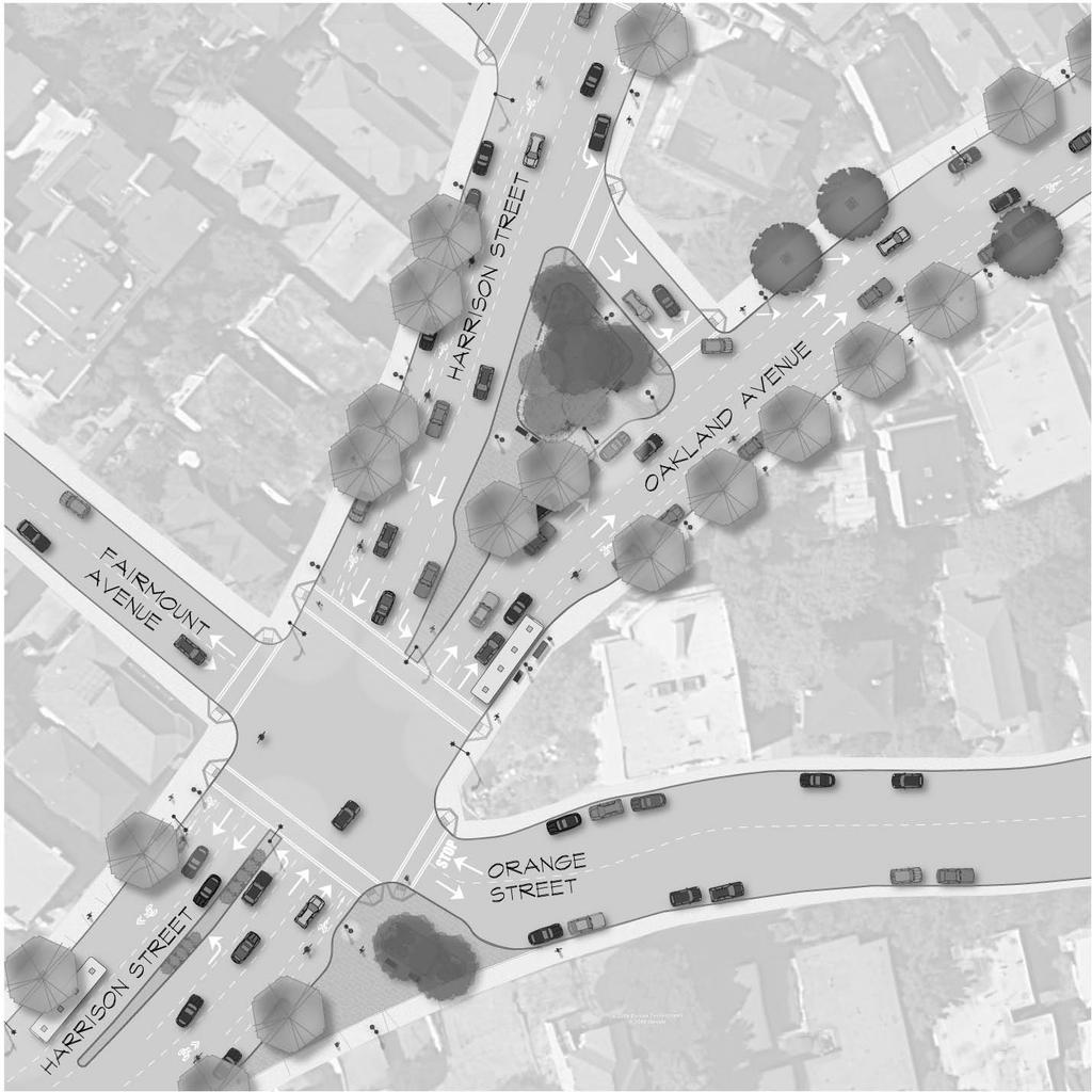
128
HARRISON STREET/OAKLAND AVENUE COMMUNITY TRANSPORTATION PLAN
 HARRISON STREET/OAKLAND AVENUE Community Workshop #4: Draft Plan Review December 3, 2009 D E S I G N, C O M M U N I T Y & E N V I R O N M E N T INTRODUCTIONS Key Project Staff: Alisa Shen, Project Manager,
Bicycle and Pedestrian Advisory Committee (BPAC) November 21, 2013
 November 21, 2013") Bicycle and Pedestrian Advisory Committee (BPAC) November 21, 2013 OVERALL LAND USE CONCEPT Overall Broadway Valdez District: 95.5 acres (35.1 acres right-of ways + 60.4 acres developable land) Plan Subareas:
Bicycle and Pedestrian Advisory Committee (BPAC) November 21, 2013 OVERALL LAND USE CONCEPT Overall Broadway Valdez District: 95.5 acres (35.1 acres right-of ways + 60.4 acres developable land) Plan Subareas:
4. ENVIRONMENTAL IMPACT ANALYSIS 9. TRANSPORTATION AND TRAFFIC
 4. ENVIRONMENTAL IMPACT ANALYSIS 9. TRANSPORTATION AND TRAFFIC 4.9.1 INTRODUCTION The following section addresses the Proposed Project s impact on transportation and traffic based on the Traffic Study
PEDESTRIAN ACTION PLAN
 ATTACHMENT 2 CITY OF SANTA MONICA PEDESTRIAN ACTION PLAN CITY OF SANTA MONICA PEDESTRIAN ACTION PLAN This page intentionally left blank EXECUTIVE SUMMARY CHAPTER 1 EXECUTIVE SUMMARY Setting the Stage
Executive Summary Route 30 Corridor Master Plan
 Route Corridor Master Plan Project Overview The Route Corridor Master Plan is a coordinated multimodal transportation and land use plan for the entire stretch of Route through East Whiteland Township,
Living Streets Policy
 Living Streets Policy Introduction Living streets balance the needs of motorists, bicyclists, pedestrians and transit riders in ways that promote safety and convenience, enhance community identity, create
Caltrans Sloat Boulevard Pedestrian Safety Project Response to Community Questions, Comments & Concerns
 Caltrans Sloat Boulevard Pedestrian Safety Project Response to Community Questions, Comments & Concerns Revised: May 10, 2016 The California Department of Transportation (Caltrans) is planning various
CITY OF COCOA BEACH 2025 COMPREHENSIVE PLAN. Section VIII Mobility Element Goals, Objectives, and Policies
 CITY OF COCOA BEACH 2025 COMPREHENSIVE PLAN Section VIII Mobility Element Goals, Objectives, and Policies Adopted August 6, 2015 by Ordinance No. 1591 VIII MOBILITY ELEMENT Table of Contents Page Number
Chapter 3: Multi-Modal Circulation and Streetscapes
 CHAPTER 3: MULTI-MODAL CIRCULATION AND STREETSCAPES Chapter 3: Multi-Modal Circulation and Streetscapes Overview Streetscape improvements have already been completed for Depot Street between Main Avenue
5 CIRCULATION AND STREET DESIGN
 5 CIRCULATION AND STREET DESIGN This chapter describes circulation and streetscape improvements proposed for the Northwest Chico Specific Plan Area. It includes detailed design specifications for existing
TRAFFIC ACTION PLAN. North Central Neighborhood CITY OF SAN MATEO
 TRAFFIC ACTION PLAN North Central Neighborhood CITY OF SAN MATEO Draft February 2017 Table of Contents Introduction... 1 The Traffic Forum Process... 4 Neighborhood Traffic Issues... 6 Neighborhood Recommendations
SAN FRANCISCO MUNICIPAL TRANSPORTATION AGENCY
 THIS PRINT COVERS CALENDAR ITEM NO. : 11 DIVISION: Sustainable Streets BRIEF DESCRIPTION: SAN FRANCISCO MUNICIPAL TRANSPORTATION AGENCY Approving traffic modifications on Twin Peaks Boulevard between Christmas
STONY PLAIN ROAD STREETSCAPE
 Jasper Place Revitalization Strategy: Vision The people involved in the Jasper Place Revitalization Strategy envision: Goal 1: Feeling safe in our community Create a community where feeling safe is common--where
2014/2015 BIKE ROUTE PLAN 83 AVENUE PROTECTED BIKE LANE
 About the Project 2014/2015 BIKE ROUTE PLAN The City of Edmonton is planning a major bike route on the south side of Edmonton. This bike route is one part of a plan to provide citizens with transportation
CONNECTING PEOPLE TO PLACES
 CONNECTING PEOPLE TO PLACES 82 EAST BENCH MASTER PLAN 07 Introduction The East Bench transportation system is a collection of slow moving, treelined residential streets and major arteries that are the
Proposed. City of Grand Junction Complete Streets Policy. Exhibit 10
 Proposed City of Grand Junction Complete Streets Policy Exhibit 10 1 City of Grand Junction Complete Streets Policy Vision: The Complete Streets Vision is to develop a safe, efficient, and reliable travel
Solana Beach Comprehensive Active Transportation Strategy (CATS)
") Solana Beach Comprehensive Active Transportation Strategy (CATS) 3.0 Goals & Policies The Solana Beach CATS goals and objectives outlined below were largely drawn from the Solana Beach Circulation Element
Solana Beach Comprehensive Active Transportation Strategy (CATS) 3.0 Goals & Policies The Solana Beach CATS goals and objectives outlined below were largely drawn from the Solana Beach Circulation Element
City of Novi Non-Motorized Master Plan 2011 Executive Summary
 City of Novi Non-Motorized Master Plan 2011 Executive Summary Prepared by: February 28, 2011 Why Plan? Encouraging healthy, active lifestyles through pathway and sidewalk connectivity has been a focus
RESOLUTION NO ?? A RESOLUTION OF THE CITY OF NEPTUNE BEACH ADOPTING A COMPLETE STREETS POLICY
 RESOLUTION NO. 2018-?? A RESOLUTION OF THE CITY OF NEPTUNE BEACH ADOPTING A COMPLETE STREETS POLICY WHEREAS, safe, convenient, and accessible transportation for all users is a priority of the City of Neptune
Tonight is for you. Learn everything you can. Share all your ideas.
 Strathcona Neighbourhood Renewal Draft Concept Design Tonight is for you. Learn everything you can. Share all your ideas. What is Neighbourhood Renewal? Creating a design with you for your neighbourhood.
CITY OF OAKLAND. 27th Street Bikeway Feasibility and Design. Final Report (v3) March 23, Kimley-Horn and Associates, Inc.
 March 23, Kimley-Horn and Associates, Inc.") CITY OF OAKLAND 27th Street Bikeway Feasibility and Design Final Report (v3) March 23, 2007 PREPARED BY: Kimley-Horn and Associates, Inc. Table of Contents 1. Introduction 3 2. 27 th Street/Bay Place Corridor
CITY OF OAKLAND 27th Street Bikeway Feasibility and Design Final Report (v3) March 23, 2007 PREPARED BY: Kimley-Horn and Associates, Inc. Table of Contents 1. Introduction 3 2. 27 th Street/Bay Place Corridor
Vision: Traditional hamlet with an attractive business/pedestrian friendly main street connected to adjacent walkable neighborhoods
 N D. Focus Area II Vision: Traditional hamlet with an attractive business/pedestrian friendly main street connected to adjacent walkable neighborhoods Transit Road Focus Area II is located in the Hamlet
Broad Street Bicycle Boulevard City Council Study Session Summary
 Broad Street Bicycle Boulevard City Council Study Session Summary Overview: On August 15 th, 2017, a City Council Study Session was held to invite community input and request City Council guidance on a
Agenda. Overview PRINCE GEORGE S PLAZA METRO AREA PEDESTRIAN PLAN
 PRINCE GEORGE S PLAZA METRO AREA PEDESTRIAN PLAN May 28, 2008 Agenda Welcome and introductions Project overview and issue identification Planning context and strengths Design challenges and initial recommendations
Bicycle Master Plan Goals, Strategies, and Policies
 Bicycle Master Plan Goals, Strategies, and Policies Mobilizing 5 This chapter outlines the overarching goals, action statements, and action items Long Beach will take in order to achieve its vision of
ALLEY 24 TRAFFIC STUDY
 ALLEY 24 TRAFFIC STUDY in City of Frostburg, Maryland January 2013 3566 Teays Valley Road Hurricane, WV Office: (304) 397-5508 www.denniscorporation.com Alley 24 Traffic Study January 2013 Frostburg, Maryland
ACTIVE TRANSPORTATION
 ACTIVE TRANSPORTATION Mobility 2040 Supported Goals Improve the availability of transportation options for people and goods. Support travel efficiency measures and system enhancements targeted at congestion
Exhibit 1 PLANNING COMMISSION AGENDA ITEM
 Exhibit 1 PLANNING COMMISSION AGENDA ITEM Project Name: Grand Junction Circulation Plan Grand Junction Complete Streets Policy Applicant: City of Grand Junction Representative: David Thornton Address:
CITY OF BLOOMINGTON COMPLETE STREETS POLICY
 CITY OF BLOOMINGTON COMPLETE STREETS POLICY POLICY OBJECTIVE: The City of Bloomington will enhance safety, mobility, accessibility and convenience for transportation network users of all ages and abilities,
Complete Street Analysis of a Road Diet: Orange Grove Boulevard, Pasadena, CA
 Complete Street Analysis of a Road Diet: Orange Grove Boulevard, Pasadena, CA Aaron Elias, Bill Cisco Abstract As part of evaluating the feasibility of a road diet on Orange Grove Boulevard in Pasadena,
Welcome! San Jose Avenue Open House August 25, 2015
 Welcome! San Jose Avenue Open House August 25, 2015 Vision Zero The City and County of San Francisco adopted Vision Zero San Francisco Vision Zero High Injury Network as a policy in 2014, committing an
SANTA CLARA COUNTYWIDE BICYCLE PLAN August 2008
 SANTA CLARA COUNTYWIDE BICYCLE PLAN August 2008 To assist VTA and Member Agencies in the planning, development and programming of bicycle improvements in Santa Clara County. Vision Statement To establish,
Santa Clara I-280 CORRIDOR STUDY
 Santa Clara I-280 CORRIDOR STUDY OCTOBER 2017 PREPARED BY: 1.1 Background The I-280 Corridor Study within Santa Clara County is a high-level highway planning study led by the Santa Clara VTA, in partnership
2014/2015 BIKE ROUTE PLAN 83 AVENUE PROTECTED BIKE LANE
 About the Project The City of Edmonton is planning a major bike route on the southside of Edmonton. The Strathcona Bike Route will connect the communities of Strathcona, Garneau and the University area,
NEWMARKET UPHAM S CORNER
 SOUTH STATION Planning Initiative NEWMARKET UPHAM S CORNER COLUMBIA ROAD (P) FOUR CORNERS/GENEVA Working Advisory Group (WAG) Meeting #5 TALBOT AVENUE MORTON STREET BLUE HILL AVE/CUMMINS HWY (P) RIVER
MEMORANDUM. Charlotte Fleetwood, Transportation Planner
 MEMORANDUM Date: Updated August 22, 2017 To: Organization: Charlotte Fleetwood, Transportation Planner Boston Transportation Department From: Jason DeGray, P.E., PTOE, Regional Director of Engineering
East 12 th Street Bikeway Feasibility Study
 Final Report East 12 th Street Bikeway Feasibility Study Prepared for: City of Oakland Public Works Agency Submitted by: 180 Grand Avenue, Suite 250 Oakland, CA 94612 Phone: (510) 839-1742; Fax: (510)
Ann Arbor Downtown Street Plan
 1 Ann Arbor Downtown Street Plan Public Workshop #1 We know that. 2 Public right-of-way (streets, sidewalks, and alleys) make up 30% of the total District area of downtown. Streets need to provide mobility
Broad Street Bicycle Boulevard Design Guidelines
 Broad Street Bicycle Boulevard Design Guidelines Building from the strategies introduced in the 2013 Bicycle Transportation Plan and community input received thus far, City Transportation Staff have identified
Shockoe Bottom Preliminary Traffic and Parking Analysis
 Shockoe Bottom Preliminary Traffic and Parking Analysis Richmond, Virginia August 14, 2013 Prepared For City of Richmond Department of Public Works Prepared By 1001 Boulders Pkwy Suite 300, Richmond, VA
Berkeley Strategic Transportation Plan A-76
 Berkeley Strategic Transportation Plan A-76 Appendices 1. A Team Effort 2. Where We ve Been A-11 Berkeley Strategic Transportation Plan Alameda County Transportation Plan Alameda County will be served
Chapter 5 Future Transportation
 Chapter 5 Future Transportation The Future Land Use Plan identifies the desired land use designations. The land uses desired for Crozet depend, in large part, on the success of the transportation system,
C C C
 C-012-001 Thank you for your support for the creation of new public space and nonmotorized access between downtown and the waterfront through the Overlook Walk, the East-West Connections, and the Promenade.
APPENDIX A: Complete Streets Checklist DRAFT NOVEMBER 2016
 APPENDIX A: Complete Streets Checklist DRAFT NOVEMBER 2016 Complete Streets Checklist MetroPlan Orlando s Complete Streets Checklist is an internal planning tool for staff to further implementation of
NEIGHBORHOOD TRAFFIC CALMING POLICY
 NEIGHBORHOOD TRAFFIC CALMING POLICY I. PURPOSE The City of Kent continually strives to strengthen and protect its neighborhoods by improving the quality of life in residential areas. Traffic conditions
TRAFFIC IMPACT ANALYSIS
 TRAFFIC IMPACT ANALYSIS FOR THE CHAMPAIGN UNIT#4 SCHOOL DISTRICT PROPOSED HIGH SCHOOL (SPALDING PARK SITE) IN THE CITY OF CHAMPAIGN Final Report Champaign Urbana Urbanized Area Transportation Study 6/24/2014
NM-POLICY 1: Improve service levels, participation, and options for non-motorized transportation modes throughout the County.
 Transportation PRINCE WILLIAM COUNTY 2008 COMPREHENSIVE PLAN NON-MOTORIZED PLAN CONTENTS Goals, Policies, and Action Strategies Table 4 (Bike Facility Classifications and Descriptions) Table 5 (Bike Facility
PROPOSED BICYCLE AND PEDESTRIAN FACILITY Vicinity of Route 123/I-495 Interchange Tysons, Fairfax County, Virginia
 PROPOSED BICYCLE AND PEDESTRIAN FACILITY Vicinity of Route 123/I-495 Interchange Tysons, Fairfax County, Virginia PRELIMINARY ENGINEERING REPORT Prepared for: Prepared by: July 2017 Table of Contents 1
Appendix A: Crosswalk Policy
 Appendix A: Crosswalk Policy Appendix A: Crosswalk Policy Introduction This citywide Crosswalk Policy is aimed at improving pedestrian safety and enhancing pedestrian mobility by providing a framework
TRAFFIC ACTION PLAN. Laurie Meadows Neighborhood CITY OF SAN MATEO
 TRAFFIC ACTION PLAN Laurie Meadows Neighborhood CITY OF SAN MATEO Draft January 2017 Table of Contents Introduction... 2 The Traffic Forum Process... 5 Neighborhood Traffic Issues... 7 Neighborhood Recommendations
Corpus Christi Metropolitan Transportation Plan Fiscal Year Introduction:
 Introduction: The Safe, Accountable, Flexible, Efficient Transportation Equity Act: A Legacy for Users (SAFETEA-LU) has continued the efforts started through the Intermodal Surface Transportation Efficiency
Item No. 14 Town of Atherton
 Item No. 14 Town of Atherton CITY COUNCIL STAFF REPORT CONSENT AGENDA TO: THROUGH: FROM: HONORABLE MAYOR AND CITY COUNCIL GEORGE RODERICKS, CITY MANAGER MICHAEL KASHIWAGI, COMMUNITY SERVICES DIRECTOR MARTY
o n - m o t o r i z e d transportation is an overlooked element that can greatly enhance the overall quality of life for the community s residents.
 N o n - m o t o r i z e d transportation is an overlooked element that can greatly enhance the overall quality of life for the community s residents. 84 Transportation CHAPTER 11 INTRODUCTION Transportation
TRANSPORTATION TRAINING TOPICS. April 6, 2010
 TRANSPORTATION TRAINING TOPICS April 6, 2010 Roles of Transportation Providers Context and Policy Makers Division of Transportation and Traffic Other City Operations Other Transportation Operators CMA
San Jose Transportation Policy
 San Jose Transportation Policy Protected Intersections in LOS Policies to Support Smart Growth Presented by: Manuel Pineda City of San Jose Department of Transportation Bay Area Map San Francisco Oakland
INTRODUCTION. The focus of this study is to reduce congestion and improve mobility for all modes of transportation. Figure ES-1 Study Corridor Map
 INTRODUCTION The I-280 Corridor Study is a highway planning study led by Santa Clara VTA, in partnership with the City of Cupertino and in coordination with other stakeholders in the study area. The study
Paoli Road Improvement Feasibility Study
 Paoli Road Improvement Feasibility Study & Public Participation Project March 24, 2015 Prepared for: Tredyffrin Township Prepared by: McMahon Associates, Inc. with Town Planning Partnership, LLC Glackin
Circulation in Elk Grove includes: Motor vehicles, including cars and trucks
 Circulation, as it is used in this General Plan, refers to the many ways people and goods move from place to place in Elk Grove and the region. Circulation in Elk Grove includes: Motor vehicles, including
3.16 TRANSPORTATION, CIRCULATION, AND PARKING Regulatory Setting Environmental Setting ROADWAY SYSTEM
 3.16 TRANSPORTATION, CIRCULATION, AND PARKING This section assesses the potential for implementation of the Orchard Park Redevelopment component of the 2018 LRDP to result in impacts related to transportation,
General Plan Circulation Element Update Scoping Meeting April 16, 2014 Santa Ana Senior Center, 424 W. 3rd Street, Santa Ana, CA 92701
 General Plan Circulation Element Update Scoping Meeting April 16, 2014 Santa Ana Senior Center, 424 W. 3rd Street, Santa Ana, CA 92701 Meeting Agenda 1. Purpose of Scoping Meeting 2. Project Overview 3.
TRAFFIC STUDY GUIDELINES Clarksville Street Department
 TRAFFIC STUDY GUIDELINES Clarksville Street Department 9/1/2009 Introduction Traffic studies are used to help the city determine potential impacts to the operation of the surrounding roadway network. Two
David DiPierro, John Amberson. Steering Committee Meeting #4 Overview
 IBI GROUP 18401 Von Karman Avenue Suite 110 Irvine CA 92612 USA tel 949 833 5588 fax 949 833 5511 ibigroup.com Memorandum To/Attention Steering Committee Members Date February 17, 2016 From IBI Group Project
CITY OF OTTAWA ROADWAY MODIFICATION APPROVAL UNDER DELEGATED AUTHORITY
 RMA-2015-ATM-038 CITY OF OTTAWA ROADWAY MODIFICATION APPROVAL UNDER DELEGATED AUTHORITY DATE: April 22, 2015 SUBJECT Approval of Roadway Modifications Recommended through an Area Traffic Management Study
Lyons Avenue/Dockweiler Road Extension Project Draft Environmental Impact Report. Appendix I Traffic Impact Study
 Lyons Avenue/Dockweiler Road Extension Project Draft Environmental Impact Report Appendix I Traffic Impact Study Street 0 80-1947 500.4501 RITA ld Court 0 91355-1096 400.7401 LA n Avenue 0 590-3745 300-9301
Classification Criteria
 SCHEDULE D TO RECOMMENDED OFFICIAL PLAN AMENDMENT NO. 40 SCHEDULE C-4 Road Criteria Criteria Traffic Service Objective Land Service/Access Typical Daily Traffic Volume Flow characteristics Travel Speed
5.0 Roadway System Plan
 Southwest Boise Transportation Study Page 16 5.0 Roadway System Plan The Roadway System Plan outlines roadway improvements in the Initial Study Area. It forecasts future deficiencies on the arterial system,
EXECUTIVE SUMMARY. Vision
 Vision Walking and bicycling in Salt Lake City will be safe, convenient, comfortable, and viable transportation options that connect people to places, foster recreational and economic development opportunities,
Addendum to Mitigated Negative Declaration
 Addendum Date: Case No.: 2014.1499E Project Title: (MDSP) - Mission Valencia Green Gateway Streetscape Project Original: 2008.1075, MDSP Mitigated Negative Declaration Project Sponsor: Charlie Ream, San
City of Gainesville Transportation/Roadway Needs PROJECT SUMMARY
 A1 Roadway Resurfacing $23,846,000 TYPE: Preservation of existing system Roadway resurfacing A2 Signal Replacement $6,000,000 TYPE: Preservation of existing system Replace traffic signals. B1 W 6th St
Chapter 14 PARLIER RELATIONSHIP TO CITY PLANS AND POLICIES. Recommendations to Improve Pedestrian Safety in the City of Parlier (2014)
") Chapter 14 PARLIER This chapter describes the current status and future plans for biking and walking in the City of Parlier. RELATIONSHIP TO CITY PLANS AND POLICIES The Parlier General Plan is the primary
Chapter 14 PARLIER This chapter describes the current status and future plans for biking and walking in the City of Parlier. RELATIONSHIP TO CITY PLANS AND POLICIES The Parlier General Plan is the primary
PRINCE GEORGE S PLAZA METRO AREA PEDESTRIAN PLAN
 PRINCE GEORGE S PLAZA METRO AREA PEDESTRIAN PLAN May 28, 2008 Agenda Welcome and introductions Project overview and issue identification Planning context and strengths Design challenges and initial recommendations
Plant City Walk-Bike Plan
 Plant City Walk-Bike Plan Plant City Commute Mode Share 2.2% 1.4% 2.9% Drove alone 10.2% Carpooled Public transportation (0.1%) Walked Used a Bike (0.4%) 82.9% Taxicab, motorcycle, or other means Worked
SAN FRANCISCO MUNICIPAL TRANSPORTATION AGENCY
 THIS PRINT COVERS CALENDAR ITEM NO. : 10.2 DIVISION: Sustainable Streets BRIEF DESCRIPTION: SAN FRANCISCO MUNICIPAL TRANSPORTATION AGENCY Adopting Conceptual Proposal for Streetscape Improvements to Broadway,
Pedestrian Project List and Prioritization
 To: Kyle Wagenschutz, City of Memphis CC: From: Anne Conlon and John Cock, Alta Planning + Design Date: December, 2014 Re: Project List Development (Task 3.1-3.2) and Project List Prioritization (Task
COMMUNITY MEETING AGENDA
 COMMUNITY MEETING AGENDA Welcome and Introductions SAFE Presentation Project Presentation Priorities Feedback Next Steps Q&A Santa Cruz Avenue Corridor Study 1 Santa Cruz Avenue Corridor Study Community
Telegraph Avenue Complete Streets DRAFT Recommendations. Oakland Public Works Department September 11 and 13, 2014 Open Houses
 Telegraph Avenue Complete Streets DRAFT Recommendations Oakland Public Works Department September 11 and 13, 2014 Open Houses Presentation Overview What are complete streets? What problem are we trying
Sandwich Pedestrian/Bicycle Planning
 Sandwich Pedestrian/Bicycle Planning Improved Pedestrian and Bicycle Connections with the Cape Cod Canal Multi-use Path February 2014 Table of Contents Introduction... 1 Background... 1 Study Goals...
Chapter 5. Complete Streets and Walkable Communities.
 Chapter 5. Complete Streets and Walkable Communities. 5.1 Description of Complete Streets. Cities throughout the world, and specifically the United States, are coming to embrace a new transportation and
Chapter 4 Traffic Analysis
 Chapter 4 Traffic Analysis PURPOSE The traffic analysis component of the K-68 Corridor Management Plan incorporates information on the existing transportation network, such as traffic volumes and intersection
TABLE OF CONTENTS. Executive Summary
 Executive Summary Background... ES-1 Pedestrian Network... ES-2 Bikeway Network... ES-2 Collision History... ES-2 Public Input... ES-4 Conclusions and Recommendations... ES-4 1. Introduction and Setting
Feasibility Study. Expo-Downtown Bicycle Connector
 Feasibility Study Expo-Downtown Bicycle Connector May 2017 Table of Contents Introduction... 2 Project Goals... 2 Study Scope... 2 Community Engagement... 3 Project Description... 6 Considerations... 6
Clackamas County Comprehensive Plan
 ROADWAYS The County s road system permits the movement of goods and people between communities and regions, using any of a variety of modes of travel. Roads provide access to virtually all property. They
University of Victoria Campus Cycling Plan Terms of Reference. 1.0 Project Description
 University of Victoria Campus Cycling Plan Terms of Reference 1.0 Project Description The Campus Cycling Plan, a first for the University, will provide a comprehensive and coordinated approach to support
Active Transportation Facility Glossary
 Active Transportation Facility Glossary This document defines different active transportation facilities and suggests appropriate corridor types. Click on a facility type to jump to its definition. Bike
Northbound San Jose Avenue & I-280 Off-Ramp Road Diet Pilot Project
 Project Overview Fed by a two-lane Interstate-280 (I-280) off-ramp, high vehicular volumes and speeds are longstanding issues along San Jose Avenue. Residents in the surrounding neighborhoods have expressed
Appendix A-2: Screen 1 Alternatives Report
 Appendix A-2: Screen 1 Alternatives Report SCREEN 1 ALTERNATIVES REPORT Western & Ashland Corridors Bus Rapid Transit (BRT) Project Prepared for Chicago Transit Authority 567 West Lake Street Chicago,
Ocean Park Boulevard Green Street Project Alternatives & Trade Offs
 Planning Commission March 4, 2009 Ocean Park Boulevard Green Street Project Alternatives & Trade Offs Purpose of Tonight s Meeting Review concept plans and options Provide input on alternatives and trade-offs
5. RUNNINGWAY GUIDELINES
 5. RUNNINGWAY GUIDELINES These guidelines should be considered collectively when making runningway decisions. A runningway is the linear component of the transit system that forms the right-of-way reserved
List of Attachments. Location Map... Site Plan... City of Lake Elsinore Circulation Element... City of Lake Elsinore Roadway Cross-Sections...
 List of Attachments Exhibits Location Map... Site Plan... City of Lake Elsinore Circulation Element... City of Lake Elsinore Roadway Cross-Sections... Existing Lane Geometry and Traffic Controls... Existing
Downtown Naples Mobility and Connectivity Study. Naples City Council Presentation January 2017
 Downtown Naples Mobility and Connectivity Study Naples City Council Presentation January 2017 Agenda 1. Introduction 2. Scope Review 3. Project Schedule 4. Existing Conditions 5. Public Charrette 6. Mobility
REGIONAL BICYCLE AND PEDESTRIAN DESIGN GUIDELINES
 REGIONAL BICYCLE AND PEDESTRIAN DESIGN GUIDELINES November 16, 2011 Deb Humphreys North Central Texas Council of Governments Bicycle and Pedestrian Advisory Committee Snapshot of the Guide 1. Introduction
City of Wilsonville 5 th Street to Kinsman Road Extension Project
 City of Wilsonville 5 th Street to Kinsman Road Walking Tour & Neighborhood Workshop Summary Report Public Outreach Overview On July 18 th, 2017, the City of Wilsonville hosted a neighborhood walking tour
Los Altos Hills Town Council - June 18, 2015 Palo Alto City Council June 22, AGENDA ITEM #2.B Presentation
 Los Altos Hills Town Council - June 18, 2015 Palo Alto City Council June 22, 2015 AGENDA ITEM #2.B Presentation Previous Presentations Los Altos Hills Town Council in May 2014 and February 2015 Palo Alto
Magnolia Place. Traffic Impact Analysis. Prepared for: City of San Mateo. Prepared by: Hexagon Transportation Consultants, Inc.
 Magnolia Place Traffic Impact Analysis Prepared for: City of San Mateo Prepared by: Hexagon Transportation Consultants, Inc. Updated January 4, 2010 Table of Contents 1. Introduction...1 2. Existing Conditions...6
SAN FRANCISCO MUNICIPAL TRANSPORTATION AGENCY
 THIS PRINT COVERS CALENDAR ITEM NO. : 12 DIVISION: Sustainable Streets BRIEF DESCRIPTION: SAN FRANCISCO MUNICIPAL TRANSPORTATION AGENCY Approving various bicycle improvements and traffic modifications
UPTOWN REGIONAL BIKE CORRIDORS PROJECT SAN DIEGO ASSOCIATION OF GOVERNMENTS
 UPTOWN REGIONAL BIKE CORRIDORS PROJECT SAN DIEGO ASSOCIATION OF GOVERNMENTS SUMMARY REPORT: COMMUNITY UPDATE MEETING February 6, 2014 6 8:30 p.m. Roosevelt Middle School Library 3366 Park Blvd, San Diego
BD RESOLUTION NO RESOLUTION ADOPTING THE VISION ZERO RAMP INTERSECTION STUDY PHASE 1
 BD00 RESOLUTION NO. - RESOLUTION ADOPTING THE VISION ZERO RAMP INTERSECTION STUDY PHASE [NTIP PLANNING] FINAL REPORT WHEREAS, The Vision Zero Ramp Intersection Study Phase was recommended by Commissioner
City of Wayzata Comprehensive Plan 2030 Transportation Chapter: Appendix A
 A1. Functional Classification Table A-1 illustrates the Metropolitan Council s detailed criteria established for the functional classification of roadways within the Twin Cities Metropolitan Area. Table
Chapter 13 ORANGE COVE
 Chapter 13 ORANGE COVE This chapter describes the current status and future plans for biking and walking in the City of Orange Cove. RELATIONSHIP TO CITY PLANS AND POLICIES The Orange Cove General Plan
Bay to Bay Boulevard Complete Streets Project
 Bay to Bay Boulevard Complete Streets Project Dale Mabry Highway to Bayshore Boulevard February 08, 2018 Photo Source: Tampa Bay Times Alessandra Da Pra Meeting Format Introduction Resurfacing Information