TRAFFIC IMPACT ANALYSIS FOR A PROPOSED HOTEL / RESIDENTIAL DEVELOPMENT. The Beverly Hilton 9876 Wilshire Boulevard City of Beverly Hills
|
|
|
- Miles Lucas
- 5 years ago
- Views:
Transcription


1
2 TRAFFIC IMPACT ANALYSIS FOR A PROPOSED HOTEL / RESIDENTIAL DEVELOPMENT The Beverly Hilton 9876 Wilshire Boulevard City of Beverly Hills Prepared for: Oasis West Realty LLC Prepared by: Overland Traffic Consultants, Inc Tourney Road # 206 Santa Clarita, California (661) February 2007
3 EXECUTIVE SUMMARY Project Description The Beverly Hilton Revitalization Plan for redevelopment of The Beverly Hilton site includes the net removal of 47 rooms from an existing 569 room hotel (522 rooms remaining) and construction of 120 residences. There will be no change in the ballroom space. Approximately 13,030 square feet of non - hotel office space will also be removed as part of the project. The project is located at 9876 Wilshire Boulevard in the City of Beverly Hills as shown in the following aerial photograph. Estimated Traffic Generation The trip generation rates and peak hour period impacts for luxury residential uses are generally lower than those for other residential and commercial uses due to the characteristics of luxury residential owners. Luxury residential owners, for example, tend to travel extensively, may have second homes, are often retired, and, if not retired, tend to travel to work at different times than the traditional 9-5 work schedule or tend to work at home. This results in fewer trips, and fewer peak-hour trips, than other condominium and residential uses. It should also be noted that luxury condominium trip generation rates based on local survey data, overall, are relatively low, and are approximately 50% of the trip generation rates applicable to hotel uses. Estimates of the traffic generated by the proposed project were calculated using the industry standard traffic generation rates developed by the Institute of Transportation Engineers (ITE). After accounting for the removal of the existing hotel rooms and the existing non-hotel office uses, the net change in site generated traffic added by the project to the surrounding streets is estimated at 7 morning peak hour trips and 16 afternoon peak hour trips. Based on the analysis in this study, it has been determined that the change in traffic flow generated by the proposed project will not significantly impact the traffic flow at any of the study intersections during a.m. or p.m. peak time periods. In addition to the ITE evaluation of the potential traffic generation, peak hour surveys for hotels located in Beverly Hills and luxury condominium uses in Century City and on 9876 Wilshire Boulevard Page i February 2007 Executive Summary
4 Wilshire Boulevard near Westwood were conducted to determine local trip making characteristics for each land use. The survey results show that actual traffic generated by luxury condominiums is lower than the traffic estimated using the ITE traffic generation rates. Using the local survey data, the net change in peak hour traffic associated with the project is 14 fewer morning peak hour trips and 10 less afternoon peak hour trips. Notwithstanding the local data, to obtain a conservative result, the ITE trip rates were used to analyze the higher estimate of project traffic. The results of these calculations are included in the two tables below: Estimated Project Traffic Generation (ITE Traffic Generation Rates) AM Peak Hour PM Peak Hour Land Use Size Daily Total In Out Total In Out Proposed Land Use Condominium 120 units Hotel 522 rooms 4, Subtotal 4, Existing Land Use Hotel 569 rooms (4,649) (318) (193) (125) (335) (176) (159) Non-Hotel Office 13,030 sf (143) (20) (18) (2) (19) (3) (16) Subtotal (4,792) (338) (211) (127) (354) (179) (175) Total (25) (9) Estimated Project Traffic Generation (Empirical Traffic Generation Rates) AM Peak Hour PM Peak Hour Land Use Size Daily Total In Out Total In Out Proposed Land Use Condominium 120 units na Hotel 522 rooms na Subtotal na Existing Land Use Hotel 569 rooms na (364) (239) (125) (467) (256) (211) Non-Hotel Office 13,030 sf na (20) (18) (2) (19) (3) (16) Subtotal na (384) (257) (127) (486) (259) (227) na not available Total na (14) (25) 11 (10) 1 (11) 9876 Wilshire Boulevard Page ii February 2007 Executive Summary

799-8423 v, (661)799-8456 f, OTCINC@attbi.")
5 PROJECT SITE 3/17/06 PROJECT SETTING Overland Traffic Consultants, Inc Tourney Road #206, Santa Clarita, CA (661) v, (661) f, beverlyhillshotel_setting
6 Project Access Access for the 402 hotel room component of the project, located in the existing Wilshire Tower and along the northern edge of the property, will remain via a reconstructed entrance/exit driveway on Merv Griffin Way. Two residential structures located along Merv Griffin Way will contain 90 residences total (42 units in residence A and 48 units in the residence B), and each will have its own circular driveway, as well as direct access to an underground parking facility. A relocated right-turn entrance/exit driveway is also planned on Santa Monica Boulevard north of Merv Griffin Way. To enforce right turns in and out of this driveway, a landscaped median is proposed within the existing painted median on Santa Monica Boulevard. The proposed Waldorf=Astoria building of 30 residences and 120 hotel rooms located at the corner of Wilshire Boulevard and Santa Monica Boulevard will have vehicular access via a relocated driveway on Santa Monica Boulevard and one new driveway on Wilshire Boulevard; both of these driveways will be restricted to right-turns only. Access to underground parking will also be available from these driveways. Site access is illustrated below: 9876 Wilshire Boulevard Page iv February 2007 Executive Summary
7 Project s Potential Traffic Impacts The focus of this traffic study is to evaluate the potential traffic impact created by the development of the project in future years 2012 and Based on the analysis in this study, it has been determined that the change in traffic flow generated by the proposed project will not significantly impact the traffic flow at any of the study intersections during a.m. or p.m. peak time periods. Therefore, traffic mitigation measures have not been recommended for the development of this project. However, several project features have been included to address the existing traffic congestion and future cumulative traffic impacts along this major transportation corridor. These voluntary project features include roadway improvements adjacent to the project site as described in more detail below. Wilshire Boulevard Improvements The street improvements for Wilshire Boulevard consist of street widening from 2 10 feet to provide 2 left-turn lanes, 3 through lanes and a right-turn only lane at its intersection with Santa Monica Boulevard. The addition of 2 new lanes will create an additional capacity of 3,200 vehicles per hour for the Wilshire Boulevard and Santa Monica Boulevard intersection. In addition to the roadway improvements, a new improved parkway varying from 8 13 feet in width will provide for a new sidewalk, transit facilities and enhanced landscaping along the Wilshire Boulevard frontage as part of the project. Details of the roadway improvements include the following: 1. Wilshire Boulevard will be widened by 2 feet along the south side adjacent to the hotel site from Merv Griffin Way easterly to The Beverly Hilton drop off/pick up area; 2. As part of the roadway widening, the existing hotel drop off/pick up area on Wilshire Boulevard will be enlarged for loading/unloading and emergency hotel access; 3. From the hotel drop-off area to approximately 160 feet west of the Santa Monica Boulevard intersection, an additional 7 feet of street widening along the south side of Wilshire Boulevard will be included to provide a new eastbound lane on Wilshire Boulevard; 4. The curb radius at the corner of Wilshire Boulevard and Santa Monica Boulevard will be redesigned and improved to provide easier and safer right turns from Wilshire Boulevard to Santa Monica Boulevard; 9876 Wilshire Boulevard Page v February 2007 Executive Summary
8 5. From approximately 160 feet west of Santa Monica Boulevard to the intersection with Santa Monica Boulevard, an additional 3 feet of street widening and removal of the raised median island on Wilshire Boulevard will be implemented to provide a new right-turn lane only lane on Wilshire Boulevard; 6. As part of the street widening and streetscape improvements, the existing traffic signal at the intersection will be reconstructed and retimed to improve the efficiency of the Wilshire Boulevard and Santa Monica Boulevard intersection operation; and 7. Approximately 8 13 feet of new sidewalk and streetscape improvements will be provided along the Wilshire Boulevard perimeter of The Beverly Hilton. Santa Monica Boulevard Improvements Santa Monica Boulevard will be enhanced through a landscaped median located northeast of Merv Griffin Way. A new traffic signal at the intersection of Merv Griffin Way and Santa Monica Boulevard will be included to provide safe and efficient access to the site and Wilshire Boulevard. A curb line setback along Santa Monica Boulevard will be created to accommodate a new southbound lane which will accommodate approximately 1,600 additional vehicles per hour. A new on-site staging area along the Santa Monica Boulevard edge of the property will utilize existing driveways while allowing for additional production and delivery vehicle circulation and parking to satisfy event requirements and operation needs for the hotels and residences. Furthermore, the site access plan will remove one existing driveway currently located on Santa Monica Boulevard. Merv Griffin Way/Whittier Drive Improvements Merv Griffin Way will be aligned with Whittier Drive at its intersection with Wilshire Boulevard to provide a more efficient and safer intersection. The reconstructed intersection will include three lanes northbound, including a right-turn lane which will provide capacity for an additional 1,600 vehicles per hour, with two lanes southbound to Santa Monica Boulevard to increase the capacity of the intersection. In addition, a curb line setback along Merv Griffin Way north of the Hotel Entrance will allow for additional production and delivery vehicle circulation and parking to satisfy event requirements and other operation needs for the hotels and residences. With the implementation of these proposed improvements, the project will improve overall operations at the three key intersections around the site, Wilshire Boulevard and Merv Griffin Way/Whittier Drive, Wilshire Boulevard and Santa Monica Boulevard, and Santa Monica 9876 Wilshire Boulevard Page vi February 2007 Executive Summary
9 Boulevard and Merv Griffin Way. Specifically, project features at the intersection of Whittier Drive/Merv Griffin Way and Wilshire Boulevard and the intersection of Santa Monica Boulevard and Wilshire Boulevard will actually improve traffic flow, resulting in a negative net impact to existing traffic. As a result, these intersections will actually operate better, with less traffic impact, than they operate under current conditions. Parking Supply and Estimated Parking Demand Currently, The Beverly Hilton provides approximately 818 marked parking spaces in three separate parking areas: 514 spaces in the 5-level self-park parking structure, 249 spaces in the subterranean garage below the Oasis/Palm Court and 55 spaces adjacent to Trader Vic s restaurant. It should be noted that utilization of valet parking can increase the amount of onsite parking in marked and unmarked parking spaces. The proposed project will provide the 1,422 parking spaces as illustrated in Appendix D, thereby adding 604 parking spaces to the site and providing 316 parking spaces in addition to code parking requirements for the proposed project. Parking requirements for The Beverly Hilton project have been calculated as shown in the following table. The Beverly Hilton Parking Requirements Use Total Parking Ratio New Parking Spaces Required Total Number of Spaces Required Notes 578 Hotel Rooms (Original) 578 rooms N/A Existing spaces - 9 Hotel Rooms (Current) 569 rooms 1/room renovation Hotel Rooms 352 rooms 1/room Demolition of Palm Court and Lanai Rooms 170 Hotel Rooms (New) 522 rooms 1/room Waldorf=Astoria and Wilshire Additions 21-2 BR Residences (New) 522 rooms 21-2 BR units 93-3 BR Residences (New) 522 rooms 21-2 BR units 93-3 BR units 6-4 BR Residences (New) 522 rooms 21-2 BR units 93-3 BR units 6-4 BR units 2.75/2 BR unit Waldorf=Astoria Residences 3.25/3 BR unit 303 1,123 Waldorf=Astoria Residences, Residences A, and Residences B 3.25/4 BR unit 20 1,143 Residences A Non-Hotel Office 13,030 SF 1/350 SF ,106 Demolition of non-hotel office uses TOTAL REQUIRED 1,106 TOTAL PROVIDED 1, surplus spaces * Residential parking includes.25 guest parking space per unit Wilshire Boulevard Page vii February 2007 Executive Summary
10 In addition to the calculated parking requirements, a parking demand estimate has been developed using data from the Urban Land Institute and parking demand surveys conducted at The Beverly Hilton. The objective of the parking demand analysis was to determine whether there would be adequate parking to accommodate the total parking needs of The Beverly Hilton project. A key factor in the development of the hotel parking demand estimates relates closely to the meeting and banquet activities. Using the Urban Land Institute (ULI) time-of-day variations for hotel parking demand and parking demand surveys conducted during large events at The Beverly Hilton, a parking demand profile of the future hotel use was developed. Adding the residential parking requirement to the hotel parking demand provides an estimate of The Beverly Hilton total parking demand for the residences and hotel uses. As shown in the following graph, the total peak parking demand of the project has been calculated at 1,196 parking spaces, 226 spaces less than the 1,422 spaces provided Wilshire Boulevard Page viii February 2007 Executive Summary
11 WEEKEND SITE PARKING DEMAND FOR THE BEVERLY HILTON 1,500 1,400 1,300 1,200 OVERALL CAPACITY -- 1,422 SPACES 1,100 1, :00 AM 7:00 8:00 9:00 10:00 11:00 12:00 Noon 1:00 PM 2:00 3:00 4:00 5:00 6:00 TIME OF DAY PEAK DEMAND AT 9 PM 7:00 8:00 9:00 10:00 11:00 12:00 Mid TOTAL CAPACITY (1,422 SPACES) HOTEL PARKING DEMAND RESIDENTIAL PARKING REQUIRED HOTEL PARKING DEMAND & REQUIRED RESIDENTIAL PARKING (1,196 SPACES) 9876 Wilshire Boulevard Page ix February 2007 Executive Summary
12 Project Alternatives Several alternative buildout scenarios for the existing site have also been analyzed for potential traffic generating characteristics. These alternatives have been developed based on a 2.5:1 floor area ratio for the surplus FAR available for development on the site. The surplus FAR available for development on the site would allow for the development of an additional 400,822 square feet of floor area. The two commercial alternatives listed below would maximize the 2.5:1 FAR, and have been analyzed for a traffic volume comparison to the proposed project: 1. The Beverly Hilton with an office component of 400,822 sf. 2. The Beverly Hilton with retail shopping center component of 400,822 sf. The traffic generation estimates of the commercial project alternatives as compared to the proposed project are provided below. A luxury residential use at the site will result in far fewer trips than an office or retail use of the same amount of square footage. As is shown by the trip generation chart shown below, the proposed project would generate the least amount of traffic among the developable alternatives presented. Traffic Generation Comparison for Alternatives Daily AM Peak Hour PM Peak Hour Land Use Traffic Total In Out Total In Out Proposed Project Alternative 1 - Office 3, Alternative 2 - Retail 16, , Wilshire Boulevard Page x February 2007 Executive Summary
13 TABLE OF CONTENTS Chapter 1 - Introduction... 1 Chapter 2 - Project Description... 3 Chapter 3 - Environmental Setting... 6 Freeway and Street Characteristics... 6 Transit Service Chapter 4 - Project Traffic Traffic Generation Traffic Distribution Parking Supply and Estimated Parking Demand Chapter 5 - Traffic Conditions Analysis Analysis of Existing Traffic Conditions Analysis of Future (2012)Traffic Conditions Neighborhood Residential Street Impact Analysis Analysis of Future (2020)Traffic Conditions Congestion Management Program Review Chapter 6 Project Traffic Improvements Appendix A Community Plan Land Use Information Appendix B Intersection Photos and Street Classification Appendix C Transit Routes Appendix D Parking Layout Appendix E Level of Service Worksheets 9876 Wilshire Boulevard Page xi February 2007 Table of Contents
14 LIST OF FIGURES Project Location... 4 Project Site Plan... 5 Study Intersections Characteristics... 7 Project Traffic Distribution Project Traffic Assignment Percentages Project Traffic Volume - Peak Hours Base Traffic Volume - AM Peak Hours Base Traffic Volume - PM Peak Hours Future (2012) Traffic Volume (Without Project) - AM Peak Hour Future (2012) Traffic Volume (Without Project) - PM Peak Hour Future (2012) Traffic Volume (With Project) - AM Peak Hour Future (2012) Traffic Volume (With Project) - PM Peak Hour Future (2020) Traffic Volume (Without Project) - AM Peak Hour Future (2020) Traffic Volume (Without Project) - PM Peak Hour Future (2020) Traffic Volume (With Project) - AM Peak Hour Future (2020) Traffic Volume (With Project) - PM Peak Hour Wilshire Boulevard Page xii February 2007 List of Figures
15 LIST OF TABLES Project Trip Generation Rates Project Traffic Generation Parking Requirements Level of Service Definitions Base Traffic Conditions Summary Future (2012) Traffic Conditions Without Project Significant Impact Criteria Future (2012) Traffic Conditions With Project Future (2020) Traffic Conditions Without Project Future (2020) Traffic Conditions With Project Wilshire Boulevard Page xiii February 2007 List of Tables
16 CHAPTER 1 INTRODUCTION As part of the environmental review for the project, the potential traffic impact of the development has been evaluated using the Intersection Capacity Utilization (ICU) method, as required by the City of Beverly Hills. The ICU method calculates the operating conditions of each individual study intersection using a ratio of peak hour traffic volume to the intersection s capacity. Any change to the intersection s peak hour operating condition caused by an increase/decrease in traffic volume can be quantified, using this analysis method, to show the traffic impact of a proposed project. Potential traffic impacts caused by a development project that exceed limits established by the City of Beverly Hills are deemed significant traffic impacts. All significantly impacted intersections are then evaluated for possible traffic mitigation measures. Pursuant to the City of Beverly Hills traffic impact guidelines, the following steps have been taken to develop the future traffic volume estimate: (a) The existing traffic volumes were derived from other recent studies in the area; (b) Base year 2006 traffic volume was increased by a ambient growth factor of 6% to future study year 2012; (c) Traffic in (b) was added to traffic generated by other projects in the area. Baseline future data forecast derived from City traffic model and other recent traffic studies including the proposed 9900 Wilshire Boulevard project; (d) Traffic in (c) was added to the proposed project traffic (future with project scenario); (e) Base year 2006 traffic volume was increased by a ambient growth factor of 14% to future study year 2020; (f) Traffic in (e) was added to traffic generated by other projects in the area as in (c) above; (g) Traffic in (f) was added to the proposed project traffic (future with project (2020) scenario); (h) Traffic in (d & g) was added to recommended traffic mitigations, if necessary Wilshire Boulevard Page 1 February 2007 Introduction
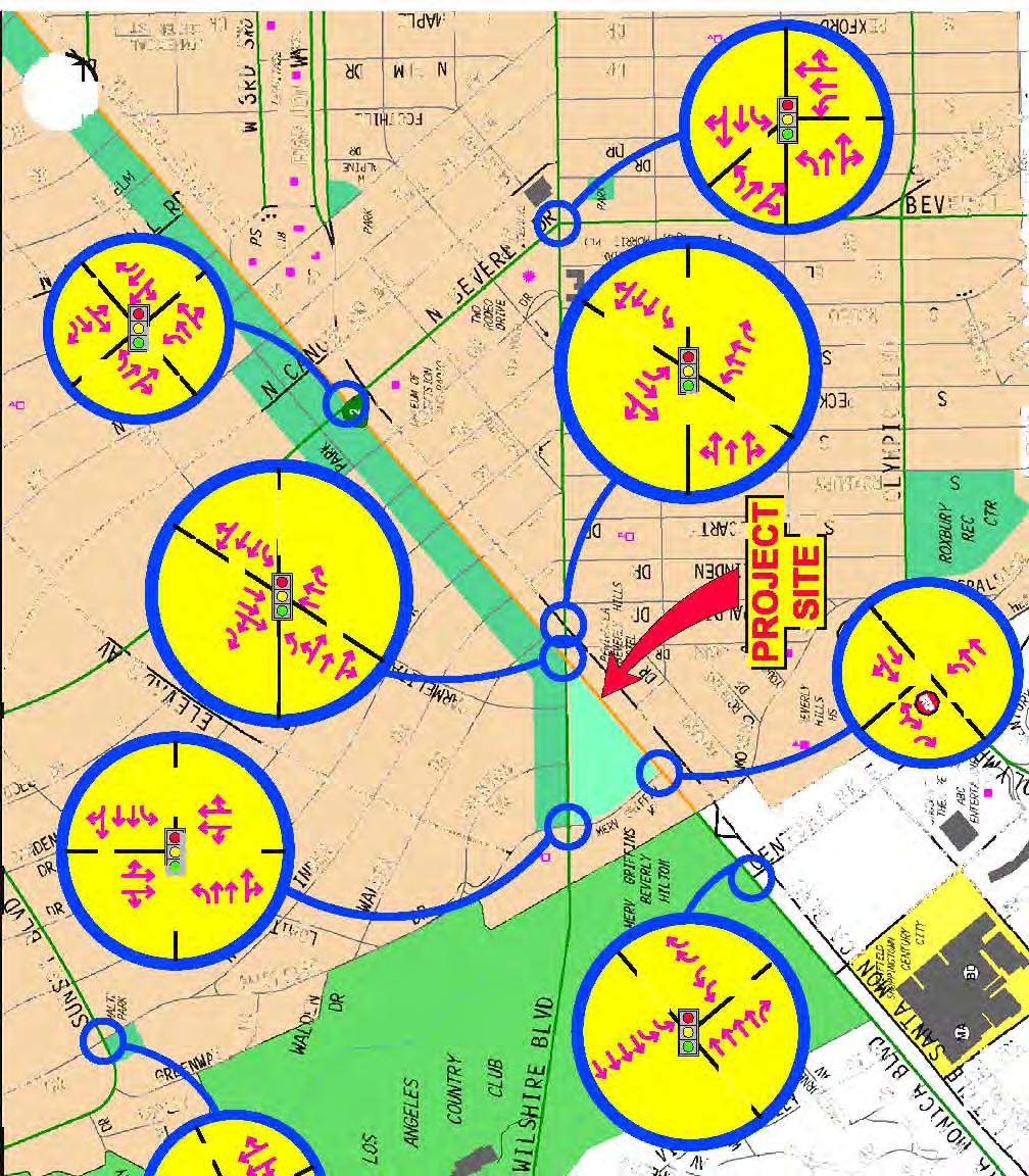
17 An ICU analysis of the existing baseline and future traffic conditions analysis has been completed at those locations expected to have the highest potential for significant traffic impacts. Morning and afternoon peak hour conditions have been evaluated at eight key intersections selected for review. Low volume intersections or intersections with minimal project traffic are not included in this analysis. It should be noted that future traffic conditions include the reconstruction of Santa Monica Boulevard, which is currently under construction, and the development of the future projects included in the Beverly Hills traffic model, with the addition of estimated trips for the proposed 9900 Wilshire Boulevard project. The intersections analyzed in this study are: 1. Santa Monica Boulevard & Merv Griffin Way; 2. Sunset Boulevard & Whittier Drive; 3. Beverly Drive & Santa Monica Boulevard; 4. Wilshire Boulevard & Whittier Drive/Merv Griffin Way; 5. Wilshire Boulevard & Santa Monica Boulevard (N); 6. Wilshire Boulevard & Santa Monica Boulevard (S); 7. Wilshire Boulevard & Beverly Drive; and, 8. Santa Monica Boulevard & Century Park East Wilshire Boulevard Page 2 February 2007 Introduction
18 CHAPTER 2 PROJECT DESCRIPTION The project is located at 9876 Wilshire Boulevard, as shown on Figure 1, and includes the net removal of 47 rooms from the existing 569 hotel rooms and the construction of 120 residences. In addition to the removal of the hotel rooms, approximately up to 13,030 square feet of non-hotel office space will also be removed from the site. The residences will be located in three structures on site. Forty-two (42) residences will be located at the corner of Merv Griffin Drive and Wilshire Boulevard. Access to this residential building will be from the circular driveway located on Merv Griffin Drive north of the hotel entrance/exit. A second structure with 48 residences will be placed along the northeast corner of Merv Griffin Drive and Santa Monica Boulevard. The access for this building is planned from a driveway on Merv Griffin Drive. A secondary restricted right turn in and out driveway will also be provided on Santa Monica Boulevard to and from the common subterranean parking garage on the site. This right-turn restriction will be enforced through a landscaped raised median on Santa Monica Boulevard to be located northeast of Merv Griffin Drive. The proposed Waldorf=Astoria building will be constructed on the triangular shaped portion of the property south of Wilshire Boulevard and north of Santa Monica Boulevard. This building will include 30 residences and 120 five-star hotel rooms. Upon completion of the project, the site will have 522 total hotel rooms consisting of the Wilshire Tower with 352 rooms, a new 3-story luxury hotel building with 50 hotel rooms and 120 hotel rooms in the new Waldorf=Astoria building. Residential and guest parking is planned in a subterranean parking structure with on-site valet and self-park service. Parking and access to the new Waldorf=Astoria building will be from a new roadway created between Wilshire Boulevard and Santa Monica Boulevard. The existing hotel will retain existing parking amounts, and all new construction will exceed City code required parking. Figure 2 illustrates the concept site plan for the project Wilshire Boulevard Page 3 February 2007 Project Description


19

20
21 CHAPTER 3 ENVIRONMENTAL SETTING The project site is triangular in shape bounded on the west by Merv Griffin Way, and on north and south by Wilshire Boulevard and Santa Monica Boulevard, two major arterial streets that traverse four cities between the downtown Los Angeles area and the Pacific Ocean. The project is located in the City of Beverly Hills, near its westerly city limit with the City of Los Angeles. In the vicinity of the project, development to the north and south is primarily residential, with commercial along the arterial streets and in the triangular area bounded by Santa Monica Boulevard, Wilshire Boulevard and Beverly Boulevard. On the east side of Merv Griffin Way between Santa Monica Boulevard and Wilshire Boulevard is a property occupied by a former Robinson s May Store and associated parking. One block west of Merv Griffin Way is the Los Angeles Country Club. Immediately southwest of the project on the south side of Santa Monica Boulevard, in the City of Los Angeles, is the Century City community which includes the Westfield Century City shopping center and the 20 th Century Fox studio. The land uses in the immediate vicinity of the project site are provided in Appendix A. In addition to collecting traffic volume data from the surrounding roadways, field surveys were conducted in the study area to determine the roadway and intersection geometry and traffic signal operations. Figure 3 illustrates the study locations, type of intersection traffic control and lane configurations for the project impact analysis. A brief description of the affected roadway facilities is provided below, with photos of the study intersections provided in Appendix B. Freeway and Street Characteristics Freeways serving the project are the Santa Monica Freeway (I - 10) and the San Diego Freeway (I-405) which are both approximately 2 miles south and west, respectively. Project access to the 405 Freeway is primarily provided via Santa Monica Boulevard with partial ramps at Tennessee Avenue south of Olympic Boulevard. This north-south freeway provides access through the San Fernando Valley and West Los Angeles to Orange County with an average daily traffic volume of approximately 310,000 vehicles per day measured at Santa Monica Boulevard Wilshire Boulevard Page 6 February 2007 Environmental Setting
22
23 Project access to the Santa Monica Freeway is primarily provided at Overland Avenue and Robertson Boulevard. This east-west freeway provides access between the City of Santa Monica and downtown Los Angeles with an average traffic volume of 270,000 vehicles per day measured at Overland Avenue. Santa Monica Boulevard is designated a major class I highway and a state highway (SR 2). Santa Monica Boulevard is currently under reconstruction between the 405-Freeway and the border between the Cities of Los Angeles and Beverly Hills. The reconstruction will join the existing north and south roadways and provide 3-4 lanes in each direction, landscaped medians and frontage roads for access to local streets. Wilshire Boulevard is also a major transportation corridor in the region with average daily traffic more than 46,000 vehicles per day just east of Santa Monica Boulevard. The City of Beverly Hills has evaluated the transit service and operating conditions in the City. These studies, known as The White Papers, and part of the City of Beverly Hills General Plan update process, were drafted by Kaku Associates to evaluate traffic conditions in the City. In addition, a Technical Background Report for the General Plan Environmental Impact Report was prepared by EIP Associates, in cooperation with Kaku Associates, and was issued in March 2006, prior to release of the Draft EIR for the General Plan. The Technical Background Report details relevant facts, observations and objectives regarding transportation and traffic and includes the following excerpts: o Records indicate that at Wilshire Boulevard and Santa Monica Boulevard approximately 5,170 passengers travel in both directions during the morning peak hour and 4,900 during the evening peak hour. o The most recent results from license plate surveys indicate that about 25 to 40 percent of the traffic on Wilshire Boulevard is regional through trips with no origin or destination in the City of Beverly Hills. Therefore, approximately percent (or roughly 28,000-35,000 vehicles of the approximate total of 44,000 per day) have origins or destinations within Beverly Hills. o Conflicting objectives for transportation exists with the need to maintain access to the City, while at the same time facilitating regional through trips so as to minimize the shifting of such traffic to residential areas. To maintain a high level of access to 9876 Wilshire Boulevard Page 8 February 2007 Environmental Setting
24 the City, strategies would logically include increasing capacity on Wilshire Boulevard, increasing capacity on parallel routes, or improving the traffic flow on each of these routes with the limited roadway capacity currently available. The other strategy is the essence of the currently ongoing Intelligent Transportation System (ITS) program by the City s Transportation Department. o Increasing the highway capacity of Wilshire Boulevard is contrary to the overall longterm objective for the City, it is in many ways counterproductive since it will likely result only in moving the traffic bottlenecks to other locations in or adjacent to the City, and serve to attract more though traffic. o Increasing the people-moving capacity of Wilshire Boulevard with transit strategies achieves the City s objective without resulting in the various negative impacts. For long-term congestion relief on Wilshire Boulevard that achieves the City s objectives, active planning and engagement for future transit systems will be necessary by City leaders. o In addition to the robust growth, the Westside area, which includes Beverly Hills and already has a population density of 14,000 persons per square mile and an employment density of 9,000 jobs per square mile, has the highest concentration of the region s designated activity centers and an existing concentration of transitsupportive land uses (almost 30 percent of the total). There are no committed eastwest transportation improvements to serve this future growth other than the possibility of the Expo LRT Line, which would not materially affect traffic congestion on Wilshire Boulevard. o The Metro Rapid Line 720 and other bus services will continue as the only viable public transit service for the foreseeable future but should only be viewed as interim solutions. o The future possibility of a western Metro Red Line subway extension should be acknowledged and actively supported by the City. Los Angeles Mayor Antonio Villaraigosa has public noted the need to extend the subway to the sea. Recent estimates by the MTA suggest a cost of $4.8 billion (in 2015 dollars) to extend the subway from Western Avenue to Ocean Avenue. In addition, a panel of experts have found that the subway can be safely built through the methane gas zone and Congressman Henry Waxman now supports the project. In order to achieve the best possible outcome for Beverly Hills, the City need to play an active role in studying the route alignment and station locations and advocating for that outcome. o Upon completion of the Santa Monica Boulevard Transit Parkway (slated for February 2007), Los Angeles County Metropolitan Transportation Authority (MTA) will institute a new Metro Rapid service route (Line 704) connecting the Vermont/Santa Monica Boulevard Metro Red Line Station to Santa Monica. This will 9876 Wilshire Boulevard Page 9 February 2007 Environmental Setting
25 supplement the current Metro Rapid Line 714 serving Beverly and Santa Monica Boulevards through Beverly Hills. o As part of the expanding Metro Rapid program, MTA and Beverly Hills are jointly installing transit signal priority throughout the City to be completed by May Transit signal priority will speed bus service along Wilshire, Olympic, La Cienega and Santa Monica Boulevards. The only major Metro Rapid intersection without transit signal priority will be at Santa Monica and Wilshire Boulevard, since there will be Metro Rapid bus service on both Wilshire and Santa Monica Boulevards. o Beverly Hills is not well served from a regional transportation accessibility standpoint. This is especially true in regard to north-south access to the City. Transit Service Local public transportation in the study area is provided by the Metropolitan Transportation Authority (Metro). Regional express service is also provided by the Antelope Valley Transit Authority. Wilshire Boulevard and Santa Monica Boulevard both serve as a major transit bus corridors; routes serving Beverly Hills immediately adjacent to the project site include Metro routes 16 & 316, 20 & 21, 14, 714 and 720. Another line providing regional service is route 786 provided by the Antelope Valley Transit Authority. The transit lines are illustrated in Appendix C Wilshire Boulevard Page 10 February 2007 Environmental Setting
26 CHAPTER 4 PROJECT TRAFFIC Traffic Generation Traffic-generating characteristics of many land uses have been surveyed by the Institute of Transportation Engineers (ITE) and published in the Trip Generation handbook, 7 th Edition. This publication of traffic generation data is the industry standard for estimating traffic generation for different land uses. The hotel, residences and non-hotel office land use estimates were utilized to evaluate the current and proposed trip generation for the project. Table 1 displays the trip generation rates used. The trip generation rates and peak hour period impacts for luxury condominium uses are generally lower than those for other residential and commercial uses due to the characteristics of luxury residential owners. Luxury condominium owners, for example, tend to travel extensively, may have second homes, are often retired, and, if not retired, tend to travel to work at different times than the traditional 9-5 work schedule or tend to work at home. This results in fewer trips, and fewer peak-hour trips, than other condominium and residential uses. It should also be noted that luxury condominium trip generation rates based on local survey data, overall, are relatively low, and are approximately 50% of the trip generation rates applicable to hotel uses. In addition, peak hour surveys for Beverly Hills hotels and luxury condominiums in Century City and on Wilshire Boulevard near Westwood were conducted to determine local trip making characteristics for each use and to ensure rates used are consistent with the actual trip generation in Beverly Hills and the west side of Los Angeles. The survey results show that actual condominium trip generation by a comparative Los Angeles area condominium use, when combined with the rates of trip generation for Beverly Hills hotels, is lower than the trip generation rates contained in the ITE trip generation database. Notwithstanding the local data, and to ensure a conservative result, the ITE trip rates were used to calculate the project trips Wilshire Boulevard Page 11 February 2007 Project Traffic
27 Table 1 Project Trip Generation Rates ITE AM Peak Hour PM Peak Hour Land Use Code Daily Total In Out Total In Out Condominium (per unit) Condominium (per unit) Counts n/a Office (per 1,000 sf) Hotel (per room) Hotel (per room) Counts n/a Table 2a Estimated Project Traffic Generation (ITE Traffic Generation Rates) AM Peak Hour PM Peak Hour Land Use Size Daily Total In Out Total In Out Proposed Land Use Condominium 120 units Hotel 522 rooms 4, Subtotal 4, Existing Land Use Hotel 569 rooms (4,649) (318) (193) (125) (335) (176) (159) Non-Hotel Office 13,030 sf (143) (20) (18) (2) (19) (3) (16) Subtotal (4,792) (338) (211) (127) (354) (179) (175) Total (25) (9) Table 2b Estimated Project Traffic Generation (Empirical Traffic Generation Rates) AM Peak Hour PM Peak Hour Land Use Size Daily Total In Out Total In Out Proposed Land Use Condominium 120 units na Hotel 522 rooms na Subtotal na Existing Land Use Hotel 569 rooms na (364) (239) (125) (467) (256) (211) Non-Hotel Office 13,030 sf na (20) (18) (2) (19) (3) (16) Subtotal na (384) (257) (127) (486) (259) (227) Total na (14) (25) 11 (10) 1 (11) 9876 Wilshire Boulevard Page 12 February 2007 Project Traffic
28 Traffic Distribution A primary factor affecting trip direction is the spatial distribution of population and employment centers which would generate project trip origins and destinations for the residents as well as destination points for the hotel occupants and employees. The estimated project directional trip distribution is also based on the study area roadway network, traffic flow patterns in and out of Beverly Hills and other traffic studies for the general area. Figure 4 illustrates the estimated area wide project traffic distribution percentages. Figures 5a and 5b shows the estimated project traffic percentages at the selected study intersections for the northeastern portion of the site (Waldorf=Astoria building) and the western portion of the site (Hotel, Residences A & B and Luxury Hotel Rooms). These trip assignments are separated due to the differences in access locations. Using the traffic assignment at each intersection and the estimated peak hour traffic volume as provided in the Table 2, peak hour traffic volumes at each study location have been calculated and are shown in Figure 6a (Waldorf=Astoria building), Figure 6b (Hotel, Residences A & B and Luxury Hotel Rooms) and 6c (combined project volumes). This estimated assignment of the project traffic flow provides the information necessary to analyze the potential traffic impacts generated by the project at the study intersections. Parking Supply and Estimated Parking Demand Supply Currently, The Beverly Hilton site provides approximately 818 marked parking spaces in three separate parking areas: 514 spaces in the 5-level self-park parking structure, 249 spaces in the valet subterranean garage below the Oasis/Palm Court and 55 spaces adjacent to Trader Vic s restaurant. It should be noted that utilization of valet parking can increase the amount of on-site parking in marked and unmarked parking spaces. The proposed project will provide the 1,422 parking spaces as illustrated in Appendix D, thereby adding 604 parking spaces to the site and 316 parking spaces in 9876 Wilshire Boulevard Page 13 February 2007 Project Traffic
29 addition to the spaces required by code. Table 3 below shows the calculated parking requirements for The Beverly Hilton project. Table 3 The Beverly Hilton Parking Requirements Use Total Parking Ratio New Parking Spaces Required Total Number of Spaces Required Notes 578 Hotel Rooms (Original) 578 rooms N/A Existing spaces - 9 Hotel Rooms (Current) 569 rooms 1/room renovation Hotel Rooms 352 rooms 1/room Demolition of Palm Court and Lanai Rooms 170 Hotel Rooms (New) 522 rooms 1/room Waldorf=Astoria and Wilshire Additions 21-2 BR Residences (New) 522 rooms 21-2 BR units 93-3 BR Residences (New) 522 rooms 21-2 BR units 93-3 BR units 6-4 BR Residences (New) 522 rooms 21-2 BR units 93-3 BR units 6-4 BR units 2.75/2 BR unit Waldorf=Astoria Residences 3.25/3 BR unit 303 1,123 Waldorf=Astoria Residences, Residences A, and Residences B 3.25/4 BR unit 20 1,143 Residences A Non-Hotel Office 13,030 SF 1/350 SF ,106 Demolition of non-hotel office uses TOTAL REQUIRED 1,106 TOTAL PROVIDED 1, surplus spaces * Residential parking includes 0.25 guest parking space per unit. Demand The objective of the parking demand analysis was to determine whether there would be adequate parking to accommodate the total parking needs of The Beverly Hilton project. A key factor in the development of the hotel parking demand estimates relates closely to the meeting and banquet activities. Using the Urban Land Institute (ULI) time-ofday variations for hotel parking demand and parking demand surveys conducted during large events at The Beverly Hilton, a parking demand profile of the future hotel use was developed. Adding the residential parking requirement to the hotel parking demand provides an estimate 9876 Wilshire Boulevard Page 14 February 2007 Project Traffic
30 of The Beverly Hilton parking demand as shown in the following graph. As shown below, the total peak parking demand of the project has been calculated at 1,196 parking spaces, 226 spaces less than the 1,422 spaces provided. The Beverly Hilton Parking Demand Graph SPACES 1,500 1,400 1,300 1,200 1,100 1, OVERALL CAPACITY -- 1,422 SPACES 6:00 AM 7:00 8:00 9:00 10:00 11:00 12:00 Noon 1:00 PM 2:00 3:00 4:00 5:00 6:00 TIME OF DAY PEAK DEMAND AT 9 PM 7:00 8:00 9:00 10:00 11:00 12:00 Mid TOTAL CAPACITY (1,422 SPACES) HOTEL PARKING DEMAND RESIDENTIAL PARKING REQUIRED HOTEL PARKING DEMAND & REQUIRED RESIDENTIAL PARKING (1,196 SPACES) 9876 Wilshire Boulevard Page 15 February 2007 Project Traffic

31

32

33
34
35
36
37 CHAPTER 5 TRAFFIC CONDITIONS ANALYSIS Analysis of Existing Traffic Conditions Multiple studies of existing area traffic conditions have recently been conducted in the vicinity of the proposed project, and review of these studies indicates relatively consistent data among the studies. Therefore, traffic volume data used in the following peak hour intersectional analysis were based on traffic counts collected in 2004 and 2005 as provided by the multiple studies conducted in the area 1. Base counts were increased by a 95% peak hour factor to reflect the rush hour time period of the analysis. Base 2006 peak hour traffic volumes are illustrated in Figures 7 and 8 for the AM and PM rush hour. The traffic conditions analysis was then conducted using the Intersection Capacity Utilization (ICU) method. All study intersections were evaluated using this methodology pursuant to the criteria established by the City of Beverly Hills. The baseline peak hour traffic counts were used along with intersection lane configurations and traffic controls to determine the intersection s operating condition. The peak hour traffic counts were used along with current intersection lane configurations to determine the intersection s operating condition. The available capacity for key intersection movements is directly related to traffic demand. The capacity per hour of green time for each approach is calculated based upon Highway Capacity Manual (HCM) methodology. To calculate capacity under the HCM method, the proportion of total signal time needed by key traffic movement is determined and compared to the total available time. The key movements are the opposing movements whose combined green time demands are the greatest, and the conflicting key movements are added and expressed as a decimal fraction. The resulting ICU displays the proportion of the total hour required to meet the intersection demand volumes in the key conflicting traffic movements Wilshire Boulevard, Meyer, Mohaddes Associates, December Wilshire Boulevard Page 22 February 2007 Traffic Conditions Analysis
38
39
40 Once the ICU value has been calculated, operating characteristics are assigned a level of service grade (A through F) to estimate the level of congestion and stability of the traffic flow. The term "Level of Service" (LOS) is used by traffic engineers to describe the quality of traffic flow. Definitions of the LOS grades are shown in Table 4, below. Table 4 Level of Service Definitions Level of Service Description of Operating Condition ICU Value A No loaded cycles and few are even close. No Approach phase is fully utilized with no delay. B A stable flow of traffic C Stable operation continues. Loading is intermittent. Occasionally drivers may have to wait more on red signal and backups my develop behind turning vehicles. D Approaching instability. Delays may be lengthy during short times within the peak hour. Vehicles may be required to wait through more than one cycle. E At or near capacity with possible long queues for left-turning vehicles. Full utilization of every signal cycle is seldom attained. F Gridlock conditions with stoppages of long duration. > 1.00 By applying these procedures to the intersection data, the ICU values and the corresponding LOS for existing traffic conditions were determined for each intersection. The ICU and LOS values are summarized in Table 5. Supporting capacity worksheets are contained in Appendix E of this report Wilshire Boulevard Page 25 February 2007 Traffic Conditions Analysis
41 Table 5 Level of Service for Existing Conditions AM Peak Hour PM Peak Hour No. Intersection ICU LOS ICU LOS 1. Merv Griffin Wy. & Santa Monica Bl F F 2. Whittier Dr. & Sunset Bl C E 3. Santa Monica Bl. & Beverly Dr D E 4. Whittier Dr./Merv Griffin Wy. & Wilshire Bl F F 5. Santa Monica Bl. (N.) & Wilshire Bl F F 6. Santa Monica Bl. (S.) & Wilshire Bl D C 7. Beverly Dr. & Wilshire Bl C D 8. Santa Monica Bl. & Century Pk. East F D Analysis of Future Traffic Conditions Future traffic volume projections have been developed to analyze the traffic conditions after completion of other planned land developments including the proposed project. Pursuant to the City of Beverly Hills traffic impact guidelines, the following steps have been taken to develop the future traffic volume estimate: (a) Existing traffic + ambient growth (6% total) to 2012 study year; (b) Traffic in (a) + growth from other projects incorporated into the City of Beverly Hills traffic model + traffic from other projects including the proposed 9900 Wilshire Boulevard project not previously included in the model (without project scenario); (c) Traffic in (b) + the proposed project traffic (with project scenario); (d) Existing traffic + ambient growth (14% total) to 2020 study year; (e) Traffic in (d) + growth from other projects incorporated into the City of Beverly Hills traffic model + traffic from other projects including the proposed 9900 Wilshire Boulevard project not previously included in the model (without project scenario); (f) Traffic in (e) + the proposed project traffic (with project scenario); (g) Traffic in (c & f) + the proposed traffic & mitigation, if necessary Wilshire Boulevard Page 26 February 2007 Traffic Conditions Analysis
42 The future cumulative analysis includes other development projects located within the study area that are either under construction or planned. As part of this analysis, development traffic generation and distribution was obtained from the City of Beverly Hills traffic model and the addition of the trips generated by the proposed 9900 Wilshire Boulevard project. The project growth that could produce additional traffic at the study intersections by the future study years 2012 and 2020 was incorporated into the analysis. It should be noted that this project, or any actions taken by the City regarding this project, does not have a direct bearing on any of the other proposed related projects. The potential traffic impact of the total traffic growth has been calculated by adding the baseline traffic volume, the ambient growth factor, and traffic from other development projects. Future cumulative without project (2012) peak hour traffic volume estimates are shown in Figures 9 and 10 for the morning and afternoon, respectively. The future level of service traffic conditions with the ambient traffic growth plus other development traffic are shown in Table Wilshire Boulevard Page 27 February 2007 Traffic Conditions Analysis
43
44
45 Table 6 Future (2012) Traffic Conditions Without Project Future Peak Existing Without Project No. Intersection Hour ICU LOS ICU LOS Growth 1 Merv Griffin Way & AM F F Santa Monica Boulevard PM F F Whittier Drive & AM C D Sunset Boulevard PM E F Santa Monica Boulevard & AM D F Beverly Drive PM E F Whittier Dr./Merv Griffin Wy. AM F F & Wilshire Boulevard PM F F Santa Monica Boulevard (N) AM F F & Wilshire Boulevard PM F F Santa Monica Boulevard (S) AM D F & Wilshire Boulevard PM C E Beverly Drive & AM C D Wilshire Boulevard PM D F Santa Monica Boulevard & AM F F Century Park East PM D F The traffic impact of project s traffic volume has been calculated by adding the project volume to the without project traffic estimates. Comparing the changes in the traffic conditions between the without and with project traffic volume scenarios provides the data to determine if the project traffic volume creates a significant traffic impact which would require traffic mitigation at any of the study intersections. According to the traffic impact standards adopted by the City of Beverly Hills for the environmental assessment, a traffic impact is considered significant if the related increase in the ICU value equals or exceeds the thresholds shown in the following Table 7. Table 7 Significant Traffic Impact Criteria LOS Final ICU Value Increase in ICU Value D E, F > or more 9876 Wilshire Boulevard Page 30 February 2007 Traffic Conditions Analysis
46 The estimated project impact values using these procedures are shown below in Table 8. As shown, none of the study intersections are impacted by the proposed project volume using the significant impact criteria established by the City of Beverly Hills. It should be noted that the impact analysis does not consider any changes to the intersection configuration except for the reconstruction of the Santa Monica Boulevard study intersections. Future cumulative with project peak hour traffic volumes for development are shown in Figures 11 and 12 for the morning and afternoon, respectively. Table 8 Future (2012) Traffic Conditions With Project Future Future Significant With Project Peak Without Project With Project Impact Improvement No. Intersection Hour ICU LOS ICU LOS IMPACT ICU LOS BENEFIT 1 Merv Griffin Way & AM F F NO Santa Monica Boulevard PM F F NO 2 Whittier Drive & AM D D Sunset Boulevard PM F F Santa Monica Boulevard & AM F F NO Beverly Drive PM F F NO 4 Whittier Dr./Merv Griffin Wy. AM F F NO F & Wilshire Boulevard PM F F NO F Santa Monica Boulevard (N) AM F F NO F & Wilshire Boulevard PM F F NO F NO NO 6 Santa Monica Boulevard (S) AM F F & Wilshire Boulevard PM E E Beverly Drive & AM D D Wilshire Boulevard PM F F Santa Monica Boulevard & AM F F Century Park East PM F F NO NO NO NO NO NO Neighborhood Residential Street Impact Analysis A review of the potential residential street impact to Whittier Drive between Sunset Boulevard and Wilshire Boulevard has been conducted. Recent traffic counts indicate that approximately 9,307 vehicles travel on Whittier Drive north of Trenton Drive with up to 12,970 vehicles per day at Elevado Avenue. Pursuant to the City of Beverly Hills neighborhood residential street impact criteria, projects that add 6.25% of the daily traffic volume would have a significant impact to the operation of the 9876 Wilshire Boulevard Page 31 February 2007 Traffic Conditions Analysis
47 residential street. Approximately 8 additional morning peak hour trips and 8 afternoon peak hour trips will occur on Whittier Drive as a result of this project. Therefore, the neighborhood residential street impact analysis indicates that the project will not create a significant traffic impact on Whittier Drive. Future (2020) Traffic Conditions As with the Year 2012 analysis, the potential traffic impact of the total traffic growth has been calculated by adding the baseline traffic volume, the ambient growth factor (14% total) and traffic from other development projects. Future cumulative without project (2020) peak hour traffic volume estimates are shown in Figures 13 and 14 for the morning and afternoon, respectively. The future level of service traffic conditions with the ambient traffic growth plus other development traffic are shown in Table 9 for year Table 9 Future (2020) Traffic Conditions Without Project Future (2020) Peak Existing Without Project No. Intersection Hour ICU LOS ICU LOS Growth 1 Merv Griffin Way & AM F F Santa Monica Boulevard PM F F Whittier Drive & AM C E Sunset Boulevard PM E F Santa Monica Boulevard & AM D F Beverly Drive PM E F Whittier Dr./Merv Griffin Wy. AM F F & Wilshire Boulevard PM F F Santa Monica Boulevard (N) AM F F & Wilshire Boulevard PM F F Santa Monica Boulevard (S) AM D F & Wilshire Boulevard PM C E Beverly Drive & AM C E Wilshire Boulevard PM D F Santa Monica Boulevard & AM F F Century Park East PM D F Wilshire Boulevard Page 32 February 2007 Traffic Conditions Analysis
48


49

50

51
52 The traffic impact of project s traffic volume has been calculated by adding the project volume to the above without project year 2020 traffic estimates. The City of Beverly Hills significant impact criteria was then applied to these values as in the year 2012 analysis. The estimated project impact values using these procedures are shown below in Table 10. As shown, none of the study intersections are impacted by the proposed project volume using the significant impact criteria established by the City of Beverly Hills. Future cumulative with project peak hour traffic volumes for development are shown in Figures 15 and 16 for the morning and afternoon, respectively. Table 10 Future (2020) Traffic Conditions With Project Future (2020) Future (2020) Significant With Project Peak Without Project With Project Impact Improvement No. Intersection Hour ICU LOS ICU LOS IMPACT ICU LOS BENEFIT 1 Merv Griffin Way & AM F F Santa Monica Boulevard PM F F Whittier Drive & AM E E Sunset Boulevard PM F F Santa Monica Boulevard & AM F F Beverly Drive PM F F Whittier Dr./Merv Griffin Wy. AM F F NO F & Wilshire Boulevard PM F F NO F Santa Monica Boulevard (N) AM F F NO F & Wilshire Boulevard PM F F NO F NO NO NO NO NO NO 6 Santa Monica Boulevard (S) AM F F & Wilshire Boulevard PM E E Beverly Drive & AM E E Wilshire Boulevard PM F F Santa Monica Boulevard & AM F F Century Park East PM F F NO NO NO NO NO NO 9876 Wilshire Boulevard Page 37 February 2007 Traffic Conditions Analysis

53
SANTA MONICA BOULEVARD CORRIDOR
 CIRCULATION ELEMENT WHITE PAPER NO. 3 SANTA MONICA BOULEVARD CORRIDOR INTRODUCTION From the 1930s to the beginning of Los Angeles freeway era, Santa Monica Boulevard, (previously Route 66, the Beverly
Magnolia Place. Traffic Impact Analysis. Prepared for: City of San Mateo. Prepared by: Hexagon Transportation Consultants, Inc.
 Magnolia Place Traffic Impact Analysis Prepared for: City of San Mateo Prepared by: Hexagon Transportation Consultants, Inc. Updated January 4, 2010 Table of Contents 1. Introduction...1 2. Existing Conditions...6
4. ENVIRONMENTAL IMPACT ANALYSIS 9. TRANSPORTATION AND TRAFFIC
 4. ENVIRONMENTAL IMPACT ANALYSIS 9. TRANSPORTATION AND TRAFFIC 4.9.1 INTRODUCTION The following section addresses the Proposed Project s impact on transportation and traffic based on the Traffic Study
TRAFFIC IMPACT STUDY COMPREHENSIVE UPDATE TOWN OF THOMPSON S STATION, TENNESSEE PREPARED FOR: THE TOWN OF THOMPSON S STATION
 TRAFFIC IMPACT STUDY COMPREHENSIVE UPDATE TOWN OF THOMPSON S STATION, TENNESSEE PREPARED FOR: THE TOWN OF THOMPSON S STATION Transportation Consultants, LLC 1101 17 TH AVENUE SOUTH NASHVILLE, TN 37212
Traffic Impact Analysis
 Traffic Impact Analysis TRAFFIC IMPACT ANALYSIS FOR A PROPOSED NEIGHBORHOOD SHOPPING CENTER Civic Center Way and Cross Creek Road City of Malibu Prepared for: Goldman Firth Rossi Architects Prepared by:
TRAFFIC IMPACT STUDY FOR OFFICE, COMMERCIAL AND CULTURAL USE PROJECT AT 2000 AVENUE OF THE STARS, CENTURY CITY
 TRAFFIC IMPACT STUDY FOR OFFICE, COMMERCIAL AND CULTURAL USE PROJECT AT 2000 AVENUE OF THE STARS, CENTURY CITY Prepared for: TRAMMELL CROW COMPANY Prepared by: Crain & Associates 2007 Sawtelle Boulevard,
V. ENVIRONMENTAL IMPACT ANALYSIS K. TRANSPORTATION AND CIRCULATION
 V. ENVIRONMENTAL IMPACT ANALYSIS K. TRANSPORTATION AND CIRCULATION ENVIRONMENTAL SETTING The following section is based on the Draft Traffic Circulation Study for the Malibu La Paz Project (Traffic Study),
Traffic Impact Study. Westlake Elementary School Westlake, Ohio. TMS Engineers, Inc. June 5, 2017
 TMS Engineers, Inc. Traffic Impact Study Westlake Elementary School Westlake, Ohio June 5, 2017 Prepared for: Westlake City Schools - Board of Education 27200 Hilliard Boulevard Westlake, OH 44145 TRAFFIC
Highway 111 Corridor Study
 Highway 111 Corridor Study June, 2009 LINCOLN CO. HWY 111 CORRIDOR STUDY Draft Study Tea, South Dakota Prepared for City of Tea Sioux Falls Metropolitan Planning Organization Prepared by HDR Engineering,
Transportation Impact Study for Abington Terrace
 Transportation Impact Study for Abington Terrace Abington Township, Montgomery County, PA Sandy A. Koza, P.E., PTOE PA PE License Number PE059911 Prepared by McMahon Associates, Inc. 425 Commerce Drive,
Lyons Avenue/Dockweiler Road Extension Project Draft Environmental Impact Report. Appendix I Traffic Impact Study
 Lyons Avenue/Dockweiler Road Extension Project Draft Environmental Impact Report Appendix I Traffic Impact Study Street 0 80-1947 500.4501 RITA ld Court 0 91355-1096 400.7401 LA n Avenue 0 590-3745 300-9301
5.3 TRAFFIC, CIRCULATION AND PARKING
 5.3 TRAFFIC, CIRCULATION AND PARKING This section is based upon the Downtown Lancaster Specific Plan Traffic Impact Analysis (April 2, 2008) and the Downtown Lancaster Specific Plan Parking Analysis (May
5858 N COLLEGE, LLC N College Avenue Traffic Impact Study
 5858 N COLLEGE, LLC nue Traffic Impact Study August 22, 2016 Contents Traffic Impact Study Page Preparer Qualifications... 1 Introduction... 2 Existing Roadway Conditions... 5 Existing Traffic Conditions...
City of Wayzata Comprehensive Plan 2030 Transportation Chapter: Appendix A
 A1. Functional Classification Table A-1 illustrates the Metropolitan Council s detailed criteria established for the functional classification of roadways within the Twin Cities Metropolitan Area. Table
 TRAFFIC IMPACT STUDY CANYON HILLS PROJECT LOS ANGELES, CALIFORNIA INTRODUCTION This traffic analysis has been conducted to identify and evaluate the potential traffic impacts of the proposed Canyon Hills
TABLE OF CONTENTS TABLE OF CONTENTS... I APPENDICES... III LIST OF EXHIBITS... V LIST OF TABLES... VII LIST OF ABBREVIATED TERMS...
 TABLE OF CONTENTS TABLE OF CONTENTS... I APPENDICES... III LIST OF EXHIBITS... V LIST OF TABLES... VII LIST OF ABBREVIATED TERMS... IX 1 INTRODUCTION... 1 1.1 Project Overview... 1 1.2 Analysis Scenarios...
CITY OF ALPHARETTA DOWNTOWN MASTER PLAN TRAFFIC EVALUATION
 CITY OF ALPHARETTA DOWNTOWN MASTER PLAN TRAFFIC EVALUATION June 2015 CITY OF ALPHARETTA DOWNTOWN MASTER PLAN TRAFFIC EVALUATION Introduction The Alpharetta Downtown Master Plan was developed in the fall
EAST AND SOUTH STREET CITY OF ANAHEIM, CALIFORNIA
 T R A F F I C I M P A C T A N A LY S I S EAST AND SOUTH STREET CITY OF ANAHEIM, CALIFORNIA April 217 T R A F F I C I M P A C T A N A LY S I S EAST AND SOUTH STREET CITY OF ANAHEIM, CALIFORNIA Submitted
CHAPTER 3. Transportation and Circulation
 CHAPTER 3 Transportation and Circulation 3.0 TRANSPORTATION AND CIRCULATION This chapter evaluates traffic circulation, transit, parking, pedestrian, bicycle, and rail operational conditions in the Project
TABLE TRAFFIC ANALYSIS SCENARIOS
 4.11 TRANSPORTATION The potential traffic impacts of the proposed project are evaluated in the Buena Park Beach/Orangethorpe Mixed Use Project Traffic Analysis (Traffic Analysis) by Austin-Foust Associates
Chapter 3 BUS IMPROVEMENT CONCEPTS
 Chapter 3 BUS IMPROVEMENT CONCEPTS The purpose of this chapter is to describe potential bus improvement strategies and potential impacts or implications associated with BRT implementation within the existing
Los Coyotes Country Club Development Plan Traffic Impact Analysis
 Los Coyotes Country Club Development Plan Traffic Impact Analysis Prepared For: Phil Martin Associates 2073007450 Los Coyotes Country Club Development Plan Traffic Impact Analysis June 19, 2014 Prepared
CarMax Auto Superstore/ Reconditioning Center #6002 Murrieta, California
 CarMax Auto Superstore/ Reconditioning Center #6002 Murrieta, California TUSTIN 17782 17th Street Suite 200 Tustin, CA 92780-1947 714.665.4500 Fax: 714.665.4501 LOS ANGELES 145 S. Spring Street Suite 120
Brian McHugh, Buckhead Community Improvement District. SUBJECT: Wieuca Road at Phipps Boulevard Intersection Improvements Project
 MEMO TO: FROM: Brian McHugh, Buckhead Community Improvement District Jagan Kaja, AICP, WSP Parsons Brinckerhoff SUBJECT: Wieuca Road at Phipps Boulevard Intersection Improvements Project DATE: October
Abrams Associates. Transportation Impact Analysis. City of Rocklin. Prepared for: David Mohlenbrok City of Rocklin 4081 Alvis Court Rocklin, CA 95677
 Transportation Impact Analysis Sierra College Boulevard Commercial Project City of Rocklin Prepared for: David Mohlenbrok City of Rocklin 081 Alvis Court Rocklin, CA 95677 Prepared by: 1875 Olympic Boulevard,
Chapter 4 Traffic Analysis
 Chapter 4 Traffic Analysis PURPOSE The traffic analysis component of the K-68 Corridor Management Plan incorporates information on the existing transportation network, such as traffic volumes and intersection
Traffic Circulation Study for Neighborhood Southwest of Mockingbird Lane and Airline Road, Highland Park, Texas
 ARIZONA TEXAS NEW MEXICO OKLAHOMA February 13, 2015 Mr. Meran Dadgostar P.E., R.S. Town of Highland Park 4700 Drexel Dr. Highland Park, Texas 75205 Re: Traffic Circulation Study for Neighborhood Southwest
DEPARTMENT OF ENVIRONMENTAL SERVICES. North Harrison Street (Lee Highway to Little Falls Road) Comparative Analysis. Prepared for:
 Comparative Analysis. Prepared for:") DEPARTMENT OF ENVIRONMENTAL SERVICES North Harrison Street (Lee Highway to Little Falls Road) Comparative Analysis Prepared for: Arlington County Department of Environmental Services 2100 Clarendon Boulevard,
DEPARTMENT OF ENVIRONMENTAL SERVICES North Harrison Street (Lee Highway to Little Falls Road) Comparative Analysis Prepared for: Arlington County Department of Environmental Services 2100 Clarendon Boulevard,
HENDERSON DEVELOPMENT 213, 217, 221, 221 ½, 223 HENDERSON AVENUE and 65 TEMPLETON STREET OTTAWA, ONTARIO TRANSPORTATION OVERVIEW.
 HENDERSON DEVELOPMENT 213, 217, 221, 221 ½, 223 HENDERSON AVENUE and 65 TEMPLETON STREET OTTAWA, ONTARIO TRANSPORTATION OVERVIEW Prepared for: 2294170 Ontario Inc. February 2, 2017 117-652 Report_1.doc
M-58 HIGHWAY ACCESS MANAGEMENT STUDY Mullen Road to Bel-Ray Boulevard. Prepared for CITY OF BELTON. May 2016
 M-58 HIGHWAY ACCESS MANAGEMENT STUDY Prepared for CITY OF BELTON By May 2016 Introduction Missouri State Highway 58 (M-58 Highway) is a major commercial corridor in the City of Belton. As development has
Appendix C. NORTH METRO STATION AREA TRAFFIC IMPACT STATEMENT 88th Avenue Station
 Appendix C NORTH METRO STATION AREA TRAFFIC IMPACT STATEMENT 88th Avenue Station Prepared for: Regional Transportation Department and URS Corporation as part of the North Metro EIS David Evans and Associates,
King Soopers #116 Thornton, Colorado
 Traffic Impact Study King Soopers #116 Thornton, Colorado Prepared for: Galloway & Company, Inc. 1.0 EXECUTIVE SUMMARY King Soopers #116, a grocery marketplace anchored commercial development, is proposed
TRAFFIC STUDY GUIDELINES Clarksville Street Department
 TRAFFIC STUDY GUIDELINES Clarksville Street Department 9/1/2009 Introduction Traffic studies are used to help the city determine potential impacts to the operation of the surrounding roadway network. Two
THIS PAGE LEFT BLANK INTENTIONALLY
 GA SR 25 Spur at Canal Road Transportation Impact Analysis PREPARED FOR GLYNN COUNTY, GEORGIA 1725 Reynolds Street, Suite 300 Brunswick, Georgia 31520 PREPARED BY 217 Arrowhead Boulevard Suite 26 Jonesboro,
4.11 TRANSPORTATION 4.11 TRANSPORTATION Environmental Setting Intersection, Roadway, and Freeway Evaluation Methodology
 4.11 TRANSPORTATION This section describes the road transportation system in the vicinity of the proposed Project and the potential impacts to this system from the proposed Project. The analysis in this
CHAPTER 3 TRANSPORTATION
 CHAPTER 3 TRANSPORTATION This chapter presents information on transportation impacts of Section 2 of the Project that have changed from those identified in the published Westside Subway Extension Final
Simulating Street-Running LRT Terminus Station Options in Dense Urban Environments Shaumik Pal, Rajat Parashar and Michael Meyer
 Simulating Street-Running LRT Terminus Station Options in Dense Urban Environments Shaumik Pal, Rajat Parashar and Michael Meyer Abstract The Exposition Corridor transit project is a light rail project
Traffic Impact Study. Roderick Place Columbia Pike Thompson s Station, TN. Transportation Group, LLC Traffic Engineering and Planning
 F i s c h b a c h Transportation Group, LLC Traffic Engineering and Planning Traffic Impact Study Roderick Place Columbia Pike Thompson s Station, TN Prepared March 2016 Ms. Gillian L. Fischbach, P.E.,
Traffic Impact Analysis Chatham County Grocery Chatham County, NC
 Chatham County Grocery Chatham County, NC TABLE OF CONTENTS 1. INTRODUCTION... 1 1.1. Location and Study Area... 1 1.2. Proposed Land Use and Access... 2 1.3. Adjacent Land Uses... 2 1.4. Existing ways...
Project Report. South Kirkwood Road Traffic Study. Meadows Place, TX October 9, 2015
 Meadows Place, TX October 9, 2015 Contents 1 Introduction... 1 2 Data Collection... 1 3 Existing Roadway Network... 2 4 Traffic Volume Development... 2 5 Warrant Analysis... 3 6 Traffic Control Alternative
Focused Traffic Analysis for the 200 Nellen Avenue Project
 March 13, 2017 Mr. Phil Boyle Town of Corte Madera 300 Tamalpais Drive Corte Madera, CA 94976-0159 Focused Traffic Analysis for the 200 Nellen Avenue Project Dear Mr. Boyle; W-Trans has completed a focused
VIVA RETIREMENT COMMUNITIES OAKVILLE TRAFFIC IMPACT STUDY
 VIVA RETIREMENT COMMUNITIES OAKVILLE TRAFFIC IMPACT STUDY VIVA RETIREMENT COMMUNITIES OAKVILLE TRAFFIC IMPACT STUDY DECEMBER 2012 READ, VOORHEES & ASSOCIATES TORONTO, ONTARIO Read, Voorhees & Associates
D.13 Transportation and Traffic
 This section addresses transportation and traffic issues and impacts related to the Proposed Project. Section D.13.1 provides a description of the affected environment for the Proposed Project. Applicable
TRAFFIC IMPACT STUDY. Creekside Thornton, Colorado. For. August 2015 November 2015 Revised: August Prepared for:
 TRAFFIC IMPACT STUDY For Creekside Thornton, Colorado August 215 November 215 Revised: August 216 Prepared for: Jansen Strawn Consulting Engineers 45 West 2 nd Avenue Denver, Colorado 8223 Prepared by:
Westside Transportation Access Needs Assessment - Short and Long Term Improvements
 ABSTRACT The Los Angeles County Metropolitan Transportation Authority (MTA) adopted the 2001 Long Range Transportation Plan (LRTP), which sets out the County s transportation investments for the next 20-25
1.0 INTRODUCTION 1.1 PURPOSE OF THIS REPORT
 1.0 INTRODUCTION This chapter provides an overview of the purpose, authorization and focus of this Recirculated Draft Environmental Impact Report (EIR), an identification of the Lead Agency, an outline
APPENDIX F SUPPLEMENTAL TRAFFIC DATA
 APPENDIX F SUPPLEMENTAL TRAFFIC DATA Environmental and Planning Consultants 440 Park Avenue South 7th Floor New York, NY 10016 tel: 212 696-0670 fax: 212 213-3191 www.akrf.com Draft Memorandum To: Michael
TRAFFIC IMPACT STUDY CRITERIA
 Chapter 6 - TRAFFIC IMPACT STUDY CRITERIA 6.1 GENERAL PROVISIONS 6.1.1. Purpose: The purpose of this document is to outline a standard format for preparing a traffic impact study in the City of Steamboat
Glenn Avenue Corridor Traffic Operational Evaluation
 Glenn Avenue Corridor Traffic Operational Evaluation PREPARED FOR: THE CITY OF AUBURN PREPARED BY: DECEMBER 2007 Glenn Avenue Corridor Study--Auburn, Alabama TABLE OF CONTENTS Introduction... 1 Background
APPENDIX G: INTERSECTION NEEDS AT OKEECHOBEE BOULEVARD
 APPENDIX G: INTERSECTION NEEDS AT OKEECHOBEE BOULEVARD INTERSECTION NEEDS AT SR 7 and OKEECHOBEE BOULEVARD SR 7 Extension Project Development and Environment (PD&E) Study From Okeechobee Boulevard (SR
Walmart (Store # ) 60 th Street North and Marion Road Sioux Falls, South Dakota
 60 th Street North and Marion Road Sioux Falls, South Dakota") Walmart (Store #4865-00) 60 th Street North and Marion Road Sioux Falls, South Dakota Prepared for: Wal-Mart Stores, Inc. Bentonville, Arkansas Prepared by: Kimley-Horn and Associates, Inc. ã2013 Kimley-Horn
Walmart (Store #4865-00) 60 th Street North and Marion Road Sioux Falls, South Dakota Prepared for: Wal-Mart Stores, Inc. Bentonville, Arkansas Prepared by: Kimley-Horn and Associates, Inc. ã2013 Kimley-Horn
9 Leeming Drive Redevelopment Ottawa, ON Transportation Brief. Prepared By: Stantec Consulting Ltd.
 9 Leeming Drive Redevelopment Ottawa, ON Transportation Brief Prepared By: Stantec Consulting Ltd. TIA GUIDELINES CHECKLIST Report Context Municipal Address Comment: Section 1.1 Location relative to major
ALLEY 24 TRAFFIC STUDY
 ALLEY 24 TRAFFIC STUDY in City of Frostburg, Maryland January 2013 3566 Teays Valley Road Hurricane, WV Office: (304) 397-5508 www.denniscorporation.com Alley 24 Traffic Study January 2013 Frostburg, Maryland
#!! "$% ##! &! # '#! % $ #!
 Executive Summary US Highway 16 (US 16) is the primary corridor connecting Rapid City to the Black Hills region. It serves a growing population of commercial and residential traffic, as well as seasonal
Complete Street Analysis of a Road Diet: Orange Grove Boulevard, Pasadena, CA
 Complete Street Analysis of a Road Diet: Orange Grove Boulevard, Pasadena, CA Aaron Elias, Bill Cisco Abstract As part of evaluating the feasibility of a road diet on Orange Grove Boulevard in Pasadena,
Figure 1: Vicinity Map of the Study Area
 ARIZONA TEXAS NEW MEXICO OKLAHOMA May 5, 2016 Mr. Anthony Beach, P.E. BSP Engineers 4800 Lakewood Drive, Suite 4 Waco, Texas 76710 Re: Intersection and Access Analysis along Business 190 in Copperas Cove
List of Attachments. Location Map... Site Plan... City of Lake Elsinore Circulation Element... City of Lake Elsinore Roadway Cross-Sections...
 List of Attachments Exhibits Location Map... Site Plan... City of Lake Elsinore Circulation Element... City of Lake Elsinore Roadway Cross-Sections... Existing Lane Geometry and Traffic Controls... Existing
Traffic Impact Study for Rolling Ridge Redevelopment
 Traffic Impact Study for Rolling Ridge Redevelopment Webster Groves, Missouri October 19, 2018 Prepared For: Gershman Commercial Real Estate 150 North Meramec Avenue Suite 500 St. Louis, Missouri 63105
Donahue Drive Corridor Traffic Operational Evaluation
 Donahue Drive Corridor Traffic Operational Evaluation PREPARED FOR: THE CITY OF AUBURN PREPARED BY: JANUARY 2007 Donahue Drive Corridor Study--Auburn, Alabama TABLE OF CONTENTS Introduction... 1 Background
6060 North Central Expressway Mixed-Use Site Dallas, Texas
 Volume 1 Traffic Impact Analysis 6060 North Central Expressway Mixed-Use Site Dallas, Texas April 30, 2018 Kimley-Horn and Associates, Inc. Dallas, Texas Project #063238300 Registered Firm F-928 Traffic
MoPac South: Impact on Cesar Chavez Street and the Downtown Network
 MoPac South: Impact on Cesar Chavez Street and the Downtown Network Prepared by: The University of Texas at Austin Center for Transportation Research Prepared for: Central Texas Regional Mobility Authority
Bridge Street Corridor Study Report
 Bridge Street Corridor Study Report Prepared for: Prepared by: BRIDGE STREET CORRIDOR STUDY REPORT PREPARED FOR: CITY OF ARROYO GRANDE COMMUNITY DEVELOPMENT DEPARTMENT 300 EAST BRANCH STREET ARROYO GRANDE,
TRANSPORTATION ANALYSIS REPORT US Route 6 Huron, Erie County, Ohio
 TRANSPORTATION ANALYSIS REPORT US Route 6 Huron, Erie County, Ohio December 12, 2012 Prepared for: The City of Huron 417 Main Huron, OH 44839 Providing Practical Experience Technical Excellence and Client
TRAFFIC IMPACT ANALYSIS
 TRAFFIC IMPACT ANALYSIS FOR THE CHAMPAIGN UNIT#4 SCHOOL DISTRICT PROPOSED HIGH SCHOOL (SPALDING PARK SITE) IN THE CITY OF CHAMPAIGN Final Report Champaign Urbana Urbanized Area Transportation Study 6/24/2014
APPENDIXB. Traffic Operations Technical Memorandum
 APPENDIXB Traffic Operations Technical Memorandum Environmental Assessment - Lincoln County, SD 85 th Street: Sundowner Avenue to Louise Avenue November 2017 MEMORANDUM Transportation Jim Kollbaum, PE
3.0 PROJECT DESCRIPTION
 The following section of the Draft EIR contains a description of the proposed Elk Grove Boulevard/SR 99 Interchange Modification project, consistent with the requirements of CEQA Guidelines Section 15124.
METHODOLOGY. Signalized Intersection Average Control Delay (sec/veh)
") Chapter 5 Traffic Analysis 5.1 SUMMARY US /West 6 th Street assumes a unique role in the Lawrence Douglas County transportation system. This principal arterial street currently conveys commuter traffic
Chapter 5 Traffic Analysis 5.1 SUMMARY US /West 6 th Street assumes a unique role in the Lawrence Douglas County transportation system. This principal arterial street currently conveys commuter traffic
3.9 - Transportation and Traffic
 Transportation and Traffic 3.9 - Transportation and Traffic This section describes the potential transportation and traffic effects of project implementation on the project site and its surrounding area.
TRAFFIC ASSESSMENT River Edge Colorado
 TRAFFIC ASSESSMENT River Edge Colorado Submitted by: Fehr & Peers 621 17th Street, Ste. 231 Denver, CO 8293 (33) 296-43 December, 21 App. M-2 Traffic Assessment River Edge Colorado December 21 TABLE OF
INTRODUCTION THOROUGHFARE SYSTEM CLASSIFICATIONS
 INTRODUCTION The thoroughfare plan will assist public officials in the development of a specialized system for efficient and safe movement of vehicular traffic while minimizing potential conflicts with
City of Homewood Transportation Plan
 City of Homewood Transportation Plan Prepared for: City of Homewood, Alabama Prepared by: Skipper Consulting, Inc. May 2007 TABLE OF CONTENTS INTRODUCTION... 1 BACKGROUND INFORMATION... 1 EXISTING TRANSPORTATION
University Hill Transportation Study Technical Memorandum Alternatives Modeling and Analysis May 2007
 Technical Memorandum May 2007 Syracuse Metropolitan Transportation Council Edwards and Kelcey with Wallace Roberts and Todd Alta Planning and Design CONTENTS SECTION ONE- INTRODUCTION...1 SECTION TWO-
3.0 Future Conditions
 3.0 Future Conditions In order to be able to recommend appropriate improvements to the transportation system of the Town, it is important to first understand the nature and volume of traffic that is expected
QUICKIE C STORE AND GAS BAR 1780 HERON ROAD OTTAWA, ONTARIO TRANSPORTATION BRIEF. Prepared for:
 QUICKIE C STORE AND GAS BAR 1780 HERON ROAD OTTAWA, ONTARIO TRANSPORTATION BRIEF Prepared for: Quickie Convenience Stores Larny Holdings Ltd. c/o PBC Group April 15, 2015 115-615 Report_1.doc D. J. Halpenny
COMMERCIAL DEVELOPMENT 2015 ROBERTSON ROAD OTTAWA, ONTARIO TRANSPORTATION BRIEF. Prepared for:
 COMMERCIAL DEVELOPMENT 2015 ROBERTSON ROAD OTTAWA, ONTARIO TRANSPORTATION BRIEF Prepared for: First Bay Properties Inc. 311 Richmond Road, Suite 203 Ottawa, ON K1Z 6X3 August 8, 2017 117-663 Brief_1.doc
Corporate. Report COUNCIL DATE: June 26, 2006 NO: C012 COUNCIL-IN-COMMITTEE. TO: Mayor & Council DATE: June 22, 2006
 Corporate NO: C012 Report COUNCIL DATE: June 26, 2006 COUNCIL-IN-COMMITTEE TO: Mayor & Council DATE: June 22, 2006 FROM: General Manager, Engineering FILE: 0410-20(MoT/Gate) SUBJECT: Surrey Response on
WELCOME TO OPEN HOUSE # 1 June 14, 2017
 Langstaff Road Weston Road to Highway 7 Class Environmental Assessment Study WELCOME TO OPEN HOUSE # 1 June 14, 2017 Please sign in and join our mailing list Purpose of Open House #1 & Study Area York
TRAFFIC IMPACT STUDY And A TRAFFIC SIGNAL WARRANT ANALYSIS FOR A SENIOR LIVING AND APARTMENT DEVELOPMENT
 TRAFFIC IMPACT STUDY And A TRAFFIC SIGNAL WARRANT ANALYSIS FOR A SENIOR LIVING AND APARTMENT DEVELOPMENT DEERFIELD TOWNSHIP, WARREN COUNTY, OHIO Nantucket Circle and Montgomery Road () Prepared for: ODLE
CITY OF OAKLAND. 27th Street Bikeway Feasibility and Design. Final Report (v3) March 23, Kimley-Horn and Associates, Inc.
 March 23, Kimley-Horn and Associates, Inc.") CITY OF OAKLAND 27th Street Bikeway Feasibility and Design Final Report (v3) March 23, 2007 PREPARED BY: Kimley-Horn and Associates, Inc. Table of Contents 1. Introduction 3 2. 27 th Street/Bay Place Corridor
CITY OF OAKLAND 27th Street Bikeway Feasibility and Design Final Report (v3) March 23, 2007 PREPARED BY: Kimley-Horn and Associates, Inc. Table of Contents 1. Introduction 3 2. 27 th Street/Bay Place Corridor
INDUSTRIAL BUILDING 3009 HAWTHORNE ROAD CITY OF OTTAWA TRANSPORTATION OVERVIEW REVISED. Prepared for: Canada Inc.
 INDUSTRIAL BUILDING 3009 HAWTHORNE ROAD CITY OF OTTAWA TRANSPORTATION OVERVIEW REVISED Prepared for: 7849648 Canada Inc. Octiober 1, 2015 114-598 Overview_2.doc D. J. Halpenny & Associates Ltd. Consulting
OFFICE/RETAIL DEVELOPMENT 1625 BANK STREET OTTAWA, ONTARIO TRANSPORTATION BRIEF. Prepared for: Canada Inc.
 OFFICE/RETAIL DEVELOPMENT 1625 BANK STREET OTTAWA, ONTARIO TRANSPORTATION BRIEF Prepared for: 9402209 Canada Inc. December 15, 2015 115-625 Report_2.doc D. J. Halpenny & Associates Ltd. Consulting Transportation
HILTON GARDEN INN HOTEL HOTEL EXPANSION 2400 ALERT ROAD, OTTAWA TRANSPORTATION BRIEF. Prepared for:
 HILTON GARDEN INN HOTEL HOTEL EXPANSION 2400 ALERT ROAD, OTTAWA TRANSPORTATION BRIEF Prepared for: Bona Building & Management Co. Ltd. Place Vanier, 333 North River Road Vanier, Ontario K1L 8B9 October
MOBILITY WORKSHOP. Joint City Council and Transportation Commission May 5, 2014
 MOBILITY WORKSHOP Joint City Council and Transportation Commission May 5, 2014 Review of General Plan M-1 Develop world-class transit system M-3 Maintain/enhance pedestrian-oriented City M-4 Create comprehensive
IV. Environmental Impact Analysis B.3 Pedestrian Circulation and Bicycle and Pedestrian Safety
 IV. Environmental Impact Analysis B.3 Pedestrian Circulation and Bicycle and Pedestrian Safety 1. Introduction This section analyzes the potential impacts of the Project on pedestrian circulation and bicycle
TRANSPORTATION NEEDS ASSESSMENT
 TRANSPORTATION NEEDS ASSESSMENT A travel demand analysis was carried out to determine the operational issues and the potential benefit that adding traffic capacity would have on the road network. All the
SECTION 1 - TRAFFIC PLANNING
 SECTION 1 - TRAFFIC PLANNING 1.1 TRAFFIC OPERATIONS 1.1.1 Roadway Functional Classification The Multnomah County Comprehensive Framework Plan s Policy 34: Trafficways and the Functional Classification
Corporate. Report COUNCIL DATE: May 25, 1998 NO: R1500 REGULAR COUNCIL. TO: Mayor & Council DATE: April 27, 1998
 R1500 : Traffic Safety at 25 Avenue and 128 Street Intersection Corporate NO: R1500 Report COUNCIL DATE: May 25, 1998 REGULAR COUNCIL TO: Mayor & Council DATE: April 27, 1998 FROM: General Manager, Engineering
Henderson Avenue Mixed-Use Development
 Zoning Case: Z145-3 Traffic Impact Analysis Henderson Avenue Mixed-Use Development Dallas, TX October 26 th, 216 Kimley-Horn and Associates, Inc. Dallas, Texas Project #644827 Registered Firm F-928 Traffic
FORM A PASCO COUNTY ACCESS CONNECTION PERMIT APPLICATION
 FORM 901.3.A PASCO COUNTY ACCESS CONNECTION PERMIT APPLICATION The following information is required from all applicants directly or indirectly accessing any collector or arterial road or as otherwise
Intersection Traffic Control Feasibility Study
 Intersection Traffic Control Feasibility Study CSAH 9 at CSAH 60 (185th Avenue) Prepared For: Dakota County Transportation Department Western Service Center 14955 Galaxie Avenue, 3rd Floor Apple Valley,
OTTAWA TRAIN YARDS PHASE 3 DEVELOPMENT CITY OF OTTAWA TRANSPORTATION IMPACT STUDY. Prepared for:
 OTTAWA TRAIN YARDS PHASE 3 DEVELOPMENT CITY OF OTTAWA TRANSPORTATION IMPACT STUDY Prepared for: The Ottawa Train Yards Inc. 223 Colonnade Road South, Suite 212 Nepean, Ontario K2E 7K3 January 17, 2012
MEETING FACILITY 2901 GIBFORD DRIVE CITY OF OTTAWA TRANSPORTATION BRIEF. Prepared for: Holiday Inn Express 2881 Gibford Drive Ottawa, ON K1V 2L9
 MEETING FACILITY 2901 GIBFORD DRIVE CITY OF OTTAWA TRANSPORTATION BRIEF Prepared for: Holiday Inn Express 2881 Gibford Drive Ottawa, ON K1V 2L9 December 18, 2012 112-566 Brief_1.doc D. J. Halpenny & Associates
SELECTED ROADWAY CAPACITY ANALYSIS
 CHAPTERFOUR SELECTED ROADWAY CAPACITY ANALYSIS 4.1 SELECTED ROADWAY CAPACITY ANALYSIS Introduction Capacity analysis was performed on six selected roadways within the Dearborn County study area using the
4 DISRUPTION MANAGEMENT PLAN HIGHWAY 7 RAPIDWAY CONSTRUCTION BETWEEN BAYVIEW AVENUE AND WARDEN AVENUE TOWNS OF MARKHAM AND RICHMOND HILL
 4 DISRUPTION MANAGEMENT PLAN HIGHWAY 7 RAPIDWAY CONSTRUCTION BETWEEN BAYVIEW AVENUE AND WARDEN AVENUE TOWNS OF MARKHAM AND RICHMOND HILL The Transportation Services Committee recommends the adoption of
David DiPierro, John Amberson. Steering Committee Meeting #4 Overview
 IBI GROUP 18401 Von Karman Avenue Suite 110 Irvine CA 92612 USA tel 949 833 5588 fax 949 833 5511 ibigroup.com Memorandum To/Attention Steering Committee Members Date February 17, 2016 From IBI Group Project
Traffic Impact Analysis Walton Acres at Riverwood Athletic Club Clayton, NC
 Traffic Impact Analysis Walton Acres at Riverwood Athletic Club Clayton, NC 1. TABLE OF CONTENTS INTRODUCTION...1 1.1. Site Location and Study Area...1 1.2. Proposed Land Use and Site Access...2 1.3.
Figure 1: East West Connector Alignment Alternatives Concept Drawing
 Page 2 of 9 Figure 1: East West Connector Alignment Alternatives Concept Drawing The Montebello Drive extension will run north south and connect Wilsonville Road to the Boones Ferry Road to Brown Road
4.10 TRAFFIC AND CIRCULATION
 4.10 TRAFFIC AND CIRCULATION The following section is based on a traffic and circulation study prepared by Fehr & Peers, Inc. (November 2003; refer to Appendix F for technical calculations). The effects
Shockoe Bottom Preliminary Traffic and Parking Analysis
 Shockoe Bottom Preliminary Traffic and Parking Analysis Richmond, Virginia August 14, 2013 Prepared For City of Richmond Department of Public Works Prepared By 1001 Boulders Pkwy Suite 300, Richmond, VA
Overland Traffic Consultants, Inc. October 15, Mr. Bruce McBride Project Delivery Analysts, LLC Shawnee Street Moorpark, CA 93021
 Overland Traffic Consultants 952 Manhattan Beach Boulevard, Suite #100 Manhattan Beach, CA 90266 Phone (661) 799-8423 E-mail: otc@overlandtraffic.com October 15, 2015 Mr. Bruce McBride Project Delivery