Minnesota Crash Mapping Analysis Tool (MnCMAT) & Crash Data
|
|
|
- Alvin Simmons
- 5 years ago
- Views:
Transcription


1 Minnesota Crash Mapping Analysis Tool (MnCMAT) & Crash Data Brad Estochen State Traffic Safety Engineer Minnesota Department of Transportation 2012 Traffic Records Forum Biloxi, MS October 2012
2 Brief History of MnCMAT Developed in Iowa late 1990 s early 2000 s Iowa DOT & ISU Original named Crash Mapping Analysis Tool (CMAT) Introduced to Minnesota in 2006 Via County Engineers Funded by Local Road Research Board (LRRB) Project Research Implementation Committee (RIC) State Aid for Local Transportation (SALT)

3 Crash Analysis Tool Classification Macroscopic Tool Large Area Coverage Trends and Statistics Microscopic Tool Drill Down Capabilities Filters Selection Capabilities GIS Base Mapping Tool Visual Tool Charts Maps Reports Data Files
4 Basics of MnCMAT Program MnCMAT GIS Based Mapping System MnDOT Mainframe Data Transportation Information System (T.I.S.) Location Crash Type Road Condition Driver Data XXXXXX XXXXXX XXXXXX XXXXXX T.I.S. Data is Generated from Law Enforcement and Citizen Crash Reports
5 Basic MnCMAT Crash Analysis Process Step 1 Select Area to be Analyzed Step 2 Apply Filtering Criteria Step 3 Generate Output Maps Charts Reports Data Files
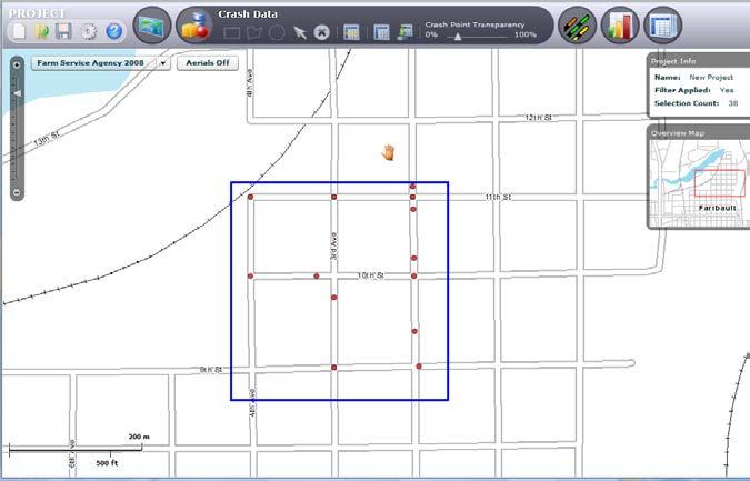
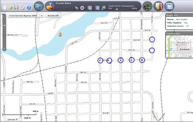
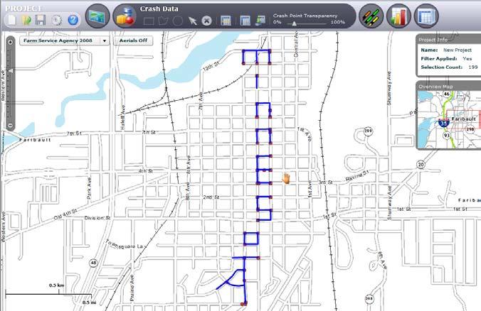
6 Basic MnCMAT Crash Analysis Process Step 1 Select Area to be Analyzed
7 MnCMAT Data Covers Entire State Primary Selection by County, District, Tribal Government, or State Multiple Secondary Selection Methods Rectangle Polygon Circle Roadway Segments

8 State Wide Selection
9 MnCMAT Data Covers Entire State Primary Selection by County, District, Tribal Government, or State Multiple Secondary Selection Methods Rectangle Polygon Circle Roadway Segments
10 Single County Selection

11 Multiple County Selection

12 County Selection
13 MnCMAT Toolbars
14 MnCMAT Data Covers Entire State Primary Selection by County, District, Tribal Government, or State Multiple Secondary Selection Methods Rectangle Polygon Circle Roadway Segments

15 Selection Methods

16 Select Location with Find Location Selection County City Intersection Crash Number XY Coordinate

17 Crash Data Using Stacks
18 Basic MnCMAT Crash Analysis Process Step 1 Select Area to be Analyzed Step 2 Apply Filtering Criteria

19 Filter Selection
20 Filter Categories City Contributing Factor 1 Contributing Factor 2 County Crash Diagram Crash Severity Day of Month Day of Week Driver Age Driver Condition Driver Gender First Harmful Event Investigating Officer Light Condition MnDOT District Month Number of Fatalities Number of Vehicles Relation to Intersection Reliability of Information Road Design Roadway Character Speed Limit Surface Conditions System Class Time of Day Traffic Control Device Travel Direction Tribal Govt. Type of Crash Type of Work Zone Vehicle Action Vehicle Travel Direction Vehicle Type Weather Conditions Year

21 Active Filter Selection Statistics
22 Filters Within MnCMAT Select the data applicable to the situation of interest. Single or multiple filters may be applied. Each filter provides AND logic between filter categories and OR logic within each filter

23 Filters Within MnCMAT OR AND
24 Basic MnCMAT Crash Analysis Process Step 1 Select Area to be Analyzed Step 2 Apply Filtering Criteria Step 3 Generate Output Maps Charts Reports Data Files
25 Graphical Outputs
26 View of Crash Incidents in Larger Area

27 Wide Area Crash Locations with Stacks
28 Data Exports

29 Crash Data Exports as a CSV or Shape File

30 Crash Data Exported as a CSV or Shape File
31 Charts

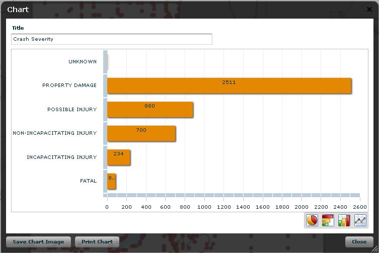
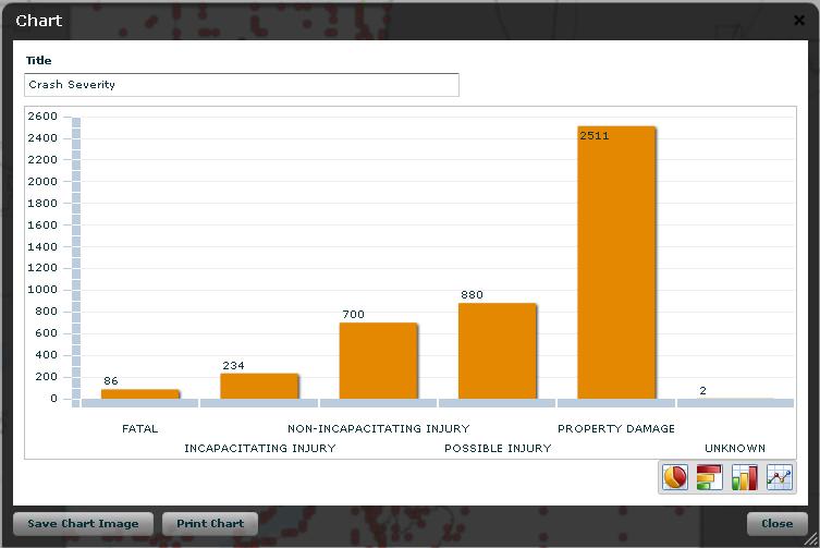
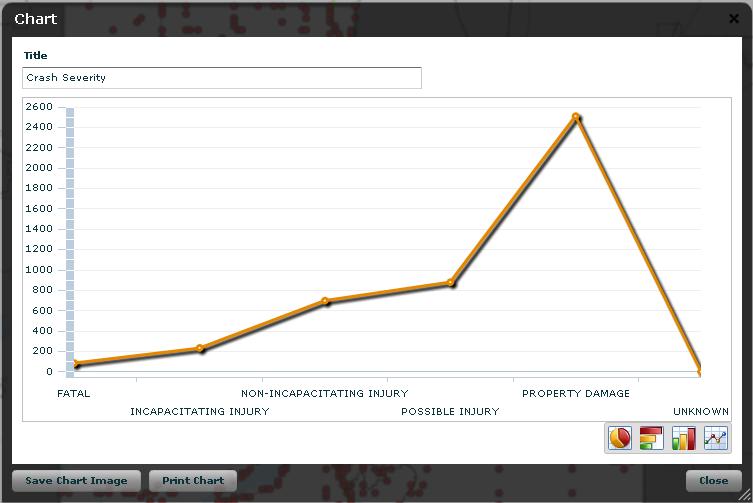
32 Crash Severity

33 Day of Week
34 Reports
35 Summary Report
36 Detail Report
37 Crash Type Summary Report
38 Driver and Time Summary

39 Top 100 Intersections Report
40 MnCMAT Distribution Being Supplied by MnDOT State Aid No additional software required No Cost to City or County Agencies or Other Entities Approved by a City or County

41 Approval Form for Use

42 MnCMAT s Website
43 DISCLAIMER The State, County and Municipal Transportation Authorities of Minnesota make no representation or warranties, express or implied, with respect to the reuse of the data provided herewith, regardless of its format or means of its transmission. There is no guarantee or representation to the user as to the accuracy, currentness, suitability, or reliability of this data for any purpose. The user accepts that data as is, and assumes all risks associated with its use. The State, County and Municipal Transportation Authorities of Minnesota assume no responsibility, actual or consequential damage, as a result of any user s reliance of this data. By submitting this form, you are stating that you understand that this application is only a tool and that Engineering Judgment must be used when interpreting all data. You are also agreeing that you understand that the data set used by this program is subject to errors and changes, therefore not to be assumed as absolute. The Minnesota Department of Transportation, State Aid Division maintains all rights to this application and may revoke your privileges of use at any time.
44 Minnesota 2 141,000 miles of Roadway 900 miles of Interstate 1 11k miles of Trunk Highway 45k miles of County Road k miles of City Streets 62k miles of Township/Other roads Killed and Seriously Injured 368 Fatalities (334 crashes) 1,159 Severe Injuries (954 crashes)

45 Wright County All Crashes
46 Wright County Fatal and Serious Crashes
47 HSIP Program Challenge to determine where to focus safety funds Black spots are infrequent on local roads Fatal and Severe injury crashes are random on local roads County Roads 2,089 Severe Crashes 45,000 miles of road 0.05 severe crashes per mile Trunk Highway 2,168 Severe Crashes 12,000 miles of road 0.18 severe crashes per mile

48 Surrogates Heart Disease Smoking Obesity Cholesterol Blood pressure Physical activity Stress Age/sex/heredity Surrogates for severe crashes? Segments, Intersection, Run off Road Crashes


49 Rural Thru STOP Intersection Risk Rating Criteria Characteristics Geometry Skewed minor leg approach Intersection on/near horizontal curve Volume Minor ADT/Major ADT ratio Proximity Previous STOP sign Railroad crossing Intersection Related Crashes Commercial Development in quadrants

 # Curves (11445 total) Severe RD (219")
50 Rural Horizontal Curve Risk Rating Criteria Curve Radius (all ATPs) 18% 16% 16% Characteristics 14% 13% 12% Curve Radius Traffic Volume Intersection Visual Trap Severe Crash Percentage 11% 11% 10% 10% 9% 8% 8% 7% 6% 6% 4% 4% 4% 4% 4% 3% 4% 2% 6% 5% 0% 0% 8% 7% 6% 6% 4% 4% 4% 4% 4% 4% 3% 2% 1% 1% 3% 2% 2% 2% 0% 2% 2% 1% 1% 0% Radius (ft) # Curves (11445 total) Severe RD (219 total)
51 Rural Road Segment Risk Rating Criteria Characteristics Traffic Volume Access Density Edge Risk Assessment Curve Density Crash Density (786 crashes)


52 Rural Road Segment Risk Rating Criteria (Part 2) Edge Risk Assessment 1 Usable Shoulder, Reasonable Clear Zone 2 -No Usable Shoulder but Reasonable Clear Zone 2 Usable Shoulder but Roadside with Fixed Obstacles 3 No Usable Shoulder, Roadside with Fixed Obstacles

53 Do the Rating Criteria Really Identify At-Risk Locations? Curve Risk Criteria Intersection Risk Criteria Crashes per Intersection Risk factor was present Risk factor was not present RR Crosing Development Skew On/Near Curve Greater than 5 mi. to Previous Stop Phase I and II Curves 3,990 curves included in analysis of each risk factor. Minimum of 1,500 curves and 76 severe crashes in each category Phase I and II - 5,725 intersections included in analysis of each risk factor. Minimum of 150 intersections and 16 severe crashes in each category
54 Rural Thru-STOP/YIELD Intersections Maximum of 7 s 10,082 Intersections evaluated
55 Rural Thru-STOP/YIELD Intersections Maximum of 7 s 10,082 Intersections evaluated 2,893 high priority 29%
56 Rural Paved Roadways Maximum of 5 s 21,451 miles evaluated
57 Rural Paved Roadways Maximum of 5 s 21,451 miles evaluated 8,177 miles High Priority 38% of all evaluated
58 Rural Paved Horizontal Curves Maximum of 5 s 16,522 curves evaluated

59 Rural Paved Horizontal Curves Maximum of 5 s 16,522 curves evaluated 2,744 curves High Priority 17% of all evaluated
60 Low Cost High Benefit Systemic Approach to Safety Deploy at locations having multiple risk factors Risk factor does not equal cause Safety Program Reacting to high crash locations Preventing crashes from occurring
61 Traffic Volume Program Estimates volumes at 33,000 locations 4,500 Trunk Highways 13,500 County State Aid Highway 6,500 County Roads 8,500 Municipal State Aid Streets
62 Data Collection Methods 32,500+ Short Counts 1,200+ Vehicle Classification sites 70+ Automatic Traffic Recorders 15+ Weigh In Motion systems 240+ Continuous counting sites
63 Data Collection Most of data collected by MnDOT staff Some cities/counties collect data (metro) Collection cycles 2 years for Trunk Highways 4 years for County Roads MnDOT stores and adjusts data
64 Questions?
Lessons Learned from the Minnesota County Road Safety Plans. Richard Storm CH2M HILL
 Lessons Learned from the Minnesota County Road Safety Plans Richard Storm CH2M HILL May 21, 2014 Overview of the MN CRSP: Why Prepare Safety Plans for Local Systems? MAP-21: Requires states to address
Where Did the Road Go? The Straight and Narrow about Curves
 Where Did the Road Go? The Straight and Narrow about Curves Renae Kuehl, SRF Consulting Group October 23, 2018 What is a County Roadway Safety Plan or CRSP?" CRSP Identifies priority location-specific
Chapter 5 DATA COLLECTION FOR TRANSPORTATION SAFETY STUDIES
 Chapter 5 DATA COLLECTION FOR TRANSPORTATION SAFETY STUDIES 5.1 PURPOSE (1) The purpose of the Traffic Safety Studies chapter is to provide guidance on the data collection requirements for conducting a
Phase I-II of the Minnesota Highway Safety Manual Calibration. 1. Scope of Calibration
 TECHNICAL MEMORANDUM Phase I-II of the Minnesota Highway Safety Manual Calibration PREPARED FOR: PREPARED BY: Minnesota Department of Transportation Richard Storm, CH2M HILL Veronica Richfield, CH2M HILL
Safety Data Resources. Multi-Discipline Safety Planning Forum March 10 & 11, 2008 Gateway Center
 Safety Data Resources Multi-Discipline Safety Planning Forum March 10 & 11, 2008 Gateway Center Tom McDonald, PE Safety Circuit Rider Iowa LTAP Jack Latterell,, PE Safety Consultant FHWA Safety Engineer,
VDOT Crash Analysis Procedures for Roadway Safety Assessments
 Crash analysis is a critical component of road safety analysis. The crash analysis procedures defined in this document will help: Identify where to target resources for detailed crash analysis Assess the
Safety Assessment of Installing Traffic Signals at High-Speed Expressway Intersections
 Safety Assessment of Installing Traffic Signals at High-Speed Expressway Intersections Todd Knox Center for Transportation Research and Education Iowa State University 2901 South Loop Drive, Suite 3100
ANALYSIS OF RURAL CURVE NEGOTIATION USING NATURALISTIC DRIVING DATA Nicole Oneyear and Shauna Hallmark
 ANALYSIS OF RURAL CURVE NEGOTIATION USING NATURALISTIC DRIVING DATA Nicole Oneyear and Shauna Hallmark OUTLINE Background Objective Data Sources Site Selection Data Reduction Future work Benefits BACKGROUND
Fatal Head-On Crashes on. Rural Two-Lane Two-Way Highways in Minnesota
 Fatal Head-On on Rural Two-Lane Two-Way Highways in Minnesota A Report Submitted to the Minnesota Department of Transportation By Derek Leuer, PE Office of Traffic, Safety, and Technology Minnesota Department
Update MnDOT s County Roadway Safety Plans 2012 Traffic Records Forum Biloxi, MS October 29, 2012 Brad Estochen
 Update MnDOT s County Roadway Safety Plans 2012 Traffic Records Forum Biloxi, MS October 29, 2012 Brad Estochen MnDOT, CH2M HILL, SRF Consulting Group, P.E. Services 1 County Road Safety Plans Funding
Traffic Accident Data Processing
 Traffic Accident Data Processing D o n a l d F. P e t t y Engineer of Traffic Research and Surveys Indiana State Highway Commission The following is a portion of the Highway Safety Program Standards developed
Sponsored by the Office of Traffic and Safety of the Iowa Department of Transportation NOVEMBER 2001 CTRE
 PAVED SHOULDERS ON PRIMARY HIGHWAYS IN IOWA: AN ANALYSIS OF SHOULDER SURFACING CRITERIA, COSTS, AND BENEFITS EXECUTIVE SUMMARY Sponsored by the Office of Traffic and Safety of the Iowa Department of Transportation
Safety Corridors a Synthesis. Charlie Nemmers / Derek Vap University of Missouri
 Safety Corridors a Synthesis Charlie Nemmers / Derek Vap University of Missouri 1 Background: Safety Corridors Study Need grew from a four State Safety Summit Funding from Iowa, Kansas, Missouri DOTs and
SUCCESFUL HSIP APPLICATIONS CUUATS & CHAMPAIGN COUNTY
 SUCCESFUL HSIP APPLICATIONS CUUATS & CHAMPAIGN COUNTY Traffic Engineering and Safety Conference October 15, 2014 CUUATS and Champaign County The Champaign-Urbana Urbanized Area Transportation Study (CUUATS)
Local Road Safety Plans
 An Introduction to Local Road Safety Plans June 21, 2018 Today s Presenter Jerry Roche, P.E. Safety Analysis Program Manager FHWA Office of Safety Ames, IA 2 NACE Do-It-Yourself LRSP Pilot Six states,
Design of Turn Lane Guidelines
 Design of Turn Lane Guidelines CTS Transportation Research Conference May 24, 2012 Howard Preston, PE Minnesota Department of Transportation Research Services Office of Policy Analysis, Research & Innovation
CE576: Highway Design and Traffic Safety
 CE576: Highway Design and Traffic Safety Predicting Crash Frequency for Two-Lane Rural Highway Segments Cross Sectional Elements Ahmed Abdel-Rahim, Ph.D., P.E. Civil Engineering Department University of
Local Rural Road Safety
 Local Rural Road Safety County State Aid Highway (CSAH) 5 Freeborn County, Minnesota National Surface Transportation Policy & Revenue Study Commission Testimony submitted by: Susan G. Miller, P.E. County
IHSDM- HSM Predictive Methods. Slide 1
 IHSDM- HSM Predictive Methods Slide 1 Presentation Outline IHSDM Overview Relationship between HSM and IHSDM Crash Prediction Models and Data Needs IHSDM HSM Predictive Method 2011 Release Preview Questions
Pavement Markings (1 of 3)
") Pavement Markings (1 of 3) DESCRIPTION AND DEFINITION Disadvantages Relatively high cost (over typical Crash reduction as yet unknown painted edge line) No tactile effect The STOP AHEAD pavement marking
Pavement Markings (1 of 3) DESCRIPTION AND DEFINITION Disadvantages Relatively high cost (over typical Crash reduction as yet unknown painted edge line) No tactile effect The STOP AHEAD pavement marking
ENGINEERING DRIVER SAFETY INTO PAVEMENT PRESERVATION
 ENGINEERING DRIVER SAFETY INTO PAVEMENT PRESERVATION 2015 TxDOT Short Course Miguel Arellano, P.E. Austin District Pavement Engineer October 13, 2015 Table of Contents 1 Goals: Overall Reduction in Crashes
Bicycle - Motor Vehicle Collisions on Controlled Access Highways in Arizona
 Bicycle - Motor Vehicle Collisions on Controlled Access Highways in Arizona Analysis from January 1, 1991 to June 30, 2002 Richard C. Moeur, PE Traffic Design Manager, Northern Region Michelle N. Bina
1 2 I N T R O D U C T I O 6 G E N E R A L I N F O R M A T I O N. Across. 6. Knowledge communicated in a brief overview
 1 2 I N T R O D U C T I O N 3 4 5 6 G E N E R A L I N F O R M A T I O N 7 Across 6. Knowledge communicated in a brief overview ABBREVIATIONS & ACRONYMS AADT - ANNUAL AVERAGE DAILY TRAFFIC ADT - AVERAGE
Evaluation of M-99 (Broad Street) Road Diet and Intersection Operational Investigation
 Road Diet and Intersection Operational Investigation") Evaluation of M-99 (Broad Street) Road Diet and Intersection Operational Investigation City of Hillsdale, Hillsdale County, Michigan June 16, 2016 Final Report Prepared for City of Hillsdale 97 North Broad
Evaluation of M-99 (Broad Street) Road Diet and Intersection Operational Investigation City of Hillsdale, Hillsdale County, Michigan June 16, 2016 Final Report Prepared for City of Hillsdale 97 North Broad
Engineering Your Community Safe
 Engineering Your Community Safe Andi Bill Transportation Information Center thanks its partners for their support and assistance National Traffic Safety Goal Reasonable goal? Who s Involved? What can you
Highway 12 Safety Coalition
 Highway 12 Safety Coalition City of Wayzata, City of Long Lake, City of Orono, City of Medina, City of Maple Plain, City of Independence, City of Delano, City of Montrose, City of Waverly, City of Howard
NEIGHBORHOOD TRAFFIC CALMING POLICY
 NEIGHBORHOOD TRAFFIC CALMING POLICY I. PURPOSE The City of Kent continually strives to strengthen and protect its neighborhoods by improving the quality of life in residential areas. Traffic conditions
Township Signing Practices
 Township Signing Practices The average Minnesota township has approximately 30 miles of roadway with an average of 6 total traffic signs per mile (both directions) 1 At a replacement cost of approximately
Vision Zero High Injury Network Methodology
 Vision Zero High Injury Network Methodology DATA SETS USED: 1. Reportable crashes in Philadelphia from 2012-2016, available as open data through PennDOT 2. Street Centerline geographic layer, maintained
MONROE COUNTY NEW YORK
 MONROE COUNTY NEW YORK Intersection Accident Database Enhancement Project (UPWP 4380) FINAL January 2008 Prepared By: Prepared For: Bergmann Associates 200 First Federal Plaza 28 East Main Street Rochester,
REDUCING COLLISIONS AT HIGH CRASH LOCATIONS
 REDUCING COLLISIONS AT HIGH CRASH LOCATIONS Presented by Nazir Lalani P.E. Traffex Engineers Inc. N_lalani@hotmail.com ACCIDENTS AND SAFETY Why is safety important? Safety components Who is responsible?
Evaluating Road Departure Crashes Using Naturalistic Driving Study Data
 Evaluating Road Departure Crashes Using Naturalistic Driving Study Data Strategic Highway Research Program 2 Transportation Research Board Third Safety Research Symposium July 17 & 18, 2008 Research Team:
Pedestrians safety. ROAD SAFETY SEMINAR PIARC/AGEPAR/GRSP Lome, Togo October 2006 Lise Fournier, Canada-Qu
 Pedestrians safety ROAD SAFETY SEMINAR Lome, Togo October 2006 Lise Fournier, Canada-Qu Québec Contents WHO s data Risk factors Pedestrian needs Pedestrian facilities Conclusion Source: WHO WHO reports
Designing for Pedestrians: An Engineering Symposium. Rutgers University March 21, 2013
 Designing for Pedestrians: An Engineering Symposium Rutgers University March 21, 2013 The Problem 2 Pedestrian Fatalities Pedestrian Fatalities by Year in US (1994-2010) 6000 5000 4000 3000 2000 1000 0
usrap: An Innovation in Data-Driven Safety Analysis
 Est. Dec. 2014 usrap: An Innovation in Data-Driven Safety Analysis Presented by: Bruce Hamilton, Roadway Safety Foundation Doug Harwood, MRIGlobal Webinar Logistics Duration is 11:00 AM - 12:30 PM Mountain
Analysis of Run-Off-Road Crashes in Relation to Roadway Features and Driver Behavior
 Analysis of Run-Off-Road Crashes in Relation to Roadway Features and Driver Behavior Ertan Örnek University of Wisconsin, Madison Traffic Operations Lab 141 NW Barstow Street Waukesha, WI 53187 ornek@wisc.edu
RURAL HIGHWAY SHOULDERS THAT ACCOMMODATE BICYCLE AND PEDESTRIAN USE (TxDOT Project ) June 7, Presented by: Karen Dixon, Ph.D., P.E.
 June 7, Presented by: Karen Dixon, Ph.D., P.E.") RURAL HIGHWAY SHOULDERS THAT ACCOMMODATE BICYCLE AND PEDESTRIAN USE (TxDOT Project 0-6840) June 7, 2016 Presented by: Karen Dixon, Ph.D., P.E., TTI Team: Kay Fitzpatrick, Raul Avelar, & Subasish Das Project
RURAL HIGHWAY SHOULDERS THAT ACCOMMODATE BICYCLE AND PEDESTRIAN USE (TxDOT Project 0-6840) June 7, 2016 Presented by: Karen Dixon, Ph.D., P.E., TTI Team: Kay Fitzpatrick, Raul Avelar, & Subasish Das Project
CHAPTER 7 CIRCULATION
 CHAPTER 7 CIRCULATION A township s transportation network links its population with the surrounding communities. Transportation networks, including public and private, provide the means by which township
Safety Performance Management Target Setting. Data: Fatalities and Serious Injuries
 Safety Performance Management Target Setting Data: Fatalities and Serious Injuries David Adams Georgia DOT Tom Sills CBMPO Executive Summary Purpose of the Regulatory Action is to clarify the Moving Ahead
Geometric Categories as Intersection Safety Evaluation Tools
 Geometric Categories as Intersection Safety Evaluation Tools John R. Campbell Ayres Associates N19 W24075 Riverwood Drive, Suite 300 Waukesha, WI 53188 campbellj@ayresassociates.com Keith K. Knapp Engineering
Systemic Safety Project Selection Tool
 Systemic Safety Project Selection Tool Presented by: Karen Scurry Federal Highway Administration Office of Safety Howard Preston CH2M HILL May 28, 2013 Today s presentation Introduction and housekeeping
Owl Canyon Corridor Project Overview and Summary
 Owl Canyon Corridor Project Overview and Summary December 22, 2008 The Owl Canyon corridor (generally the connection between the I-25 / Larimer County Road 70 interchange and the US 287 / Larimer County
4.0 IDENTIFICATION OF DEFICIENCIES
 4.0 IDENTIFICATION OF DEFICIENCIES 4.1 PERFORMANCE MEASURES AND RESULTS OF ANALYSIS 4.1.1 Roadway Safety As documented in Chapter 3, there were four key factors that were used to analyze the occurrence
Monroe County Department of Transportation Vertical Curve Safety Study
 Monroe County, New York PREPARED FOR: Monroe County Department of Transportation 50 West Main Street Suite 6100 Rochester, NY 14614 PREPARED BY: 255 East Avenue Rochester, New York 14604 project # 434934
Railroad Inspection Procedure Manual
 Railroad Inspection Procedure Manual Railroad Inspection Procedure Manual Table of Contents Introduction... 1 Inspection Report t For orm... 3 Instructions for Completing Inspection Report t For orms...
Multimodal Design Guidance. October 23, 2018 ITE Fall Meeting
 Multimodal Design Guidance October 23, 2018 ITE Fall Meeting Introductions Jessica Wilson TDOT Multimodal Division Office of Multimodal Planning Program Supervisor Jessica.L.Wilson@tn.gov Ali Hangul TDOT
Traffic Signs (1 of 3)
") Traffic Signs (1 of 3) DESCRIPTION AND DEFINITION 5. Initiate Projects Implement sign upgrade projects and consider sign removal. In the analytical process to determine an agency s annual sign maintenance
Traffic Signs (1 of 3) DESCRIPTION AND DEFINITION 5. Initiate Projects Implement sign upgrade projects and consider sign removal. In the analytical process to determine an agency s annual sign maintenance
Road Safety Audit Review
 U.S. Highway 14: Mankato to New Ulm Road Safety Audit Review Technical Report April 17, 2012 Prepared By 1.0 INTRODUCTION... 2 1.1 ROAD SAFETY AUDIT REVIEW (RSAR) TEAM... 2 1.2 ROAD SAFETY AUDIT REVIEW
Implementing Strategies from Missouri s Blueprint for Safer Roadways Using System-wide Safety Solutions to Save Lives
 Implementing Strategies from Missouri s Blueprint for Safer Roadways Using System-wide Safety Solutions to Save Lives John Schaefer Sr. Traffic Studies Specialist Missouri Department of Transportation
Town of Orangetown Neighborhood Traffic Calming Program
 Town of Orangetown Neighborhood Traffic Calming Program Table of Contents I Introduction a. Purpose b. Key to successful projects c. What is Traffic Calming? II III IV V VI VII Definitions Street Classification
2012 TOWN OF CASTLE ROCK MOTOR VEHICLE ACCIDENT FACTS PREPARED BY THE PUBLIC WORKS DEPARTMENT
 ATTACHMENT A 2012 TOWN OF CASTLE ROCK MOTOR VEHICLE ACCIDENT FACTS PREPARED BY THE PUBLIC WORKS DEPARTMENT ACKNOWLEDGEMENTS This report was assembled from data provided by the Castle Rock Police Department
FHWA Resources for Pedestrian and Bicycle Professionals
 FHWA Resources for Pedestrian and Bicycle Professionals Charlie Zegeer, UNC Highway Safety Research Center/PBIC Libby Thomas, UNC Highway Safety Research Center Dan Nabors, Vanasse Hangen Brustlin (VHB)
An Overview of Traffic Records. April 15, 2016 John Riemer
 An Overview of Traffic Records April 15, 2016 John Riemer What is traffic records? The traffic records office is required by state statue to maintain a database of motor vehicle crashes that occur on all
Bi-state metropolitan planning organization (MPO)
") Using a Variety of Data to Identify Locations of Concern in a Transportation Network 3 th Annual MN APA State Planning Conference September, 8 Robert Herling, Planner Duluth-Superior Metropolitan Interstate
Using a Variety of Data to Identify Locations of Concern in a Transportation Network 3 th Annual MN APA State Planning Conference September, 8 Robert Herling, Planner Duluth-Superior Metropolitan Interstate
Development of Criteria to Identify Pedestrian High Crash Locations in Nevada. Quarterly Progress Report. Submitted to
 Development of Criteria to Identify Pedestrian High Crash Locations in Nevada Submitted to Nevada Department of Transportation (NDOT) Research Division 1263 South Stewart Street Carson City, NV 89712 Krishna
To Illuminate or Not to Illuminate: Roadway Lighting as It Affects Traffic Safety at Intersections
 To Illuminate or Not to Illuminate: Roadway Lighting as It Affects Traffic Safety at Intersections Mark Rea Lighting Research Center Rensselaer Polytechnic Institute Eric Donnell Dept. of Civil and Environmental
MRI-2: Integrated Simulation and Safety
 MRI-2: Integrated Simulation and Safety Year 3 2 nd Quarterly Report Submitted by: Dr. Essam Radwan, P.E. (PI), Ahmed.Radwan@ucf.edu Dr. Hatem Abou-Senna, P.E., habousenna@ucf.edu Dr. Mohamed Abdel-Aty,
Creating a Successful Pedestrian Safety Campaign. St. Paul, MN
 Creating a Successful Pedestrian Safety Campaign St. Paul, MN - 2015-2017 The Problem The Problem A pedestrian or bicyclist is struck by a vehicle every other day in St. Paul (.84 per day) This doesn t
HSIS. Association of Selected Intersection Factors With Red-Light-Running Crashes. State Databases Used SUMMARY REPORT
 HSIS HIGHWAY SAFETY INFORMATION SYSTEM The Highway Safety Information Systems (HSIS) is a multi-state safety data base that contains accident, roadway inventory, and traffic volume data for a select group
Systemic Safety. Doug Bish Traffic Services Engineer Oregon Department of Transportation March 2016
 Systemic Safety Doug Bish Traffic Services Engineer Oregon Department of Transportation March 2016 Oregon averages 1700 fatal and serious injury crashes each year. Some of the more common crash types include:
Olmsted County Highway Safety Plan
 TB072009008MKE Olmsted County Highway Safety Plan September 2009 Submitted to: Table of Contents 1. Introduction...1-1 2. Comprehensive Crash Analysis...2-1 3. Safety Emphasis Areas...3-1 4. Safety Strategies...4-1
What Engineering Can Do for You! Low Cost Countermeasures for Transportation Safety
 What Engineering Can Do for You! Low Cost Countermeasures for Transportation Safety Adam Larsen Safety Engineer Federal Highway Administration 360-619-7751 Adam.Larsen@DOT.GOV Adam Larsen TTP Safety Engineer
NEW YORK STATE 2018 Observational Survey of Seat Belt Use
 NEW YORK STATE 2018 Observational Survey of Seat Belt New York State Governor s Traffic Safety Committee Chuck DeWeese, Assistant Commissioner Empire State Plaza Albany, New York 12228 NEW YORK STATE
road safety issues 2001 road toll for Gisborne district July 2002 Road user casualties Estimated social cost of crashes*
 GISBORNE DISTRICT road safety issues July 22 The Land Transport Safety Authority (LTSA) has prepared this Road Safety Issues Report. It is based on reported crash data and trends for the 1997 21 period.
Kentucky s Surface Transportation System
 Kentucky s Surface Transportation System ROAD AND BRIDGE CONDITIONS, TRAFFIC SAFETY, TRAVEL TRENDS, AND NEEDS MARCH 2018 PREPARED BY WWW.TRIPNET.ORG Founded in 1971, TRIP of Washington, DC, is a nonprofit
Safety Performance of Two-Way Stop-Controlled Expressway Intersections
 Safety Performance of Two-Way Stop-Controlled Expressway Intersections UNDERSTANDING THE SAFETY PERFORMANCE OF TWO-WAY STOP- CONTROLLED RURAL EXPRESSWAY INTERSECTIONS WILL HELP CORRIDOR PLANNERS AND DESIGNERS
Table of Contents Kansas Highway Safety Improvement Program
 KANSAS Page 1 of 54 Table of Contents Table of Contents... 2 Disclaimer... 3 Executive Summary... 4 Introduction... 5 Program Structure... 5 Program Administration... 5 Program Methodology... 8 Project
7 DESIGN CRITER RIA 7.1 Design Space Requirements
 7 DESIGN CRITERIA 7.1 Design Space Requirements The Nebraskaa Department of Roads (NDOR) provided examples of intersections where an approved guardrail end terminal and Approach Guardrail Transition (AGT)
NDDOT TRAFFIC OPERATIONS MANUAL
 Prepared By: North Dakota Department of Transportation Programming Division Traffic Operations Section June 05 Table of Contents TRAFFIC OPERATIONS OVERVIEW... 3 TRAFFIC OPERATIONS STUDIES RURAL SEGMENTS
SHRP 2. Strategic Highway Research Program. Accelerating solutions for highway safety and performance. Charles Fay, Sr.
 Strategic Highway Research Program SHRP 2 Accelerating solutions for highway safety and performance Charles Fay, Sr. Program Officer GIS-T Boise, ID 2013 Second Strategic Highway Research Program ( SHRP
Methods to Reduce Traffic Speed in High Pedestrian Areas. Revised Work Plan
 Methods to Reduce Traffic Speed in High Pedestrian Areas Revised Work Plan Principal Investigators Ali Kamyab Gary Thomas Center for Transportation Research and Education (CTRE) 2901 South Loop Drive,
Northbound San Jose Avenue & I-280 Off-Ramp Road Diet Pilot Project
 Project Overview Fed by a two-lane Interstate-280 (I-280) off-ramp, high vehicular volumes and speeds are longstanding issues along San Jose Avenue. Residents in the surrounding neighborhoods have expressed
DEFINITIONS Activity Area - Advance Warning Area Advance Warning Sign Spacing Advisory Speed Approach Sight Distance Attended Work Space
 DEFINITIONS Activity Area - that part of a TTC zone activity area where the work actually takes place. It consists of the work space, traffic space and one or more buffer spaces. Advance Warning Area -
GIS Based Non-Signalized Intersection Data Inventory Tool To Improve Traffic Safety
 GIS Based Non-Signalized Intersection Data Inventory Tool To Improve Traffic Safety UNIVERSITY OF ALABAMA JENNA SIMANDL JENNY BLEIHOLDER ANDREW GRAETTINGER TIM BARNETT LUKE TAYLOR RANDY SMITH Introduction
Emerging Crash Trend Analysis. Mark Logan Department of Main Roads, Queensland. Patrick McShane Queensland Transport
 Emerging Crash Trend Analysis Mark Logan Department of Main Roads, Queensland Patrick McShane Queensland Transport The authors would like to acknowledge the assistance of Queensland Transport's Data Analysis
City of Wayzata Comprehensive Plan 2030 Transportation Chapter: Appendix A
 A1. Functional Classification Table A-1 illustrates the Metropolitan Council s detailed criteria established for the functional classification of roadways within the Twin Cities Metropolitan Area. Table
Napier City road trauma for Napier City. Road casualties Estimated social cost of crashes* Major road safety issues.
 ISSN 1176-841X July 25 Land Transport New Zealand has prepared this road safety issues report. It is based on reported crash data and trends for the 2 24 period. The intent of the report is to highlight
Pedestrian and Bicycle Crashes
 Pedestrian and Bicycle Crashes Pedestrian and Bicycles Overview Pedestrian-related crashes represent 3.6% of the total reported traffic crashes; however, they account for 11.1% of all traffic crash deaths.
Guidelines for Integrating Safety and Cost-Effectiveness into Resurfacing, Restoration, and Rehabilitation Projects
 Guidelines for Integrating Safety and Cost-Effectiveness into Resurfacing, Restoration, and Rehabilitation Projects NCHRP Project 15-50 July 2017 1 Research Objective Develop guidelines for safe and cost-effective
Department of Transportation
 Department of Transportation I. Internal Scan The number of older drivers in the United States will double over the next 30 years. By 2030 one in five Americans will be age 65 or older. On a licensed-driver
12 RECOMMENDATIONS Road Improvements. Short Term (generally the next five years)
") 12 RECOMMENDATIONS Recommendations are based on the technical analysis of existing and future road and active transportation conditions, the results of the review of existing City policies and public feedback.
12 RECOMMENDATIONS Recommendations are based on the technical analysis of existing and future road and active transportation conditions, the results of the review of existing City policies and public feedback.
Automated Traffic Enforcement Technology Guidelines
 Automated Traffic Enforcement Technology Guidelines Province of Alberta (September 2014) Revised Automated Traffic Enforcement Technology Guidelines Province of Alberta A. PREAMBLE Automated traffic enforcement
SCHOOL CROSSING PROTECTION CRITERIA
 CITY OF MADISON TRAFFIC ENGINEERING SCHOOL CROSSING PROTECTION CRITERIA AUGUST 1990 Adopted as Policy on August 31, 1976, by Common Council by Amended Resolution #29,540 Amended on September 14, 1976,
Bureau of Planning and Research. Project No.: (C14) Phase II Final Report March 2, 2007 CMA
 Phase II Final Report March 2, 2007 CMA") Bureau of Planning and Research Safer Driver Actions at Stop Signs Project No.: 04-01 (C14) Phase II Final Report March 2, 2007 CMA Technical Report Documentation Page 1. Report No. 2. Government Accession
Bureau of Planning and Research Safer Driver Actions at Stop Signs Project No.: 04-01 (C14) Phase II Final Report March 2, 2007 CMA Technical Report Documentation Page 1. Report No. 2. Government Accession
the Ministry of Transport is attributed as the source of the material
 Cyclists 2015 Disclaimer All reasonable endeavours are made to ensure the accuracy of the information in this report. However, the information is provided without warranties of any kind including accuracy,
THE FUTURE OF THE TxDOT ROADWAY DESIGN MANUAL
 THE FUTURE OF THE TXDOT ROADWAY DESIGN MANUAL Kenneth Mora, P.E. (Design Division) 10/10/2017 Table of contents 1 2 Reduction in FHWA design controlling criteria Innovative Intersection Guidance 3-7 8-42
Planning Guidance in the 2012 AASHTO Bike Guide
 Planning Guidance in the 2012 AASHTO Bike Guide Presentation by: RJ Eldridge Peter Lagerwey August 22, 2012 WEBINAR 2: PLANNING GUIDANCE IN THE 2012 AASHTO BIKE GUIDE Today s Webinar Significant Updates
Reducing Crashes at Rural Thru-STOP Controlled Intersections
 Reducing Crashes at Rural Thru-STOP Controlled Intersections Howard Preston and Richard Storm CH2M Hill 1380 Corporate Center Curve, Suite 200 Eagan, MN 55121 hpreston@ch2m.com, richard.storm@ch2m.com
ADOT Statewide Bicycle and Pedestrian Program Summary of Phase IV Activities APPENDIX B PEDESTRIAN DEMAND INDEX
 ADOT Statewide Bicycle and Pedestrian Program Summary of Activities APPENDIX B PEDESTRIAN DEMAND INDEX May 24, 2009 Pedestrian Demand Index for State Highway Facilities Revised: May 29, 2007 Introduction
Colorado Department of Transportation Crash Data Program Alisa Babler, PE
 Colorado Department of Transportation Crash Data Program Alisa Babler, PE 2014 Colorado 115,388 Total Crashes 39,353 Injuries 488 Fatalities 489.85 100MVMT 88,258 Roadway Center Line Miles Media Question:
GUIDELINES FOR USING DECISION SIGHT DISTANCE AT IGNALIZED INTERSECTIONS NEAR VERTICAL CURVES
 1. Report No. FHWA/TX-05/0-4084-P2 4. Title and Subtitle 2. Government Accession No. 3. Recipient's Catalog No. GUIDELINES FOR USING DECISION SIGHT DISTANCE AT IGNALIZED INTERSECTIONS NEAR VERTICAL CURVES
G AT E WAY PLAN. Community BRIEFING KIT GATEWAY BIKE
 G AT E WAY PLAN GATEWAY BIKE Community BRIEFING KIT PLAN August 2016 TABLE OF CONTENTS INTRODUCTION... 1 THE BENEFITS OF A BIKEABLE COMMUNITY... 2 ECONOMY...2 SAFETY...3 HEALTH...3 HOUSEHOLD SPENDING...3
Roadway Conditions as Contributing Factors in Florida Traffic Crashes
 Roadway Conditions as Contributing Factors in Florida Traffic Crashes Michael R. Baltes and Xuehao Chu Center for Urban Transportation Research University of South Florida 4202 East Fowler Avenue, CUT
Traffic Signal Redesign 50% Design Report
 Traffic Signal Redesign 50% Design Report Joseph Davis, Jace Elkins, Jordan Weyrauch and Zach Crimmins CENE 486 Capstone J3Z Engineering March 10 th, 2016 Table of Contents 1.0 Project Description...1
Le Sueur County, MN Tuesday, December 13, 2016 Board Meeting
 Le Sueur County, MN Tuesday, December 13, 216 Board Meeting Item 8 1:15 a.m. Darrell Pettis, County Administrator / Engineer RE: Final CSAH 3 RE: CSAH 29 Speed Zone Study RE: 4H Utilities RE: Lake Jefferson
SCHOOL CROSSING PROTECTION CRITERIA
 CITY OF MADISON TRAFFIC ENGINEERING SCHOOL CROSSING PROTECTION CRITERIA January 2016 Adopted as Policy on August 31, 1976, by Common Council by Amended Resolution #29,540 Amended on September 14, 1976,
Highway Safety Improvement Program. Metro District Program Criteria
 HSIP Highway Safety Improvement Program Metro District Program Criteria Minnesota Department of Transportation Metro District Traffic Engineering September 2014 Table of Contents Introduction... 1-2 Qualifying
Description of Road Management Objectives, Existing Use, and Proposed Use:
 Engineering Report White River National Forest Eagle-Holy Cross Ranger District Analysis of Road # 700 Red Sandstone Road for Motorized Mixed Use Designation Page 1 of 12 Forest: White River District:
DESIGN MEMORANDUM WITH DESIGN EXCEPTIONS SP SP
 DRAFT NOT FINAL (Note: document was not finalized due to an eastbound stopping site distance design issue that requires more detailed bridge and roadway design considerations. This discussion starts on
RESOLUTION NO ?? A RESOLUTION OF THE CITY OF NEPTUNE BEACH ADOPTING A COMPLETE STREETS POLICY
 RESOLUTION NO. 2018-?? A RESOLUTION OF THE CITY OF NEPTUNE BEACH ADOPTING A COMPLETE STREETS POLICY WHEREAS, safe, convenient, and accessible transportation for all users is a priority of the City of Neptune