Monroe County Department of Transportation Vertical Curve Safety Study
|
|
|
- Joanna Bishop
- 5 years ago
- Views:
Transcription


1 Monroe County, New York PREPARED FOR: Monroe County Department of Transportation 50 West Main Street Suite 6100 Rochester, NY PREPARED BY: 255 East Avenue Rochester, New York project #
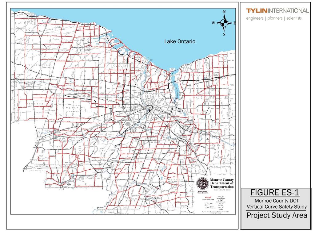
2 1.0 Executive Summary The Monroe County was initiated by the Monroe County Department of Transportation (MCDOT) to identify/investigate all vertical curve locations within the County. Monroe County Department of Transportation owns and maintains approximately 274 roads within the County, containing 663 centerline miles. The purpose of this is to identify non-standard vertical curves on County roads and to evaluate non-standard vertical curve locations within the County that have a history of safety concerns. Non-standard vertical curves do not meet the minimum sight distance requirements for a crest vertical curve as defined by the American Association of State Highway and Transportation Officials (AASHTO). The study scope and parameters have been developed in consultation with Monroe County and the MCDOT point system for prioritizing vertical curves and the procedures conform to guidelines recommended by AASHTO. The intent is to identify vertical curves where improvements are proposed for consideration by Monroe County. The overall project study area included all County Route roadways and intersections within Monroe County. Figure ES-1 identifies the roadways studied. Using data supplied by MCDOT, an inventory of vertical curve locations was compiled and rated based on a series of factors. Key factors include high incidents of accidents in the areas where the vertical curves are located, and stopping sight distances that are less than values recommended by AASHTO for the roadway s 85 th percentile speeds. Locations that met the criteria were highlighted for further investigation. Survey data was used to further investigate the effect of each vertical curve location on stopping sight distance and to determine a list of locations for recommended remediation. The steps taken to complete the project analysis are previewed below and identified in Figure ES-2. A predetermined series of Filters was used to pinpoint the High priority Candidate Vertical Curve Locations that were recommended for mitigation. A brief description of each filter is summarized below; further discussion follows within the text of this section. ES-1
3 ES-2


4 The process used to complete the project analysis is illustrated in Figure ES-2. Figure ES-2 Filter Flowchart to Identify High Priority Candidate Vertical Curve Locations Identification of all Monroe County Links and Nodes Filter A 3 yr Accident Rate/ Average Accident Rate Ratio > 1 No Yes Filter B Safety Score >11 No Yes Filter C Locations Mitigated Profile Check Indicates Non- Standard Sight Distance near the Crest No No Further Action Yes Develop Recommendations Filter D Indicate Locations and Review Detailed Accident Reports Video Check Indicates Sight Distance may be Limited No Filter F Field Measurement Confirm VC Yes Filter E Figure ES-2 No ES-3
5 Filter A Accident Ratio Comparison 1. A total of 1,678 nodes and 2,803 links for a total of 4,481 locations were identified within the County Route road system. 2. A spreadsheet was created to track the entries associated with each location. 3. The accident rates for reportable accidents for each link and the average accident rates were identified. 4. The ratio between the Average Three Year Accident Rate and the Average Accident Rate was calculated. 5. All locations with ratios greater than or equal to one were identified as potential candidate locations and progressed to the next filter (Filter B). A total of 1,303 locations were progressed. Filter B Safety Score Determination 1. The total number of accidents where the terrain description included reference to a curve was logged for each location listed. The following roadway characteristic codes were transferred to the link calculation spreadsheet: 03 - Straight and Hillcrest 04 - Curve and Level 05 - Curve and Grade 06 - Curve and Hillcrest All accidents with curve codes were included in the analysis to encompass accidents located on a vertical curve that may have been miscoded in the accident report. 2. The Average Daily Traffic (ADT) volume was entered for each link. 3. The 85th Percentile speed was estimated and entered into the spreadsheet for each link identified in this filter. The speed limit plus 10 mph was used to estimate the 85th Percentile speed. 4. Terrain Navigator Pro software was used to determine the vertical curve locations for each location with an accident rating ratio greater than one. After the grade variations were confirmed in a later step, the SSD and ISD were measured and entered into the calculation sheet 5. A point system was developed considering the accidents, volume, speed and estimated sight distance. The total point value was evaluated for each location identified within this filter and sorted from highest to lowest. A total of 127 locations were identified with a safety score of eleven (11) or greater and, based on statistical analysis significance, were progressed to the next level (Filter C). Figure ES-3 outlines the point determinations scale used to determine the overall scores. Refer to Figure ES-4 for a breakdown of the total number of locations based on the overall total score value. ES-4
 - 0 points b. Less than ISD but exceeds stopping sight distance (SSD) - 2 points c. Less than minimum SSD - 4 points d.")

 a. Approach speed 45 MPH or more - 2 points b.")
6 Figure ES-3 - Scoring System for Vertical Curves 1. Estimated sight distance (0-6 points, add points as outlined below) a. Exceeds minimum intersection sight distance (ISD) - 0 points b. Less than ISD but exceeds stopping sight distance (SSD) - 2 points c. Less than minimum SSD - 4 points d. If the critical SD is less than ISD and an intersection exists - add 2 points 2. Reportable Only Accident Rates over Three Years (0-8 points) a. Less than average rate - 0 points b. Over average but closer to average than critical - 2 points c. Less than critical but closer to critical than average - 5 points d. Over the critical rate - 8 points 3. All accidents related to the Curve Over Three Years add 2 Points for each accident 4. Miscellaneous Factors (0-5 points, add points as outlined below) a. Approach speed 45 MPH or more - 2 points b. ADT (intersection ADT or linear ADT if at a driveway) over 1000 vpd - 1 point, over points, over points Note: A score of 11 or more points rates consideration for an improvement. Figure ES-4 Filter B Vertical Curve Point Distribution ES-5
7 Filter C USGS Profile Check The 127 locations isolated in the previous filter with the highest overall total point values were evaluated for sight distance with United States Geotechnical Survey (USGS) maps to isolate vertical curve locations. A total of 86 locations with potential sight distance issues were progressed to the next filter (Filter D). Filter D Video Check Vertical curve locations analyzed within this filter were verified with video. If the video inspection revealed limited sight distance over the vertical curve s crest and the safety score was eleven (11) or greater, the locations were further investigated. A total of 15 locations were progressed to the next filter (Filter E). Filter E Survey Check 1. Each of the 15 vertical curve locations was profiled with survey data using LIDAR to obtain detailed contour points. 2. Based on MCDOT speed data (which replaced the estimated 85th Percentile speed used in Filter B), the preferable Stopping Sight Distances (SSD) and Intersection Sight Distances (ISD) were overlaid onto each profile. 3. Out of the 15 locations analyzed with the video check, 14 were determined to have vertical curve crest profiles that conflict with the preferable Stopping Sight Distances (SSD) and Intersection Sight Distances (ISD). These 14 locations were progressed to the next filter (Filter F) for identification and mitigation recommendation. Filter F - Recommendations Short term and long term recommendations were considered and identified if appropriate for each of the vertical curve locations isolated within this filter. A total of 14 locations were detected and plotted on Geographic Information System (GIS) map to display the High Priority Candidate Vertical Curve Locations within the County. Within this filter, details of the MV104 accident reports were checked. Information pertaining to the type of accident, location of the vehicle(s) before the collision, traffic condition, light condition, weather, road surface condition, and collision type were investigated to isolate accident patterns and to determine corrective mitigation measures. Each candidate vertical curve location recommended for remediation through this filter was plotted on a GIS map to identify cluster locations and recommend mitigation measures to improve safety at the vertical curve. Figure ES-5 illustrates clusters of vertical curve locations with respect to the overall vertical curve locations identified in the beginning of this study. A majority of the High Priority Candidate Vertical Curve Locations recommended for mitigation are located on the southeast side of Monroe County in eight different towns. ES-6
8 Figure ES-5 includes a list of the 14 candidate vertical curve locations rated from highest priority to lowest priority based on the total overall score. Information pertaining to the road name and the location of the vertical curve are reported in this table. To remediate the High Priority Candidate Vertical Curve Locations within the County, a series of mitigation measures ranging from short term to long term are recommended. The mitigation measures recommended for each priority vertical curve location is intended to increase the existing sight distance and/or reduce the driver speeds while minimizing physical change to cross street profiles and driveway grading. Based on record data, survey data, geometrical configurations and surrounding terrain, short term and long term mitigation measures are suggested to improve current safety conditions for the candidate vertical curve locations. No Action Required At 8 of the 14 curve locations, the safety record indicates that the existing conditions are adequate, even though the sight distance may be limited. Warning signs are posted where required, passing is prohibited, and no accident patterns related to the curves were found. Short Term Mitigation Improvements such as new sign panels and passing zone restrictions can be implemented within a short period that may address and reduce the potential for accidents related to the vertical curve. The following short term mitigation measures can be applied immediately minimal planning: Passing zone restriction Elimination of existing passing zones within the vertical curve minimizes the potential for head on collisions. This measure is recommended for four locations as identified in Figure ES-6. Advisory speed limit plaque An advisory speed limit sign is used to supplement an intersection warning sign with a speed recommendation based on the operating characteristic and condition of the road section. As illustrated in Figure ES-6, a 40 MPH advisory speed is recommended in one location based on Manual on Uniform Traffic Control Devices for Streets and Highways (MUTCD) requirements. Intersection warning signs An Intersection warning sign is positioned before an intersection to notify the drive of an upcoming intersection and the possibility of turning or entering traffic. An intersection warning sign is recommended in one location based MUTCD requirements. ES-7

9 Vertical Curve Safety Stud ES-8
10 Long Term Mitigation Other safety enhancements require funding to be identified and to allocate design and construction time. The costs associated with each of the long term recommendations presented in this study are based on isolated locations. Spot improvements are typically more costly per linear foot to construct than more extensive construction projects. Therefore, it is recommended that the long term modifications outlined in this study be implemented during the next road improvement project opportunity. The following examples demonstrate long term improvements that facilitate improved maneuverability and/or enhanced sight distance: Widen shoulder sections Five (5) to eight (8) foot wide paved shoulders along both sides of the road provide a refuge area for parked vehicles or for a car to pass a stopped vehicle. Five (5) foot wide paved shoulders along both sides of the road improve the driver s maneuverability and ability to avoid a crash. Approximately twenty percent of the candidate vertical curve locations identified within this study are recommended for this type of mitigation. Profile adjustment Adjustments made to a vertical curve crest to lengthen the curve can increase the stopping sight distance within the vertical curve. Based on accident histories and the level of potential physical impacts and costs, profile adjustments are not recommended for the candidate vertical curve locations. A range of mitigation options and the projected costs associated with the improvements for the short term and long term time frames are identified in Figure ES-6. The table collectively represents the short term and long term recommendations for each of the 14 High Priority Candidate Vertical Curve Locations identified. An estimate of the cost (in current dollars) to implement each improvement is included in the table for Monroe County Department of Transportation s consideration. Conclusion Shoulder improvements are recommended in three locations. Canfield Road has a high occurrence of parking and pedestrian activity within the area of two vertical curves. The other two locations were selected based on high operating speeds within areas with ineffective shoulder sections limiting driver maneuverability. Out of the 4,481 link and node locations analyzed in this Report, 14 High Priority Candidate Vertical Curve Locations were identified. These locations were prioritized based on an overall score comprised of accident data, Annual Daily Traffic (ADT) volumes, 85 th percentile speed and stopping sight distances. Using a sensitivity analysis, an eleven (11) point cut-off value was identified. As such, based on the criteria used for this study, 14 High Priority Candidate Vertical Curve Locations are studied and 6 are recommended to Monroe County Department of Transportation for mitigation consideration. No action is required for the other 8. Specific locations are identified in Figure ES-6. ES-9
11 Figure ES-6 Table of Recommended Improvements Short Term Recommendations Long Term Recommendations Total Costs Road/Town Description Points Improvement Description Costs Improvement Description Costs per Location Comments 1 Canfield Road, Mendon V. C. "A" is approx. 2,050' west of Mendon Center Rd. 24 No Action Recommended $0 Install new 3,300 LF 8' wide shoulder on both sides of Canfield Road at Vertical A -B $584,430 V. C. "B" is approx. 1,460' west of Mendon Center Road. No Action Recommended $0 $0 $584,430 $584,430 Add a W2-2 "Intersection Warning" sign on Ayrault Road (EB), west of Willowick Drive $350 No Action Recommended $0 Two vertical curves exist within this section. Roadside parking occurs on the shoulder and pedestrian activity is high. The shoulder width and clear zone within the studied area is appropriate for the road and the actual stopping sight distance is within 5 feet of the recommended intersection sight distance. 2 Ayrault Road, Perinton Intersection of Ayrault Rd. and Willowick Dr. 23 $350 $0 $350 The road section within the proximity of the vertical curve is clearly signed/marked and the 3 Turk Hill Road, Perinton 460 ft south of Whisperwood Dr. 19 No Action Recommended $0 No Action Recommended $0 pavement section is adequate. 4 Turk Hill Road, Perinton 720 north of Ayrault Rd. 19 No Action Recommended $0 No Action Recommended $0 The road section is clearly signed/marked and the pavement section is appropriate for the road. The actual stopping sight distance is within 15 feet of the recommended stopping sight distance. 5 Middle Road, Henrietta 1,025 south of Erie Station Road 18 No Action Recommended $0 No Action Recommended $0 The road section is clearly signed/marked and the shoulder width and clear zone are appropriate for the road. Because several driveways are located within the vertical curve, there would be substantial impacts to adjust the profile. 6 Calkins Road, Henrietta Approximately 900 west of Henrietta-Pittsford Rd. 17 No Action Recommended $0 No Action Recommended $0 The road section is clearly signed/marked and the pavement section is appropriate for the road. 7 Boughton Hill Road, Mendon Approximately 1,000 east of West Bloomfield Rd. 16 Eliminate the existing eastbound passing zone within Install new 3,800 LF 6' wide shoulder on both the proximity of the curve (approximately 300'). $225 sides of Boughton Hill Road at the Vertical Curve $564,470 $225 $564,470 $564,695 Within the vertical curve section, a passing zone exists. The speed limit is 55 mph and the pavement section is narrow without a paved shoulder section. 8 Turk Hill Road, Perinton Approx. 500 north of Whisperwood Dr. 16 No Action Recommended $0 No Action Recommended $0 The road section within the vertical curve is clearly signed/marked and the shoulder width and clear zone are appropriate for the road. 9 North Road, Wheatland Approx. 1,100 west of Wheatland Center Road Morgan Road, Chili 1,340 east of Union Station 15 Install new 3,000 LF 5' wide shoulder on both Eliminate the existing westbound passing zone within the proximity of the curve (approximately 700'). sides of North Road between Cedar Ave. and $525 Wheatland Center Road $388,400 $525 $388,400 $388,925 Eliminate the existing eastbound passing zone within the proximity of the curve (approximately 400'). $300 No Action Recommended $0 Within the vertical curve section, a passing zone exists. The speed limit is 55 mph and the lane widths and shoulder sections are narrow. A passing zone is located within the vertical curve section and the shoulder width and clear zone are appropriate for the road. $300 $0 $ Ayrault Road, Perinton Approx. 800 east of Hogan Road 14 No Action Recommended $0 No Action Recommended $0 The road section is clearly signed/marked and the shoulder width and clear zone are appropriate for the road. 12 East River Road, Henrietta Intersection of East Henrietta Road and Brooks Rd. 14 No Action Recommended $0 No Action Recommended $0 Intersection warning signs are present and the pavement section within the proximity of the vertical curve is adequate. Eliminate the existing westbound passing zone within 13 Reed Road, Sweden Vertical curve A is approx. 215 west of Root Rd. 14 Vertical curve B is approx. 800 west of Root Rd. the proximity of the curve (approximately 700'). $375 No Action Recommended $0 Add W13-1P, "40 MPH" advisory speed panel to the existing W2-2 sign on Reed Road, west of Root Road in the eastbound direction near V.C. "B". $150 No Action Recommended $525 $0 $525 Due to the intersection, a passing zone restriction and an advisory speed on the advanced intersection warning sign is recommended. The lane widths and shoulder sections are narrow in this section. 14 Bennett Road, Parma Approx. 530 north of Curtis Rd. 12 No Action Recommended $0 No Action Recommended $0 The southbound approach is well signed before the stop sign and speeds are low on the approach. * Include accidents involving deer and accidents outside of the vertical curve TOTAL COSTS: $1,925 $1,537,300 $1,539,225 ES-10
RURAL HIGHWAY SHOULDERS THAT ACCOMMODATE BICYCLE AND PEDESTRIAN USE (TxDOT Project ) June 7, Presented by: Karen Dixon, Ph.D., P.E.
 June 7, Presented by: Karen Dixon, Ph.D., P.E.") RURAL HIGHWAY SHOULDERS THAT ACCOMMODATE BICYCLE AND PEDESTRIAN USE (TxDOT Project 0-6840) June 7, 2016 Presented by: Karen Dixon, Ph.D., P.E., TTI Team: Kay Fitzpatrick, Raul Avelar, & Subasish Das Project
RURAL HIGHWAY SHOULDERS THAT ACCOMMODATE BICYCLE AND PEDESTRIAN USE (TxDOT Project 0-6840) June 7, 2016 Presented by: Karen Dixon, Ph.D., P.E., TTI Team: Kay Fitzpatrick, Raul Avelar, & Subasish Das Project
Truck Climbing Lane Traffic Justification Report
 ROUTE 7 (HARRY BYRD HIGHWAY) WESTBOUND FROM WEST MARKET STREET TO ROUTE 9 (CHARLES TOWN PIKE) Truck Climbing Lane Traffic Justification Report Project No. 6007-053-133, P 101 Ι UPC No. 58599 Prepared by:
Glenn Avenue Corridor Traffic Operational Evaluation
 Glenn Avenue Corridor Traffic Operational Evaluation PREPARED FOR: THE CITY OF AUBURN PREPARED BY: DECEMBER 2007 Glenn Avenue Corridor Study--Auburn, Alabama TABLE OF CONTENTS Introduction... 1 Background
A plan for improved motor vehicle access on Railroad Avenue in Provincetown
 A plan for improved motor vehicle access on Railroad Avenue in Provincetown February 2011 A plan for improved motor vehicle access on Railroad Avenue in Provincetown INTRODUCTION AND PROBLEM IDENTIFICATION
TOWN OF CHAPEL HILL POLICY AND PROCEDURES FOR TRAFFIC CALMING MEASURES
 TOWN OF CHAPEL HILL POLICY AND PROCEDURES FOR TRAFFIC CALMING MEASURES (Adopted by the Town Council on June 30, 2004) (Revised December 6, 2010) (Revised February 8, 2016) POLICY AND PROCEDURES FOR TRAFFIC
TENW Transportation Engineering NorthWest
 DRAFT FOR CLIENT REVIEW ONLY TENW Transportation Engineering NorthWest MEMORANDUM DATE: August 22, 2017 TO: FROM: SUBJECT: Patrick Yamashita City of Mercer Island Chris Forster, P.E. TENW Trip Generation
TRAFFIC SIGNAL WARRANT STUDY
 TRAFFIC SIGNAL WARRANT STUDY 5 th STREET & ENCHANTED PINES DRIVE JANUARY 2013 TRAFFIC OPERATIONS ENGINEERING SERVICES/PUBLIC WORKS DEPARTMENT TABLE OF CONTENTS INTERSECTION LOCATION MAP ii INTRODUCTION
Subject: Use of Pull-off Areas in Work Zones Page: 1 of 13. Brief Description: Guidance for the use and placement of pull-off area in work zones.
 6 - G2 Subject: Use of Pull-off Areas in Work Zones Page: 1 of 13 MdMUTCD REF. NO. None Date Issued: 09/09 Effective Date: 09/09 Brief Description: Guidance for the use and placement of pull-off area in
Pavement Markings (1 of 3)
") Pavement Markings (1 of 3) DESCRIPTION AND DEFINITION Disadvantages Relatively high cost (over typical Crash reduction as yet unknown painted edge line) No tactile effect The STOP AHEAD pavement marking
Pavement Markings (1 of 3) DESCRIPTION AND DEFINITION Disadvantages Relatively high cost (over typical Crash reduction as yet unknown painted edge line) No tactile effect The STOP AHEAD pavement marking
Guidelines for Integrating Safety and Cost-Effectiveness into Resurfacing, Restoration, and Rehabilitation Projects
 Guidelines for Integrating Safety and Cost-Effectiveness into Resurfacing, Restoration, and Rehabilitation Projects NCHRP Project 15-50 July 2017 1 Research Objective Develop guidelines for safe and cost-effective
Project Report. South Kirkwood Road Traffic Study. Meadows Place, TX October 9, 2015
 Meadows Place, TX October 9, 2015 Contents 1 Introduction... 1 2 Data Collection... 1 3 Existing Roadway Network... 2 4 Traffic Volume Development... 2 5 Warrant Analysis... 3 6 Traffic Control Alternative
Traffic Calming Policy
 Article I. Purpose and Goal. The purpose of this policy is to establish criteria and procedures the City will use to evaluate requests for, and if appropriate, implement traffic calming measures. Neighborhood
Introduction to Roadway Design
 Chapter Introduction to Roadway Design 1 This chapter lays the foundation for the Roadway Design course. You examine the roadway design workflow and the completed drawing files and review the project scope,
TRAFFIC STUDY. Birch Bluff Road / Pleasant Avenue 01/15/2018. City of Tonka Bay 4901 Manitou Road Tonka Bay, MN WSB PROJECT NO.
 TRAFFIC STUDY Birch Bluff Road / Pleasant Avenue 01/15/2018 City of Tonka Bay 4901 Manitou Road Tonka Bay, MN 55331 WSB PROJECT NO. 10805-000 Birch Bluff Road/ Pleasant Avenue Traffic Study For: City of
Traffic Impact Analysis Walton Acres at Riverwood Athletic Club Clayton, NC
 Traffic Impact Analysis Walton Acres at Riverwood Athletic Club Clayton, NC 1. TABLE OF CONTENTS INTRODUCTION...1 1.1. Site Location and Study Area...1 1.2. Proposed Land Use and Site Access...2 1.3.
Chapter 4 Traffic Analysis
 Chapter 4 Traffic Analysis PURPOSE The traffic analysis component of the K-68 Corridor Management Plan incorporates information on the existing transportation network, such as traffic volumes and intersection
Progress Report on the Design and Planning of an Infrastructure Improvement Project for the Sunnyside TIF District (Phase II)
") Presentation to the CNRC Board of Directors Regular Meeting March 11, 2015 1 Agenda Preferred Alternate Refinement for University Avenue, 3rd Street, and Beverly Avenue Intersection Improvements validate
Presentation to the CNRC Board of Directors Regular Meeting March 11, 2015 1 Agenda Preferred Alternate Refinement for University Avenue, 3rd Street, and Beverly Avenue Intersection Improvements validate
ALLEY 24 TRAFFIC STUDY
 ALLEY 24 TRAFFIC STUDY in City of Frostburg, Maryland January 2013 3566 Teays Valley Road Hurricane, WV Office: (304) 397-5508 www.denniscorporation.com Alley 24 Traffic Study January 2013 Frostburg, Maryland
Traffic Impact and Access Study PROPOSED DURKEE FARM ESTATES. Foster Street Littleton, Massachusetts. Prepared for: Grimes Road, LLC.
 Traffic Impact and Access Study PROPOSED DURKEE FARM ESTATES Foster Street Littleton, Massachusetts Prepared for: Grimes Road, LLC. Westford, MA Prepared by: MDM Transportation Consultants, Inc. 28 Lord
INDUSTRIAL BUILDING 3009 HAWTHORNE ROAD CITY OF OTTAWA TRANSPORTATION OVERVIEW REVISED. Prepared for: Canada Inc.
 INDUSTRIAL BUILDING 3009 HAWTHORNE ROAD CITY OF OTTAWA TRANSPORTATION OVERVIEW REVISED Prepared for: 7849648 Canada Inc. Octiober 1, 2015 114-598 Overview_2.doc D. J. Halpenny & Associates Ltd. Consulting
Road Conversion Study Plumas Street
 Plumas Street Phase I Submitted to The Regional Transportation Commission of Washoe County Submitted by Zong Tian, Ph.D., P.E. Saeedeh Farivar Haiyuan Li, Ph.D. Center for Advanced Transportation Education
This Chapter sets forth the minimum design, technical criteria and specifications to be used in the preparation of all roadway plans.
 4.1 GENERAL This Chapter sets forth the minimum design, technical criteria and specifications to be used in the preparation of all roadway plans. These Roadway Standards are for new construction and modification
Intersection Traffic Control Feasibility Study
 Intersection Traffic Control Feasibility Study CSAH 9 at CSAH 60 (185th Avenue) Prepared For: Dakota County Transportation Department Western Service Center 14955 Galaxie Avenue, 3rd Floor Apple Valley,
J Street and Folsom Boulevard Lane Conversion Project (T ) Before and After Traffic Evaluation
 Before and After Traffic Evaluation") J Street and Folsom Boulevard Lane Conversion Project (T15125400) Before and After Traffic Evaluation Prepared by Transportation Division June 2014 Executive Summary On February 12, 2013, the City of Sacramento
J Street and Folsom Boulevard Lane Conversion Project (T15125400) Before and After Traffic Evaluation Prepared by Transportation Division June 2014 Executive Summary On February 12, 2013, the City of Sacramento
County of Spartanburg South Carolina
 County of Spartanburg South Carolina Traffic Calming Program June 2012 (Revised/Program on Hold) PURPOSE The potential negative impacts from vehicular traffic on residential roads have been a longstanding
Safety Assessment of Installing Traffic Signals at High-Speed Expressway Intersections
 Safety Assessment of Installing Traffic Signals at High-Speed Expressway Intersections Todd Knox Center for Transportation Research and Education Iowa State University 2901 South Loop Drive, Suite 3100
Traffic Impact Analysis Chatham County Grocery Chatham County, NC
 Chatham County Grocery Chatham County, NC TABLE OF CONTENTS 1. INTRODUCTION... 1 1.1. Location and Study Area... 1 1.2. Proposed Land Use and Access... 2 1.3. Adjacent Land Uses... 2 1.4. Existing ways...
CITY OF WEST LAKE HILLS. Forest View Neighborhood Traffic Calming Study
 CITY OF WEST LAKE HILLS 901 South Mopac Expressway Building V, Suite 220 Austin, Texas 78746 Texas P.E. Firm Registration No. F-929 Klotz Associates Final Report Submittal: March 20, 2015 Revised Final
Transportation Advisory Board
 C I T Y O F WEATHERFORD Transportation Advisory Board AGENDA REPORT Meeting Date: October 15,2015 Staff Contact: Manny Palacios Jr. Phone: E-mail: 817-598-4296 mpalacios@weatherfordtx.gov SUBJECT: Discuss
DESIGN MEMORANDUM WITH DESIGN EXCEPTIONS SP SP
 DRAFT NOT FINAL (Note: document was not finalized due to an eastbound stopping site distance design issue that requires more detailed bridge and roadway design considerations. This discussion starts on
Safety Impacts: Presentation Overview
 Safety Impacts: Presentation Overview The #1 Theme How Access Management Improves Safety Conflict Points The Science of Access Management By Treatment Studies Themes for Texas Access Management Improve
METHODOLOGY. Signalized Intersection Average Control Delay (sec/veh)
") Chapter 5 Traffic Analysis 5.1 SUMMARY US /West 6 th Street assumes a unique role in the Lawrence Douglas County transportation system. This principal arterial street currently conveys commuter traffic
Chapter 5 Traffic Analysis 5.1 SUMMARY US /West 6 th Street assumes a unique role in the Lawrence Douglas County transportation system. This principal arterial street currently conveys commuter traffic
Traffic Signal Redesign 50% Design Report
 Traffic Signal Redesign 50% Design Report Joseph Davis, Jace Elkins, Jordan Weyrauch and Zach Crimmins CENE 486 Capstone J3Z Engineering March 10 th, 2016 Table of Contents 1.0 Project Description...1
Access Location, Spacing, Turn Lanes, and Medians
 Design Manual Chapter 5 - Roadway Design 5L - Access Management 5L-3 Access Location, Spacing, Turn Lanes, and Medians This section addresses access location, spacing, turn lane and median needs, including
TOWN OF PAYSON TRAFFIC CALMING MANUAL
 TOWN OF PAYSON TRAFFIC CALMING MANUAL APPROVED BY THE PAYSON TOWN COUNCIL SEPTEMBER 6, 2007 TOWN OF PAYSON TRAFFIC CALMING POLICY 1.0 Introduction Traffic Calming involves retrofitting physical devices
TRAFFIC IMPACT STUDY And A TRAFFIC SIGNAL WARRANT ANALYSIS FOR A SENIOR LIVING AND APARTMENT DEVELOPMENT
 TRAFFIC IMPACT STUDY And A TRAFFIC SIGNAL WARRANT ANALYSIS FOR A SENIOR LIVING AND APARTMENT DEVELOPMENT DEERFIELD TOWNSHIP, WARREN COUNTY, OHIO Nantucket Circle and Montgomery Road () Prepared for: ODLE
Railroad-Highway Grade Crossing Analysis for Corridor Planning Projects
 Railroad-Highway Grade Crossing Analysis for Corridor Planning Projects Word Count: 4,305 Submission Date: August 1, 2015 Author: Adriana Rodriguez, E.I Assistant Engineer Parsons Brinckerhoff 1420 South
CHAPTER 1 STANDARD PRACTICES
 CHAPTER 1 STANDARD PRACTICES OBJECTIVES 1) Functions and Limitations 2) Standardization of Application 3) Materials 4) Colors 5) Widths and Patterns of Longitudinal Pavement Marking Lines 6) General Principles
VILLAGE OF NILES TRAFFIC CALMING POLICY
 INTRODUCTION There is increasing interest across the country in developing new strategies to reduce the speed and amount of traffic in residential neighborhoods. Measurement of speeds, traffic volumes,
Military Road Safety Improvements
 Military Road Safety Improvements 26 th Road North to 31 st Street North SUMMARY OF DATA REVIEW AND PRELIMINARY RECOMMENDATIONS Prepared for: Department of Environmental Services Traffic Engineering and
Route 28 (South Orleans Road)/Route 39 (Harwich Road)/Quanset Road Intersection
/Route 39 (Harwich Road)/Quanset Road Intersection") TRAFFIC FEASIBILITY STUDY Route 28 (South Orleans Road)/Route 39 (Harwich Road)/Quanset Road Intersection Orleans, Massachusetts Prepared for: Town of Orleans Prepared by: Fay, Spofford & Thorndike, LLC
TRAFFIC FEASIBILITY STUDY Route 28 (South Orleans Road)/Route 39 (Harwich Road)/Quanset Road Intersection Orleans, Massachusetts Prepared for: Town of Orleans Prepared by: Fay, Spofford & Thorndike, LLC
HENDERSON DEVELOPMENT 213, 217, 221, 221 ½, 223 HENDERSON AVENUE and 65 TEMPLETON STREET OTTAWA, ONTARIO TRANSPORTATION OVERVIEW.
 HENDERSON DEVELOPMENT 213, 217, 221, 221 ½, 223 HENDERSON AVENUE and 65 TEMPLETON STREET OTTAWA, ONTARIO TRANSPORTATION OVERVIEW Prepared for: 2294170 Ontario Inc. February 2, 2017 117-652 Report_1.doc
Town of Mooresville, North Carolina Neighborhood Traffic Calming and Control Device Policy
 Town of Mooresville, North Carolina Neighborhood Traffic Calming and Control Device Policy Adopted January 6, 2014 Town of Mooresville Development Services Department TOWN OF MOORESVILLE NEIGHBORHOOD TRAFFIC
Traffic Signs (1 of 3)
") Traffic Signs (1 of 3) DESCRIPTION AND DEFINITION 5. Initiate Projects Implement sign upgrade projects and consider sign removal. In the analytical process to determine an agency s annual sign maintenance
Traffic Signs (1 of 3) DESCRIPTION AND DEFINITION 5. Initiate Projects Implement sign upgrade projects and consider sign removal. In the analytical process to determine an agency s annual sign maintenance
Readington Road (C.R. 637) Construction
 Construction") Public Information Meeting Thursday, August 2, 2012 Readington Road (C.R. 637) Construction from Dreahook Road to Harlan School Road Branchburg Township, Somerset County Readington Township, Hunterdon
Public Information Meeting Thursday, August 2, 2012 Readington Road (C.R. 637) Construction from Dreahook Road to Harlan School Road Branchburg Township, Somerset County Readington Township, Hunterdon
TRAFFIC ACTION PLAN. Laurie Meadows Neighborhood CITY OF SAN MATEO
 TRAFFIC ACTION PLAN Laurie Meadows Neighborhood CITY OF SAN MATEO Draft January 2017 Table of Contents Introduction... 2 The Traffic Forum Process... 5 Neighborhood Traffic Issues... 7 Neighborhood Recommendations
#!! "$% ##! &! # '#! % $ #!
 Executive Summary US Highway 16 (US 16) is the primary corridor connecting Rapid City to the Black Hills region. It serves a growing population of commercial and residential traffic, as well as seasonal
Road Safety Audit Review Burpee Plank Road Town of Bristol. July 2, 2008
 Road Safety Audit Review Burpee Road @ Plank Road Town of Bristol July 2, 2008 Note: THIS DOCUMENT IS EXEMPT FROM DISCOVERY OR ADMISSION UNDER 23 U.S.C 409 Burpee Road @ Plank Road Road Safety Audit Review
WEST AVENUE AND NEW ROAD TRAFFIC STUDY PART III WEST AVENUE CLOSURE ALTERNATIVES ANALYSIS
 WEST AVENUE AND NEW ROAD TRAFFIC STUDY PART III WEST AVENUE CLOSURE ALTERNATIVES ANALYSIS CITY OF LINWOOD ATLANTIC COUNTY, NEW JERSEY March 30, 2006 PREPARED FOR: City of Linwood 400 Poplar Avenue Linwood,
Germanna Highway Route 3
 Safety Assessment for Germanna Highway Route 3 (Two Lane section From: 0.30 miles west of Route 600 - west To: 0.21 miles east of 750) Total Distance: 4.62 miles Culpeper County Prepared by: VIRGINIA DEPARTMENT
Traffic Study of Fuller Street, Cady Street, West Street and West Avenue. Final Report
 Traffic Study of Fuller Street, Cady Street, West Street and West Avenue Final Report July 2005 Prepared for: Town of Ludlow Prepared by: Pioneer Valley Planning Commission 26 Central Street West Springfield,
VDOT Crash Analysis Procedures for Roadway Safety Assessments
 Crash analysis is a critical component of road safety analysis. The crash analysis procedures defined in this document will help: Identify where to target resources for detailed crash analysis Assess the
CITY OF SAINT JOHN TRAFFIC CALMING POLICY
 CITY OF SAINT JOHN TRAFFIC CALMING POLICY VERSION: 1.0 April 10, 2012 Pedestrians, Cyclists and Motorists Sharing Street Spaces CONTENTS INTRODUCTION... 3 POLICY GOAL... 3 POLICY OBJECTIVES... 3 GUIDING
ADVISORY BICYCLE LANES REALITY VERSUS DESIGN GUIDANCE
 Michael Williams 0 ADVISORY BICYCLE LANES REALITY VERSUS DESIGN GUIDANCE Michael Williams (Corresponding author) Alta Planning + Design SE Grand Avenue Portland, OR Email: michaelwilliams@altaplanning.com
Traffic Impact Study Little Egypt Road Development Denver, North Carolina June 2017
 Traffic Impact Study Little Egypt Road Development Denver, North arolina June 2017 N. Little Egypt Road DQ\ QDQFLQJ VDOHV RU RWKHU SHUIRUPDQFH EDVHG FULWHULD Proposed Site Driveways Site Driveway 1 TRAFFI
The Corporation of the City of Sarnia. School Crossing Guard Warrant Policy
 The Corporation of the City of Sarnia School Crossing Guard Warrant Policy Table of Contents Overview And Description... 2 Role of the School Crossing Guard... 2 Definition of a Designated School Crossing...
Traffic Control Inspection Checklist Segment:
 Traffic Control Inspection Checklist Segment: Simon Contractors Simon Contractors Originator: Description Reviewed by: Initials Date Distribution: Traffic Quality Manager, Site Assistant Traffic Manager
OFFICE/RETAIL DEVELOPMENT 1625 BANK STREET OTTAWA, ONTARIO TRANSPORTATION BRIEF. Prepared for: Canada Inc.
 OFFICE/RETAIL DEVELOPMENT 1625 BANK STREET OTTAWA, ONTARIO TRANSPORTATION BRIEF Prepared for: 9402209 Canada Inc. December 15, 2015 115-625 Report_2.doc D. J. Halpenny & Associates Ltd. Consulting Transportation
Draft Traffic Calming Policy Paper
 Draft Traffic Calming Policy Paper What is Traffic Calming The term traffic calming is defined differently throughout the United States. The Institute of Transportation Engineers, an international educational
A Traffic Operations Method for Assessing Automobile and Bicycle Shared Roadways
 A Traffic Operations Method for Assessing Automobile and Bicycle Shared Roadways A Thesis Proposal By James A. Robertson Submitted to the Office of Graduate Studies Texas A&M University in partial fulfillment
City of Albert Lea Policy and Procedure Manual 4.10 ALBERT LEA CROSSWALK POLICY
 4.10 ALBERT LEA CROSSWALK POLICY PURPOSE: Pedestrian crosswalks are an integral part of our transportation infrastructure. To be effective and promote safety, marked crosswalks must be installed after
ENGINEER S PRELIMINARY REPORT. for the #######-###### COLLISION
 ENGINEER S PRELIMINARY REPORT for the #######-###### COLLISION By: Lance E. Robson, P.E. October 3, 2005 1 INVESTIGATION OF THE #######-###### COLLISION ENGINEER S PRELIMINARY REPORT October 3, 2005 ---------------------------------------------------------------------------------------------------------------
BOARD OF COUNTY COMMISSIONERS CLAY COUNTY
 - 1 - BOARD OF COUNTY COMMISSIONERS Stephanie C. Kopelousos County Manager And Clerk of the Board www.claycountygov.com CLAY COUNTY Public Works Traffic Control Division 5 Esplanade Ave. Green Cove Springs,
SCHOOL CROSSING PROTECTION CRITERIA
 CITY OF MADISON TRAFFIC ENGINEERING SCHOOL CROSSING PROTECTION CRITERIA AUGUST 1990 Adopted as Policy on August 31, 1976, by Common Council by Amended Resolution #29,540 Amended on September 14, 1976,
Driveway Design Criteria
 Design Manual Chapter 5 - Roadway Design 5L - Access Management 5L-4 Driveway Design Criteria A. General For efficient and safe operations, access drives and minor public street intersections can be improved
Donahue Drive Corridor Traffic Operational Evaluation
 Donahue Drive Corridor Traffic Operational Evaluation PREPARED FOR: THE CITY OF AUBURN PREPARED BY: JANUARY 2007 Donahue Drive Corridor Study--Auburn, Alabama TABLE OF CONTENTS Introduction... 1 Background
Geometric Design Tables
 Design Manual Chapter 5 - Roadway Design 5C - Geometric Design Criteria 5C-1 Geometric Design Tables A. General The following sections present two sets of design criteria tables - Preferred Roadway Elements
SELECTED ROADWAY CAPACITY ANALYSIS
 CHAPTERFOUR SELECTED ROADWAY CAPACITY ANALYSIS 4.1 SELECTED ROADWAY CAPACITY ANALYSIS Introduction Capacity analysis was performed on six selected roadways within the Dearborn County study area using the
T R A N S P O R T A T I O N M E M O R A N D U M
 WILKINSON LLC t raffic engineering and t ransportation p lanning 3405 Harbor Way Fort Collins, CO 80524 phone: 970-988-0143 fax: 970-472-0223 martinawilkinson@msn.com T R A N S P O R T A T I O N M E M
Practical Application of Turn Lane Design Criteria in Developing Suburban & Urban Corridors
 Practical Application of Turn Lane Design Criteria in Developing Suburban & Urban Corridors Presented by Gilmer D. Gaston, P.E., PTOE October 14, 2014 San Antonio Austin Houston Fort Worth Dallas When
DEPARTMENT OF ENVIRONMENTAL SERVICES. North Harrison Street (Lee Highway to Little Falls Road) Comparative Analysis. Prepared for:
 Comparative Analysis. Prepared for:") DEPARTMENT OF ENVIRONMENTAL SERVICES North Harrison Street (Lee Highway to Little Falls Road) Comparative Analysis Prepared for: Arlington County Department of Environmental Services 2100 Clarendon Boulevard,
DEPARTMENT OF ENVIRONMENTAL SERVICES North Harrison Street (Lee Highway to Little Falls Road) Comparative Analysis Prepared for: Arlington County Department of Environmental Services 2100 Clarendon Boulevard,
Traffic Impact Study. Westlake Elementary School Westlake, Ohio. TMS Engineers, Inc. June 5, 2017
 TMS Engineers, Inc. Traffic Impact Study Westlake Elementary School Westlake, Ohio June 5, 2017 Prepared for: Westlake City Schools - Board of Education 27200 Hilliard Boulevard Westlake, OH 44145 TRAFFIC
SCHOOL CROSSING PROTECTION CRITERIA
 CITY OF MADISON TRAFFIC ENGINEERING SCHOOL CROSSING PROTECTION CRITERIA January 2016 Adopted as Policy on August 31, 1976, by Common Council by Amended Resolution #29,540 Amended on September 14, 1976,
Community Transportation Plan
 Community Transportation Plan Appendix A: Traffic Calming CITY OF DECATUR COMMUNITY TRANSPORTATION PLAN Appendix A: City of Decatur City-wide Residential Traffic Calming Program Process & Procedures The
County of Greenville South Carolina. Traffic Calming Program Neighborhood Traffic Education Program and Speed Hump Program
 County of Greenville South Carolina Traffic Calming Program Neighborhood Traffic Education Program and Speed Hump Program (rev) August 2008 I. PURPOSE The potential negative impacts from vehicular traffic
Off-road Trails. Guidance
 Off-road Trails Off-road trails are shared use paths located on an independent alignment that provide two-way travel for people walking, bicycling, and other non-motorized users. Trails specifically along
Chapter 5 DATA COLLECTION FOR TRANSPORTATION SAFETY STUDIES
 Chapter 5 DATA COLLECTION FOR TRANSPORTATION SAFETY STUDIES 5.1 PURPOSE (1) The purpose of the Traffic Safety Studies chapter is to provide guidance on the data collection requirements for conducting a
Traffic Circulation & Pedestrian Safety Study
 Lyons Township High School North Campus La Grange, Illinois Parking Lot Vaughan Building N Main Building Prepared for: Prepared by: July 23, 2015 Contents List of Figures, iii 1. Introduction...1 2. Existing
CONTENTS EXECUTIVE SUMMARY. 1 SUMMARY OF EXISTING CONDITIONS Issues and Observations Public Meeting (December 2005) 1
 1") CONTENTS CHAPTER PAGE EXECUTIVE SUMMARY ES-1 1 SUMMARY OF EXISTING CONDITIONS 1 1.1 Issues and Observations 1 1.2 Public Meeting (December 2005) 1 2 LIST OF POTENTIAL IMPROVEMENT STRATEGIES 2 2.1 Traffic
CONTENTS CHAPTER PAGE EXECUTIVE SUMMARY ES-1 1 SUMMARY OF EXISTING CONDITIONS 1 1.1 Issues and Observations 1 1.2 Public Meeting (December 2005) 1 2 LIST OF POTENTIAL IMPROVEMENT STRATEGIES 2 2.1 Traffic
Railroad Inspection Procedure Manual
 Railroad Inspection Procedure Manual Railroad Inspection Procedure Manual Table of Contents Introduction... 1 Inspection Report t For orm... 3 Instructions for Completing Inspection Report t For orms...
M-58 HIGHWAY ACCESS MANAGEMENT STUDY Mullen Road to Bel-Ray Boulevard. Prepared for CITY OF BELTON. May 2016
 M-58 HIGHWAY ACCESS MANAGEMENT STUDY Prepared for CITY OF BELTON By May 2016 Introduction Missouri State Highway 58 (M-58 Highway) is a major commercial corridor in the City of Belton. As development has
CITY OF LOS ANGELES INTER-DEPARTMENTAL MEMORANDUM
 CITY OF LOS ANGELES INTER-DEPARTMENTAL MEMORANDUM Date: April 1, 219 To: Honorable City Council c/o City Clerk, Room 395, City Hall Attention: Honorable Mike Bonin, Chair, Transportation Committee From:
INNOVATIVE INTERSECTION DESIGN
 INNOVATIVE INTERSECTION DESIGN J. Eddie Valtier, P.E. ELP TP&D Director Introduction Why Do We Need To Start Looking For Innovative Intersection Designs? Congestion is worsening and traffic volumes and
ADA Transition Plan. City of Gainesville FY19-FY28. Date: November 5, Prepared by: City Of Gainesville Department of Mobility
 ADA Transition Plan FY19-FY28 Date: November 5, 2018 Prepared by: City Of Gainesville Department of Mobility 1.0 INTRODUCTION 1.1 BACKGROUND The federal statute known as the Americans with Disabilities
TRANSPORTATION FACILITY PLANNING Waugh Chapel Road Maytime Drive to New Market Lane
 July 24, 2018 TRANSPORTATION FACILITY PLANNING Waugh Chapel Road Maytime Drive to New Market Lane DPWandYOU.com Making a difference, together Meeting Agenda Purpose of the project Overview of work conducted
TRAFFIC CALMING POLICY & PROCEDURES
 TRAFFIC CALMING POLICY & PROCEDURES AS ADOPTED BY MONTCLAIR TOWNSHIP COUNCIL AUGUST 4, 2009 TABLE OF CONTENTS 1. INTRODUCTION... 2 Purpose... 2 Traffic Calming Definition... 2 Statement Of Township Council
TRAFFIC AND SAFETY NOTE 608A. Spacing for Commercial Drives and Streets. To Promote a Uniform Practice in Determining Access Spacing
 TRAFFIC AND SAFETY NOTE 608A SUBJECT: PURPOSE: Spacing for Commercial Drives and Streets To Promote a Uniform Practice in Determining Access Spacing COORDINATING UNIT: Geometric Design Unit INFORMATION:
DRAFT. Corridor study. Honeysuckle Road. October Prepared for the City of Dothan, AL. Prepared by Gresham, Smith and Partners
 DRAFT Corridor study Honeysuckle Road October 2017 Prepared for the City of Dothan, AL Prepared by TABLE OF CONTENTS SECTION I... 1 STUDY SUMMARY... 1 INTRODUCTION... 1 CONCLUSIONS... 5 SECTION II... 7
October 2004 REVISIONS (2) SUPERELEVATION DEVELOPMENT 11.3(2)
 SUPERELEVATION DEVELOPMENT 11.3(2)") October 2004 REVISIONS (2) Chapter 11 HORIZONTAL ALIGNMENT SUPERELEVATION DEVELOPMENT 11.3(2) Chapter 12 VERTICAL ALIGNMENT VERTICAL CURVES PASSING SIGHT DISTANCE 12.5(2) VERTICAL CURVES STOPPING SIGHT
October 2004 REVISIONS (2) Chapter 11 HORIZONTAL ALIGNMENT SUPERELEVATION DEVELOPMENT 11.3(2) Chapter 12 VERTICAL ALIGNMENT VERTICAL CURVES PASSING SIGHT DISTANCE 12.5(2) VERTICAL CURVES STOPPING SIGHT
National Committee on Uniform Traffic Control Devices RWSTC RECOMMENDATION FOLLOWING SPONSOR COMMENTS
 1 2 3 ATTACHMENT NO. 1 RW No. 1, Jan 2012 4 5 6 7 8 9 10 11 12 13 14 15 16 17 18 19 20 21 22 23 24 25 26 27 28 29 30 31 32 33 34 35 36 37 38 39 40 41 National Committee on Uniform Traffic Control Devices
Orange Center Elementary School
 Drag and drop pic and stretch/crop to the limits of the blue rectangle (delete this text box) Orange Center Elementary School Drag and drop pic and stretch/crop to the limits of the blue rectangle (delete
City of Wayzata Comprehensive Plan 2030 Transportation Chapter: Appendix A
 A1. Functional Classification Table A-1 illustrates the Metropolitan Council s detailed criteria established for the functional classification of roadways within the Twin Cities Metropolitan Area. Table
1609 E. FRANKLIN STREET HOTEL TRAFFIC IMPACT STUDY EXECUTIVE SUMMARY
 1609 E. FRANKLIN STREET HOTEL TRAFFIC IMPACT STUDY EXECUTIVE SUMMARY Prepared for: The Town of Chapel Hill Public Works Department Traffic Engineering Division Prepared by: HNTB North Carolina, PC 343
Troutbeck Farm Development
 Troutbeck Farm Development Willistown Township, Chester County PA For Submission To: Willistown Township Last Revised: October, 4 TPD# INLM.A. 5 E. High Street Suite 65 Pottstown, PA 9464 6.36.3 TPD@TrafficPD.com
BLOSSOM AT PICKENS SIGNALIZED INTERSECTION IMPROVEMENT STUDY
 BLOSSOM AT PICKENS SIGNALIZED INTERSECTION IMPROVEMENT STUDY Class Project Report for ECIV 542 Traffic Engineering Submitted by Omor Sharif Muchun Song Narges Kaveshgar Quyen Pham Chih-Yao Lin Submission
Neighborhood Traffic Calming Policy & Guidelines
 Policy & Guidelines Town of Lantana 500 Greynolds Circle Lantana, FL 33462-4594 Index Topic Page Introduction 3 Definitions 4 Objectives 5 Policies 5 Process 6 Phases of Traffic Calming Study 7 Rating
Proposed changes to Massachusetts MUTCD Supplement
 Proposed changes to Massachusetts MUTCD Supplement John F. Carr National Motorists Association October 24, 2002 This document contains recommendations as to the contents of the Massachusetts MUTCD supplement
10.0 CURB EXTENSIONS GUIDELINE
 10.0 CURB EXTENSIONS GUIDELINE Road Engineering Design Guidelines Version 1.0 March 2017 City of Toronto, Transportation Services City of Toronto Page 0 Background In early 2014, Transportation Services
COMMERCIAL DEVELOPMENT 2015 ROBERTSON ROAD OTTAWA, ONTARIO TRANSPORTATION BRIEF. Prepared for:
 COMMERCIAL DEVELOPMENT 2015 ROBERTSON ROAD OTTAWA, ONTARIO TRANSPORTATION BRIEF Prepared for: First Bay Properties Inc. 311 Richmond Road, Suite 203 Ottawa, ON K1Z 6X3 August 8, 2017 117-663 Brief_1.doc
Establishing Procedures and Guidelines for Pedestrian Treatments at Uncontrolled Locations
 1 Establishing Procedures and Guidelines for Pedestrian Treatments at Uncontrolled Locations Yan Qi Southern Illinois University Edwardsville 66th Illinois Traffic Engineering and Safety Conference Champaign,