BOSTON REGION METROPOLITAN PLANNING ORGANIZATION
|
|
|
- Marylou Ferguson
- 5 years ago
- Views:
Transcription
1 PLANNING ORGANIZATIO BOSTON REGION MPO NMETROPOLITAN BOSTON REGION METROPOLITAN PLANNING ORGANIZATION Stephanie Pollack, MassDOT Secretary and CEO and MPO Chair Karl H. Quackenbush, Executive Director, MPO Staff TECHNICAL MEMORANDUM DATE: June 9, 2016 TO: Scott Hamwey, Project Supervisor MassDOT Office of Transportation Planning FROM: Nicholas Hart, Principal Transportation Planner CTPS Transit Service Planning Group RE: Prioritization of Dedicated Bus Lanes The continued growth in demand for MBTA services, coupled with the challenging funding environment for major capital expansion projects, suggests that one of the best approaches to increasing the reach of high-quality transit service is through improvements in bus operations. This study was conducted to help MassDOT prioritize segments of Greater roadways that might benefit from the installation of dedicated bus lanes. This memorandum contains the following sections: Section 1 Background Section 2 Assessing the Rate of Weekday Bus Passenger Delay Section 3 Roadway Segments with Comparatively High Rates of Weekday Bus Passenger Delay Section 4 Summary 1 BACKGROUND Typically, installation of dedicated bus lanes is considered on urban streets with relatively high bus and general traffic volumes where many buses and their passengers are subjected to delay, and where dedicated bus lanes can significantly increase bus travel speeds, bus reliability, and bus operating efficiency. In conjunction with other transit-supportive roadway strategies and long-term, transit-supportive planning goals, dedicated bus lanes help to improve service for current riders while also attracting new riders and creating more compact, walkable, transit-oriented neighborhoods. The purpose of this study is to identify segments of Greater roadways where installation of dedicated bus lanes would provide the most effective benefit to bus riders, as measured by the current rate of delay that they encounter. The results of this study will be used to inform city planners and city officials of the State Transportation Building Ten Park Plaza, Suite 2150, MA Tel. (857) Fax (617) TTY (617)
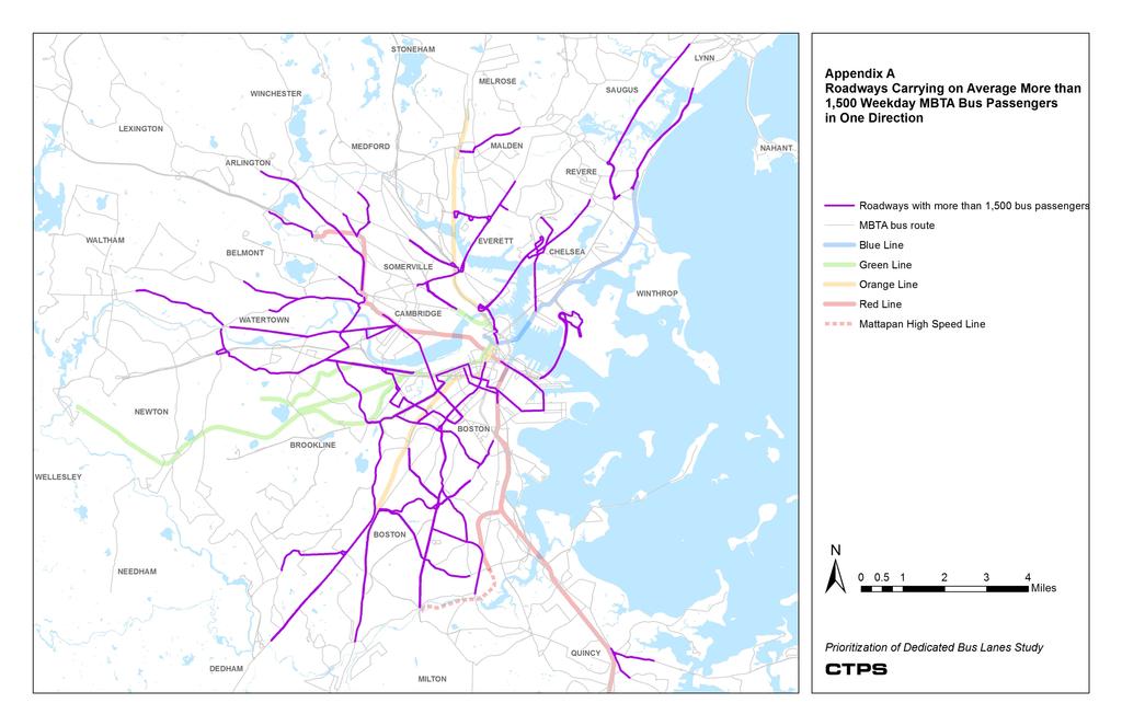
2 locations of roadway segments with comparatively high rates of bus passenger delay, so that they may work with stakeholders to design and implement dedicated bus lanes where appropriate. While this study assesses bus lane warrant based on existing travel conditions, it is not intended to discount the fact that bus lanes may provide further value by their potential to help achieve long-term, transit-supportive planning goals and policies. It is beyond the scope of this project to quantify the impact of bus lanes on automobile users, mode shift, the local economy, transit-oriented development, and other indirect effects that encompass the full scope of bus lane benefits. 2 ASSESSING THE RATE OF WEEKDAY BUS PASSENGER DELAY The Central Transportation Planning Staff (CTPS) to the Region Metropolitan Planning Organization (MPO) used traffic speed data and MBTA bus passenger load data derived from automatic passenger counter (APC) data to assess the average weekday rate of bus passenger delay over roadway segments that carry on average more than 1,500 weekday MBTA bus passengers in one direction. To calculate the rate of bus passenger delay over a specified roadway segment, CTPS multiplied the amount of roadway delay occurring at each point in time a bus trip is scheduled to traverse the roadway segment by the average weekday number of bus passengers who are on board that trip. CTPS aggregated the rate of bus passenger delay for each scheduled weekday trip for all trips over the specified roadway segment to form the total rate of bus passenger delay for an average weekday for that segment. Appendix A shows the network of roadways carrying, on average, more than 1,500 weekday MBTA bus passengers in one direction. To assess the level of roadway delay on each roadway segment, staff used historical traffic speeds from the CTPS INRIX database. CTPS uploaded travel speed data for Tuesdays, Wednesdays, and Thursdays from April 1 April 13, 2012; April 23 May 25, 2012; and September 10 October 26, 2012, for a total of 42 days of data (21 days in the spring and 21 days in the fall). Staff calculated the amount of roadway delay on a roadway segment at each point in time from the difference in observed speed at that time and the baseline speed, where baseline speed is equivalent to either the posted speed limit of the roadway segment or the average speed over the roadway segment between 2:00 AM and 4:00 AM (free-flow speed), whichever is lowest. CTPS chose an approach using historical traffic speeds to assess the amount of roadway delay met by each bus trip because it provides a consistent and objective assessment across the study region. Staff did not use existing bus run-time data to estimate potential running time savings. It is difficult to properly estimate running time for a bus along a Page 2 of 15
3 roadway segment under peak passenger demand and free-flow (bus lane) conditions because existing data for bus running times under free-flow conditions often occurs at times of day when delay from passenger boarding and alighting activity is low and when stops are sometimes bypassed. Figure 1 provides a sample of observed speed, average speed, and baseline speed by time of day for a specified roadway segment. As an example calculation of the rate of roadway delay, using a bus trip occurring at 5:00 PM over the sample roadway segment, the rate of roadway delay is measured as the difference between the observed speed of 18 miles per hour (mph) (3.33 minutes per mile) and the baseline speed of 30 mph (2.00 minutes per mile, circled in Figure 1), which equals 1.33 minutes per mile. Figure 1 Observed Speed, Average Observed Speed, and Baseline Speed for a Sample Roadway Segment 45 5:00 pm Speed (mph) Time of Day Observed Speed Baseline Speed Average Speed Page 3 of 15
4 Figure 2 shows the average weekday passenger load on each scheduled trip by time of day that traverses the sample roadway segment with the continuous level of roadway delay at each point in time calculated from Figure 1. Using the same weekday bus trip scheduled to traverse over the sample roadway segment at 5:00 PM (circled in Figure 2), to determine the average rate of weekday bus passenger delay for that bus trip over the specified roadway segment (48.8 passenger-minutes/mile), one would multiply the average number of weekday passengers on board the bus (41) by the average roadway delay at 5:00 PM (1.19 min/mile). Figure 2 Average Weekday Passenger Load and Roadway Delay for a Sample Roadway Segment :00 pm Bus Passengers Roadway Delay (Min/Mi) Time of Day Bus Passengers Roadway Delay Page 4 of 15
5 The resulting average rate of weekday bus passenger delay for the 5:00 PM bus trip over the specified roadway segment is circled in Figure 3, which shows the average rate of weekday bus passenger delay for each bus trip traversing the sample roadway segment. We aggregated the average rate of weekday bus passenger delay for each bus trip traversing the sample roadway to form the total average rate of weekday bus passenger delay over the roadway segment (6,489 passenger-minutes/mile). Figure 3 Average Rate of Weekday Bus Passenger Delay per Trip over a Sample Roadway Segment Weekday Bus Passenger Delay (Passenger-Min/Mile) :00 pm Time of Day Appendix B shows the rate of weekday bus passenger delay for roadway segments that carry, on average, more than 1,500 weekday MBTA bus passengers in one direction. Page 5 of 15
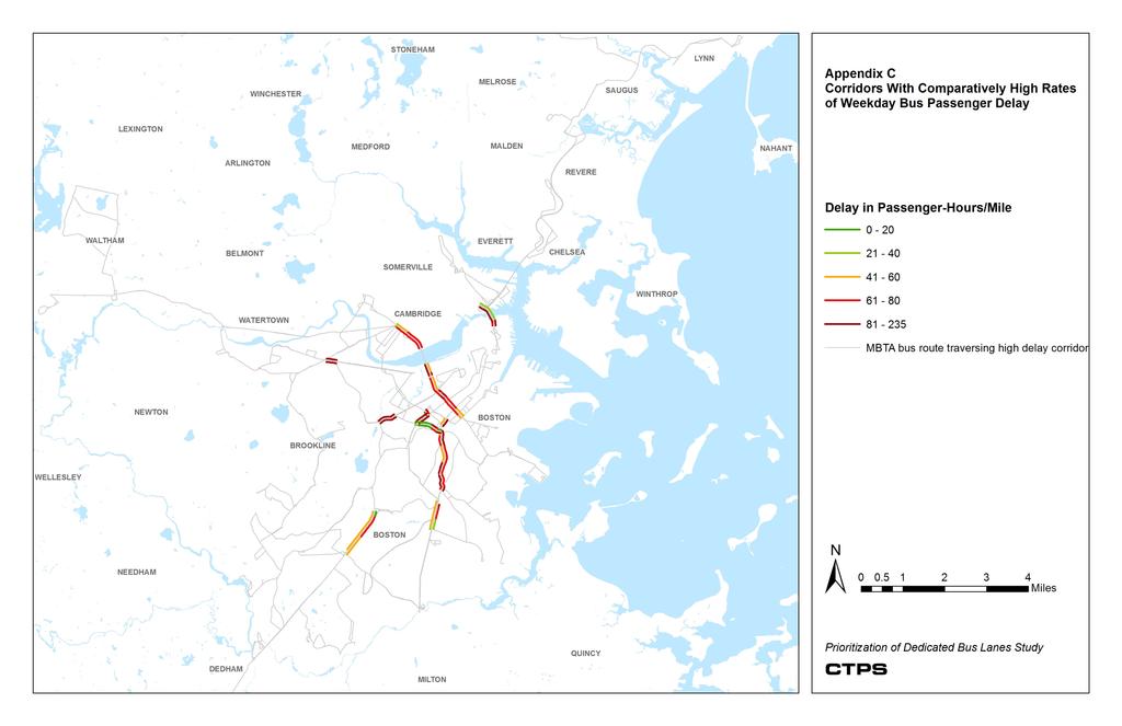
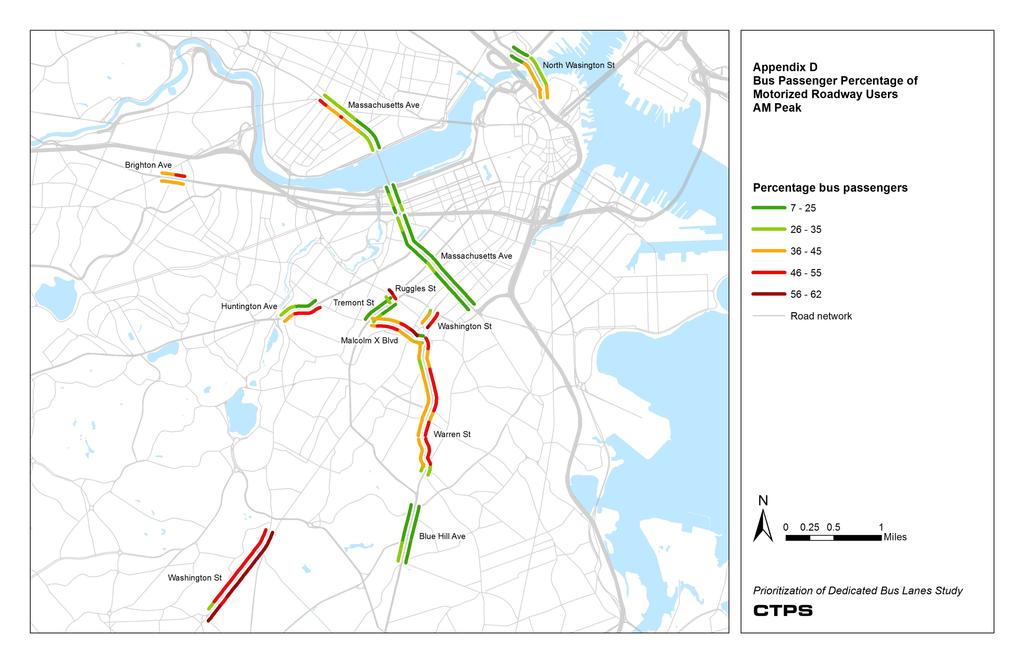
6 3 ROADWAY SEGMENTS WITH COMPARATIVELY HIGH RATES OF WEEKDAY BUS PASSENGER DELAY Once CTPS staff calculated the average weekday rate of bus passenger delay for roadway segments that carry, on average, more than 1,500 weekday MBTA bus passengers in one direction, we assessed the network for corridors that had comparatively high rates of weekday bus passenger delay. Installation of dedicated bus lanes would provide the most effective benefit to bus riders in these corridors. Table 1 and Appendix C show the locations of the identified corridors with comparatively high rates of weekday bus passenger delay. To determine the average rate of weekday bus passenger delay along each corridor, provided in Table 2, we weighted each segment by its length. For intersections located along the identified corridors, CTPS staff obtained peak-hour turning movements from the Transportation Department and the Cambridge Traffic, Parking, and Transportation Department. CTPS used these turning movements to estimate the bus passenger percentage of motorized roadway users along the corridor during the AM peak and PM peak hours of traffic volume, shown in Appendix D and Appendix E. From the turning movements, we derived the number of roadway users along each segment by assuming 1.38 occupants per car and 1 occupant per heavy vehicle. To determine the average bus passenger percentage of motorized roadway users along each corridor, provided in Table 3, we weighted each segment by its length. Page 6 of 15
7 Table 1 Corridors with Comparatively High Rates of Weekday Bus Passenger Delay Corridor City Bus Routes Affected Between North Washington Street at the Route 1 off-ramp and North Washington Street at Valenti Way 92, 93, 111, 426, 428 Partners Shuttles: Charlestown Navy Yard to MGH SRH to North Station Between Massachusetts Avenue at Storrow Drive and Massachusetts Avenue at Albany Street Between Massachusetts Avenue at Western Avenue and Massachusetts Avenue at Memorial Drive Between Washington Street at Warren Street and Washington Street at Melnea Cass Boulevard Between Ruggles Street at Ruggles Station and Dudley Street at Warren Street Between Warren Street at Dudley Street and Blue Hill Avenue at Geneva Avenue Between Blue Hill Avenue at Columbia Road and Blue Hill Avenue at Talbot Avenue Between Washington Street at Forest Hills Station and Washington Street at Cummins Highway Between Huntington Avenue at South Huntington Avenue and Huntington Avenue at Tremont Street Cambridge 1, CT1 MASCO Shuttle: Route M2 - Cambridge to HMS 1, CT1, 64, 70, 70A MASCO Shuttle: Route M2 - Cambridge to HMS 1, 8, 19, 47, SL4, SL5 14, 15, 22, 23, 28, 41, 44, 45, 66 14, 19, 23, 28, 44, 45 14, 22, 28, 29, 45 30, 34, 34E, 35, 36, 37, 40, 50, 51 39, 66 Between Brighton Avenue at Cambridge Street and Brighton Avenue at Harvard Avenue 57, 57A, 66 HMS = Harvard Medical School. MASCO = Medical Academic and Scientific Community Organization. MGH = Massachusetts General Hospital. SRH = Spaulding Rehabilitation Hospital. Page 7 of 15
8 Table 2 Weekday Bus Passenger Delay along Identified Corridors Corridor Between North Washington Street at the Route 1 off-ramp and North Washington Street at Valenti Way Between Massachusetts Avenue at Storrow Drive and Massachusetts Avenue at Albany Street Between Massachusetts Avenue at Western Avenue and Massachusetts Avenue at Memorial Drive Between Washington Street at Warren Street and Washington Street at Melnea Cass Boulevard Between Ruggles Street at Ruggles Station and Dudley Street at Warren Street Between Warren Street at Dudley Street and Blue Hill Avenue at Geneva Avenue Between Blue Hill Avenue at Columbia Road and Blue Hill Avenue at Talbot Avenue Between Washington Street at Forest Hills Station and Washington Street at Cummins Highway Between Huntington Avenue at South Huntington Avenue and Huntington Avenue at Tremont Street Between Brighton Avenue at Cambridge Street and Brighton Avenue at Harvard Avenue Length Average Rate of Weekday Bus Passenger Delay Along the Corridor (Passenger- Hours/Mile) 0.61 mile Northbound: 55.5 Southbound: miles Westbound: 58.6 Eastbound: mile Westbound: 58.5 Eastbound: mile Northbound: Southbound: mile Westbound: 53.1 Eastbound: miles Northbound: 74.7 Southbound: mile Northbound: 60.4 Southbound: miles Northbound: 58.8 Southbound: mile Westbound: Eastbound: mile Westbound: 81.5 Eastbound: 89.4 Cumulative Weekday Bus Passenger Delay Along the Corridor (Passenger-Hours) Northbound: 33.9 Southbound: 60.4 Westbound: Eastbound: Westbound: 46.2 Eastbound: 55.4 Northbound: 21.2 Southbound: 8.9 Westbound: 52.6 Eastbound: 72.9 Northbound: Southbound: Northbound: 35.0 Southbound: 30.1 Northbound: 67.1 Southbound: 56.3 Westbound: 43.3 Eastbound: 67.6 Westbound: 18.7 Eastbound: 20.6 Page 8 of 15
9 Table 3 Average Bus Passenger Percentage of Motorized Roadway Users along Identified Corridors Corridor Between North Washington Street at the Route 1 off-ramp and North Washington Street at Valenti Way Average Bus Passenger Percentage of Motorized Roadway Users Along the Corridor - AM Peak Northbound: 26.8% Southbound: 35.6% Average Bus Passenger Percentage of Motorized Roadway Users Along the Corridor - PM Peak Northbound: 35.8% Southbound: 23.4% Between Massachusetts Avenue at Storrow Drive and Massachusetts Avenue at Albany Street Between Massachusetts Avenue at Western Avenue and Massachusetts Avenue at Memorial Drive Between Washington Street at Warren Street and Washington Street at Melnea Cass Boulevard Between Ruggles Street at Ruggles Station and Dudley Street at Warren Street Westbound: 15.2% Eastbound: 23.0% Westbound: 24.6% Eastbound: 38.7% Northbound: 51.8% Southbound: 36.5% Westbound: 37.1% Eastbound: 34.2% Westbound: 19.2% Eastbound: 15.9% Westbound: 26.8% Eastbound: 33.1% Northbound: 44.0% Southbound: 39.7% Westbound: 22.9% Eastbound: 45.7% Between Warren Street at Dudley Street and Blue Hill Avenue at Geneva Avenue Northbound: 45.9% Southbound: 39.1% Northbound: 32.3% Southbound: 44.7% Between Blue Hill Avenue at Columbia Road and Blue Hill Avenue at Talbot Avenue Northbound: 18.7% Southbound: 18.6% Northbound: 17.1% Southbound: 19.6% Between Washington Street at Forest Hills Station and Washington Street at Cummins Highway Between Huntington Avenue at South Huntington Avenue and Huntington Avenue at Tremont Street Between Brighton Avenue at Cambridge Street and Brighton Avenue at Harvard Avenue Northbound: 58.4% Southbound: 46.1% Westbound: 26.2% Eastbound: 44.7% Westbound: 42.3% Eastbound: 39.6% Northbound: 32.4% Southbound: 59.8% Westbound: 32.7% Eastbound: 29.1% Westbound: 33.0% Eastbound: 29.2% Page 9 of 15
10 4 SUMMARY In this study, CTPS identified segments of Greater roadways where installation of dedicated bus lanes would provide the most effective benefit to bus riders, as measured by the current rate of delay that they encounter. The results of this study will be used to inform city planners and city officials of the location of roadway segments with comparatively high rates of bus passenger delay, so that they may work with stakeholders to design and implement dedicated bus lanes where appropriate. Page 10 of 15
11
12
13
14
15
BOSTON REGION METROPOLITAN PLANNING ORGANIZATION
 PLANNING ORGANIZATIO BOSTON REGION MPO NMETROPOLITAN BOSTON REGION METROPOLITAN PLANNING ORGANIZATION Stephanie Pollack, MassDOT Secretary and CEO and MPO Chair Karl H. Quackenbush, Executive Director,
Better Buses: Getting Boston On Board
 Better Buses: Getting Boston On Board Better Buses: Getting Boston On Board Table of Contents Executive Summary 1 What We Know 4 Policy Recommendations 10 What s Next 14 Acknowledgements 15 www.livablestreets.info
Preliminary Transportation Analysis
 Preliminary Transportation Analysis Goals of a Robust, Multimodal Transportation Network Safe Accessible/Connected Efficient Comfortable Context-Sensitive Motor Vehicle: Continue to analyze the data to
BOSTON REGION METROPOLITAN PLANNING ORGANIZATION
 PLANNING ORGANIZATIO BOSTON REGION MPO NMETROPOLITAN BOSTON REGION METROPOLITAN PLANNING ORGANIZATION Stephanie Pollack, MassDOT Secretary and CEO and MPO Chair Karl H. Quackenbush, Executive Director,
Appendix C. NORTH METRO STATION AREA TRAFFIC IMPACT STATEMENT 88th Avenue Station
 Appendix C NORTH METRO STATION AREA TRAFFIC IMPACT STATEMENT 88th Avenue Station Prepared for: Regional Transportation Department and URS Corporation as part of the North Metro EIS David Evans and Associates,
MEMORANDUM. Charlotte Fleetwood, Transportation Planner
 MEMORANDUM Date: Updated August 22, 2017 To: Organization: Charlotte Fleetwood, Transportation Planner Boston Transportation Department From: Jason DeGray, P.E., PTOE, Regional Director of Engineering
Existing Conditions. Date: April 16 th, Dan Holderness; Coralville City Engineer Scott Larson; Coralville Assistant City Engineer
 Date: April 16 th, 2015 To: From: Re: Dan Holderness; Coralville City Engineer Scott Larson; Coralville Assistant City Engineer Darian Nagle-Gamm, Traffic Engineering Planner Highway 6 (2 nd Street) /
Operational Comparison of Transit Signal Priority Strategies
 Operational Comparison of Transit Signal Priority Strategies Revision Submitted on: November, 0 Author: Adriana Rodriguez, E.I Assistant Engineer Parsons Brinckerhoff 0 South Orange Avenue, Suite 00 Orlando,
BOSTON REGION METROPOLITAN PLANNING ORGANIZATION
 PLANNING ORGANIZATIO BOSTON REGION MPO NMETROPOLITAN BOSTON REGION METROPOLITAN PLANNING ORGANIZATION Stephanie Pollack, MassDOT Secretary and CEO and MPO Chairman Karl H. Quackenbush, Executive Director,
Memorandum. Fund Allocation Fund Programming Policy/Legislation Plan/Study Capital Project Oversight/Delivery Budget/Finance Contract/Agreement Other:
 Memorandum Date: November 20, 2017 To: Transportation Authority Board From: Eric Cordoba Deputy Director Capital Projects Subject: 12/5/17 Board Meeting: San Francisco Freeway Corridor Management Study
Traffic Impact Study. Westlake Elementary School Westlake, Ohio. TMS Engineers, Inc. June 5, 2017
 TMS Engineers, Inc. Traffic Impact Study Westlake Elementary School Westlake, Ohio June 5, 2017 Prepared for: Westlake City Schools - Board of Education 27200 Hilliard Boulevard Westlake, OH 44145 TRAFFIC
Appendix B: Forecasting and Traffic Operations Analysis Framework Document
 Existing Conditions Report - Appendix Appendix B: Forecasting and Traffic Operations Analysis Framework Document This document defines the methodology and assumptions that will be used in the traffic forecasting
TRANSPORTATION ANALYSIS REPORT US Route 6 Huron, Erie County, Ohio
 TRANSPORTATION ANALYSIS REPORT US Route 6 Huron, Erie County, Ohio December 12, 2012 Prepared for: The City of Huron 417 Main Huron, OH 44839 Providing Practical Experience Technical Excellence and Client
MONTGOMERY COUNTY PLANNING DEPARTMENT THE MARYLAND-NATIONAL CAPITAL PARK AND PLANNING COMMISSION
 MONTGOMERY COUNTY PLANNING DEPARTMENT THE MARYLAND-NATIONAL CAPITAL PARK AND PLANNING COMMISSION MCPB Item No. 4 Date: 04-17-14 2014 Mobility Assessment Report José Dory, Senior Planner, Functional Planning
BOSTON REGION METROPOLITAN PLANNING ORGANIZATION
 PLANNING ORGANIZATIO BOSTON REGION MPO NMETROPOLITAN BOSTON REGION METROPOLITAN PLANNING ORGANIZATION Stephanie Pollack, MassDOT Secretary and CEO and MPO Chair Karl H. Quackenbush, Executive Director,
MEMORANDUM. Layout Of Study Intersections And Traffic Control
 BOSTON REGION METROPOLITAN PLANNING ORGANIZATION Richard A. Davey, MassDOT Secretary and CEO and MPO Chairman Karl H. Quackenbush, Executive Director, MPO Staff DATE November 15, 2012 TO FROM RE Town of
Purpose and Need. Chapter Introduction. 2.2 Project Purpose and Need Project Purpose Project Need
 Chapter 2 Purpose and Need 2.1 Introduction The El Camino Real Bus Rapid Transit (BRT) Project (Project) would make transit and other transportation improvements along a 17.6-mile segment of the El Camino
FINAL DESIGN TRAFFIC TECHNICAL MEMORANDUM
 FINAL DESIGN TRAFFIC TECHNICAL MEMORANDUM July 2014 FINAL (SR 43) Project Development and Environment Study From State Road 60 (Adamo Drive) to I-4 (SR 400) Hillsborough County, Florida Work Program Item
List of Exhibits...ii
 One Brickell Traffic Study TABLE OF CONTENTS List of Exhibits...ii EXECUTIVE SUMMARY...1 1. INTRODUCTION...2 1.1 Study Area...2 1.2 Study Objective...5 2. EXISTING TRAFFIC CONDITIONS...6 2.1 Data Collection...6
Appendix 3.2 D. Ridership Errata Sheet
 Appendix 3.2 D Ridership Errata Sheet January 14, 2010 Since the release of the Alternatives Description for the South Coast Rail project, the Massachusetts Department of Transportation has identified
Central Freeway and Octavia Circulation Study
 Central Freeway and Octavia Circulation Study Final Report Plans and Programs Committee San Francisco County Transportation Authority September 18, 2012 Presentation Outline Background and Study Purpose
EXECUTIVE SUMMARY OF CALEDON TRANSPORTATION NEEDS STUDY
 EXECUTIVE SUMMARY OF CALEDON TRANSPORTATION NEEDS STUDY The Caledon Transportation Needs Study has been undertaken as a joint project by the Town of Caledon and the Region of Peel to determine the existing
Roadways. Roadways III.
 Introduction 97 Roadway Design Principles 98 Safe Speeds 99 Optimizing of Street Space 00 Minimum Lane Widths in the City of Boston 02 Design Features that Reduce Operating Speeds 05 Travel Lanes Transit
4. ENVIRONMENTAL IMPACT ANALYSIS 9. TRANSPORTATION AND TRAFFIC
 4. ENVIRONMENTAL IMPACT ANALYSIS 9. TRANSPORTATION AND TRAFFIC 4.9.1 INTRODUCTION The following section addresses the Proposed Project s impact on transportation and traffic based on the Traffic Study
University Hill Transportation Study Technical Memorandum Alternatives Modeling and Analysis May 2007
 Technical Memorandum May 2007 Syracuse Metropolitan Transportation Council Edwards and Kelcey with Wallace Roberts and Todd Alta Planning and Design CONTENTS SECTION ONE- INTRODUCTION...1 SECTION TWO-
TRAFFIC IMPACT ANALYSIS
 TRAFFIC IMPACT ANALYSIS FOR THE CHAMPAIGN UNIT#4 SCHOOL DISTRICT PROPOSED HIGH SCHOOL (SPALDING PARK SITE) IN THE CITY OF CHAMPAIGN Final Report Champaign Urbana Urbanized Area Transportation Study 6/24/2014
Interim Transit Ridership Forecast Results Technical Memorandum
 Interim Transit Ridership 401 South Jackson Street Seattle, WA 98104-2826 September 2012 Table of Contents 1 INTRODUCTION... 1-1 1.1 Project Background... 1-1 2 RIDERSHIP FORECASTS... 2-1 2.1 System Ridership
Having held a public hearing, that Council approve:
 3. MODIFICATIONS TO MERIVALE ROAD FROM FALLOWFIELD ROAD TO OLD HIGHWAY 16 TO ACCOMMODATE THE GROWTH WITHIN THE SOUTH MERIVALE BUSINESS PARK - PUBLIC HEARING COMMITTEE RECOMMENDATIONS Having held a public
METHODOLOGY. Signalized Intersection Average Control Delay (sec/veh)
") Chapter 5 Traffic Analysis 5.1 SUMMARY US /West 6 th Street assumes a unique role in the Lawrence Douglas County transportation system. This principal arterial street currently conveys commuter traffic
Chapter 5 Traffic Analysis 5.1 SUMMARY US /West 6 th Street assumes a unique role in the Lawrence Douglas County transportation system. This principal arterial street currently conveys commuter traffic
Congestion Management Report
 Congestion Management Report F.E. EVERETT TURNPIKE (NORTH), MERRIMACK Segment Length: 7.0 miles Daily Traffic Volumes: 60,000-69,000 Analysis Period: May 2015 Number of Traffic Signals: 0 Number of travel
CITY OF OTTAWA ROADWAY MODIFICATION APPROVAL UNDER DELEGATED AUTHORITY
 RMA-2015-ATM-038 CITY OF OTTAWA ROADWAY MODIFICATION APPROVAL UNDER DELEGATED AUTHORITY DATE: April 22, 2015 SUBJECT Approval of Roadway Modifications Recommended through an Area Traffic Management Study
MEMORANDUM. TO: Transportation Planning and Programming Committee December 4, 2008 of the Boston Region Metropolitan Planning Organization
 MEMORANDUM TO: Transportation Planning and Programming Committee December 4, 2008 of the Boston Region Metropolitan Planning Organization FROM: Mark S. Abbott, PE Efi Pagitsas RE: MBTA Transit Signal Priority
Congestion Management Report
 Congestion Management Report NH 101A (Amherst St and Canal/Bridge St), NASHUA Segment Length: 2.7 miles Daily Traffic Volumes: 9,000-40,000 Analysis Period: August 2015 Number of Traffic Signals: 9 Number
NEWMARKET UPHAM S CORNER
 SOUTH STATION Planning Initiative NEWMARKET UPHAM S CORNER COLUMBIA ROAD (P) FOUR CORNERS/GENEVA Working Advisory Group (WAG) Meeting #5 TALBOT AVENUE MORTON STREET BLUE HILL AVE/CUMMINS HWY (P) RIVER
2.2 TRANSIT VISION 2040 FROM VISION TO ACTION. Emphasize transit priority solutions STRATEGIC DIRECTION
 TRANSIT VISION 2040 FROM VISION TO ACTION TRANSIT VISION 2040 defines a future in which public transit maximizes its contribution to quality of life with benefits that support a vibrant and equitable society,
Date: April 4, Project #: Re: A Street/Binford Street Traffic/Intersection Assessment
 To: Peter Cavanaugh General Electric From: David Bohn, PE Ryan White, PE Date: April 4, 217 Project #: 13421. Re: / Traffic/Intersection Assessment Consistent with the Cooperation Agreement between the
TRAFFIC IMPACT STUDY COMPREHENSIVE UPDATE TOWN OF THOMPSON S STATION, TENNESSEE PREPARED FOR: THE TOWN OF THOMPSON S STATION
 TRAFFIC IMPACT STUDY COMPREHENSIVE UPDATE TOWN OF THOMPSON S STATION, TENNESSEE PREPARED FOR: THE TOWN OF THOMPSON S STATION Transportation Consultants, LLC 1101 17 TH AVENUE SOUTH NASHVILLE, TN 37212
Northbound San Jose Avenue & I-280 Off-Ramp Road Diet Pilot Project
 Project Overview Fed by a two-lane Interstate-280 (I-280) off-ramp, high vehicular volumes and speeds are longstanding issues along San Jose Avenue. Residents in the surrounding neighborhoods have expressed
Project Report. South Kirkwood Road Traffic Study. Meadows Place, TX October 9, 2015
 Meadows Place, TX October 9, 2015 Contents 1 Introduction... 1 2 Data Collection... 1 3 Existing Roadway Network... 2 4 Traffic Volume Development... 2 5 Warrant Analysis... 3 6 Traffic Control Alternative
North Shore Transportation Improvement Strategy
 North Shore Transportation Improvement Strategy Preliminary, Near-term Recommendation 2016 April Transportation Improvement Strategy (TIS) Comprehensive and Analytical A multi-modal transportation strategy
Public Works and Infrastructure Committee. General Manager, Transportation Services
 STAFF REPORT ACTION REQUIRED Extending the Bay Street Bicycle Lanes Date: May 16, 2013 To: From: Public Works and Infrastructure Committee General Manager, Transportation Services Wards: Toronto Centre
Southwest Bus Rapid Transit (SW BRT) Functional Planning Study - Executive Summary January 19 LPT ATTACHMENT 2.
 Functional Planning Study - Executive Summary January 19 LPT ATTACHMENT 2.") Southwest Bus Rapid Transit (SW BRT) Functional Planning Study - Executive Summary 2011 January 19 1 of 19 Introduction This executive summary presents the results of the Southwest Bus Rapid Transit (SW
Southwest Bus Rapid Transit (SW BRT) Functional Planning Study - Executive Summary 2011 January 19 1 of 19 Introduction This executive summary presents the results of the Southwest Bus Rapid Transit (SW
About the Wilmington Downtown Circulation Study
 About the Wilmington Downtown Circulation Study Part of the Wilmington i Initiatives partnership Wilmington Area Planning Council City of Wilmington Delaware Department of Transportation Delaware Transit
APPENDIX F SUPPLEMENTAL TRAFFIC DATA
 APPENDIX F SUPPLEMENTAL TRAFFIC DATA Environmental and Planning Consultants 440 Park Avenue South 7th Floor New York, NY 10016 tel: 212 696-0670 fax: 212 213-3191 www.akrf.com Draft Memorandum To: Michael
EL CAMINO REAL BUS RAPID TRANSIT (BRT) PROJECT
 PROJECT") Agenda Item #4.2 EL CAMINO REAL BUS RAPID TRANSIT (BRT) PROJECT VTA BOARD WORKSHOP MAY 1, 2015 ABOUT THIS PRESENTATION CONTEXT Existing conditions and planning for growth WHAT IS THE PROJECT? Project alternatives
Agenda Item #4.2 EL CAMINO REAL BUS RAPID TRANSIT (BRT) PROJECT VTA BOARD WORKSHOP MAY 1, 2015 ABOUT THIS PRESENTATION CONTEXT Existing conditions and planning for growth WHAT IS THE PROJECT? Project alternatives
Wilshire Boulevard Bus Rapid Transit Project
 Los Angeles County Metropolitan Transportation Authority Wilshire Boulevard Bus Rapid Transit Project COMMUNITY MEETINGS November 2008 Agenda Introduction Proposed Project Overview Participating Agencies
92% COMMUTING IN THE METRO. Congested Roadways Mode Share. Roadway Congestion & Mode Share
 COMMUTING IN THE METRO Roadway Congestion & Mode Share The majority of major roadways in Greater Des Moines are without congestion and have underutilized capacity. This surplus capacity could be used for
OTTAWA TRAIN YARDS PHASE 3 DEVELOPMENT CITY OF OTTAWA TRANSPORTATION IMPACT STUDY. Prepared for:
 OTTAWA TRAIN YARDS PHASE 3 DEVELOPMENT CITY OF OTTAWA TRANSPORTATION IMPACT STUDY Prepared for: The Ottawa Train Yards Inc. 223 Colonnade Road South, Suite 212 Nepean, Ontario K2E 7K3 January 17, 2012
GEARY CORRIDOR BUS RAPID TRANSIT Environmental Analysis. Special Intersections: Preliminary Concepts
 GEARY CORRIDOR BUS RAPID TRANSIT Environmental Analysis Special Intersections: Preliminary Concepts April 2, 2009 FILLMORE: Existing Conditions 3 lanes in underpass, 2 lanes in service road (each direction)
DEPARTMENT OF ENVIRONMENTAL SERVICES. North Harrison Street (Lee Highway to Little Falls Road) Comparative Analysis. Prepared for:
 Comparative Analysis. Prepared for:") DEPARTMENT OF ENVIRONMENTAL SERVICES North Harrison Street (Lee Highway to Little Falls Road) Comparative Analysis Prepared for: Arlington County Department of Environmental Services 2100 Clarendon Boulevard,
DEPARTMENT OF ENVIRONMENTAL SERVICES North Harrison Street (Lee Highway to Little Falls Road) Comparative Analysis Prepared for: Arlington County Department of Environmental Services 2100 Clarendon Boulevard,
Grove Hall Business District Parking Analysis
 Grove Hall Business District Parking Analysis February 2014 Prepared for The Roxbury Great Neighborhoods Partnership Nuestra Comunidad Development Corporation Dudley Square Main Streets Greater Grove Hall
URBAN QUARRY HEADQUARTERS 2717 STEVENAGE DRIVE CITY OF OTTAWA TRANSPORTATION OVERVIEW. Prepared for: Urban Quarry 4123 Belgreen Drive, Ottawa K1G 3N2
 URBAN QUARRY HEADQUARTERS 2717 STEVENAGE DRIVE CITY OF OTTAWA TRANSPORTATION OVERVIEW Prepared for: Urban Quarry 4123 Belgreen Drive, Ottawa K1G 3N2 February 27, 2014 113-584 Overview_1.doc D. J. Halpenny
Spring Lake Park Mounds View North Oaks. Arden Hills. Shoreview. Roseville. Little Canada. Falcon Heights SNELLING. Lilydale. West Saint Paul 35E
 Coon Rapids Blaine Spring Lake Park Mounds View rth Oaks In 2011, Metro Transit embarked on the Arterial 494 Minnetonka Maple Grove Plymouth Hopkins Brooklyn Park New Hope Golden Valley Louis Park Edina
MEMORANDUM. Trip Generation and Distribution. CyRide / ISU Intermodal Facility Steering Committee. Date: August 31, 2009
 MEMORANDUM Transportation Jim Kollbaum, PE 12120 Shamrock Plaza Suite 300 Omaha, NE 68154 (402) 334-8181 (402) 334-1984 (Fax) To: CyRide / ISU Intermodal Facility Steering Committee Date: August 31, 2009
Waterford Lakes Small Area Study
 Waterford Lakes Small Area Study Existing Traffic Conditions PREPARED FOR: ORANGE COUNTY PUBLIC WORKS DEPARTMENT TRAFFIC ENGINEERING DIVISION ORLANDO, FLORIDA PREPARED WITH: INWOOD CONSULTING ENGINEERS
Comparison of Turning Movement Count Data Collection Methods for a Signal Optimization Study. White Paper
 Comparison of Turning Movement Count Data Collection Methods for a Signal Optimization Study White Paper Grand Rapids Southfield Traverse City www.urscorp.com May 2011 Comparison of Turning Movement Count
Baseline Road Rapid Transit: Bayshore Station to Prince of Wales Drive
 Baseline Road Rapid Transit: Bayshore Station to Prince of Wales Drive Planning and Environmental Assessment Study Consultation Group Meetings May 2014 Presentation Agenda Study Overview Study Progress
Bay to Bay Boulevard Complete Streets Project
 Bay to Bay Boulevard Complete Streets Project Dale Mabry Highway to Bayshore Boulevard February 08, 2018 Photo Source: Tampa Bay Times Alessandra Da Pra Meeting Format Introduction Resurfacing Information
In station areas, new pedestrian links can increase network connectivity and provide direct access to stations.
 The Last Mile Planning for Pedestrians Planning around stations will put pedestrians first. Making walking to stations safe and easy is important; walking will be a part of every rapid transit Accessible
UBC Vancouver Transportation Status Report Fall 2014
 UBC Vancouver Transportation Status Report Fall 2014 July 2015 1. Introduction... 1 1.1. Context... 1 1.2. Transportation Monitoring Program... 2 1.3. Changes at UBC Affecting Travel Patterns... 4 1.4.
King Soopers #116 Thornton, Colorado
 Traffic Impact Study King Soopers #116 Thornton, Colorado Prepared for: Galloway & Company, Inc. 1.0 EXECUTIVE SUMMARY King Soopers #116, a grocery marketplace anchored commercial development, is proposed
MoPac South: Impact on Cesar Chavez Street and the Downtown Network
 MoPac South: Impact on Cesar Chavez Street and the Downtown Network Prepared by: The University of Texas at Austin Center for Transportation Research Prepared for: Central Texas Regional Mobility Authority
Community Task Force July 25, 2017
 Community Task Force July 25, 2017 Welcome and Introductions Project Partners Regional Transportation District (RTD) Colorado Department of Transportation (CDOT) Denver Regional Council of Governments
Giles Run Connector Road
 Giles Run Connector Road Laurel Hill Adaptive Reuse Area to Laurel Crest Drive South County Federation Meeting June 14, 2016 History Connector road included in the Laurel Hill Comprehensive Plan amendment
THE LANDMARK AT TALBOT PARK
 TRAFFIC IMPACT STUDY FOR THE LANDMARK AT TALBOT PARK IN NORFOLK, VA INTERMODAL ENGINEERING, P.C. OCTOBER, 200 The Landmark at Talbot Park is a proposed redevelopment of the existing apartments along the
Harrah s Station Square Casino
 Transportation Analysis Harrah s Station Square Casino Pittsburgh, Pennsylvania Submitted To: City of Pittsburgh and Pennsylvania Gaming Control Board Prepared By: DKS Associates GAI Consultants December
SH-6 Corridor Improvement Study Policy Committee Progress Report M O N D AY, J U N E 1 0, B R A Z O S C E N T E R
 SH-6 Corridor Improvement Study Policy Committee Progress Report M O N D AY, J U N E 1 0, 2 0 1 3 B R A Z O S C E N T E R Project Overview Study Goals and Objectives» Improve traffic flow» Reduce delay»
Complete Street Analysis of a Road Diet: Orange Grove Boulevard, Pasadena, CA
 Complete Street Analysis of a Road Diet: Orange Grove Boulevard, Pasadena, CA Aaron Elias, Bill Cisco Abstract As part of evaluating the feasibility of a road diet on Orange Grove Boulevard in Pasadena,
Congestion Evaluation Best Practices
 Congestion Evaluation Best Practices Todd Litman Victoria Transport Policy Institute Presented International Transportation and Economic Development Conference 10 April 2014 Congestion Indicators Indicator
Moving Towards Complete Streets MMLOS Applications
 Moving Towards Complete Streets MMLOS Applications Transportation Education Series May 18 th, 2012 It s not just for cars! Presentation Overview The Complete Streets Movement What is Multi-Modal Level
4.12 TRANSPORTATION Executive Summary. Setting
 4.12 TRANSPORTATION 4.12.1 Executive Summary This section is based on the Multimodal Transportation Impact Study (TIS; 2016) prepared by Omni-Means, Ltd. to evaluate projected transportation impact conditions
CITY OF HAMILTON PLANNING AND ECONOMIC DEVELOPMENT DEPARTMENT Transportation Planning and Parking Division
 CITY OF HAMILTON PLANNING AND ECONOMIC DEVELOPMENT DEPARTMENT Transportation Planning and Parking Division TO: Chair and Members Public Works Committee COMMITTEE DATE: June 18, 2018 SUBJECT/REPORT NO:
MASSACHUSETTS AVENUE BRIDGE REPLACEMENT PROJECT APRIL 25, 2018
 MASSACHUSETTS AVENUE BRIDGE REPLACEMENT PROJECT APRIL 25, 2018 AGENDA Introductions Project Benefits Progress to Date Schedule for Remaining Work Phase 3 Activities, Impacts & Traffic Detours Phase 4 Activities
MEMORANDUM. The primary tasks documented in this memorandum are:
 MEMORANDUM DATE September 29, 2011 TO Transportation Planning and Programming Committee of the Boston Region Metropolitan Planning Organization FROM Mark S. Abbott, P.E. Steven Andrews RE Strategic Visioning
Everett Transit Action Plan. Community Open House November 16, 2015
 Everett Transit Action Plan Community Open House Everett has a great location, but getting around the city and into surrounding communities is a problem for all ages Many Voices, One Future: The Everett
3 ROADWAYS 3.1 CMS ROADWAY NETWORK 3.2 TRAVEL-TIME-BASED PERFORMANCE MEASURES Roadway Travel Time Measures
 ROADWAYS Approximately 6 million trips are made in the Boston metropolitan region every day. The vast majority of these trips (80 to percent, depending on trip type) involve the use of the roadway network
KING STREET TRANSIT PILOT
 STREET TRANSIT PILOT Update toronto.ca/kingstreetpilot #kingstreetpilot HIGHLIGHTS PREVIOUS HIGHLIGHTS TRANSIT RELIABILITY TRANSIT TRAVEL TIMES 85% of streetcars arriving within 4 minutes westbound during
# Southeastern Wisconsin Regional Freeway System Reconstruction Study and Preliminary Recommended Plan
 #70421 Southeastern Wisconsin Regional Freeway System Reconstruction Study and Preliminary Recommended Plan Public Information Meetings and Hearings May June 2002 1 Reason for Freeway System Study 270-mile
BOSTON REGION METROPOLITAN PLANNING ORGANIZATION TECHNICAL MEMORANDUM
 NMETROPOLITAN PLANNING ORGANIZATIO BOSTON REGION MPO BOSTON REGION METROPOLITAN PLANNING ORGANIZATION Stephanie Pollack, MassDOT Secretary and CEO and MPO Chair Karl H. Quackenbush, Executive Director,
Princeton Avenue and Spruce Street Transportation and Site Access Enhancements Project
 Princeton Avenue and Spruce Street Transportation and Site Access Enhancements Project Mercer County Planning Division AECOM Transportation (formerly DMJM Harris) January 29, 2009 Agenda Project Status
Highway 217 Corridor Study. Phase I Overview Report
 Highway 217 Corridor Study Phase I Overview Report November 3, 24 BACKGROUND AND OVERVIEW Study purpose The Highway 217 Corridor Study is developing multi-modal transportation solutions for traffic problems
Key objectives of the survey were to gain a better understanding of:
 3 COMMUNITY INPUT Community input is an essential part of corridor studies. For the SR 87 corridor study, VTA staff conducted an extensive online survey of people living and commuting along the corridor.
U NIVERSITY OF B RITISH C OLUMBIA. Fall 2010 Transportation Status Report
 U NIVERSITY OF B RITISH C OLUMBIA Fall 2010 Transportation Status Report 1 April 2011 U NIVERSITY OF B RITISH C OLUMBIA Fall 2010 Transportation Status Report Contents 1. INTRODUCTION... 1 1.1. Context...
Traffic Impact and Access Study PROPOSED DURKEE FARM ESTATES. Foster Street Littleton, Massachusetts. Prepared for: Grimes Road, LLC.
 Traffic Impact and Access Study PROPOSED DURKEE FARM ESTATES Foster Street Littleton, Massachusetts Prepared for: Grimes Road, LLC. Westford, MA Prepared by: MDM Transportation Consultants, Inc. 28 Lord
BRT for Berkeley A Proposal for Consideration
 BRT for Berkeley A Proposal for Consideration CITY OF BERKELEY STAFF PROPOSAL FOR A LOCALLY PREFERRED ALTERNATIVE OF THE EAST BAY BUS RAPID TRANSIT PROJECT SEPTEMBER 8, 2009 Table of Contents Executive
Congestion Management Report
 Congestion Management Report DANIEL WEBSTER HIGHWAY, MERRIMACK Segment Length: 9.9 miles Daily Traffic Volumes: 13,000-21,000 Analysis Period: July August 2015 Number of Traffic Signals: 14 Number of travel
Public Event 1 Community Workshops
 Public Event 1 Community Workshops Nov. 24 & Dec. 3, 2016 Welcome Workshop Purpose We re looking to you for ideas and insights to help guide future transportation infrastructure planning in the Park Lawn
5858 N COLLEGE, LLC N College Avenue Traffic Impact Study
 5858 N COLLEGE, LLC nue Traffic Impact Study August 22, 2016 Contents Traffic Impact Study Page Preparer Qualifications... 1 Introduction... 2 Existing Roadway Conditions... 5 Existing Traffic Conditions...
LSC TRANSPORTATION CONSULTANTS, INC. 516 North Tejon Street Colorado Springs, CO (719) FAX (719)
 FAX (719)") LSC TRANSPORTATION CONSULTANTS, INC. 516 North Tejon Street Colorado Springs, CO 80903 (719) 633-2868 FAX (719) 633-5430 E-mail: lsc@lsccs.com May 15, 2009 Mr. Davis Farrar Western Slope Consulting, LLC
LSC TRANSPORTATION CONSULTANTS, INC. 516 North Tejon Street Colorado Springs, CO 80903 (719) 633-2868 FAX (719) 633-5430 E-mail: lsc@lsccs.com May 15, 2009 Mr. Davis Farrar Western Slope Consulting, LLC
DIMARCO CANANDAIGUA PROPERTIES HOUSING PROJECT CANANDAIGUA, ONTARIO COUNTY, NEW YORK
 TRAFFIC IMPACT STUDY FOR THE DIMARCO CANANDAIGUA PROPERTIES HOUSING PROJECT CANANDAIGUA, ONTARIO COUNTY, NEW YORK MARCH 14, 2017 PREPARED FOR: 1950 Brighton Henrietta Town Line Rd Rochester, NY 14623 PREPARED
WEDNESDAY, SEPTEMBER 6, :00 PM City Council Chambers, 1 Civic Center Drive, San Marcos, CA 92069
 MINUTES Meeting of the San Marcos Traffic Commission WEDNESDAY, SEPTEMBER 6, 2017 6:00 PM City Council Chambers, 1 Civic Center Drive, San Marcos, CA 92069 CALL TO ORDER: Vice Chairman Rico called the
TRANSPORTATION IMPACT STUDY
 Dundas MEP Developments Inc. City of Toronto 219 and 231 Dundas Street East, Proposed Mixed-Use Development TRANSPORTATION IMPACT STUDY 9782/2 April 216 LEA Consulting Ltd. Consulting Engineers & Planners
AMATS Complete Streets Policy
 AMATS Complete Streets Policy Table of Contents: Section 1. Definition of Complete Streets Section 2. Principles of Complete Streets Section 3. Complete Streets Policy Section 4. Consistency Section 5.
Bus Rapid Transit on Silicon Valley s El Camino Real: Working Together to Create a Grand Boulevard Steven Fisher
 Bus Rapid Transit on Silicon Valley s El Camino Real: Working Together to Create a Grand Boulevard Steven Fisher Senior Transportation Planner Santa Clara Valley Transportation Authority San Jose, CA How
84-88 Columbia Street West Waterloo, Ontario Transportation Impact Study. Paradigm Transportation Solutions Limited
 84-88 Columbia Street West Waterloo, Ontario Transportation Impact Study Paradigm Transportation Solutions Limited June 217 Project Summary Project Number 15255 June 217 Client Masri O Inc. Architects
Chapter 4 Traffic Analysis
 Chapter 4 Traffic Analysis PURPOSE The traffic analysis component of the K-68 Corridor Management Plan incorporates information on the existing transportation network, such as traffic volumes and intersection
FMATS Transportation Improvement Program Project Nomination Form
 FMATS 2015 2018 Transportation Improvement Program Project Nomination Form Project nominations are accepted from the public and are scored based on the adopted Project Scoring Criteria. These criteria
1.0 Purpose and Organization of the Update to the Transit Market Analysis of Freeway-Oriented Express Buses (2008)
") Memorandum To: From: Laura Prickett, Horizon Water and Environment Genevieve Munsey, Environmental Planner, Parsons; Carie Montero, Senior Project Manager and Environmental Practice Lead, Parsons; Date:
Memorandum To: From: Laura Prickett, Horizon Water and Environment Genevieve Munsey, Environmental Planner, Parsons; Carie Montero, Senior Project Manager and Environmental Practice Lead, Parsons; Date:
BOSTON REGION METROPOLITAN PLANNING ORGANIZATION MEMORANDUM. DATE June 2, 2011
 BOSTON METROPOLITAN PLANNING ORGANIZATION State Transportation Building Ten Park Plaza, Suite 2150 Boston, MA 02116-3968 Tel. (617) 973-7100 Fax (617) 973-8855 TTY (617) 973-7089 www.bostonmpo.org Jeffrey
Bridge Street Corridor Study Report
 Bridge Street Corridor Study Report Prepared for: Prepared by: BRIDGE STREET CORRIDOR STUDY REPORT PREPARED FOR: CITY OF ARROYO GRANDE COMMUNITY DEVELOPMENT DEPARTMENT 300 EAST BRANCH STREET ARROYO GRANDE,