This report has been prepared for Whitmore Parish Council and Baldwins Gate Action Group by Mr Graham Wheildon, I.Eng., AMICE.
|
|
|
- Anissa Mills
- 5 years ago
- Views:
Transcription
1
2 Whitmore Parish Council and Baldwins Gate Action Group Page 1 About the author This report has been prepared for Whitmore Parish Council and Baldwins Gate Action Group by Mr Graham Wheildon, I.Eng., AMICE. In over 40 years of civil engineering Mr Wheildon has held highways development control posts at Scarborough Borough Council and Derbyshire County Council. He was seconded to work in the Development Control Birmingham office of the Highways Agency. In the course of his career Mr Wheildon has supervised many new developments and highway improvements. During his time at Scarborough he also dealt with drainage adoptions and land drainage. Cllr Wheildon is a member of Whitmore Parish Council and is the Parish Council s Community Speedwatch Coordinator.
3 Whitmore Parish Council and Baldwins Gate Action Group Page 2 Introduction The purpose of this report is to set out the technical case for dismissal of the appeal on highway safety and access grounds. Although the application was refused on grounds of highway safety and access, the comments of Staffordshire County Council Highways (SCC) prior to the decision did not support refusal. SCC s comments and negotiations with the developer were flawed, being weak on a technical basis, and fell short in not recommending refusal of the application. Highway safety and access issues were raised by Whitmore Parish Council, Baldwins Gate Action Group and residents of Baldwins Gate throughout the application process, and the site visit by the Planning Committee contributed significantly to the decision to refuse the application. This report deals with the following: 1 The A53 in national, regional and local context 2 Appellant s proposed access to the development via Gateway Avenue 3 Access onto the A53, including sightlines for the development access 4 Traffic data, Traffic Impact Assessment and RSA1 5 Mitigation measures and proposals 6 Flood risk Construction access is dealt with separately from this report. 1 The A53 in national, regional and local context 1.1 National The A53 is a classified road with primary route (green) signs and primary destinations. It links the A500/M6 to Chester and Shrewsbury. Via the A50 and A500 it links the M1 from Derby and the East coast ports to the Mid-Wales and West coast ports. Among the 12,000 vehicles a day that pass through Baldwins Gate are a large proportion of HGVs and commercial traffic. Most of the vehicles pass through during business hours. Traffic data shows that vehicle speeds increase significantly after business hours. (See attached SCC data for the period 26 September 3 October 2013)). 1.2 Regional At the western end of Baldwin s Gate, Woodside and Sandy Lane (leading off Woodside) link the A53 to the A51. One mile to the east of Baldwins Gate, Bent Lane provides another link between the A53 and A51. The A53 and A51 cross one mile to the west of Baldwins Gate, at Blackbrook. The A51 is

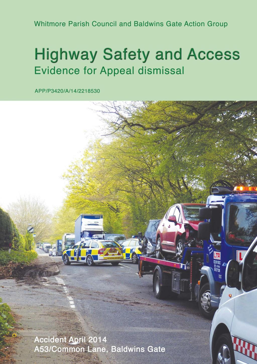
4 Whitmore Parish Council and Baldwins Gate Action Group Page 3 another primary route and links Crewe and Nantwich to Stone and Stafford, Stone being a hub for new business and Stafford being the county seat. Both roads serve large populations. The majority of private motorists are commuters who travel along these two roads at or in excess of the speed limit. The majority of traffic on the two roads travels through Baldwins Gate. Although most drivers repeat the journey daily, there are also a large number of one-time journeys. 1.3 Local The A53 through Baldwins Gate is a village road serving two shops/post office, a filling station/shop, a pub, a farm and a church. On the south side a loop road provides access to the school and the doctor s surgery (Map 1). The A53 bisects the community of Baldwins Gate. In such cases, the presence of a classified road has an inordinate effect on the community. Accidents that close the A53 have a large impact on the local area and on commuter traffic (Figure 1). With the exception of the pub, all facilities and services in the village are located on the south side of the A53. Because of the perceived danger of the road residents of the development would be likely to use their cars to access the village s facilities and services, including the school. Figure 1 Road accident at eastern entrance to Baldwins Gate, 29 April 2014

5 Whitmore Parish Council and Baldwins Gate Action Group Page 4 The A53 is also a bus route. Baldwins Gate has four bus stops, two on each side of the road. Buses travel from Shrewsbury to Hanley via Newcastle on a single route, at a rate of 1 per hour in each direction, such that passengers would have to change in Newcastle if they wanted to access the main doctor s surgery in the neighbouring village of Madeley a journey of approximately 11 miles to travel 4 miles along the interconnecting roads. (Map 2) Highway conditions and traffic Over the years housing development in the village along the A53 has led to road improvements to provide footways within the available curtilage, and the street lighting has changed from footpath standard to highway standard albeit rural highway standard in parts and better to meet a section 278 scheme. The lighting has been installed over a number of years and, as such, varies in standard and type. At only 6.2m wide, the A53 through Baldwins Gate is below the standard for a busy classified road. Such a road should be 7.3m wide, with widening on bends. There should be turning refuges for the many junctions, with islands marked by illuminated bollards. There should be wide verges, and footways set back to protect pedestrians from having to walk alongside the many HGVs travelling through the village (Figure 2). Footways are as little as 1.7m wide and the available width is sometimes reduced by poles, posts and overgrown hedges. All this is clearly visible on site. Figure 2 HGV passing pedestrians near the end of Gateway Avenue

6 Whitmore Parish Council and Baldwins Gate Action Group Page 5 Within the area defined by the village envelope there are 11 road junctions. A short distance to the west is the junction with Woodside, which is a bus route and a route onto the A51 for residents of Baldwins Gate, Madeley Park Wood and Madeley village. None of these junctions, with the exception of Gateway Avenue, has been assessed Business and residential accesses Within the area defined by the village envelope there are accesses and/or parking on the A53 for two shops/post office and a hairdresser s; a pub; a filling station/shop forecourt; a workshop; and to railway maintenance yard. There are also several farms in the immediate vicinity. Within the village envelope there are also 38 domestic accesses onto the A53 serving 42 dwellings. At some of the older residences and where residences are situated on backlands one access serves more than one property (Figure 3). Of the 42 dwellings served by vehicle accesses onto the A53, not all have turning facilities enabling vehicles to enter and leave in forward gear. Turning facilities are not mandatory for these properties and where they do exist householders have often put them in for safety reasons. Figure 3 Shared domestic access onto the A53 in Baldwins Gate Future traffic The appellant s A53 traffic data does not demonstrate the growth in volume that has taken place over recent years due to development along the A53 and the nearby A51. These two roads complement each other for distance commuting and business traffic. Large developments at
7 Whitmore Parish Council and Baldwins Gate Action Group Page 6 Loggerheads and Market Drayton have increased the traffic through the village and will continue to do so, as has the completion of the A50. Business growth in Stone has likewise influenced the traffic growth. Further, data projections for future traffic based on national standards cannot take account of local vagaries such as school issues, shopping trends and business development such the Müller dairy in Market Drayton, which is situated on the A53 10 miles south-west of Baldwins Gate and is serviced by many HGVs daily via Baldwins Gate. Taking into account current and planned development along the A53/A51, the local traffic will be in excess of the national road freight statistics (NRFS) used by the appellant. (NRFS are published by the DfT.) 2 Appellant s proposed access to development via Gateway Avenue 2.1 Inappropriate design criteria With the SCC s approval, the appellant has applied the design guidance in Manual for Streets 2, which replaced previous guidance, including DB32. Manual for Streets 2 made changes to the design of residential streets and introduced narrow carriageways, tight bends and poor visibility so as to improve road safety by making residents drive more slowly. However, such guidance is limited to housing estates, where, by design, speeds are lower. The Manual for Streets 2 guidance recognises that there are limitations to this, and recommends a return to the DB32 guidance in cases where speeds are higher (p. 90, para. 7.5). There is a clear difference between a junction onto a residential street and the Gateway Avenue junction with the A53 in Baldwins Gate. If there were a requirement for section 278 highway improvement works in Baldwins Gate, then the SCC engineers would use the Design Manual for Roads and Bridges and the appropriate TA and TD design guides. Through traffic on a main road does not drive as responsibly as local housing traffic. It is inappropriate to apply housing road criteria to the A53 in Baldwins Gate. 2.2 Flawed junction design While the appellant s Picady design demonstrates the junction working, it is in fact flawed. Picady is a junction design software. It uses hourly traffic flows as if the traffic flowed uniformly. Because of the uneven traffic flows and the many convoys through Baldwins Gate (see 2.2.1) it cannot produce an accurate model of the A53/Gateway Avenue junction. Because slow-moving

8 Whitmore Parish Council and Baldwins Gate Action Group Page 7 vehicles cause the traffic to bunch up, a vehicle turning right into Gateway Avenue will cause significant tailbacks Convoys formed by local bottlenecks The important information is the number of gaps between vehicles over the peak period, but this information is not accurate because it is not possible to model the traffic passing through several local bottlenecks on the approach to Baldwins Gate. This is typical of a model for traffic flows through a village. What happens is that vehicles catch up behind slower-moving vehicles and form queues or convoys (Figure 4). Figure 4 Vehicle convoys travelling through Baldwins Gate Westbound from Newcastle on the A53 there are a roundabout and two speed restrictions in isolation, with a junction at Three Mile Lane. Eastbound, at the junction with the A51 two streams of traffic merge and there are bends and a speed reduction coming into Baldwins Gate. The resulting convoys through the village can be 20 vehicles long in both directions. The engineering model should be analysed taking this into account. If the highway land were available the solution might be to put in a double right-turn harbourage at Tollgate Avenue/Gateway Avenue. But there is no highway land available. 2.3 Geometry of Gateway Avenue Gateway Avenue is 4.8m wide, which is narrower than the standard required for a new development (5.5m). The appellant insists that SCC has advised that even though Gateway Avenue is narrower than the standard required for new development, it is satisfactory for the access. The difference is that the wider standard permits two commercial vehicles to pass.
9 Whitmore Parish Council and Baldwins Gate Action Group Page 8 The total length of Gateway Avenue is 80m, and it is likely that passing of commercial vehicles could happen, given the general continuing growth in commercial deliveries to private residences. Without a wider road or passing places, development should not take place. The residents of Gateway Avenue should not be disadvantaged in comparison to new house occupiers living on streets designed to SCC s new development design guide. 2.4 Unsuitable layout of Gateway Avenue Although the layout of Gateway Avenue looks as if it can be extended, the road was effectively removed as a potential development access by the drafting of the village envelope, which excludes land beyond the developed area. This may have been done in recognition that the road and the access are not suitable. The nonsuitability of the road as a development access can be seen from the finished geometry of the road and the not-completed visibility splays at the junction. New developments off the A53 since the building of Gateway Avenue and the other 1960s estates have required normal junction access works and have been built to a higher standard than Gateway Avenue, as more land was available. Thus, the newer developments (Fair-Green Road and Lakeside) have at least the minimum sightline and junction geometry. 3 Access onto the A53, including sightlines, for the development access The access onto a classified road from a road serving 150 houses should be 4.5m x 90m (30mph). Guidance on the criteria is a national standard and is based on stopping distance and reaction times for drivers exiting a road into moving traffic. If speeds are in excess of 30mph, then actual speeds should be used. All surveys carried out recently in Baldwins Gate show average speeds above the speed limit (e.g. see attached SCC traffic data). This could increase the sightline requirement to 4.5m x 120m.The sightlines achievable at Gateway Avenue are approximately 2m x 50m. Given that vehicle speeds are in excess of 30mph (85%ile is 34mph), this means that the current available visibility is well below an acceptable standard. This would be made worse by additional traffic from more houses. Accidents are the result of convoy traffic and poor junction visibility. Drivers crash into the rear of a car that has just pulled out, or into a car that has just braked hard to avoid a braking car. The appellant s calculation for sightlines from a residential road onto a collector road is flawed because the A53 is a primary route, not a local distributor road. In using the formula in Manual for Streets 2, the appellant has arrived at a sightline which is based on vehicle stopping speeds and reaction times. The Manual for Streets 2 discusses the time required for an emergency stop, which
10 Whitmore Parish Council and Baldwins Gate Action Group Page 9 has improved in recent times. This may work within a residential envelope, but for vehicles exiting from Gateway Avenue and entering the flow of traffic on the A53, to cause an emergency stop by an oncoming vehicle would be a recipe for more accidents (rear-end shunts and collisions due to swerving). From the other accesses onto the A53 from the other side roads it is also necessary to merge into traffic, and this is best achieved by having good junction visibility. The sightlines could be improved, but this would require third-party land. The junction radii would have to be improved for vehicles turning into and out of the classified road. A minimum of 6m radii are required. This would affect the existing road geometry. For design purposes a road such as the A53 is stated in DMRB part 3 TA79/99 as a UAP4 30mph 7.3m wide + carriageway with 15% 25% HGVs. The A53 is clearly below this standard. Therefore a departure from standards would be involved and approval by the highway officer would be required. These issues should not be left to a detailed design stage, as they are not achievable. The appellant s analysis of the junction using TA42/95 is at best a distraction and at worst an attempt to blindside the issues on the A53. The traffic generated by the development would be travelling via an already substandard junction onto a classified road with major traffic issues during the working day. There are clearly road safety issues that would be made worse by a poor development access. This should be recognised and the refusal upheld. 4 Traffic data, Traffic Impact Assessment and RSA1 4.1 Traffic data The measured traffic data is not in dispute. The Community Speed Watch records vehicle numbers up to 1,200 an hour at peak times. Vehicle speeds which are recorded at 32mph (85%ile) are not disputed. (This is above the speed limit and should be the figure used for the calculation of sightlines, as per DfT standards.) However, the spread of speeds is worrying and has not been addressed. There are a large number of vehicles travelling in excess of 40mph. The SSID data in the appellant s TIA shows an 85%ile of 32 mph. SCC data indicates 34 mph with the 95%ile at 46mph. Vehicle speeds are the matter that is of most concern to the residents of Baldwins Gate. If you are trying to get your vehicle onto the road from a drive or a road junction, then speed is of concern. The consultant s data, the SCC data, the Community Speedwatch data and the Speed Indicator Device data reveal speeds in excess of the signed limit. DMRB Part 3 TA85/01 gives guidance on
11 Whitmore Parish Council and Baldwins Gate Action Group Page 10 improving roads such as the A53. This should have been referred to by SCC in its original planning response. 4.2 Traffic Impact Assessment (TIA) The TIA, as expected, contains the minimum data for an access onto the A53. However, there are numerous other active junctions in the near vicinity of Gateway Avenue which impact on the safety of the proposal. Drivers experience the issues of exiting from these roads on a daily basis. Gateway estate has 33 dwellings; Sandyfields 28; Appleton Drive 47; Fair-Green Road 46; Meadowfields estate and Tollgate Avenue 44; Lakeside 48. Meadow Way and Tollgate Avenue form a loop road that serves as a circular route to access the school (including for school buses) and the doctor s surgery. The additional turning manoeuvres at peak times should have been accounted for in the TIA, but they were not. It would be valuable data if the whole village, or at least the two junctions close to Gateway Avenue (Tollgate Avenue and Meadow Way), were also modelled. 4.3 RSA1 Stage 1 Safety Audits have a limited scope and only look at the proposals. The most appropriate survey would have been a Safety Assessment. This could have looked at existing pedestrian, vehicle and road issues at the Gateway Avenue junction and along the A53: the impact of passing vehicles on pedestrians on the existing footways on the A53; the difficulties in crossing the road; the impact of speeding vehicles and the sheer number of vehicles travelling along a road with bends; the existing Gateway Avenue junction and its shortcomings; the speed reductions and lighting necessary to ensure the A53 is a safer road; the fact that the number of road traffic accidents in the last 12 months indicates an increase in average speeds. 5 Mitigation measures and proposals 5.1 Mini roundabout The appellant, in consultation with SCC, adopted a do nothing approach at the Gateway Avenue/A53 junction. In reaction to the local response to this, the appellant then suggested installing a roundabout, which was supported by SCC. It was demonstrated that this would not be workable both within the existing

12 Whitmore Parish Council and Baldwins Gate Action Group Page 11 highway and on account of adjacent private accesses. The third proposal was then to leave the junction as existing but provide a Puffin crossing. 5.2 Puffin crossing with call loop A second controlled crossing in Baldwins Gate would be useful, but national guidance requires them to be situated away from junctions and accesses. SCC has stipulated that the proposed Puffin crossing should have a call loop serving traffic on Gateway Avenue. There are few examples of such a controlled crossing, and they fall outside the design guidelines. The purpose of a controlled crossing is to enable pedestrians to cross the road, not to act as junction signalling. If the crossing were to go to all red without a pedestrian, then this would look like a fault and encourage drive-throughs. The Puffin signal is different to a Pelican, and if there is a Pelican nearby on the same road this can cause confusion for both drivers and pedestrians. The footway on the north side of the A53 at the site of the proposed crossing is only 1.7m wide. This is below the recommended 2.0m and does not allow pedestrians with pushchairs to safely pass pedestrians waiting to cross the road. Traffic signal posts would worsen the situation. There are private accesses in the area of the proposed Puffin crossing. For this reason and because of the limited footway width, pedestrian guard rails could not be installed (Figure 5). Householders would not be able stop on the road (Highway Code, section 215). If a driver needed to stop, open a Figure 5 Traffic accident at the site of proposed Puffin crossing, 30 May 2014
13 Whitmore Parish Council and Baldwins Gate Action Group Page 12 gate or wait for traffic to pass before reversing in, then they would be breaking the law and could be prosecuted. There are examples of such controlled crossings being installed, only to be abandoned and not put into use, as they failed to work, due to legal objections from householders. A pedestrian crossing cannot be used as a speed or junction control device, or for traffic calming. It cannot be used to mitigate inadequate sight lines. 6 Flood risk The highway authority has required an adoptable road layout that is drained to a suitable outfall. The existing roads are served by a county council highway drainage system that is connected to a pumping station in Meadow Way. This pumping station might require upgrading, as there are records of flooding in Meadow Way in recent years. If the A53 were to be flooded, this would be a serious event. 7 Conclusion The proper response from SCC would have been to recommend refusal of the access via Gateway Avenue without improvements to the geometry. The DMRB gives advice on mini roundabouts and improvements to existing roads. Attachments Map 1 Baldwins Gate Map 2 Route from Baldwins Gate to Madeley SCC Speed Statistics Summary and Length Summary, 26 September 3 October 2013 Documents referred to The Manual for Streets 2 (2010) Design Manual for Roads and Bridges

14 Whitmore Parish Council and Baldwins Gate Action Group Page 13 Map 1 Baldwins Gate, facilities and services (Google mapping and imagery)
")
15 Whitmore Parish Council and Baldwins Gate Action Group Page 14 Map 2 Bus and car routes from Baldwins Gate to main doctor s surgery in Madeley (OS mapping from GetMapping.com)
16 Whitmore Parish Council and Baldwins Gate Action Group Page 15
17 Whitmore Parish Council and Baldwins Gate Action Group Page 16
Audit No. RSA Stage 1 Road Safety Audit Bermuda Park, Nuneaton Getting West Nuneaton Moving: Bermuda Connection
 Audit No. RSA 2199 Stage 1 Road Safety Audit Bermuda Park, Nuneaton Getting West Nuneaton Moving: Bermuda Connection 1 1.0 INTRODUCTION 1.1 This report results from a Stage 1 Road Safety Audit for a highways
Appendix A Type of Traffic Calming Measures Engineering Solutions
 Appendix A Type of Traffic Calming Measures Engineering Solutions PHYSICAL MEASURES Central Hatching The major consideration of this feature is that, these markings can only be laid down the centre of
Rhebogue Neighbourhood Greenway. Road Safety Audit Stage 2
 Rhebogue Neighbourhood Greenway Road Safety Audit Stage 2 Report Number: 12/007/00/00057 July 2014 Mid West National Road Design Office Lissanalta House, Dooradoyle County Limerick Tel: 061 496 800 Fax:
Speed Limit Policy Isle of Wight Council
 APPENDIX B Speed Limit Policy Isle of Wight Council 2009 Contents Section 1 Introduction 1.1 Links with the Local Transport Plan Section 2 Speed Limits on Urban Roads and Residential Areas 2.1 20mph Limits
CHECKLIST 2: PRELIMINARY DESIGN STAGE AUDIT
 CHECKLIST 2: PRELIMINARY DESIGN STAGE AUDIT 2.1 General topics 2.1.1 Changes since previous audit Do the conditions for which the scheme was originally designed still apply? (for example, no changes to
Kings Road, Herne Bay: Proposed Crash Remedial Measure
 Kings Road, Herne Bay: Proposed Crash Remedial Measure To: Canterbury Joint Transportation Board 17 February 2015 By: Classification: Ward: Tim Read - Head of Transportation Unrestricted Herne Bay Summary:
BLYTHEWOOD PARK, BROMLEY
 BLYTHEWOOD PARK, BROMLEY Proposed Access Junction to Serve a Single Residential Dwelling On behalf of Robert Pooke CONTENTS Introduction...1 Appeal Site and Planning History...2 Relevant Transport Policy...4
Swamp Road Residents Study
 Swamp Road Residents Study SRRG Meeting with PennDot and Elected Officials Newtown and Wrightstown, PA April 25, 2008 Newtown Township Section of Swamp Road Limited Public Funds No reconstruction of a
LEA BRIDGE ROAD - A STREET FOR EVERYONE Public consultation document
 LEA BRIDGE ROAD - A STREET FOR EVERYONE Public consultation document TELL US Bakers Arms to Leyton Green Road (Section D, E, F) Leyton Green Road to Whipps Cross Roundabout (Section G) YOUR VIEWS www.enjoywalthamforest.co.uk
MILTON ROAD LLF PROJECT UPDATE
 Greater Cambridge City Deal MILTON ROAD LLF PROJECT UPDATE 9 th May 2017 Project objectives Comprehensive priority for buses in both directions wherever practicable; Additional capacity for sustainable
Local Highway Panels Members Guide. 5 Crossing Facilities
 Local Highway Panels Members Guide 5 2 Local Highway Panels (LHP) Members Guide 2016/17 1. Introduction On the Network where there are sufficient crossing opportunities most individuals are able to cross
ADOPTED BISHOPS LYDEARD & COTHELSTONE PARISH COUNCIL
 ADOPTED BISHOPS LYDEARD & COTHELSTONE PARISH COUNCIL Clerk to the Council: Mrs M Rousseau, West View, West Bagborough, TA4 3EG Phone: 01823 432 658 Email: clerk@bishopslydeard.org http://www.bishopslydeard.org.uk/
Appendix F CAPITA Technical Audit
 Appendix F CAPITA Technical Audit West Hendon - Major Review of Technical Audit Responses 14 June 2016 Quality Management Quality Management Job No Project Location Title CS/086106 West Hendon - Major
DESIGN CODE. Enterprise West Harlow London Road North Design Code 21
 DESIGN CODE Enterprise West Essex @ Harlow London Road North Design Code 21 4 MAXIMUM BUILDING HEIGHTS 4.1 Table 4A sets out maximum building height standards for each character area within the LDO boundary.
Sevenways Roundabout, and the need for a Road Safety Scheme:
 Sevenways Roundabout, and the need for a Road Safety Scheme: The way the current roundabout has evolved has obviously created an environment that is dangerous for all road users, motorists, cyclists and
Collision Site Investigation - Bodenham By-Pass Background
 Collision Site Investigation - Bodenham By-Pass Background The junction of the C12 and A338 was the subject of a Local Safety Scheme (LSS) in 2011. Analysation of the collisions at the time revealed the
IMPROVEMENT OPTIONS REPORT - WONERSH VILLAGE. for WONERSH PARISH COUNCIL. March V3.0 stilwell-ltd.co.uk
 IMPROVEMENT OPTIONS REPORT - WONERSH VILLAGE for WONERSH PARISH COUNCIL March 2016 V3.0 stilwell-ltd.co.uk Improvement Options Report Wonersh Village, Wonersh Date of Prepared Checked Revision Comments
Phone: Ref No: 06/2018/0884
 Development Directorate Preston City Council Town Hall Lancaster Road Preston PR1 2RL FAO Ben Sandover Phone: 01772 533855 Email: david.allen@lancashire.gov.uk Ref No: 06/2018/0884 Date: 20 September 2018
SLOUGH Stage 3 Road Safety Audit of A4 London Road, M4 J5 to Sutton Lane
 SLOUGH Stage 3 Road Safety Audit of A4 London Road, M4 J5 to Sutton Lane Exception Report Client Officer Rudo Beremauro Date 20 January 2015 RSA /Project Sponsor s Contents Section 3 Project Sponsor's
Background. Caversham a vision for the future. Joint public meeting arranged by:
 Joint public meeting arranged by: Sharing our Streets Caversham a vision for the future and Caversham Traders Association This presentation followed a presentation by Simon Beasley, Network Manager for
AD L T r a f f i c a n d H i g h w a y s E n g i n e e r i n g L t d BRIEFING NOTE B4219 COWLEIGH ROAD, STORRIDGE (ADL REF: 3409/09 NOVEMBER 2017)
") AD L T r a f f i c a n d H i g h w a y s E n g i n e e r i n g L t d ADL House, Oaklands Business Park, Armstrong Way, Yate, Bristol, BS37 5NA Tel: 01454 332 100 Fax: 01454 327 983 Email: cad@adltraffic.co.uk
AD L T r a f f i c a n d H i g h w a y s E n g i n e e r i n g L t d ADL House, Oaklands Business Park, Armstrong Way, Yate, Bristol, BS37 5NA Tel: 01454 332 100 Fax: 01454 327 983 Email: cad@adltraffic.co.uk
Perne Rd / Radegund Rd Roundabout Cambridge
 Perne Rd / Radegund Rd Roundabout Cambridge The conversion of an conventional urban roundabout to continental geometry A little bit of history The first traffic roundabout was built in Sollershott, Letchworth
Process for managing parking on verges, footways and footpaths
 Process for managing parking on verges, footways and footpaths Author: MG/NR Highways and Transport Environment Department Date: 28 July 2015 Version: 2.0 PARKING ON VERGES, FOOTWAYS AND FOOTPATHS Introduction
Chicane Schemes. Traffic Advisory Leaflet 12/97 December Introduction
 Traffic Advisory Leaflet 12/97 December 1997 Chicane Schemes Introduction Traffic Advisory Leaflet 9/94 "Horizontal Deflections" reported on the results of track trials carried out by the Transport Research
IAN WHITE ASSOCIATES. Crawley Station Gateway Public Realm
 IAN WHITE ASSOCIATES Crawley Station Gateway Public Realm contents 1. objectives & client brief 2. site appraisal 3. best practice guidance 4. design concept 1. objectives & client brief Crawley Train
1.5 On this basis it is fundamental that the Transport Strategy for the site focuses on the following key criteria,
 1.0 Introduction 1.1 The Transport Assessment has been prepared on behalf of Eon and Roger Bullivant Ltd in respect of the proposed mixed use sustainable urban extension of Drakelow Park. 1.2 The methodology
MARKHOUSE ROAD IMPROVEMENTS
 MARKHOUSE ROAD IMPROVEMENTS www.enjoywalthamforest.co.uk Waltham Forest is changing and we want you to be part of it. Thanks to a funding pot of 27million from Transport for London, we re delivering the
Southside Road. Prepared for: City of St. John s Police & Traffic Committee. Prepared by: City of St. John s Traffic Division
 Southside Road Prepared for: City of St. John s Police & Traffic Committee Prepared by: City of St. John s Traffic Division January 2007 Southside Road - Traffic Report Page 1 of 9 BACKGROUND: th At the
Frascati Road and Temple Hill Route Improvements. Outline Design Report to Accompany Public consultation
 Frascati Road and Temple Hill Route Improvements Outline Design Report to Accompany Public consultation September 2013 Background: Dún Laoghaire-Rathdown is committed to providing high quality pedestrian
A guide to how local communities can change local speed limits
 A guide to how local communities can change local speed limits The Council s approach to speed management Speeding continues to be one of the key road safety concerns being raised by local communities.
Offaly Local Authorities Traffic Calming Policy April 2016
 Offaly Local Authorities Traffic Calming Policy April 2016 Charlie McCarthy, Senior Engineer, Roads and Infrastructure, Offaly County Council, Aras An Chontae, Charleville Road, Tullamore, Co. Offaly.
Appendix D Stage 1 Road Safety Audit
 N2 Monaghan Town to Emyvale Road Improvements Part 8 Application Description of Proposed Development Appendi D N2 Monaghan Town to Emyvale, County Monaghan Proposed Pavement and Minor Improvement Scheme
Report to Cabinet. 18 May 2016
 Agenda Item 8 Report to Cabinet 18 May 2016 Subject: Presenting Cabinet Member: Proposed CCTV Enforcement of Traffic Contraventions in a Bus Lane (Key Decision Ref. No. HE030) Highways and Environment
SHOTLEY BRIDGE VILLAGE TRUST
 SHOTLEY BRIDGE VILLAGE TRUST Traffic & Parking Study - 2009 The Parking Lot, a focus group of the Shotley Bridge Village Trust, has undertaken this study. Evidence was gathered, through surveys during
APPELLANT S STATEMENT OF CASE
 TOWN & COUNTRY PLANNING ACT 1990 (AS AMENDED) APPEAL BY FOCUS INTERNATIONAL CHRISTIAN CENTRE (FICC) AGAINST REFUSAL OF PLANNING PERMISSION BY THE LONDON BOROUGH OF HILLINGDON PLANNING PERMISSION IS SOUGHT
Road Safety Factsheet
 Road Safety Factsheet Overtaking July 2017 Overtaking is one of the highest risk manoeuvres for both drivers and riders because it can put the overtaking vehicle into the path of oncoming traffic, often
Cyclists at road narrowings
 Traffic Advisory Leaflet 1/97 February 1997 Cyclists at road narrowings Introduction Traffic calmed streets can offer a more attractive environment for cycling, by reducing motor vehicles speeds to a level
MILTON ROAD ~ MITCHAM'S CORNER PARAMICS MODEL INITIAL OPTION TESTING
 MILTON ROAD ~ MITCHAM'S CORNER PARAMICS MODEL INITIAL OPTION TESTING NOVEMBER 216 MILTON ROAD ~ MITCHAM'S CORNER PARAMICS MODEL INITIAL OPTION TESTING Cambridgeshire County Council Type of document (version)
Local Highway Panels Members Guide. 2 Speed and Traffic Management
 Local Highway Panels Members Guide 2 Speed and Traffic Management 2 Local Highway Panels (LHP) Members Guide 2016/17 1. Introduction Following the publication of the DfT guidance on setting local speed
Public Consultation on Braintree Integrated Transport Package (ITP) HAVE YOUR. Consultation open from 24 September to 5 November 2018 SAY
 HAVE YOUR. Consultation open from 24 September to 5 November 2018 SAY") Public Consultation on Braintree Integrated Transport Package (ITP) HAVE YOUR SAY Consultation open from 24 September to 5 November 2018 Contents Introduction 3 Background 4 Springwood Drive Roundabout
Public Consultation on Braintree Integrated Transport Package (ITP) HAVE YOUR SAY Consultation open from 24 September to 5 November 2018 Contents Introduction 3 Background 4 Springwood Drive Roundabout
A127/A130 Fairglen Interchange Improvement Schemes. Information Leaflet February 2017
 A127/A130 Fairglen Interchange Improvement Schemes Information Leaflet February 2017 1 2 Foreword By Councillor Kevin Bentley Essex is continuing to grow as a vibrant economic hub and as a fantastic place
Streets for All : 9 Use of white lines
 Streets for All : 9 Use of white lines On 1st April 2015 the Historic Buildings and Monuments Commission for England changed its common name from English Heritage to Historic England. We are now re-branding
North West Non-Technical Summary of the Transport Assessment September 2011
 North West Non-Technical Summary of the Transport Assessment September 2011 Introduction This is a Non-Technical Summary of the findings of the Transport assessment work undertaken for the proposed North
Cycle Superhighway 4 from Tower Bridge to Greenwich
 Cycle Superhighway 4 from Tower Bridge to Greenwich About Sustrans Sustrans is the charity making it easier for people to walk and cycle. We are engineers and educators, experts and advocates. We connect
The Cabinet Member for Highways & Streetscene. Aurang Zeb - Head of Highways & Transport
 LONDON BOROUGH OF RICHMOND UPON THAMES Cabinet Member Decision DATE: January 2012 REPORT OF: LEAD OFFICER: SUBJECT: WARDS: The Cabinet Member for Highways & Streetscene Aurang Zeb - Head of Highways &
Winterborne Houghton Parish Council Application for a Village Speed Limit
 Winterborne Houghton Parish Council Application for a Village Speed Limit Winterborne Houghton Parish Council October 2016 Winterborne Houghton Application for a Village Speed Limit The purpose of this
Traffic Assets Section Proposed Removal of Street Lighting Road Safety Review Report No 48
 Street Lighting Section Unique Reference: o. 48 Traffic Assets Section Report o 48 Reviewer: Ellie Briggs, BEng (Hons) CEng MICE Highway Classification / umber Road / Street ame: District / Settlement:
Harriet Fraser Traffic Engineering & Transportation Planning
 Appendix 5: Traffic Assessment 71 26 February 2015 Mr James Beban Senior Resource Consents Planner Cuttriss Consultants Ltd PO Box 30429 Lower Hutt PO Box 40170 Upper Hutt 5140 P 04 526 2979 M 027 668
Local Highway Panels Members Guide. 4 Signs & Road Markings
 Local Highway Panels Members Guide 4 Signs & Road Markings 2 Local Highway Panels (LHP) Members Guide 2016/17 1. Introduction Road Signs and Road Markings on the public highway are governed by legislation.
Guide to the Cycle Enfield Public Consultation on Enfield Town. Produced by the Save Our Enfield Town Campaign Group
 Guide to the Cycle Enfield Public Consultation on Enfield Town Produced by the Save Our Enfield Town Campaign Group What s in this guide? Introduction Page 3 What Enfield Council says about Option 1 Page
Guidance on Minor Improvements to National Roads (Including Erratum No. 1)
") Volume 6 Section 1 Part 1 NRA TA 85/11 Guidance on Minor Improvements to National Roads November 2011 (Including Erratum No. 1, February 2012) St. Martin s House, Waterloo Road, Dublin 4. Tel:+353 1 660
Volume 6 Section 1 Part 1 NRA TA 85/11 Guidance on Minor Improvements to National Roads November 2011 (Including Erratum No. 1, February 2012) St. Martin s House, Waterloo Road, Dublin 4. Tel:+353 1 660
Truck Climbing Lane Traffic Justification Report
 ROUTE 7 (HARRY BYRD HIGHWAY) WESTBOUND FROM WEST MARKET STREET TO ROUTE 9 (CHARLES TOWN PIKE) Truck Climbing Lane Traffic Justification Report Project No. 6007-053-133, P 101 Ι UPC No. 58599 Prepared by:
TS 109 DURHAM ROAD QTC PHASE 4 PROJECT PROPOSAL. Page 1
 TS 109 DURHAM ROAD QTC PHASE 4 PROJECT PROPOSAL Page 1 Table of Contents 1.0 Introduction... 3 2.0 Project Overview... 3 3.0 Project Proposals... 4 3.1 Enfield Road / Durham Road Junction... 3 5 3.2 Summerfield
PART 5 TD 51/17 SUMMARY
 DESIGN MANUAL FOR ROADS AND BRIDGES VOLUME 6 SECTION 3 ROAD GEOMETRY HIGHWAY FEATURES PART 5 TD 51/17 SEGREGATED LEFT TURN LANES AND SUBSIDIARY DEFLECTION ISLANDS AT ROUNDABOUTS SUMMARY This document sets
PROPOSED RESIDENTIAL SUBDIVISION
 PROPOSED RESIDENTIAL SUBDIVISION PART OF TARNEIT ROAD & 1121 DOHERTYS ROAD, TARNEIT Prepared For: TCG (RM) Developments Pty Ltd MARCH 2014 OUR REF: 16740R#1 PROPOSED RESIDENTIAL SUBDIVISION PART OF TARNEIT
Derby Cycling Group, c/o 126, Station road, Mickleover, Derby, DE3 9FN. Date: 20 th November, 2018.
 Your Ref: Derby City Council Air Quality - Preferred Option Nov 2018 Derby Cycling Group, c/o 126, Station road, Mickleover, Derby, DE3 9FN Date: 20 th November, 2018. 1. Introduction: 1.1. Derby Cycling
Design and Installation of Low Level Cycle Signals
 Transport for London Surface Transport Management System Document Guidance Note Design and Installation of Low Level Cycle Signals Document reference: SQA-0651 - Issue: Draft out of date information. 1
Closing statement. I have chosen not to object in principle to the proposal to close S08.
 Closing statement In drafting the order being considered by this Inquiry Network Rail have set out plans to close many at grade pedestrian crossings in Suffolk and have been quite open that they will seek
Residential Traffic Calming Program Guide. Town of Ashland, Virginia
 Residential Traffic Calming Program Guide Town of Ashland, Virginia August 1, 2006 TABLE OF CONTENTS A. INTRODUCTION... 1 B. GOALS... 1 C. CRITERIA... 1 D. IDENTIFYING NEIGHBORHOOD TRAFFIC CONCERNS...
Frequently asked questions (FAQ) about a borough-wide 20 mph speed limit
 about a borough-wide 20 mph speed limit") Frequently asked questions (FAQ) about a borough-wide 20 mph speed limit February 2013 1. Is it safer to drive at 20 mph? Yes. According the Royal Society for Prevention of Accidents (RoSPA) if a pedestrian
Frequently asked questions (FAQ) about a borough-wide 20 mph speed limit February 2013 1. Is it safer to drive at 20 mph? Yes. According the Royal Society for Prevention of Accidents (RoSPA) if a pedestrian
Road Safety in Radyr and Morganstown: the Community Council's response to Cardiff Council's draft scheme layout for highway improvements
 Road Safety in Radyr and Morganstown: the Community Council's response to Cardiff Council's draft scheme layout for highway improvements Introduction Radyr and Morganstown Community Council has been invited
Traffic Calming Regulations
 Traffic Advisory Leaflet 7/93 August 1993 Traffic Calming Regulations Introduction Traffic calming can help drivers to make their speeds appropriate to local conditions, through measures which are self-enforcing.
Traffic calming regulations (Scotland)
") Traffic Advisory Leaflet 11/94 December 1994 Traffic calming regulations (Scotland) Introduction Traffic calming can help drivers to make their speeds appropriate to local conditions, through measures
Traffic Advisory Leaflet 11/94 December 1994 Traffic calming regulations (Scotland) Introduction Traffic calming can help drivers to make their speeds appropriate to local conditions, through measures
Neighbourhood Development Plan: Ashtead INTRODUCTION 2 SUMMARY CONCLUSION CAR USE AND CONGESTION IN ASHTEAD 4
 CONTENTS Page INTRODUCTION 2 SUMMARY CONCLUSION 3 1.0 CAR USE AND CONGESTION IN ASHTEAD 4 1.1 Car Ownership and Methods of Travel to Work 4 1.2 Traffic Congestion in Ashtead 4 2.0 PARKING FACILITIES AND
Lea Bridge Road A street for everyone Tell us
 Lea Bridge Road A street for everyone Tell us Public consultation document Section H your views 1 Lea Bridge Road: a street for everyone Introduction Mni-Holland is an exciting programme to improve walking
ASSOCIATION OF RUNNING CLUBS EVENT PLANNING AND RISK ASSESSMENT
 ASSOCIATION OF RUNNING CLUBS EVENT PLANNING AND RISK ASSESSMENT The purpose of this document is to inform and promote best practice for organisers of ARC permitted races. Consideration of the following
2. Context. Existing framework. The context. The challenge. Transport Strategy
 Transport Strategy Providing quality connections Contents 1. Introduction 2. Context 3. Long-term direction 4. Three-year priorities 5. Strategy tree Wellington City Council July 2006 1. Introduction Wellington
Road Safety Audit training course. Motorways - safety issues of the motorway design
 Road Safety Audit training course Motorways - safety issues of the motorway design Jesper Mertner, Road safety auditor, COWI A/S 1 ROAD SAFETY AUDITING COURSE Content 1. Safety 2. Cross sections 3. Horizontal
Wicklow County Council Chomairle Chontae Chill Mhantáin. Traffic Calming Policy
 Chomairle Chontae Chill Mhantáin Adopted by Wicklow County Council on the 11th of June, 2012 Contents Section Page 1. Introduction 3 2. Legislation 3 3. Guidance Documentation 3 4. Policy Objectives &
Introduction Methodology Study area and data collection Results and recommendation Conclusion References
 Introduction Methodology Study area and data collection Results and recommendation Conclusion References It is formal procedure for assessing accident potential and safety performance in the provision
March Maidstone Integrated Transport Strategy Boxley Parish Council Briefing Note. Context. Author: Parish Clerk 2 March 2016
 Context. Author: Parish Clerk 2 The Draft Integrated Transport Policy (DITS) sets out a vision and objectives, and identifies a detailed programme of interventions to support the Maidstone Borough Local
PART 5 TD 51/03 SEGREGATED LEFT TURN LANES AND SUBSIDIARY DEFLECTION ISLANDS AT ROUNDABOUTS SUMMARY
 DESIGN MANUAL FOR ROADS AND BRIDGES VOLUME 6 SECTION 3 ROAD GEOMETRY HIGHWAY FEATURES PART 5 TD 51/03 SEGREGATED LEFT TURN LANES AND SUBSIDIARY DEFLECTION ISLANDS AT ROUNDABOUTS SUMMARY This document sets
C.A.R.S. Project Design Report.
 C.A.R.S. Project Design Report. PRODUCED BY: Browne, A. Kennedy, M. Dolan, N. Selman, C. STUDENT NO: DATE DUE: COURSE: LECTURER: C09365788-C09686908-D11125480-C08868352 20-April-2012 Dt004/3 Civil Engineering
Traffic Sensitive Streets. Guidance Notes. GeoPlace Streets Team. Traffic Sensitive Streets. Guidance Note Page 1 of 7.
 Guidance Notes GeoPlace Streets Team Guidance Note Page 1 of 7 Introduction The guidance note provides information on the definition, role and value of. It will also focus on how and why Traffic Sensitive
TRAFFIC ADVISORY LEAFLET
 TRAFFIC ADVISORY LEAFLET 2/04 Rural traffic calming: Bird Lane, Essex INTRODUCTION Many rural communities are concerned about traffic growth and high vehicle speeds. Local authorities have to balance the
A future cycle route network for North Staffordshire mb/08/16 Need for a strategy. Existing cycle route network
 Need for a strategy 1. The government s aim is to double cycling levels nationally by 2025 [note 1]. This would bring significant health, environmental, economic and traffic benefits [note 2]. It is widely
Town of Mooresville, North Carolina Neighborhood Traffic Calming and Control Device Policy
 Town of Mooresville, North Carolina Neighborhood Traffic Calming and Control Device Policy Adopted January 6, 2014 Town of Mooresville Development Services Department TOWN OF MOORESVILLE NEIGHBORHOOD TRAFFIC
GUIDANCE ON BUS STOP LOCATIONS IN RURAL AREAS
 GUIDANCE ON BUS STOP LOCATIONS IN RURAL AREAS VERSION 1 OCTOBER 2016 INTRODUCTION 1 1.1 Purpose of this Document The purpose of this guidance is to provide a reference for all agencies (local authorities,
Appendix 11 Barton Greenway Review
 Appendix 11 Barton Greenway Review Nigel Brigham & Associates A report for 1 Introduction This report is based on fieldwork carried out in 2016 to review the Greenway network around Cambridge as shown
10 SHERFORD Town Code
 Key Fixes (Ref: Masterplan Book, section 4a. Land Use Budget and Key Fixes ) The Town Plan designs and allocates buildings, streets and spaces as accurately as possible in the understandable absence of
To: The results of these surveys have been analysed and are summarised within this Technical Note.
 Technical Note Project: Histon Road / Milton Road, Cambridge Parking Surveys To: Andy Harrison Subject: Survey Report v1.6 From: Jonathan Barlow Date: 18 th February 2016 cc: Richard Jones / Dave Boddy
Chelmsford City Growth Package
 Chelmsford City Growth Package Public Consultation Document Volume 2 West Chelmsford July - August 2017 Chelmsford City Growth Package Public Consultation Document - Volume 2 - West Chelmsford Contents
Intersection Safety 6/7/2015 INTERSECTIONS. Five basic elements should be considered in intersection design. Intersection Safety (continued)
") Intersection Safety S. M. SOHEL MAHMUD Assistant Professor Accident Research Institute (ARI), Bangladesh University of Engineering and Technology (BUET) Dhaka-1000, Bangladesh 1 Outline of the Presentation
Intersection Safety S. M. SOHEL MAHMUD Assistant Professor Accident Research Institute (ARI), Bangladesh University of Engineering and Technology (BUET) Dhaka-1000, Bangladesh 1 Outline of the Presentation
How do we design for pedestrians? Case study: transforming the Walworth Road
 How do we design for pedestrians? Case study: transforming the Walworth Road David Moores, Director of Public Realm Institution of Highways and Transportation, November 2009 Presentation overview Design
CHECKLIST 6: EXISTING ROADS: ROAD SAFETY AUDIT
 CHECKLIST 6: EXISTING ROADS: ROAD SAFETY AUDIT 6.1 Road alignment and cross-section 6.1.1 Visibility; sight distance Is sight distance adequate for the speed of traffic using the route? Is adequate sight
Appendix 12 Parking on footways and verges
 Appendix 12 Parking on footways and verges Legal position Parking on footways and verges whether wholly or partly is banned throughout London, unless signs are placed to allow parking. The ban requires
Martlesham Heath: January 23 rd 2014
 Public meetings - Roads & Transport responses Three public meeting were held in which members of the public were invited to give their views. This document contains the comments received. For each meeting
Cycle traffic and the Strategic Road Network. Sandra Brown, Team Leader, Safer Roads- Design
 Cycle traffic and the Strategic Road Network Sandra Brown, Team Leader, Safer Roads- Design Highways England A Government owned Strategic Highways Company Department for Transport Road Investment Strategy
Highway Code for Cyclists Operation Close-Pass
 Highway Code for Cyclists Operation Close-Pass 1 2 Operation Close-Pass For the 2 million people who cycle every day, close passes are an almost daily occurrence. Close passes are really intimidating and
Road Description Max. No. of Design Speed C'way and Description and Comments Type Dwellings served footway details
 Road Description Max. No. of Design Speed C'way and Description and Comments Type Dwellings served footway details 1 Local - 50 kph 7.3m Multi-purpose local road, generally forming part of local Distributor
Chelmsford City Growth Package
 Chelmsford City Growth Package Public Consultation Document Volume 5 South and East Chelmsford July - August 27 Chelmsford City Growth Package Contents Introduction 5 Army and Navy Roundabout Improvements:
HISTON ROAD Have your say on better public transport, cycling and walking journeys
 HISTON ROAD Have your say on better public transport, cycling and walking journeys Have your say: Please complete the survey inside this leaflet or online at www.greatercambridge.org.uk/histonconsultation
Albany Shaker Road Corridor Study Public Meeting # 2
 Albany Shaker Road Corridor Study Public Meeting # 2 Scope / Meeting Purpose This project is a CDTC Linkage Study. The Linkage Program is designed to implement the adopted planning and investment principles
City of Elizabeth City Neighborhood Traffic Calming Policy and Guidelines
 City of Elizabeth City Neighborhood Traffic Calming Policy and Guidelines I. Purpose: The City of Elizabeth City is committed to ensure the overall safety and livability of residential neighborhoods. One
APPENDIX F: TECHNICAL NOTE 22 (VICARAGE ROAD JUNCTION)
") APPENDIX F: TECHNICAL NOTE 22 (VICARAGE ROAD JUNCTION) West Midlands Interchange Transport Assessment DCO Submission WEST MIDLANDS INTERCHANGE SUBJECT: Technical Note 22 Review of Vicarage Road Junction
APPENDIX F: TECHNICAL NOTE 22 (VICARAGE ROAD JUNCTION) West Midlands Interchange Transport Assessment DCO Submission WEST MIDLANDS INTERCHANGE SUBJECT: Technical Note 22 Review of Vicarage Road Junction
Welcome. Moturoa Shops Minor Safety Improvements. Community Consultation on Options. Please complete the feedback form.
 Moturoa Shops Minor Safety Improvements Community ultation on Options Welcome We are investigating options for minor safety improvements on State Highway 44 (SH44) at the Moturoa Shops. Please have a look
Chapter V Transportation Concept Alternatives
 Chapter V Transportation Concept Alternatives Three (3) fundamentally different approaches to meeting vehicular travel needs in the corridor were considered. One approach is to leave the road as it is
RAILWAY LEVEL CROSSING CHECKLIST Road Safety Review of Railway Crossings
 RAILWAY LEVEL CROSSING CHECKLIST Road Safety Review of Railway Crossings Location: Crossing No. Date of On-Site Inspection: (Day) / / (Night) / / Weather: CHECKLIST 5. - GENERAL TOPICS Level of control
Road Safety. Inspections
 Title of your presentation Road Safety Name and contact details Inspections Phil Allan Australiaame ROAD SAFETY SEMINAR Lome, Togo October 2006 Definition A Road Safety Inspection (RSI) is an on-site systematic
122 Avenue: 107 Street to Fort Road
 : 107 Street to Fort Road November 24, 2015 4:30 8:00 p.m. Meeting Purpose Summarize project work completed to date Share results of public input from Phase 1 Share the draft concept plan and proposed