Identifying and Prioritizing Biking and Walking Needs
|
|
|
- Wilfrid Wood
- 5 years ago
- Views:
Transcription

1 Identifying and Prioritizing Biking and Walking Needs The 2012 Utah Bicycle and Pedestrian Barriers Survey TRB Planning Applications Conference May 6, 2013 RSG, Inc Chloe Ritter Elizabeth Greene James Kerrigan


2 Overview Survey Context and Purpose Survey Methods Recruitment Administration Design Survey Responses Attitudes Behaviors Barrier Locations Conclusion Applications Next steps 2
3 Survey Context and Purpose Survey context: Utah Statewide Transportation Study College Travel Diary On-Board Transit Survey (Dixie MPO) Attitude Survey Main Household Travel Diary Bicycle and Pedestrian Survey Residential Choice Survey Long Distance Travel Survey Bike and Walk Survey Purposes Collect additional walking and biking details Identify specific problem locations for bikers and walkers 3

4 Survey Administration Surveys collected September November 2012 Incentive offered Raffle for Apple ipad TM Electronic administration Online survey communication Urban recruitment focus Household diary participants Snowball sampling 4
5 Survey Recruitment Assistance from 150 interest groups Local committees/ neighborhood groups Bike Shops University Community Groups Bike/ Trail Clubs Walking/ Running Clubs 5
6 Questionnaire Design Introduction Behavior Optional: Repeat for both Walk and Bike Attitudes Barrier Locations Demographics 6

7 Sample Profile 7
8 Sample Profile How did you hear about the survey? (1,987 respondents) Household Diary Invitation Newspaper University / Web Businesses/ Community Groups Word of Mouth Social Media Unsure Government Agency 8
9 Preferred infrastructure Comfortable Walking Environments Sidewalk separated from traffic Signalized crossing Off-street trail Sidewalk next to traffic Painted crosswalk Unpaved path by road Unlit sidewalk/path Road WITH shoulder, NO sidewalk Road, NO shoulder, NO sidewalk 0% 20% 40% 60% 80% 100% 9
10 Preferred infrastructure Comfortable Biking Environments Bike lane SEPARATED from traffic Multi-use trail SHOULDER of LOW-traffic road Bike lane NEXT to traffic SHARED LOW-traffic road High-traffic intersection, WITH Unlit bike lane/path SHOULDER of HIGH-traffic road High-traffic intersection, NO bike 0% 20% 40% 60% 80% 100% 10
11 Typical Behaviors and Barrier Reporting Walking Frequency ( last week ) by Number of Reported Walk Problems 0 walks/never walk 0 walk problems 1 walk problem 2 walk problems 3+ walk problems 1-4 walks/week 5+ walks/week 0% 10% 20% 30% 40% 50% 11
12 Typical Behaviors and Barrier Reporting Biking Frequency ( last two weeks ) by Number of Reported Bike Problems 0 rides/never bike 0 bike problems 1 bike problem 2 bike problems 3+ bike problems 1-4 rides/week 5+ rides/week 0% 10% 20% 30% 40% 50% 60% 12

13 Barrier Locations: Question Design 13

14 Barrier Locations: Question Design 14
15 Barrier Locations: Question Design 15
16 Barrier Locations: Question Design 16
17 Barrier Locations: Question Design 17

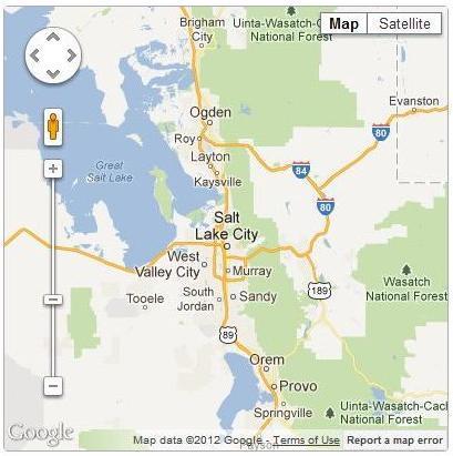
18 Walk and Bike Barrier Locations Example: Salt Lake City Barriers 18

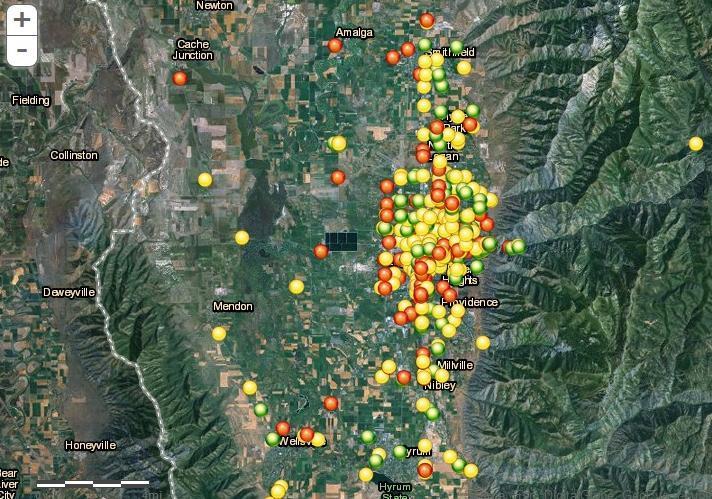
19 Walk and Bike Barrier Hot Spots Example: Salt Lake City Barrier Hot Spots 19
20 Applications Salt Lake area agencies collaborate and are sharing the dataset City of Salt Lake: Data is informing update of Bicycle and Pedestrian Master Plan Study team members and agencies plan to use data for Utah Collaborative Active Transportation Study (UCATS) WFRC planners identifying hot spots for disabled travelers UTA reviewing for transit access issues Potential use for the newly launched SLC Bike Share Engage & share results with residents Cache MPO sharing results on website WFRC considering ways to share results 20

21 Applications 21
22 Closing Thoughts Good method for real-time data for planning Improved targeting of limited dollars Insight into demand for walk and bike infrastructure Potential to adapt the survey to support ongoing data collection Continuous collection of hot spots across several seasons Allow for longer survey administration period to encourage more word of mouth/response Assess trends in barrier data and improve future survey design Identifying and locating problems along roadways Categorization of problem types Coordination with safety and health needs 22
23 Thank You! Questions? Contact information: Chloe Ritter RSG, Inc. Acknowledgements: Wasatch Front Regional Council (WFRC) Mountainland Association of Governments (MAG) Cache MPO Dixie MPO Utah Transit Authority (UTA) Utah DOT 23
MASTER BICYCLE AND PEDESTRIAN PLAN
 VILLAGE OF NORTHBROOK MASTER BICYCLE AND PEDESTRIAN PLAN DRAFT PLAN OPEN HOUSE May 2, 2018 AGENDA 1. Community Engagement 2. Vision and Goals 3. General Structure of Plan 4. Recommendations Overview 5.
Plant City Walk-Bike Plan
 Plant City Walk-Bike Plan Plant City Commute Mode Share 2.2% 1.4% 2.9% Drove alone 10.2% Carpooled Public transportation (0.1%) Walked Used a Bike (0.4%) 82.9% Taxicab, motorcycle, or other means Worked
Bicycle and Pedestrian Connectivity Study. Old Colony Planning Council
 Bicycle and Pedestrian Connectivity Study Old Colony Planning Council Outline Why consider bike/peds in road designs? Why are measures needed? Connecting Land Use with Transportation Evaluation Tools:
Beyond First First Last Last Mile Strategies. APA National Conference April 3, 2016 Chelsea Richer, AICP Fehr & Peers
 Beyond First First Last Last Mile Strategies APA National Conference April 3, 2016 Chelsea Richer, AICP Fehr & Peers 1 Beyond First Last Mile Strategies APA National Conference Jeremy Klop, AICP, Fehr
The Traffic Monitoring Guide: Counting Bicyclists and Pedestrians. APBP 2017 June 28: 11:15am-12:45pm
 The Traffic Monitoring Guide: Counting Bicyclists and Pedestrians APBP 2017 June 28: 11:15am-12:45pm 2 Presentation Organization Why count bicyclists and pedestrians? Why report count data? What resources
International Physical Activity Prevalence Study SELF-ADMINISTERED ENVIRONMENTAL MODULE
 International Physical Activity Prevalence Study SELF-ADMINISTERED ENVIRONMENTAL MODULE There is increasing interest in the contextual (environmental) barriers that prevent or limit the opportunity to
Thank you for attending
 Improving mobility safety comfort WELCOME Thank you for attending The purpose of this meeting is to: Learn about the project Prioritize potential walking and biking improvements on Snelling Ave Gather
MASTER BICYCLE AND PEDESTRIAN PLAN
 WELCOME! PLEASE FEEL FREE TO REVIEW THE EXHIBITS THE PRESENTATION WILL BEGIN AT 6:00 PM VILLAGE OF NORTHBROOK MASTER BICYCLE AND PEDESTRIAN PLAN DRAFT EXISTING CONDITIONS REPORT AND PUBLIC MEETING WELCOME!
NM-POLICY 1: Improve service levels, participation, and options for non-motorized transportation modes throughout the County.
 Transportation PRINCE WILLIAM COUNTY 2008 COMPREHENSIVE PLAN NON-MOTORIZED PLAN CONTENTS Goals, Policies, and Action Strategies Table 4 (Bike Facility Classifications and Descriptions) Table 5 (Bike Facility
92% COMMUTING IN THE METRO. Congested Roadways Mode Share. Roadway Congestion & Mode Share
 COMMUTING IN THE METRO Roadway Congestion & Mode Share The majority of major roadways in Greater Des Moines are without congestion and have underutilized capacity. This surplus capacity could be used for
Southern California Walking/Biking Research And Creative Evaluation
 Southern California Walking/Biking Research And Creative Evaluation Quantitative Research Topline Report December 7, 2015 Background & Objectives The Southern California Association of Governments (SCAG)
Bicycle and Pedestrian Planning in a Historically Car-Centric Culture: A Focus on Connectivity, Safety, & Accessibility
 Bicycle and Pedestrian Planning in a Historically Car-Centric Culture: A Focus on Connectivity, Safety, & Accessibility Kate Horton and Zylavian Watley Transportation Planners Memphis MPO Date: October
CONNECTING PEOPLE TO PLACES
 CONNECTING PEOPLE TO PLACES 82 EAST BENCH MASTER PLAN 07 Introduction The East Bench transportation system is a collection of slow moving, treelined residential streets and major arteries that are the
WALKNBIKE DRAFT PLAN NASHVILLE, TENNESSEE EXECUTIVE SUMMARY NASHVILLE, TENNESSEE
 NASHVILLE, TENNESSEE EXECUTIVE SUMMARY Executive Summary A world-class multi-modal transportation system is essential to a vibrant city and better quality of life. -Mayor Barry The WalknBike plan aims
Madison Urban Area and Dane County. Bicycle Transportation Plan Summary. September Introduction. Bicycle Plan Scope and Planning Process
 Bicycle Transportation Plan Summary Madison Urban Area and Dane County Introduction September 2000 Bicycling is an important mode of transportation in the Madison urban area and countywide that is available
City of Birmingham Draft Multi-modal Transportation Plan
 City of Birmingham Draft Multi-modal Transportation Plan City Commission Public Hearing Monday, November 25, 2013 7:30 pm Norman Cox, PLA, ASLA The Greenway Collaborative, Inc. Ann Arbor, Michigan The
TABLE OF CONTENTS. Executive Summary
 Executive Summary Background... ES-1 Pedestrian Network... ES-2 Bikeway Network... ES-2 Collision History... ES-2 Public Input... ES-4 Conclusions and Recommendations... ES-4 1. Introduction and Setting
Performance Criteria for 2035 Long Range Transportation Plan
 Minimizing Impacts on Natural, Historic, Cultural or Archeological Resources 2035 LRTP Weighting Factor: 7% Objective 1.1: Use appropriate planning and design criteria to protect and enhance the built
The Role of MPOs in Advancing Safe Routes to School through the Transportation Alternatives Program
 The Role of MPOs in Advancing Safe Routes to School through the Transportation Alternatives Program In 2012, Congress made changes to Federal funding for Safe Routes to School that gave some metropolitan
EXECUTIVE SUMMARY. Vision
 Vision Walking and bicycling in Salt Lake City will be safe, convenient, comfortable, and viable transportation options that connect people to places, foster recreational and economic development opportunities,
Corridor Vision Workshop Summary James Madison Elementary February 22,2018
 Corridor Vision Workshop Summary James Madison Elementary February 22,2018 WHY DEVELOP THIS STUDY? Ogden City is planning for better connectivity and access to jobs and housing. Working with area partners,
CITY OF BLOOMINGTON COMPLETE STREETS POLICY
 CITY OF BLOOMINGTON COMPLETE STREETS POLICY POLICY OBJECTIVE: The City of Bloomington will enhance safety, mobility, accessibility and convenience for transportation network users of all ages and abilities,
Instructions for Counting Pedestrians at Intersections. September 2014
 Instructions for Counting Pedestrians at Intersections September 2014 Purpose This document introduces the concept of the pedestrian count and provides instructions for performing a manual intersection
Bicycle Master Plan Goals, Strategies, and Policies
 Bicycle Master Plan Goals, Strategies, and Policies Mobilizing 5 This chapter outlines the overarching goals, action statements, and action items Long Beach will take in order to achieve its vision of
2014 Regional Bicycle and Pedestrian Study Evaluation Tools Leslie A. Meehan, AICP MPO Technical Coordinating Committee Meeting April 1, 2015
 Mayor Mayor Kenneth Karl Dean, Wilber, Chairman 2014 Regional Bicycle and Pedestrian Study Evaluation Tools Leslie A. Meehan, AICP MPO Technical Coordinating Committee Meeting April 1, 2015 Evaluation
February 2018 HIGHWAY 316 IMPROVEMENTS PROJECT
 February 2018 HIGHWAY 316 IMPROVEMENTS PROJECT Agenda 1 2 3 4 5 A Message from the City Project Area Traffic Conditions Pedestrian/Bicycle Comfort & Safety Next Steps Q&A City of Hastings Supports a study
Pinellas County Safety Initiatives
 Florida Department of TRANSPORTATION Pinellas County Safety Initiatives Whit Blanton, FAICP Pinellas County MPO A Distinctive County A unique geography Multi-jurisdictional Key demographics seniors and
CHAPTER 3: Vision Statement and Goals
 Davidson Walks & Rolls: Active Transportation Master Plan CHAPTER 3 Contents: Overview Vision Statement Measurable Goals Public Outreach CHAPTER 3: Vision Statement and Goals Overview The vision statement
Introduction.
 2307-1.0. Introduction. Delaware s Safe Routes to School (SRTS) Program was established September 10, 2002 when Governor Ruth Ann Minner signed Senate Bill 353 of the 141st General Assembly of Delaware
Driverless Vehicles Potential Influence on Bicyclist Facility Preferences
 Driverless Vehicles Potential Influence on Bicyclist Facility Preferences MICHAEL BLAU, MCRP, LCI O T E C O C T O B E R 2 6, 2 0 1 6 S E S S I O N # 8 2 - E V A L U AT I N G T H E P E R F O R M A N C E
APPENDIX A. Outreach Summary
 APPENDIX A Outreach Summary COUNTYWIDE TRANSPORTATION PLAN Summary of Public Outreach and Engagement To gather an understanding of the transportation issues and priorities throughout the county, and inform
El Paso County 2040 Major Transportation Corridors Plan
 El Paso County 2040 Major Transportation Corridors Plan Connect-our-County Online Transportation User Survey Preliminary Results June 24, 2010 Years of Residence 2. How many years have you LIVED HERE?
TULSA CITY COUNCIL CAPITAL IMPROVEMENT PROGRAM TASK FORCE MEETING JANUARY
 CITY OF TULSA BICYCLE & PEDESTRIAN INFRASTRUCTURE TULSA CITY COUNCIL CAPITAL IMPROVEMENT PROGRAM TASK FORCE MEETING JANUARY 31, 2013 CITY OF TULSA ENGINEERING SERVICES DEPARTMENT CITY OF TULSA ADA TRANSITION
The study area for this project is the entire County of Oxford including both the urban centres and rural areas.
 INTRODUCTION In July 2013 Oxford County initiated a study to develop a long term Trails Master Plan. The study is now being undertaken collaboratively with the County, the consultant team from MMM Group
MassDOT s Transportation Choice and Healthy Transportation Policy Initiatives
 MassDOT s Transportation Choice and Healthy Transportation Policy Initiatives Jackie DeWolfe, Director of Sustainable Mobility, MassDOT Michelle Danila, Complete Streets Engineer, MassDOT ACEC April 2018
Appendix C 3. Bicycle / Pedestrian Planning
 Appendix C 3. Bicycle / Pedestrian Planning BICYCLE/PEDESTRIAN PLANNING 2005 Master Plan GOAL: Provide for safe and convenient bicycle and pedestrian circulation throughout the City. Develop a city-wide
Castro Valley Municipal Advisory Council March 19, 2018
 Castro Valley Municipal Advisory Council March 19, 2018 1 Background 2 Draft Bicycle Vision and Pedestrian Networks 3 Next Steps 4 Updates Agenda 2 PROJECT AREA: Unincorporated Areas of Alameda County
EXECUTIVE SUMMARY November 2016
 EXECUTIVE SUMMARY November 2016 Purpose The New Jersey Bicycle and Pedestrian Master Plan presents a vision, goals, and strategies to achieve a transportation system in which walking and bicycling are
Pine Hills Road Pedestrian/Bicycle Safety Study Board of County Commissioners Work Session
 Pine Hills Road Pedestrian/Bicycle Safety Study Board of County Commissioners Work Session February 20, 2018 Meeting Agenda Study Overview Existing Conditions Access Management Potential Gateway Features
Creating Complete Streets to Accommodate All Users
 Creating Complete Streets to Accommodate All Users Peter Lagerwey, Toole Design Group plagerwey@tooledesign.com Brian Dougherty, Seattle DOT brian.dougherty@seattle.gov International Conference on Urban
Complete streets serve the 1/3 of Hoosiers who do not drive.
 Complete Streets Complete streets are safe, comfortable and convenient for all users, including pedestrians, bicyclists, motorists and public transit riders, regardless of age or ability. Complete streets
GIS Based Non-Motorized Transportation Planning APA Ohio Statewide Planning Conference. GIS Assisted Non-Motorized Transportation Planning
 The Purpose of GIS Assisted Network GIS Assisted Non-Motorized Transportation 2011 APA Ohio Statewide Conference Friday, 10:45 AM to Noon Focus on near-term projects wwwgreenwaycollabcom The purpose of
cyclingincities opinion survey ABOUT THE STUDY WHO DID WE ASK? WHAT DID WE DO?
 cyclingincities opinion survey ABOUT THE STUDY Using a bicycle for transportation is good for the environment, and it also offers personal health benefits. Cycling is also feasible, since more than 80%
Goal 3: Foster an environment of partnerships and collaboration to connect our communities and regions to one another.
 Non-Motorized Transportation Plan (NMTP) Draft Vision, Goal and,, Tri-County Regional Planning Commission (TCRPC) Purpose The purpose of the Tri-County Regional Planning Commission (TCRPC) Non-Motorized
Bicycle-Pedestrian Master Plan: Chapters 3 and 4 Distribution
 Bicycle-Pedestrian Master Plan: Chapters 3 and 4 Distribution Finksburg Planning and Citizens Council March 22, 2018 Overview Progress Citizen Outreach Vision Chapter 3 - Existing Conditions Chapter 4
Traffic Safety Barriers to Walking and Bicycling Analysis of CA Add-On Responses to the 2009 NHTS
 Traffic Safety Barriers to Walking and Bicycling Analysis of CA Add-On Responses to the 2009 NHTS NHTS Users Conference June 2011 Robert Schneider, Swati Pande, & John Bigham, University of California
Bike/Multipurpose Trail Study for Glynn County, Georgia MAY 16, 2016
 Bike/Multipurpose Trail Study for Glynn County, Georgia MAY 16, 2016 Agenda» Project Status Update» Draft Recommendations Overview» Next Steps» Questions/Discussion Project Overview» Comprehensive Bikeway
Arlington s Master Transportation Plan
 Arlington s Master Transportation Plan The Master Transportation Plan (MTP) Adopted in eight parts Goals & Policies element and MTP Map adopted in 2007 Bicycle, Pedestrian and Demand and Systems Management
Bringing together community and health. Physical Activity and Nutrition Unit Office of Statewide Health Improvement Initiatives
 Bringing together community and health. Physical Activity and Nutrition Unit Office of Statewide Health Improvement Initiatives Physical Activity and Nutrition Unit Office of Statewide Health Improvement
Improvements Infrastructure Gap Assessment and Improvements Street Striping
 Infrastructure Project Proposal The federal-aid Safe Routes to School program funds infrastructure/engineering projects that fall into two categories: Design (available only to School Development Authority
Hennepin County Pedestrian Plan Public Comment Report
 Hennepin County Pedestrian Plan Public Comment Report On May 31, 2013, the draft Hennepin County Pedestrian Plan was released for a 45-day public comment period ending July 15, 2013. The county received
Eastern PA Trail Summit October 1, 2018
 Eastern PA Trail Summit October 1, 2018 WHO WE ARE + WHY + WE RE * HERE * * * * * * Session Goals: Discuss how to coordinate planning and design in small, urbanized towns Consider how to develop alternative
Community Workshop on the Benefits of a Walkable & Bikeable Community
 Community Workshop on the Benefits of a Walkable & Bikeable Community Overview and Summary On March 12, 2012, the Town of Bethlehem hosted a community workshop to collect ideas and recommendations for
NEWS-CFA: Confirmatory Factor Analysis Scoring for Neighborhood Environment Walkability Scale (Updated: March 15, 2011)
") NEWS-CFA: Confirmatory Factor Analysis Scoring for Neighborhood Environment Walkability Scale (Updated: March 15, 2011) The NEWS is a self-report perceived environment survey originally developed by Saelens
NEWS-CFA: Confirmatory Factor Analysis Scoring for Neighborhood Environment Walkability Scale (Updated: March 15, 2011) The NEWS is a self-report perceived environment survey originally developed by Saelens
Kings County Regional Walk and Bike Plan
 Kings County Regional Walk and Bike Plan Presentation to Corcoran City Council November 13, 2018 Eisen Letunic Transportation, Environmental and Land Use Planning Project objectives Advance local pedestrian/bike
West Village Mobility & Integration
 West Village Mobility & Integration PRESENTED TO TOPCA Town Hall November 9, 2017 [7189-21] Port Credit 2 West Village + Mobility AWalkable Community A CompleteCommunity A SustainableCommunity 3 Mobility
City of Charlottesville Bicycle and Pedestrian Master Plan Update
 City of Charlottesville Bicycle and Pedestrian Master Plan Update September 17, 2014 I. Welcome and meeting overview II. Project status update III. Network overview IV. Break-out groups Pedestrian Network
2018 Transportation Survey October 17, Prepared by:
 Transportation Survey October 17, Prepared by: Overview Methodology Systemwide results Strengths/Weaknesses by mode Importance of possible improvements Conclusions Methodology 500 Chittenden County residents
CONCERNS / CHALLENGES
 CONCERNS / CHALLENGES Time frame Transit Pedestrian Access & Comfort Bicycle Access & Comfort Neighborhood Spillover Public Info & Signange Connection to Downtown Physical Contraints of site 0-5 years
Orinda Bicycle, Trails and Walkways Master Plan
 Orinda Bicycle, Trails and Walkways Master Plan Public Meeting October 15, 2008 Presented by: Ian Moore, Alta Lauren Ledbetter, Alta Bruce Wolff, Alta Introductions City of Orinda Monica Pacheco, Assistant
PRINCE GEORGE S PLAZA METRO AREA PEDESTRIAN PLAN
 PRINCE GEORGE S PLAZA METRO AREA PEDESTRIAN PLAN May 28, 2008 Agenda Welcome and introductions Project overview and issue identification Planning context and strengths Design challenges and initial recommendations
Corpus Christi Metropolitan Transportation Plan Fiscal Year Introduction:
 Introduction: The Safe, Accountable, Flexible, Efficient Transportation Equity Act: A Legacy for Users (SAFETEA-LU) has continued the efforts started through the Intermodal Surface Transportation Efficiency
Today. Develop Plans. Public Listening Session
 Welcome! 1. Share Existing Conditions and Data 2. Share Details of Proposed Project 3. Gather Feedback from Public M Ju ee ly tin 17 g D th a, 2 te 01 : 7 Meeting Purpose and 26th Street Project Timeline
Rail Station Fact Sheet CentrePort/DFW Airport Station
 Rail Station Fact Sheet CentrePort/DFW Airport Station Station Overview CentrePort/DFW Airport Station is located by Statler Boulevard at Breezewood Drive in Fort Worth. Free shuttles connect the station
WILMAPCO Public Opinion Survey Summary of Results
 Wilmington Area Planning Council WILMAPCO Public Opinion Survey Summary of Results Prepared by: 2955 Valmont Road, Suite 300 Boulder, Colorado 80301 t: 303-444-7863 f: 303-444-1145 www.n-r-c.com Table
Commerce Street Complete Street Project from Good Latimer Expressway to Exposition Avenue
 Commerce Street Complete Street Project from Good Latimer Expressway to Exposition Avenue T A N Y A B R O O K S A S S I S T A N T D I R E C T O R M O B I L I T Y P L A N N I N G M O B I L I T Y A N D S
Bikeway action plan. Bicycle Friendly Community Workshop March 5, 2007 Rochester, MN
 Bikeway action plan Summary The was held on March 5, 2007 at the Rochester Mayo Civic Center. The workshop was hosted by Rochester-Olmsted County Planning Department in collaboration with the League of
Agenda. Overview PRINCE GEORGE S PLAZA METRO AREA PEDESTRIAN PLAN
 PRINCE GEORGE S PLAZA METRO AREA PEDESTRIAN PLAN May 28, 2008 Agenda Welcome and introductions Project overview and issue identification Planning context and strengths Design challenges and initial recommendations
Urbana Pedestrian Master Plan
 Urbana Pedestrian Master Plan Recommendations Gabe Lewis, Transportation Planner Champaign County Regional Planning Commission November 15, 2018 Public Meeting #2 Public Input Round #1 Thank You! 10 public
Living Streets Policy
 Living Streets Policy Introduction Living streets balance the needs of motorists, bicyclists, pedestrians and transit riders in ways that promote safety and convenience, enhance community identity, create
Rail Station Fact Sheet University of Dallas Station
 Rail Station Fact Sheet University of Dallas Station Station Overview University of Dallas Station is located on John Carpenter Freeway and west of Loop 12 across from the University of Dallas in Irving.
City of Novi Non-Motorized Master Plan 2011 Executive Summary
 City of Novi Non-Motorized Master Plan 2011 Executive Summary Prepared by: February 28, 2011 Why Plan? Encouraging healthy, active lifestyles through pathway and sidewalk connectivity has been a focus
Chapter 14 PARLIER RELATIONSHIP TO CITY PLANS AND POLICIES. Recommendations to Improve Pedestrian Safety in the City of Parlier (2014)
") Chapter 14 PARLIER This chapter describes the current status and future plans for biking and walking in the City of Parlier. RELATIONSHIP TO CITY PLANS AND POLICIES The Parlier General Plan is the primary
Chapter 14 PARLIER This chapter describes the current status and future plans for biking and walking in the City of Parlier. RELATIONSHIP TO CITY PLANS AND POLICIES The Parlier General Plan is the primary
Community Transportation Plan Acknowledgements
 Community Transportation Plan Acknowledgements The Decatur CTP was developed with participation and guidance from City of Decatur staff, its Resident Boards and Commissions, and numerous residents, business
FM 1092/Murphy Road Access Management Study Pulic Meeting #1. Wednesday, August 31, :00 p.m. 8:00 p.m.
 FM 1092/Murphy Road Access Management Study Pulic Meeting #1 Wednesday, August 31, 2011 6:00 p.m. 8:00 p.m. Introductions Agency Partners H-GAC Missouri City TxDOT Introductions Consulting Team In Association
Pedestrian Project List and Prioritization
 To: Kyle Wagenschutz, City of Memphis CC: From: Anne Conlon and John Cock, Alta Planning + Design Date: December, 2014 Re: Project List Development (Task 3.1-3.2) and Project List Prioritization (Task
Incorporating Health in Regional Transportation Planning
 Mayor Karl Dean, Chairman Incorporating Health in Regional Transportation Planning Leslie A. Meehan, AICP Center TRT Intervention Webinar January 29, 2013 Objectives for Today Background About the Nashville
Exhibit 1 PLANNING COMMISSION AGENDA ITEM
 Exhibit 1 PLANNING COMMISSION AGENDA ITEM Project Name: Grand Junction Circulation Plan Grand Junction Complete Streets Policy Applicant: City of Grand Junction Representative: David Thornton Address:
ASSESSING THE WALKING & BIKING ENVIRONMENT
 ASSESSING THE WALKING & BIKING ENVIRONMENT M A Y 2 0 1 3 Jon Morgan WI DHS ACTIVE COMMUNITY LINE-UP Rationale Why do an audit What s involved in an audit Things to look for and consider Hitting the streets
d+80% d+77% d+55% d+7% d+6% d+18%
 Q1: On average during the summer months, how often do you use a bicycle? This question approximates Question 27 from the 2012 NHTSA Attitudes and Behavior survey: On average, during the summer months,
900 BICYCLE FACILITIES Traffic Engineering Manual
 TABLE OF CONTENTS Part 9 - BICYCLE FACILITIES 900 GENERAL... 9-3 900-1 General Background... 9-3 900-2 Designated Bicycle Routes... 9-3 901 SIGNINGS... 9-4 902 MARKINGS... 9-4 902-1 General... 9-4 902-2
2017 North Texas Regional Bicycle Opinion Survey
 2017 North Texas Regional Bicycle Opinion Survey Sustainable Development Program Kevin Kokes, AICP Public Meetings April, 2018 North Central Texas Council of Governments MPO for the Dallas-Fort Worth Region
Highway 56 Traffic Study Rymal Road to Cemetery Road
 January 31, 2018 6:00 pm 8:00 pm Highway 56 Traffic Study Rymal Road to Cemetery Road City of Hamilton Public Meeting 2 2 Purpose of Public Meeting To review and obtain public input and comments on the
Public Information Centre
 WELCOME Public Information Centre Father Tobin Road Lougheed Middle School - Library Wednesday November 7, 2012 7:00 p.m.to 9:00 p.m. Please sign in Neighbourhood Traffic Calming Guide Background The City
BIKE PLAN CONTENTS GATEWAY
 CONTENTS Acknowledgments...vii Great Rivers Greenway District Board of Directors... vii Great Rivers Greenway District Staff... vii Project Consultants... vii Committees... viii Citizens Advisory Committee
Innovative Urban Bikeway Design:
 Innovative Urban Bikeway Design: A Survey of Cities Cities across the U.S. are improving their streets to make riding a bike a more comfortable and attractive way to get around. Many are installing protected
Pedestrian injuries in San Francisco: distribution, causes, and solutions
 Pedestrian injuries in San Francisco: distribution, causes, and solutions Presentation to the San Francisco Health Commission RAJIV BHATIA, MD, MPH DIRECTOR OF OCCUPATIONAL AND ENVIRONMENTAL HEALTH, SAN
DKS & WASHINGTON COUNTY Washington County Transportation Survey
 PREPARED FOR: DKS & WASHINGTON COUNTY Washington County Transportation Survey April 2013 PREPARED BY: DHM RESEARCH (503) 220-0575 239 NW 13 th Ave., #205, Portland, OR 97209 www.dhmresearch.com 1 INTRODUCTION
San Mateo County Bicycle and Pedestrian Advisory Committee
 San Mateo County Bicycle and Pedestrian Advisory Committee January 19, 2017 Emma Shlaes, Policy Manager About SVBC Mission Our purpose is to create a healthy community, environment, and economy through
Baseline Survey of New Zealanders' Attitudes and Behaviours towards Cycling in Urban Settings
 Baseline Survey of New Zealanders' Attitudes and Behaviours towards Cycling in Urban Settings Highlights 67% of urban New Zealanders, 18 years of age or more own or have access to a bicycle that is in
POLICY AGENDA For Elder Pedestrian Safety
 POLICY AGENDA For Elder Pedestrian Safety Older adults and people with disabilities often have mobility, cognitive, and sensory limitations that affect their behavior as pedestrians and place them at risk
Southcote Road Improvements Class Environmental Assessment Study
 1 Southcote Road Improvements Class Environmental Assessment Study Public Information Centre #1 May 24, 2018 Study Area 2 3 Welcome The Ancaster Transportation Master Plan (2011) outlined a long range
Walkable Community Workshops
 Presented by: Larry McAuliffe Manager, Research Unit, Planning Division New York Metropolitan Transportation Council NYSMPO Conference 2008 Walkable Community Workshops Discussion Topics: I. NYMTC in the
Chapter 5. Complete Streets and Walkable Communities.
 Chapter 5. Complete Streets and Walkable Communities. 5.1 Description of Complete Streets. Cities throughout the world, and specifically the United States, are coming to embrace a new transportation and
How To Encourage More Efficient Transportation in Brazilian Cities
 How To Encourage More Efficient Transportation in Brazilian Cities Todd Litman Victoria Transport Policy Institute Presented Seminar on Discouraging The Use Of Cars São Paulo, Brazil 3 September 2013 Creating
City of Waterloo Complete Streets Policy
 City of Waterloo Complete Streets Policy Chris Hodgson P. Eng City of Waterloo Complete Streets Forum 2011 April 28-29 Toronto Waterloo context: Current population Major employers Universities and student
TxDOT Bicycle Tourism Trails Study Update. April 2017 BAC Meeting April 10, 2017
 AGENDA ITEM 6 TxDOT Bicycle Tourism Trails Study Update April 2017 BAC Meeting April 10, 2017 Agenda Approval of interim products o Present study vision statement, goals, and study objectives o Present
Active Transportation Goals
 Active Transportation Goals - 2017 1. Update shared Regional Priority Bicycle Routes Plan/Map 2. Cities and counties adopt Local Active Transportation Plans [that align with Regional Priority Plan/Map]
Route 29 Solutions Projects
 Route 29 Solutions Route 29 Solutions Projects www.route29solutions.org October 10, 2014 Route 29 Widening to Six Lanes Albemarle County This project will widen a 1.8-mile segment of Route 29 from four
US 41 COMPLETE STREETS CORRIDOR PLANNING STUDY from University Parkway to Whitfield Avenue
 41 US 41 COMPLETE STREETS CORRIDOR PLANNING STUDY from University Parkway to Whitfield Avenue EXECUTIVE SUMMARY DRAFT FEBRUARY 2019 Project Overview The US 41 Complete Streets Corridor Planning Study,