ADOT Maintenance Data Collection Guide
|
|
|
- Domenic Small
- 6 years ago
- Views:
Transcription
1 ADOT Maintenance Data Collection Guide January 1, 2009 Prepared for Arizona Department of Transportation Prepared by Jani Demaree and Cambridge Systematics, Inc. 100 CambridgePark Drive, Suite 400
2 ADOT Maintenance Data Collection Guide 1-2
3 Chapter 1 Introduction ADOT already inspects the condition of its maintained features under its AAA+ program. Updated condition survey procedures will help ADOT move towards level-of-service-based (or LOS-based) program budgeting. This chapter introduces the updated data collection procedures and compares them to those now used. The new procedures build on ADOT s current approach, but simplify and reduce effort through random sampling. 1 Updated Data Collection Procedures ADOT Maintenance has measured the condition of highway features for its AAA+ program for several years. These measurements have been based on the number of features passing a threshold value, or functioning as intended FAI. When compared to the total inventory of that feature, the ratings have been expressed as a percentage. The percent passing could be interpreted as a maintenance level of service. Ratings could also be expressed in the opposite sense, reporting the percentage not functioning as intended, or percent NFAI. ADOT is working to tie levels of service, or LOS, explicitly to maintenance budgeting. Development of a LOS-based budgeting procedure will require some changes in how data on the maintained condition of highway features are collected and reported. Not everything will be changed for example, surveys of vegetation and landscaped areas will be carried out and reported as they have been. In other ADOT Maintenance Data Collection Guide 1-1
4 INTRODUCTION cases LOS values will be computed from data already available in the districts or central office. Even for items where reporting of condition data will change, the maintained features themselves are much the same as those measured in the past, and many guidelines for measurement will likewise be similar to those used in the past. The key changes are as follows: Condition ratings will no longer be reported as functioning as intended or not functioning as intended ( FAI and NFAI ). Rather, condition values will be reported simply as the range of values observed in the field. They are clarified in chapter three (3). The length of highway covered in each annual survey will be reduced by using a sampling approach. Sample sections will be 0.5-mile long. The samples are randomly generated each year using the Maintenance Budgeting Program (MBS). This one change should save significant time and effort. In a few cases there are additional items to be measured, which have not been done in the past. These include conditions of paved surfaces that are important to maintenance but that are not tracked in ADOT s pavement management system, and delineators. 2 Moving to a Graded Approach Maintenance levels of service, or LOS, will be reported differently as part of the linkage to budgeting. In the past LOS has been expressed as the percentage of items passing or FAI, as explained above. In the new approach, LOS will be expressed as letter grades A, B, C, D and F. Plus-and-minus grades may also be used if finer gradations are needed. The updated data collection procedures will support these graded LOS values. 3 Quick Points on Sampling Overview All field inspections of maintained features will take place in highway sample sections that are each 0.5-mile long. A total of a few hundred sample sections will be inspected each year, based on statistical design as well as resources available for conducting the survey. These samples will provide an indication of the total network condition statewide. Samples will be selected in each route under the responsibility of a roadway org this will ensure that highways of different functional classes and geographic locations are sampled each year. The location of the sample section will be selected randomly each year this ensures diversity in the sample set and avoids bias due to unique conditions that may exist at particular locations. ADOT Maintenance Data Collection Guide 1-2
5 INTRODUCTION A randomly selected sample set will be generated each year, and a list of sample sections will be provided to each org. The sample sections will be identified by route and beginning milepost. The length of highway to be inspected will be 0.5 mile, moving in the cardinal direction (increasing mile posts) from the assigned milepost. Only one exception will permit moving this sample section in the field existence of a construction work zone. In this case the sample should be shifted in 0.1-mile increments in the cardinal direction (increasing mile posts) until the sample section no longer includes a work zone. If the construction is at the end of the route; in this case the sample should be shifted in 0.1-mile increments in the non-cardinal direction (decreasing mile posts) until the sample section no longer includes a work zone. If this is the case make sure you notify all other orgs that are inspecting this segment, so everyone is inspecting the same segment. Inspecting a Sample Section The sampling approach changes the way in which data will be collected at the site. Refer to the highway configuration in the sample survey section on the following page. Important points to note: The length of the sample section is 0.5 mile. The width of the sample section extends from right-of-way line to right-of-way line. [(C) And (D) in the sample section on the following page.] Only features that are within this sample area and are maintained by ADOT should be inspected. The sample area will contain the mainline highway lanes and shoulders (A), a frontage road if present (B), adjacent right-of-way, and a median in the case of divided highways. The survey will cover features on all these components within the survey area. Quantities of features will be summed across these components if needed (e.g., pavement surface area will include the sum of the paved areas of all roadway lanes and paved shoulders on all roads). If the section includes an intersection, inspect all ADOT maintained features within the mainline right-of-way except traffic signal equipment (E) and Bridge Decks. Interchange ramps (F), acceleration and deceleration lanes, truck lanes, and turning lanes should be included in the survey. When counting the lanes in the survey section, all of these features should be included as a lane. The sample segment has 7 lanes 4 mainline lanes, 2 frontage road lanes, and 1 ramp. If at either end of ramp there are multiple lanes, count all lanes. If there is a partial lane and there is 2 tenths of a mile or more count it as a lane. Within the sample area, complete the items on the Roadway Survey and the Signing and Striping Survey forms as explained in Chapter 2. In some cases, it may be necessary to count all eligible inventories and then divide the number of deficient inventory by the number of all eligible inventories. ADOT Maintenance Data Collection Guide 1-3
6 INTRODUCTION For example, Survey Item 7 - Unpaved Shoulder Edge Drop-Off, inspectors are asked to estimate the percent of the total length of shoulder with erosion or edge drop-off greater than 2. It is necessary to measure the total length of unpaved shoulders. In the sample section below, there are shoulders on both sides of both lanes of the mainline; both sides of the frontage road; and both sides of the ramps. Once the total length of shoulders is known, divide the total length of eroded shoulder by the total length of shoulders. Example: 4 mainline, 2 ramps, 2 frontage shoulders. The length of the mainline is 2.0 miles, the length of the ramp is 0.4 miles and the length of the frontage is 0.6 miles. This equals 3.0 miles total length. For example, total eroded shoulder equals 1.1 miles (5808 linear feet). Calculation: ( )*100 = 36.67%, so you would circle 30-50% for survey item 7. Sample Survey Section Survey Length = 0.5 Mile A A F E D B E Survey Width = ROW to ROW C ADOT Maintenance Data Collection Guide 1-4
7 INTRODUCTION Acknowledgement The criteria to be used in rating items are based, as closely as possible, on the criteria used in previous AAA+ inspections to maintain continuity. The authors wish to acknowledge the work of Ms. Jani Demaree of ADOT as the source of the photographs and many technical descriptions of features in the following sections. These descriptions have been adapted to conform to the new survey procedures and LOS reporting developed in this study. ADOT Maintenance Data Collection Guide 1-5
8 INTRODUCTION ADOT Maintenance Data Collection Guide 1-6
9 Chapter 2 Survey Forms Inspection results will be recorded on survey forms. These forms provide spaces for general information on the sample segment and for ratings for each survey item. Any extra notes can be written on the back of the sheet. 1 Forms Two separate survey forms should be filled out for each sample segment: A Roadway Maintenance Survey Form, which includes roadway surfaces and shoulders, both paved and unpaved, and roadside, safety, and drainage features; and A Signing and Striping Survey Form, which includes four items related to signing and striping. ADOT Maintenance Data Collection Guide 2-1

10 FORMS Roadway Maintenance Survey Form Signing and Striping Survey Form Chapter 2 provides general instructions for filling out the forms. Detailed descriptions of how to measure each item on the forms are provided in Chapters 3 and 4. The following must be noted on the forms. Date, Inspector, and Phone Number of the person taking the measurements. Org. number; (for the Sign & Striping Form also provide the Roadway org number). Route. Beginning mile post. Total number of lanes in both directions. (Interchange ramps, frontage road lanes, turning lanes, truck lanes, etc. should all be counted as a lane.) Do NOT include Left or Right distress lanes in this count. This is not included on the Signing & Striping form. Identify on the Roadway Maintenance Survey Form which part of the segment is Asphalt or PCCP, utilizing the check boxes provided. Complete survey form on the sample segment. ADOT Maintenance Data Collection Guide 2-2
.")

11 FORMS Select a rating for each item that is relevant to the sample segment. In most cases, you can select a rating by circling the appropriate description or range of values. In cases that have both, Asphalt and PCCP surfaces, place a checkmark to the left of the area where it is located. (Usually there will be only one type of Surface). For some items you are asked to count deficiencies and print this number on the form. A check box is provided if the number of deficiencies exceeds a stated maximum value. For example, suppose you are counting spalls as part of Item 5 PCCP: If the number is less than 20, you would print it in the space provided. ADOT Maintenance Data Collection Guide 2-3


12 FORMS If the number is greater than 20, you would put an X in the box in the final column. For Item 6 Unpaved Shoulder. Circle the statement which represents the segment being measured. If there is NO shoulder at all in the segment place an X in the N/A column. For Item 7 Unpaved Shoulder. Circle the percentage which represents the segment being measured. If there is curb with guardrail in the entire segment put an X in the N/A column. ADOT Maintenance Data Collection Guide 2-4
13 FORMS Place an X in the N/A column if any of the items are absent from the sample segment. For example, if inspecting a segment that does not have any crash attenuators present, you would place an X in the N/A column next to Item 10. Description of filling out the Sign & Striping form Fill out the top portion of the inspection form as directed on page 2-2 of this guide. Indicate what portion of the right of way you are inspecting by placing a check mark in the box(s) located left of Mainline, Frontage, & Ramp. Select a rating for each item that is relevant to the sample segment. In most cases, you can select a rating by circling the appropriate description or range of values. ADOT Maintenance Data Collection Guide 2-5
14 FORMS In the case of Item 1, enter the total number of sign posts that are located in the sample segment and enter the number of bent or damaged posts. In the case of Item 4, if the item is not present at the location you are inspecting place an X in the N/A column. ADOT Maintenance Data Collection Guide 2-6


15 Chapter 3 Roadway Features Survey The Roadway Maintenance Survey Form includes roadway surfaces and shoulders, both paved and unpaved, roadside, safety, and drainage features. 2 Pavement and Shoulders Item 1, Asphalt Pavement, Unfilled Potholes: Count the number of unfilled potholes in all lanes of all roads within the sample area. Enter the total on the form if fewer than 20, write the number in the space provided. If greater than 20, simply check the box at the far right no need for an exact count. Beginning of a Pot Hole Pot Hole ADOT Maintenance Data Collection Guide 3-1
16 ROADWAY FEATURES SURVEY Item 2, Open or Unsealed Cracks in Asphalt Pavement: Open or unsealed cracks are those that have not been previously sealed, or that have been sealed but are now reopened. This inspection category has three entries, one for each of the following types of cracking: a) Alligator Cracking: Alligator cracking typically occurs only in the wheelpaths of roadway lanes (travel lanes only). Estimate the total area of pavement in which open alligator cracking occurs in at least one wheelpath. For this particular type of cracking, do not consider shoulders. For example: there are 4 wheelpaths, or 8 wheelpath halves illustrated below. Three of the wheelpath halves have alligator cracking. Three divided by 8 is 37.5%. In this case you would circle 30-50% on the inspection form. Alligator Cracking Example Mainline Shoulder Alligator Cracking ADOT Maintenance Data Collection Guide 3-2


17 ROADWAY FEATURES SURVEY Alligator Cracking Bad Alligator Cracking b) Other Cracking, Less Than and up to ¼ Wide: Other cracking includes longitudinal, transverse, diagonal, and other cracking, but not alligator cracking. Cracking less than ¼ wide includes hairline cracks and early stages of open cracks. Estimate the total percent area of paved lanes and shoulders on all roadway area that exhibits open cracking of less than ¼ width. Example: If the segment has two lanes, linear feet of continuous cracking would equal 0-5%, linear feet of cracking select 5-10%, feet of cracking select 10-30%, feet of cracking select 30-50%, anything greater than 2640 linear feet of cracking select >50% on survey form. Up to ¼ wide cracking Up to ¼ wide cracking ADOT Maintenance Data Collection Guide 3-3


 of cracking are noted on the survey form.")
18 ROADWAY FEATURES SURVEY c) Other Cracking, Greater Than ¼ Wide: Other cracking includes longitudinal, transverse, diagonal, and other cracking, but not alligator cracking. Cracking greater than ¼ wide includes open cracks of pencil-width or greater. Estimate the total percent area of paved lanes and paved shoulders on entire sample segment that exhibits open cracking of greater than ¼ width. Example: If the segment has two lanes, linear feet of continuous cracking would equal 0-5%, linear feet of cracking select 5-10%, feet of cracking select 10-30%, feet of cracking select 30-50%, anything greater than 2640 linear feet of cracking select >50% on survey form. Greater than ¼ wide cracking Greater than ¼ wide cracking Make sure all 3 types (a through c) of cracking are noted on the survey form. Item 3, Percent Asphalt Surface with Bleeding: Estimate the percent area of all asphalt pavement that is bleeding. Using the same scoring method as Other Cracking (b) and (c). Bleeding Bleeding ADOT Maintenance Data Collection Guide 3-4


19 ROADWAY FEATURES SURVEY Item 4, Percent Asphalt Surface with Raveling: Estimate the percent area of all asphalt pavement that shows wear caused by the loss of aggregate and binder. Raveling Raveling Item 5, Portland Cement Concrete Pavement: Number of Spalls and Faulted or Settled Joints: Count the number of spalls, uneven joints, and open cracks other than joints in all PCCP-paved areas on all lanes in the survey area. Enter the total on the form if less than 20, write the number in the space provided. If greater than 20, simply check the box at the far right no need for an exact count. Note: if there is PCCP there usually isn t Asphaltic Concrete. If both PCCP and AC are present in the survey area please note this using the check boxes on the form. Spalls in need of repair Spalls in need of repair ADOT Maintenance Data Collection Guide 3-5
 on one or both sides of mainline. Some unpaved shoulders may have 2 feet in width, and some may have 10 feet or greater in width. If there is NO shoulder (i.")

20 ROADWAY FEATURES SURVEY Spalls in need of repair Spalls in need of repair Item 6, Unpaved Shoulder: Unpaved Shoulder is the unpaved portion beginning at the edge of pavement (EOP) on one or both sides of mainline. Some unpaved shoulders may have 2 feet in width, and some may have 10 feet or greater in width. If there is NO shoulder (i.e. room for a vehicle to get off of the roadway) in the sample segment place an X in the N/A column. Evaluate the condition of the unpaved shoulder surface in the survey area in terms of smoothness of ride and need for grading or repair. Do not include in the inspection shoulders behind curbs or guardrails. ADOT Maintenance Data Collection Guide 3-6
21 ROADWAY FEATURES SURVEY Unpaved Shoulders Example Edge Striping Inspect unpaved shoulder No unpaved shoulder inspection because guardrail abuts pavement Legend Pavement Unpaved Shoulder Guardrail Paved area is from EOP to EOP Item 7, Unpaved Shoulder Edge Drop-Off: Estimate the percent of the total length of shoulder with erosion or edge drop-off greater than 2. Estimate the percent of the total length of shoulder with erosion from the edge of roadway, including behind curb and guardrail. Erosion is soil displacement due to water or wind disturbance. Shoulder drop-off is a change in elevation along the edge between a paved surface and an unpaved shoulder, usually at an angle from the horizontal of 45 degrees. This includes drop off adjacent a cut ditch. Measure drop off where there is a rolled curb that does not have guardrail. Do not measure drop off where there is curb with guardrail. Circle the combine totals of Erosion and Shoulder Drop-off on the survey form. ADOT Maintenance Data Collection Guide 3-7


22 ROADWAY FEATURES SURVEY Drop-Off Does Not Exceed 2 Inches Drop-Off Exceeds 2 Inches Erosion Erosion 3 Roadside, Safety, and Drainage Item 8, Guardrail: Estimate the percent of the total length of guardrail with one or more of the following deficiencies: Broken or bent rails; Broken or bent posts; Severe corrosion; Loose or broken bolts; or Any other condition requiring repair. ADOT Maintenance Data Collection Guide 3-8

 rather than measure exact lengths.")
23 ROADWAY FEATURES SURVEY Guardrails are used to separate travel lanes from oncoming traffic and to protect traffic from bridge ends and piers, deep fill sections, and other potentially dangerous locations. Inspect all guardrail types (W-Beam, Tri-Beam, Ribbon, Half Moon, etc.) EXCEPT cable barriers, which are included in another survey. When estimating guardrail length, it is sufficient to count panels (12.5 ) rather than measure exact lengths. In Good Condition Broken or Bent Elements ADOT Maintenance Data Collection Guide 3-9


 EXCEPT cable terminals, cable anchors, and")


24 ROADWAY FEATURES SURVEY Item 9, Guardrail and Barrier End Treatments: Indicate if any guardrail or barrier end treatments are missing or damaged. Inspect all end types (extruder terminals, "turned down" sections, cable anchors, sloping concrete end sections, etc.) EXCEPT cable terminals, cable anchors, and terminal anchor ends. Terminal anchor ends are considered to be part of the rail. BCT in Good Condition Missing or Damaged Extruder in Good Condition Extruder Damaged Extruder Back Side DO NOT Measure This Type as an End Treatment ADOT Maintenance Data Collection Guide 3-10


25 ROADWAY FEATURES SURVEY Item 10 Crash Attenuators: Indicate if any crash attenuator elements need repair. Crash attenuators may consist of plastic barrels filled with sand or water or metal units resembling guardrail in a special shock-absorbing configuration. They are placed at interchanges at gore points, usually at on/off ramps, bridge piers, or other obstacles. Damage may consist of broken or tipped-over barrels, loss of filler material, missing lids, or any other condition requiring repair. Barrels In Good Condition Barrels Needs Attention Attenuator In Good Condition Marking is Wrong Attenuator Needs Attention Attenuator In Good Condition Attenuator In Bad Condition Old Attenuator In Good Condition Attenuator In Good Condition ADOT Maintenance Data Collection Guide 3-11


26 ROADWAY FEATURES SURVEY Item 11, Sweeping: Indicate whether the sample segment requires sweeping of litter, dirt, or debris. This item is for PHOENIX & TUCSON METRO AREAS ONLY In Good Condition Needs Sweeping Item 12, Litter: Estimate the amount of litter on or beside the roadway using one of the following designations: No litter - All litter has been removed. Few pieces - Some litter is present, but not distracting from view. Small patches Litter is present in 20% of the area. Unsightly areas Litter is distracting and present in 30% to 50% of the area. Greater Than Half the area Litter is present in more than half of the area. In Good Condition N litter Small Patches ADOT Maintenance Data Collection Guide 3-12


27 ROADWAY FEATURES SURVEY Few Pieces Unsightly Areas Item 13 Fence Panels: Estimate the percent of fence panels missing or damaged. Inspect all chain link and barbed wire fence within the sample section that is maintained by ADOT. In Good Condition Cut or Stretched Wires, Bent Posts, Opening Under Fence ADOT Maintenance Data Collection Guide 3-13

.")


28 ROADWAY FEATURES SURVEY Buried Fence Erosion Below Fence Item 14, Lined Channels: Estimate the percent length of line channels with debris or vegetation. Open channels are typically lined on both sides and the bottom with concrete (three sided channels). They serve to carry water away from the road into a natural water course. Lined channels can run parallel to the road within the right of way or at acute angles to the road. Unpaved and rock covered channels should be inspected as part of Item 15 Unpaved Bladed Ditches. DO NOT inspect lined stream beds or wash channels. In Good Condition 0-5% With Vegetation or Debris 5-10% ADOT Maintenance Data Collection Guide 3-14


29 ROADWAY FEATURES SURVEY Lined Channel 30-50% Lined Channel >50% Lined Channel >50% Un-lined Channel with Concrete Bottom ADOT Maintenance Data Collection Guide 3-15


 in")

30 ROADWAY FEATURES SURVEY Item 15, Unpaved Bladed Ditches: Estimate the length of unpaved bladed ditches with rock, mud slides, debris, or vegetation that will hinder drainage. Unpaved drainage channels run along the roadway and serve to carry water away from the road into natural water courses. Drainage ditches can run parallel to the road within the right of way, or at acute angles to the road. Include all grader ditches (crown ditches) in the inspection. DO NOT inspect stream beds. In Good Condition With Vegetation or Debris Crown Ditch With Vegetation or Debris ADOT Maintenance Data Collection Guide 3-16


31 ROADWAY FEATURES SURVEY Item 16, Pipe Openings, Down Drains, and Other Drainage Features: Estimate the percent of all other drainage features that are silted to a depth >25%. These features include pipe openings, culverts, down drains, drop inlets, catch basins, etc. Culverts and pipes may be metal or concrete conduits crossing under the road or may be used to extend ditches under crossroads or driveways that connect to the road. Their purpose is to carry water through the right of way and away from the road with as little disturbance to the roadway facility as possible. Pipes and culverts may be found as a single unit or in an array containing several units, or "barrels". They may be cylindrical, oval, square, or rectangular in cross-section. Drop inlets and catch basins are drainage devices that collect and divert water. They are usually found on roadside with curb and gutter, median, and in populated areas where water discharge must be more carefully controlled. Drop inlets and catch basins are connected to pipes that convey the water into nearby drainage channels. Count the number of openings in the segment. Divide the total number of openings silted 25% or greater by the total number of openings. Example: A four box culvert would have 8 openings. A single pipe would have 2 openings. A drop inlet or catch basin would have 2 openings, one at the top and one connecting to the pipe or box culvert under the roadway, or down the side of the road. The total in this example is 12 openings. If 4 to 6 openings were silted greater than 25% you would circle 30-50% on the survey form. In Good Condition Silted Pipe opening silted more than 25% Pipe 0-5% Pipe 5-10% ADOT Maintenance Data Collection Guide 3-17


32 ROADWAY FEATURES SURVEY Pipe 10-30% Pipe 0-5% Small Drain 0-5% Small Drain>50% Pipe >50% Box >50% ADOT Maintenance Data Collection Guide 3-18
33 Chapter 4 Signing and Striping Survey The Signing and Striping Survey Form includes four items to be rated, all in daylight. A detailed description of the items on the form is provided in Chapter 2. This chapter provided general instructions for filling out the forms. Date, Inspector, and Phone Number Org. number; for Sign & Striping Form also provide the Roadway org number also. Route Beginning mile post. If different from the segment given at training contact the Roadway Org and Interstate Orgs to make sure the same sample segment is being inspected. Check the appropriate box to identify Mainline, Ramp, or Frontage roads in the sample segment. If there is more than one road type in the sample area, check the respective boxes. Example; if interstate personnel are inspecting just the mainline they would only check the Mainline box. If Regional orgs are inspecting the frontage road and ramps they would check the Frontage & Ramps, boxes. If they were inspecting Mainline, Frontage and Ramps all boxes would be checked. When the two forms from Interstate Crews and Region Crews are looked at together, the checked boxes should coincide with each other. Provide information for the sample segment ADOT Maintenance Data Collection Guide 4-1


34 SIGNING & STRIPING Item 1, Sign Posts: Enter the total number of sign posts in the sample section and number of posts that are bent, damaged, missing or need repair. Inspect all regulatory and informational signs mounted on posts along the road and those mounted on overhead sign or bridge structures. Note: Sign faces will be inspected in another survey. Missing Post Bent Sign Post Missing Sign Item 2, Delineators: Estimate the percent of delineators that are missing, damaged, out of alignment, or not visible. Delineators are reflecting devices mounted in a series along the road to indicate its alignment. This inspection is done by the Signing Crews. Item 3, Striping: Indicate the legibility of pavement striping using one of the following ratings: Very good Lines look like new. Good Lines show some wear, but are still visible. Fading but Legible Lines are chipped or fading, and visibility is reduced. Barely Legible Lines are incomplete and barely visible. Not Legible Lines are obliterated. Very Good Striping Barely Legible Striping ADOT Maintenance Data Collection Guide 4-2


35 SIGNING & STRIPING All pavement striping should be included Solid and broken centerlines, lane lines, and edge lines; Yellow and white stripes; and All materials painted, tape of various types, and thermoplastic. All State highways should have a centerline and two edge lines, including those with curb and gutter, and Jersey barrier. Striping should be inspected during the day. Item 4, Pavement Markings: Indicate the legibility of pavement marking using one of the following ratings: Very good Markings look like new. Good Markings show some wear, but are still visible; Fading but Legible Markings are chipped or fading, and visibility is reduced; Barely Legible Markings are incomplete and barely visible Not Legible Markings are obliterated. Pavement markings include painted and taped crosswalks, channelization, construction/maintenance detour markings, and other pavement messages. Pavement marking should be inspected during the day. Very Good Pavement Marking Good Pavement Marking ADOT Maintenance Data Collection Guide 4-3


36 SIGNING & STRIPING Fading but Legible Pavement Marking Barely Legible Pavement Marking Sign faces will be inspected for Retro Reflectivity, missing or damaged. Retro Reflectivity shall be done at night with the total number of signs inspected and the number of signs that do not meet the reflectivity measurement recorded. The total signs inspected and total signs not meeting the reflectivity criteria are to be turned in to the LOS Administrator. Good Sign Missing Lettering at Night Dead Sign at Night Missing Sign ADOT Maintenance Data Collection Guide 4-4
37 Chapter 5 Rest Area eform The Rest Area Survey eform includes twenty four items to be rated, at least once a month Rest Area Inspection Policy Rest Areas shall be inspected a minimum of once a month Rest Area Residences shall be inspected at least quarterly with monthly inspections recommended. Inspectors shall update the Rest Area eforms as soon as possible, or at least by the end of the month, on so the forms can be electronically used statewide. At least one person and a back up will be responsible for: 1. Rest area inspection of contractual maintenance. 2. Inspecting rest areas for minor and major problems, and ensure repairs are completed in a timely manner. 3. Communication with contractors and the public. 4. Procurement procedures, rules and compliance. 5. Aware of closure and re-opening of rest areas. 6. If a rest area is closed at the time of inspection; under notes on the inspection sheet, document the reason for closure and edit the top inspection sheet as described in the instruction guide. ADOT Maintenance Data Collection Guide 5-1


38 REST AREA E-FORM Interstate Rest Area Non-Interstate Rest Area Getting Familiar with Forms Manager Before we get to the Rest Area eform, we need to get familiar with the eforms application and know how it works. The left side of the screen is called Form Directory. The right side of the screen is called Form Display. The top part is called the Menu Bar. Form Directory Menu Bar ADOT Maintenance Data Collection Guide 5-2

39 REST AREA E-FORM You can open the Procedure for filling out the form from the website if you have any questions on how to fill out or submitting the form. After entering the *required fields at the top of the form, the screen should look like this: Form Display ADOT Maintenance Data Collection Guide 5-3

40 REST AREA E-FORM Submitting the Rest Area Inspection Form Scroll to the bottom of the form and Click on Submit. ADOT Maintenance Data Collection Guide 5-4

41 REST AREA E-FORM Chapter 6 Forms All forms and examples are shown on the following pages. Rest Area eforms are made specifically for each type of Rest Area. The form shown in this document is for a typical Interstate rest area. ADOT Maintenance Data Collection Guide
42 REST AREA E-FORM ADOT Maintenance Data Collection Guide 5-3
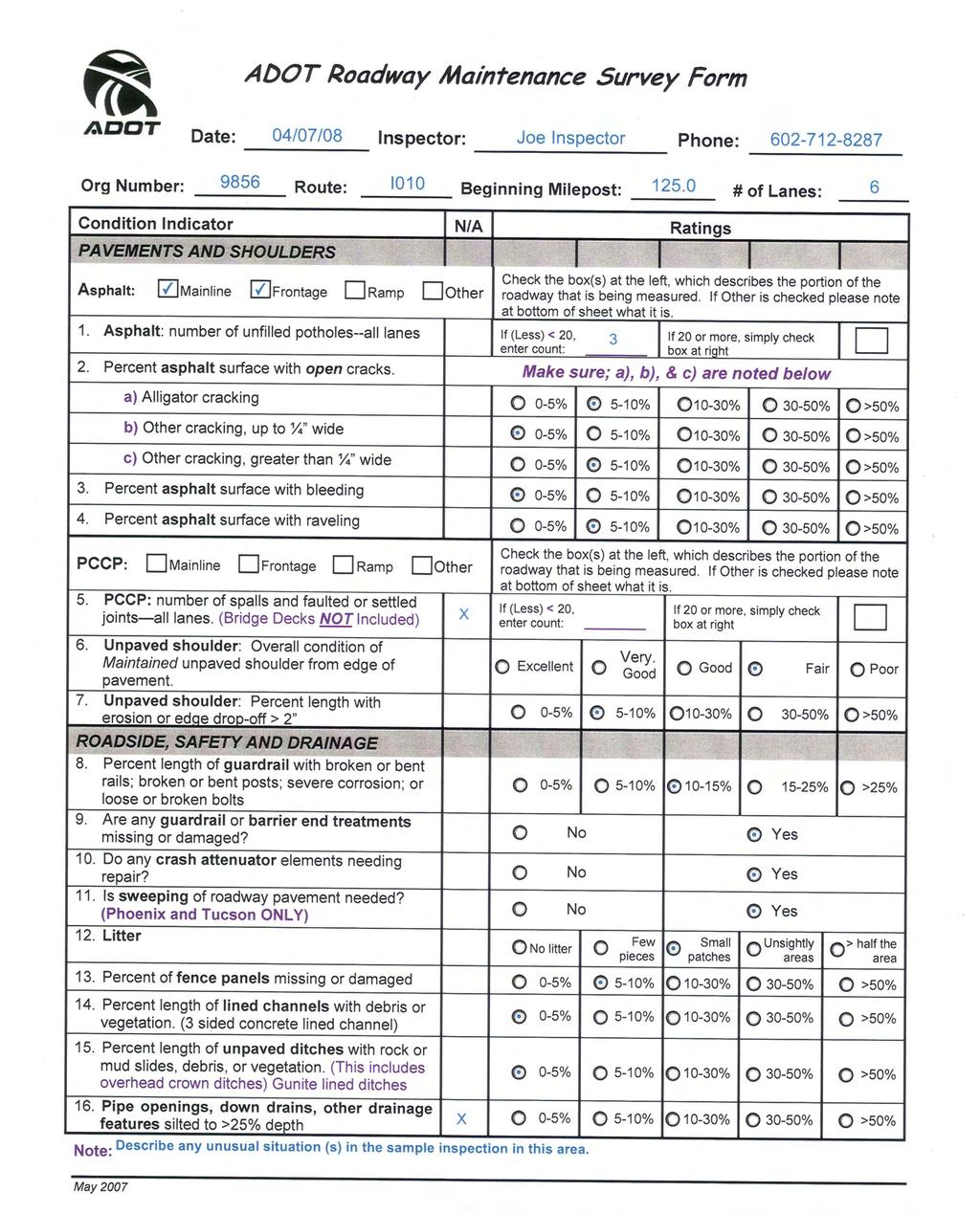
43 ADOT Roadway Maintenance Survey Form Date: Inspector: Phone: Org Number: Route: Beginning Milepost: # of Lanes: Condition Indicator N/A Ratings PAVEMENTS AND SHOULDERS Asphalt: Mainline Frontage Ramp Other 1. Asphalt: number of unfilled potholes--all lanes If (Less) < 20, enter count: Check the box(s) at the left, which describes the portion of the roadway that is being measured. If Other is checked please note at bottom of sheet what it is. If 20 or more, simply check box at right 2. Percent asphalt surface with open cracks. Make sure; a), b), & c) are noted below a) Alligator cracking 0-5% 5-10% 10-30% 30-50% >50% b) Other cracking, up to ¼ wide 0-5% 5-10% 10-30% 30-50% >50% c) Other cracking, greater than ¼ wide 0-5% 5-10% 10-30% 30-50% >50% 3. Percent asphalt surface with bleeding 0-5% 5-10% 10-30% 30-50% >50% 4. Percent asphalt surface with raveling 0-5% 5-10% 10-30% 30-50% >50% PCCP: Mainline Frontage Ramp Other 5. PCCP: number of spalls and faulted or settled joints all lanes. (Bridge Decks NOT Included) 6. Unpaved shoulder: Overall condition of Maintained unpaved shoulder from edge of pavement. 7. Unpaved shoulder: Percent length with erosion or edge drop-off > 2 ROADSIDE, SAFETY AND DRAINAGE 8. Percent length of guardrail with broken or bent rails; broken or bent posts; severe corrosion; or loose or broken bolts 9. Are any guardrail or barrier end treatments missing or damaged? 10. Do any crash attenuator elements needing repair? 11. Is sweeping of roadway pavement needed? (Phoenix and Tucson ONLY) 12. Litter Check the box(s) at the left, which describes the portion of the roadway that is being measured. If Other is checked please note at bottom of sheet what it is. If (Less) < 20, enter count: Excellent Very. Good If 20 or more, simply check box at right Good Fair Poor 0-5% 5-10% 10-30% 30-50% >50% 0-5% 5-10% 10-15% 15-25% >25% No litter No No No Few pieces Small patches Yes Yes Yes Unsightly areas > half the area 13. Percent of fence panels missing or damaged 0-5% 5-10% 10-30% 30-50% >50% 14. Percent length of lined channels with debris or vegetation. (3 sided concrete lined channel) 15. Percent length of unpaved ditches with rock or mud slides, debris, or vegetation. (This includes overhead crown ditches) Gunite lined ditches 16. Pipe openings, down drains, other drainage features silted to >25% depth Note: May % 5-10% 10-30% 30-50% >50% 0-5% 5-10% 10-30% 30-50% >50% 0-5% 5-10% 10-30% 30-50% >50%
44

45 ADOT Sign & Striping Maintenance Survey Form Date: Inspector: Phone: Sign/Stripe Org Number: Roadway Org Number: Route: Beginning Milepost: Condition Indicator N/A Ratings Mainline Frontage Ramp Other Check the box at the left, which describes the portion of the roadway that is being measured. 1. Total number of sign posts in sample section and Number of posts bent or damaged Total Number Number Bent or Damaged 2. Percent of delineators missing, damaged, or not visible. 0-5% 5-10% 10-15% 15-20% >20% 3. Legibility of pavement striping Very Good Good Fading but Legible Barely Legible Not Legible 4. Legibility of pavement markings Very Good Good Fading but Legible Barely Legible Not Legible MILEPOST NOTES October 2008
46
47
48
AMMO Field Data Collection Manual
 AMMO Field Data Collection Manual June 2002 Montana Department of Transportation Maintenance Division Introduction Table of Contents Page Maintenance Activities. 3 Procedures 4 List. 5 Field Data Collection
CHAPTER 8 STAKING SIGNALS AND LIGHTING FIELD GUIDE. 8.1 Staking Traffic Control Signal Systems
 CHAPTER 8 STAKING STAKING Correct staking of traffic control signal or lighting systems is critical to the appropriate placement of system components. 8.1 Traffic Control Signal Systems Locating the components
WYDOT DESIGN GUIDES. Guide for. Non-NHS State Highways
 WYDOT DESIGN GUIDES Guide for Non-NHS State Highways 2014 GUIDE FOR Non-NATIONAL HIGHWAY SYSTEM (Non-NHS) STATE HIGHWAYS PRESERVATION REHABILITATION RECONSTRUCTION INTRODUCTION This Guide is directed to
PLACEMENT OF SIGNS RECOMMENDED PRACTICES SUB-SECTION
 Page 1 of 6 RECOMMENDED PRACTICES PART SECTION SUB-SECTION HIGHWAY SIGNS GENERAL General Proper positioning of signs is an important element in the overall control of traffic within a roadway network.
WORK ZONE TRAFFIC CONTROL PROCEDURES AND GUIDELINES FOR SCDOT MAINTENANCE ACTIVITIES
 WORK ZONE TRAFFIC CONTROL PROCEDURES AND GUIDELINES FOR SCDOT MAINTENANCE ACTIVITIES April 1, 2017 WORK ZONE TRAFFIC CONTROL PROCEDURES AND GUIDELINES FOR SCDOT MAINTENANCE ACTIVITIES Table of Contents
WYDOT DESIGN GUIDES. Guide for. NHS Arterial (Non-Interstate)
") WYDOT DESIGN GUIDES Guide for NHS Arterial (Non-Interstate) 2014 GUIDE FOR NATIONAL HIGHWAY SYSTEM (NHS) HIGHWAYS (NHS ARTERIALS, Non-Interstate) PRESERVATION REHABILITATION RECONSTRUCTION INTRODUCTION
WYDOT DESIGN GUIDES Guide for NHS Arterial (Non-Interstate) 2014 GUIDE FOR NATIONAL HIGHWAY SYSTEM (NHS) HIGHWAYS (NHS ARTERIALS, Non-Interstate) PRESERVATION REHABILITATION RECONSTRUCTION INTRODUCTION
SECTION 1A NEW JERSEY TURNPIKE GEOMETRIC DESIGN
 SECTION 1A NEW JERSEY TURNPIKE GEOMETRIC DESIGN Table of Contents Page No 1A.1 GENERAL...1 1A.1.1 DESIGN CONTROLS...1 1A.2 MAINLINE ROADWAYS...4 1A.2.1 ROADWAY DESIGNATION...4 1A.2.2 DESIGN SPEED...4 1A.2.3
STAKING TRAFFIC CONTROL SIGNAL SYSTEMS
 Locating the components of a traffic control signal is not an exact science; many factors influence the location of the components. These factors include: lane widths, radii, pedestrian curb ramp requirements,
CHAPTER 1 STANDARD PRACTICES
 CHAPTER 1 STANDARD PRACTICES OBJECTIVES 1) Functions and Limitations 2) Standardization of Application 3) Materials 4) Colors 5) Widths and Patterns of Longitudinal Pavement Marking Lines 6) General Principles
City of Roseville Section 13 Design Standards. _Bikeways January 2016 SECTION 13 BIKEWAYS
 SECTION 13 BIKEWAYS 13-1 GENERAL The City of Roseville bikeway standards are designed to insure that transportation and recreational bikeways are constructed in a manner that would provide a safe and comfortable
Non-State Federal Aid Highways. Pavement Condition Ratings. H e r k i m e r a n d O n e i d a C o u n t i e s
 Non-State Federal Aid Highways Pavement Condition Ratings 2010 H e r k i m e r a n d O n e i d a C o u n t i e s 2010 PAVEMENT CONDITION RATINGS for the Non-State Federal Aid Highway System in Herkimer
Appendix B Existing ADOT Data Parameters
 Appendix B Existing ADOT Data Parameters Appendix 08/04/03 HPMS by Item Number All records 1 Year of Submittal 2 State Code 3 English or Metric Reporting Units 4 County Code 5 Section Identification (ID)
Traffic Control Inspection Checklist Segment:
 Traffic Control Inspection Checklist Segment: Simon Contractors Simon Contractors Originator: Description Reviewed by: Initials Date Distribution: Traffic Quality Manager, Site Assistant Traffic Manager
Figure 3B-1. Examples of Two-Lane, Two-Way Marking Applications
 Figure 3B-1. Examples of Two-Lane, Two-Way Marking Applications A - Typical two-lane, two-way marking with passing permitted in both directions B - Typical two-lane, two-way marking with no-passing zones
Alberta Infrastructure HIGHWAY GEOMETRIC DESIGN GUIDE AUGUST 1999
 Alberta Infrastructure HIGHWAY GEOMETRIC DESIGN GUIDE AUGUST 1999,1'(; A ACCELERATION Data on acceleration from stop D-29 Effects of grade D-35 Intersections D-97, D-99 Lanes D-97, F-5, F-7, F-15, F-21,
APPENDIX E Activity Defect Assignment
 APPENDIX E Activity Defect Assignment Activity Defect Pct Applicable 2010-ML - SHALLOW PATCHING (STN - 2010-TL - SHALLOW PATCHING (STN - 2020-ML - DEEP PATCHING (STN - 2020-TL - DEEP PATCHING (STN - 2030-ML
October 2004 REVISIONS (2) SUPERELEVATION DEVELOPMENT 11.3(2)
 SUPERELEVATION DEVELOPMENT 11.3(2)") October 2004 REVISIONS (2) Chapter 11 HORIZONTAL ALIGNMENT SUPERELEVATION DEVELOPMENT 11.3(2) Chapter 12 VERTICAL ALIGNMENT VERTICAL CURVES PASSING SIGHT DISTANCE 12.5(2) VERTICAL CURVES STOPPING SIGHT
October 2004 REVISIONS (2) Chapter 11 HORIZONTAL ALIGNMENT SUPERELEVATION DEVELOPMENT 11.3(2) Chapter 12 VERTICAL ALIGNMENT VERTICAL CURVES PASSING SIGHT DISTANCE 12.5(2) VERTICAL CURVES STOPPING SIGHT
Culvert Safety Inspection Report
 Culvert Safety Inspection Report Facility Federal Structure ID Inspector Name Agency/Consultant Inspection Date LEGEND Haggerty Rd (South) N/A RL/JF GLEG 1/26/2016 9 New Feature Latitude Longitude Struc
ADA on Construction. Guidance for Section C Plan Preparers
 ADA on Construction Guidance for Section C Plan Preparers Some impacts cannot be avoided and those impacts apply to residents, businesses, motorists, and pedestrians alike. However, good planning can minimize
Accommodating Pedestrians in the Work Zone
 Accommodating Pedestrians in the Work Zone Guidance for Section C Plan Preparers Some impacts cannot be avoided and those impacts apply to residents, businesses, motorists, and pedestrians alike. However,
PENNDOT HPMS DATA COLLECTION GUIDE. Bureau of Planning and Research Transportation Planning Division April 2016 (Updated March 2018)
") PENNDOT HPMS DATA COLLECTION GUIDE Bureau of Planning and Research April 2016 (Updated March 2018) State Street Dauphin County NOTES INTRODUCTION The purpose of this document is to provide you with some
PENNDOT HPMS DATA COLLECTION GUIDE Bureau of Planning and Research April 2016 (Updated March 2018) State Street Dauphin County NOTES INTRODUCTION The purpose of this document is to provide you with some
2017 Temporary traffic control guidelines for pedestrians. v.2
 2017 Temporary traffic control guidelines for pedestrians v.2 Temporary Traffic Control Guidelines for Pedestrians (2017) The safety and mobility of pedestrians, cyclists and motorists must be considered
(This page left intentionally blank)
") (This page left intentionally blank) 2011 Edition - Revision 1 Page 553 Section 5A.01 Function CHAPTER 5A. GENERAL 01 A low-volume road shall be defined for this Part of the Manual as follows: A. A low-volume
(This page left intentionally blank) 2011 Edition - Revision 1 Page 553 Section 5A.01 Function CHAPTER 5A. GENERAL 01 A low-volume road shall be defined for this Part of the Manual as follows: A. A low-volume
Road Safety Audit training course. Motorways - safety issues of the motorway design
 Road Safety Audit training course Motorways - safety issues of the motorway design Jesper Mertner, Road safety auditor, COWI A/S 1 ROAD SAFETY AUDITING COURSE Content 1. Safety 2. Cross sections 3. Horizontal
FLORIDA DEPARTMENT OF TRANSPORTATION
 FLORIDA DEPARTMENT OF TRANSPORTATION FLEXIBLE PAVEMENT CONDITION SURVEY HANDBOOK March 2012 STATE MATERIALS OFFICE Table of Contents Title Page List of Tables... i List of Figures... ii Executive Summary...
SPECIAL SPECIFICATION 7581 Performance Based Vegetation Management
 2004 Specifications CSJ 6216-60-001 SPECIAL SPECIFICATION 7581 Performance Based Vegetation Management 1. Description. This item will govern for complete vegetation management of highway rightof-way, including
PENNDOT HPMS DATA COLLECTION GUIDE
 PENNDOT HPMS DATA COLLECTION GUIDE Bureau of Planning and Research April 2016 (Updated September 2017) State Street Dauphin County INTRODUCTION The purpose of this document is to provide you with some
SECTION 3 STREET DESIGN
 3.01 GENERAL SECTION 3 STREET DESIGN For purposes of geometric and structural design, streets shall be classified according to the following table. The City Engineer will determine the class of all proposed
APPENDIX G SIGNAGE AND STRIPING SUPPLEMENT
 APPENDIX G SIGNAGE AND STRIPING SUPPLEMENT DOUGLAS COUNTY SIGNAGE AND STRIPING SUPPLEMENT TO DOUGLAS COUNTY ROADWAY DESIGN & CONSTRUCTION STANDARDS UPDATED MAY 2018 TABLE OF CONTENTS 1.00: GENERAL REQUIREMENTS...
INDEX. Geometric Design Guide for Canadian Roads INDEX
 Acceleration lane, see Lanes, Acceleration Access, 8.1 Access Management and Functional Classification 8.2 Access Management by Design Classification 8.3 Access Configuration 8.4 Building Set-Back Guidelines
Roadside Safety Proven Countermeasures. Emmett McDevitt Transportation Safety Engineer Federal Highway Administration
 Roadside Safety Proven Countermeasures Emmett McDevitt Transportation Safety Engineer Federal Highway Administration Safety Statistics On average each year 43,000 + people die in traffic related crashes.
Access Management Standards
 Access Management Standards Section 1: Application of Access Standards This chapter describes the Department's access management standards for access connections on the county roadway system. The standards
Hospital Link Project Project Update November 2017
 Hospital Link Project Project Update November 2017 General The project provides a link from Riverside Drive and the Transitway to the Hospital Link Road. Construction is well underway. Read on for important
Driveway Design Criteria
 Design Manual Chapter 5 - Roadway Design 5L - Access Management 5L-4 Driveway Design Criteria A. General For efficient and safe operations, access drives and minor public street intersections can be improved
Appendix T CCMP TRAIL TRAFFIC & TRANSPORTATION DESIGN STANDARD
 Appendix T CCMP 3.3.4 TRAIL TRAFFIC & TRANSPORTATION DESIGN STANDARD 3.3.4 Trail Traffic and Transportation Design Multi-use trails have certain design standards, which vary depending on the agency that
FREEWAY AND SERVICE ROAD CONNECTIONS
 EDGE LINE WHITE STOP BAR SERVICE ROAD EDGE LINE DOTTED LINE (5 MARK, 20 GAP) EDGE LINE 4" WHITE BROKEN LINE 12" WHITE DOTTED LINE (5 MARK, 20 GAP) LINE LINE EDGE LINE 300 SERVICE ROAD 1/2 X (500 MAX) CHANNELIZING
An Overview of Mn/DOT s Pavement Condition Rating Procedures and Indices (March 27, 2003)
") An Overview of Mn/DOT s Pavement Condition Rating Procedures and Indices (March 27, 2003) Equipment Mn/DOT currently collects pavement condition data using a Pathway Services, Inc. Video Inspection Vehicle
An Overview of Mn/DOT s Pavement Condition Rating Procedures and Indices (March 27, 2003) Equipment Mn/DOT currently collects pavement condition data using a Pathway Services, Inc. Video Inspection Vehicle
Developed by: The American Traffic Safety Services Association (ATSSA) 15 Riverside Parkway, Suite 100 Fredericksburg, VA
 15 Riverside Parkway, Suite 100 Fredericksburg, VA") Addendum Developed by: The American Traffic Safety Services Association (ATSSA) 15 Riverside Parkway, Suite 100 Fredericksburg, VA 22406-1022 800-272-8772 This material is based upon work supported by
Addendum Developed by: The American Traffic Safety Services Association (ATSSA) 15 Riverside Parkway, Suite 100 Fredericksburg, VA 22406-1022 800-272-8772 This material is based upon work supported by
ROAD OCCUPANCY PERMIT APPLICATION # Damascus Township, 60 Conklin Hill Road, Damascus, PA Tel Fax
 Instructions: For a driveway access permit, fill in sections 1, 2, 3 and 4, and the appropriate drawings and sign. For a Utility access, fill in sections 1, 2, 3 and 5, and figures 1 and 3. Prepare a detailed
CHAPTER 6H. TYPICAL APPLICATIONS
 Section 6H.01 Typical Applications Support: CHAPTER 6H. TYPICAL APPLICATIONS Chapter 6G contains discussions of typical temporary traffic control activities. Chapter 6H presents typical applications for
Appendix Work Zone Traffic Control
 ppendix Work Zone Traffic Control The purpose of this appendix is to present basic guidelines for work zone traffic control and to supplement the Highway Work Zone Safety Checklist. This appendix presents
Bids DECEMBER 21, 2018 AT 2:00 P.M. (EASTERN) (Estimated Cost: $4,700,000.00)
 (Estimated Cost: $4,700,000.00)") General Info Number: PROJECT NO. 43-19-03 Description: BRIDGE DECK REPAIR AND REHABILITATION OHIO TURNPIKE RAMP OVER STATE ROUTE 420 M.P. 71.4, SOUTH BILLMAN ROAD OVER OHIO TURNPIKE M.P. 75.2, WOOD AND
General Info Number: PROJECT NO. 43-19-03 Description: BRIDGE DECK REPAIR AND REHABILITATION OHIO TURNPIKE RAMP OVER STATE ROUTE 420 M.P. 71.4, SOUTH BILLMAN ROAD OVER OHIO TURNPIKE M.P. 75.2, WOOD AND
An Overview of Mn/DOT s Pavement Condition Rating Procedures and Indices (September 2015)
") An Overview of Mn/DOT s Pavement Condition Rating Procedures and Indices (September 2015) Equipment Mn/DOT currently collects pavement condition data using a Pathway Services, Inc. Digital Inspection Vehicle
An Overview of Mn/DOT s Pavement Condition Rating Procedures and Indices (September 2015) Equipment Mn/DOT currently collects pavement condition data using a Pathway Services, Inc. Digital Inspection Vehicle
CHAPTER 6H. TYPICAL APPLICATIONS
 2006 Edition Page 6H-1 CHAPTER 6H. TYPICAL APPLICATIONS Section 6H.01 Typical Applications Support: Whenever the acronym TTC is used in this Chapter, it refers to temporary traffic control. Standard: The
Gerald P. Oliveto, P.E. George Franz NJDOT
 Gerald P. Oliveto, P.E. George Franz NJDOT Bridge preservation is defined as actions or strategies that prevent, delay or reduce deterioration of bridges or bridge elements, restore the function of existing
PROJECT NO. 093 MA 199 H C. FEDERAL NO. xxxx WIKIEUP-WICKENBURG-PHOENIX HIGHWAY TEGNER STREET, ALTERNATIVE 10 PROJECT IMPROVEMENT
 PROJECT NO. 093 MA 199 H 5807 01C FEDERAL NO. xxxx WIKIEUP-WICKENBURG-PHOENI HIGHWAY TEGNER STREET, ALTERNATIVE 10 PROJECT IMPROVEMENT (INTERSECTION IMPROVEMENT) US 93/US 60 FINAL PROJECT ASSESSMENT April
New Measure A Expenditure Categories DEFINITIONS OF ELIGIBLE EXPENDITURES Adopted March 8, 2007
 New Measure A Expenditure Categories DEFINITIONS OF ELIGIBLE EXPENDITURES Adopted March 8, 2007 City Street and County Road Maintenance Program The preservation and keeping of public street and road rights-of-way
Section 3A.04 Colors. Section 3B.10 Approach Markings for Obstructions
 Section 3A.04 Colors Markings shall be yellow, white, red, or blue, or purple. The colors for markings shall conform to the standard highway colors. Black in conjunction with one of the above colors shall
Traffic Signs and Markings. Instructor: Dr. Yahya Sarraj Associate Prof. Of Transportation
 and Markings Instructor: Dr. Yahya Sarraj Associate Prof. Of Transportation Definition; A traffic sign is defined as a device mounted on a fixed or portable support whereby a specific message is conveyed
RURAL HIGHWAY SHOULDERS THAT ACCOMMODATE BICYCLE AND PEDESTRIAN USE (TxDOT Project ) June 7, Presented by: Karen Dixon, Ph.D., P.E.
 June 7, Presented by: Karen Dixon, Ph.D., P.E.") RURAL HIGHWAY SHOULDERS THAT ACCOMMODATE BICYCLE AND PEDESTRIAN USE (TxDOT Project 0-6840) June 7, 2016 Presented by: Karen Dixon, Ph.D., P.E., TTI Team: Kay Fitzpatrick, Raul Avelar, & Subasish Das Project
RURAL HIGHWAY SHOULDERS THAT ACCOMMODATE BICYCLE AND PEDESTRIAN USE (TxDOT Project 0-6840) June 7, 2016 Presented by: Karen Dixon, Ph.D., P.E., TTI Team: Kay Fitzpatrick, Raul Avelar, & Subasish Das Project
FINAL REPORT. Yonkers Creek Migration Barrier Removal Project Wonderstump Road Del Norte County. Submitted By:
 FINAL REPORT Yonkers Creek Migration Barrier Removal Project Wonderstump Road Del Norte County Submitted By: Del Norte County Community Development Department Yonkers Creek Migration Barrier Removal Project
TRAFFIC CONTROL DEVICES FOR LOW VOLUME ROADS
 PART 5. TRAFFIC CONTROL DEVICES FOR LOW VOLUME ROADS TABLE OF CONTENTS Chapter 5A. GENERAL Page Section 5A.1 Function............................................................... 5A-1 5A.2 Application............................................................
CHAPTER 2F. TOLL ROAD SIGNS. Table 2F-1. Toll Road Sign and Plaque Minimum Sizes
 2011 Edition Page 249 Section 2F.01 Scope CHAPTER 2F. TOLL ROAD SIGNS 01 Toll highways are typically limited-access freeway or expressway facilities. A portion of or an entire route might be a toll highway,
Table of Contents. Introduction. Prompt List Arterials and Streets. Prompt List Interchange. Prompt List Intersections. Prompt List Limited Access
 Table of Contents Introduction Prompt List Arterials and Streets Prompt List Interchange Prompt List Intersections Prompt List Limited Access Prompt List MOT Prompt List Pedestrian Bicyclist Prompt List
Existing conditions of each bridge and repair plan are presented in Table
 2.2.2.5 Drainage Structure (1) Bridge Along the concerned section of this project road, there are 4 constructed bridges. The carriageway widths of existing bridges are designed to fit with existing road
Design Criteria. Design Criteria
 F Design Criteria Design Criteria Ministry of Transportation Ministère des Transports DESIGN CRITERIA Page: 1 of 13 WORK PROJECT NO. N/A GO Bloomington Station TYPE OF PROJECT LOCATION Bloomington Road
NOT TO SCALE PUBLIC WORKS STANDARD DETAILS CURB DETAILS DATE: MARCH 2013 FILE NAME: CURB.DWG
 NOT TO SCALE PUBLIC WORKS STANDARD DETAILS CURB DETAILS DATE: MARCH 2013 FILE NAME: CURB.DWG NOT TO SCALE PUBLIC WORKS STANDARD DETAILS SIDEWALK RAMPS DATE: MARCH 2013 FILE NAME: SIDEWALK RAMPS.DWG NOT
Access requests to County streets and roadways are processed through one of the following methods:
 13.1 GENERAL APPLICATION PROCESS Access requests to County streets and roadways are processed through one of the following methods: A. Planned Developments may set general locations for access points.
DISTRIBUTION: Electronic Recipients List TRANSMITTAL LETTER NO. (13-01) MINNESOTA DEPARTMENT OF TRANSPORTATION. MANUAL: Road Design English Manual
 MINNESOTA DEPARTMENT OF TRANSPORTATION. MANUAL: Road Design English Manual") DISTRIBUTION: Electronic Recipients List MINNESOTA DEPARTMENT OF TRANSPORTATION DEVELOPED BY: Design Standards Unit ISSUED BY: Office of Project Management and Technical Support TRANSMITTAL LETTER NO.
DISTRIBUTION: Electronic Recipients List MINNESOTA DEPARTMENT OF TRANSPORTATION DEVELOPED BY: Design Standards Unit ISSUED BY: Office of Project Management and Technical Support TRANSMITTAL LETTER NO.
Paul Huston, P.E., Design-Build Coordinator Chuck Gonderinger, HDR Engineering. Minnesota Department of Transportation (the Department)
") To: From: Paul Huston, P.E., Design-Build Coordinator Chuck Gonderinger, HDR Engineering Date: March 20, 2001 Subject: Roadway Geometric Design Criteria Project: TH 14/218 Design-Build Project, SP 7408-29,
To: From: Paul Huston, P.E., Design-Build Coordinator Chuck Gonderinger, HDR Engineering Date: March 20, 2001 Subject: Roadway Geometric Design Criteria Project: TH 14/218 Design-Build Project, SP 7408-29,
GWINNETT COUNTY DEPARTMENT OF TRANSPORTATION
 GWINNETT COUNTY DEPARTMENT OF TRANSPORTATION 1 of 7 June 20, 2007 GENERAL: The following guidelines shall be used in the determination of the requirement for left turn lanes for development projects and
Pavement Markings (1 of 3)
") Pavement Markings (1 of 3) DESCRIPTION AND DEFINITION Disadvantages Relatively high cost (over typical Crash reduction as yet unknown painted edge line) No tactile effect The STOP AHEAD pavement marking
Pavement Markings (1 of 3) DESCRIPTION AND DEFINITION Disadvantages Relatively high cost (over typical Crash reduction as yet unknown painted edge line) No tactile effect The STOP AHEAD pavement marking
PART A: IDENTIFICATION/LOCATION
 Appendix A. Quick Bus Stop Checklist QUICK BUS STOP CHECKLIST A1 Street Name: PART A: IDENTIFICATION/LOCATION A2 Nearest Cross Street (street name or landmark if mid-block): A3 A4 A5 Bus Route Direction:
Smoothing Out the Bumpy Road Ahead
 Julie Hannah, P.E. Technical Services and Asset Management May 11, 2017 Smoothing Out the Bumpy Road Ahead Nationwide D = Poor, At Risk Conditions & Capacity Pavement Condition & Congestion Nationwide
PART 5. TRAFFIC CONTROL DEVICES FOR LOW-VOLUME ROADS TABLE OF CONTENTS
 2005 Edition Page TC5-1 PART 5. TRAFFIC CONTROL DEVICES FOR LOW-VOLUME ROADS TABLE OF CONTENTS CHAPTER 5A. Section 5A.01 Section 5A.02 Section 5A.03 Section 5A.04 CHAPTER 5B. GENERAL Page Function...5A-1
Street Paving and Sidewalk Policy
 City Commission Policy 600 Street Paving and Sidewalk Policy DEPARTMENT: Public Works DATE ADOPTED: June 7, 1995 DATE OF LAST REVISION: December 10, 2014 Policy No. 600.01 AUTHORITY: PASS City of Tallahassee-Leon
RAILWAY LEVEL CROSSING CHECKLIST Road Safety Review of Railway Crossings
 RAILWAY LEVEL CROSSING CHECKLIST Road Safety Review of Railway Crossings Location: Crossing No. Date of On-Site Inspection: (Day) / / (Night) / / Weather: CHECKLIST 5. - GENERAL TOPICS Level of control
SECTION 48 - TRAFFIC STRIPES AND PAVEMENT MARKINGS TABLE OF CONTENTS
 SECTION 48 - TRAFFIC STRIPES AND PAVEMENT MARKINGS TABLE OF CONTENTS Section Page 48-1 GENERAL...48.1 48-2 THERMOPLASTIC TRAFFIC STRIPES AND PAVEMENT MARKINGS...48.1 48-3 PAINTED TRAFFIC STRIPES AND PAVEMENT
Roadway Design Manual
 Roadway Design Manual Manual Notice Archive by Texas Department of Transportation (512) 302-2453 all rights reserved Manual Notice 2009-1 From: Manual: Mark A. Marek, P.E Roadway Design Manual Effective
WORK ZONE TRAFFIC CONTROL PROCEDURES
 WORK ZONE SETUP / REMOVAL WORK ZONE TRAFFIC CONTROL PROCEDURES When installing a work zone, install the advance warning signs on all approaches prior to installing the traffic control devices. Perform
MNDOT PAVEMENT DESIGN MANUAL
 MNDOT PAVEMENT DESIGN MANUAL Chapter 6 Ramps, Shoulders, Turn Lanes & Miscellaneous Pavements MnDOT Pavement Engineer Date Contents Introduction... 1 600 Ramps and Loops... 1 610 - Shoulders... 2 620 -
Steps to Conducting a Complete Streets Assessment
 Steps to Conducting a Complete Streets Assessment Familiarize yourself with Complete Streets Read through the Complete Streets Assessment Guidelines. This will give you an idea of what Complete Streets
Rio Intersection Traffic Restrictions Begin Monday
 May 18, 2016 8 Rio Intersection Traffic Restrictions Begin Monday This special edition of the Route 29 Solutions e mail newsletter includes everything you need to know about the May 23 through September
Legislative Update Williamsburg Residency
 Hampton Roads District Legislative Update Williamsburg Residency Jim Brewer, Resident Administrator 757-253-5140 Projects Under Way Warwick Boulevard Project http://www.warwickboulevard.org/ Contractors:
City of Wayzata Comprehensive Plan 2030 Transportation Chapter: Appendix A
 A1. Functional Classification Table A-1 illustrates the Metropolitan Council s detailed criteria established for the functional classification of roadways within the Twin Cities Metropolitan Area. Table
Inspector MUST Sign and Date Each Inspection
 Work Area: Applicant: Mercer County Department of Transportation - Highways Division Application and Permit for Road Work in Mercer County, New Jersey NO. East Windsor Ewing Hamilton Hopewell Lawrence
PUBLIC WORKS DEPARTMENT SIGN AND MARKING PROCEDURES AND GUIDELINES
 PUBLIC WORKS DEPARTMENT SIGN AND MARKING PROCEDURES AND GUIDELINES 2015 FORWARD The Revised Code of Washington (RCW) 47.36, Traffic Control Devices, requires the Washington State Department of Transportation
UNDERWATER BRIDGE INSPECTION REPORT STRUCTURE NO CSAH 133 OVER A DITCH ST. LOUIS COUNTY
 UNDERWATER BRIDGE INSPECTION REPORT STRUCTURE NO. 7780 CSAH 133 OVER A DITCH ST. LOUIS COUNTY SEPTEMBER 27, 2012 PREPARED FOR THE MINNESOTA DEPARTMENT OF TRANSPORTATION BY COLLINS ENGINEERS, INC. JOB NO.
PERFORMANCE ACTIVITY 613 IMPACT ATTENUATOR WORK DESCRIPTION 3
 PERFORMANCE ACTIVITY 613 IMPACT ATTENUATOR WORK DESCRIPTION 1 WORK DESCRIPTION 2 WORK DESCRIPTION 3 Install Remove Repair 613 IMPACT ATTENUATOR ACTIVITY DESCRIPTION Repair, install, remove and maintain
Geometric Design Tables
 Design Manual Chapter 5 - Roadway Design 5C - Geometric Design Criteria 5C-1 Geometric Design Tables A. General The following sections present two sets of design criteria tables - Preferred Roadway Elements
AGENDA ITEM 6 D THOMASVILLE ROAD (HERMITAGE BOULEVARD TO LIVE OAK PLANTATION ROAD) ROADWAY SAFETY AUDIT
 ROADWAY SAFETY AUDIT") May 15, 2018 AGENDA ITEM 6 D THOMASVILLE ROAD (HERMITAGE BOULEVARD TO LIVE OAK PLANTATION ROAD) ROADWAY SAFETY AUDIT TYPE OF ITEM: Discussion STATEMENT OF ISSUE The Florida Department of Transportation
May 15, 2018 AGENDA ITEM 6 D THOMASVILLE ROAD (HERMITAGE BOULEVARD TO LIVE OAK PLANTATION ROAD) ROADWAY SAFETY AUDIT TYPE OF ITEM: Discussion STATEMENT OF ISSUE The Florida Department of Transportation
Introduction to Roadway Design
 Chapter Introduction to Roadway Design 1 This chapter lays the foundation for the Roadway Design course. You examine the roadway design workflow and the completed drawing files and review the project scope,
SECTION TRAFFIC REGULATIONS
 SECTION 01550 TRAFFIC REGULATIONS PART 1 - GENERAL 1.01 OBJECTIVES A. The Contractor shall provide for safe movement of vehicular, bicycle and pedestrian traffic, including persons with disabilities in
CHAPTER 3A. GENERAL PAGE CHAPTER 3B. PAVEMENT AND CURB MARKINGS PAGE
 Virginia Supplement to the 2009 MUTCD Revision 1 Page TC-3-1 PART 3. MARKINGS CHAPTER 3A. GENERAL PAGE Section 3A.01 Functions and Limitations Section 3A.02 Standardization of Application Section 3A.03
Presented By: Jim Roth, P.E. Signing Engineer Office of Traffic Engineering Ohio Department of Transportation 1980 West Broad Street Columbus, Ohio
 1 Presented By: Jim Roth, P.E. Signing Engineer Office of Traffic Engineering Ohio Department of Transportation 1980 West Broad Street Columbus, Ohio 43223 (614) 752-0438 Fax: (614) 644-8199 jim.roth@dot.state.oh.us
Including Revision 1 dated May 2012 and Revision 2 dated May 2012
 Including Revision 1 dated May 2012 and Revision 2 dated May 2012 Page 634 2009 Edition Notes for Figure 6H-1 Typical pplication 1 Work eyond the Shoulder 1. If the work space is in the median of a divided
SECTION 48 - TRAFFIC STRIPES AND PAVEMENT MARKINGS TABLE OF CONTENTS
 SECTION 48 - TRAFFIC STRIPES AND PAVEMENT MARKINGS TABLE OF CONTENTS Section Page 48-1 GENERAL... 48.1 48-2 THERMOPLASTIC TRAFFIC STRIPES AND PAVEMENT MARKINGS... 48.1 48-3 PAINTED TRAFFIC STRIPES AND
Kentucky s Surface Transportation System
 Kentucky s Surface Transportation System ROAD AND BRIDGE CONDITIONS, TRAFFIC SAFETY, TRAVEL TRENDS, AND NEEDS MARCH 2018 PREPARED BY WWW.TRIPNET.ORG Founded in 1971, TRIP of Washington, DC, is a nonprofit
Hospital Link Project Project Update September 2017
 Hospital Link Project Project Update September 2017 General The project provides a link from Riverside Drive and the Transitway to the Hospital Link Road. Construction is well underway. Read on for important
FOR LOOP RAMPS-TAPERED DECELERATION LANE
 6" WHITE DOTTED LINE: 5 MARK, 20 SKIP 6" WHITE CRYSTAL MONO-DIRECTIONAL MAIN LINE END (EVERY 50 FEET) 50 FEET BEYOND LAST CRYSTAL PAVEMENT MARKER 5 AMBER MONO-DIRECTIONAL 50 FEET BEFORE LAST CRYSTAL PAVEMENT
H8 Signs, Supports and Poles
 Alberta Infrastructure and Transportation Roadside Design Guide November 2007 H8 Signs, Supports and Poles H8.1 Introduction This section identifies the appropriate roadside safety treatment for signs,
County of Greenville South Carolina. Traffic Calming Program Neighborhood Traffic Education Program and Speed Hump Program
 County of Greenville South Carolina Traffic Calming Program Neighborhood Traffic Education Program and Speed Hump Program (rev) August 2008 I. PURPOSE The potential negative impacts from vehicular traffic
Department of Public Works Office of Disability Affairs February 23, 2017 Presented by Mark Zwoyer, PE
 ADA Ramp Construction Department of Public Works Office of Disability Affairs February 23, 2017 Presented by Mark Zwoyer, PE Agenda Opening Statements/Welcome PROWAG, ADAAG, INDOT and DPW Standards Inspector
Chapter V TRAFFIC CONTROLS. Tewodros N.
 Chapter V TRAFFIC CONTROLS www.tnigatu.wordpress.com tedynihe@gmail.com Lecture Overview Traffic markings Longitudinal markings Transverse markings Object markers and delineator Traffic signs Regulatory
2004 Traffic and Safety Notes. Cross Reference between the Old Note Number and the New Note Number
 Michigan Department of Transportation 2004 Traffic and Safety Notes Cross Reference between the Old Note Number and the New Note Number OLD NEW Number Number Title (Prior to 2004) 1.1.1 101-Series General
Chapter 4 On-Road Bikeways
 Chapter 4: 4-1.0 Introduction On-Road Bikeways This chapter provides guidelines to help select and design safe on-road bikeways. On-road bikeways include bicycle lanes, shared lanes, shoulders, and wide
Shoulders. Chapter 4: chapter contents
 Chapter 4: Shoulders chapter contents Characteristics of Well-Maintained Shoulders 73 Optimal Timing/Conditions for Maintenance 73 Shoulder Maintenance Issues 74 Shoulder Maintenance Activities 75 Repairing
County of Spartanburg South Carolina
 County of Spartanburg South Carolina Traffic Calming Program June 2012 (Revised/Program on Hold) PURPOSE The potential negative impacts from vehicular traffic on residential roads have been a longstanding
ENGINEERING AND PUBLIC WORKS. Transportation Improvements: Santa s Village Road (MR15) Public Meeting
 Public Meeting") ENGINEERING AND PUBLIC WORKS Transportation Improvements: Santa s Village Road (MR15) Public Meeting March 22, 2018 Agenda Welcome and Introductions Fred Jahn: Commissioner of Engineering and Public Works
ENGINEERING AND PUBLIC WORKS Transportation Improvements: Santa s Village Road (MR15) Public Meeting March 22, 2018 Agenda Welcome and Introductions Fred Jahn: Commissioner of Engineering and Public Works
Secondary Road Program
 Secondary Road Program Joint Legislative Transportation Oversight Committee October 5, 2012 1 Secondary Roads Program The Big Picture The Secondary Road System Needs and Project Types Paved and Unpaved