Section One: Project Summary
|
|
|
- May Harrell
- 6 years ago
- Views:
Transcription
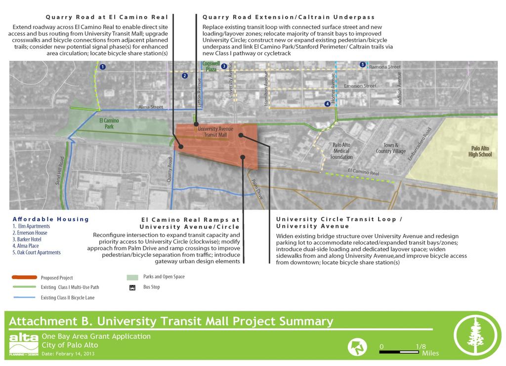
1 ONEBAYAREA GRANT (OBAG) APPLICATION Section One: Project Summary Project Title Brief Project Summary University Avenue Transit Mall Improvements The University Avenue Caltrain Station is the second busiest Caltrain Station behind San Francisco, supporting commuters to Stanford University and the Stanford University Medical Center, Downtown, and Stanford Shopping Center. Several regional transit agencies and dozens of private shuttles to regional employers service the station, but only the VTA uses the existing Palo Alto Transit Center (aka, University Avenue Transit Mall). In 2012 the City completed a preliminary transit analysis with the VTA, Samtrans, and Stanford Marguerite, the three major transit operators, at the University Avenue Transit Mall to identify improvements as part of future development activities adjacent to the Palo Alto Transit Center. The City is in the process of starting a Traffic Impact Analysis study for the planned improvements. The University Avenue Transit Mall Improvements project, through the One Bay Area Grant program, provides a partnership to implement the City s vision for improvements at the Center including: New Quarry Road Extension to provide direct transit access to El Camino Real for enhanced service and access Demolishing the existing VTA Transit Mall New University Loop Transit Mall to consolidate transit access by the three major transit operators, expand transit stop stations for growing regional demand, and enhanced customer access to the Caltrain platform Expanded transit access at the El Camino Real ramps to University Avenue and Westin Hotel parking lot where a public private partnership will allow for additional transit shelter opportunities Enhanced pedestrian and bicycle connections to Downtown Palo Alto through a new underpass to Lytton Avenue and expanded trail connections to Stanford Shopping Center
2 OneBayAreaGrant (OBAG) Application Program Component Agency Guarantee Project Discretionary Complete Streets Project Grant Funds Requested ($) Check all that apply Minimum Discretionary Grant Requested $350,000 Surface Transportation Program (STP) Amount Requested $10,000,000 Congestion Mitigation and Air Quality Improvement (CMAQ) Amount Requested $5,800,000 Transportation Alternatives (TA) Amount Requested $8,000,000 Grant Funds Fiscal Year Local Match (11.47% Min) $10,200,000 (30 percent) Total Project Cost $34,000,000 Member Agency Contact Person City of Palo Alto Jaime O. Rodriguez, Principal Transportation Planner Address 250 Hamilton Avenue, Palo Alto, CA Address Phone (650) Fax (650) Other Project Partners Valley Transportation Authority (VTA), Caltrain, San Mateo Transit Authority (SamTrans), Stanford University, Caltrans 2 University Avenue Transit Mall Improvements

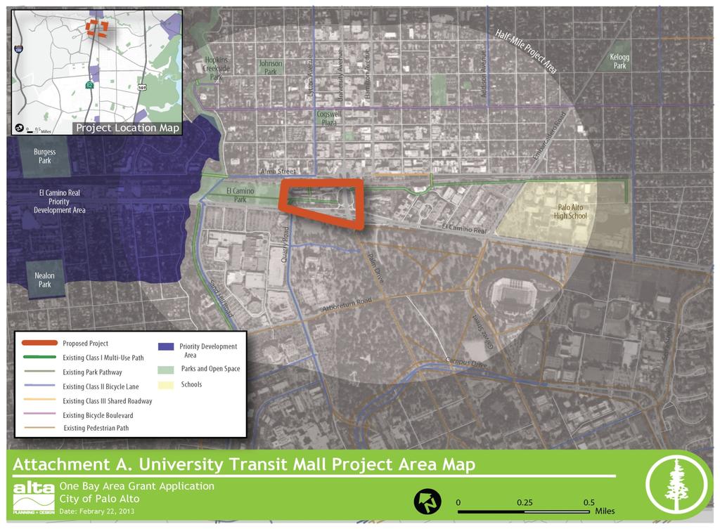
3 City of Palo Alto Section One: Project Summary continued 1. For the Complete Streets Competitive program, include a map that clearly identifies the project s location within a Priority Development Area or proximate access to a PDA. This project is primarily within the Cores, Corridors, and Station Areas PDA (San Mateo County), as shown in Attachment A. As a regional transit and employment hub sandwiched between downtown Palo Alto and Stanford University, the project site is one of the most active, urban areas within Santa Clara County. 2. Project Summary Sheet Attachment B provides an overview of the project area, including locations of key trip attractors and generators within a half mile of the project, including the University Avenue Caltrain Station, VTA buses, Marguerite Shuttle, Palo Alto Medical Center, Stanford University Stadium and sports fields, Town & Country Village Center, downtown Palo Alto, and Palo Alto High School. The University Transit Mall Improvements Project would relocate the existing bus terminal facility to a widened University Circle loop to increase bus pick up and layover capacity, while improving service efficiencies and circulation by extending Quarry Road north of El Camino Real. The resulting roadway and transit center network would support a new Arts & Innovation District that will knit together downtown Palo Alto and the Stanford Shopping Center directly adjacent to the busiest Caltrain station outside of San Francisco. University Avenue Transit Mall Improvements 3

 and electrified Caltrain service planned within the next few years, and a serious")

4 OneBayAreaGrant (OBAG) Application Despite high transit patronage and levels of non motorized activity, the existing transit mall s inefficient configuration severely limits overall person carrying capacity, transit oriented development potential, and connectivity between downtown Palo Alto and Stanford University. With new Bus Rapid Transit (BRT) and electrified Caltrain service planned within the next few years, and a serious development proposal being considered by the City, the discretionary Complete Streets OBAG process provides one of the best opportunities to realize long sought improvements to this regional transit hub and employment center. 4 University Avenue Transit Mall Improvements
5 City of Palo Alto Section Two: Project Narrative Pre Screening Criteria Complete Streets Act Compliance: An adopted Complete Streets policy resolution no later than January 31, 2013 or proof of a General Plan compliant with the Complete Streets Act of A General Plan Housing Element adopted and certified by the California Department of Housing and Community Development for Regional Housing Need Allocation (RHNA) prior to January 31, NOTE: The City of Palo Alto has requested and received an extension of the deadline for certification by HCD to January 31, Screening Criteria 1. VTP 2040 Consistency (VTP 2035) T13: Palo Alto Intermodal Center Expand the Palo Alto Caltrain Station and Bus Transit Center (VTP 2040) Preliminary Financially Constrained Project List (Draft) Same Project 2. MTC Complete Streets Checklist Below are summary responses to each question included in the MTC Complete Streets checklist. A more formal checklist will be prepared, if necessary, upon approval of the funding application. 1. Existing Conditions The transit mall is currently accessed via a two lane University Circle loop road that forces buses back onto University Avenue at the awkward intersection with the northbound El Camino on ramp. Due to a lack of curb space, existing bus layover activities take place on surrounding surface streets, which reduces transit service efficiencies and increases unnecessary trips on already stressed regional roadways. Existing roadway, tunnel, and sidewalk configurations also result in poor pedestrian and bicycle connectivity. 2. Demand The University Transit Mall is directly adjacent to the busiest Caltrain station in Santa Clara County, with over 4,000 total weekly boarding s, including 400 daily passenger bicyclists. Twenty transit routes including VTA, SamTrans, AC Transit Dumbarton Express, and Stanford Marguerite shuttles directly service the transit mall. University Avenue Transit Mall Improvements 5
6 OneBayAreaGrant (OBAG) Application Additional service, including City of Palo Alto and City of Menlo Park shuttles, also serve the transit center from adjacent roadways. These services are sandwiched between the major employment and retail destinations of downtown Palo Alto and Stanford Shopping Center, with additional demand from Stanford University, Stanford Medical Center, Palo Alto Medical Foundation, and nearby hotels. 3. Collisions Yes. The 2012 Bicycle + Pedestrian Transportation Plan identifies a significant number of non motorized collisions surrounding the transit center (see Figures 1 and 2 of the application), which include hot spot locations that can be reconfigured or avoided to improve safety. 4. Plans The 2012 City of Palo Alto Bicycle + Pedestrian Transportation Plan, 2012 Palo Alto Rail Corridor Study, City of Palo Alto Capital Improvement Program/Comprehensive Plan, El Camino Real Master Planning Study (2007), VTP 2035, Caltrain Bicycle and Parking Access Plan, and various other historic plans all envision circulation and transit capacity improvements to the Palo Alto Transit Center/University Transit Mall. These plans have, most recently, been distilled into the development proposal for the 27 University Avenue Arts & Innovation District concept. 5. Policies, Design Standards and Guidelines All applicable Caltrans, Caltrain, and VTA design guidelines and transit policies will be included in the design of this project. 6. Review This project site has been extensively studied for multi modal, complete station improvements for well over two decades. As a complex and dynamic site, details of various proposals have changed, but most of the key shared concepts are included in this project proposal. These include a new bicycle friendly underpass of the Caltrain Station at Lytton Avenue and reconfiguration of the University Avenue and El Camino Real intersection(s). 7. Scope This project entirely consists of pedestrian, bicyclist, and transit accommodations, including grade separated underpass and sidewalk/trail improvements to local and regional surface streets. 8. Hindering Bicyclists/Pedestrians Yes, the project is centrally about addressing barriers to non motorized circulation and transit access, with additional focus on transit capacity enhancements to coincide with improved regional BRT and commuter rail services. 9. Construction Period Temporary traffic control will include safety signage and/or detours for pedestrians and bicyclists consistent with applicable local guidelines and best practices. 10. Ongoing Maintenance The City of Palo Alto will be responsible for the ongoing maintenance of most of these improvements. Funding for the maintenance of local roadways and bicycle facilities is included in the City s Capital Improvement Program 6 University Avenue Transit Mall Improvements

 at Lytton Avenue,")
7 City of Palo Alto (CIP). A maintenance agreement with VTA, Caltrans, Stanford University, and potential private property owners/tenants would likely be needed in advance of final design and construction. 3. PDA and proximate access locations See Attachment A. Criteria 1. Safety This project will greatly improve safety, circulation and access to and through the Palo Alto Transit Center by establishing a new Across Barrier Connection (underpass) at Lytton Avenue, reconfiguring the problematic intersections of the El Camino Real northbound ramps/university Avenue, and developing new Class I trail facilities separated from transit and regional automobile traffic. The project area is currently characterized by sub standard pedestrian and bicycle crossings of the Caltrain tracks and automobile circulation is challenging. Bicycle counts from 1997 found this area to have the highest volumes of bicycle use in the City, which are confirmed by 2011 Caltrain ridership counts that show over 4,000 daily boardings, including over 400 bicyclist passengers. As the area develops with planned construction, new uses will increase traffic from all modes. Figure 1: Pedestrian Collisions ( ) and Figure 2: Bicycle Collisions ( ) The City of Palo Alto Bicycle + Pedestrian Transportation Plan 2012 identifies a significant number of pedestrian collisions (top image) and bicycle collisions (bottom image) in the vicinity of the Palo Alto Transit Center, including conflict hot spots at High Street and University Avenue, the El Camino Real off on ramps, and Alma Street at the Caltrain station entrance. These locations would each experience safety benefits by improved circulation across key barriers, enhanced transit service, and coordinated urban design. University Avenue Transit Mall Improvements 7
8 OneBayAreaGrant (OBAG) Application Automobile traffic accessing the Caltrain station is also currently challenging, and several locations require long pedestrian crossings where drivers are likely to be turning to access the parking lot. The 2008 Caltrain Bicycle Parking and Access Plan notes that the University Avenue undercrossing is narrow with no shoulders or bike lanes and that the three pedestrian undercrossings all require bicyclists to dismount. 2. Project Benefits The benefits of this major overhaul to one of the busiest regional transit hubs in Santa Clara County are numerous and shared between all modes. They are also multi faceted, involving the nexus of transit, land use, economic development, and urban design that is envisioned and promoted by the Bay Area FOCUS and Sustainable Communities Strategy initiatives. Expanded Transit Capacity for Future Anticipated Demand There is a substantial transit capacity issue at the University Avenue Transit Mall due to the inefficient bus circulation and expected increases in transit service and ridership over the next decade. This project more than doubles the capacity of the existing University Loop, improves the efficiency of layover and turnaround routes, and opens up more direct routing options onto El Camino Real and Quarry Road that will improve service routing to/from Stanford Shopping Center/University/Medical Center. In addition to increased transit capacity along a consolidated curb line, the project s proposed underpass and bicycle trail components will help reduce potential congestion impacts to transit from pedestrian surges and bicycle traffic. Regional Trailhead Bicycle counts both near the University Transit Mall and on Caltrain confirm that this area experiences some of the highest volumes of bicyclists in the City, if not the County. The existing Caltrain Path toward Palo Alto High School and the Homer Street Underpass are key facilities for many riders, as are bicycle lanes on Quarry Road, trails within El Camino Park toward Sand Hill Road and Menlo Park, and designated bicycle routes from numerous downtown streets. In addition, Stanford University has a funded project to complete a Perimeter Trail along their frontage with El Camino Real from Quarry Road all the way to Stanford Avenue, and along Stanford Avenue out to Junipero Serra. This project will provide a hub of dedicated bicycle and trail facilities that will link these regionally significant bikeways to and through the transit center, adjacent to major employment centers, and with each other. This hub and spoke network of trails and bikeways will provide a 8 University Avenue Transit Mall Improvements
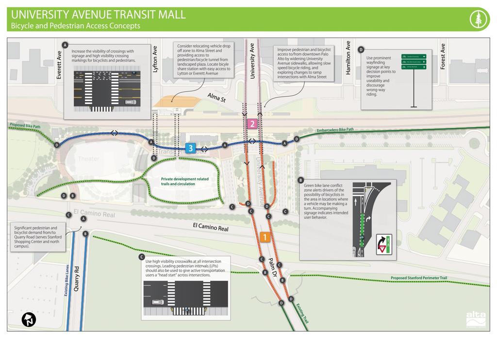
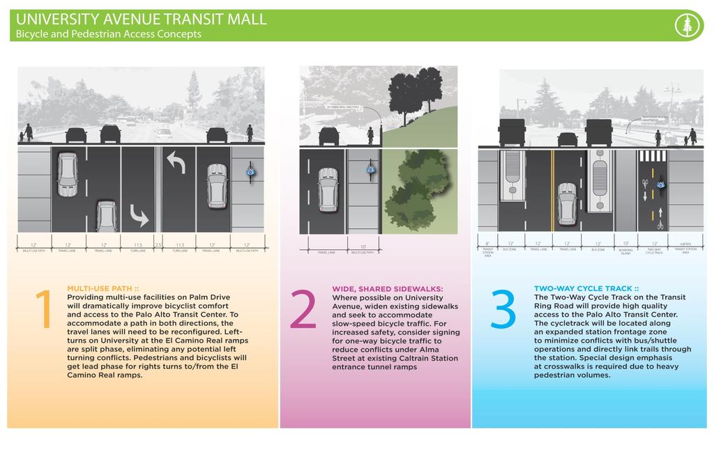
9 City of Palo Alto safe, attractive, and efficient alternative to driving for short and mid range trips, particularly since the Bay Area Bike Share (BABS) program will include stations at the transit center, in downtown, and on the Stanford University campus. Arts & Innovation District Integral to, but beyond the benefits stated above, is the opportunity to the development of a new Arts and Innovation District though a partnership with Stanford University. This project proposes to consolidate a collection of centrally located but underutilized and poorly organized parcels in order to develop the new district which may house a theatre. While the exact composition of uses and potential traffic impacts are undergoing further analysis by the City, what is clear is that this reorganization of space is critical to the feasibility of the transit capacity enhancement and Quarry Road extension concepts. Serving to improve local site access, but also to realize longstanding community goals of improved connectivity for walking, biking, and transit the project supports innovative public private partnership opportunities. 3. Gap Closure/Connectivity The Caltrain tracks are a major east west barrier in Palo Alto. Despite three non motorized underpasses at the University Avenue Transit Mall (one within the transit center near Lytton Avenue, and the other two along both sides of University Avenue), none are wide enough to allow bicycle riding or connect well to existing bikeways west/south of the station. These connections are further compromised by the busy Alma Street corridor, which links to University Avenue via a series of uncontrolled roadway ramps that break up the sidewalk environment. Another primary barrier to improved bikeway linkages is the existing transit mall itself, which would be relocated with the proposed project. Current conditions force users of the Caltrain pathway, El Camino Park trail, and Quarry Road bike lanes to navigate through shared vehicle and transit lanes, which is especially difficult during peak commute periods. Lastly, the El Camino Real corridor is a well known barrier between Stanford University and downtown Palo Alto, and is particularly problematic at the approach to University Avenue from Palm Drive, which lacks bike lanes and includes numerous uncontrolled intersection crossings amid high vehicle speeds and volumes. University Avenue Transit Mall Improvements 9

10 OneBayAreaGrant (OBAG) Application The University Transit Mall Improvements Project is an essential component of the City Center concept articulated by the Palo Alto Rail Corridor Study. That planning process identified a vision to create a vibrant, attractive, transit rich area with city and neighborhood centers that provide walkable, pedestrian and bicycle friendly places that serve the community and beyond; and to connect the east and west portions of the city through an improved circulation network that binds the city together in all directions. 4. Air Quality Improvements and/or Vehicle Miles Traveled (VMT) Reduced This project would likely result in significant reductions in VMT and greenhouse gases, since it encourages all forms of green travel including commuter rail, express bus, BRT, local bus, community shuttles, and bicycle share. The Safe Routes to Transit (SR2T) program provided $500,000 to the VTA Pilot Bike Sharing program. In 2010, $4.3 million was secured through MTC s Climate Initiatives Program to develop an initial bike share program with 1,000 bicycles along the Caltrain corridor in the cities of San Francisco, Redwood City, Palo Alto, Mountain View, and San Jose. A hundred bicycles (out of 1,000) are earmarked for Palo Alto, which will consist of large hub stations at the Palo Alto Transit Center and California Avenue Caltrain stations and a small number of pod stations at select sites in downtown Palo Alto and Stanford University. These stations are expected to become operational before the end of the current year. Providing enhanced transit and last mile capacity, all while serving to remove longstanding barriers to walking and biking between activity centers, is a recipe for reduced automobile use particularly since a repaired connection from the Stanford Shopping Center into downtown would likely result in fewer car trips between these destinations and greater park once activities. Further VMT and greenhouse gas reductions would be likely from encouraging 10 University Avenue Transit Mall Improvements
11 City of Palo Alto development at the transit center, which will help reduce the need for parking supply and minimize the number of new automobile commute trips compared to business as usual. 5. Documented Public Involvement/Support The current VTA Transit Mall and on street parking condition provides for about 21 transit stops and layover stations. The proposed Transit Mall Reconstruction project builds on the planning activities of the Arts and Innovation District project and recommends implementation of the proposed Quarry Road extension, demolishing of the VTA Transit Mall and replacement with an expanded University Loop Transit Mall for use by the three major transit operations (VTA, Stanford Marguerite, and Samtrans). The New Transit Mall also includes improvements to the El Camino Real ramps to University Avenue and parking lot of the Westin Hotel to expand transit capacity. A total of 32 or so transit stops and layover stations are proposed as part of the project, an increase of 11 stations or 55%. The 2003 Palo Alto Bicycle Plan calls for a new bicycle/pedestrian undercrossing under the Caltrain tracks at Everett Avenue, which will connect Quarry Road (at the north end of the Stanford campus) with the Bryant Street bicycle boulevard and the Caltrain station. The Plan also calls for upgrading University Avenue between El Camino Real and Middlefield Road to a shared arterial roadway, including bike route signs. The Palo Alto Bicycle + Pedestrian Transportation Plan (2012) recommends this project as Across Barrier Connection 3: Palo Alto Transit Center/University Avenue Undercrossings. The project description includes improvements to bicycle and pedestrian access to transit and between downtown Palo Alto and Stanford Universityʹs main entrance, and should include lighting, wayfinding and public art enhancements. The BPTP involved considerable public outreach, including two public open houses and an online survey to solicit input from the general public. Survey respondents most frequently identified University Avenue as a location where they would like to see pedestrian improvements. The BPTP was also developed in coordination with the Palo Alto Bicycle Advisory Committee (PABAC), the City/School Traffic Safety Committee (CSTSC), and the Planning & Transportation Commission. The 2007 Palo Alto Climate Protection Plan (CPP) targets a 15 percent reduction in greenhouse gas emissions from 2005 levels by 2020 to comply with state reduction goals. Medium term recommendations include completing transit projects on El Camino Real and the Palo Alto Intermodal Transit Center. University Avenue Transit Mall Improvements 11
12 OneBayAreaGrant (OBAG) Application The City has implemented a demonstration project at the intersection of El Camino Real and Stanford Avenue that includes the conversion of two pork chop island facilities. VTA is currently planning upgrades to El Camino Real for the development of Bus Rapid Transit (BRT) from the Palo Alto Transit Center south and east to the HP Pavilion and Eastridge Transit Center in San Jose. In Palo Alto, VTA will retain the bus service and upgrade the bus stops at California Avenue and Charleston/Arastradero Road with bus bulbs that allow for in lane stops to minimize delay and increase sidewalk width. VTA projects that the enhanced service, in conjunction with forecasted development around the stations, will attract three to six times more passengers than the existing 522 Rapid (which BRT will replace). As such, pedestrian and bicycle improvements at and near the proposed BRT stations will be an important strategy for ensuring its success. The 2008 Caltrain Bicycle Parking and Access Plan lists one of the multi agency recommendations is for Caltrain to encourage the City of Palo Alto to improve bicycle access on Alma Street and University Avenue in the vicinity of the station. 6. Local Match The City estimates the project to cost up to $34M with a $10.2M local match to maximize point allocations for the project with 30% local match funding. The City anticipates using funds from the SUMC Sustainability Program fund, developer mitigation fees, and other sources as the local match source for this project if it is funded by the OBAG program. 7. Project Readiness Environmental The City is in the process of starting a Traffic Impact Analysis (TIA) for the site to support future Environmental Impact Report (EIR) activities. Design Part of the Traffic Impact Analysis will include further refinements in the design of the project including development of 15% conceptual plans, refinements in public private partnerships for right of way, analysis of historical structures including the Caltrain Depot Station. Right of Way 12 University Avenue Transit Mall Improvements

13 City of Palo Alto The fractured composition of uses, leases, and ownership within the project area is a large reason that it has served as a barrier to travel for so long. Stanford University, Caltrans, and the City of Palo Alto are primary title holders, although other leases on Stanford lands require additional cooperation among existing site users, including transit agencies such as VTA. Fortunately, the City and Stanford University will continue to work together through the analysis of the 27 University Avenue proposal to finalize an approach for right of way swaps, easements, and/or acquisitions. Figure 3. Existing Property Ownership & Leases, Proposed Arts & Innovation District University Avenue Transit Mall Improvements 13
14 OneBayAreaGrant (OBAG) Application 9. Jobs Density There are 9 jobs per acre within a half mile of the project corridor and within the ABAG defined PDA. Adopted in 2010, The Grand Boulevard Initiative is a Corridor Plan for El Camino Real. Using an enhanced version of the Santa Clara VTA Countywide model, the Grand Boulevard Initiative model tests the impacts of various land use scenarios along the corridor. In the GBI model, the Palo Alto Caltrain Station is identified as a Tier 1 transit station; with moderate intensification of land use, the GBI model estimates such station areas would see 260 jobs per acre in With enhanced land use, the number of jobs per acre could increase to 348 jobs per acre. 10. Housing Density There are 3 housing units per acre within a half mile of the project corridor and within the ABAG defined PDA. The GBI model also projects housing unit density within various land use scenarios. The GBI model estimates such station areas would see 55 housing units per acre in The enhanced land use scenarios suggest that the number of housing units per acre could increase to 75 units/acre with greater land use intensification. 11. Community of Concern and/or Community Air Risk Evaluation This project is not in a COC or CARE designated location. 12. Affordable Housing &/or Senior/Disabled Serving Facility This project is located within a quarter mile of one affordable housing site. Barker Hotel at 439 Emerson St includes 26 Affordable SRO Units. Less than half a mile away are 107 Affordable Single Room Occupancy Units at Alma Place (753 Alma Street), 53 Affordable Tax Credit Family Units at Oak Court Apartments (845 Ramona St), 4 One Bedroom Affordable Apartments at Emerson House (330 Emerson St), and 11 Studios, One and Two Bedroom Affordable and Section 8 Subsidized Apartments at Elm Apartments (129 Emerson St). 14 University Avenue Transit Mall Improvements
15 City of Palo Alto Within one mile of the project site are 68 HUD Subsidized Section 8 Family Units at Webster Wood Apartments (941 Webster Street). Additionally, the Palo Alto Crosstown Shuttle provides a free trip from the University Avenue Station through downtown to the Stevenson House, an affordable elderly housing facility. 13. Proximity to Transit Station This project enhances access and circulation directly at the Palo Alto Transit Center, which is the hub for multiple bus lines, a major Caltrain Station, and other shuttles. The 2008 Caltrain Bicycle Parking and Access Plan counted 656 northbound boardings and 166 southbound boardings during the morning peak period. In 2011, ridership activity increased to an average of over 4,000 daily weekday boardings, as well as over 1,000 Saturday boardings (2011 Caltrain Ridership Counts). The Palo Alto Shuttle is a free shuttle that runs approximately hourly on weekdays to connect residential neighborhoods, senior services, libraries, recreation centers, shopping districts, and Caltrain. The Crosstown shuttle runs from the University Avenue Station through downtown to the Stevenson House, an affordable elderly housing facility. The Embarcadero Shuttle runs from the University Avenue Station along Embarcadero Road to serve employers in the East Bayshore area. The Transit Center adjoining the station was renovated in 2005 to accommodate ten bus and shuttle lines. 14. BEP Plan This project is not in Bicycle Expenditure Program University Avenue Transit Mall Improvements 15
16
17
18
19
20 ATTACHMENT D PROJECT SUMMARY SHEET (OBAG) PROJECT NAME: AGENCY NAME: City/Town of: University AvenueTransit Mall Improvements Project (Agency with day to day responsibility for implementing PROJECT) City of Palo Alto PROJECT MANAGER: (Person who can answer questions about this PROJECT) Name: Jaime Rodriguez Title: City of Palo Alto Chief Transportation Official Phone: Jaime.rodriguez@cityofpaloalto.org PROJECT SCHEDULE: Project Phase: BEGIN ENVIRON BEGIN DESIGN BEGIN ROW CERT BEGIN CON Phase Month/Year: 9/13 1/14 10/15 4/16 Funds Requested: $23.8 million Local Match: $10.2 million Match (xx.xx%): 30% (Round dollars to nearest thousands) CRITICAL TASKS: (if applicable) SUBMITTAL DATES Expected Actual* Field Review 5/14 Environmental 1/15 Design 12/15 ROW/Permits 10/15 E76 Packet 1 APPROVAL DATES* 1 Deadline: Feb 1 of programmed year *Project manager will provide status updates X PROJECT is a stand alone project. PROJECT is part of a larger project. Describe larger project: (Provide project title, identifying ID numbers, total project cost, larger project schedule and impact on THIS project schedule.) 1
Purpose and Need. Chapter Introduction. 2.2 Project Purpose and Need Project Purpose Project Need
 Chapter 2 Purpose and Need 2.1 Introduction The El Camino Real Bus Rapid Transit (BRT) Project (Project) would make transit and other transportation improvements along a 17.6-mile segment of the El Camino
SANTA CLARA COUNTYWIDE BICYCLE PLAN August 2008
 SANTA CLARA COUNTYWIDE BICYCLE PLAN August 2008 To assist VTA and Member Agencies in the planning, development and programming of bicycle improvements in Santa Clara County. Vision Statement To establish,
Section One: Project Summary
 ONEBAYAREA GRANT (OBAG) APPLICATION Section One: Project Summary Project Title Brief Project Summary Adobe Creek/ Highway 101 Bicycle Pedestrian Bridge The Adobe Creek/Highway 101 Bicycle Pedestrian Bridge
FROM: CITY MANAGER DEPARTMENT: PLANNING AND COMMUNITY ENVIRONMENT DATE: OCTOBER 4, 2004 CMR:432:04
 TO: HONORABLE CITY COUNCIL FROM: CITY MANAGER DEPARTMENT: PLANNING AND COMMUNITY ENVIRONMENT DATE: OCTOBER 4, 2004 CMR:432:04 SUBJECT: FINANCE COMMITTEE RECOMMENDATION TO ADOPT TRANSPORTATION STRATEGIC
San Mateo County Comprehensive Bicycle and Pedestrian Plan Open House
 San Mateo County Comprehensive Bicycle and Pedestrian Plan Open House October 28, 2010 Presented to San Mateo County residents and interested parties by Lauren Ledbetter, Alta Planning + Design Matt Haynes,
Solana Beach Comprehensive Active Transportation Strategy (CATS)
") Solana Beach Comprehensive Active Transportation Strategy (CATS) 3.0 Goals & Policies The Solana Beach CATS goals and objectives outlined below were largely drawn from the Solana Beach Circulation Element
Solana Beach Comprehensive Active Transportation Strategy (CATS) 3.0 Goals & Policies The Solana Beach CATS goals and objectives outlined below were largely drawn from the Solana Beach Circulation Element
Corpus Christi Metropolitan Transportation Plan Fiscal Year Introduction:
 Introduction: The Safe, Accountable, Flexible, Efficient Transportation Equity Act: A Legacy for Users (SAFETEA-LU) has continued the efforts started through the Intermodal Surface Transportation Efficiency
Bike San Mateo County San Mateo County Bicycle Plan Recommendations August 30, 2010
 Policy and Procedures Develop and Implement a Complete Streets Policy to comply with DD-64-R1 and AB1358 Commencing January 1, 2011, AB1358 requires that the legislative body of a city or county, upon
REDWOOD CITY STREETCAR - ALTERNATIVES ANALYSIS
 REDWOOD CITY STREETCAR - ALTERNATIVES ANALYSIS The purpose of this document is to ennumerate the analysis of alternatives for a streetcar along the Broadway Corriodor of Redwood City. The six alternatives
El Camino Real Bus Rapid Transit Conceptual Engineering. Los Altos Council Workshop January 24, 2012
 El Camino Real Bus Rapid Transit Conceptual Engineering Los Altos Council Workshop January 24, 2012 Agenda Introduction Growth in the El Camino Real Corridor Benefits of BRT El Camino Real BRT Decision
Dear City Council Members,
 From: Bob Kenyon [mailto: ] Sent: Monday, February 08, 2016 10:20 AM To: City Clerk Subject: Please prioritize Caltrain and a complete transit network Thank you for prioritizing bringing BART to San Jose
TRANSPORTATION TRAINING TOPICS. April 6, 2010
 TRANSPORTATION TRAINING TOPICS April 6, 2010 Roles of Transportation Providers Context and Policy Makers Division of Transportation and Traffic Other City Operations Other Transportation Operators CMA
Transportation 6. A. Transit Center Circulation and Access. 1. Transit Center Circulation
 Transportation 6 This chapter describes the transportation system in and around the Hillsdale Station Area, with a focus on the Transit Center at the relocated Hillsdale Caltrain Station. The transportation
Los Altos Hills Town Council - June 18, 2015 Palo Alto City Council June 22, AGENDA ITEM #2.B Presentation
 Los Altos Hills Town Council - June 18, 2015 Palo Alto City Council June 22, 2015 AGENDA ITEM #2.B Presentation Previous Presentations Los Altos Hills Town Council in May 2014 and February 2015 Palo Alto
EXECUTIVE SUMMARY... vii 1 STUDY OVERVIEW Study Scope Study Area Study Objectives
 Contents EXECUTIVE SUMMARY... vii 1 STUDY OVERVIEW... 1-1 1.1 Study Scope... 1-1 1.2 Study Area... 1-1 1.3 Study Objectives... 1-3 2 EXISTING CONDITIONS... 2-1 2.1 Existing Freeway Conditions... 2-4 2.1.1
Magnolia Place. Traffic Impact Analysis. Prepared for: City of San Mateo. Prepared by: Hexagon Transportation Consultants, Inc.
 Magnolia Place Traffic Impact Analysis Prepared for: City of San Mateo Prepared by: Hexagon Transportation Consultants, Inc. Updated January 4, 2010 Table of Contents 1. Introduction...1 2. Existing Conditions...6
Key objectives of the survey were to gain a better understanding of:
 3 COMMUNITY INPUT Community input is an essential part of corridor studies. For the SR 87 corridor study, VTA staff conducted an extensive online survey of people living and commuting along the corridor.
PEDESTRIAN ACTION PLAN
 ATTACHMENT 2 CITY OF SANTA MONICA PEDESTRIAN ACTION PLAN CITY OF SANTA MONICA PEDESTRIAN ACTION PLAN This page intentionally left blank EXECUTIVE SUMMARY CHAPTER 1 EXECUTIVE SUMMARY Setting the Stage
3.0 PROJECT DESCRIPTION
 The following section of the Draft EIR contains a description of the proposed Elk Grove Boulevard/SR 99 Interchange Modification project, consistent with the requirements of CEQA Guidelines Section 15124.
SUBJECT Memorandum of Understanding to Complete a Caltrain Grade Separation Study for the Whipple Avenue Crossing
 REPORT To the Honorable Mayor and City Council From the City Manager October 1, 2018 SUBJECT Memorandum of Understanding to Complete a Caltrain Grade Separation Study for the Whipple Avenue Crossing RECOMMENDATION
Proposed. City of Grand Junction Complete Streets Policy. Exhibit 10
 Proposed City of Grand Junction Complete Streets Policy Exhibit 10 1 City of Grand Junction Complete Streets Policy Vision: The Complete Streets Vision is to develop a safe, efficient, and reliable travel
HARRISON STREET/OAKLAND AVENUE COMMUNITY TRANSPORTATION PLAN
 HARRISON STREET/OAKLAND AVENUE Community Workshop #4: Draft Plan Review December 3, 2009 D E S I G N, C O M M U N I T Y & E N V I R O N M E N T INTRODUCTIONS Key Project Staff: Alisa Shen, Project Manager,
EL CAMINO REAL BUS RAPID TRANSIT (BRT) PROJECT
 PROJECT") Agenda Item #4.2 EL CAMINO REAL BUS RAPID TRANSIT (BRT) PROJECT VTA BOARD WORKSHOP MAY 1, 2015 ABOUT THIS PRESENTATION CONTEXT Existing conditions and planning for growth WHAT IS THE PROJECT? Project alternatives
Agenda Item #4.2 EL CAMINO REAL BUS RAPID TRANSIT (BRT) PROJECT VTA BOARD WORKSHOP MAY 1, 2015 ABOUT THIS PRESENTATION CONTEXT Existing conditions and planning for growth WHAT IS THE PROJECT? Project alternatives
Clackamas County Comprehensive Plan
 ROADWAYS The County s road system permits the movement of goods and people between communities and regions, using any of a variety of modes of travel. Roads provide access to virtually all property. They
Transportation Master Plan Advisory Task Force
 Transportation Master Plan Advisory Task Force Network Alternatives & Phasing Strategy February 2016 BACKGROUND Table of Contents BACKGROUND Purpose & Introduction 2 Linking the TMP to Key Council Approved
Chapter 5 Future Transportation
 Chapter 5 Future Transportation The Future Land Use Plan identifies the desired land use designations. The land uses desired for Crozet depend, in large part, on the success of the transportation system,
Chapter 2. Bellingham Bicycle Master Plan Chapter 2: Policies and Actions
 Chapter 2 Bellingham Bicycle Master Plan Chapter 2: Policies and Actions Chapter 2: Policies and Actions The Bicycle Master Plan provides a road map for making bicycling in Bellingham a viable transportation
Non-Motorized Transportation 7-1
 Non-Motorized Transportation 7-1 Transportation facilities no longer mean just accommodating a vehicle powered by a combustion engine. Pedestrian and non-motorized facilities are important modes of travel
CONNECTING PEOPLE TO PLACES
 CONNECTING PEOPLE TO PLACES 82 EAST BENCH MASTER PLAN 07 Introduction The East Bench transportation system is a collection of slow moving, treelined residential streets and major arteries that are the
Frequently Asked Questions (FAQ)
") Frequently Asked s (FAQ) Study Process... 2 Rapid Transit Service and Operations... 5 Public Consultation... 8 Business Impacts... 8 Design and Property Impacts... 9 Construction Impacts...12 Traffic,
Frequently Asked s (FAQ) Study Process... 2 Rapid Transit Service and Operations... 5 Public Consultation... 8 Business Impacts... 8 Design and Property Impacts... 9 Construction Impacts...12 Traffic,
San Jose Transportation Policy
 San Jose Transportation Policy Protected Intersections in LOS Policies to Support Smart Growth Presented by: Manuel Pineda City of San Jose Department of Transportation Bay Area Map San Francisco Oakland
Memorandum. Fund Allocation Fund Programming Policy/Legislation Plan/Study Capital Project Oversight/Delivery Budget/Finance Contract/Agreement Other:
 Memorandum Date: November 20, 2017 To: Transportation Authority Board From: Eric Cordoba Deputy Director Capital Projects Subject: 12/5/17 Board Meeting: San Francisco Freeway Corridor Management Study
West Dimond Blvd Upgrade Jodhpur Street to Sand Lake Road
 West Dimond Blvd Jodhpur St to Sand Lake CSS Transportation Project Summary Municipality of Anchorage Project # 05 005 Project Manager: John Smith, P.E. (MOA PM&E) Project Administrator: Julie Makela,
TRANSPORTATION COMMISSION Agenda Staff Report
 TRANSPORTATION COMMISSION Agenda Staff Report Agenda Item No. 5.a DATE: JULY 31, 2014 TO: FROM: SUBJECT: TRANSPORTATION COMMISSION COMMUNITY DEVELOPMENT DEPARTMENT - PLANNING DRAFT OLYMPIC CORRIDOR PREFERRED
MCTC 2018 RTP SCS and Madera County RIFP Multi-Modal Project Eval Criteria GV13.xlsx
 MCTC 8 RTP SCS and Madera County RIFP Multi-Modal Project Eval Criteria GV.xlsx Madera County Transportation Commission Regional Transportation Plan / Sustainable Communities Strategy Multi-Modal Project
Caltrain Bicycle Parking Management Plan DRAFT PROJECT SCOPE SUBMITTED TO CALTRANS FALL 2014
 Caltrain Bicycle Parking Management Plan DRAFT PROJECT SCOPE SUBMITTED TO CALTRANS FALL 2014 NOTE: The following draft scope of work was developed by Caltrain in the fall of 2014 as part of a Caltrans
North Shore Transportation Improvement Strategy
 North Shore Transportation Improvement Strategy Preliminary, Near-term Recommendation 2016 April Transportation Improvement Strategy (TIS) Comprehensive and Analytical A multi-modal transportation strategy
Southwest Bus Rapid Transit (SW BRT) Functional Planning Study - Executive Summary January 19 LPT ATTACHMENT 2.
 Functional Planning Study - Executive Summary January 19 LPT ATTACHMENT 2.") Southwest Bus Rapid Transit (SW BRT) Functional Planning Study - Executive Summary 2011 January 19 1 of 19 Introduction This executive summary presents the results of the Southwest Bus Rapid Transit (SW
Southwest Bus Rapid Transit (SW BRT) Functional Planning Study - Executive Summary 2011 January 19 1 of 19 Introduction This executive summary presents the results of the Southwest Bus Rapid Transit (SW
ROUTES 55 / 42 / 676 BUS RAPID TRANSIT LOCALLY PREFERRED ALTERNATIVE
 ROUTES 55 / 42 / 676 BUS RAPID TRANSIT LOCALLY PREFERRED ALTERNATIVE April, 2012 1 INTRODUCTION The need for transit service improvements in the Routes 42/55/676 corridor was identified during the Southern
APPENDIX A: Complete Streets Checklist DRAFT NOVEMBER 2016
 APPENDIX A: Complete Streets Checklist DRAFT NOVEMBER 2016 Complete Streets Checklist MetroPlan Orlando s Complete Streets Checklist is an internal planning tool for staff to further implementation of
modes, the increased roadway capacity is the implied solution, which, in turn, has been shown to lead to more driving (induced demand).
.") EXECUTIVE SUMMARY A. Introduction The San Francisco Congestion Management Program (CMP) is a biennial program conducted in accordance with state law to monitor congestion and adopt plans for mitigating
EXECUTIVE SUMMARY A. Introduction The San Francisco Congestion Management Program (CMP) is a biennial program conducted in accordance with state law to monitor congestion and adopt plans for mitigating
Regional Transportation Needs Within Southeastern Wisconsin
 Regional Transportation Needs Within Southeastern Wisconsin #118274 May 24, 2006 1 Introduction The Southeastern Wisconsin Regional Planning Commission (SEWRPC) is the official areawide planning agency
In station areas, new pedestrian links can increase network connectivity and provide direct access to stations.
 The Last Mile Planning for Pedestrians Planning around stations will put pedestrians first. Making walking to stations safe and easy is important; walking will be a part of every rapid transit Accessible
1.0 INTRODUCTION 1.1 PURPOSE OF THIS REPORT
 1.0 INTRODUCTION This chapter provides an overview of the purpose, authorization and focus of this Recirculated Draft Environmental Impact Report (EIR), an identification of the Lead Agency, an outline
Roads and Vehicular Traffic Design Principles. Roads and Vehicular Traffic Recommendations
 CIRCULATION AND PARKING roads and vehicular traffic The Campus Master Plan updates the campus transportation network through a multi-modal approach that encourages walking and biking while improving vehicular
Perryville TOD and Greenway Plan
 Perryville TOD and Greenway Plan Greenway Glossary Pathway: A bicycle and pedestrian path separated from motorized vehicular traffic by an open space, barrier or curb. Multi-use paths may be within the
Exhibit 1 PLANNING COMMISSION AGENDA ITEM
 Exhibit 1 PLANNING COMMISSION AGENDA ITEM Project Name: Grand Junction Circulation Plan Grand Junction Complete Streets Policy Applicant: City of Grand Junction Representative: David Thornton Address:
FUNDING SOURCES CHAPTER 6
 CHAPTER 6 6.1 BICYCLE 6.1.1 Local 6.1.2 Regional 6.1.3 State 6.1.4 Federal 6.1.5 Public Facilities 6.1.6 Bicycle Registration and Licensing Fees 6.1.7 Summary Table 6.1 of Bicycle Funding Sources 6 2 6.2
OneBayArea Grant Application
 OneBayArea Grant Application ER Taylor Elementary School Safe Routes to School Project Submitted by the San Francisco Department of Public Works To the San Francisco County Transportation Authority April
Living Streets Policy
 Living Streets Policy Introduction Living streets balance the needs of motorists, bicyclists, pedestrians and transit riders in ways that promote safety and convenience, enhance community identity, create
CITY OF BLOOMINGTON COMPLETE STREETS POLICY
 CITY OF BLOOMINGTON COMPLETE STREETS POLICY POLICY OBJECTIVE: The City of Bloomington will enhance safety, mobility, accessibility and convenience for transportation network users of all ages and abilities,
Bicycle and Pedestrian Advisory Committee (BPAC) November 21, 2013
 November 21, 2013") Bicycle and Pedestrian Advisory Committee (BPAC) November 21, 2013 OVERALL LAND USE CONCEPT Overall Broadway Valdez District: 95.5 acres (35.1 acres right-of ways + 60.4 acres developable land) Plan Subareas:
Bicycle and Pedestrian Advisory Committee (BPAC) November 21, 2013 OVERALL LAND USE CONCEPT Overall Broadway Valdez District: 95.5 acres (35.1 acres right-of ways + 60.4 acres developable land) Plan Subareas:
Hennepin County Bicycle and Pedestrian Planning
 Hennepin County Bicycle and Pedestrian Planning 1 Value of bicycle and sidewalk systems Safety Livability Mobility Health Personal Finances Economic Sustainability Clean Air Recreation Parking and congestion
CITY OF COCOA BEACH 2025 COMPREHENSIVE PLAN. Section VIII Mobility Element Goals, Objectives, and Policies
 CITY OF COCOA BEACH 2025 COMPREHENSIVE PLAN Section VIII Mobility Element Goals, Objectives, and Policies Adopted August 6, 2015 by Ordinance No. 1591 VIII MOBILITY ELEMENT Table of Contents Page Number
Arterial Transitway Corridors Study. Ave
 Arterial Transitway Corridors Study Ave January 2012 Arterial Transitway Corridors Study Overview Corridor Features and Demographics 11 study corridors, 95 route miles 86,000 daily rides and half of existing
4. ENVIRONMENTAL IMPACT ANALYSIS 9. TRANSPORTATION AND TRAFFIC
 4. ENVIRONMENTAL IMPACT ANALYSIS 9. TRANSPORTATION AND TRAFFIC 4.9.1 INTRODUCTION The following section addresses the Proposed Project s impact on transportation and traffic based on the Traffic Study
Sixth Line Development - Transit Facilities Plan
 Memorandum Date: November 13, 2012 To: From: c.c. Subject: Rob Freeman (Freeman Planning) Kevin Phillips Sixth Line Development - Transit Facilities Plan 33016631 This memo was prepared to review the transit
Berkeley Strategic Transportation Plan A-76
 Berkeley Strategic Transportation Plan A-76 Appendices 1. A Team Effort 2. Where We ve Been A-11 Berkeley Strategic Transportation Plan Alameda County Transportation Plan Alameda County will be served
TRANSIT & NON-MOTORIZED PLAN DRAFT FINAL REPORT Butte County Association of Governments
 1 INTRODUCTION Maintaining a high quality of life is the essence of this plan for transit and non-motorized transportation in Butte County. Curbing greenhouse gas emissions (GHG) by reducing congestion,
REQUIREMENTS FOR TRAFFIC CONTROL PLAN SUBMISSION
 REQUIREMENTS FOR TRAFFIC CONTROL PLAN SUBMISSION A draft traffic control plan, consistent with the following applicable conditions, must be included in every permit application submitted to the City of
AGENDA ITEM G-2 Public Works
 AGENDA ITEM G-2 Public Works STAFF REPORT City Council Meeting Date: 12/6/2016 Staff Report Number: 16-214-CC Regular Business: Approve the Oak Grove University Crane Bike Improvement Concept Plan, authorize
San Mateo County Bicycle and Pedestrian Advisory Committee
 San Mateo County Bicycle and Pedestrian Advisory Committee January 19, 2017 Emma Shlaes, Policy Manager About SVBC Mission Our purpose is to create a healthy community, environment, and economy through
FOR INFORMATION ONLY
 9 Date: August 6, 2012 Current Meeting: August 16, 2012 Board Meeting: September 6, 2012 BOARD MEMORANDUM TO: THROUGH: FROM: SUBJECT: Santa Clara Valley Transportation Authority Congestion Management Program
Bicycle Master Plan Goals, Strategies, and Policies
 Bicycle Master Plan Goals, Strategies, and Policies Mobilizing 5 This chapter outlines the overarching goals, action statements, and action items Long Beach will take in order to achieve its vision of
Duwamish Way-finding and CTR Report
 V. North Tukwila When the North Tukwila Manufacturing and Industrial Center was designated in 1992 as part of the region s land use and transportation plan, the plan called for the area to set a light-rail
San Tomas Expressway
 Implementation Plan San Tomas Expressway Roads and Airports Department August 19, 2003 Implementation Plan San Tomas Expressway County of Santa Clara Roads and Airports Department 101 Skyport Drive San
NM-POLICY 1: Improve service levels, participation, and options for non-motorized transportation modes throughout the County.
 Transportation PRINCE WILLIAM COUNTY 2008 COMPREHENSIVE PLAN NON-MOTORIZED PLAN CONTENTS Goals, Policies, and Action Strategies Table 4 (Bike Facility Classifications and Descriptions) Table 5 (Bike Facility
C C C
 C-012-001 Thank you for your support for the creation of new public space and nonmotorized access between downtown and the waterfront through the Overlook Walk, the East-West Connections, and the Promenade.
ACTIVE TRANSPORTATION/NONMOTORIZED TRANSPORTATION
 ACTIVE TRANSPORTATION/NONMOTORIZED TRANSPORTATION BACKGROUND Active transportation, also known as nonmotorized transportation, is increasingly recognized as an important consideration when planning and
ALTERNATIVES ANALYSIS EXECUTIVE SUMMARY
 West Valley Connector Corridor ALTERNATIVES ANALYSIS EXECUTIVE SUMMARY FINAL September 2014 Ontario International Airport Ontario Mills Rancho Cucamonga Metrolink Station Kaiser Permanente PARSONS EXECUTIVE
Appendix A-K Public Information Centre 2 Materials
 Appendix A-K Public Information Centre 2 Materials Our Rapid Transit Initiative Make an impact on the future of transit Join the discussion on Rapid Transit in London You re invited to a Public Information
Clay Street Bridge Replacement Project
 Clay Street Bridge Replacement Project Frequently Asked Questions (FAQs) The project is located in downtown Placerville on Clay Street between US Highway 50 and Main Street and Cedar Ravine Road. The proposed
5. RUNNINGWAY GUIDELINES
 5. RUNNINGWAY GUIDELINES These guidelines should be considered collectively when making runningway decisions. A runningway is the linear component of the transit system that forms the right-of-way reserved
Chapter 7. Transportation. Transportation Road Network Plan Transit Cyclists Pedestrians Multi-Use and Equestrian Trails
 Chapter 7 Transportation Transportation Road Network Plan Transit Cyclists Pedestrians Multi-Use and Equestrian Trails 7.1 TRANSPORTATION BACKGROUND The District of Maple Ridge faces a number of unique
Executive Summary Route 30 Corridor Master Plan
 Route Corridor Master Plan Project Overview The Route Corridor Master Plan is a coordinated multimodal transportation and land use plan for the entire stretch of Route through East Whiteland Township,
Basalt Creek Transportation Refinement Plan Recommendations
 Basalt Creek Transportation Refinement Plan Recommendations Introduction The Basalt Creek transportation planning effort analyzed future transportation conditions and evaluated alternative strategies for
Paoli Road Improvement Feasibility Study
 Paoli Road Improvement Feasibility Study & Public Participation Project March 24, 2015 Prepared for: Tredyffrin Township Prepared by: McMahon Associates, Inc. with Town Planning Partnership, LLC Glackin
Better Market Street. Engineering, Maintenance & Safety Committee (EMSC) February 28, 2018
 February 28, 2018") Better Market Street Engineering, Maintenance & Safety Committee (EMSC) February 28, 2018 1 Market Street Market Street - San Francisco by rulenumberone2 2 Market Street is the... City s busiest pedestrian
Better Market Street Engineering, Maintenance & Safety Committee (EMSC) February 28, 2018 1 Market Street Market Street - San Francisco by rulenumberone2 2 Market Street is the... City s busiest pedestrian
Circulation in Elk Grove includes: Motor vehicles, including cars and trucks
 Circulation, as it is used in this General Plan, refers to the many ways people and goods move from place to place in Elk Grove and the region. Circulation in Elk Grove includes: Motor vehicles, including
University of Victoria Campus Cycling Plan Terms of Reference. 1.0 Project Description
 University of Victoria Campus Cycling Plan Terms of Reference 1.0 Project Description The Campus Cycling Plan, a first for the University, will provide a comprehensive and coordinated approach to support
Transportation Element
 Transportation Element Draft Comprehensive Plan 55 Draft Comprehensive Plan 56 Highlights of Change This Element will meet the State requirement for a Circulation Element of the Comprehensive Plan. The
Providence Downtown Transit Connector STAKEHOLDER MEETING #2. Stakeholder Meeting #1 October 24, 2016
 Providence Downtown Transit Connector STAKEHOLDER MEETING #2 Stakeholder Meeting #1 October 24, 2016 February 2017 1 AGENDA 1 DTC Goals and Expectations 2 Street Design Concepts 3 Potential Benefits and
Pocatello Regional Transit Master Transit Plan Draft Recommendations
 Pocatello Regional Transit Master Transit Plan Draft Recommendations Presentation Outline 1. 2. 3. 4. What is the Master Transit Plan? An overview of the study Where Are We Today? Key take-aways from existing
East Burke Transportation, Safety and Capacity Improvements
 East Burke Transportation, Safety and Capacity Improvements The purpose of this project is to increase mobility and improve safety for pedestrians, cyclists, and motor vehicles along VT Route 114 in the
Main-McVay Transit Study: Phase 2 Options Definition and High Level Constraints Evaluation
 Main-McVay Transit Study: Phase 2 Options Definition and High Level Constraints Evaluation APRIL 2016 A collaborative study between: For Additional Information or to Comment If you would like additional
TABLE OF CONTENTS. Executive Summary
 Executive Summary Background... ES-1 Pedestrian Network... ES-2 Bikeway Network... ES-2 Collision History... ES-2 Public Input... ES-4 Conclusions and Recommendations... ES-4 1. Introduction and Setting
TRANSPORTATION NEEDS ASSESSMENT
 TRANSPORTATION NEEDS ASSESSMENT A travel demand analysis was carried out to determine the operational issues and the potential benefit that adding traffic capacity would have on the road network. All the
SETTINGS AND OPPORTUNITIES MOBILITY & ACCESS
 7 mobility & access how do people use el camino what is it like to drive on el camino/to park along el camino what is the pedestrian experience like what is the role of transit along the corridor what
Multi Modal Transit Access Plan KIPDA ID # 239. Project Type: STUDY
 Multi Modal Transit Access Plan KIPDA ID # 239 Project Type: STUDY Description: In conjunction with the results from Project Gobility and the Transit LOS Analysis, TARC seeks to examine the possibilities
Vision. 3 Transportation. Introduction. Statement
 3 Transportation Vision Statement Palo Alto will provide accessible, attractive, economically viable and environmentally sound transportation options that meet the needs of residents, employers, employees
ACTIVE TRANSPORTATION
 ACTIVE TRANSPORTATION Mobility 2040 Supported Goals Improve the availability of transportation options for people and goods. Support travel efficiency measures and system enhancements targeted at congestion
summary of issues and opportunities
 1 summary of issues and opportunities EXECUTIVE SUMMARY CHAPTER 2: HISTORY - 3: LAND USE This first chapter is an overview of lessons learned from analysis of the existing conditions on El Camino as well
Highway 17 Transportation Improvement Study
 Final Report Highway 17 Transportation Improvement Study prepared for Santa Cruz County Regional Transportation Commission (SCCRTC) prepared by Planning and Engineering, Inc. 1155 North First Street, Suite
POTENTIAL SANTA CLARA COUNTY TRANSPORTATION MEASURE
 POTENTIAL SANTA CLARA COUNTY TRANSPORTATION MEASURE OVERALL DRAFT EXPENDITURE PLAN TRANSIT/Mode Shift Millions % BART to Downtown San Jose/Santa Clara* 1,400 23% Caltrain Capacity & Safety 1,014 17% Mass
City of Novi Non-Motorized Master Plan 2011 Executive Summary
 City of Novi Non-Motorized Master Plan 2011 Executive Summary Prepared by: February 28, 2011 Why Plan? Encouraging healthy, active lifestyles through pathway and sidewalk connectivity has been a focus
5/7/2013 VIA . RE: University Village Safeway Expansion (P13-019)
") 5/7/2013 VIA EMAIL David Hung, Associate Planner Community Development Department, Current Planning Division City of Sacramento 300 Richards Boulevard, 3 rd Floor Sacramento, CA 95811 RE: University Village
5/7/2013 VIA EMAIL David Hung, Associate Planner Community Development Department, Current Planning Division City of Sacramento 300 Richards Boulevard, 3 rd Floor Sacramento, CA 95811 RE: University Village
El Camino Real. Dear Transit, You Complete me. Love, The Street. Kevin Connolly Transit Planning Manager, Valley Transportation Authority
 El Camino Real Dear Transit, You Complete me. Love, The Street Kevin Connolly Transit Planning Manager, Valley Transportation Authority November 2012 BUS RAPID TRANSIT El Camino Real Plan/Eng: 2010-2014
Community Task Force July 25, 2017
 Community Task Force July 25, 2017 Welcome and Introductions Project Partners Regional Transportation District (RTD) Colorado Department of Transportation (CDOT) Denver Regional Council of Governments
Mission Bay Loop (MBL) Public Meeting
 Public Meeting") Mission Bay Loop (MBL) Public Meeting La Scuola Internazionale di San Francisco, November 18, 2014 Frequently Asked Questions 1. When would construction have to start before the SFMTA loses TIGER funds?
Mission Bay Loop (MBL) Public Meeting La Scuola Internazionale di San Francisco, November 18, 2014 Frequently Asked Questions 1. When would construction have to start before the SFMTA loses TIGER funds?
MASTER BICYCLE AND PEDESTRIAN PLAN
 VILLAGE OF NORTHBROOK MASTER BICYCLE AND PEDESTRIAN PLAN DRAFT PLAN OPEN HOUSE May 2, 2018 AGENDA 1. Community Engagement 2. Vision and Goals 3. General Structure of Plan 4. Recommendations Overview 5.