A105 Oaktree Avenue to Carpenters Gardens
|
|
|
- Marybeth Kelley
- 6 years ago
- Views:
Transcription
1 Cycle Enfield - Section 6 A105 Oaktree Avenue to Carpenters Gardens Stage 2 Road Safety Audit Ref: /032/A105/BOR/2016 Prepared for: London Borough of Enfield By: Road Safety Audit, TfL Asset Management Directorate Prepared by: Checked by: Approved by: Shane Martin, Audit Team Leader Kevin Seymour, Audit Team Member Andrew Coventry Version Status Date A Audit report issued to Client 11/01/2017
2 1.0 INTRODUCTION 1.1 Commission This report results from a Stage 2 Road Safety Audit carried out on the Cycle Enfield - Section 6, A105 Oaktree Avenue to Carpenters Gardens proposals The Audit was undertaken by TfL Road Safety Audit in accordance with the Audit Brief issued by the Client Organisation on 25 th November It took place at the Palestra offices of TfL on 16 th December 2016 and comprised an examination of the documents provided as listed in Appendix A, plus a visit to the site of the proposed scheme The visit to the site of the proposed scheme was made on 16 th December During the site visit the weather was sunny and the existing road surface was dry. 1.2 Terms of Reference The Terms of Reference of this Audit are as described in TfL Procedure SQA-0170 dated May The Audit Team has examined and reported only on the road safety implications of the scheme as presented and how it impacts on all road users and has not examined or verified the compliance of the designs to any other criteria. However, to clearly explain a safety problem or the recommendation to resolve a problem the Audit Team may, on occasion, have referred to a design standard without touching on technical audit. An absence of comment relating to specific road users / modes in Section 3 of this report does not imply that they have not been considered; instead the Audit Team feels they are not adversely affected by the proposed changes This Safety Audit is not intended to identify pre-existing hazards which remain unchanged due to the proposals; hence they will not be raised in Section 3 of this report as they fall outside the remit of Road Safety Audit in general as specified in the procedure SQA-0170 dated May Safety issues identified during the Audit and site visit that are considered to be outside the Terms of Reference, but which the Audit Team wishes to draw to the attention of the Client Organisation, are set out in Section 6 of this report Nothing in this Audit should be regarded as a direct instruction to include or remove a measure from within the scheme. Responsibility for designing the scheme lies with the Designer and as such the Audit Team accepts no design responsibility for any changes made to the scheme as a result of this Audit In accordance with TfL Procedure SQA-0170 dated May 2014, this Audit has a maximum shelf life of 2 years. If the scheme does not progress to the next stage in its development within this period, then the scheme should be re-audited Unless general to the scheme, all comments and recommendations are referenced to the detailed design drawings and the locations have been indicated on the plan located in Appendix B. Date: 11/01/ Version: A
3 1.2.6 It is the responsibility of the Design Organisation to complete the Designer s response section of this Audit report. Where applicable and necessary it is the responsibility of the Client Organisation to complete the Client comment section of this Audit report. Signatures from both the Design Organisation and Client Organisation must be added within Section 5 of this Audit report. A copy of which must be returned to the Audit Team. 1.3 Main Parties to the Audit Client Organisation Client contact details: Design Organisation Design contact details : Audit Team Audit Team Leader: Audit Team Member: Audit Team Observer: Other Specialist Advisors Specialist Advisor Details: 1.4 Purpose of the Scheme Demos Kettenis London Borough of Enfield Deepak Sharma - Jacobs Shane Martin TfL Road Safety Audit Kevin Seymour TfL Road Safety Audit None present None present The purpose of the scheme is to provide 5.5km of two-way segregated cycle route with public realm improvements at town centres*. *Taken directly from the Audit Brief. 1.5 Special Considerations This Audit Report covers Section 6 (Sheets 12-17) of this route only, along the A105 from Oaktree Avenue to outside Sainsbury s in proximity to Carpenters Gardens Full details of the traffic signal staging / timings have not yet been provided and therefore the Audit Team could not fully comment on this element of the proposals. Date: 11/01/ Version: A
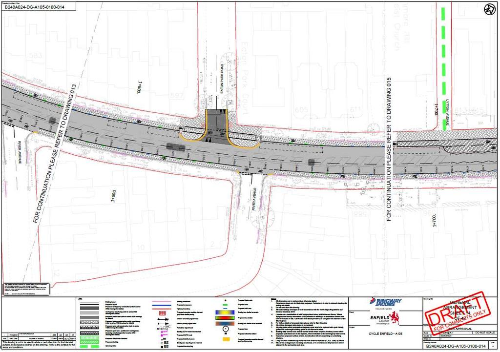
4 2.0 ITEMS RAISED IN PREVIOUS ROAD SAFETY AUDITS The proposals were subject to a Stage 1 Road Safety Audit carried out in March 2016 by TfL Road Safety Audit, Asset Management Directorate (Ref 2524/032/A105/BOR/2016). This report covered the whole route and therefore many of the issues raised are not specific to this (Section 6) part of the proposals. Items raised in the previous Audit Report deemed relevant to this section can be summarised as follows: Problem Problem Problem Problem Problem Combined zebra / cycle crossing facilities Proposed zebra and cycle crossing layouts may result in drivers failing to give way to cyclists. This problem remains in the detailed design proposals and is therefore raised again within this report as problem Cycle lanes past junction locations - Segregated cycle lanes terminating just before side road junctions may increase left turning collisions between vehicles and cyclists. This problem remains in the detailed design proposals and is therefore raised again within this report as problem Side road cycle crossovers at raised junction tables - Drivers turning from main roads to side roads may brake late due to cyclists crossing side roads, leading to nose to tail collisions, or cycle to vehicle conflict. This problem remains in the detailed design proposals and is therefore raised again within this report as problem Bus stops / loading bays close to side road junctions and accesses may restrict visibility splays and lead to failure to give way type collisions. This problem remains in the detailed design proposals and is therefore raised again within this report as part of problem Zebra crossing outside Sainsburys Proximity of bus stops to the zebra crossing reduces forward visibility and may lead to failure to give way type collisions involving cyclists. This problem remains in the detailed design proposals and therefore this is raised again as problem in this Audit Report. Items raised in the Stage 1 Road Safety Audit report that are outside the Terms of Reference: Issue 4.1 Issue 4.2 The revised kerb lines at side roads may alter vehicle swept paths and it is not clear if these have been assessed or may result in conflicts between turning vehicles. This issue is considered to remain in part and will therefore be raised again as part of problem in this Audit report. Bus boarders separated from the footways by cycle lanes may result in difficulties for some users to access the bus stop and may lead to low level cycle / pedestrian conflicts. Date: 11/01/ Version: A
5 Issue 4.11 Issue 4.12 This issue is considered to remain in part and will therefore be raised again as part of problem in this Audit report. South of Eaton Park Road Removal of this pedestrian refuge island may result in pedestrians crossing close to the parking bays or bus stops. This issue is considered to remain in part and will therefore be raised again as part of problem in this Audit report. Zebra crossing south of Stonard Road High vehicle speeds may be incompatible with the proposed zebra crossing. This issue is considered to remain in part and will therefore be raised again as part of problem in this Audit report. Date: 11/01/ Version: A
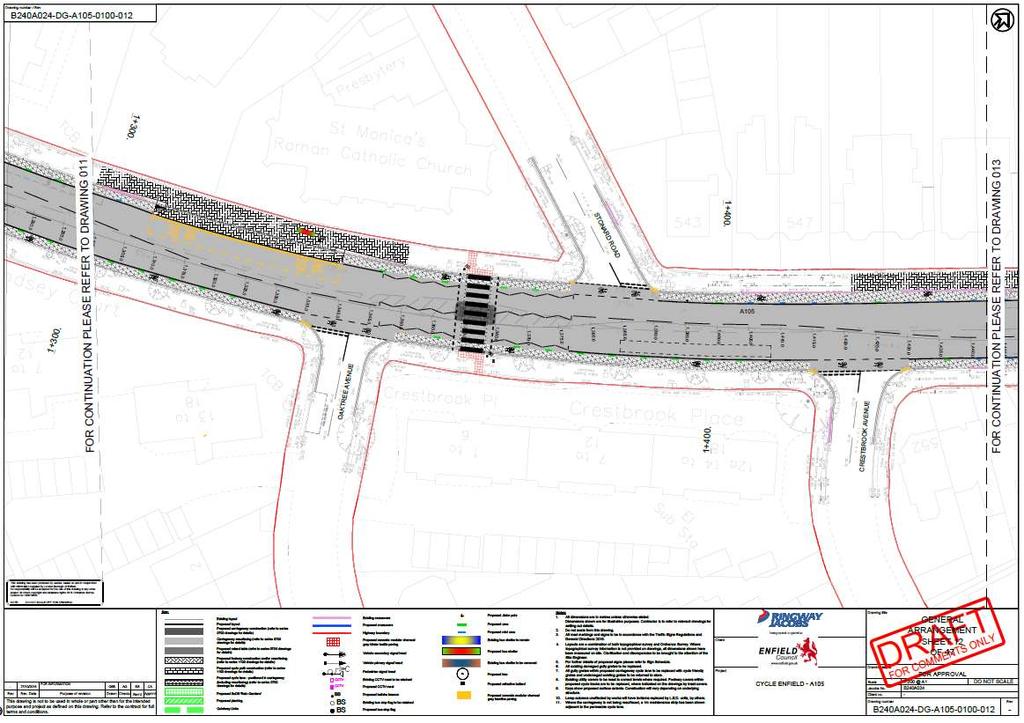
6 3.0 ITEMS RAISED AT THIS STAGE 2 ROAD SAFETY AUDIT This section should be read in conjunction with Paragraphs 1.2.1, and of this report. 3.1 CYCLING FACILITIES PROBLEM Location: Summary: General to scheme, multiple locations The use of Orcas as a segregation measure may lead to trips / falls for cyclists and pedestrians The proposals include Orcas as a semi / soft segregation measure alongside the cycle tracks. The Audit Team are concerned that the Orcas may not be adequately visible to road users, particularly pedestrians, cyclists and powered-two-wheelers. Pedestrians crossing the carriageway may fail to appreciate the raised nature of the Orcas, with a potential for trips and falls within the carriageway. Riders of two wheeled vehicles may fail to appreciate that the Orcas are raised, particularly in inclement weather. Riders may become destabilised as they over-run the features, leading to an increased potential to become unseated, with a resultant potential for personal injury. The potential for injury is exacerbated as the features are situated in positions where they are encouraged to be traversed, such as outside residential accesses. RECOMMENDATION It is recommended that any potential trip hazards are removed; this may require the use of an alternative type of segregation measure. Design Organisation Response Accepted / Part Accepted / Rejected The use of light segregation Orcas has been a proposed element of the scheme since initial development. The Orcas will be set inside the mandatory cycle lane marking (diag 1049B) and are white/black marked to stand out. In addition, the start and finish of an Orca line will be marked by a wand to further highlight the Orca line as it is approached. Orcas placed alongside vehicular access will be of a lower profile to allow vehicular over run. Orcas will be sited away from pedestrian crossing points to minimise the risk of trips. Post construction monitoring is recommended at a number of agreed locations to determine if there are any issues and to allow for modifications if necessary. Designer s response accepted post implementation monitoring will be carried out. Date: 11/01/ Version: A
7 3.1.2 PROBLEM Location: Summary: General to scheme, multiple locations Semi segregated cycle lanes terminating just before the side road junction may increase left turning collisions between vehicles and cyclists The proposed semi segregated cycle lanes return to the general carriageway just before various side road junctions. It may be difficult for both sets of road users to understand who has priority and this may lead to turning collisions involving cyclists. Cyclists may not anticipate and vehicles turning across their path in close proximity to them leaving the semi segregated cycle lane, which could lead to increased risk of side impact collisions as motorists cross the path of cyclists. RECOMMENDATION It is recommended that the priority is clearly defined. Furthermore, research from TRL (PPR703 Trials of segregation set-back at side roads) indicates that setting back cycle lanes by at least 20m from side roads may improve cyclist safety at junctions. Design Organisation Response Accepted / Part Accepted / Rejected Many of the side roads are tight residential streets. Therefore vehicles should be travelling at low speeds whilst turning into the side roads. The majority have been redesigned as Tables which should further reduce vehicular speed and reaction/assessment time. Cycle symbols have been provided on the carriageway across the mouths of the junctions to help warn motorists of the presence of cyclists. Designer s response accepted Date: 11/01/ Version: A
8 3.1.3 PROBLEM Location: Summary: General to scheme, multiple locations Bus passengers boarding or alighting may result in collisions with cyclists on the track The Audit Team are concerned that proposed cycle tracks run immediately adjacent to proposed bus stop boarders. Therefore bus passengers would board / alight a bus from / onto the cycle tracks. This may result in cyclists diverting away from the cycle track whilst their path is obscured, which may result in increased collisions with pedestrians or vehicles who may not expect cyclists diverting from the track. In addition, bus passengers alighting may not anticipate or be able to see approaching cyclists immediately adjacent to the bus, which may result in cycle to pedestrian type collisions. Visually impaired pedestrians, particularly those alighting from a bus may follow the kerb line and inadvertently enter the carriageway. Visually impaired pedestrian unknowingly within the carriageway are at an increased potential for collisions with motorists. RECOMMENDATION It is recommended that the layouts of the bus stop boarders / cycle tracks are altered to mitigate the potential interactions with bus passengers. This may include, but is not limited to, providing tramline tactile paving prior to the ramps down to carriageway level and an increased separation between the boarding / alighting area and the cycle track. Design Organisation Response Accepted / Part Accepted / Rejected Bus boarders have been introduced with a 0.5m buffer at locations where there is not scope to introduce a bus stop by-pass, to deliver an acceptable level of route continuity particularly at conflict points such as bus stops, where buses will be pulling into the kerb, through the desire line of a cyclist. The proposed bus stop boarders will use different material/tones to clearly show a change in environment from a segregated facility to a shared space. This is not dissimilar to a shared space environment adjacent to a toucan crossing, where pedestrian and cycles mix. Monitoring can be undertaken post-implementation to review the safe operation of the proposed design. Designer s response accepted operation of the bus stop boarders will be monitored post-implementation. Date: 11/01/ Version: A
9 3.1.4 PROBLEM Location: Summary: General to the scheme side road cycle crossovers at raised junction tables Drivers turning from main roads to side roads may brake late due to cyclists crossing side roads, leading to nose to tail collisions, or cycle / vehicle conflicts The off-road cycle facilities cross this side road at a raised table area, drivers turning from the main road have a short stacking space between the main road and these cycle crossovers. No give way markings are present as vehicles enter Sherbrook Gardens, neither is there sufficient stacking space to accommodate a vehicle without it overhanging on to the main road. Therefore, drivers may be confused by the arrangement and / or reluctant to give way to cyclists as it results in them remaining partially within the main carriageway, which may lead to late braking nose to tail collisions. The potential for conflicts may be exacerbated by the proposed parking relatively close to the side road between the main carriageway and segregated cycle track. Drivers entering the main road may be confused by the lack of give way markings and therefore an unclear priority. As a result motorists may fail to give way to traffic on the main road or stop across the cycle lane, which may lead to nose to tail collisions or cycle to vehicle conflict. RECOMMENDATION If such cycle priority is to be provided at side roads then this should be clearly designated, an appropriate stacking space should be provided between the main road and cycle crossing to allow vehicles to wait between the main road and cycle crossing without encroaching in to the main carriageway or blocking the cycle crossing (reference London Cycle Design Guide). Any floating loading / parking bays should be located to ensure that sufficient intervisibility is provided between cyclists and motorists. Additionally, it may be beneficial to provide additional give way markings consistently as vehicles enter the main road. Design Organisation Response Accepted / Part Accepted / Rejected The reference to Sherbrook Gardens is unclear as this is in Section 10 of the route. Give way markings have been provided at the exit from all side roads, being placed behind the cycle lanes crossing the side roads. Along the route, we have looked to provide stacking space for motor vehicles turning into side roads, wherever possible. However, providing suitable stacking space is often limited by road space constraints and the need to provide suitable space for pedestrians. Designer s response accepted. Date: 11/01/ Version: A
10 3.1.5 PROBLEM Location: Summary: General various footway level sections of cycle track Potential lack of delineation may lead to collisions with visually impaired pedestrians The Audit Team are concerned that the proposed measures do not appear to indicate a delineator between the footway and cycle tracks proposed at footway level. This could lead to visually impaired pedestrians inadvertently entering these sections of cycle lanes or potentially entering the carriageway via the ramp between the two facilities. Cyclists on the cycle track or motorists on the carriageway are unlikely to anticipate a visually impaired pedestrian and this may therefore result in increased collisions between these users. RECOMMENDATION It is recommended that as well as a good visual differentiation between the footway and cycle tracks, a detectable delineator should be provided to ensure that all users are aware of the edge of footway whilst not presenting a trip hazard. Design Organisation Response Accepted / Part Accepted / Rejected The cycle lane edging will comprise of 3 x 100x100mm cropped silver grey setts. The texture and differing contrast will indicate to visually impaired pedestrians that they should not enter the cycle lane. The cycle track will be surfaced in a suitable colour, to provide tonal difference with the surrounding footway. Designer s response accepted. Date: 11/01/ Version: A
11 3.1.7 PROBLEM Location: Summary: General Parking permitted adjacent to cycle track Parking / loading permitted adjacent to the cycle track may result in users exiting or unloading within the cycle track The proposals include retention of existing parking bays There appears to be a buffer of approximately 0.5m between the parking bays and the proposed cycle track. The Audit Team are concerned that pedestrians, users unloading and disabled users entering / exiting these vehicles, may do so within the cycle track which may result in an increased potential for collisions between southbound cyclists and people using / loading to / from the parking bays. RECOMMENDATION It is recommended that the buffer is increased to ensure that the cycle path is kept as clear as possible and suitable pedestrian and disabled user access to the parking bays is provided over the cycle track. Design Organisation Response Accepted / Part Accepted / Rejected Due to site constraints a minimum of 0.5m buffer has been provided throughout the scheme between the edge of cycle lane and the carriageway/parking or loading bays. This is considered wide enough to allow for opening doors and people to disembark from vehicles without causing an obstruction to the cycle lane. On occasions where passengers are unloading vehicles, visibility ahead is good and cyclists will be given enough time to check speed and warn of approach, if necessary. Designer s response accepted PROBLEM Location: Summary: Various commencements of full height kerbs Motorists may not notice and collide with the commencement of full height kerbs The Audit Team are concerned that motorists may not appreciate that the edge of the cycle track includes a full height kerb alongside the floating bus stop facility. This kerbed physical segregation commences within the carriageway running lane and it does not include a suitable vertical feature to highlight its presence or guide users alongside it. It may therefore, not be clear or conspicuous particularly during the hours of darkness. Motorists may collide with the kerb or swerve to avoid the features if they are noticed within close proximity, which may result in loss of control type collisions / injury to those on or within the vehicle. RECOMMENDATION It is recommended to alter the layout to suitably guide vehicles alongside the kerbs. This may include but is not limited to providing a vertical illuminated feature such as an Illuminated Guide Post (IGP) to provide suitable guidance alongside the feature. Design Organisation Response Accepted / Part Accepted / Rejected Throughout the scheme there will be mandatory cycle lane marking (diag 1049B) 150mm width which will indicate to vehicles the edge of carriageway. On the Date: 11/01/ Version: A
12 approach to the kerbed segregation island this road marking will be splayed out so that it is offset 150mm from the edge of the kerb. Designer s response accepted. The need for further measures to increase conspicuity of the kerbing will be reviewed post-implementation. Date: 11/01/ Version: A
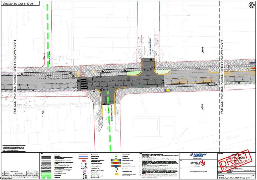
13 3.2 CROSSING FACILITIES PROBLEM Location: Summary: A South of junction with Barrowell Green Proposed parallel zebra and cycle crossing may result in drivers failing to give way to cyclists The Audit Team are concerned that the proposed parallel zebra and cycle crossing may not be understood by motorists particularly as the layout is new to drivers. The following issues may result in an increased potential for collisions: Zebra crossings are well established and the conspicuousness of the thick black and white striped road markings help to clearly indicate that a pedestrian has priority over vehicular traffic in this area. The lack of these markings within the proposed cycle section of the crossing may lead to ambiguity over who has priority and motorists may fail to give way to cyclists it is also noted that no cycle road marking logos are proposed. Slow approach speeds by pedestrians enable an approaching motorist to notice they intend to cross, slow down and stop. Cyclists are likely to approach faster than pedestrians and may therefore fail to be noticed by approaching motorists. Motorists turning left out of Barrowell Green encounter the cycle element of the crossing immediately as they enter the A105 Green Lanes, they may not appreciate or expect to encounter a crossing in such close proximity, particularly as this element of the crossing is less conspicuous. The routes / dropped kerb facilities intended for cyclists to enter the cycle element of the crossing from the cycle track / carriageway are not clearly defined. This may result in cyclists using undetermined and inconsistent routes which may result in increased collisions with pedestrians. These issues may lead to an increased potential for collisions between motorists and cyclists or shunt type collisions as motorists brake hard as they unexpectedly encounter a cyclist attempting to assert priority. It is also noted that the cycle part of the proposed crossing does not include cycle symbol road markings as prescribed in TSRGD RECOMMENDATION Provide measures which will allow cyclists to assert priority over motorists. This could include an alternative crossing type, or provide appropriate temporary signing etc to inform drivers of the intended usage until this layout becomes more commonplace. It may also be beneficial to relocate the crossing further away from the side roads and ensure the crossing complies with TSRGD 2016 which includes cycle symbols and to. Design Organisation Response Accepted / Part Accepted / Rejected The exit radius has been reduced in order to slow vehicles existing Barrowell Green. Moving it further south would bring the pedestrian element of the crossing closer to the parking bay on the northbound carriageway. This may lead to exiting driver s attention being drawn to northbound approaching vehicles, rather than the zebra crossing. Date: 11/01/ Version: A
14 Designer s response accepted. Date: 11/01/ Version: A
15 3.2.2 PROBLEM Location: Summary: B South of junction with Barrowell Green Proposed parallel zebra and cycle crossing may result in collisions between pedestrians and cyclists The Audit Team are concerned that the proposed parallel zebra and cycle crossing layout may result in pedestrians unexpectedly encountering a cyclist crossing their path. Examples include on the western side of the crossing, cyclists continuing southbound are effectively guided straight across the area where pedestrians exit the carriageway. Also, users travelling north or southbound on the eastern footway may not anticipate cyclists crossing their path as they attempt to enter the cycle crossing. Additionally, as the shared use extents on the eastern side of the crossing do not appear to be defined and as cyclists may make various / inconsistent manoeuvres to enter / exit the footway this may be difficult for pedestrians to anticipate which may further add to the potential for collisions between cyclists and pedestrians. RECOMMENDATION It is recommended to clarify the intended routes for cyclists and provide features to make these clear to both users, it may also be beneficial to clearly define the extents of the shared use area. This may require but is not limited to cycle logo markings to highlight the potential presence and intended route for cyclists and tactile paving / low level signs to indicate the extents of the shared use area on the eastern side of the crossing. Design Organisation Response Accepted / Part Accepted / Rejected On the western side the southbound section of cycle track is intended to connect up to a Quiet Way. Cycle volume is not expected to be as high as for the a105 route. Similar applies to the eastern side. The extents of shared areas have been defined and low level shared area signage will be provided Designer s response accepted. Date: 11/01/ Version: A
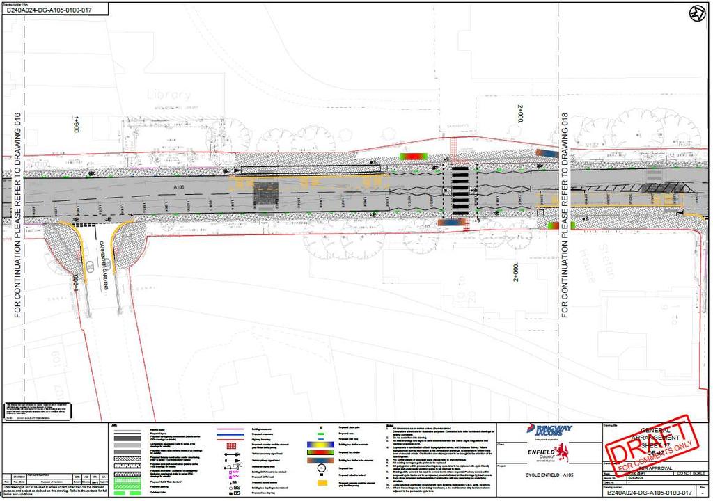
16 3.2.3 PROBLEM Location: Summary: C - Zebra crossing outside Sainburys Proximity of bus stops to the zebra crossing reduces forward visibility and may lead to failure to give way type collisions involving cyclists Bus stops on both sides of the crossing are located upstream of the zebra crossing location. When buses occupy the stops there may be poor forward visibility to the pedestrian waiting areas of the crossing for approaching drivers. Poor visibility may lead to drivers failing to stop at the crossing when a pedestrian is crossing, with consequent risk of pedestrian injury. RECOMMENDATION It is recommended that alterations are incorporated to ensure that adequate forward visibility should be provided to the pedestrian waiting areas on the approach to the crossing. This could be achieved by relocating the bus stops to a tail to tail orientation. Design Organisation Response Accepted / Part Accepted / Rejected The suggested tail to tail layout was considered either side of the crossing. However, the concern was that this would result in traffic regularly blocking back over the zebra crossings. A review of the bus stops has shown that the vast majority of passengers boarding and alighting at the two existing bus stops are travelling to/from the Sainsbury s store and therefore relocating the bus stops away from the supermarket was not considered satisfactory and tail to tail bus stops would result in the crossing being away from pedestrian desire lines, increasing the potential for informal crossing. Therefore it is felt that the proposed design represents the optimum layout for the location. The potential number of vehicles overtaking buses at speed is considered to be low. Designer s response accepted. Operation of crossing will be monitored post implementation and other measures, such as warning signage could be installed if necessary. Date: 11/01/ Version: A
17 3.2.4 PROBLEM Location: Summary: D A105 Green Lanes near junction with Eaton Park Road Removal of this crossing facility may result in pedestrians crossing at undetermined locations and an increased risk of potential collisions with motorists The Audit Team are concerned that an existing pedestrian desire-line appears to exist at this informal crossing point. As the existing pedestrian refuge island and dropped kerbs are proposed to be removed as part of the scheme proposals users may cross around this area but at undetermined locations such as beside the proposed parking bays, where they may have reduced intervisibility between approaching vehicles. Additionally, the lack of dropped kerbs may result in some users such as those with pushchairs or wheelchairs potentially having difficulties and taking longer to exit the carriageway. Therefore if pedestrians continue to cross at this location they may be at an increased risk of collisions with vehicles. Also pedestrians rushing to cross may be less likely to notice the orcas which may exacerbate the potential for trips and falls highlighted in RECOMMENDATION It is recommended to determine the pedestrian desire-lines and ensure that they are suitably catered for. This may include, but is not limited to providing additional crossing facilities. Design Organisation Response Accepted / Part Accepted / Rejected A pedestrian refuge island could not be accommodated in the proposed design, whilst retaining acceptable carriageway widths of minimum 3.25m in each direction, the existing two on-street parking spaces (to satisfy local residents) and the proposed cycle lanes. The distance between the retained zebra crossing south of Barrowell Green and the proposed crossing outside St Monica s church is approximately 350m, which is considered a reasonable spacing along a residential corridor. Reduced carriageway widths are anticipated to reduce vehicles speeds, increasing the safety for informal crossing. Designer s response accepted. Date: 11/01/ Version: A
18 3.2.5 PROBLEM Location: Summary: E A105 Green Lanes near junction with Stonard Road Proposed zebra crossing facility may not be compatible with vehicle speeds, which may result in collisions with pedestrians The Audit Team are concerned that the existing speeds along this section appear as though they may be higher than the recommended maximum 35mph (LTN 1/95). If the 85 th percentile speeds do exceed this then installation of a zebra crossing could lead to pedestrians being less likely to be able to assert priority over oncoming vehicles and / or for vehicles to not stop in time as a pedestrian tries to assert priority. This may therefore result in an increased potential for collisions with pedestrians, particularly whilst the bus stop (northeast bound approach) or parking bays (southwest bound approach) are not occupied, as these may have a traffic calming effect and reduce vehicle speeds on approach. RECOMMENDATION It is recommended to provide features to ensure that the approach speeds are suitable for the crossing type proposed. This may include, but is not limited to, providing more formalised / permanent speed reduction measures on approach to the crossing facility such as kerb build outs for the bus stop / parking bays. Design Organisation Response Accepted / Part Accepted / Rejected The approaches from both sides have been narrowed by the introduction of semisegregated cycle lanes. Speed monitoring could take place post installation to assess the 85% speed and, if necessary, introduce additional features. Designer s response accepted speed surveys will be undertaken postimplementation to determine approach speeds. Date: 11/01/ Version: A
19 3.3 JUNCTIONS PROBLEM Location: Summary: General to scheme, multiple locations The altered kerb lines may result in increased collisions as turning vehicles increasingly encroach into the path of another user The proposals include various kerb line alterations which may increase the potential for turning vehicles to encroach into another user s path. This could lead to an increased potential for head on or side impact type collisions as a user turning into or out of the side roads or accesses is encountered by a vehicle travelling in the opposing direction. RECOMMENDATION It is recommended to undertake / check swept path analysis and make alterations if necessary to ensure that the vehicles likely to use these roads can undertake typical manoeuvres with minimal intrusion into the path of another vehicle. Design Organisation Response Swept paths have been checked. Designer s response accepted. Accepted / Part Accepted / Rejected PROBLEM Location: Summary: General to the scheme bus stops / loading / parking bays close to side roads Stationary vehicles close to side road junctions and accesses may restrict junction visibility splays and lead to failure to give way type collisions At many locations the loading / parking bays are located close to side road junctions and accesses. Stationary vehicles close to side roads may restrict visibility for drivers emerging from the side roads and this may lead to failure to give way type collisions. Similarly, where bus stops are located close to the side roads the Audit Team are concerned that vehicles overtaking waiting buses may not suitably observe vehicles egressing from side roads which may result in side impact type collisions. RECOMMENDATION It is recommended to ensure that appropriate visibility splays at side roads should be provided and kept free of obstruction and stationary vehicles. This may require alterations to the positioning and / or extent of the bus stops / parking / loading bays. Design Organisation Response Accepted / Part Accepted / Rejected In terms of bus stops close to side roads, these bus stops generally take up the full width of the running lane (due to carriageway widening to accommodate the cycle facilities). In these circumstances it is considered unlikely that following vehicles will look to overtake the full length of a stationary bus. Designers response accepted. Date: 11/01/ Version: A
20 End of list of problems identified and recommendations offered in this Stage 2 Road Safety Audit Date: 11/01/ Version: A
21 4.0 ISSUES IDENTIFIED DURING THE STAGE 2 ROAD SAFETY AUDIT THAT ARE OUTSIDE THE TERMS OF REFERENCE Safety issues identified during the audit and site inspection that are considered to be outside the Terms of Reference, but which the Audit Team wishes to draw to the attention of the Client Organisation, are set out in this section. It is to be understood that, in raising these issues, the Audit Team in no way warrants that a full review of the highway environment has been undertaken beyond that necessary to undertake the Audit as commissioned. 4.1 ISSUE Location: Various junctions with proposed raised tables Reason considered to be outside the Terms of Reference: Issue for clarification rather than a defined road safety concern. Various junctions are proposed to have raised tables implemented. The kerb details indicate that away from crossing points where transition or flush kerbs are proposed the kerbs will have an upstand of 125mm or to match existing. It is not clear therefore what the upstand will be at the raised tables. It is assumed that a detectable upstand will be provided away from pedestrian crossing points. 4.2 ISSUE Design Organisation Response Upstand on tables will be 25mm away from crossing points. Designer s response accepted Location: Various shared use cycle / footway Accepted / Part Accepted / Rejected Reason considered to be outside the Terms of Reference: Issue for clarification rather than a defined road safety concern. It is not clear what the extents of the shared use surfaces are as none of the shared use extents appear to be defined. Additionally, at some locations it is not clear what the intended cyclist route is. In order to avoid cyclists continuing on the footway and the potential for low level cycle / pedestrian conflicts / unexpected cycle manoeuvres, it may be beneficial to clearly determine what the intended cycle routes are. This may include but is not limited to appropriate tactile paving, dropped kerbs and road markings / signs to indicate the intended routes / manoeuvres. Design Organisation Response Accepted / Part Accepted / Rejected Shared areas will be identified by appropriate signage and the change from specific cycle track surfacing (buff asphalt) to generic footway surfacing (paving slabs). Date: 11/01/ Version: A
22 4.3 ISSUE Designer s response accepted Location: Various throughout this section Reason considered to be outside the Terms of Reference: Issue for clarification rather than a defined road safety concern. Planting / SuDs Rain Gardens are proposed immediately adjacent to the carriageway / cycle lanes at various junctions throughout this section. The full details of the proposed features have not been provided but it is assumed that these will be of a type / maintained so that they do not restrict visibility or overgrow into the live carriageway areas. Design Organisation Response Confirmed. Designer s response accepted Accepted / Part Accepted / Rejected Date: 11/01/ Version: A
23 5.0 SIGNATURES AND SIGN-OFF 5.1 AUDIT TEAM STATEMENT We certify that we have examined the drawings and documents listed in Appendix A. to this Safety Audit report. The Road Safety Audit has been carried out in accordance with TfL Procedure SQA-0170 dated May 2014, with the sole purpose of identifying any feature that could be removed or modified in order to improve the safety of the measures. The problems identified have been noted in this report together with associated suggestions for safety improvements that we recommend should be studied for implementation. No one on the Audit Team has been involved with the design of the measures. AUDIT TEAM LEADER: Name: Shane Martin MCIHT, MSoRSA Signed: Position: Principal Road Safety Auditor Date: 11/01/2017 Organisation: Transport for London, Road Safety Audit Asset Management Directorate Address: 4 th Floor Palestra, 197 Blackfriars Road, London, SE1 8NJ Contact: shane.martin@tfl.gov.uk ( ) AUDIT TEAM MEMBER: Name: Kevin Seymour B Sc, PG Dip TS, MCIHT, MSoRSA Signed: Position: Principal Road Safety Auditor Date: 11/01/2017 Organisation: Transport for London, Road Safety Audit Asset Management Directorate Address: 4 th Floor Palestra, 197 Blackfriars Road, London, SE1 8NJ Contact: kevinseymour@tfl.gov.uk ( ) Date: 11/01/ Version: A
24 5.2 DESIGN TEAM STATEMENT In accordance with SQA-0170 dated May 2014, I certify that I have reviewed the items raised in this Stage 2 Safety Audit report. I have given due consideration to each issue raised and have stated my proposed course of action for each in this report. I seek the Client Organisation s endorsement of my proposals. Name: Colin Aarons Position: Project Manager Organisation: Jacobs Signed: Colin Aarons Dated: CLIENT ORGANISATION STATEMENT I accept these proposals by the Design Organisation. Name: David Taylor Position: Head of Traffic & Transportation Organisation: LB Enfield Signed: Dated: SECONDARY CLIENT ORGANISATION STATEMENT (where appropriate) I accept these proposals by the Design Organisation. Name: Position: Organisation: Signed: Dated: Date: 11/01/ Version: A
25 APPENDIX A Documents Forming the Audit Brief DRAWING NUMBER B240A024-DG-A Rev - B240A024-DG-A Rev - B240A024-DG-A Rev - B240A024-DG-A Rev - B240A024-DG-A Rev - B240A024-DG-A Rev - B240A024-DG-A Rev - B240A024-DG-A Rev - B240A024-DG-A Rev - B240A024-DG-A Rev - B240A024-DG-A Rev - B240A024-DG-A Rev - DRAWING TITLE Cycle Enfield A105 - General Arrangement Sheet 12 of 47 Cycle Enfield A105 - General Arrangement Sheet 13 of 47 Cycle Enfield A105 - General Arrangement Sheet 14 of 47 Cycle Enfield A105 - General Arrangement Sheet 15 of 47 Cycle Enfield A105 - General Arrangement Sheet 16 of 47 Cycle Enfield A105 - General Arrangement Sheet 17 of 47 Cycle Enfield A105 - Site Clearance Sheet 12 of 47 Cycle Enfield A105 - Site Clearance Sheet 13 of 47 Cycle Enfield A105 - Site Clearance Sheet 14 of 47 Cycle Enfield A105 - Site Clearance Sheet 15 of 47 Cycle Enfield A105 - Site Clearance Sheet 16 of 47 Cycle Enfield A105 - Site Clearance Sheet 17 of 47 B240A024-DG-A Rev A B240A024-DG-A Rev A B240A024-DG-A Rev A B240A024-DG-A Rev A B240A024-DG-A Rev A B240A024-DG-A Rev A Cycle Enfield A105- Proposed drainage plan Sheet 12 of 47 Cycle Enfield A105- Proposed drainage plan Sheet 13 of 47 Cycle Enfield A105- Proposed drainage plan Sheet 14 of 47 Cycle Enfield A105- Proposed drainage plan Sheet 15 of 47 Cycle Enfield A105- Proposed drainage plan Sheet 16 of 47 Cycle Enfield A105- Proposed drainage plan Sheet 17 of 47 Date: 11/01/ Version: A
26 B240A024-DG-A Rev - B240A024-DG-A Rev - B240A024-DG-A Rev - B240A024-DG-A Rev - B240A024-DG-A Rev B240A024-DG-A Rev - B240A024-DG-A Rev - B240A024-DG-A Rev - B240A024-DG-A Rev - B240A024-DG-A Rev - B240A024-DG-A Rev B240A024-DG-A Rev - B240A024-DG-A Rev B B240A024-DG-A Rev B B240A024-DG-A Rev B B240A024-DG-A Rev B B240A024-DG-A Rev B B240A024-DG-A Rev B Cycle Enfield A105 Road Pavements General Sheet 12 of 47 Cycle Enfield A105 Road Pavements General Sheet 13 of 47 Cycle Enfield A105 Road Pavements General Sheet 14 of 47 Cycle Enfield A105 Road Pavements General Sheet 15 of 47 Cycle Enfield A105 Road Pavements General Sheet 16 of 47 Cycle Enfield A105 Road Pavements General Sheet 17 of 47 Cycle Enfield A105 - Kerbs footways and paved areas Sheet 12 of 47 Cycle Enfield A105 - Kerbs footways and paved areas Sheet 13 of 47 Cycle Enfield A105 - Kerbs footways and paved areas Sheet 14 of 47 Cycle Enfield A105 - Kerbs footways and paved areas Sheet 15 of 47 Cycle Enfield A105 - Kerbs footways and paved areas Sheet 16 of 47 Cycle Enfield A105 - Kerbs footways and paved areas Sheet 17 of 47 Cycle Enfield A105 - Traffic signs and road markings Sheet 12 of 47 Cycle Enfield A105 - Traffic signs and road markings Sheet 13 of 47 Cycle Enfield A105 - Traffic signs and road markings Sheet 14 of 47 Cycle Enfield A105 - Traffic signs and road markings Sheet 15 of 47 Cycle Enfield A105 - Traffic signs and road markings Sheet 16 of 47 Cycle Enfield A105 - Traffic signs and road markings Sheet 17 of 47 Date: 11/01/ Version: A
27 B240A024-DG-A Rev A B240A024-DG-A Rev A B240A024-DG-A Rev A B240A024-DG-A Rev A B240A024-DG-A Rev A B240A024-DG-A Rev A Cycle Enfield A105 MCHW Series 1300 Road Lighting Column & Bracket Mainline Layout Plan Sheet 12 of 47 Cycle Enfield A105 MCHW Series 1300 Road Lighting Column & Bracket Mainline Layout Plan Sheet 13 of 47 Cycle Enfield A105 MCHW Series 1300 Road Lighting Column & Bracket Mainline Layout Plan Sheet 14 of 47 Cycle Enfield A105 MCHW Series 1300 Road Lighting Column & Bracket Mainline Layout Plan Sheet 15 of 47 Cycle Enfield A105 MCHW Series 1300 Road Lighting Column & Bracket Mainline Layout Plan Sheet 16 of 47 Cycle Enfield A105 MCHW Series 1300 Road Lighting Column & Bracket Mainline Layout Plan Sheet 17 of 47 DOCUMENTS Safety Audit Brief Site Location Plan Traffic signal details TfL signal safety checklist Departures from standard Previous Road Safety Audits Previous Designer Responses Collision data Collision plot Traffic flow / modelling data Pedestrian flow / modelling data Speed survey data Other documents DETAILS (where appropriate) 2524/032/A105/BOR/2016 A105 Enfield - Proposed Road Marking Schedule A105 Enfield - Sign Schedule - Section 6 Date: 11/01/ Version: A
28 APPENDIX B Problem Locations Date: 11/01/ Version: A
29 E

30
31 D
32 B A

33
34 C
A105 Green Lanes junction with Bourne Hill / Hedge Lane
 Cycle Enfield - Section 5 A105 Green Lanes junction with Bourne Hill / Hedge Lane Stage 2 Road Safety Audit Ref: 2759.03.05/032/A105/BOR/2016 Prepared for: London Borough of Enfield By: Road Safety Audit,
A105 South of Ecclesbourne Gardens to Oakthorpe Road
 Cycle Enfield - Section 1 A105 South of Ecclesbourne Gardens to Oakthorpe Road Stage 2 Road Safety Audit Ref: 2759.03.01/032/A105/BOR/2016 Prepared for: London Borough of Enfield By: Road Safety Audit,
SLOUGH Stage 3 Road Safety Audit of A4 London Road, M4 J5 to Sutton Lane
 SLOUGH Stage 3 Road Safety Audit of A4 London Road, M4 J5 to Sutton Lane Exception Report Client Officer Rudo Beremauro Date 20 January 2015 RSA /Project Sponsor s Contents Section 3 Project Sponsor's
Design and Installation of Low Level Cycle Signals
 Transport for London Surface Transport Management System Document Guidance Note Design and Installation of Low Level Cycle Signals Document reference: SQA-0651 - Issue: Draft out of date information. 1
Rhebogue Neighbourhood Greenway. Road Safety Audit Stage 2
 Rhebogue Neighbourhood Greenway Road Safety Audit Stage 2 Report Number: 12/007/00/00057 July 2014 Mid West National Road Design Office Lissanalta House, Dooradoyle County Limerick Tel: 061 496 800 Fax:
Entry Treatments. Traffic Advisory Leaflet 2/94 August Introduction. Design. Vertical Deflections. Locations
 Traffic Advisory Leaflet 2/94 August 1994 Entry Treatments Introduction Entry treatments have been developed for use at side roads so that drivers leaving a major road are in no doubt that they are entering
DESIGN CODE. Enterprise West Harlow London Road North Design Code 21
 DESIGN CODE Enterprise West Essex @ Harlow London Road North Design Code 21 4 MAXIMUM BUILDING HEIGHTS 4.1 Table 4A sets out maximum building height standards for each character area within the LDO boundary.
Appendix 12 Parking on footways and verges
 Appendix 12 Parking on footways and verges Legal position Parking on footways and verges whether wholly or partly is banned throughout London, unless signs are placed to allow parking. The ban requires
Cabinet Member for Highways & Streetscene. Highway Infrastructure Manager
 LONDON BOROUGH OF RICHMOND UPON THAMES DATE: AUGUST 2015 DECISION MAKER: LEAD OFFICER: SUBJECT: WARDS: Cabinet Member for Highways & Streetscene Highway Infrastructure Manager PROPOSED CYCLING IMPROVEMENTS
Appendix F CAPITA Technical Audit
 Appendix F CAPITA Technical Audit West Hendon - Major Review of Technical Audit Responses 14 June 2016 Quality Management Quality Management Job No Project Location Title CS/086106 West Hendon - Major
Cyclists at road narrowings
 Traffic Advisory Leaflet 1/97 February 1997 Cyclists at road narrowings Introduction Traffic calmed streets can offer a more attractive environment for cycling, by reducing motor vehicles speeds to a level
LEA BRIDGE ROAD - A STREET FOR EVERYONE Public consultation document
 LEA BRIDGE ROAD - A STREET FOR EVERYONE Public consultation document TELL US Bakers Arms to Leyton Green Road (Section D, E, F) Leyton Green Road to Whipps Cross Roundabout (Section G) YOUR VIEWS www.enjoywalthamforest.co.uk
Guide to the Cycle Enfield Public Consultation on Enfield Town. Produced by the Save Our Enfield Town Campaign Group
 Guide to the Cycle Enfield Public Consultation on Enfield Town Produced by the Save Our Enfield Town Campaign Group What s in this guide? Introduction Page 3 What Enfield Council says about Option 1 Page
TRAFFIC CALMING GUIDE FOR TORONTO CITY OF TORONTO TRANSPORTATION SERVICES DIVISION
 TRAFFIC CALMING GUIDE FOR TORONTO CITY OF TORONTO TRANSPORTATION SERVICES DIVISION CITY OF TORONTO TRANSPORTATION SERVICES DIVISION 2016 TRAFFIC CALMING GUIDE FOR TORONTO TABLE OF CONTENTS Introduction
Issues at T junctions:
 TheSlade_PublicConsulationPlans_March2017.pdf These comments relate to junction designs in this phase of the project on The Slade. Comments begin with the northernmost junction: Girdlestone Rd and continue
Ulster Canal Greenway Phase 1 Stage 2 Road Safety Audit
 Monaghan County Council July 2013 Ulster Canal Greenway Phase 1 Stage 2 Road Safety Audit Prepared by:... Checked by:... Johanne Browne Brian McMahan Senior Consultant Senior Engineer Approved by:... Joe
CITY OF OTTAWA ROADWAY MODIFICATION APPROVAL UNDER DELEGATED AUTHORITY
 RMA-2015-ATM-038 CITY OF OTTAWA ROADWAY MODIFICATION APPROVAL UNDER DELEGATED AUTHORITY DATE: April 22, 2015 SUBJECT Approval of Roadway Modifications Recommended through an Area Traffic Management Study
Traffic calming regulations (Scotland)
") Traffic Advisory Leaflet 11/94 December 1994 Traffic calming regulations (Scotland) Introduction Traffic calming can help drivers to make their speeds appropriate to local conditions, through measures
Traffic Advisory Leaflet 11/94 December 1994 Traffic calming regulations (Scotland) Introduction Traffic calming can help drivers to make their speeds appropriate to local conditions, through measures
The existing site constraints which may be encountered for the A428 scheme proposals are divided into sections as follows.
 Project: A428 Study To: Cambridgeshire County Council Subject: Tidal Bus lane Review From: Atkins Date: 24 May 2016 cc: Introduction As part of the A428 Corridor Study to improve the bus journey time between
CHECKLIST 2: PRELIMINARY DESIGN STAGE AUDIT
 CHECKLIST 2: PRELIMINARY DESIGN STAGE AUDIT 2.1 General topics 2.1.1 Changes since previous audit Do the conditions for which the scheme was originally designed still apply? (for example, no changes to
Chicane Schemes. Traffic Advisory Leaflet 12/97 December Introduction
 Traffic Advisory Leaflet 12/97 December 1997 Chicane Schemes Introduction Traffic Advisory Leaflet 9/94 "Horizontal Deflections" reported on the results of track trials carried out by the Transport Research
Traffic Calming Regulations
 Traffic Advisory Leaflet 7/93 August 1993 Traffic Calming Regulations Introduction Traffic calming can help drivers to make their speeds appropriate to local conditions, through measures which are self-enforcing.
How do we design for pedestrians? Case study: transforming the Walworth Road
 How do we design for pedestrians? Case study: transforming the Walworth Road David Moores, Director of Public Realm Institution of Highways and Transportation, November 2009 Presentation overview Design
Appendix A Type of Traffic Calming Measures Engineering Solutions
 Appendix A Type of Traffic Calming Measures Engineering Solutions PHYSICAL MEASURES Central Hatching The major consideration of this feature is that, these markings can only be laid down the centre of
Parking. Signing. Appendix C Typical detail drawings. London Cycling Design Standards
 Appendix C Typical detail drawings London Cycling Design Standards All drawings are prefixed CCE/ General A1 Cycle Symbol Diagram 1057 165 A3 Raised entry treatment on side roads 166 A4 Raised table at
Active Transportation Facility Glossary
 Active Transportation Facility Glossary This document defines different active transportation facilities and suggests appropriate corridor types. Click on a facility type to jump to its definition. Bike
TS 109 DURHAM ROAD QTC PHASE 4 PROJECT PROPOSAL. Page 1
 TS 109 DURHAM ROAD QTC PHASE 4 PROJECT PROPOSAL Page 1 Table of Contents 1.0 Introduction... 3 2.0 Project Overview... 3 3.0 Project Proposals... 4 3.1 Enfield Road / Durham Road Junction... 3 5 3.2 Summerfield
PART 5 TD 51/03 SEGREGATED LEFT TURN LANES AND SUBSIDIARY DEFLECTION ISLANDS AT ROUNDABOUTS SUMMARY
 DESIGN MANUAL FOR ROADS AND BRIDGES VOLUME 6 SECTION 3 ROAD GEOMETRY HIGHWAY FEATURES PART 5 TD 51/03 SEGREGATED LEFT TURN LANES AND SUBSIDIARY DEFLECTION ISLANDS AT ROUNDABOUTS SUMMARY This document sets
Perne Rd / Radegund Rd Roundabout Cambridge
 Perne Rd / Radegund Rd Roundabout Cambridge The conversion of an conventional urban roundabout to continental geometry A little bit of history The first traffic roundabout was built in Sollershott, Letchworth
Appendix C. TRAFFIC CALMING PROGRAM TOOLBOX
 Appendix C. TRAFFIC CALMING PROGRAM TOOLBOX PHASE I...2 Do Not Enter Sign...3 One-Way Sign...4 Turn Prohibition...5 Pavement Markings...6 Speed Monitoring Trailer...7 Neighborhood Speed Watch...8 Police
Audit No. RSA Stage 1 Road Safety Audit Bermuda Park, Nuneaton Getting West Nuneaton Moving: Bermuda Connection
 Audit No. RSA 2199 Stage 1 Road Safety Audit Bermuda Park, Nuneaton Getting West Nuneaton Moving: Bermuda Connection 1 1.0 INTRODUCTION 1.1 This report results from a Stage 1 Road Safety Audit for a highways
The Cabinet Member for Highways & Streetscene. Aurang Zeb - Head of Highways & Transport
 LONDON BOROUGH OF RICHMOND UPON THAMES Cabinet Member Decision DATE: January 2012 REPORT OF: LEAD OFFICER: SUBJECT: WARDS: The Cabinet Member for Highways & Streetscene Aurang Zeb - Head of Highways &
Strategic Director for Environment. Enclosures Appendix A - Option drawings. Jamie Blake- Strategic Director for Environment
 Chipping Barnet Area Committee 9 July 2018 Title Report of Wards Status Urgent Key Cromer Road Request for 20mph Zone Strategic Director for Environment High Barnet Public No No Enclosures Appendix A -
PART 5 TD 51/17 SUMMARY
 DESIGN MANUAL FOR ROADS AND BRIDGES VOLUME 6 SECTION 3 ROAD GEOMETRY HIGHWAY FEATURES PART 5 TD 51/17 SEGREGATED LEFT TURN LANES AND SUBSIDIARY DEFLECTION ISLANDS AT ROUNDABOUTS SUMMARY This document sets
Frascati Road and Temple Hill Route Improvements. Outline Design Report to Accompany Public consultation
 Frascati Road and Temple Hill Route Improvements Outline Design Report to Accompany Public consultation September 2013 Background: Dún Laoghaire-Rathdown is committed to providing high quality pedestrian
DRAFT. Jesmond Vale Lane. Meldon Terrace. Heaton Road. King John Street. Newcastle City Council
 Remove footway build-out and reposition crossing equipment & tactile paving uild-out kerb to reduce turning speeds Jesmond Vale Lane Provide gap in parking for right turning cycles Light segregation set-back
London Cycling Design Standards. Chapter 4 Links Cycle lanes, cycle tracks and other cycle facilities
 London Cycling Design Standards 4 Chapter 4 Links Cycle lanes, cycle tracks and other cycle facilities Contents 4.1 Introduction and general issues 4.2 Cycle lanes (on-carriageway) 4.3 Bus lanes and other
Document 2 - City of Ottawa Pedestrian Crossover (PXO) Program
 Program") 40 Document 2 - City of Ottawa Pedestrian Crossover (PXO) Program OVERVIEW The City of Ottawa Pedestrian Crossover (PXO) Program provides the basis for PXO implementation in Ottawa. The program s processes
40 Document 2 - City of Ottawa Pedestrian Crossover (PXO) Program OVERVIEW The City of Ottawa Pedestrian Crossover (PXO) Program provides the basis for PXO implementation in Ottawa. The program s processes
Chapter 4 Route Window C3 Hyde Park and Park Lane shafts. Transport for London
 Chapter 4 Route Window C3 Hyde Park and Park Lane shafts Transport for London HYDE PARK AND PARK LANE SHAFTS 4 Route Window C3 Hyde Park and Park Lane shafts Introduction 4.1 In this route window, which
The Ins and Outs of Roundabouts
 The Ins and Outs of Roundabouts Safety Auditors Perspective April 2000 TABLE OF CONTENTS PAGE Preface 3 Introduction 4 Road Safety Audits 5 List of Common Road Safety Problems at Roundabouts 6 Commonly
MILTON ROAD LLF PROJECT UPDATE
 Greater Cambridge City Deal MILTON ROAD LLF PROJECT UPDATE 9 th May 2017 Project objectives Comprehensive priority for buses in both directions wherever practicable; Additional capacity for sustainable
TGSI Tactile Ground Surface Indicators
 TGSI Tactile Ground Surface Indicators Introduction: This Design Note, No 11, provides guidelines and requirements for the use and installation of Tactile Ground Surface Indicators (TGSI s). References
Highway Code for Cyclists Operation Close-Pass
 Highway Code for Cyclists Operation Close-Pass 1 2 Operation Close-Pass For the 2 million people who cycle every day, close passes are an almost daily occurrence. Close passes are really intimidating and
Transport Research Laboratory Creating the future of transport
 Transport Research Laboratory Creating the future of transport PUBLISHED PROJECT REPORT PPR730 Off-street trials of a Bus Stop Bypass An assessment of user perceptions, safety, capacity and accessibility
Milton Road Bus Stop and Crossings Workshop WSP. 19th September 2017
 Bus Stop and Crossings Workshop WSP 19th September 2017 Workshop Aims Task 1: Identify preferences for bus stop designs relative to: (a) Ranking preference between 4 possible bus stop designs on the narrower
Chapter 4 - Links Within the Highway. Suitability of Routes
 Chapter 4 - Links Within the Highway Suitability of Routes Most cycling takes place on existing urban roads; this will also be the case with the National Cycle Network. As well as following lightly trafficked
RAILWAY LEVEL CROSSING CHECKLIST Road Safety Review of Railway Crossings
 RAILWAY LEVEL CROSSING CHECKLIST Road Safety Review of Railway Crossings Location: Crossing No. Date of On-Site Inspection: (Day) / / (Night) / / Weather: CHECKLIST 5. - GENERAL TOPICS Level of control
M9/A90/M90 Edinburgh to Fraserburgh Trunk Road. A90 Tealing. Moving Cursor Programme Junction Study
 A90 Tealing Moving Cursor Programme Junction Study This is an unpublished report prepared for the Transport Scotland, Trunk Road and Bus Operations Division (TRBO) and must not be referred to in any publication
Derby Cycling Group, c/o 126, Station road, Mickleover, Derby, DE3 9FN. Date: 20 th November, 2018.
 Your Ref: Derby City Council Air Quality - Preferred Option Nov 2018 Derby Cycling Group, c/o 126, Station road, Mickleover, Derby, DE3 9FN Date: 20 th November, 2018. 1. Introduction: 1.1. Derby Cycling
CHECKLIST 5: ROADWORK TRAFFIC SCHEME AUDIT
 CHECKLIST 5: ROADWORK TRAFFIC SCHEME AUDIT 5.1 General items 5.1.1 Alignment Are the roadworks located safely with respect to horizontal and vertical alignment? If not, does works signing cater for this?
City of Seattle Edward B. Murray, Mayor
 City of Seattle Edward B. Murray, Mayor Department of Transportation Scott Kubly, Director Eastlake Community Council 117 E Louisa St. #1 Seattle, WA 98102-3278 January 28, 2016 RE: Roosevelt to Downtown
Dún Laoghaire Rathdown County Council. Luas to Dart via UCD Cycle and Pedestrian Route
 Dún Laoghaire Rathdown County Council Luas to Dart via UCD Cycle and Pedestrian Route October 2012 Luas to Dart via UCD Cycle and Pedestrian Route DOCUMENT CONTROL SHEET Client: Project Title: Document
Broad Street Bicycle Boulevard Design Guidelines
 Broad Street Bicycle Boulevard Design Guidelines Building from the strategies introduced in the 2013 Bicycle Transportation Plan and community input received thus far, City Transportation Staff have identified
Economic and Social Council
 UNITED NATIONS E Economic and Social Council Distr. GENERAL 20 December 2006 ENGLISH Original: ENGLISH and FRENCH ECONOMIC COMMISSION FOR EUROPE INLAND TRANSPORT COMMITTEE Working Party on Road Traffic
Low Level Cycle Signals used as repeaters of the main traffic signals Appendices
 Low Level Cycle Signals used as repeaters of the main traffic signals Appendices Track trial report This document contains the appendices to accompany the report from the first sub-trial of a larger track
EUCLID AVENUE PARKING STUDY CITY OF SYRACUSE, ONONDAGA COUNTY, NEW YORK
 EUCLID AVENUE PARKING STUDY CITY OF SYRACUSE, ONONDAGA COUNTY, NEW YORK CITY OF SYRACUSE DEPARTMENT OF PUBLIC WORKS 1200 CANAL STREET EXTENSION SYRACUSE, NEW YORK 13210 DRAFT REPORT DATE: November 13,
Chapter 7 - Rural Roads
 Chapter 7 - Rural Roads Rural Roads On a significant length of the National Cycle Network cyclists will share rural roads with other traffic. The objective is to incorporate into the National Cycle Network
REF. PE01595: MORATORIUM ON SHARED SPACE SCHEMES
 PE1595/RRR Sustrans submission of 17 March 2017 Following the Public Petitions Committee meeting on 9 th February 2017 you wrote to Sustrans Scotland requesting a clarification on our position on the use
IMPROVEMENT OPTIONS REPORT - WONERSH VILLAGE. for WONERSH PARISH COUNCIL. March V3.0 stilwell-ltd.co.uk
 IMPROVEMENT OPTIONS REPORT - WONERSH VILLAGE for WONERSH PARISH COUNCIL March 2016 V3.0 stilwell-ltd.co.uk Improvement Options Report Wonersh Village, Wonersh Date of Prepared Checked Revision Comments
CURBSIDE ACTIVITY DESIGN
 5 CURBSIDE ACTIVITY DESIGN This chapter provides design guidance for separated bike lanes adjacent to curbside activities including parking, loading and bus stops. Typical configurations are presented
Improving Cyclist Safety at the Dundas Street West and Sterling Road Intersection
 STAFF REPORT ACTION REQUIRED Improving Cyclist Safety at the Dundas Street West and Sterling Road Intersection Date: August 17, 2012 To: From: Wards: Reference Number: Public Works and Infrastructure Committee
West Midlands Cycle Design Guidance Cycling and the Midland Metro
 Transport for the West Midlands Cycling and the Midland Metro September 2017 Project Code: 02821 Phil Jones Associates Ltd Seven House High Street Longbridge Birmingham B31 2UQ philjonesassociates.co.uk
POLICY: TRAFFIC CALMING
 2006 MAY REFERENCE: COUNCIL APPROVED BY COUNCIL MAY 23, 2006 CITY OPERATIONS - NO. 608 POLICY: TRAFFIC CALMING A. All requests for traffic calming within the City shall be considered in accordance with
FAQ s Walsh Road / Ferguson Road Pilot Scheme
 FAQ s Walsh Road / Ferguson Road Pilot Scheme What is happening? Traffic calming measures are being installed as a pilot. Temporary Bollards will be installed to the east of 1 Ferguson Road and a Temporary
Chelmsford City Growth Package
 Chelmsford City Growth Package Public Consultation Document Volume 2 West Chelmsford July - August 2017 Chelmsford City Growth Package Public Consultation Document - Volume 2 - West Chelmsford Contents
Cuddington Traffic Calming
 Buckinghamshire County Council Cuddington Traffic Calming PRIV18003 / FEA / DOC / 01 June 2018 Ringway Jacobs Ltd Harling House 47-51 Great Suffolk Street London SE1 0BS Tel: 02079604040 Fax: 02079604051
Traffic Assets Section Proposed Removal of Street Lighting Road Safety Review Report No 48
 Street Lighting Section Unique Reference: o. 48 Traffic Assets Section Report o 48 Reviewer: Ellie Briggs, BEng (Hons) CEng MICE Highway Classification / umber Road / Street ame: District / Settlement:
Streets for All : 9 Use of white lines
 Streets for All : 9 Use of white lines On 1st April 2015 the Historic Buildings and Monuments Commission for England changed its common name from English Heritage to Historic England. We are now re-branding
Traffic Safety Plan Second Avenue
 Traffic Safety Plan Second Avenue April 2017 City of Greater Sudbury Roads & Transportation Services Division Overview Overview... 2 1.0 Project Overview... 4 2.0 Pedestrian Safety... 4 2.1 Current Infrastructure...
Essential Standard No. 16. Streetworks - Short duration static works carried out from a vehicle
 Key Messages Short duration static works must not exceed 60 mins, including setting up and dismantling traffic management. A vehicle or vehicles should be used whenever possible to protect the workforce.
Technical Director, Jacobs IHT Urban Design Panel. Challenge of MfS Acknowledgements visibility forward SSD side road SSD
 for Public Realm Schemes for Public Realm Schemes IHT London Branch evening meeting 30 September 009 Ken Huddart Kate Carpenter Technical Director, Jacobs IHT Urban Design Panel Kate Carpenter IHT Road
CITY OF WEST KELOWNA COUNCIL POLICY MANUAL
 CITY OF WEST KELOWNA COUNCIL POLICY MANUAL Page 1 of 7 DEPARTMENT: Engineering Services SUBJECT: Traffic Calming Policy (Revised June 6, 2017) Policy Statement: The provision of traffic calming measures
Stage 2 Road Safety Audit
 Consulting Stage 2 Road Safety Audit Stretford Public Realm Improvements Phase 1 CO00201045 June 2017 ISSUED Document Control Sheet Project Name: Stretford Public Realm Improvements Phase 1 Project Number:
MANUAL OF TRAFFIC SIGNS AND MARKINGS SECTION 2
 MANUAL OF TRAFFIC SIGNS AND MARKINGS PART 1 SIGNS SECTION 2 September 2015 VERSION 1.0 - DRAFT FOR REVIEW Part 1 Signs REGULATORY SIGNS GENERAL CONTENTS SECTION 2: REGULATORY SIGNS GENERAL (DESIGN, POLICY
Appendix D Stage 1 Road Safety Audit
 N2 Monaghan Town to Emyvale Road Improvements Part 8 Application Description of Proposed Development Appendi D N2 Monaghan Town to Emyvale, County Monaghan Proposed Pavement and Minor Improvement Scheme
Background. Caversham a vision for the future. Joint public meeting arranged by:
 Joint public meeting arranged by: Sharing our Streets Caversham a vision for the future and Caversham Traders Association This presentation followed a presentation by Simon Beasley, Network Manager for
Sevenways Roundabout, and the need for a Road Safety Scheme:
 Sevenways Roundabout, and the need for a Road Safety Scheme: The way the current roundabout has evolved has obviously created an environment that is dangerous for all road users, motorists, cyclists and
Traffic Control Inspection Checklist Segment:
 Traffic Control Inspection Checklist Segment: Simon Contractors Simon Contractors Originator: Description Reviewed by: Initials Date Distribution: Traffic Quality Manager, Site Assistant Traffic Manager
Side Roads and Other Non-Signalised Junctions
 Green Surfacing Sections of the Cycle Superhighway are marked with green paint these highlight sections where people cycling the Superhighway are likely to come into contact with walkers, drivers, or other
10 SHERFORD Town Code
 Key Fixes (Ref: Masterplan Book, section 4a. Land Use Budget and Key Fixes ) The Town Plan designs and allocates buildings, streets and spaces as accurately as possible in the understandable absence of
CHAPTER 2G. PREFERENTIAL AND MANAGED LANE SIGNS
 2011 Edition - Revision 2 Page 275 Section 2G.01 Scope CHAPTER 2G. PREFERENTIAL AND MANAGED LANE SIGNS 01 Preferential lanes are lanes designated for special traffic uses such as high-occupancy vehicles
CHECKLIST 6: EXISTING ROADS: ROAD SAFETY AUDIT
 CHECKLIST 6: EXISTING ROADS: ROAD SAFETY AUDIT 6.1 Road alignment and cross-section 6.1.1 Visibility; sight distance Is sight distance adequate for the speed of traffic using the route? Is adequate sight
CHAPTER 1 STANDARD PRACTICES
 CHAPTER 1 STANDARD PRACTICES OBJECTIVES 1) Functions and Limitations 2) Standardization of Application 3) Materials 4) Colors 5) Widths and Patterns of Longitudinal Pavement Marking Lines 6) General Principles
Bus and Transit Lane Review Update
 Board Meeting / 25 February 2013 Agenda Item no.8(i) Bus and Transit Lane Review Update Glossary Auckland Transport New Zealand Transport Agency Transit Two Transit Three (AT) (NZTA) (T2) (T3) Executive
Review of Guidelines for Cycleway Safety Fencing
 Review of Guidelines for Cycleway 1.0 PURPOSE 1.1 This document is meant to provide a review of available reference documents for determining appropriate fencing requirements for cycleway paths and shared
Local Highway Panels Members Guide. 5 Crossing Facilities
 Local Highway Panels Members Guide 5 2 Local Highway Panels (LHP) Members Guide 2016/17 1. Introduction On the Network where there are sufficient crossing opportunities most individuals are able to cross
Town of Mooresville, North Carolina Neighborhood Traffic Calming and Control Device Policy
 Town of Mooresville, North Carolina Neighborhood Traffic Calming and Control Device Policy Adopted January 6, 2014 Town of Mooresville Development Services Department TOWN OF MOORESVILLE NEIGHBORHOOD TRAFFIC
CHECKLIST 4: PRE-OPENING STAGE AUDIT
 CHECKLIST 4: PRE-OPENING STAGE AUDIT 4.1 General topics 4.1.1 Changes since previous audit; translation of design into practice General check: have any matters that have changed since a previous audit
Accommodating Pedestrians in the Work Zone
 Accommodating Pedestrians in the Work Zone Guidance for Section C Plan Preparers Some impacts cannot be avoided and those impacts apply to residents, businesses, motorists, and pedestrians alike. However,
Cycle Track Design Best Practices Cycle Track Sections
 Design Best Practices Sections It is along street segments where the separation and protection methods of cycle tracks offer more comfort than conventional bicycle lanes, and are more attractive to a wide
Section 3A.04 Colors. Section 3B.10 Approach Markings for Obstructions
 Section 3A.04 Colors Markings shall be yellow, white, red, or blue, or purple. The colors for markings shall conform to the standard highway colors. Black in conjunction with one of the above colors shall
MUTCD Part 6G: Type of Temporary Traffic Control Zone Activities
 MUTCD Part 6G: Type of Temporary Traffic Control Zone Activities 6G.01 Typical Applications Each temporary traffic control (TTC) zone is different. Many variables, such as location of work, highway type,
Stage 3 Road Safety Audit
 Project S2S Cycle & Footway Interim Works Bull Road to Causeway Road DBFL Consulting Engineers and Transportation Planners Report Title Date August 2017 Client Dublin City Council 2 Document Control Job
Marcus Jones, TRL. Presented by Name Here Job Title - Date
 Segregation Insert the title and of priority your at presentation junctions: a here discussion Marcus Jones, TRL Presented by Name Here Job Title - Date Background: TfL cycle facility trials Infrastructure
CHURCH ROAD. Public consultation document TELL US YOUR VIEWS.
 CHURCH ROAD Public consultation document YOUR TELL US VIEWS www.enjoywalthamforest.co.uk CHURCH ROAD Introduction Waltham Forest Council was one of three boroughs to be awarded 27million of funding from
sessions. The opinions of local people will help decide which of these two options is taken forward to be built.
 A4018 FAQs Why are no bus lanes proposed north of Crow Lane? Inbound and outbound bus lanes were considered north of the Crow Lane junction, but they took away capacity from other traffic on the approach
Green Streets and Urban Greenways
 127 11 Green Streets and Urban Greenways 11. Green Streets and Urban Greenways 128 11 Green Streets and Urban Greenways Once the traffic-free section of a route has come to an end, then comes the remaining
Guidance on Minor Improvements to National Roads (Including Erratum No. 1)
") Volume 6 Section 1 Part 1 NRA TA 85/11 Guidance on Minor Improvements to National Roads November 2011 (Including Erratum No. 1, February 2012) St. Martin s House, Waterloo Road, Dublin 4. Tel:+353 1 660
Volume 6 Section 1 Part 1 NRA TA 85/11 Guidance on Minor Improvements to National Roads November 2011 (Including Erratum No. 1, February 2012) St. Martin s House, Waterloo Road, Dublin 4. Tel:+353 1 660
Considerations in the Review and Approval of a Driveway in Your Jurisdiction
 Considerations in the Review and Approval of a Driveway in Your Jurisdiction So, are you the person at your agency who reviews and approves new driveways? Or, perhaps you are part of the TEAM of people
The Safe System Approach
 There are very few areas of public discussion and sentiment which generate as much consensus as road safety. Everyone wants safer roads for all users, and road safety is a key priority for governments,