Marin City Community-Based Transportation Plan Update
|
|
|
- Maud Dennis
- 5 years ago
- Views:
Transcription


1 Source: The Post News Group Source: Marin City Community Services District Source: Google Earth Pro Prepared For Marin City Community-Based Transportation Plan Prepared By 332 Pine Street, Floor 4 San Francisco, CA 94104
2


3 Marin City Community-Based Transportation Plan Update Prepared for: Marin City Community Services District County of Marin Transportation Authority of Marin Photo attribution: The Post News Group, Jan McDougal, and Marin City Community Services District
4
5 ACKNOWLEDGEMENTS In addition to the residents of Marin City, we would like to acknowledge the following people for their contributions to this study: Marin City Community Services District, Board of Directors Nancy Johnson Chair Everett Brandon Vice Chair Belinda Ingraham Director Royce McLemore Director Gerald Norman Director Johnathan Logan General Manager Technical Advisory Committee (TAC) Carey Lando TAC Chair Senior Project Planner, Public Works Department, Marin County Scott Anderson Sheriff s Lieutenant, Sheriff s Office, Marin County Robert Betts Planning Manager, Marin Transit David Davenport Associate Planner, Golden Gate Transit Christine Gimmler Senior Planner, Community Development Agency, Marin County Nancy Johnson Chair, Community Services District, Marin City Lewis Jordan Marin Housing Chief, Marin Housing Authority Johnathan Logan General Manager, Marin City Community Services District Elaini Negussie Health and Human Services Projects Coordinator, Public Health, Marin County Todd Overshiner Senior Fire Captain, Fire Department, Marin County Rebecca Smith Program Manager, Nutrition Wellness Program, Marin County Transportation Authority of Marin (TAM) Derek McGill Planning Manager Lisa Newman Project Manager Marin City Community Development Corporation Liz Darby Executive Director Andrew Abou Jaoude Program Manager Consultant Team Bob Grandy Principal in Charge, Fehr & Peers Andy Kosinski Project Manager, Fehr & Peers Matthew Crane Project Planner/Engineer, Fehr & Peers Ivy Morrison Program Manager, Circlepoint Amy Huang Project Coordinator, Circlepoint Rafael Rangel Project Outreach Specialist, Circlepoint 1
6 Table of Contents ACKNOWLEDGEMENTS... 1 EXECUTIVE SUMMARY AND INTRODUCTION... 8 Recommended Solutions... 9 COMMUNITY PROFILE The Study Area Socio-Economic Characteristics Population and Age Ethnicity Language Place of Birth and Residence Households Income and Poverty Level Household Tenure and Costs Employment Disability Profile EXISITING TRANSPORTATION Travel to Work Roadway Network Singular Entry/Exit Point Transit Fixed Route Bus Mobility Management Programs Marin City Transit Hub Pedestrian and Bicycle Facilities Access to Schools RELEVANT STUDIES, REPORTS, AND PLANS Local Studies
7 3.1.1 Marin City Community-Based Transportation Plan (2009) Marin City Communities of Excellence in Nutrition, Physical Activity, and Obesity Prevention (CX3) Marin County Studies Marin County Congestion Management Program Update (October 2013) Marin County Transit Market Assessment (June 2013) Marin County Human Development Report (2012) Marin County Senior Mobility Action and Implementation Plan (2010) Marin County Unincorporated Area Bicycle and Pedestrian Master Plan (2008) Marin Countywide Plan Adopted November Marin County Bicycle and Pedestrian Master Plan Regional Studies Regional Transportation Improvement Program (May 2012) Golden Gate Bridge, Highway and Transportation District Title VI Civil Rights Submission (May 2013) Golden Gate Bridge District Short Range Transit Plan (SRTP) FY (December 2007) Golden Gate Bridge District Annual Report (2013) Planned Programs and Projects COMMUNITY OUTREACH Outreach Mechanisms Survey & Tabling Flyering and Communications Door-to-Door Outreach Focus Groups and Phone Interviews Open House Outreach Results Existing Transportation Use and High-Level Mobility Needs Transportation Needs and Gaps TRANSPORTATION STRATEGIES Strategies Roadway Improvements
8 5.1.2 Transit Service Expansion Transit Information and Vehicle Technology Paratransit and Catch-a-Ride Pedestrian and Bicycle Facilities Prioritization Effectiveness Feasibility Results IMPLEMENTATION Funding Federal State Regional/Local Non-Traditional Next Steps Future Grant Opportunities
9 Appendices Appendix: Community Outreach 5
10 List of Figures Figure 1: Marin City Study Area Figure 2: Existing Transit Service Figure 3: Existing and Proposed Bicycle Facilities Figure 4: Ethnicities of Survey Respondents Figure 5: Ages of Survey Respondents Figure 6: Frequency of Usage of Specific Methods of Transportation Figure 7: Frequency of Travel for Specific Reasons Figure 8: High-level Mobility Needs Figure 9: Primary and Potential Secondary Roadway Access Points Figure 10: Streetscape Improvements Near Marin City Community Center
11 List of Tables Table 1: Population and Age Table 2: Population by Race Table 3: Latino Population Table 4: Language Spoken at Home Table 5: Place of Birth Table 6: Place of Residence in Table 7: Households by Type Table 8: Income by Household / Poverty Status by Household Table 9: Tenure by Year Householder Moved into Owner-or Renter Occupied Unit Table 10: Gross Rent as a Percentage of Household Income Table 11: Employment Status Table 12: Occupations Table 13: Disability Status of the Civilian Non-Institutional Population Table 14: Place of Work Table 15: Travel Mode to Work Table 16: Vehicle Availability of Households Table 17: Travel Time to Work Table 18: Weekday Marin City Transit Bus Schedules Table 19: Weekend/Holiday Marin City Transit Bus Schedules Table 20: Marin City Bus Stop Inventory Table 21: Marin CBTP 2009 Project Status Table 22: Planned Programs and Projects Table 23: Focus Groups Table 24: Focus Group Key Issues Table 25: Prioritization Survey Results Table 26: Transportation Needs and Gaps Table 27: Project Prioritization Table 28: Project Prioritization Detailed Results
12 EXECUTIVE SUMMARY AND INTRODUCTION The Marin City Community-Based Transportation Plan Update is part of an effort by the Metropolitan Transportation Commission (MTC) to identify barriers to mobility and work to overcome them. Using a grassroots approach, the Community-Based Transportation Plan effort has created a collaborative planning process that involves residents in minority and low-income Bay Area communities, community and faith-based organizations that serve them, transit operators, county congestion management agencies and MTC. This Plan serves as an update to the 2009 edition. Launched in 2002, the Community-Based Transportation Planning Program evolved out of two reports completed in 2001: the Lifeline Transportation Network Report and the Environmental Justice Report. The Lifeline Report identified travel needs in low-income Bay Area communities and recommended community-based transportation planning as a way to set priorities and evaluate options for filling transportation gaps. Likewise, the Environmental Justice Report identified the need for MTC to support local planning efforts in low-income communities throughout the region. The outcome of each MTC-sponsored planning process is a community-based transportation plan that includes locally-identified transportation needs, as well as solutions to address them. Each plan's objectives are to: Emphasize community participation in prioritizing transportation needs and identifying potential solutions; Foster collaboration between local residents, community-based organizations, transit operators, CMAs and MTC; Build community capacity by involving community-based organizations in the planning process This Plan is the result of a collaborative effort of the Marin City Community Services District (CSD), Marin County, the Transportation Authority of Marin (TAM), Golden Gate Transit, Marin Transit, and other partner agencies and organizations. This Plan documents the efforts and results of the community-based transportation planning process for Marin City. Chapters 1 and 2 describe the demographics and travel characteristics of the community, respectively. Transportation issues for Marin City as identified in previous studies and reports are summarized in Chapter 3. In Chapter 4, the techniques used to reach out to the community are described. Solutions to address the transportation gaps identified in the previous chapter are presented and prioritized in Chapter 5. Finally, considerations for implementation, potential funding sources and next steps are discussed in Chapter 6. 8
13 RECOMMENDED SOLUTIONS A set of 19 transportation solutions are recommended for Marin City addressing the transportation gaps identified by the community. The improvements listed below were reviewed and prioritized based upon project support, effectiveness in mitigating transportation gaps, and potential for implementation. The solutions are presented below, in order of priority, based on multiple criteria. As funding programs become available, it is anticipated that Marin County, CSD, and partner agency staff will select the highest ranked project that is most competitive based on the focused purpose and criteria for each individual program. 1. Study and Improve Drainage on Donahue Street at US 101 Underpass 2. Establish a Dedicated, Demand- Responsive Service Tailored to Marin City 3. Study Secondary Access Point for Marin City 4. Improve Pedestrian Path Quality and Lighting 5. Establish Standing Annual Transportation Discussion Item on CSD Board Agenda 6. Improve Lighting and Aesthetics at the US 101 Underpass 7. Provide Streetscape Improvements to the New Community Center 8. Increase School Participation in Safe Routes to School Program 9. Establish a Car Sharing Service 10. Increase In-Person Marketing of Transportation Services 11. Expand Community Emergency Response Training (CERT) for Community Members 12. Establish Transportation Information Storefront at Transit Hub 13. Convert Marin Transit Route 36 to All- Day Service 14. Implement a Walking School Bus for Children 15. Extend Marin Transit Service on Weekends 16. Increase Number of Trips Allowed on Catch-a-Ride 17. Study Transit Service Extending Beyond the Transit Hub 18. Study Traffic Calming Measures on Cole Drive 19. Study New Dial-A-Ride Services The top eight strategies are summarized in Table ES1 below: 9
14 TABLE ES1: SUMMARY OF HIGHEST-RANKING STRATEGIES Strategy Lead Agencies Estimated Cost Potential Funding Source(s) 1 Timeframe Study and Improve Drainage on Donahue Street Flood Control District; Caltrans Up to $250k for study; >$1M for construction CA DWR; LTP; Caltrans Sustainable Communities Short-term (study) to Long-term (construction) Establish Demand- Responsive Service Marin Transit $100k per vehicle, $100k-200k annual operating cost LTP; Measures A & B Short-term Study Secondary Access Point County of Marin $ k for study, >10M for construction Caltrans Sustainable Communities; STP funds; LTP Medium-term (study) to Longterm (construction) Improve Pedestrian Path Quality and Lighting Marin City CSD $50k-200k Safe pathways; TLC program; SR2S programs; ATP; LTP Medium-term to Long-term Increase School Participation in Safe Routes to School Program TAM $50,000 Measures A & B; SR2S Program Short-term Establish Transportation Discussion item on CSD Board Agenda Marin City CSD; Transit agencies No cost N/A Short-term Improve Lighting and Aesthetics at the US 101 Underpass Marin County; Caltrans $ k TLC program; SR2S programs; ATP; LTP Short-term Provide Streetscape Improvements to New Community Center Marin City CSD; School District Up to $3.5M Measure A Funds, TLC Funds; LTP Medium-Term Notes: 1. CA DWR California Department of Water Resources STP Surface Transportation Program TLC Transportation for Livable Communities SR2S Safe Routes to School ATP Active Transportation Program LTP Lifeline Transportation Program 10
15 COMMUNITY PROFILE 1.1 THE STUDY AREA As shown in Figure 1, Marin City is located in southern Marin County adjacent to the U.S. Highway 101 corridor and just south of the State Route 1 interchange. Marin City is part of unincorporated Marin County and consequently falls under the jurisdiction of the County of Marin with some local services provided by the Marin City Community Services District. Marin City is in an area just under a square mile in size and is physically located in a self-contained watershed that drains into Richardson Bay. It contains two distinct areas: 1) the ridgelands and 2) the flat bowl area. This watershed is nestled between Richardson Bay and the wildlands of the Golden Gate National Recreation Area (GGNRA) affording views of San Francisco Bay. Although there is no direct motor vehicle access from Marin City to the GGNRA, the parklands are accessible from the trailhead located at the end of Donahue Street. Marin City is predominantly residential with a high proportion of public and assisted housing. Other single and multi-family housing is located throughout Marin City. The most recent housing development is located in the northwestern corner of Marin City along Headlands Court. The Gateway Shopping Center, located adjacent to Highway 101 and at the entry to the community, houses numerous retail establishments serving Marin City and surrounding communities including restaurants, clothing stores, a drug store and other limited services. The Marin City public library also is located at the Gateway Shopping Center. Highway 101 provides the primary access to the community with a connection via Donahue Street. It is not possible to drive north of Marin City without using the freeway. Bridgeway connects to nearby Sausalito to the south. Weekday peak hour buses provide bi-directional service to San Francisco from several locations on Donahue Street. At other times, bus connections can be made to other locations in Marin County and to San Francisco and Sonoma Counties at the Marin City Transit Hub on Donahue Street adjacent to the Gateway Shopping Center. 11
16 þ Bolinas St Bay VistaCir Richardson Bay Headlands Ct Donahue St Sherwood Dr Buckelew St Donahue St Braun Ct Park Cir DrakeAve N:\Projects\2014 Projects\SF _Marin_CBTP\Graphics\Marin City\GIS\Basemap_MarinCity.mxd Marin City ,000 Feet Burgess Ct GRAHAM PARK Dutton Ct Pacheco St Eureka Phillips Dr BALL FIELD St Terrace Way Terners Dr Gateway Shopping Center Donahue St Flemings Ct Terrace Dr Drake Ave Co le Dr 101 þ 1 Ol Stanford Way Sacramento Ave Anchorage Rd ima St N Marin City Study Area Figure 1 Study Area Marin City
17 Most community services in Marin City are centered on the offices of the Marin City Community Services District located on Drake Avenue near the intersection with Phillip Drive. These include: Martin Luther King, Jr. Academy (pre-k to 8 th grade); Employment in Training Programs; Drug and Alcohol Services; Preschools (2); The Fatherhood Program; Manzanita Recreation Center; Marin City Health and Wellness Center (opened in August 2006); and Marguerita C. Johnson Senior Center. 13
18 1.2 SOCIO-ECONOMIC CHARACTERISTICS Marin City is contained within Census Tract 1290 in the County of Marin. As such, it is possible to provide a socio-economic picture of the population based upon 2012 American Community Survey 5-year estimate data. This analysis includes description of age, ethnic, economic, employment and travel characteristics of the community with comparison of Marin City demographics to those of Marin County as a whole POPULATION AND AGE As shown below in Table 1, Marin City represents only a small part of the Marin County total population (1.1 percent). There are slightly more females than males in Marin City; similar to the County s female to male population ratio. In addition, the population of Marin City is slightly younger than that of the County with higher percentages of the population 5 to 24 years old than in Marin County as a whole. TABLE 1: POPULATION AND AGE Marin City Marin County Total % Total % Population Male 1,386 50% 124,430 49% Female 1,399 50% 128,329 51% Total 2, % 252, % Age Under 5 years 164 6% 13,849 5% 5 to 14 years % 28,641 12% 15 to 24 years % 23,335 9% 25 to 64 years 1,449 52% 143,160 57% 65 years and over % 42,774 17% Source: DP05, ACS Demographic and Housing Estimates year Estimates 14
19 1.2.2 ETHNICITY Table 2 and Table 3 describe the racial and ethnic character of the Marin City population showing a much greater Black or African American population than that found in the county as a whole. The Hispanic population percentage (Table 3) in Marin City is slightly higher than the countywide percentage. TABLE 2: POPULATION BY RACE Marin City Marin County Total % Total % Total population 2, % 252, % One race 2,565 92% 243,813 97% White alone 1,143 41% 201,272 80% Black or African American alone % 7,284 3% American Indian and Alaska Native alone 16 1% 667 <1% Asian alone 256 9% 14,407 6% Native Hawaiian and Other Pacific Islander 14 <1% 515 <1% Two or more races 220 8% 8,946 4% Source: DP05, ACS Demographic and Housing Estimates year Estimates 15
20 TABLE 3: LATINO POPULATION Marin City Marin County Total % Total % Total population 2, % 252, % Hispanic or Latino (of any race) % 38,605 15% Not Hispanic or Latino 2,343 84% 214,154 85% Source: DP05, ACS Demographic and Housing Estimates year Estimates LANGUAGE The rate of English Only spoken at home and the ability to speak English very well is comparable between Marin City and Marin County as a whole as presented in Table 4. However, there are greater percentages of the population in Marin City, when compared to the county, which speak other Indo- European and Asian and Pacific Island languages at home. In addition, the population which speaks Other Indo-European languages has a higher percentage of its population which does not speak English as well as those in the County as a whole. The population that speaks Spanish and Asian and Pacific Island languages at home in Marin City generally have a better command of English than those in the county as a whole. 16
21 TABLE 4: LANGUAGE SPOKEN AT HOME Marin City Marin County Total % Total % Population 5 years and older 2, % 238, % English only 1,829 70% 183,112 77% Language other than English % 55,789 23% (1) Speak English less than "very well" % 22,789 10% (2) Spanish 197 8% (1) 30,728 13% (1) Speak English less than "very well" 63 32% (2) 15,925 52% (2) Other Indo-European languages % (1) 16,426 7% (1) Speak English less than "very well" % (2) 3,503 21% (2) Asian and Pacific Island languages 119 5% (1) 7,604 3% (1) Speak English less than "very well" 15 13% (2) 3,079 41% (2) (1). Percentage of total population (2). Percentage of those that speak that language at home. Source: Table DP02, Selected Social Characteristics year Estimates PLACE OF BIRTH AND RESIDENCE Table 5 below shows that the percentage of Marin City residents born in the United States is slightly lower than the county as a whole, with a slightly higher percentage of Marin City residents being born in California. Table 6 shows that compared to Marin County, Marin City residents are less likely to live in a different house at the time of the census than they did in
22 TABLE 5: PLACE OF BIRTH Marin City Marin County Total % Total % Total population 2, % 252, % Native born 2,112 76% 204,384 81% Born in state of residence 1,471 53% 123,224 49% Foreign born % 48,375 19% Source: Table DP02, Selected Social Characteristics year Estimates. TABLE 6: PLACE OF RESIDENCE IN 2011 Marin City Marin County Total % Total % Population 5 years and over 2, % 250, % Same house in 2011 as ,127 77% 213,887 86% Different house in the United States in 2011 than in % 34,604 14% Lived Outside United States in <1% 1,660 1% Source: Table DP02, Selected Social Characteristics year Estimates HOUSEHOLDS As shown below in Table 7, Marin City s average family size is similar to that found in the rest of the county, while the average household size is slightly smaller. However, Marin City has a lower percentage of family households and married-couple families. A family is defined as a group of two people or more related by birth, marriage, or adoption and residing together. On the other hand, Marin City has a significantly higher percentage of female householders with and without children under 18 years of age. Marin City has a higher rate of non-family households. 18
23 TABLE 7: HOUSEHOLDS BY TYPE Marin City Marin County Total % Total % Total households 1, % 103, % Family households % 63,720 62% With children under 18 years % 29,837 29% Married-couple family % 51,222 50% With children under 18 years 83 6% 22,492 22% Female householder, no husband present % 8,696 8% With children under 18 years % 5,165 5% Male householder, no wife present % 3,802 4% With children under 18 years 41 3% 2,180 2% Non-family households % 39,432 38% Average household size Average family size Source: Table DP02, Selected Social Characteristics year Estimates INCOME AND POVERTY LEVEL As shown below in Table 8, Marin City residents have lower reported household incomes and a much higher percentage of households with incomes below poverty levels than in Marin County. The median income for Marin City is $37,857 compared to $90,962 for the county. Of households in Marin City, 31 percent have incomes below poverty level with the county as a whole at 4 percent. 19
24 TABLE 8: INCOME BY HOUSEHOLD / POVERTY STATUS BY HOUSEHOLD Marin City Marin County Total % Total % Total Households 1, % 103, % Less than $10, % 3,610 4% $10,000 to $19, % 7,427 7% $20,000 to $34, % 10,006 10% $35,000 to $49, % 9,696 9% $50,000 to $74, % 13,513 13% $75,000 to $99, % 11,553 11% $100,000 to $149, % 18,671 18% $150,000 or more % 29,089 28% Median income (dollars) $37,857 $90,962 Households in 2012 below poverty level % 4,539 4% Source: Table S2503, Financial Characteristics year Estimates (Housing Summary), and Table DP03, Selected Economic Characteristics year Estimates HOUSEHOLD TENURE AND COSTS Table 9 below shows that just over three-quarters of the occupied housing units in Marin City are rental units compared to slightly more than one-third for Marin County as a whole. Marin City residents have not lived in their residences as long as households in Marin County as a whole. Only 20 percent of Marin City units were moved into by the current residents prior to 2000 compared to 30 percent for the county. 20
25 TABLE 9: TENURE BY YEAR HOUSEHOLDER MOVED INTO OWNER-OR RENTER OCCUPIED UNIT Marin City Marin County Total % Total % Total Occupied Housing Units 1, % 103, % Owner occupied % 64,588 63% Renter occupied % 38,564 37% Moved in 2010 or later % 10,165 10% Moved in 2000 to % 47,501 46% Moved in 1980 to % 31,077 30% Moved in 1979 or earlier % 14,409 14% Source: Table DP04, Selected Housing Characteristics year Estimates Another indication of household income is the ability to afford housing. Households that pay less than 30 percent of their monthly income for housing are considered to have affordable housing; households that pay 30 percent or more for housing are overpaying for housing. The household income of Marin City residents is significantly lower than in Marin County overall and Marin City residents pay a higher percentage of their annual income to rent than for the county as a whole. TABLE 10: GROSS RENT AS A PERCENTAGE OF HOUSEHOLD INCOME Marin City Marin County Nine Bay Area Counties Total % Total % Total % Total Occupied Rental Units % 37, % 1,076, Households with gross rent at 30 percent or more of 1999 household income % 20,449 55% 542,233 50% 35 percent or more % 17,036 45% 444, Source: Table DP04, Selected Housing Characteristics year Estimates 21
26 1.2.8 EMPLOYMENT In the American Community Survey, a higher percentage of Marin City s residents aged 16 and above were counted as part of the labor force, than for Marin County (Table 11). Of the population within the labor force, Marin City has a much higher rate of reported unemployment than that found in the County. TABLE 11: EMPLOYMENT STATUS Marin City Marin County Total % Total % Population 16 years and over 2, % 206, % Not in labor force % 71,678 35% In labor force 1,525 73% 134,888 65% Employed (including Armed Forces) 1,304 86% 125,592 61% Unemployed % 9,295 5% Source: Table DP03, Selected Economic Characteristics year Estimates. Table 12 shows that the principal occupations of Marin City residents are similar to those of Marin County although Marin City has a lower percentage of residents in management and professional, construction, extraction, and maintenance, and production, transportation, and material moving occupations and a higher percentage in service occupations and in the production, transportation and material moving occupations than the county. 22
27 TABLE 12: OCCUPATIONS Marin City Marin County Total % Total % Employed civilian population 16 years and over 1, % 125, % Management, professional, and related occupations % 64,112 51% Service occupations % 20,034 16% Sales and office occupations % 28,148 22% Construction, extraction, and maintenance occupations 25 2% 7,688 6% Production, transportation, and material moving occupations 18 1% 5,432 4% Source: Table DP03, Selected Economic Characteristics year Estimates DISABILITY PROFILE Table 13 presents a profile of the disability status 1 of the population of Marin City opposite similar statistics for the whole of Marin County. The percentage of the Marin City population (aged 5+) that are people with disabilities is higher than in the County as a whole. This effect is pronounced for all age groups. 1 Disability is defined as having one or more of the following conditions: hearing difficulty (deaf or serious difficulty hearing, vision difficulty, (blindness, serious difficulty seeing even when wearing glasses), cognitive difficulty, (having difficulty remembering, concentrating or making decisions), ambulatory difficulty, (serious difficulty walking or climbing stairs), self-care difficulty, (difficulty bathing or dressing), or independent living difficulty, (because of a physical, mental or emotional problem, difficulty doing errands alone such as shopping or visiting a doctor). 23
28 TABLE 13: DISABILITY STATUS OF THE CIVILIAN NON-INSTITUTIONAL POPULATION Marin City Marin County Total % Total % Total Population 2, % 246, % With a disability % (2) 21,216 9% (2) Population Under 18 years % (1) 52,016 21% (1) With a disability 39 6% (2) 1,107 2% (2) Population 18 to 64 years 1,761 63% (1) 152,337 62% (1) With a disability % (2) 9,157 6% (2) Population 65 years and over % (1) 41,810 17% (1) With a disability 63 20% (2) 10,952 26% (2) Source: Table DP02, Selected Social Characteristics year Estimates. (1). Percentage of total population (2). Percentage of those that speak that are disabled within the population group 24
29 2 EXISITING TRANSPORTATION 2.1 TRAVEL TO WORK Table 14 and Table 15 describe where Marin City residents work and how they travel to work. More than two-thirds of Marin City workers work within Marin County, which is around the same as the county as a whole. When calculating an employee s method of travel to work, the ACS Community Survey asked that people who used different means of transportation on different days of the week specify the one they used most often, that is, the greatest number of days. People who used more than one means of transportation to get to work each day were asked to report the one used for the longest distance during the work trip. Thus, the following information does not include workers who have commutes involving more than one method, such as walking or bicycling to meet a carpool or catch a bus. Although a majority of Marin City workers drove alone (53 percent), this percentage is much lower than the 67 percent occurring among Marin County workers as a whole. The percentage of workers using public transit in Marin City is almost double the Marin County workers percentage and is almost exclusively by bus. In part, the popularity of transit for the commute to work for Marin City residents can be correlated to household vehicle availability. As shown in Table 16, the percentage of households in Marin City with no car or one car is significantly higher than in Marin County as a whole. A much higher proportion of people walk to work in Marin City compared to the county as a whole (8 percent versus 3 percent). However, bicycling was not reported as a commute mode by anyone in Marin City 1.3 percent reported it as such in the county as a whole. This may be in part a result of the hilly terrain of large parts of Marin City, and also of the sample size of the rolling five-year survey. TABLE 14: PLACE OF WORK Marin City Marin County Total % Total % Total workers (16 years and older) 1, % 122, % Worked in Marin County % 80,531 66% Worked outside Marin County % 41,122 33% Worked outside California 0 0% 734 1% Source: Table S0801, Commuting Characteristics by Sex year Estimates 25
30 TABLE 15: TRAVEL MODE TO WORK Marin City Marin County Total % Total % Workers 16 years and over 1, % 122, % Car, truck, or van -- drove alone % 81,510 67% Car, truck, or van -- carpooled 78 6% 11,137 9% Public transportation % 10,525 9% Walked 106 8% 4,039 3% Bicycle 0 0% 1,713 1% Taxi, Motorcycle, or Other means 8 1% 1,224 1% Worked at home % 11,994 10% Source: Table S0801, Commuting Characteristics by Sex year Estimates TABLE 16: VEHICLE AVAILABILITY OF HOUSEHOLDS Marin City Marin County Total % Total % Workers 16 years and over in households 1, % 121, % No car available 40 3% 2,555 2% 1 car available % 26,032 21% 2 cars available % 59,363 49% 3 or more cars available % 33,817 28% Source: Table S0801, Commuting Characteristics by Sex year Estimates 26
31 Travel time to work refers to the total number of minutes that it usually takes to get from home to work each day during the reference week, including time spent waiting for public transportation, picking up passengers in carpools, and time spent in other activities related to getting to work. Travel time is another indicator of the mode used (transit) and the distance traveled (working outside Marin County). As shown in Table 17, almost half the workers living in Marin City commute between 10 and 29 minutes with few residents having a commute of less than 10 minutes or more than 60 minutes. TABLE 17: TRAVEL TIME TO WORK Marin City Marin County Total % Total % Workers 16 years and over who did not work at home 1, % 110, % Less than 10 minutes % 14,233 13% 10 to 29 minutes % 47,223 43% 30 to 59 minutes % 36,631 33% 60 or more minutes % 12,357 11% Source: Table S0801, Commuting Characteristics by Sex year Estimates 2.2 ROADWAY NETWORK Regional access to Marin City is provided via Highway 101 which serves as the primary north-south vehicle route within the San Francisco-Marin-Sonoma corridor. Local access from this mainline is available at the interchange with Donahue Street and Bridgeway. This interchange provides access to the neighborhood from both Highway 101 and a connection to Bridgeway in Sausalito. Primary circulation within Marin City is provided by Donahue Street and Drake Avenue (collector streets) which feed to the various residential cul-de-sacs and loop roadways of the neighborhood. The local roadway system is circular following the contours of the topography. Phillips Drive is a private roadway part-owned by the Sausalito Marin City School District and part-owned by Marin City Community Services District (MCCSD). Aside from Phillips Drive, roadways are publicly owned by Marin County. 27
32 2.2.1 SINGULAR ENTRY/EXIT POINT Marin City is unique in that there is a singular point of vehicular access between it and the rest of Marin County, namely the Donahue Street underpass and ramps. There are no redundancies in the system and in the event of an emergency there are no alternative access points that could be used if this location is blocked. 2.3 TRANSIT Transit service in Marin County is available for both regional and local trips. Regional service, which includes connections to Sonoma, San Francisco and Contra Costa Counties, is operated by Golden Gate Transit. Local service includes all public transit routes that begin and end within Marin County and is the responsibility of the Marin County Transit District (Marin Transit). Marin Transit provides local public transit through contracts with other providers, including Golden Gate Transit and Whistlestop Wheels FIXED ROUTE BUS In total, 12 bus routes provide service to Marin City (Figure 2). Most of these routes make only one stop in Marin City (at the Transit Hub) with the exception of Routes 2 and 115, which make additional stops in the neighborhood along Drake Avenue. Fixed-route service is classified as either basic, commuter, local, rural, or recreational service as shown in Figure 2. Basic regional routes provide daily service between Marin, San Francisco, Sonoma, and Contra Costa Counties. Commuter routes operate a weekday only schedule and tend to have AM trips in the southbound direction and PM trips in the northbound direction. The Marin local routes provide daily service to the communities within Marin County. Marin Transit o Local Routes 17, 22, 36, 71, and 115 o West Marin Stagecoach Route 61 o Recreational Route 66F Golden Gate Transit o Commuter Routes 2, 4 and 92 o Basic Routes 10 and 70 28
33 þ 1 P Bolinas St P Bay VistaCir 66F Richardson Bay Headlands Ct Sherwood Braun Ct Dr Buckelew St Donahue St Routes Park Cir 61 N:\Projects\2014 Projects\SF _Marin_CBTP\Graphics\Marin City\GIS\Fig_ExistingTransit.mxd Marin City ,000 Feet Burgess Ct Drakes Ave 115 GRAHAM PARK Dutton Ct Pacheco St Eureka Phillips Dr BALL FIELD St MARIN CITY TRANSIT HUB 2 Terrace Way Drakes Ave Donahue St Terners Dr Gateway Shopping Center Flemings Ct Terrace Dr Co le Dr þ 1 Stanford Way Sacramento Ave Anchorage Rd 66F Olima St N Golden Gate Transit Marin Transit Marin City Study Area Route 2 Route 10/92 Route 4*/70 *One Route 4 trip serves Marin City in the morning Route 17/61*/66F** *Route 61: West Marin Stagecoach **Route 66F: Muir Woods Shuttle Route 22/36/71 Route 115* *School days only P Bus Stop Park & Ride Figure 2 Existing Transit Service Marin City
34 Operating under contract to Marin Transit, MV Transportation provides the West Marin Stagecoach rural transit service connecting the rural communities of West Marin to the more urbanized parts of the county. The Stagecoach provides Route 61 service from the Marin City Transit Hub, along the Panoramic Highway to State Highway 1. This service was established in 2002 to provide medical, educational, civic, shopping, and workplace trips to those residents in rural Marin County. The service has expanded to include weekend service to provide increased transit access to the many recreational opportunities in West Marin. The South Route 61 runs four eastbound and four westbound trips, seven days a week, connecting Marin City to destinations such as Manzanita Park-n-Ride, Tam Junction, Tamalpais High School, Mt. Tam State Park, Stinson Beach and Bolinas. Between March and November on weekends, four additional trips are provided in both directions. While a significant number of fixed-route services stop in Marin City, only Route 2 provides service beyond the Marin City Transit Hub and into the residential neighborhoods. The majority of residents in community live within a quarter mile walking distance (and almost 100 percent of the community lives within a half mile distance) of the Transit Hub. However, the topography and curvilinear street patterns may require a longer, hilly walk for some residents. Golden Gate s basic routes (10 and 70) create the backbone of service along the Highway 101 corridor. Basic Route 10 runs 60 minute service from Strawberry to Downtown San Francisco (with limited service to Tam Valley), with service to the Marin City Transit Hub along the way. This service is offered from 6:40 AM to 7:50 PM on weekdays and 6:15 AM to 7:10 PM on weekends. On weekends the route operates between Marin City and Downtown San Francisco only. Basic Route 70 runs 30 minute service from Novato to Downtown San Francisco, with service to the Marin City Transit Hub along the way. This service is offered from 4:00 AM to 1:55 AM on weekdays and 4:00 AM to 2:10 AM on weekends. Commuter Route 4, with service from Mill Valley to San Francisco, only makes one southbound stop at Marin City once at 5:15 AM on weekdays. Commuter Route 2, with service from Marin City to San Francisco, only runs seven AM peak trips and four PM peak trips. Weekday and weekend frequencies are shown below in Table 18 and Table 19. Marin Transit local routes link Marin City with the neighboring Sausalito, Mill Valley, San Rafael and Tiburon. Route 22 runs 30 minute peak (60 minute off peak) service from Marin City to the San Rafael Transit Center, with service to the College of Marin. This service is offered from 6:55 AM to 11:55 PM on weekdays and from 7:00 AM to 9:55 PM on weekends. Route 17 connects Marin City and San Rafael but services Tamalpais Valley and Mill Valley along the way. Service runs every 60 minutes from 5:30 AM to 11:25 PM on weekdays and 6:30 AM to 11:25 PM on weekends. Route 36 connects Marin City and San Rafael, serving the San Rafael Transit Center and the Canal District via Highway 101. Service is offered at 30 minute frequencies on weekdays during the peak periods only. The final route, Route 71, connects 30
35 Marin City with the City of Novato, serving the San Rafael Transit Center along the way. Service is offered at 30 minutes during peak periods and 60 minutes during off peak periods on weekdays and limited service on the weekends with frequencies of over an hour. Route 115 is a supplemental school service route that makes two northbound trips and one southbound trip in the morning and two southbound trips in the afternoon on school days only, with service from Sausalito, Marin City, Mill Valley, and Strawberry to Tamalpais High School, Willow Creek Academy, and St. Hilary School. Service spans and frequencies for the various route types are generally established to reflect the demand for these services. Marin Transit Recreational routes provide weekend, seasonal shuttle service to the Muir Woods National Monument. Route 66F runs 60 minute service from 11:00 AM to 6:35 PM between the Sausalito Ferry terminal and Muir Woods, with service to the Marin City Transit Hub along the way. The bus stops are located in Marin City as shown in Table 20 below. Due to the limited service within the neighborhood, the vast majority of the transit activity in Marin City occurs at the Transit Hub adjacent to the Gateway Shopping Center. 31
36 TABLE 18: WEEKDAY MARIN CITY TRANSIT BUS SCHEDULES Frequencies (min) Route Direction Origin Destination First Bus (Marin City) AM Peak until 10 AM Midday 10 AM - 3 PM PM Peak 3 PM - 7 PM Evening 7 PM on Last Bus (Marin City) 2 SB Marin City SF 6:05 AM 30 9:00 AM 2 NB SF Marin City 5:28 PM 30 7:01 PM 4 SB Mill Valley San Francisco 5:17 AM Only one daily departure at 5:17 AM 5:17 AM 10 SB Tam Valley SF 6:52 AM :49 PM 10 NB SF Strawberry 7:38 AM :36 PM 17 SB San Rafael Sausalito 6:10 AM :12 PM 17 NB Sausalito San Rafael 6:35 AM :36 PM 22 SB San Rafael Marin City 8:22 AM :20 PM 22 NB Marin City San Rafael 6:55 AM :08 PM 36 SB San Rafael Marin City 7:30 AM :30 PM 36 NB Marin City San Rafael 7:52 AM :12 PM 70 SB Novato SF 4:12 AM :47 PM 70 NB SF Novato 5:37 AM :38 AM 115 SB St. Hilary School Sausalito / Willow Creek 7:49 AM 1 AM trip (7:49 AM) and 2 PM trips (2:43 and 3:58 PM) 3:47 PM 115 NB Sausalito St. Hilary School 7:06 AM 2 AM trips (7:06 and 7:26 AM) 7:30 AM 61 WB Marin City Bolinas 8:20 AM 61 EB Bolinas Marin City 8:05 AM Four daily departures: 8:20, 11:45, 4:05, and 6:45 Four daily arrivals: 8:05, 10:55, 3:55, and 6:35 6:45 PM 6:35 PM 32
37 TABLE 19: WEEKEND/HOLIDAY MARIN CITY TRANSIT BUS SCHEDULES Frequencies (min) Route Direction Origin Destination First Bus (Marin City) AM Peak until 10 AM Midday 10 AM - 3 PM PM Peak 3 PM 7 PM Evening 7 PM on Last Bus (Marin City) 10 SB Marin City SF 6:17 AM :17 PM 10 NB SF Marin City 9:02 AM :02 PM 17 SB San Rafael Sausalito 7:14 AM :14 PM 17 NB Sausalito San Rafael 7:35 AM :36 PM (9:36 PM on Sundays) 22 SB San Rafael Marin City 7:47 AM :47 PM 22 NB Marin City San Rafael 6:58 AM :58 PM 66F WB Sausalito Ferry Terminal Muir Woods 11:15 AM :15 PM 66F EB Muir Woods Sausalito Ferry Terminal 1:25 PM :25 PM 70 SB Novato SF 4:13 AM :16 AM 70 NB SF Novato 6:06 AM :53 AM 61 WB Marin City Bolinas 8:20 AM 61 EB Bolinas Marin City 10:54 AM Four daily departures: 8:20, 11:32, 3:26, and 6:36 Four daily arrivals: 10:54, 2:50, 6:00, and 9:10 6:36 PM 9:10 PM 33
38 TABLE 20: MARIN CITY BUS STOP INVENTORY # Stop Location Direction of Transit Routes Serving Stop Shelter Bench Other Amenities 1 1 Donohue St & Terners Dr (Marin City Transfer Facility) NB / SB 4, 10, 17, 22, 36, 66F, 70, 71, 92, 61, 115 X X Trash, Tele, News, Bike, Light 2 Donohue St & Bay Vista Circle SB 2 News 3 Donohue St & Sherwood Dr SB 2 Mail 3 Donohue St & Sherwood Dr NB 2 4 Donohue St & Buckelew St SB 2 4 Donohue St & Buckelew St NB 2 5 Drake Ave & Cole Dr SB 2 X X 5 Drake Ave & Cole Dr NB 2 6 Drake Ave & Donahue St SB 2, 115 Mail 6 Drake Ave & Donahue St NB 2 7 Drake Ave & Buckelew St SB 2, 115 X X 7 Drake Ave & Buckelew St NB 2 8 Drake Ave & Pacheco St SB 2, Drake Ave & Pacheco St NB 2 1. Other Amenities include: Trash receptacles, Telephone (Tele), Newspaper (News), Mailbox (Mail), Bike Rack (Bike), Lighting aside from street lighting (light) MOBILITY MANAGEMENT PROGRAMS Paratransit Paratransit services are available through Whistlestop Wheels to those who are unable to used fixed route services due to disability. Whistlestop Wheels Americans with Disabilities Act (ADA) paratransit provides door-to-door service to destinations within a ¾ mile of existing fixed route services, including those destinations outside Marin County. Users of the service must be ADA certified and book their trips at least one day in advance. 34
39 Paratransit activity relating to Marin City was analyzed using a July 2006 sample data set obtained from Whistlestop Wheels. The data revealed locations within Marin City where paratransit trips originated and locations outside the community where they ended. Trips originate at a number of different locations throughout the community, but almost half were located near the Cole Drive / Drake Avenue loop. Destination locations for these trips were dispersed primarily throughout Marin County and with a few trips going into San Francisco. While the trips were dispersed, three locations accounted for 70 percent of the total trips for the month. These destinations included: Marin County Civic Center Marin General Hospital (specifically the dialysis clinics located along Sir Francis Drake) Residential areas along Redwood Highway (just east of 101 at the Manuel Freitas Parkway exit) Marin Catch-A-Ride Marin Catch-A-Ride is a program that provides discounted taxi rides for senior and disabled persons in Marin County. The program is available to seniors age 80 and older, seniors between 60 and 80 years old who no longer drive, and paratransit-eligible riders. The program does not require users of the service to book their trips in advance Volunteer Driver Program In Eastern Marin County, the Safe Transport and Reimbursement program (STAR) provides a reimbursement for volunteer drivers who transport older adults and people with disabilities. The program is available to those who have been qualified for Marin Access Paratransit, and adults over the age of 60 with a disability or frailty. Those who are eligible identify members in their community who are willing to drive for them, and the program provides a mileage-based reimbursement for the driver MARIN CITY TRANSIT HUB The Marin City Transit Hub, located along Donahue Street near Terners Drive and adjacent to the Gateway Shopping Center, is the second busiest bus transfer location in Marin County, serving more than 3,000 daily boardings and alightings. This facility provides coordinated/timed bus connections to local bus routes within Marin County, regional bus service to San Francisco and Sonoma Counties. The high volume of activity has resulted in a significant need to upgrade the facility. After a November 2007 Marin Transit presentation to the Stakeholder Committee on the conceptual plans for this project, the Stakeholder Committee confirmed that these improvements are a high priority for the community. These improvements to the Marin Transit Hub were completed by January 2012 and included a concrete pad to reinforce the bus loading zone, new asphalt along the adjacent roadway, a real-time bus arrival sign, 35
40 enhanced pedestrian facilities at the shelter locations, new shelters, new sidewalks, new landscaping, new drainage, bicycle parking, and a kiosk with bus schedule information. 2.4 PEDESTRIAN AND BICYCLE FACILITIES Most streets in Marin City have 3-4 foot wide sidewalks adjacent to the roadway. As reported by local residents, many of the sidewalks, particularly those adjacent to mature tree plantings, have lifted and buckled from tree roots creating barriers for those in wheelchairs and using walkers. Some of the newer larger residential developments also have internal pedestrian pathways. A separated pedestrian pathway is also provided at the undercrossing of Highway 101 on the south side of Donahue Street. A trail connection to the GGNRA is available from the trailhead at the western terminus of Donahue. As shown on Figure 3, the only bicycle facilities within Marin City are Class II bicycle lanes along Donahue Street between Terners Drive and the northern intersection with Drake Avenue and a de facto Class I bicycle path (shared with pedestrians) alongside Donahue Street between Bridgeway in Sausalito and the southern intersection of Drake Avenue with Donahue Street. Additional facilities outside of Marin City include bicycle lanes that run along Bridgeway in Sausalito and the Mill Valley-Sausalito bike path, which provides access across the marshlands from the northern end of Bridgeway to Lomita Drive in Mill Valley. There are no proposed bicycle facilities contained within the upcoming Bicycle Master Plan Update, according to the County of Marin. 36
41 þ Bolinas St Bay VistaCir Richardson Bay Headlands Ct Donahue St Sherwood Dr Buckelew St Donahue St Braun Ct Park Cir DrakeAve N:\Projects\2014 Projects\SF _Marin_CBTP\Graphics\Marin City\GIS\Fig4_BikeNetwork.mxd Marin City ,000 Feet Burgess Ct Dutton Ct Pacheco St Eureka Phillips Dr St Terrace Way Bicycle Facilities Existing Proposed Marin City Study Area Marin City Study Area Class II I bike lanes Class II bike lanes Class II bike lanes GRAHAM PARK BALL FIELD Terners Dr Gateway Shopping Center Flemings Ct Terrace Dr Drake Ave Co le Dr 101 þ 1 Ol Stanford Way Sacramento Ave Anchorage Rd ima St N Figure 3 Existing and Proposed Bicycle Network Marin City
42 2.5 ACCESS TO SCHOOLS Marin City is served by the Sausalito Marin City School District for primary grades (K-8) and the Tamalpais Union High School District for secondary grades. Students in grades K-8 attend either Bayside Martin Luther King, Jr. Academy in Marin City or Willow Creek Academy (a public charter school) in Sausalito. Bayside Martin Luther King, Jr. Academy also provides Pre-K instruction. Grades 9-12 attend Tamalpais High School in Mill Valley or Redwood High School In Larkspur. Students take a variety of modes to travel to schools in Marin City and Sausalito, including car, transit bus, bicycle, and walking. 38
43 3 RELEVANT STUDIES, REPORTS, AND PLANS This section summarizes the findings of relevant local, county, and regional studies that relate to transportation for the Marin City community and its residents. Some of these documents are quite dated; since their publication, the needs identified in these documents may have been mitigated. During the next phase of the Marin City Community-Based Transportation Plan, it will be determined which of these needs still require improvement and can be addressed within the scope of this Plan. 3.1 LOCAL STUDIES MARIN CITY COMMUNITY-BASED TRANSPORTATION PLAN (2009) The Marin City Community-Based Transportation Plan (CBTP) that was published in 2009 identified twelve transportation projects for the community to implement. Table 21 below lists the status each project as of September
44 TABLE 21: MARIN CBTP 2009 PROJECT STATUS Project Description Status Community Loop Shuttle Connect Marin City community with Senior Center, Public Library and Marin City Transit Hub Service provided by Marin Transit Route 222 starting August, Route monitored for 18 months and service adjusted. Route consistently missed performance targets and was cancelled in October of Morning school route added in 2013 to Willow Creek Academy in Sausalito. Shuttle to Marin General Hospital and Medical Offices Shuttle to provide service from Marin City Transit Hub directly to medical facilities Marin Transit implemented Route 222 in August of Route cancelled in October of 2013 due to poor performance. Volunteer Driver Program Neighbors helping neighbors to provide transportation as needed Funded by Marin Transit Mobility Program and administered by Whistlestop program. Improvements to Highway 101 Undercrossing Brighten, Clean, and improve pedestrian access under structure New lighting installed. County added redundant system and changed to all day operation of the system. Future phase to improve pedestrian access (unfunded). Shuttle to Marin County Health and Wellness Center Shuttle to provide service from Marin City Transit Hub directly to medical and support facilities Fixed Route 36 provides service during weekday peak hours. Marin Transit considering expansion of service levels and hours of operation on this route. Marin City Travel Center "one stop shop" administration of Volunteer Driver and Taxi Voucher Programs as well as other programs as they develop Service provided by Travel Navigators through Marin Access. Pedestrian/Bicycle Improvements Sidewalk repairs and installation of curb ramps and bicycle facilities Recently completed Transit Hub provided sidewalk facilities and associated curb ramps. Bicycle improvements are unfunded. 40
45 Taxi Voucher Program Taxi voucher for those requiring transportation when transit is not operating Marin Transit implemented Catch-A-Ride Taxi program in Program is available for qualifying seniors and ADA. Car Share Program Rent a car when you need it from a neighborhood location Marin Transit and TAM evaluating options for car share. Subsidy for Transit/Paratransit Service Reduced cost transit for those that qualify Special fares provided for youths and seniors. Homeward Bound offers complimentary passes for participants Countywide. Paratransit has a Low Income Fare Assistance Program that provides free trips for qualifying individuals (started in 2012). Catch-A-Ride offers a higher subsidy level for qualifying low-income individuals. Assistance with Purchase, operation and Maintenance of a Personal Automobile Provide assistance to those wishing to own an automobile Project development has not been pursued Alternative Vehicle Access to/from Marin City Provide alternate vehicle and pedestrian access to the community Project development has not been pursued MARIN CITY COMMUNITIES OF EXCELLENCE IN NUTRITION, PHYSICAL ACTIVITY, AND OBESITY PREVENTION (CX3) This report was prepared by Champions for Change, the Marin City Community Services District, and Marin County Health and Human Services (referred to as the CX3 Team ). The goal of the report was to measure the nutrition environment in Marin City and identify opportunities for improvement. From July to September of 2013, the CX3 Team collected and analyzed local data related to the nutrition environment in Marin City, which included available food stores, fast food outlets, walkability and safety, parks, schools, health foods, and emergency food outlets. This data was primarily collected through field surveys of neighborhood food sources and analyzed in a Geographic Information System and with a standardized scoring system developed by CX3. The team found that Marin City is a food desert, containing no grocery store, farmer s market, public community garden, or public parks. The neighborhood has no access to affordable, healthy food and is instead dominated by stores with packaged, unhealthy foods. In turn, several key opportunities identified by the team include: 41
46 Create a Healthy Food Access Coalition Establish a healthy, affordable grocery store Work with the Marin City Community Services District, Marin County, the Sheriff s Department, and the Transportation Authority of Marin to improve overall safety in the community 3.2 MARIN COUNTY STUDIES MARIN COUNTY CONGESTION MANAGEMENT PROGRAM UPDATE (OCTOBER 2013) The Transportation Authority of Marin released an update to the countywide Congestion Management Program (CMP) in Key results relevant to Marin City are listed below: All CMP roadway segments near Marin City have levels of service that meet the CMP standards, and so the report recommends that no action is required to mitigate congestion. Marin County Measure A, the 1/2-cent transportation sales tax measure passed in 2004, expanded travel demand management programs in Marin County. These programs are successfully operating today. School programs include Safe Routes to Schools and School Pool programs. TAM also promotes compact development strategies by providing the Pedestrian and Transit-Oriented Design Toolkit (2007) and encouraging SMART Station Area Planning efforts in San Rafael and Larkspur. With recent adoption of Plan Bay Area, which include the region s Sustainable Communities Strategy (SCS) mandated by SB 375, future travel demand management programs in Marin County will continue to be refined to offer alternative approaches to living with traffic congestion. In addition to funding travel demand management programs, Measure A designates 55 percent of funds collected towards improving bus transit for communities, which includes paratransit for seniors and the disabled. Marin County Measure B, the $10 vehicle registration fee increase passed in 2010, provides additional funding for bicycle and pedestrian maintenance for municipalities that have adopted a Complete Streets policy. Similar to Measure A, Measure B designates 35 percent of funds collected towards improved transit for seniors and the disabled MARIN COUNTY TRANSIT MARKET ASSESSMENT (JUNE 2013) This study identified subareas within the county where strong markets for transit appear to exist based on demographic characteristics of residents, locations of jobs, and travel patterns of current Marin Transit riders. Future projections to 2020 and 2040 were also assessed. A summary of key findings is listed below: 42
47 Marin City is a medium-high market in terms of transit propensity. This is primarily due to its relatively high percentages of low-income and zero-vehicle households. Marin City was identified as a Moderate Intensity Priority Development Area (PDA) by the Metropolitan Transportation Commission. PDAs are defined as areas where new development will support the day-to-day needs of residents and workers in a pedestrian-friendly environment served by transit. The strongest overall markets for transit within Marin County should remain central San Rafael (including Downtown and the Canal District), central and southern Novato, and the Marin City area MARIN COUNTY HUMAN DEVELOPMENT REPORT (2012) The Marin County Human Development Report, a project of the American Human Development Project of the Social Science Research Council, uses human-based as well as economic-based factors to measure the general well-being of Marin County residents. In general, it measures disparities between people who are succeeding and people who are struggling, and benchmarks different parts of Marin County with each other, and with other parts of the state, country, and world. Beyond Marin County s exemplary overall score in the Human Development Index, the report highlights considerable internal disparity, as explained below: The American Human Development Index for Marin City, which is 50 percent African American, ranks number 43 out of a total of 48 tracts studied. Marin is characterized by very high levels of residential segregation by race and ethnicity. Marin City has one of the shortest life expectancies (77 years) in Marin County. Life spans of this length are typical of the Gulf states, West Virginia, and Arkansas, parts of the country that disproportionately register poor health indicators. Food deserts are low-income neighborhoods without ready access to healthy and affordable food. Typically, convenience stores, fast-food outlets, and liquor stores predominate. Three of the county s census tracts have been deemed food deserts by the United States Department of Agriculture. Marin City, one of the lowest-ranked census tracts in the health index, is one of those USDA-defined food deserts. With a surfeit of junk calories and a dearth of healthy options, food desert neighborhoods are home to a disproportionate number of people who are overweight or obese and who suffer from diabetes. Marin s planners have targeted employment in areas such as biotechnology and software as a way to stimulate the recovery and the county s long-term growth. Yet most job growth that has occurred over the last two decades in Marin is overwhelmingly at the other end of the scale: lowwage service employment. This includes the fast-growing personal services sector (which includes such things as laundry and dry cleaning, hair and beauty salons, gardening, parking 43
48 services, pet care, etc.). According to the study, earnings in the comparatively low-paid personal services sector, particularly for single-headed households, present severe constraints to the ability of families to seize opportunities and live to their full potential. There is tremendous opportunity to improve air quality and reduce time spent in traffic through better public transport and carpool options. More focus is needed on improving conditions for low-income communities in particular. Marin Transit Short Range Transit Plan (September 2012) Marin Transit prepared a Short Range Transit Plan in 2012 that sets goals and performance targets and lays out a service plan, capital plan, and financial plan for the forthcoming decade. Some key points related to service in Marin City are listed below: The plan identifies the need to maintain and expand local bus service from Sausalito to Marin City by providing transit service every 30 minutes. Marin City has one of the highest concentrations of local weekday ridership activity (in terms of riders per capita) in the county. In turn, Marin City has one of the highest propensities to use transit. Marin City is one of the few markets within the county that has conditions which make transit competitive to other modes of travel for trips both within the county and to San Francisco. The transit mode split as predicted by the MTC s Transit Competitiveness Index tool to San Francisco from Marin City is 19 percent, third highest in the county. Connections in Marin City between local and regional routes were identified as an unfunded need. In addition, the continuation of Route 222 beyond a two-year federal lifeline grant (which expired in 2013) was identified as an unfunded service need. This route provided service between Marin City and Marin County Hospital. Paratransit trip origins within Marin City are dispersed evenly around the community, with some origins concentrated on the eastern side of the study area along Donahue Drive and Drake Avenue MARIN COUNTY SENIOR MOBILITY ACTION AND IMPLEMENTATION PLAN (2010) In partnership with Marin Transit and other community agencies, the Marin County Health and Human Services Department, Division of Aging and Adult Services sponsored the Marin Senior Mobility Action and Implementation Plan to identify measures that can be taken by Marin County and transportation agencies to support the mobility of the growing older population beyond their driving years. This report included a study of existing conditions for senior travel in the county, in addition to an action plan and implementation plan. Ten key strategies were developed and recommended. These are listed below: 44
49 1. Community Bus for Seniors (Local fixed-route shuttles to serve short trips within communities. Open to all with emphasis on seniors.) 2. Flexible Transit Services (Fixed-route services that will deviate on request.) 3. Walkable Communities for Seniors (Identify priority pedestrian improvements in neighborhoods with high concentrations of seniors and walkable destinations.) 4. Subsidized Taxicabs (Build on results of current subsidized taxi pilot program.) This recommendation has been implemented by Marin Transit as Marin Catch-A-Ride. 5. Community-Based Volunteer Driver Program (Continue efforts to establish non-profit, community transportation network with public and private funding.) This recommendation has been implemented as Safe Transport And Reimbursement (STAR) Program. 6. Encouraging Use of Transit (Communicate to seniors that transit is safe, modern, senior-friendly, and provides independence.) This recommendation has been implemented through Marin Transit s Travel Training Program. 7. Safe Driving (Driver training, driving retirement, adapting cars for older drivers.) 8. Information & Assistance (As part of Mobility Management function, multimodal telephone information, web site, literature distribution, seminar hosting for agency staff that work with older people.) This recommendation has been implemented by Marin Transit as the Marin Access Travel Navigators and Travel Training. 9. Walking Groups for Seniors (Coordinated groups, possibly organized around senior center or culturally based organizations, include accessibility audits of path-of-travel.) 10. Planning Policies for Senior Housing (Planning reviews for senior housing and other seniorrelated facilities should require close-in locations and a transportation element.) MARIN COUNTY UNINCORPORATED AREA BICYCLE AND PEDESTRIAN MASTER PLAN (2008) This plan, developed jointly by the Transportation Authority of Marin, the Marin County Public Works Department, the Marin County Bicycle Advisory Group, and Marin citizens, made specific recommendations for bicycle and pedestrian improvement projects for the unincorporated areas of Marin County, which includes Marin City. The plan proposed to build a 0.2 mile-long Class II bicycle facility on Donahue Street that would extend from Bridgeway to Drake Avenue, passing underneath the US 101 freeway. This project was estimated to cost $3,500, but was not funded at the time of the report MARIN COUNTYWIDE PLAN ADOPTED NOVEMBER 2007 The Marin Countywide Plan s framework is based on Planning Sustainable Communities. The Transportation Section of this plan focuses on the importance of an integrated, multi-modal system that 45
50 relies on travel by bus, rail, ferry, bicycle and foot to supplement and supplant automobile use. Goals presented in this plan include: Safe and efficient movement of people and goods; Increased bicycle and pedestrian access; Adequate and affordable public transportation; and Protection of environmental resources. The Socioeconomic Element deals with issues of public safety and public health to insure that all persons regardless of economic status, race or age are able to live in a safe and healthy environment including: Safe neighborhoods; Opportunities for physical activity; Improved access to health care services; and Access to jobs, day care and education. The Natural Systems and Agriculture Element supports the preservation and expansion of trail routes for all user groups MARIN COUNTY BICYCLE AND PEDESTRIAN MASTER PLAN The process of updating the bicycle and pedestrian master plan for unincorporated Marin County is currently underway. The Transportation Authority of Marin is facilitating a coordinated update of this plan, which commenced in REGIONAL STUDIES REGIONAL TRANSPORTATION IMPROVEMENT PROGRAM (MAY 2012) Ongoing and future transportation projects of regional importance are described within the Regional Transportation Improvement Program (RTIP), updated by the Metropolitan Transportation Commission (MTC) in May Additional capital transportation investments are made from time to time that involve funding from local sources (such as development fees or development agreements) or from specialized funding made available but not incorporated into multi-year funding documents. The program did not identify any projects within Marin City. 46
51 3.3.2 GOLDEN GATE BRIDGE, HIGHWAY AND TRANSPORTATION DISTRICT TITLE VI CIVIL RIGHTS SUBMISSION (MAY 2013) This report, by the Golden Gate Bridge, Highway and Transportation District (GGBHTD) summarizes its obligations with regards to equitable transit service under Title VI. The following is a summary of the findings: The GGBHTD meets its Title VI obligations, which includes providing equitable transit service to minority and low-income persons within its service area. Service in minority and low-income tracts is of comparable quality to the service provided in other tracts, and service standards are applied consistently throughout the District s service area. The District provides a high level of GGT bus service where warranted by ridership indications, particularly in areas identified as both low-income and minority tracts, with appropriately sized vehicles that provide a high level of amenities. Amenities such as real-time information signs for the U.S. Highway 101 bus pads are planned and implemented to benefit all customers, with particular emphasis on providing access to minority and low-income populations and customers. Public outreach occurs not only for fare changes and major service changes, but for all service changes that will impact local communities. The District has a Language Implementation Plan (LIP) to facilitate communications with members of the public with Limited English Proficiency, and it has an established Title VI complaint procedure in place GOLDEN GATE BRIDGE DISTRICT SHORT RANGE TRANSIT PLAN (SRTP) FY (DECEMBER 2007) Golden Gate s SRTP is a review of the existing transit services and the financial conditions of the agency for the planning period. The transit services included in the plan include the bus and ferry service operated by GGT and the contracted demand-response services. The plan serves as a management and policy document for GGT and allows the Federal Transit Administration (FTA) and MTC to make informed funding decisions to meet the short-term needs of the agency. While SRTP mentions that the MTC proposed to conduct a CBTP effort in Marin City, which GGBHTD participated in, there were no specific recommendations proposed for service to Marin City GOLDEN GATE BRIDGE DISTRICT ANNUAL REPORT (2013) The Annual Report focuses on significant events for the agency during the fiscal year. The report focused on the continued seismic retrofit of the Golden Gate Bridge, the conversion to fully electronic tolling on the bridge, customer enhancements for transit services, maintenance of the bridge and ferries, and a spotlight on employee achievements. The significant customer enhancements to the 47
52 transit system included the installation of new bike racks at the Larkspur Ferry Terminal and the San Rafael Transit Center. No specific recommendations or changes to Marin City were proposed. The annual report also included a financial audit of operations of the District. Results showed increasing ridership on the bus and ferry systems. Transit accounted for 29 percent (18.8 percent bus, 10.2 percent ferry) of the district s annual revenues and 60.2 percent (45.0 percent bus, 15.2 percent ferry) of the annual expenses. Currently, bus and ferry operations contribute 19 and 51 percent, respectively, to the funding of their operations, the remainder is funded by Golden Gate Transit Bridge tolls and toll reserves (38 and 46 percent, respectively) and State and local funds received from Marin and Sonoma counties for the provision of transit services (10 and 18 percent, respectively). The plan also makes mention the District Board s plan to increase transit fares by 5 percent annually through June PLANNED PROGRAMS AND PROJECTS Specific programs and projects that have either been recently completed, are in planning, or are under construction are shown in Table 22, below. TABLE 22: PLANNED PROGRAMS AND PROJECTS Study/ Project Title Lead Agency Year Overview Status of Projects Marin County Congestion Management Program Update TAM 2013 TAM is responsible for the Congestion Management Program, which addresses the impact of local growth on the regional transportation system Planned projects: Replace culverts and upgrade drainage system on SR 1 from Ross Drive to Tennessee Avenue Short Range Transit Plan Marin Transit 2012 Sets goals and performance targets and lays out a service plan, capital plan, and financial plan for the forthcoming decade Recommended projects: Pursue funding source for reinstating Route 222 to Marin General Hospital Provide transit service every 30 minutes between Sausalito and Marin City 48
53 Regional Transportation Improvement Program MTC 2012 Description of ongoing and future transportation projects of regional importance Recommended projects: None Recently completed: Marin County Senior Mobility Action and Implementation Plan Marin Health & Human Services 2010 Identifies measures that can be taken by the county and transportation agencies to support the mobility of the growing older population beyond their driving years Subsidized Taxicab program: Marin Catch-a-Ride Community-Based Volunteer Driver Program, operated by Whistlestop Information & Assistance program: Travel Navigators Encouraging Use of Transit Recommended projects: Community Bus for Seniors Flexible Transit Services Safe Driving, including active travel training presentations Walking Groups for Seniors Planning Policies for Senior Housing 49
54 Recommended projects: Community Loop Shuttle Shuttle to Marin General Hospital and Medical Offices Volunteer Driver Program Improvements to US 101 Underpass Shuttle to Marin County Health and Wellness Center in San Rafael Marin City Travel Center Pedestrian/Bicycle Improvements Taxi Voucher Program Car Share Program Subsidy for Transit/Paratransit Service Marin City Community- Based Transportation Plan TAM 2009 Identifies barriers to mobility and provides a prioritized list of projects to overcome them through a community-focused approach Assistance with Purchase, Operation, and Maintenance of Personal Automobile Alternative Vehicle Access Route to/from Marin City Completed projects: Marin Transit Route 222 was established to provide a community loop shuttle that also served Marin General Hospital New lighting installed at US 101 underpass Upgraded Marin City Transit Hub transit and pedestrian facilities Implemented Marin Catch-A-Ride Taxi program in 2012, which is available for qualifying seniors and ADA Planned projects: Route 222 was cancelled in October 2013, so pursue additional funding Improve pedestrian access at US 101 underpass (currently unfunded) Marin Transit considering expanding Route 36 service to Marin County Health and Wellness Center Marin Transit and TAM evaluating options for car share Marin County Unincorporated Area Bicycle and Pedestrian Master Plan TAM 2008 Makes specific recommendations for bicycle and pedestrian improvement projects for the unincorporated areas of Marin County Recommended project: Class II bike lanes on Donahue Street between Drake Avenue 50
55 4 COMMUNITY OUTREACH Public outreach was critical to the success of developing a meaningful Plan Update that is truly reflective of the values and priorities of the community. The outreach mechanisms described here were designed to involve a broad cross section of the Marin City community including residents, workers, businesses, public agencies, disabled people, seniors, and youth in the discussion of transportation needs, gaps, and potential solutions for the Marin City transportation network. A key aspect of the outreach approach was to make public participation in the development of the Program as simple and easily accessible as possible. The Transportation Authority of Marin (TAM), the Technical Advisory Committee, the Stakeholder Committee, and the Consultant Team therefore actively sought opportunities to engage community members in their homes and existing forums, or at venues that they already frequented ( going to where the people are ). The Marin City Community Services District (MCCSD) and TAM engaged a local non-profit organization, Marin City Community Development Corporation (MCCDC), to assist with outreach. The mission of MCCDC is to empower and improve the quality of life of Marin City residents by implementing comprehensive income and asset development programs, fostering community development, and preserving its diverse culture. The organization has more than 30 years of expertise providing workforce, housing, and asset building services. MCCDC in turn used its extensive knowledge of the community, its challenges and opportunities, to select and engage three outreach specialists to facilitate successful door-to-door outreach. Additional information on the notes taken during this process can be found in Appendix A. 4.1 OUTREACH MECHANISMS During Phase I of community input, members of the Consultant Team, MCCDC, and MCCDC s outreach specialists surveyed community members to determine their mobility needs within Marin City (see Section below) and promote the community Open House, which was the cornerstone activity in Phase II of outreach. Outreach mechanisms included surveys, tabling, flyering and communications, door-to-door promotion, and a series of focus groups. The survey was administered in paper and online formats, both with the same content. From the results of this first phase of outreach, the Consultant Team prepared 51
56 draft recommendations that were presented to the public during the Open House. Members of the public then had an opportunity to prioritize the draft recommendations and provide further input SURVEY & TABLING For the first phase of input, the Consultant Team and TAM, in coordination with the Stakeholder Committee, developed a simple printed survey asking community members about the modes of transportation they use to reach their destinations (bus, bicycle, walking, etc.), their mobility needs in Marin City, the specific locations of mobility gaps, and any additional issues or recommendations they might have. This survey was translated into Spanish, and the bilingual survey was uploaded onto Survey Monkey for online access. Copies of the survey were retained at MCCDC and MCCSD offices. MCCDC further coordinated targeted community outreach and physical distribution of the paper survey at multiple locations during the month of December, including: Marin City Senior Center Food pantries Gateway Shopping Center Marin City Transit Hub 300, 200, and 100 lots Churches In some locations, MCCDC assisted community members with the survey, walking them through the questions or helping them to identify locations of mobility needs. The Consultant Team compiled all printed survey results into the Survey Monkey database for efficient analysis, including any surveys returned by focus group participants (see Section 4.1.4). In total, 142 survey responses were returned and analyzed FLYERING AND COMMUNICATIONS The Consultant Team also developed a bilingual invitational flyer for the January 2015 Open House that included a link to the online survey. The flyer was distributed by TAM, MCCSD, MCCDC, the outreach specialists, and members of the Stakeholder Committee. By tapping into their extensive neighborhood contact database, and by distributing paper flyers, MCCDC publicized the Open House to a range of groups, individuals, and locations, including: 52
57 ISOJI Supervisor list Community e-newsletter Volunteer driver cars and Catch-a-Ride taxicabs Property managers and residents of public housing Bus stops and other popular public facilities Seed drop with schoolchildren, to be given to parents Promotional outreach for the Open House continued through December 2014 and into early January DOOR-TO-DOOR OUTREACH During December 2014 and into early January 2015, the outreach specialists, with direction from MCCDC, performed door-to-door outreach in the community, specifically targeting multi-unit residences and hightraffic areas within and around these residences. The primary goal of the door-to-door outreach was to encourage residents to attend the January 2015 Open House, though in some of these locations MCCDC also assisted residents with the survey. In addition to recording resident contact information wherever residents were comfortable giving it (for later follow-up and confirmation of attendance), the outreach specialists also answered any resident questions. Special attention was paid to distinguishing and contextualizing the current round of outreach and planning efforts from previous local transportation planning efforts, i.e., the 2009 Marin City Community Based Transportation Plan, and particularly the establishment of the Route 222 shuttle service. The outreach specialists also elaborated on available funding and constraints around how funds would be awarded. These efforts were intended to set expectations appropriately around the potential outcomes of the current planning effort FOCUS GROUPS AND PHONE INTERVIEWS In contrast to surveys, which aim to obtain a quick snapshot of mobility and transportation issues from a relatively large number of respondents, focus groups are designed to solicit in-depth input from and facilitate discussions among a small group of participants. 53
58 During October and November 2014, the Consultant Team, TAM, and members of the Stakeholder Committee facilitated discussions about transportation needs and solutions with community members at select trusted venues. These focus groups were timed for community members convenience (i.e., scheduled for a time during which they would be at the Senior Center or other location for services) to make community participation as accessible as possible. Table 23 below outlines the three focus groups that were held and their particular target audiences. TABLE 23: FOCUS GROUPS Focus group Host/Location Date Facilitators Youth: Grades 5-8 Marin City Senior Center October attendees Lisa Newman (TAM), Andy Kosinski & Matthew Crane (Fehr & Peers) Seniors Marin City Senior Center November 5 16 attendees Lisa Newman (TAM), Andy Kosinski (Fehr & Peers) MLK Coalition: Advocacy/environmental justice task force Marin City Senior Center November attendees Derek McGill (TAM), Andy Kosinski (Fehr & Peers) The Consultant Team developed a suggested format and facilitator guidelines for the focus groups. Items of discussion included: How do you and your family currently travel to work, school, errands, and recreation in Marin City? What are your top destinations in Marin City and in the region? What challenges do you have in getting places? How would you improve mobility and transportation in Marin City? Some focus group participants also filled out the survey; these survey results were later added to the Survey Monkey database OPEN HOUSE The Marin City Community-Based Transportation Plan Update Open House was a key part of the Phase II outreach. The Open House was held on Tuesday, January 6, 2015, from 6:00 8:00 p.m. at the Marin City Senior Center. 54
59 The purpose of the Open House was to offer recommendations for transportation improvements in Marin City based on the input received during Phase I of outreach and to solicit feedback from the general public on how to prioritize these recommendations. During the Open House, members of TAM, the Stakeholder Committee, and the Consultant Team presented a summary of the key findings of community outreach as of December 2014 and the Plan s corresponding proposed recommendations for transportation and mobility improvements in Marin City. The recommendations fell into five categories: 1. Roadway Improvements 2. Transit Service Expansion 3. Transit Information & Vehicle Technology 4. Pedestrian & Bicycle Facilities 5. Paratransit/Catch-a-Ride Several members of the public, including one member of the CSD Board and one Spanish-speaking attendee, were present at the Community Workshop and engaged in a lively discussion of current transportation needs and priorities. 4.2 OUTREACH RESULTS The two phases of community input yielded valuable feedback on both existing transportation use by residents, as well as mobility needs and gaps. Below is a high-level analysis of residents existing transportation use and mobility needs, as reported via the three focus groups and extensive survey studies. This analysis is intended to provide a snapshot of current transportation patterns. A more thorough examination of key transportation issues and barriers to mobility, informed by results from all outreach mechanisms as well as Open House feedback, follows this high-level analysis EXISTING TRANSPORTATION USE AND HIGH-LEVEL MOBILITY NEEDS Survey This section contains the results of the surveys that were conducted to learn more about the accessibility and mobility needs of community members in Marin City, and also to gather demographic data to validate the results. 55
60 General Demographics One hundred forty-two surveys were collected at the Focus Groups, MCCDC and MCCSD offices, and distributed via the targeted community outreach and tabling work performed by MCCDC. The charts below illustrate the demographic breakdown of survey respondents. Although all participants were encouraged to respond to the survey as completely as possible, total response counts may differ between questions. Some focus group members and survey respondents were reluctant to provide their demographic information or even hostile to the request (particularly the requests for income and race/ethnicity), choosing to write in not applicable or none of your business. While there are many reasons that survey respondents might have felt this way, these demographic questions may have been interpreted as an invasion of privacy or as unrelated to the overall purpose of the survey to determine transportation needs. Demographic questions were included in the survey in order to ensure that the responses collected via outreach efforts appropriately reflected the target population of the survey: economically disadvantaged persons needing transportation assistance in Marin City, including seniors, persons with disabilities, persons attempting to overcome language and/or cultural barriers, and persons with other health conditions. In future studies or surveys, better messaging and phrasing of the demographic questions, in order to inform survey respondents of this intention, may reduce reluctance or hostility to provide these data. About half of the respondents chose not to provide household income information, making it difficult to confirm whether the survey respondent population reflects the target population of economically disadvantaged persons. However, response levels were higher for race/ethnicity information (with 83 percent of participants responding) and age information (82 percent). When compared to the general population of Marin City (according to recent Census data), the survey under-represents the population that identifies as White (by 24 percent), slightly under-represents the population that identifies as Hispanic or Latino (by six percent), under-represents the population that identifies as Asian or Pacific Islander (by eight percent), and over-represents the population that identifies as Black or African American (by 37 percent). Three percent of survey respondents indicated that they were Other race, with responses such as mixed Black and Hispanic and American born from Pakistan. The race/ethnicity breakdown is shown in Figure 4. While the makeup of survey respondents is not closely representative of the general population, it demonstrates that outreach to the Black and African American community in Marin City was largely successful. 56

61 Figure 4: Ethnicities of Survey Respondents Around nine percent of the population of Marin City are seniors. However, only three percent of the respondents to this survey were seniors, suggesting that the survey did not adequately reach seniors within Marin City. Around 25 percent of the population of Marin City are youth under 18. Twenty-four percent of survey respondents were under 18, suggesting that the results well represent youth in Marin City. The age breakdown is shown in Figure 5. 57

62 Figure 5: Ages of Survey Respondents Of 87 respondents who answered whether they were Marin City residents, 97 percent indicated yes. Less than one percent of survey respondents answered whether they worked in Marin City. Those who indicated that they did not work in Marin City wrote in that they worked in Terra Linda, San Rafael, Novato, Sausalito, and Corte Madera Primary Methods of Transportation and Frequency Survey respondents most frequently used methods of transportation are (as shown in Figure 6): Walking: 94 percent of respondents walk at least once per week; 67 percent of respondents indicated they walk every day Public transit bus: 83 percent of respondents take the bus at least once per week; 55 percent indicated they take the bus every day Driving alone: 77 percent of respondents drive alone at least once per week; 37 percent of respondents indicated they drive alone every day 58


63 Figure 6: Frequency of Usage of Specific Methods of Transportation Their least frequently used methods of transportation are: STAR Community-Based Volunteer Program: 88 percent of respondents do not use this method The Safe Transport And Reimbursement (STAR) Program empowers older adults and people with disabilities to remain independent by providing a mileage reimbursement for their friends, neighbors, and other community members who provide them with rides. Marin Access/Whistlestop: 75 percent of respondents do not use this method Whistlestop Wheels provides ADA paratransit services on the behalf of the Marin Transit and the 59


.")
64 Golden Gate Bridge, Highway and Transportation District. ADA paratransit is transportation for persons who, because of a physical or mental condition, are unable to ride public fixed-route transportation such as the local and regional public bus system. Taxicabs, including Catch-A-Ride: 75 percent of respondents do not use this method Marin Catch-A-Ride is a discounted ride program that provides another transportation option for seniors in Marin through discounted taxi rides to Marin locations. Additional write-in answers included Home Health Aide (Every Day). Figure 7: Frequency of Travel for Specific Reasons Survey respondents indicated that they traveled most frequently for school, visits with family/friends, and work. Likely this is related to the large number of youth and (presumably) students who responded to the survey. Additionally, respondents had significant variance in the number of times that they travelled 60
.")


65 for work (ranging from zero to ten trips per week). People who traveled for other reasons wrote in reasons such as sports activities or none. Figure 8: High-level Mobility Needs When asked to indicate how much they agreed with a variety of high-level statements summarizing mobility gaps, survey respondents most frequently agreed with the following: 61
66 Traffic congestion is a problem: 62 percent of respondents agreed or strongly agreed Danger from cars and trucks is an issue while bicycling: 56 percent of respondents agreed or strongly agreed Arranging for a ride from public or private services (because of complicated processes, communication issues, etc.) is difficult: 50 percent of respondents agreed or strongly agreed Focus Group Results Table 24 below summarizes the primary forms of transportation, typical destinations within and outside of Marin City, and, briefly, the key issues mentioned at each focus group. The detailed analysis of transportation needs and gaps provided in Section of this report explores these key issues further. 62
67 TABLE 24: FOCUS GROUP KEY ISSUES Focus group Primary form of transportation Typical destinations within Marin City Typical destinations outside of Marin City Key issues/problems Youth Combination of bus/walking/car (single-occupant vehicle)/carpool School, grocery, shopping (Gateway Shopping Center), park/recreation Northgate Mall, Santa Rosa, Mill Valley, Stockton, Sausalito, movie theaters [Bus] Regional accessibility; schedules and information [Bicycle/Walking] General safety Seniors Combination of bus/paratransit Grocery, shopping, medical centers, Senior Center Mill Valley/Larkspur grocery, Terra Linda and Corte Madera shopping centers, Marin General, Kaiser (Terra Linda & San Rafael) [Bus] Regional accessibility and fleet equipment; extended hours; reliability and efficiency of service; schedules and information [Paratransit] Reliability and availability of service MLK Coalition Combination of walking/paratransit/bus Village Oduduwa, Tamalpais & Redwood High Schools, Bridge the Gap tutoring (none mentioned) [Bus] Regional accessibility and fleet equipment; extended hours; reliability and efficiency of service; schedules and information [Walking] Ease of navigation [Paratransit] Reliability and availability of service Open House Feedback and Prioritization Survey Results Key issues and transportation problems from verbal and written Open House feedback are noted below. The detailed analysis of transportation needs and gaps provided in Section of this report explores these key issues further. Bus o Regional accessibility and fleet equipment o Reliability and efficiency of service Walking/Wheelchair 63
68 o Interactions with motorists o Personal safety Paratransit o Reliability and availability of service Infrastructure & Parking o Resilient infrastructure o Resident parking Attendees completed a short prioritization survey in order to rank the several strategies proposed by the Consultant Team under the five categories of Roadway Improvements, Transit Service Expansion, Transit Info & Vehicle Tech, Pedestrian & Bicycle Facilities, and Paratransit/Catch-a-Ride. The improvements that attendees identified as most beneficial are listed below in Table 25, with the number of attendees who selected each strategy in parentheses. TABLE 25: PRIORITIZATION SURVEY RESULTS Roadway Improvements Transit Service Expansion Transit Info & Vehicle Tech Pedestrian & Bicycle Facilities Paratransit/Catch-a- Ride Expand Emergency Response (CERT) training (1) Improved drainage on Donahue Street (1) More service to the community beyond the transit hub (3) Shuttle to outof-town shopping centers and markets (2) Extend Marin Transit service on weekends (1) New transportation storefront near transit hub for improved information (1) Improved outreach of transit options through flyering/visitation of Senior Lunch and food pantry (1) Standing quarterly transportation discussion item on CSD board agenda (1) More in-person marketing of service throughout community (1) Improve lighting under 101 underpass (1) Improve pedestrian lighting and path quality (1) Implement an informal walking school bus to help children walking to school (MLK and Willow Creek) (1) Shuttle for shared trips on particular days/times, for seniors and/or youth (2) Expansion of catch-a-ride beyond 8 trips per month (1) Attendees also commented that the survey should be forwarded to them via , and that outreach surveys should be distributed via postal mail. An attendee commented that community members should be invited to participate in any relevant project committees. 64
69 4.2.2 TRANSPORTATION NEEDS AND GAPS Table 26 below summarizes key issues in transportation needs and gaps as captured by all outreach mechanisms (focus groups, survey, and Open House written and verbal feedback). Where applicable, the table includes specific locations of problem areas, relevant quotes from survey or focus group participants, and suggested improvements from participants. Multiple mentions of certain barriers or specific locations have been collated. Issues have been organized first by transportation mode, then by frequency of mention. TABLE 26: TRANSPORTATION NEEDS AND GAPS Key issue Barriers Locations and details Suggestions Public Transit Bus Regional Accessibility & Fleet Equipment The bus does not serve the desired destination or pickup. (6) The bus vehicle type restricts access to certain streets and grades. (3) The bus serves too few stops across the city. (3) Bus steps are difficult to navigate for persons with disabilities. (1) Neighborhoods on the hills (steep inclines and narrow streets), e.g. Village Oduduwa. Route 222 did not serve the community Park Circle Drake Avenue High-rises on Cole Drive Shopping Centers in Terra Linda and Corte Madera Trader Joe s parking lot/area of shelter Senior Center Safeway Loop service around Marin City, similar to Emery Go Round Announcement of stops the bus will serve next Research new vehicle types that can serve the hilly neighborhoods e.g., small buses in Honolulu as best practice Revisit 222 needs to go into side streets Shuttle to shopping centers and markets, grocery (incl. Safeway) Dedicated buses for seniors or disabled and/or students (possibly dedicated buses for high school trips that are used for seniors later in the day) Low floor loading on buses (no steps) 65
70 TABLE 26: TRANSPORTATION NEEDS AND GAPS Key issue Barriers Locations and details Suggestions Reliable, Efficient Service Buses don t come frequently enough. (4) Buses do not adhere to schedule; unreliable timetables are problematic. (2) Vehicular and transit access during emergency events (e.g. flooding) is inadequate. (2) Service is duplicated between Marin Transit and Golden Gate Transit. (2) Service [of Route 222] was discontinued before users could adjust to it. (1) Fare payment is difficult for persons with disabilities who enter at the back of the bus. (1) Reliability, i.e. schedule adherence, was a big issue [with Route 222] and people lost faith in the service over time Students of Tam High or Redwood High have to wait an hour if they miss their bus Route 70 bus arrives and departs early Can t get down aisle [of bus] with walker Additional transit service for Tam High/Redwood High students from Marin City Reduce duplication/overlaps of service; new transit services should fill in GGT s gaps Raise roadway or improve drainage at flooding locations Construct a second vehicular access point to the community Would prefer to have a transit pass instead of needing to pay cash Install fareboxes on the rear entrances of buses to assist passengers with disabilities (GG Transit) People spend 1 to 2 hours at the store [2-3 hours at doctor, 2 hours at shopping or appointments] and transit service needs to recognize this by making sure they have enough time to do shopping between drop-off and pick-up options 66
71 TABLE 26: TRANSPORTATION NEEDS AND GAPS Key issue Barriers Locations and details Suggestions Schedules and Information Schedules are not well-publicized. (7) Current bus schedule resources do not have accurate or realtime information. (4) Recently, it s hard to transfer between routes at the Transit Hub as different routes are not coordinated Please use GPS on buses for tracking and get on NextBus With infrequent service (less than every 15 minutes), need bus tracking to know early or late More in-person marketing of services throughout community Community transportation advisory board Improve coordination to facilitate convenient transfers Flyering and visitation to Senior Center lunch on Wednesdays and food pantry School participation in Safe Routes to School program New transportation storefront near the transit hub for improved information (including real-time) for users Ongoing quarterly discussion item on CSD board agenda Extended Hours After-hours service is inadequate. (5) Service on weekends is poor. (2) Seniors require more weekend service Service outside of commute hours for Golden Gate Transit Route 2 Fairfax, Tiburon. MV is better but buses stop running before 11 p.m. Not good for people who work in those communities The bus should run on the hill later Extended service on weekends Convert Route 36 (Marin City to Corte Madera and San Rafael) to all-day service Bigger buses during peak hours before/after school for Marin City students (similar services as to San Marin) Bicycle/Scooter General Safety Cycling is unsafe in certain areas. (3) High traffic volume and poor lighting under US-101 bridge Encourage cyclists to wear lights/reflectors at night Improve lighting and overall infrastructure under US-101 bridge Walking/Wheelchair Ease of Navigation Sidewalks are unsafe or poorly maintained. (4) Pedestrian path under US-101 overpass needs better lighting Drake Ave Implement an informal walking school bus to help children walking to school Community Center infrastructure e.g. disabled parking access, better transit drop-off locations, or improved streetscape Improve pedestrian path lighting and path quality 67
72 TABLE 26: TRANSPORTATION NEEDS AND GAPS Key issue Barriers Locations and details Suggestions Interactions with Motorists Pedestrians have dangerous interactions with motorists. (2) Cars will run stop signs, especially during commute hours Cole Drive Donahue Dollar Store 4-way everyone goes before pedestrians Long signal delay for pedestrians Stop sign enforcement 2 Speed bumps on Cole Drive or other traffic calming Change lights at 99 store to let pedestrians go first Personal Safety Pedestrians feel unsafe while walking or waiting for the bus. (2) Only food delivery is Dario s Pizza because city considered unsafe for most delivery restaurants Transit stop on Cole Lighting or a closer bus stop could help, or an alternative option like a taxi Demand Response Service (Paratransit, Dial-A-Ride, Taxi) Fleet Equipment Whistlestop service suffers due to equipment quality. (1) Whistlestop buses are old poor springs Update equipment 2 This proposed strategy is outside of the scope of the Community-Based Transportation Plan Update. 68
73 TABLE 26: TRANSPORTATION NEEDS AND GAPS Key issue Barriers Locations and details Suggestions Reliability & Availability of Service Paratransit service is inconsistent and not always available. (5) Whistlestop drivers do not walk the patron to the door of the destination, deterring those who need door-to-door service from riding One senior reported using Catch-a-Ride to go to church in Mill Valley, but was disappointed that she only gets 8 rides per month on the service Catch-a-Ride often does not subsidize the full round trip, which means that people sometimes use it in one direction and have to arrange other transportation for the return leg (e.g. friend/family pick-up) Very late to be picked up - Sausalito is the last stop, and it takes a long time to get to Sausalito due to many stops all over the county Cannot even get a taxi from CVS up the hill Expansion of catch-a-ride beyond 8 trips per month Raise Subsidy limit of catch-a-ride as it sometimes is not enough to subsidize a round-trip Modify Whistlestop service to allow for drivers to walk riders to their front door from the vehicle to ensure true door-to-door service 3 Shuttle for shared trips on particular days and times, for seniors and/or youth travel Eligibility Paratransit service is hard to qualify for. (1) Qualification for the Whistlestop service is prohibitive and even then there is a waiting list for it. Many seniors do not qualify Relax the qualification restrictions for Whistlestop service 4 3 Transit agencies express that having drivers assist with door-to-door service creates liability issues that make this proposed strategy infeasible. 4 As paratransit qualification is dictated by ADA law, this proposed strategy is infeasible. 69
74 TABLE 26: TRANSPORTATION NEEDS AND GAPS Key issue Barriers Locations and details Suggestions Infrastructure & Parking Resilient Infrastructure Resident Parking Marin City does not have an earthquake or tsunami plan. (1) Flood risk maps are incorrect and unreliable. (1) Residents do not have designated parking places. (1) Develop earthquake/tsunami plan for Marin City 5 Ensure flood risk maps are up to date 5 Accelerate reserved resident parking program implementation 6 5, 5 These proposed strategies are outside of the scope of the Community-Based Transportation Plan Update. 6 This proposed strategy is outside of the scope of the Community-Based Transportation Plan Update. 70
75 5 TRANSPORTATION STRATEGIES The following transportation strategies would help address the transportation needs and gaps identified by the Marin City community. The strategies were reviewed and prioritized based upon project support, potential for implementation, effectiveness in mitigating transportation needs and gaps, and other criteria. The purpose of the prioritization process is to provide a list of projects rated against a series of criteria that are frequently used for grant programs, which the Marin City Community Services District can use to pursue federal, state, regional, and local grant programs as they arise. A description of the methodology used to prioritize these strategies and the results of the analysis are presented at the end of this chapter. To be realized, some of these strategies will require a significant commitment by community members, community organizations, and County and regional agencies. Estimated cost, potential lead agency, funding sources, and timeframe for implementation are described for each strategy. Many of the strategies are physical improvements located within unincorporated Marin County. Therefore these strategies would be under the joint jurisdiction of the County of Marin and the Marin City Community Services District. Five transit strategies and one catch-a-ride strategy were identified earlier on in the process that were subsequently determined to be already underway as part of ongoing transportation programs and investment cycles. Rather than include them as recommended strategies in this report, updates on the status of these programs are provided below: Provide Student Transit Passes The community expressed a desire to provide transit passes to students. Marin Transit currently provides Marin County students aged 18 and under with a six-month or annual youth pass that is distributed through school districts. With the Youth Pass, students can ride local routes in Marin (including local routes operated by Golden Gate Transit on behalf of Marin Transit), but excluding Golden Gate Transit regional routes such as the 2, 4, 10, 70, and 92 lines) without paying any additional fare. The Youth Pass costs $175 per six-month period or $325 for a year offering considerable cost savings as well as convenience for frequent youth riders. Students from incomequalified household may be eligible for free Youth Passes. 71
76 Provide In-Vehicle Announcements of Next Bus Stop This strategy intended to implement automated in-vehicle announcements of stops that the bus will serve next in order to enhance passenger awareness of the bus s location along the route. Golden Gate Transit and Marin Transit are partway through implementing this technology on their fleet in the first half of Install Fareboxes at Wheelchair Lift on Buses for Disabled Patrons Current regulations prohibit bus drivers handling fares. Because many vehicles in the transit fleet have a wheelchair lift located at the rear of the bus, persons with disabilities sometimes must travel along the aisle to the front of the bus upon boarding to pay the fare before returning to the rear of the bus. This manoeuver can be difficult and protracted for persons with disabilities. This strategy would have installed fareboxes by the wheelchair lift on buses where the wheelchair lift entrance is located at the rear in order to allow for patrons with disabilities to pay without needing to travel to the front of the bus to pay. All Marin Transit and Golden Gate Transit buses serving Marin City have Clipper card readers adjacent to the rear door (except the Muir Woods Shuttle and Marin Transit Route 115), and the challenging maneuver could be averted by the customer switching to Clipper card as method of payment. Also, as the fleet is gradually replaced with low-floor buses where wheelchairs board via a ramp deployed at the front door, this maneuver will eventually be eliminated. Increased Use of Low-Floor Buses in Bus Fleet Seniors and people with disabilities requested that more of the transit fleet becomes equipped with low-floor boarding/alighting. Low-floor buses make it easier for people with disabilities to board and alight transit vehicles. They are standard for newly-manufactured transit vehicles and Golden Gate Transit expects to gradually procure them as replacements to their existing fleet. They anticipate purchasing more than 67 new buses starting in 2016 to replace current vehicles that date back to Marin Transit transitioned to low-floor buses starting in They currently have 17 in service on local routes operated by Golden Gate Transit, and all new/replacement vehicles (except shuttles) will be low-floor. Reduce Duplicative and Overlapping Transit Service This strategy was intended to study options for reducing unnecessary duplication or overlaps in transit service provided by Golden Gate Transit and Marin Transit to allow for additional or extended transit services to be provided to Marin City. There is some duplication of service between Marin City and Sausalito, as both Marin Transit Route 17 and Golden Gate Transit Routes 72
77 10 and 92 serve this connection. There is also some duplication of service between Marin Transit Route 22 and Golden Gate Transit Route 10 between Marin City and Strawberry during the midday period. Golden Gate Transit has been partnering with Marin Transit to address these issues and will continue to do so. Raise Subsidy Limit of Catch-a-Ride This strategy was intended to pursue grant funding to raise the subsidy limit of the Marin Catcha-Ride, since residents expressed concern that the subsidy was not sufficient for certain trips within Marin County. While the regular Catch-a-Ride subsidy limit is $14 per one-way trip, lowincome patrons are eligible for an $18 subsidy, which is sufficient to cover many trips within Marin County. 5.1 STRATEGIES ROADWAY IMPROVEMENTS Marin City s unique geography has fundamentally shaped its transportation network. Marin City is selfcontained on the slopes and floor of a bowl-like hillside which drains into the San Francisco Bay. Heavy rainfall periodically overwhelms the drainage system at the interchange of US 101 and Donahue Street, leading to surface street flooding. This was most recently demonstrated in December 2014 when flooding on Donahue Street, nearby freeway ramps, and across several lanes of the freeway resulted in a closure of the interchange, cutting the community off from the rest of the transportation network. Periods of heavy rainfall combined with high tides are often all it takes to disconnect Marin City from the outside world. Because there is no secondary access point, Marin City is highly vulnerable in the event of an emergency (such as a flood, wildfire, or earthquake) that could cut off all access to residents. Residents cited the limited medical and emergency services located within Marin City as well as the lack of basic services such as a grocery store to meet local needs during an emergency. The recommendations in this section primarily focus on reducing Marin City s vulnerability during emergency events, which is of major concern to members of the community Study and Improve Drainage on Donahue Street at US 101 Underpass Marin City employs a gravity-based storm drainage system. The County of Marin suspects that there are two primary contributing factors to the flooding that periodically occurs at the foot of the Marin City community. Firstly, some of the drainage pipes may not be functioning as designed, possibly due to either differential settlement damage or inadequate maintenance. Secondly, the areas around Donahue Street 73
78 and the US 101 interchange are unable to drain at high tide as the tidewater backs up through the storm drainage pipes. The County considers fixing the damaged storm drainage to be a shorter-term solution. Many of the pipes that are suspected to be damaged are located on private property without public easement. Some of these drain from county right-of-way on Donahue Street across the shopping center into the drainage pond. Marin County Flood Control and Water Conservation District and Caltrans are jointly working to gain access to the pipes for a video study that will allow them to identify any damage and define possible solutions to the drainage problem. A solution to fully alleviate tidal flooding will take longer to develop and implement given the anticipated high costs and environmental clearance requirements for such improvements. A pump station may be required and this would be far more expensive than a storm-drain repair. A pump station would require funding for ongoing maintenance in addition to the initial capital improvement. It may also require rightof-way acquisition from private property owners. The community could apply for a Caltrans Sustainable Communities grant (anticipated September 2, 2015 call for projects and October 31, 2015 application deadline) to study long-term solutions for both a second access point to the community and needed long-term flooding solutions that mitigate the impacts of climate change and sea level rise. This study could include both a detailed drainage assessment and a feasibility study of a second community access point. The maximum amount per grant cannot exceed $500,000. Grant funding for these improvements may be available through California Department of Water Resources (DWR) programs, especially if the project has multiple demonstrable benefits (i.e. water supply, flood control, and environmental enhancements). Supplemental funds may also be available as part of Caltrans State Highway Operation and Protection Program (SHOPP). Estimated Cost Lead Agencies Potential Funding Sources Timeframe Up to approximately $250,000 for drainage study; >$1M for construction, plus annual maintenance Flood Control District (Marin County Department of Public Works), Caltrans California Department of Water Resources (DWR) programs, Caltrans Sustainable Communities grant (planning), Lifeline Transportation Program (LTP), Caltrans State Highway Operation and Protection Program (SHOPP) Short-term (study) to Long-term (construction) Study Secondary Access Point for Marin City This strategy would involve pursuing grant funding to study a second roadway access point into Marin City in order to provide an alternative route in the event that Donahue Street is unpassable. The second access point could be used by either emergency vehicles only, pedestrians/bicycles only, or all modes, and 74
79 both a permanent and a temporary interim solution could be studied. A second access point could also improve emergency response times on a daily basis and serve to better integrate the community into the Tamalpais Valley. Ensuring the structural stability of the existing Donahue Street US 101 overpass in the event of an emergency could be a component of this study. Figure 9 shows several potential secondary access routes that could be studied. These include the following: Upgrading the trail that extends from the northwest terminus of Donahue Street to accommodate vehicular traffic connecting to Tennessee Valley Road. However, the 1992 Tamalpais Area Community Plan has specific policies against providing this connection (Transportation Objective T.5 7 and Policy T5.1 8 ), Constructing a new road to accommodate vehicular traffic alongside the west side of US 101 between the Manzanita Park-n-Ride lot and Donahue Street, though flooding issues in this area could present similar challenges to Donahue Street. Constructing a new road to accommodate vehicular traffic that is elevated to cross above US 101 between Pohono Street on the east side and Donahue Street on the west side Upgrading Alta Avenue (currently a trail along the ridgeline) to accommodate vehicular traffic to connect to the Rodeo trailhead at the Rodeo interchange (Exit 444) of US 101. This would require an agreement with the Golden Gate National Recreation Area (GGNRA), who has jurisdiction over the land to the west and south of Marin City. This could connect to the Marin City circulation network either: o along Pacheco Fire Road at Pacheco Street, or o along Orchard Fire Road at Cole Drive Estimated Cost Lead Agencies Potential Funding Sources Timeframe $100,000 to $150,000 for studies, >$10 million for roadway construction County of Marin Caltrans Sustainable Communities grant (planning), Surface Transportation Program (STP) funds, Lifeline Transportation Program (LTP) Medium-term (study) to Long-term (construction) Tamalpais Area Community Plan, Transportation Objective T.5 (page IV-42) To oppose any second access from Marin City to Tennessee Valley Road. Present and projected traffic capacities of both Tennessee Valley Road and Shoreline Highway/State Route 1 are insufficient to accommodate this connection. Poor soils and steep slopes make construction of a road in this location difficult and costly Tamalpais Area Community Plan, Policy T5.1 (page IV-42) The County shall seek to maintain Tennessee Valley Road s character and approach. Connection to Marin City or the ridge shall not be permitted. 75
80 Expand Community Emergency Response Training (CERT) for Community Members This strategy would seek to enhance the emergency preparedness of the community through increased CERT training so that the community can properly respond in the case of a natural disaster, such as flooding, a wildfire, or an earthquake. This would include marketing the training classes to the entire community and offering the training either at low or no cost to Marin City residents. Marin County Fire Department currently assists with CERT training throughout the county and could provide classes to community volunteers in Marin City in the coming year. Estimated Cost Less than $10,000 Lead Agency Potential Funding Sources Timeframe Marin County Fire Department County of Marin (Office of Emergency Services), American Red Cross Short-term Provide Streetscape Improvements to the New Community Center The Marin City Community Services District is currently planning for a New Community Center to be located along Phillips Drive. The Master Plan was adopted by the Board on December 4, This strategy would involve pursuing grant funding to provide for some or all of the cost of streetscape improvements near the new Community Center (shown in Figure 10), which would focus primarily along Phillips Drive (a private roadway part-owned by the school district and part-owned by MCCSD) and Drake Avenue, but also include crosswalks from Village Oduduwa to Rocky Graham Park and Buckelew Street to the Senior Center, as well as other nearby sidewalk improvements. Estimated Cost Lead Agencies Potential Funding Sources Timeframe Up to $3.5 million Marin City Community Services District (MCCSD), Sausalito Marin City School District Lifeline Transportation Program (LTP), Measure A Sales Tax Funds (Safe Pathways program), Transportation for Livable Communities (TLC), Potential future County Unified School District Bond Measure, Surface Transportation Program (STP) funds, Active Transportation Program (ATP) Medium-term 76


81 þ Pohono St Bolinas St Access Point connecting to Manzanita Park and Ride lot. Bay VistaCir Richardson Bay Access Point connecting to Route 1. Headlands Ct Donahue St! Sherwood Braun Ct Dr Buckelew St Flooding along Manzanita area similar to Donahue Street. Donahue St Donahue St Park Cir DrakeAve N:\Projects\2014 Projects\SF _Marin_CBTP\Graphics\Marin City\GIS\Basemap_MarinCity.mxd Marin City Access Point connecting to Tennessee Valley Road.! 1992 Tamalpais Area Community Plan policies against providing this connection ,000 Feet Road Fire Pacheco Burgess Ct GRAHAM PARK Dutton Ct Pacheco St Eureka Phillips Dr BALL FIELD St Terrace Way Access Point connecting south to US 101 Ramps.! These access points would require an agreement with the Golden Gate National Recreation Area. Terners Dr Gateway Shopping Center Donahue St Flemings Ct Terrace Dr Drake Ave Orchard Fire Rd Co le Dr 101 þ 1 Ol Primary Access Point connecting to US 101 and Sausalito. Stanford Way Sacramento Ave Anchorage Rd ima St N Marin City Study Area Primary Access Point Potential Secondary Access Point Figure 9 Potential Secondary Roadway Access Points

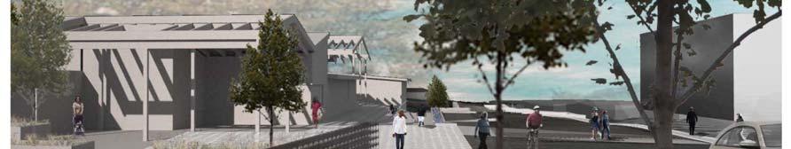

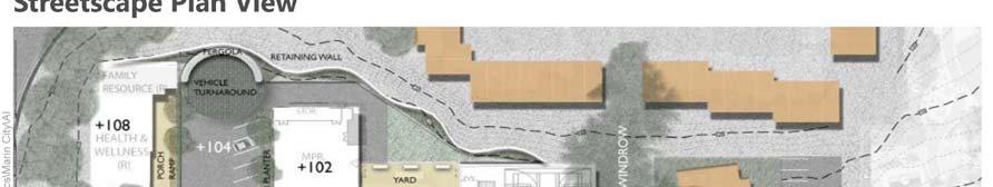

82 Figure 10: Streetscape Improvements Near Marin City Community Center 78
83 5.1.2 TRANSIT SERVICE EXPANSION Many Marin City residents rely on transit services provided by Marin Transit and Golden Gate Transit. A recurring theme in community feedback was the need for transit service to better meet the needs of the community. While in general, commute trips appear to be well-matched to community needs, there was a desire for transit to better accommodate the desired travel patterns of youth, seniors, and people with disabilities. These recommendations are intended to bridge the gap between transit service provision and service needs within the community in a cost-effective manner Study Transit Service Extending Beyond the Transit Hub This strategy would seek to study additional transit service within Marin City that extends beyond the transit hub located on Donahue Street by the Gateway Shopping Center. An example of this type of service could be a high frequency community loop shuttle that circulates through Marin City, providing a first mile/last mile connection for those who are unable to reach the Transit Hub through other means. A second example would be the extension of current transit routes beyond the transit hub and into the community. Since most of the neighborhoods in Marin City are located on hilly terrain, this strategy may also include research into vehicle types that would be best suited for operating on local Marin City streets. Estimated Cost Lead Agency Potential Funding Sources Timeframe $100,000 to $250,000 or more annually Marin Transit MTC Lifeline Program, Transportation Development Act (TDA) funds which include Local Transportation Funds (LTF) and State Transit Assistance (STA) funds, Measure A Sales Tax Funds, Fares Medium-term Convert Marin Transit Route 36 to All-Day Service This strategy would extend the hours of operation for Marin Transit Route 36 from peak period only service to all-day service. Route 36 provides access from Marin City to Strawberry, Corte Madera, and Downtown San Rafael. Marin Transit is currently evaluating this potential service augmentation as part of their current Short Range Transit Plan (SRTP) Update process. 79
84 Estimated Cost Lead Agency Potential Funding Sources Timeframe $400,000 annually Marin Transit MTC Lifeline Program, Transportation Development Act (TDA) funds which include Local Transportation Funds (LTF) and State Transit Assistance (STA) funds, Measure A Sales Tax Funds, Fares Medium-term Extend Marin Transit Service on Weekends Marin Transit Route 36 operated on Saturdays in Marin City until several years ago. Two years ago, Marin Transit extended weekend service on Routes 22 and 17 before 8:00 PM. This strategy would identify existing routes which may be good candidates for providing additional weekend service to Marin City, which could include Route 36. Estimated Cost Lead Agency Potential Funding Sources Timeframe $100,000 to $200,000 or more annually Marin Transit Transportation Development Act (TDA) funds which include Local Transportation Funds (LTF) and State Transit Assistance (STA) funds, Measure A Sales Tax Funds, Fares, MTC Lifeline Program Medium-term TRANSIT INFORMATION AND VEHICLE TECHNOLOGY Many members of the community expressed a desire for increased agency communication about available transportation options. Some community-members also requested increased trip information during transit travel and vehicular improvements that could serve to improve their trip experiences. Strategies that address these identified issues are presented in this section. Marin Transit and Golden Gate Transit are in the process of installing real time bus arrival signs at selected locations throughout their networks. The funding for this list of transit information and bus technology improvement strategies would most likely come through a series of specific transit grant programs and more general active transportation grant programs. These improvements can be implemented in a phased manner as funding becomes available. 80
85 Establish Transportation Information Storefront at Transit Hub This strategy would provide a transportation information storefront located near the community s transit hub. This storefront would provide information on all types of transportation services and programs available to community members, as well as real-time bus arrival information for the transit hub. The storefront could take one of the following forms: an unstaffed information terminal, a staffed semipermanent kiosk, or a staffed storefront where people could visit to speak to transportation outreach professionals. Two examples of unstaffed information terminals are Downtown Berkeley and Fruitvale (at the main BART station entrances). Estimated Cost Less than $100,000 Lead Agency Potential Funding Sources Timeframe Marin Transit and Golden Gate Transit MTC Lifeline Program, Active Transportation Program (ATP), Measure B, Transportation Demand Management funds, Safe Routes to Transit Program Medium-term Establish Transportation Discussion Item on CSD Board Agenda This strategy would establish an ongoing transportation discussion item on the agenda for the Marin City CSD Board, perhaps on a quarterly basis. This discussion item could be used for Board members to discuss transportation issues within the community, hear presentations with updates on service from transit agencies, the Transportation Authority of Marin, and the Flood Control District, listen to concerns from community members, or discuss pursuing grant funding to implement projects. Estimated Cost Lead Agencies Potential Funding Sources Timeframe No cost Marin City Community Services District, Marin County Department of Public Works, Marin Transit, Golden Gate Transit, Transportation Authority of Marin N/A Short-term Increase In-Person Marketing of Transportation Services This strategy would seek to increase the amount of in-person marketing of the transportation services to members of the community in order to enhance awareness and utilization of the services that are available. This strategy would be primarily focused upon seniors as a wider array of specialized transportation options are available for them. Appropriate strategies would include flyering and visitation to senior lunches which take place on Wednesdays at the Senior Center. Marin Transit is currently 81
86 producing a Countywide Transportation Guide that is planned for release in the first half of This strategy could incorporate that document as a tool to help market various services. Marin Transit has recently conducted Spanish language training and an extension of this service could be provided as part of the strategy. Estimated Cost Less than $100,000 Lead Agency Potential Funding Sources Timeframe Marin Transit Marin Transit Short-term PARATRANSIT AND CATCH-A-RIDE Paratransit is a mandated service for persons with disabilities who are unable to use the regular fixed route public transit service because of their disability. Paratransit service is designed to meet the Americans with Disabilities Act (ADA) service criteria established by the federal government. Service is provided only to individuals found eligible and is operated under the following guidelines: Service is only provided in areas where fixed route buses operate. ADA Paratransit vehicles can only make pick-ups at places that are within three-quarters of a mile of a bus route (which covers the entirety of Marin City), Service is provided only during the hours and days when fixed route service in that area operates, Rides must be reserved in advance, ADA Paratransit fares are $2-4 for a one-way local trip, and Service is provided for all types of trips. The scope of Paratransit service, as defined by the federal government and summarized above, cannot be expanded. However, expansion of the catch-a-ride program is one way that can help to ameliorate some of the limitations of paratransit service Establish a Dedicated, Demand-Responsive Service Tailored to Marin City Work with Marin Transit to establish a specialized demand-responsive service that provides a specific trip (or series of trips) that are frequently desired by members of the community during particular times 82
87 and/or days of the week. Examples of these kinds of trips include those to the transit hub to connect to regional service, for local grocery shopping trips, to regional shopping centers, to medical appointments for seniors with 2-3 hour stays, and for youth to sports practice and events outside of Marin City. This strategy would include purchase of an appropriate vehicle (such as a 15-seat van) that is accessible by youth, seniors, and people with disabilities. The CSD may be able to provide a driver for this service. This is the highest priority strategy for Golden Gate Transit and Marin Transit as it has the fewest barriers to implementation and they also consider it well-positioned to successfully meet the needs of the community. Estimated Cost Lead Agency Potential Funding Sources Timeframe $100,000 per vehicle purchase; $100,000 to $200,000 annual operating cost Marin Transit Lifeline Transportation Program (LTP), Measure A Sales Tax Funds, Measure B Short-term Increase Number of Trips Allowed on Catch-a-Ride This strategy would pursue grant funding to expand the number of trips allowed via the Marin Catch-a- Ride service to be greater than the current maximum of eight one-way trips per month. Estimated Cost Lead Agency Potential Funding Sources Timeframe Less than $50,000 per month Marin Transit Marin County Measure B Funds Short-term Study New Dial-a-Ride Services This strategy would pursue grant funding to study new dial-a-ride services that could be implemented for those who do not qualify for regular paratransit services. Estimated Cost Lead Agency Potential Funding Sources Timeframe Approximately $200,000 for study Marin Transit Marin County Measure B Funds Short-term 83
88 Establish a Car Sharing Service This strategy would establish a car sharing service within Marin City by partnering with local car-sharing companies (such as Zipcar and City Car Share). Car sharing services are located within the community meaning that cars can be accessed by walking without the need to travel to remote car rental locations. The Marin City Community Services District would work with these companies to provide a certain number of parking spaces (either on-street or off-street) for carsharing vehicles to meet the demands of the community. These spaces could be located next to the transit hub to leverage its rich transit connectivity. Estimated Cost $50,000 to $200,000 Lead Agency Potential Funding Sources Timeframe Transportation Authority of Marin MTC Climate Initiatives grant, Marin County Measure B Funds Medium-term to long-term PEDESTRIAN AND BICYCLE FACILITIES The following strategies are intended to make it easier and more pleasant to travel on bicycle or foot around Marin City. Some of these improvements should be implemented in conjunction with bus stop improvement projects as part of a system designed to improve the path of travel between transit stops and nearby residential and employment uses. The list of pedestrian and bicycle strategies identified would require funding to implement the improvements. The funding would most likely come through a series of specific safety grant programs and more general active transportation grant programs. The Marin Community Services District can implement the improvements in a phased manner as funding becomes available Improve Lighting and Aesthetics at the US 101 Underpass While lighting upgrades were identified in the 2009 CBTP and since implemented, the community (including some Junior High students) stated safety concerns and repeated their desire to further improve the walking experience underneath the US 101 underpass on Donahue Street. This strategy would involve pursuing funding to improve lighting and aesthetics for the pedestrian path that connects Marin City to Sausalito. The CSD is currently investigating the possibility of installing public artwork along the underpass to create a more welcoming community gateway. Marin County is considering changing streetlight bulb types to LED as the current bulbs are known to have a higher power requirement than the 84
89 solar panels are able to provide. The new LED bulbs have lower power requirements, and would result in a more well-lit underpass. Estimated Cost $100,000 to $250,000 Lead Agencies Potential Funding Sources Timeframe County of Marin, Caltrans Lifeline Transportation Program (LTP), Transportation for Livable Communities (TLC), Safe Routes to School Program (Federal, State, or Local), Active Transportation Program (ATP), Caltrans Office of Traffic Safety (OTS) Short-term Improve Pedestrian Path Quality and Lighting This strategy would seek to improve pedestrian paths and lighting throughout Marin City, which could include constructing new sidewalks, repairing existing sidewalks, installing striped crosswalks, and installing or repairing street lights. Drake Avenue and Cole Drive were identified as streets that could be improved. Estimated Cost Lead Agency Potential Funding Sources Timeframe $50,000 to $200,000 depending on improvement Marin City Community Services District (MCCSD) Measure A Sales Tax Funds (Safe Pathways program), Lifeline Transportation Program (LTP), Transportation for Livable Communities (TLC), Safe Routes to School Program (Federal, State, or MTC), Active Transportation Program (ATP) Long-term Increase School Participation in Safe Routes to School Program This strategy would seek to increase the participation of students in the Bayside Martin Luther King Jr. Academy and Willow Creek Academy in the Safe Routes to School Program. This program could include improving pedestrian and bicycle paths to and from the schools and providing outreach materials to encourage children to walk or bike to school. TAM currently has a funding program dedicated to Safe Routes to School programs and improvements. Estimated Cost $50,000 Lead Agency Potential Funding Sources Timeframe Transportation Authority of Marin Measure A Sales Tax Funds, Measure B Sales Tax Funds, Safe Routes to School Program (Federal, State, or MTC) Short-term 85
90 Implement a Walking School Bus for Children This strategy would implement a walking school bus to enhance safety for children who walk to Bayside Martin Luther King Jr. Academy and Willow Creek Academy. A walking school bus is a group of children walking to school with one or more adults. Providing adult supervision may help to reduce safety worries for families who live within walking or bicycling distance to school. The walking school bus could be a pilot program implemented as part of the Safe Routes to School program. Estimated Cost Lead Agency Timeframe N/A Transportation Authority of Marin Short-term Study Traffic Calming Measures on Cole Drive Cole Drive was also identified by the community as a location where automobile speeds are regularly perceived to be high. Marin Housing Authority and Marin County Department of Public Works have both identified this as a street where better access and visibility could be provided for pedestrians crossing Cole Drive. This strategy would conduct a study along Cole Drive to investigate what types of traffic calming measures could be used to reduce vehicle speeds. Estimated Cost $50,000 to $150,000 Lead Agency Potential Funding Sources Timeframe County of Marin (Department of Public Works) Transportation for Livable Communities (TLC), Active Transportation Program (ATP), Caltrans Office of Traffic Safety (OTS) Medium-term 5.2 PRIORITIZATION The transportation strategies described above were prioritized based on a series of criteria to provide Marin City with a tool for future transportation programming efforts and determination of grant solicitation priorities. The criteria used to prioritize the strategies were categorized by Effectiveness and Feasibility to identify projects that would most benefit the community as well as identify projects that would be the easiest to implement. By this approach, projects that would have the most benefit to the community but may be 86
91 difficult to implement would not lose their high importance. Respectively, projects that may not be as important to the community but would be easy to implement would not be overlooked. Within the Effectiveness and Feasibility categories, four criteria groups (two for each category) were used to further describe the relative effectiveness and feasibility of each project. Each potential project was evaluated by these criteria with a score of 1 (Low) to 3 (High), with High reflecting that the project best fit the criteria. The scoring was based on input from the Community Services District board, Technical Advisory Committee, Marin City community (through the Community Open House, surveys, and other outreach efforts), discussions with public agency staff, the overarching goals of the community-based transportation process, and relevant planning documents. The criteria used for this prioritization are described below: EFFECTIVENESS Community Has stakeholder support The success of any strategy requires that it has the support of key stakeholders within the community not only for determining its potential usage but also to support agency staff or community leaders in their efforts to make the strategy a reality. Does the strategy have the support necessary for success? Helps population with the greatest need (low-income) Does this strategy target the population with greatest barriers to mobility, specifically low-income groups? Benefits a large portion of the community Does this strategy improve transportation options for a wide-ranging segment of the population? Addresses the needs of elderly and/or disabled Does this strategy help overcome mobility barriers for elderly or disabled populations? Transportation Solves multiple transportation needs/gaps Does this strategy address multiple transportation needs or gaps as identified by the community? Improves connectivity beyond the community Does the strategy extend transportation services to connect the Marin City community to neighboring communities and/or the remainder of Marin County? Improves Safety Does this strategy help to improve the safety of the transportation system and its users? 87
92 5.2.2 FEASIBILITY Funding and Cost Cost effective Is the cost of the strategy reasonable as compared to the number of people who would benefit? Can the project sustain itself in the long term in a cost-effective manner? Funding Identified Has a potential funding source for the strategy been identified and/or committed? Low-cost or no-cost Can the strategy be implemented for a relatively low cost (or no cost) compared to other options? In addition, is it phaseable? Implementation Ease of implementation Does this strategy involve the cooperation of many jurisdictions and agencies? Does this strategy trigger compliance requirements that would result in adherence to local, state, and/or federal regulations? In addition, is there a group or individual that might champion this strategy or could such a champion or sponsor be identified? Can the strategy be completed within a short timeframe? Compatible with Local Plans Is this strategy directly identified by a local agency planning document or is it supportive of existing local plans? Can the project leverage other support adequate for being able to be compatible? RESULTS The proposed project prioritization is shown in rank order in Table 27. More detailed results of the project prioritization are shown in Table
93 TABLE 27: PROJECT PRIORITIZATION Strategy Effectiveness Score 1 Feasibility Score 1 Total Score Overall Rank Study and Improve Drainage on Donahue Street at US 101 Underpass Establish a Dedicated, Demand-Responsive Service Tailored to Marin City Study Secondary Access Point for Marin City Improve Pedestrian Path Quality and Lighting Establish Transportation Discussion Item on CSD Board Agenda Improve Lighting and Aesthetics at the US 101 Underpass Provide Streetscape Improvements to the New Community Center Increase School Participation in Safe Routes to School Program Establish a Car Sharing Service Increase In-Person Marketing of Transportation Services Expand Community Emergency Response Training (CERT) for Community Members Establish Transportation Information Storefront at Transit Hub Convert Marin Transit Route 36 to All-Day Service Implement a Walking School Bus for Children Extend Marin Transit Service on Weekends Increase Number of Trips Allowed on Catch-a-Ride Study Transit Service Extending Beyond the Transit Hub Study Traffic Calming Measures on Cole Drive Study New Dial-A-Ride Services Notes: 1. The Effectiveness and Feasibility Scores are the sum of several criteria scores (which are scored 1-3 individually). The Effectiveness Score is on a scale of 21 points (maximum), while the Feasibility Score is on a scale of 15 points (maximum). 89
94 TABLE 28: PROJECT PRIORITIZATION DETAILED RESULTS Effectiveness Feasibility Community Transportation Funding and Cost Implementation Strategy 90 Has stakeholder support Helps population with the greatest need (low-income) Benefits a large portion of the community Addresses needs of elderly and/or disabled Solves multiple transportation needs/gaps Improves connectivity beyond the community Improves Safety Cost Effective Funding Identified Low-cost or no-cost Ease of Implementation Compatible with Local Plans Total Points Overall Ranking Scoring: 3 points (High) = Project was best for this criteria; 2 points (Medium) = Project was average for this criteria; 1 point (Low) = Project was poor for this criteria Study and Improve Drainage on Donahue Street at US Underpass Establish a Dedicated, Demand- Responsive Service Tailored to Marin City Study Secondary Access Point for Marin City Improve Pedestrian Path Quality and Lighting
95 TABLE 28: PROJECT PRIORITIZATION DETAILED RESULTS Effectiveness Feasibility Community Transportation Funding and Cost Implementation Strategy 91 Has stakeholder support Helps population with the greatest need (low-income) Benefits a large portion of the community Addresses needs of elderly and/or disabled Solves multiple transportation needs/gaps Improves connectivity beyond the community Improves Safety Cost Effective Funding Identified Low-cost or no-cost Ease of Implementation Compatible with Local Plans Total Points Overall Ranking Establish Transportation Discussion Item on CSD Board Agenda Improve Lighting and Aesthetics at the US 101 Underpass Provide Streetscape Improvements to the New Community Center Increase School Participation in Safe Routes to School Program Establish a Car Sharing Service
96 TABLE 28: PROJECT PRIORITIZATION DETAILED RESULTS Effectiveness Feasibility Community Transportation Funding and Cost Implementation Strategy 92 Has stakeholder support Helps population with the greatest need (low-income) Benefits a large portion of the community Addresses needs of elderly and/or disabled Solves multiple transportation needs/gaps Improves connectivity beyond the community Improves Safety Cost Effective Funding Identified Low-cost or no-cost Ease of Implementation Compatible with Local Plans Total Points Overall Ranking Increase In-Person Marketing of Transportation Services Expand Community Emergency Response Training (CERT) for Community Members Establish Transportation Information Storefront at Transit Hub Convert Marin Transit Route 36 to All-Day Service Implement a Walking School Bus for Children
 Benefits a large portion of the community Addresses needs of elderly and/or disabled Solves multiple transportation needs/gaps Improves connectivity beyond the community")
97 TABLE 28: PROJECT PRIORITIZATION DETAILED RESULTS Effectiveness Feasibility Community Transportation Funding and Cost Implementation Strategy 93 Has stakeholder support Helps population with the greatest need (low-income) Benefits a large portion of the community Addresses needs of elderly and/or disabled Solves multiple transportation needs/gaps Improves connectivity beyond the community Improves Safety Cost Effective Funding Identified Low-cost or no-cost Ease of Implementation Compatible with Local Plans Total Points Overall Ranking Extend Marin Transit Service on Weekends Increase Number of Trips Allowed on Catch-a-Ride Study Transit Service Extending Beyond the Transit Hub Study Traffic Calming Measures on Cole Drive Study New Dial-A-Ride Services
98 6 IMPLEMENTATION There are a number of different opportunities for implementing the strategies recommended in Chapter 5. Potential avenues for implementation include pursuing grant funding, working with partner transit agencies, and working with non-profit groups. 6.1 FUNDING The following funding sources were identified as potential resources for implementation of the proposed initiatives of the CBTP FEDERAL Moving Ahead for Progress in the 21 st Century Act (MAP-21) Signed into law in July 2012, MAP-21 authorizes over $105 billion in funding for federal surface transportation funding for FY 2013 and FY Replacing SAFETEA-LU, MAP-21 consolidated many formula-based and discretionary funding programs supported under the prior authorization, including the National Highway System Program, Interstate Maintenance Program, Highway Bridge Program, and Appalachian Development Highway System Program Transportation Alternatives Transportation Alternatives funds are to be used to provide for alternative transportation projects that were previously eligible under several separately funded programs. Projects include recreational trails programs, planning, designing, or constructing roadways within former Interstate routes or divided highways, and Safe Routes to Schools programs. The goal of the Safe Routes to Schools program is to enable and encourage primary and middle school children to walk and bike to school by making it a safer and more appealing alternative. It also seeks to facilitate planning, development, and implementation of projects and activities that will improve safety and reduce traffic, fuel consumption, and air pollution in the vicinity of schools. Eligible projects include those related to infrastructure (planning, design, and construction) and non-infrastructure (public awareness). 94
99 Congestion Management and Air Quality Program (CMAQ) This program will fund the construction of bicycle and pedestrian facilities as well as bicycle safety programs, which include brochures, maps, and public service announcements. The projects must be primarily for transportation rather than recreation and included in Transportation Improvement Projects (TIP). It requires a 20 percent local or state match Access to Jobs and Reverse Commute Program (JARC) JARC funds are primarily distributed through MTC s Lifeline Program although certain grants may be available directly from the Program. The federal Access to Jobs and Reverse Commute Program (JARC) is a discretionary funding source that funds projects and services designed to transport low-income persons to work, training, and child care and supports development of transportation services between urban centers and suburban employment opportunities. Funds can be used for capital improvements or operating expenses requiring a 20 percent local match for capital projects and 50 percent local match for operating expenses. Eligible projects include: New or expanded transportation projects or services that provide access to transportation; Promoting public transportation by low-income workers, including the use of public transportation by workers with nontraditional work schedules; Promoting the use of transit vouchers for welfare recipients and eligible low-income individuals; Promoting the use of employer-provided transportation, including the transit pass benefit program under section 132 of the Internal Revenue Code of 1986; Subsidizing the costs associated with adding reverse commute bus, train, carpool, van routes, or service from urbanized areas to suburban workplaces; Subsidizing the purchase or lease by a nonprofit organization or public agency of a van or bus dedicated to shuttling employees from their residences to a suburban workplace; or Facilitating public transportation services to suburban employment opportunities Community Development Block Grants (CDBG) The CDBG program is a federal program of grants to larger cities and urban counties, administered by the U.S. Department of Housing and Urban Development (HUD). CDBG funds allocate annual grants to develop viable communities by providing decent housing, a suitable living environment, and opportunities to expand economic opportunities, principally for low- and moderate- income persons. CDBG funds may be used for: Acquisition of real property; 95
100 Relocation and demolition; Rehabilitation of residential and non-residential structures; Construction of public facilities and improvements, such as water and sewer facilities, streets, neighborhood centers, and the conversion of school buildings for eligible purposes; Public services, within certain limits; Activities relating to energy conservation and renewable energy resources; and Provision of assistance to profit-motivated businesses to carry out economic development and job creation/retention activities Hazard Elimination Safety Program (HES) The HES is a federal safety program monitored by Caltrans that provides funds for safety improvements on any public road, public surface transportation facility, publicly-owned bicycle or pedestrian pathway or trail, or traffic calming measure. These funds serve to eliminate or reduce the number and severity of traffic accidents at locations selected for improvement. Activities that are eligible include preliminary engineering, right-of-way costs, and construction expenses. Any local agency may apply for these safety funds for up to 90 percent of project costs, requiring a local match of 10 percent STATE Safe Routes to School Program The Safe Routes to School (SR2S) program, originally designed to last five years, has been extended indefinitely under AB 57. This program is administered by Caltrans. Projects must be on a route to school and must improve bicycle and pedestrian travel. Eligible projects are rehabilitation, new bikeways and sidewalks, and traffic calming. Grants are allocated competitively. A 10 percent local match is required for all projects. Applications are typically due in May or June of each year Active Transportation Program (ATP) In September 2013, the Governor signed Senate Bill 99 (Chapter 359, Statutes 2013) and Assembly Bill 101 (Chapter 254, Statutes 2013) into law, creating the Active Transportation Program (ATP). The ATP consolidated a number of other funding sources intended to promote active transportation, such as the Bicycle Transportation Account and Transportation Alternatives Program, into one program. The ATP is administered by Caltrans Division of Local Assistance, Office of Active Transportation and Special Programs. Selected projects must achieve at least one of the following goals: 96
101 Increase the proportion of trips accomplished by biking and walking, Increase safety and mobility for non-motorized users, Advance the active transportation efforts of regional agencies to achieve greenhouse gas (GHG) reduction goals, Enhance public health, Ensure that disadvantaged communities fully share in the benefits of the program, and Provide a broad spectrum of projects to benefit many types of active transportation users REGIONAL/LOCAL Local Lifeline Transportation Program MTC s Transportation 2030 Plan seeks $216 million over the next 25 years to address mobility needs for residents of low income communities. In response to this need, MTC has instituted the Lifeline Transportation Program to distribute this program using JARC and STA funds. The fourth cycle of funding was recently announced by the MTC and funds are expected to be available by Spring It is estimated that Marin County will receive $1,030,406 for the three-year period of FY The Lifeline Program replaces the Low Income Flexible Transportation Program (LIFT) grants previously distributed by MTC. Lifeline monies can be used for capital or operating purposes for projects which are developed through a collaborative process between public agencies, transit operators, community-based organizations, and other community stakeholders, including outreach to under-represented stakeholders. Lifeline funds are earmarked for projects that address transportation gaps and/or barriers identified through a Community-Based Transportation Plan (CBTP), countywide or regional Welfare-to-Work Transportation Plan or are otherwise documented as a need within the community and that improve a range of transportation choice by adding new or expanded services. Eligible operating projects include enhanced fixed route transit services, shuttles, children s programs, taxi voucher programs, improved access to autos, and capital improvement projects. Capital projects that do not require ongoing funding are encouraged and may include the purchase of vehicles, the provision of bus shelters, benches, lighting, sidewalk improvements or other enhancements to improve transportation access for residents of lowincome communities. Strategies specific to meeting the transportation needs of elderly or disable residents of low-income communities may also be considered for Lifeline funds. Lifeline funding requires a 20 percent local match Measure A Sales Tax Funds Transportation Sales Tax Expenditure Plan (Measure A) defines how a ½ cent sales tax increase approved by voters on November 2, 2004 will be spent. The purpose of the plan is to improve transportation in 97
102 Marin by expanding bus service, completing the Highway 101 carpool lane through San Rafael, and providing roadway improvements and safer access to schools. The four key strategies include: A seamless local bus system that serves community needs, including special services for seniors and those with disabilities Fully fund and accelerate completion of the Highway 101 Carpool Lane Gap Closure Project through San Rafael Improve, maintain, and manage Marin s local transportation infrastructure, including roads, bikeways, pathways, and sidewalks Reduce school-related congestion and improve safe access to schools Measure B The Marin County Vehicle Registration Fee (VRF) Expenditure Plan, approved by voters as Measure B in November 2010, dedicates an estimated $2 million annually in VRF revenues to the transportation projects and programs needs in Marin. The primary goal of Measure B is to support transportation investments in a way that sustains Marin County s transportation network and reduces traffic congestion and vehicle-related pollution. To achieve this goal three elements are identified, with sub strategies identified below: Element 1: Maintain Local Streets and Pathways o o 1.1. Maintain Local Streets 1.2. Maintain Class I Bike/Ped Pathways Element 2: Improve Transit for Seniors and Persons with Disabilities o o o o o 2.1. Paratransit Plus 2.2. Volunteer Driver Program Support 2.3. Low Income Rider Scholarships 2.4. Gap-Grant Program 2.5. Mobility Management Staffing Element 3: Reduce Congestion and Pollution o o o 3.1. School Safety and Congestion Reduction 3.2. Local Marin County Commute Alternatives 3.3. Alternative Fuels Infrastructure and Promotion Transportation Development Act, Article 3, Pedestrian/Bicycle Projects Transportation Development Act (TDA) Article 3 funds are return-to-source funds generated from the sales tax on gasoline. They are returned to the source county for local transportation projects; two percent 98
103 of these funds are set-aside for bicycle and pedestrian projects. These funds can be used for engineering, right-of-way acquisition, construction, retrofitting to comply with the American Disabilities Act (ADA), route improvements, and purchase and installation of facilities such as parking, benches, restrooms, changing areas, showers which are adjacent to bicycle trails, bicycle traffic generators, and are accessible to the general public. Each county decides its own formula for allocating the funds to the local jurisdictions within that county. These funds can be used directly for bicycle and pedestrian projects or as the local match for competitive State and Federal sources. Projects must be approved by a local Bicycle Advisory Committee and included in the bicycle plan, transportation element, or other adopted plan Transportation for Livable Communities (TLC) The purpose of this funding source is to support community-based transportation projects that bring new vibrancy to downtown areas, commercial cores, neighborhoods, and transit corridors. TLC provides funding for projects that are developed through an inclusive community planning effort, provide for a range of transportation choices, and support connectivity between transportation investments and land uses. Three types of TLC funds are available. Regional TLC funds are regionally competitive and can be used for planning or capital improvements. Local TLC and Local HIP funds are available for projects within Marin County and can only be used for capital improvements. An update to the program in 2010 only allows for projects to be located within Priority Development Areas (PDAs) as identified by the Association of Bay Area Governments (ABAG). In addition, the program can now also support non-transportation infrastructure improvements (such as sewer upgrades), Transportation Demand Management projects, and Density Incentives (direct funding for transit-oriented development land banking or site assembly). The capital program will fund transportation infrastructure improvements to pedestrian, bicycle, and transit facilities. The key objectives of this program are to: Encourage pedestrian, bicycle, and transit trips; Support a community s larger infill development or revitalization effort; and Provide for a wider range of transportation choices, improved internal mobility, and stronger sense of place Project activities eligible for funding include bicycle and pedestrian paths and bridges, on-street bike lanes, pedestrian plazas, pedestrian street crossings, street scapes such as median landscaping, street trees, lighting, and furniture, traffic calming design features such as pedestrian bulb-outs or transit bulbs, transit stop amenities, way-finding signage, and gateway features. Funds can be used for preliminary engineering (design and environmental), right-of-way acquisition, or construction. TLC capital grants allocate federal Surface Transportation Program (STP) or Congestion Mitigation and Air Quality (CMAQ) Improvements Program Funds with grants ranging from $500,000 to $3 million per project. A local match 99
104 of 11.5 percent of the total project cost is required. Projects in the early or conceptual stage of their development are eligible for TLC planning grants of up to $75,000, which are awarded to help sponsors refine and elaborate promising project ideas Transportation Fund for Clean Air (TFCA) The TFCA is a grant program funded by a $4 surcharge on motor vehicles registered in the Bay Area. This generates approximately $22 million per year in revenue. TFCA s goal is to implement the most costeffective projects in the Bay Area that will decrease motor vehicle emissions, and therefore improve air quality. Projects must be consistent with the 1988 California Clean Air Act and the Bay Area Ozone Strategy. TFCA funds covers a wide range of project types, including purchase or lease of clean fuel buses; purchase of clean air vehicles; shuttle and feeder bus service to train stations; ridesharing programs to encourage carpool and transit use; bicycle facility improvements such as bike lanes, bicycle racks, and lockers; arterial management improvements to speed traffic flow on major arterials; smart growth; and transit information projects to enhance the availability of transit information. Applications are submitted through the Bay Area Air Quality Management District or through the County Congestion Management Agency NON-TRADITIONAL The Mello-Roos Community Facilities Act of 1982 In 1978, Californians enacted Proposition 13, which limited the ability of local public agencies to increase property taxes based on a property s assessed value. In 1982, the Mello-Roos Community Facilities Act of 1982 (Government Code S ) was created to provide an alternate method of financing needed improvements and services. The Act allows any county, city, special district, school district, or joint powers authority to establish a Mello-Roos Community Facilities District (CFD) which allows for financing of public improvements and services. The services and improvements that Mello-Roos CFDs can finance include streets, sewer systems, and other basic infrastructure, police protection, fire protection, ambulance services, schools, parks, libraries, museums, and other cultural facilities. By law, the CFD is also entitled to recover expenses needed to form the CFD and administer the annual special taxes and bonded debt California Conservation Corps (CCC) The program provides emergency assistance and public service conservation work for city, county, state, federal, and non-profit organizations. Both urban and rural projects are eligible and are selected on the basis of environmental and natural resource benefits and public use and on-the-job training opportunities. Use of the CCC would be effective at reducing project costs. 100
105 Grant and Foundation Opportunities Private foundations provide excellent opportunities for funding specific capital projects or single event programs. Generally to qualify for these types of funds, a Bicycle Advisory Committee or established nonprofit group acting in its behalf must exist. In general, private foundations are initially established for specific purposes (e.g. children and youth need, promotion of certain professional objectives, educational opportunities, the arts, and community development). An excellent source of information about foundations and their funding potential can be found in the Foundation Directory, available at many public libraries or online at Several foundations to consider are listed below Marin Community Foundation (MCF) The MCF was established in 1986 with the assets of a trust created by Leonard and Beryl H. Buck, longtime residents of Marin County. Since that time, over 300 additional funds have been created at the Foundation. Grants made from these funds support a wide range of issues within Marin County, the United States, and around the world. The mission of the MCF is to encourage and apply philanthropic contributions to help improve the human condition, embrace diversity, promote a humane and democratic society, and enhance the community s quality of life, now and for future generations. The Foundation s Discretionary Grants program supports efforts that are conducted in Marin County or that benefit the residents of the County. Support is given for general operating support, special projects and initiatives, and ongoing programs depending on the focus and goals within each of the Foundation s program areas which include the Arts, Community Development, Education and Training, Environment, Human Needs, and Religion, Ethics, and Conscience Surdna Foundation The Community Revitalization program of the Surdna Foundation seeks to transform environments and enhance the quality of life in urban places, increase their ability to attract and retain a diversity of residents and employers, and ensure that urban policies and development promote social equity Zellerbach Family Foundation The Mission of the Zellerbach Family Foundation is to be a catalyst for constructive social change by initiation and investing in efforts that strengthen families and communities. The areas focusing on improving human service systems and strengthening communities would support local community improvement efforts 101
106 Bike Belong Coalition Bike Belong is the national coalition of bicycle suppliers and retailers working together to put more people on bicycles more often. Through national leadership, grassroots support, and promotion, they work to make bicycling safe, convenient, and fun. Bike Belong Coalition will support non-profit organizations and public agencies with development of facilities, education programs, and advocacy efforts. 6.2 NEXT STEPS This Community-Based Transportation Plan provides a list of improvement strategies and projects to support efforts by TAM and the Marin City CSD to pursue federal, state, regional, and local funds to implement the recommended projects and programs FUTURE GRANT OPPORTUNITIES A prioritization matrix was developed in conjunction with this Plan (Table 27 and Table 28). The purpose of the matrix is to provide a database of projects and programs, rated against a series of criteria that are both important to the community and those that are frequently used for grant programs. This will allow agency staff to select projects for future grant applications that are targeted based on each grant program s specific criteria. The Plan also provides preliminary cost estimates for each project or program. The first known opportunity for grant funding is a regional funding program administered by the Metropolitan Transportation Commission (MTC). MTC s Lifeline Transportation Program supports projects that address mobility and accessibility needs in low-income communities throughout the region. It is funded by a combination of federal and state operating and capital funding sources, including the Federal Transit Administration s Section 5307/Job Access and Reverse Commute Program, and state Proposition 1B Transit Capital and State Transit Assistance program. In the first three funding cycles, approximately $190 million in Lifeline funding was programmed to 224 projects throughout the nine-county region. Projects include a variety of solutions tailored to local priorities, including fixed-route transit, transit stop improvements, pedestrian and bicycle access improvements, senior and children s transportation, community shuttles, auto loan programs, and mobility management activities. Marin County agencies received a total of $2.5 million in Lifeline funding in the Third Cycle (FY ). GGBHTD also received $726,000 in funding during the Third Cycle for an Advanced Communication and Information System that includes real-time passenger information signs. 102
107 APPENDIX: COMMUNITY OUTREACH
108 - Appendix APPENDIX COMMUNITY OUTREACH FOCUS GROUP NOTES Copied below are the focus group notes from individual sessions. YOUTH Name: Matthew Crane Venue: Marin City Senior Center Attendee Type: Teens Date: 10/14/14 Time: 3:30-4:30 p.m. Number of Attendees: 18 (Grades 5-8) Introductory Questions 1. How do you (and your family) get around Marin City? a. First Group i. Bike 0 ii. Walk - 3 iii. Dropped off 4 iv. Other 2 v. Bus to go get groceries vi. Walks to school and the Gateway shopping center. Car for groceries, etc. vii. Bus to school. Car to go shopping. b. Second Group i. #1: Mom has 1 car for transportation, but walks to school ii. #2: No car, walks to school, takes bus to go shopping iii. #3: Walk to school, bus to go shopping iv. #4: Car to school and for shopping, bike to park v. #5: Bus to school, carpool in another family s car to go shopping vi. #6: Walk to the school and the mall (Gateway Shopping Center?), car for longer-distance shopping, but also takes the bus to go shopping, movies, and football practice vii. #7: Bus to school, car for shopping, bike for recreation viii. #8: Bus to school, car for shopping and doctor appointments, bike for recreation but doesn t use often, bus to mall, MV (Mountain View?), and Santa Rosa 2. Where do you go in (and outside of) Marin City? a. First Group i. Stockton via car ii. Northgate Mall via bus (Route 70) iii. Into Sausalito b. Second Group i. #1: San Jose Flea Market ii. #2: Shopping (did not identify specific location) iii. #3: Shopping (did not identify specific location) iv. #4: Shopping and the park (no specific locations identified) v. #5: Shopping (did not identify specific location) 1
109 - Appendix vi. #6: Malls, Movie Theaters, and Football practice (Tamalpais?) vii. #7: Shopping (did not identify specific location) viii. #8: Shopping, MV (Mountain View?), Santa Rosa 3. What challenges do you have in getting places? a. First Group i. Route 70 bus out of schedule (arrives and departs early) ii. Most seem to be comfortable riding bike on the street, except when passing under the US-101 bridge (high traffic volume and poor lighting) b. Second Group i. #1: Walk to school, but could bike if bike was fixed and had a lock for it ii. #2: Has bike, but it is broken iii. #3: No bike iv. #4: No difficulties v. #5: Car is broken, so need to carpool to go shopping vi. #6: No response vii. #7: No response viii. #8: Has bike, but doesn t ride often (didn t specify why) ix. Would prefer to have a transit pass instead of needing to pay cash on bus every time. 4. How might we improve transportation in Marin City to be more accommodating to everyone, including seniors/students/etc? a. First Group i. Shuttle that goes in a loop around Marin City, instead of only one main stop at the hub. ii. Better lighting on ped path at underpass to US-101. b. Second Group i. #1: No response ii. #2: No response iii. #3: No response iv. #4: No response v. #5: No response vi. #6: No response vii. #7: No response viii. #8: No response Category General Issue Specific Location(s) ADA/Paratransit/Ride sharing None identified Felt unsafe riding on the street under US 101 bridge US 101 underpass Bicycles due to high traffic volume and poor lighting Bike is broken, so unable to ride Bus Stops Would prefer more bus stops throughout the community, instead of just one location. Dial-A-Ride Program No issues identified Pedestrian Facilities Poor lighting US 101 underpass pedestrian path Outreach No issues identified Taxi System Program No issues identified Transit Fares/Passes Would like to have transit passes instead of needing to pay cash fare every time Transit Service Buses running out of sync with published schedule, Route 70 resulting in missed trip Transit Travel Experience No issues identified 2
110 - Appendix SENIORS Marin City Focus Group Notes - Seniors November 5th, :15am Andy Kosinski (Fehr & Peers) & Lisa Newman (TAM) *Total of 16 people in attendance General Needs It was remarked that seniors needs are generally not well served by transportation in Marin City. Top Destinations Grocery stores o Safeway in Mill Valley, o Lucky s in Larkspur, o Big G/Molly s (although it s seen as being too expensive) Shopping centers o Currently poor access to shopping centers in Terra Linda and Corte Madera Medical destinations: o Marin General, o Kaiser (Terra Linda), o Downtown San Rafael Kaiser Transit Service Areas with many seniors identified to be lacking in local transit service: o Park Circle o Drake Avenue o The high-rises on Cole Drive Discontinued Marin Transit Route 222 was discussed: o Residents were disappointed that the service was discontinued after only 18 months and that it didn t give people enough time to adapt to it and change their habits. o Route 222 was not able to get to areas to access seniors where it needed to. o A senior noted that during a blues festival the route served the whole city and not just a few streets, and that broader reach was important. o Reliability, i.e. schedule adherence, was a big issue and people lost faith in the service over time. o Route 222 went to Strawberry Safeway parking lot (good) but didn t enter the lot or area of shelter for Trader Joe s. That would need to be rectified. Extended hours for transit: o One senior requested service outside of commute hours for Golden Gate Transit Route 2. People spend 1 to 2 hours at the store and transit service needs to recognize this by making sure they have enough time to do shopping between drop-off and pick-up options. o 2-3 hours is also a typical window for medical services. o 2 hours is a typical window for people to shop and have appointments. Buses are getting better at announcing the stops they are serving next. Extended service at weekends was requested for bus service. Catch-a-Ride One senior reported using catch-a-ride to go to church in Mill Valley, but was disappointed that she only gets 8 rides per month on the service. Outreach Flyers (especially in mailboxes) and posters (including at bus stops) are the best way to reach out to the community. o Sometimes flyers posted by transportation agencies are below eye level and are difficult to see. If another shuttle were instituted, outreach to the community through flyers and suchlike would be crucial. If was felt that advertising was conducted poorly for Route
111 - Appendix Seniors come for lunch at the Senior Center on Wednesdays, which would be a good occasion for publicity. Food pantries would also be a good venue for publicity. When introducing new services, agencies need to do better at publicizing schedules. YOUTH Marin City Focus Group Notes MLK Coalition November 13th, pm Andy Kosinski (Fehr & Peers) & Derek McGill (TAM) *Total of 20 people in attendance Surveys were handed out and Johnathan Logan was tasked to collect surveys at the conclusion of the meeting Introduction Derek introduced the plan process and funding sources available for recommendations from this plan. Andy spoke about the recommendations from the 2009 plan and gave status updates on each of the 12 recommendations. Derek noted the distinctions between the Lifeline Transportation funds and the PDA-related state grant moneys and that this plan would not be a precursor to grant funding for PDA-related grants. o (Action Item) The coalition requested that Derek provide documentation of past projects funded under the PDA statewide funding cycle Pedestrian Liz Darby of CDC has a list of spot locations in Marin City for sidewalk improvements that she would provide upon request o (Action Item) Andy to request list of sidewalk improvements candidate locations from Liz Darby. o Drake Avenue was noted as a street with deficient sidewalks in many places along it. Paratransit Catch-a-ride only sponsors enough for a one-way trip and often does not subsidize the full round trip, which means that people sometimes use it in one direction and have to arrange other transportation for the return leg (e.g. friend/family pick-up). Suggest that the subsidy limit be raised. Qualification for the Whistlestop service is prohibitive and even then there is a waiting list for it. Many seniors do not qualify. Whistlestop drivers are not hands-on in that they do not walk the patron to the door of the destination, which deters some from riding as they cannot travel between where the vehicle drops them off and the front door of their destination. Outreach Route 222 did not appear to have sufficient outreach or advertising. There needs to be more in-person marketing of services throughout the community. A community transportation advisory board could be set up to give feedback to the community on progress of transportation projects. Transit There is a lot of duplication of service between Marin Transit and Golden Gate Transit. New transit service must fill in the gaps that GGT does not cater. Route 222: o The bus used was too big to serve Village Oduduwa. o Because vehicle type restricted access to certain streets and grades, a new vehicle type should be researched which can serve these hilly areas and narrow streets. Students of Tam High or Redwood High have to wait an hour if they miss their bus. There should be an additional transit service for these students. o (Action Item) Denny and Allen are the two contacts for high school students the CBTP team 4
112 - Appendix should contact them to help coordinate high school focus group. Bridgegap college prep takes place four times a week and would be another good venue for a focus group. Seniors require more weekend service. There needs to be transit service connecting the downtown hub to the neighborhoods on the hillsides seniors and others find it very difficult to traverse these distances on foot. A dedicated bus serving seniors could be provided that serves the senior center (640 Drake Avenue) and senior needs. The senior center could possibly coordinate the service. The location of the senior center is one of high need. There was a concern that since a recent schedule change, some people find it more difficult to transfer between routes at the transit hub as different routes are not as coordinated. OPEN HOUSE FEEDBACK PUBLIC COMMENT NOTES (ANDY KOSINSKI) Cannot even get taxi from CVS up the hill. Dearth of transportation options! Stop sign enforcement, especially during commute hours. Low floor loading on buses for disabled (no steps) Money/fare box at back of bus as driver cannot take money. Speed bumps on Cole Drive, or other traffic calming Separate buses for students. Or a bus dedicated to school and seniors. Dollar Store 4-way everyone goes before pedestrian. Enforcement? Shuttle to Safeway! Separate buses for students separate from regular people. No quake plan/tsunami plan for Marin City! Honolulu small bus vehicles, as a best practice Terri: o Low ridership, Route 222. o The bus didn t serve the community! o Route didn t go to Village Oduduwa, for example o Need to revisit. Clarify 2F. Currently vague and no accountability. Only food delivery is Dario s Pizza because unsafe. Forward survey to s collected. Flood risk maps are incorrect. Unreliable. Designated parking places have not been provided from a process that began in June. PUBLIC COMMENT NOTES (BOB GRANDY) M.T. o Can there be dedicated buses for high school trips that could later in day be used for seniors? Mary Davis / 79 Cole o Small shuttle for seniors long walk up hill from transit center. o Disabled need $ at back of bus, where enter, can t get down aisle with walker. o Donahue/Cole people don t stop at 4 way stop. People crossing to transit (???) Need traffic calming on Cole Signal long delay for pedestrians. o No earthquake plan for Marin City o Honolulu little buses to get up hills 5
113 - Appendix Terry o Need to revisit 222 need to go into side streets. WRITE-IN COMMENTS FROM PRIORITIZATION SURVEY Re: 2E, Discounted student fare passes Isn t this already happening? Re: 2G, Shuttle to out-of-town shopping centers and markets Grocery store Maria doesn t feel safe at the transit stop near her house. Lighting or a closer bus stop could help or an alternative option like a taxi. Cole Dr. Marin. Need a shuttle for seniors for groceries/etc. Dedicated one for M. City. Make it easier for disabled to get on and off a GGB Transit Bus have money place in back of bus. Put speed bumps on Cole Dr. before someone is killed! Change lights at 4 way cross at 99 store to let pedestrian go first not last! Need earthquake plan here in Marin City!! Why wasn t survey sent in mail? Community members need to be involved on ALL committees SURVEY RESPONSES Copied below is the full summary of survey response data. 6


114 - Appendix 7
115 - Appendix 8

116 - Appendix 9
117 - Appendix 10

118 - Appendix 11


119 - Appendix 12
120 - Appendix 13
121 - Appendix 14
122 - Appendix Note that the following areas were also indicated as areas of difficulty on maps that accompanied the printed surveys: Village Oduduwa o o Park & Drake difficulty walking Park & Donahue difficulty bicycling, getting to/from bus, getting around in general Terrace Terrace Way Village Oduduwa Cole Dr Flemings Terrace Dr Cole Drake Ave Cole Dr Terrace Terners Dr 15
123 - Appendix 16

124 - Appendix 17


125 - Appendix 18

126 - Appendix 19
127 - Appendix 20


128 - Appendix 21

129 - Appendix 22

130 - Appendix 23


131 - Appendix 24
Chapter 14 PARLIER RELATIONSHIP TO CITY PLANS AND POLICIES. Recommendations to Improve Pedestrian Safety in the City of Parlier (2014)
") Chapter 14 PARLIER This chapter describes the current status and future plans for biking and walking in the City of Parlier. RELATIONSHIP TO CITY PLANS AND POLICIES The Parlier General Plan is the primary
Chapter 14 PARLIER This chapter describes the current status and future plans for biking and walking in the City of Parlier. RELATIONSHIP TO CITY PLANS AND POLICIES The Parlier General Plan is the primary
1999 On-Board Sacramento Regional Transit District Survey
 SACOG-00-009 1999 On-Board Sacramento Regional Transit District Survey June 2000 Sacramento Area Council of Governments 1999 On-Board Sacramento Regional Transit District Survey June 2000 Table of Contents
Memorandum. Fund Allocation Fund Programming Policy/Legislation Plan/Study Capital Project Oversight/Delivery Budget/Finance Contract/Agreement Other:
 Memorandum Date: November 20, 2017 To: Transportation Authority Board From: Eric Cordoba Deputy Director Capital Projects Subject: 12/5/17 Board Meeting: San Francisco Freeway Corridor Management Study
Marin s ½-cent Transportation Sales Tax
 Marin s ½-cent Transportation Sales Tax In 2004, Marin County voters approved a ½-cent sales tax measure to fund local transportation projects. On November 6, voters will have the opportunity to renew
Transportation Authority of Marin Renew Existing ½-cent Transportation Sales Tax
 Transportation Authority of Marin Renew Existing ½-cent Transportation Sales Tax Request for Approval of the Final Sales Tax Renewal Expenditure Plan Town of Tiburon June 20, 2018 Request Council to Approve
Chapter 13 ORANGE COVE
 Chapter 13 ORANGE COVE This chapter describes the current status and future plans for biking and walking in the City of Orange Cove. RELATIONSHIP TO CITY PLANS AND POLICIES The Orange Cove General Plan
Chapter 5 Future Transportation
 Chapter 5 Future Transportation The Future Land Use Plan identifies the desired land use designations. The land uses desired for Crozet depend, in large part, on the success of the transportation system,
A Matter of Fairness: ROCOG s Environmental Justice Protocol. What is Mobility Limitation?
 No Person Left Behind What is Mobility Limitation? What is the Access Limitation? Environmental Justice population should be provided adequate mobility & access to meet their needs; Identify acceptable
SANTA CLARA COUNTYWIDE BICYCLE PLAN August 2008
 SANTA CLARA COUNTYWIDE BICYCLE PLAN August 2008 To assist VTA and Member Agencies in the planning, development and programming of bicycle improvements in Santa Clara County. Vision Statement To establish,
University Of Maryland
 2000 Census Census Data 200 Census Change 2000 to 200 SUBJECT Number Percent SUBJECT Number Percent Number Percent TOTAL POPULATION 437 TOTAL POPULATION 246-9 -43.7 White 283 64.8 White 65 67. -8-4.7 Black
TRANSPORTATION COMMISSION Agenda Staff Report
 TRANSPORTATION COMMISSION Agenda Staff Report Agenda Item No. 5.a DATE: JULY 31, 2014 TO: FROM: SUBJECT: TRANSPORTATION COMMISSION COMMUNITY DEVELOPMENT DEPARTMENT - PLANNING DRAFT OLYMPIC CORRIDOR PREFERRED
Typical Rush Hour Commute. PennyforTransportation.com
 Typical Rush Hour Commute In the News Overview of the Plan Collaborative plan with projects in every community Prioritizing connectivity and congestion relief Dedicated transportation-specific funding;
I-105 Corridor Sustainability Study (CSS)
") I-105 Corridor Sustainability Study (CSS) Metro Streets and Freeways Subcommittee March 21, 2019 Gary Hamrick Cambridge Systematics, Inc. I-105 CSS Project History & Background Funded by Caltrans Sustainable
I-105 Corridor Sustainability Study (CSS) Metro Streets and Freeways Subcommittee March 21, 2019 Gary Hamrick Cambridge Systematics, Inc. I-105 CSS Project History & Background Funded by Caltrans Sustainable
Purpose and Need. Chapter Introduction. 2.2 Project Purpose and Need Project Purpose Project Need
 Chapter 2 Purpose and Need 2.1 Introduction The El Camino Real Bus Rapid Transit (BRT) Project (Project) would make transit and other transportation improvements along a 17.6-mile segment of the El Camino
CITY OF COCOA BEACH 2025 COMPREHENSIVE PLAN. Section VIII Mobility Element Goals, Objectives, and Policies
 CITY OF COCOA BEACH 2025 COMPREHENSIVE PLAN Section VIII Mobility Element Goals, Objectives, and Policies Adopted August 6, 2015 by Ordinance No. 1591 VIII MOBILITY ELEMENT Table of Contents Page Number
CONNECTING PEOPLE TO PLACES
 CONNECTING PEOPLE TO PLACES 82 EAST BENCH MASTER PLAN 07 Introduction The East Bench transportation system is a collection of slow moving, treelined residential streets and major arteries that are the
EXECUTIVE SUMMARY... vii 1 STUDY OVERVIEW Study Scope Study Area Study Objectives
 Contents EXECUTIVE SUMMARY... vii 1 STUDY OVERVIEW... 1-1 1.1 Study Scope... 1-1 1.2 Study Area... 1-1 1.3 Study Objectives... 1-3 2 EXISTING CONDITIONS... 2-1 2.1 Existing Freeway Conditions... 2-4 2.1.1
AAMPO Regional Transportation Attitude Survey
 AAMPO Regional Transportation Attitude Survey Traditionally Underserved Populations helping organizations make better decisions since 1982 2018 Submitted to the AAMPO By: ETC Institute 725 W. Frontier
TRANSIT & NON-MOTORIZED PLAN DRAFT FINAL REPORT Butte County Association of Governments
 1 INTRODUCTION Maintaining a high quality of life is the essence of this plan for transit and non-motorized transportation in Butte County. Curbing greenhouse gas emissions (GHG) by reducing congestion,
Pocatello Regional Transit Master Transit Plan Draft Recommendations
 Pocatello Regional Transit Master Transit Plan Draft Recommendations Presentation Outline 1. 2. 3. 4. What is the Master Transit Plan? An overview of the study Where Are We Today? Key take-aways from existing
Key objectives of the survey were to gain a better understanding of:
 3 COMMUNITY INPUT Community input is an essential part of corridor studies. For the SR 87 corridor study, VTA staff conducted an extensive online survey of people living and commuting along the corridor.
Bikeway action plan. Bicycle Friendly Community Workshop March 5, 2007 Rochester, MN
 Bikeway action plan Summary The was held on March 5, 2007 at the Rochester Mayo Civic Center. The workshop was hosted by Rochester-Olmsted County Planning Department in collaboration with the League of
4. ENVIRONMENTAL IMPACT ANALYSIS 9. TRANSPORTATION AND TRAFFIC
 4. ENVIRONMENTAL IMPACT ANALYSIS 9. TRANSPORTATION AND TRAFFIC 4.9.1 INTRODUCTION The following section addresses the Proposed Project s impact on transportation and traffic based on the Traffic Study
TRANSPORTATION TRAINING TOPICS. April 6, 2010
 TRANSPORTATION TRAINING TOPICS April 6, 2010 Roles of Transportation Providers Context and Policy Makers Division of Transportation and Traffic Other City Operations Other Transportation Operators CMA
New Measure A Expenditure Categories DEFINITIONS OF ELIGIBLE EXPENDITURES Adopted March 8, 2007
 New Measure A Expenditure Categories DEFINITIONS OF ELIGIBLE EXPENDITURES Adopted March 8, 2007 City Street and County Road Maintenance Program The preservation and keeping of public street and road rights-of-way
PEDESTRIAN ACTION PLAN
 ATTACHMENT 2 CITY OF SANTA MONICA PEDESTRIAN ACTION PLAN CITY OF SANTA MONICA PEDESTRIAN ACTION PLAN This page intentionally left blank EXECUTIVE SUMMARY CHAPTER 1 EXECUTIVE SUMMARY Setting the Stage
Title VI Fare Change Equity Analysis
 Title VI Fare Change Equity Analysis Evaluation Report Submitted to Dallas Area Rapid Transit Submitted by TranSystems June 2012 Title VI Fare Change Equity Analysis Introduction DART has proposed a schedule
City of Wayzata Comprehensive Plan 2030 Transportation Chapter: Appendix A
 A1. Functional Classification Table A-1 illustrates the Metropolitan Council s detailed criteria established for the functional classification of roadways within the Twin Cities Metropolitan Area. Table
Solana Beach Comprehensive Active Transportation Strategy (CATS)
") Solana Beach Comprehensive Active Transportation Strategy (CATS) 3.0 Goals & Policies The Solana Beach CATS goals and objectives outlined below were largely drawn from the Solana Beach Circulation Element
Solana Beach Comprehensive Active Transportation Strategy (CATS) 3.0 Goals & Policies The Solana Beach CATS goals and objectives outlined below were largely drawn from the Solana Beach Circulation Element
Cabrillo College Transportation Study
 Cabrillo College Transportation Study Planning and Research Office Terrence Willett, Research Analyst, Principle Author Jing Luan, Director of Planning and Research Judy Cassada, Research Specialist Shirley
MCTC 2018 RTP SCS and Madera County RIFP Multi-Modal Project Eval Criteria GV13.xlsx
 MCTC 8 RTP SCS and Madera County RIFP Multi-Modal Project Eval Criteria GV.xlsx Madera County Transportation Commission Regional Transportation Plan / Sustainable Communities Strategy Multi-Modal Project
Agency Advisory Group Meeting #3 and Walk Audit Anchorage Non-Motorized Plan
 Agency Advisory Group Meeting #3 and Walk Audit Anchorage Non-Motorized Plan Friday, May 18 th Walk Audit 10:00-11:30 AM Meeting 11:30 AM 1:00 PM Municipal Planning Department, 4700 Elmore Road, Training
CITY OF BLOOMINGTON COMPLETE STREETS POLICY
 CITY OF BLOOMINGTON COMPLETE STREETS POLICY POLICY OBJECTIVE: The City of Bloomington will enhance safety, mobility, accessibility and convenience for transportation network users of all ages and abilities,
o n - m o t o r i z e d transportation is an overlooked element that can greatly enhance the overall quality of life for the community s residents.
 N o n - m o t o r i z e d transportation is an overlooked element that can greatly enhance the overall quality of life for the community s residents. 84 Transportation CHAPTER 11 INTRODUCTION Transportation
Transportation Trends, Conditions and Issues. Regional Transportation Plan 2030
 Transportation Trends, Conditions and Issues Regional Transportation Plan 2030 23 Regional Transportation Plan 2030 24 Travel Characteristics Why Do People Travel? Over one-half of trips taken in Dane
City of Davenport CitiBus Public Transportation Study. April 2015
 City of Davenport CitiBus Public Transportation Study April 2015 Overview Project Background Key Findings CitiBus Service Allocation Policy Discussion 2 Project Background 3 About CitiBus Operates 17 routes
Proposed. City of Grand Junction Complete Streets Policy. Exhibit 10
 Proposed City of Grand Junction Complete Streets Policy Exhibit 10 1 City of Grand Junction Complete Streets Policy Vision: The Complete Streets Vision is to develop a safe, efficient, and reliable travel
Project Kickoff Meeting February 15, 2018
 Project Kickoff Meeting February 15, 2018 Scope of Work: Study Area Project Goals Develop traffic calming alternatives to the Vine Street local right of way, to mitigate speeding. Develop concept plans
Project Status Update
 Project Status Update : Novato Boulevard, 4th & 3rd Streets, Sir Francis Drake Boulevard (3), and Miller Avenue Major roads projects target the most heavily traveled roads in Marin County for repairs,
TRANSPORTATION & MOBILITY
 TRANSPORTATION & MOBILITY ROADWAY SYSTEM There are approximately 40 miles of roadways in Manitou Springs. For planning purposes, roadways are typically assigned a functional classification which defines
Key Findings & Corridor Highlights
 The PA 358 Corridor Greenville to I-79 The PA 358 Corridor connects the Borough of Greenville in northwest Mercer County with I-79 to the east. For much of the way it follows the Shenango and Little Shenango
El Paso County 2040 Major Transportation Corridors Plan
 El Paso County 2040 Major Transportation Corridors Plan Connect-our-County Online Transportation User Survey Preliminary Results June 24, 2010 Years of Residence 2. How many years have you LIVED HERE?
FROM: CITY MANAGER DEPARTMENT: PLANNING AND COMMUNITY ENVIRONMENT DATE: OCTOBER 4, 2004 CMR:432:04
 TO: HONORABLE CITY COUNCIL FROM: CITY MANAGER DEPARTMENT: PLANNING AND COMMUNITY ENVIRONMENT DATE: OCTOBER 4, 2004 CMR:432:04 SUBJECT: FINANCE COMMITTEE RECOMMENDATION TO ADOPT TRANSPORTATION STRATEGIC
Transportation Corridor Studies: Summary of Recommendations
 Transportation Corridor Studies: Summary of Recommendations Route 4 Corridor Study: Route 10 Corridor Study: Route 44 Corridor Study: Route 175 Corridor Study: Route 5/15 Corridor Study: Rentschler Field
95 th Street Corridor Transportation Plan. Steering Committee Meeting
 95 th Street Corridor Transportation Plan Steering Committee Meeting August 11, 2014 PROJECT OBJECTIVES Develop a Transportation and Economic Plan for the 95 th Street Corridor Improve public transit efficiency
Perryville TOD and Greenway Plan
 Perryville TOD and Greenway Plan Greenway Glossary Pathway: A bicycle and pedestrian path separated from motorized vehicular traffic by an open space, barrier or curb. Multi-use paths may be within the
State Highway 44/State Street High Capacity Corridor
 Background State Highway 44/State Street runs from I-84 in Canyon County through parts of the cities of Middleton, Star, Eagle, and Garden City to downtown Boise. It is a commuter route from several communities
Corpus Christi Metropolitan Transportation Plan Fiscal Year Introduction:
 Introduction: The Safe, Accountable, Flexible, Efficient Transportation Equity Act: A Legacy for Users (SAFETEA-LU) has continued the efforts started through the Intermodal Surface Transportation Efficiency
San Ramon Elementary School. Travel Plan
 San Ramon Elementary School Travel Plan TABLE OF CONTENTS 1. PURPOSE... 1 1.1. SR2S PLANNING, IMPLEMENTATION AND MONITORING... 1 1.2. MARIN COUNTY MEASURE A... 1 2. SAN RAMON ELEMENTARY SCHOOL PROFILE...
Berkeley Strategic Transportation Plan A-76
 Berkeley Strategic Transportation Plan A-76 Appendices 1. A Team Effort 2. Where We ve Been A-11 Berkeley Strategic Transportation Plan Alameda County Transportation Plan Alameda County will be served
San Mateo County Comprehensive Bicycle and Pedestrian Plan Open House
 San Mateo County Comprehensive Bicycle and Pedestrian Plan Open House October 28, 2010 Presented to San Mateo County residents and interested parties by Lauren Ledbetter, Alta Planning + Design Matt Haynes,
DRAFT BUENA VISTA 2020 TRANSPORTATION PLAN
 DRAFT BUENA VISTA 2020 TRANSPORTATION PLAN DEVELOPED BY THE TRANSPORTATION PLANNING DIVISION OF THE VIRGINIA DEPARTMENT OF TRANSPORTATION IN COOPERATION WITH THE U.S. DEPARTMENT OF TRANSPORTATION, FEDERAL
North Coast Corridor:
 North Coast Corridor: Connecting People, Transportation & Environment Legislative Hearing: 11.8.10 1 North Coast Corridor Region s Lifeline A Regional Strategy Mobility, Economy & Environment North Coast
5 CIRCULATION AND STREET DESIGN
 5 CIRCULATION AND STREET DESIGN This chapter describes circulation and streetscape improvements proposed for the Northwest Chico Specific Plan Area. It includes detailed design specifications for existing
City of Novi Non-Motorized Master Plan 2011 Executive Summary
 City of Novi Non-Motorized Master Plan 2011 Executive Summary Prepared by: February 28, 2011 Why Plan? Encouraging healthy, active lifestyles through pathway and sidewalk connectivity has been a focus
Complete Street Analysis of a Road Diet: Orange Grove Boulevard, Pasadena, CA
 Complete Street Analysis of a Road Diet: Orange Grove Boulevard, Pasadena, CA Aaron Elias, Bill Cisco Abstract As part of evaluating the feasibility of a road diet on Orange Grove Boulevard in Pasadena,
Magnolia Place. Traffic Impact Analysis. Prepared for: City of San Mateo. Prepared by: Hexagon Transportation Consultants, Inc.
 Magnolia Place Traffic Impact Analysis Prepared for: City of San Mateo Prepared by: Hexagon Transportation Consultants, Inc. Updated January 4, 2010 Table of Contents 1. Introduction...1 2. Existing Conditions...6
Basalt Creek Transportation Refinement Plan Recommendations
 Basalt Creek Transportation Refinement Plan Recommendations Introduction The Basalt Creek transportation planning effort analyzed future transportation conditions and evaluated alternative strategies for
HENDERSON DEVELOPMENT 213, 217, 221, 221 ½, 223 HENDERSON AVENUE and 65 TEMPLETON STREET OTTAWA, ONTARIO TRANSPORTATION OVERVIEW.
 HENDERSON DEVELOPMENT 213, 217, 221, 221 ½, 223 HENDERSON AVENUE and 65 TEMPLETON STREET OTTAWA, ONTARIO TRANSPORTATION OVERVIEW Prepared for: 2294170 Ontario Inc. February 2, 2017 117-652 Report_1.doc
Portland International Airport Bicycle and Pedestrian Plan (October 2003) Staff Acknowledgements
 Staff Acknowledgements") Portland International Airport Bicycle and Pedestrian Plan (October 2003) Staff Acknowledgements Scott King, Senior Aviation Planner Jason Gately, Senior Aviation Planner Preston Beck, Associate Planner
Portland International Airport Bicycle and Pedestrian Plan (October 2003) Staff Acknowledgements Scott King, Senior Aviation Planner Jason Gately, Senior Aviation Planner Preston Beck, Associate Planner
PUBLIC TRANSPORTATION PLAN FOR THE CITY OF GEORGETOWN
 PUBLIC TRANSPORTATION PLAN FOR THE CITY OF GEORGETOWN PRESENTATION TO CITY COUNCIL JANUARY 22, 2008 PUBLIC TRANSIT FOR THE CITY OF GEORGETOWN LOCAL SERVICE For Georgetown residents to Georgetown destinations.
Southwest Bus Rapid Transit (SW BRT) Functional Planning Study - Executive Summary January 19 LPT ATTACHMENT 2.
 Functional Planning Study - Executive Summary January 19 LPT ATTACHMENT 2.") Southwest Bus Rapid Transit (SW BRT) Functional Planning Study - Executive Summary 2011 January 19 1 of 19 Introduction This executive summary presents the results of the Southwest Bus Rapid Transit (SW
Southwest Bus Rapid Transit (SW BRT) Functional Planning Study - Executive Summary 2011 January 19 1 of 19 Introduction This executive summary presents the results of the Southwest Bus Rapid Transit (SW
Chapter 6 Transportation Plan
 Chapter 6 Transportation Plan Transportation Plan Introduction Chapter 6 Transportation Plan Transportation Plan Introduction This chapter describes the components of Arvada s transportation system, comprised
WELCOME TO OPEN HOUSE # 1 June 14, 2017
 Langstaff Road Weston Road to Highway 7 Class Environmental Assessment Study WELCOME TO OPEN HOUSE # 1 June 14, 2017 Please sign in and join our mailing list Purpose of Open House #1 & Study Area York
Vallecito Elementary School. Travel Plan
 Vallecito Elementary School Travel Plan TABLE OF CONTENTS 1. PURPOSE... 1 1.1. SR2S PLANNING, IMPLEMENTATION AND MONITORING... 1 1.2. MARIN COUNTY MEASURE A... 1 2. VALLECITO ELEMENTARY SCHOOL PROFILE...
New Seward and 36 th Avenue Intersection Conceptual Design
 University of Alaska Anchorage New Seward and 36 th Avenue Intersection Conceptual Design Prepared By: Zaid S. Hussein Dana Menendez Galen Jones Civil Engineering Department Prof. Osama Abaza CE A404 Highway
ACTIVE TRANSPORTATION/NONMOTORIZED TRANSPORTATION
 ACTIVE TRANSPORTATION/NONMOTORIZED TRANSPORTATION BACKGROUND Active transportation, also known as nonmotorized transportation, is increasingly recognized as an important consideration when planning and
MOUNTAIN HOUSE SPECIFIC PLAN I 9.1 INTRODUCTION ASSUMPTIONS TRANSPORTATION FACILITIES TRANSPORTATION IMPROVEMENTS PHASING 9.
 CHAPTER NINE: TRANSPORTATION AND CIRCULATION 9.1 INTRODUCTION 9.1 9.2 ASSUMPTIONS 9.1 9.3 TRANSPORTATION FACILITIES 9.1 9.4 TRANSPORTATION IMPROVEMENTS PHASING 9.3 LIST OF FIGURES LIST OF TABLES Figure
Bay to Bay Boulevard Complete Streets Project
 Bay to Bay Boulevard Complete Streets Project Dale Mabry Highway to Bayshore Boulevard February 08, 2018 Photo Source: Tampa Bay Times Alessandra Da Pra Meeting Format Introduction Resurfacing Information
2.0 Existing Conditions
 20 2.0 Existing Conditions 2.1 Land Use, Future Growth Patterns, Physical Barriers Geographic Overview Sutter County s land use pattern is characterized by extensive agricultural areas, significant natural
BETHEL ROAD AND SEDGWICK ROAD CORRIDOR STUDY
 DRAFT PLAN City Council Meeting August 14, 2017 STUDY AREA Sedgwick Corridor State Route 160, principal arterial with Class 3 access management designation, commuter and freight route, connection to SR
Castro Valley Municipal Advisory Council March 19, 2018
 Castro Valley Municipal Advisory Council March 19, 2018 1 Background 2 Draft Bicycle Vision and Pedestrian Networks 3 Next Steps 4 Updates Agenda 2 PROJECT AREA: Unincorporated Areas of Alameda County
The North Shore Transportation Improvement Strategy and Western Richmond Terrace 1 : The Forgotten Corridor
 Elm Park Civic Association Island Voice Do Me A Faber The North Shore Transportation Improvement Strategy and Western Richmond Terrace 1 : The Forgotten Corridor Introduction Richmond Terrace is the northernmost
North Shore Transportation Improvement Strategy
 North Shore Transportation Improvement Strategy Preliminary, Near-term Recommendation 2016 April Transportation Improvement Strategy (TIS) Comprehensive and Analytical A multi-modal transportation strategy
Nanaimo Transportation Master Plan. Phase 1 Consultation Summary
 Nanaimo Transportation Master Plan Phase 1 Consultation Summary Transportation Advisory Committee Meeting Wednesday December 12, 2012 Agenda Study Update Phase 1 Consultation Process Phase 1 Consultation
Guidelines for Providing Access to Public Transportation Stations APPENDIX C TRANSIT STATION ACCESS PLANNING TOOL INSTRUCTIONS
 APPENDIX C TRANSIT STATION ACCESS PLANNING TOOL INSTRUCTIONS Transit Station Access Planning Tool Instructions Page C-1 Revised Final Report September 2011 TRANSIT STATION ACCESS PLANNING TOOL INSTRUCTIONS
Marin County. Nonmotorized Transportation Pilot Program. Bicycle and Pedestrian Counts Update
 Marin County Nonmotorized Transportation Pilot Program Bicycle and Pedestrian Counts 2013 Update Prepared for: County of Marin Department of Public works Contact: Dan Dawson walkbikemarin@marincounty.org
TRANSPORTATION NEEDS ASSESSMENT
 TRANSPORTATION NEEDS ASSESSMENT A travel demand analysis was carried out to determine the operational issues and the potential benefit that adding traffic capacity would have on the road network. All the
Transportation 2040 Update: Eudora Public Input As of June 1, 2017
 Transportation 2040 Update: Eudora Public Input As of June 1, 2017 Overview... 1 Survey Responses... 2 Overview The Lawrence Douglas County Metropolitan Planning Organization (MPO) is updating our long
SUMMARY OF TRANSPORTATION INVESTMENTS
 Santa Cruz County 2016 Measure D: Transportation Improvement Expenditure Plan - Approved by over 2/3 of Santa Cruz County voters on November 8, 2016 - Overview Measure D, the 2016 Transportation Improvement
Data Analysis February to March Identified safety needs from reported collisions and existing travel patterns.
 Welcome! Thank you for participating in today s Valencia Bikeway Improvements workshop. Data Analysis February to March Identified safety needs from reported collisions and existing travel patterns. Initial
The Role of MPOs in Advancing Safe Routes to School through the Transportation Alternatives Program
 The Role of MPOs in Advancing Safe Routes to School through the Transportation Alternatives Program In 2012, Congress made changes to Federal funding for Safe Routes to School that gave some metropolitan
ACTIVE TRANSPORTATION
 ACTIVE TRANSPORTATION Mobility 2040 Supported Goals Improve the availability of transportation options for people and goods. Support travel efficiency measures and system enhancements targeted at congestion
WELCOME Mission-Geneva Transportation Study
 WELCOME Mission-Geneva Transportation Study Study Process and Schedule 2005 2006 Oct Nov Dec Jan Feb Mar Apr May Jun Jul Aug Sept Oct Task 2 Develop Outreach Plan Task 3 Document Existing Conditions/ Prioritize
Request for Proposals Contra Costa County Contra Costa Centre I 680/Treat Boulevard Bicycle & Pedestrian Plan
 Request for Proposals Contra Costa County Contra Costa Centre I 680/Treat Boulevard Bicycle & Pedestrian Plan Funded by a Contra Costa Measure J Transportation for Livable Communities Grant from the Contra
Roadway Classification Design Standards and Policies. Pueblo, Colorado November, 2004
 Roadway Classification Design Standards and Policies Pueblo, Colorado November, 2004 Table of Contents Page Chapter 1. General Provisions 1.1 Jurisdiction 3 1.2 Purpose and Intent 3 1.3 Modification 3
5.13 Soledad. Demographic Profile. Disadvantaged Communities. Safety Profile
 5.13 Soledad Demographic Profile The City of Soledad is a small town in the Salinas Valley with 26,065 people, as reported by the California Department of Finance 2017 data. Soledad is a relatively young,
ECONOMIC DEVELOPMENT ELEMENT
 ECONOMIC DEVELOPMENT ELEMENT Background The Economic Development Element considers labor force and labor force characteristics, employment by place of work and residence, and analysis of the community
 Community and Business Outreach November 2015 Goal #1: Improve safety in the corridor Goal #2: Make a more livable corridor Goal #3: Improve mobility for all Data Collection Alternatives Recommendations
Land Use and Transportation Town Hall September 17, 2018
 Land Use and Transportation Town Hall September 17, 2018 Welcome! Tonight s Agenda: 7:00-7:30 OVERVIEW PRESENTATIONS 7:30-8:15 BREAKOUT SESSIONS 8:15 - End TOWN HALL CITIZEN S TIME Purpose of Tonight s
Travel and Rider Characteristics for Metrobus
 Travel and Rider Characteristics for Metrobus 040829040.15 Travel and Rider Characteristics for Metrobus: 2012-2015 Overview The Miami Dade County Metropolitan Planning Organization (MPO) conducted a series
APPENDIX A. Outreach Summary
 APPENDIX A Outreach Summary COUNTYWIDE TRANSPORTATION PLAN Summary of Public Outreach and Engagement To gather an understanding of the transportation issues and priorities throughout the county, and inform
Exhibit 1 PLANNING COMMISSION AGENDA ITEM
 Exhibit 1 PLANNING COMMISSION AGENDA ITEM Project Name: Grand Junction Circulation Plan Grand Junction Complete Streets Policy Applicant: City of Grand Junction Representative: David Thornton Address:
City of Birmingham Draft Multi-modal Transportation Plan
 City of Birmingham Draft Multi-modal Transportation Plan City Commission Public Hearing Monday, November 25, 2013 7:30 pm Norman Cox, PLA, ASLA The Greenway Collaborative, Inc. Ann Arbor, Michigan The
City of Elizabeth City Neighborhood Traffic Calming Policy and Guidelines
 City of Elizabeth City Neighborhood Traffic Calming Policy and Guidelines I. Purpose: The City of Elizabeth City is committed to ensure the overall safety and livability of residential neighborhoods. One
APPENDIX B: FUNDING MATRIX
 APPENDIX B: FUNDING MATRIX 101752 B - 1 FEDERAL SAFETEA-LU -- Congestion Mitigation and Air Quality Improvement Program (CMAQ) SAFETEA-LU -- Surface Transportation Program (STP)/Congestion Mitigation and
Main-McVay Transit Study: Phase 2 Options Definition and High Level Constraints Evaluation
 Main-McVay Transit Study: Phase 2 Options Definition and High Level Constraints Evaluation APRIL 2016 A collaborative study between: For Additional Information or to Comment If you would like additional
Appendix C. NORTH METRO STATION AREA TRAFFIC IMPACT STATEMENT 88th Avenue Station
 Appendix C NORTH METRO STATION AREA TRAFFIC IMPACT STATEMENT 88th Avenue Station Prepared for: Regional Transportation Department and URS Corporation as part of the North Metro EIS David Evans and Associates,
NEWMARKET CENTRE Mobility Hub Profile
 Mobility Hub Profile Dundas Newmarket West-Bloor Centre Anchor Hub Gateway Hub N MOBILITY HUBS: Places of connectivity between regional and rapid transit services, where different modes of transportation
Chapter 5. Complete Streets and Walkable Communities.
 Chapter 5. Complete Streets and Walkable Communities. 5.1 Description of Complete Streets. Cities throughout the world, and specifically the United States, are coming to embrace a new transportation and