Appendix 1. Public Participation
|
|
|
- Meryl Doyle
- 5 years ago
- Views:
Transcription
1 Appendix 1 Public Participation
2
3 Norfolk Transportation Plan 2030 Short-, Mid-, and Long-Term Roadway Improvements (Preliminary Recommendations) Roadway Limits Scope of Improvements Estimated Cost (2006 $s) 1 Program Year (construction) Short-term projects ( ) 25 th Street Benjamin Ave. to Norfolk Ave. Widen from two to three lanes and replace bridge at Skyview Lake $2.8 million th Street Norfolk Ave. to U.S. 275 Widen from two to three lanes $0.9 million 2008 Benjamin Avenue 1 st Street to 13 th Street Widen from four to five lanes $3.5 million Link connecting U.S. 81, N-35, U.S. 275 and N-24 U.S. 81 (south) to N-35 at new Nucor Road Corridor study $35, New Nucor Road U.S. 81 to N-35 Construct new two-lane road $9.7 million 3 TBD 4 Mid-term projects ( ) Benjamin Avenue 25 th Street to 37 th Street Widen from two to three lanes $2.3 million TBD Pasewalk Avenue 13 th Street to 18 th Street Widen from two to three lanes $0.9 million TBD Benjamin Avenue Victory Road to 1 st Street Widen bridge at North Fork of Elkhorn River flood control channel (add sidewalk) $0.5 million TBD Benjamin Avenue N-35 to Victory Road Reconstruct two-lane road $1.5 million TBD 37 th Street Eisenhower Ave. to Deep Hollow Ave. Reconstruct two-lane road $0.7 million TBD 25 th Street Eisenhower Ave. to Benjamin Ave. Widen from two to three lanes $2.5 million TBD 37 th Street Benjamin Ave. to Norfolk Ave. Reconstruct two-lane road $1.5 million TBD Long-term projects ( ) Link connecting U.S. 81, N-35, U.S. 275 and N-24 U.S. 81 (south) to N-35 at new Nucor Road Construct new two-lane road 1 Includes preliminary engineering, construction and construction engineering costs. Does not include right-of-way costs. 2 Year study to be performed. 3 Cost shared by Madison County, Stanton County, NDOR, City of Norfolk and others. 4 Schedule depends on funding availability. TBD by corridor study 3 TBD DRAFT - May 2006

4 Norfolk Transportation Plan 2030 Other Recommendations Transit Coordinate with intercity bus lines to ensure service and cross-promote Investigate City/Handi-Bus joint maintenance facility Investigate demand-responsive system Trails/sidewalks Phase in 2030 Norfolk Trail System Promote trail use through media Review/assess sidewalks Rail Close crossing at N. 3rd Street Investigate how Intelligent Transportation Systems (ITS) can mitigate crossing delays Study impacts of Legislative Bill 79 Aviation Implement airport s Capital Improvement Program Study possible water/sewer service to airport area Continue to pursue commercial air service DRAFT - May 2006


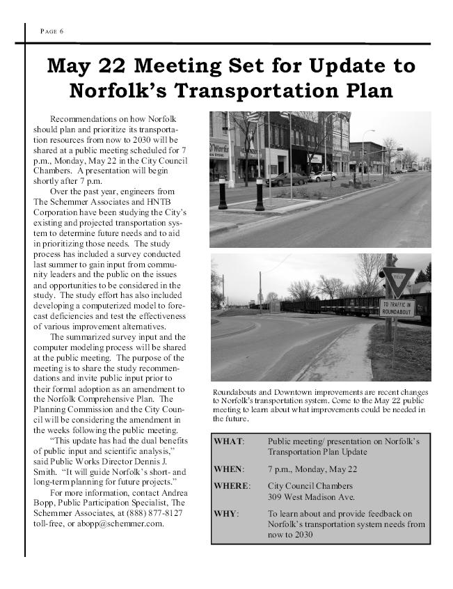
5 P AG E 6 City Seeks Public Input on Transportation System Plans &)*+,% How should Norfolk prioritize its limited transportation resources over the next one to 20 years? The City of Norfolk Public Works Department wants to hear your answers. Citizens are invited to provide their input on problems and opportunities related to Norfolk s streets, sidewalks, and trails by filling out a questionnaire. Citizens may find the questionnaire in this newsletter and electronically through the City Web site at The City will incorporate citizen input into the transportation section of the Norfolk Comprehensive Plan. This section of the Comprehensive Plan is being updated to incorporate a traffic analysis using a computerized model of Norfolk s transportation system. The information from the technology along with the input from the public will help us to better plan and prioritize the City s future needs, said Public Works Director Dennis Smith. Citizens may return written surveys by dropping them off at, or mailing them to, the main City office building, 127 N. First St., Norfolk, NE, 68701; or by faxing them to (402) A public meeting is planned for this fall to share the results of public input and the traffic analysis and to seek feedback on the preliminary recommendations. & ((#

6 NORFOLK TRANSPORTATION STUDY CITIZEN SURVEY The City of Norfolk needs your input on the future of its transportation system. Please take a few moments to fill out this survey, or you may fill out this survey electronically through the City Web site at Citizens may return written surveys by dropping them off at, or mailing them to, the main City office building, 127 N. First St., Norfolk, NE, 68701; or by faxing them to (402) Thank you for your input! 1. Norfolk s transportation system affects your quality of life. How would you rate each of the following on a scale of 1 to 5 with 1 being Unacceptable/Very Poor and 5 being Acceptable/Very Good. Congestion on major streets Condition of major streets & roadways Travel times between places you go Public transit system (Handi Bus) Street maintenance & repair Condition & availability of sidewalks Condition, availability & connectivity of trails If someone asked you to prepare a plan for Norfolk s transportation system, what are the top three actions or projects you would most strongly recommend? 3. If you could change one thing about transportation in Norfolk, what would you change? 4. What is the best thing about transportation in Norfolk? 1
7 5. How would you rate your satisfaction with the following aspects of Norfolk s transportation system? Roads/Streets Very Satisfied Okay Dissatisfied Sidewalks Very Satisfied Okay Dissatisfied Intersections Very Satisfied Okay Dissatisfied Handi Bus Routes Very Satisfied Okay Dissatisfied Highway System Very Satisfied Okay Dissatisfied Bike Paths Very Satisfied Okay Dissatisfied Trails Very Satisfied Okay Dissatisfied 6. What would you feel should be emphasized in the Comprehensive Plan Update regarding transportation? Please rate each of the following using a scale of 1 to 5, where 1 means it should have very little emphasis at all and 5 means the item should be strongly emphasized. Planning for widening roads Planning for ongoing maintenance and preservation of streets & highways Planning for new interchanges and new roads to respond to future growth Planning for safety & traffic flow improvements at intersections Planning for more bicycle paths and trails Improving bicyclist & pedestrian safety Investigate more public transit alternatives Please provide any additional comments here: You re your name and mailing address (if you would like to be informed of meetings and other information related to this effort): 2
8 CITY OF NORFOLK TRANSPORTATION PLAN UPDATE PUBLIC INPUT SURVEY RESULTS
9 1. Norfolk's transportation system affects your quality of life. How would you rate the following on a scale of 1 to 5 being with 1 being Unacceptable/Very Poor and 5 being "Acceptable/Very Good." Norfolk Comprehensive Plan Survey Results (Public Input) Poor Excellent Congestion on major streets 3.43 Condition of major streets & roadways 3.26 Travel times between places you go 3.80 Public transit system (Handi Bus) 2.92 Street maintenance & repair 2.87 Condition & availability of sidewalks 2.69 Condition, availability & connection of trails 3.20 Public Input Survey Results
10 2. If someone asked you to prepare a plan for Norfolk's transportation system, what are the top three actions or projects you would most strongly recommend? Bypass Highway 81 bypass (3) Bypass around Norfolk (3) Cleanliness and Maintained Trim trees/bushes that block visibility at intersections (3) Clean up streets and sidewalks Intersection Improvements Coordination of traffic signals (4) Install adequate number of turn arrows for the amount of turn lanes - 1st & Omaha, 1st & Pasewalk, 1st & Madison, 1st & Norfolk, 13th & Michigan (3) Need more dual turn lanes on busy streets (2) Traffic signal at Park & 1st Street Parking Parking near trail access (east end of town)* Go back to parallel parking on Norfolk Ave. Widen diagonals Queen City Blvd Planning/Public Awareness Plan for more usage of bicycles & motor scooters Improve public awareness regarding street closings Post dead-end signs where needed* Continue re-work of existing streets and planning of future roads Sidewalks Repair sidewalks (8) Add more sidewalks (8) Increase bicyclist & pedestrian safety Sidewalk east of BelAir School Sidewalks - North 13th (Hwy 81), North of Benjamin, East Norfolk, & Victory Road Street Maintenance/Improvements/Changes Repair the streets and roadways (17) No more round-abouts (4) Redo N. 25th Street (3) Streets that line up with existing streets (2) Resurface Michigan Ave. (2) Paved all unpaved streets in city limits Remove median on Norfolk Ave. More one-way streets Make Hwy 81 & 1st Street one way No through traffic on Norfolk Ave on 1st to 6 th Accidents at 275 & Pasewalk Putting speed bumps in where needed Service alleys behind houses Traffic at 1st & Madison Make downtown like 3rd Street in Yankton Eliminate one-way streets Post dead-end signs where needed* Fix Riverside & Benjamin; 1st Street & Braasch Ave. Public Survey Results * - indicates item listed under more than one category
11 Finishing widening Benjamin Ave. to Hwy 35 Repair track crossing at Philip & Park Ave. Turn Norfolk Ave into 4 lane Fix dip at 25th & Norfolk Ave Better run-off alternatives for residential streets Traffic Enforcement/Management Enforce red light runners (4) Better traffic management at schools (4) Red light cameras (3) More round-abouts (2) Give tickets to motorists talking on cell phones More enforcement of speed limits Reducing speed limits Enforce seatbelt law Enforce use of sidewalks Enforce parking restrictions Slow down north/south traffic on 13th Street from Elm to Benjamin Slow down traffic on one-ways Remove trucks from residential streets Trails Create/connect more trails (9) Keep up trails (2) Trail along Elkhorn River to connect with Levee trail south of Norfolk Parking near trail access (east end of town)* Trains Have trains go through in late evening or early morning (2) Transportation System Public bus system (20) Provide transportation for the elderly (3) Need more buses City cannot support public transit system - keep Handi Bus Public Survey Results * - indicates item listed under more than one category
12 3. If you could change one thing about transportation in Norfolk, what would you change? Bypass Bypass around Norfolk (4) Change 13th Street to bypass Cleanliness and Maintained Get rid of odor on Norfolk Ave in business district Intersection Improvements Return to 4-way stops (instead of round-abouts) (8) 13th & Omaha Ave. - busy intersection (2) Stop-lights in more places - count-down signals for pedestrians Need wider right turn lanes on Benjamin to Hillview & Norfolk to 4th Street Need right-turn only lanes - especially Benjamin & 13th; 13th & Omaha Ave. Parking Parallel parking downtown (6) No through traffic downtown - make more ped friendly and easier to get out of parking* Street Maintenance/Improvements/Changes Repair and maintain streets (4) N. 1st Street - a lot of traffic Get rid of one-way streets on 3rd - 6th Streets Traffic flow on Hwy 81 Make Victory Road, Eisenhower Road & Nucor Road four lanes Remove islands downtown No through traffic downtown - make more ped friendly and easier to get out of parking* Traffic Enforcement/Management Traffic speed through residential areas (2) Better traffic enforcement (2) Seatbelts law in all vehicles Trains Train at noon and 5 p.m. Transportation System Public bus system (14) Add something like Ollie the Trolley (2) Better cab company (2) Public bus system is very limited - hours & accessibility - is it really for the public? 24-hour taxi service Public Survey Results * - indicates item listed under more than one category
13 4. What is the best thing about transportation in Norfolk? Intersection Improvements New round-abouts (13) Left turn signals at 13th & Benjamin Traffic light at Benjamin & Hillview Signal timings Other Misc. Short travel times (27) Walking and biking trails Fast snow removal on streets Traffic that brings business to Norfolk Fire and Rescue Service Good and courteous drivers The City's progress City is wiling to get input from public Street Maintenance/Improvements/Changes Street maintenance (5) Widening of Benjamin Ave. (3) Transportation System Handi Bus (5) Cab service Public Survey Results * - indicates item listed under more than one category
14 5. How would you rate your satisfaction with the following aspects of Norfolk's transportation system? Road/Streets Sidewalks 22% 23% 20% Very Satisfied Okay Dissatisfied 34% Very Satisfied Okay Dissatisfied 55% 46% Intersections Handi Bus Routes 23% 18% 26% 12% Very Satisfied Okay Dissatisfied Very Satisfied Okay Dissatisfied 59% 62%
15 5. How would you rate your satisfaction with the following aspects of Norfolk's transportation system? Highway System Bike Paths 11% 35% Very Satisfied Okay Dissatisfied 21% 28% Very Satisfied Okay Dissatisfied 54% 51% Trails 19% 29% Very Satisfied Okay Dissatisfied 52%
16 6. What would you feel should be emphasized in the Comprehensive Plan Update regarding transportation? Please rate each of the following using a scale of 1 to 5, where 1 means it should have very little emphasis at all and 5 means the item should be strongly emphasized. Comp Plan Emphasis (Public Input) Investigate more public transit alternatives Improving bicyclist and pedestrian safety Planning for more bicycle paths and trails 2.65 Planning for safety and traffic flow improvements at intersections 3.79 Planning for new interchanges and new roads to respond to future growth Planning for ongoing maintenance and preservation fo streets and highways Planning for widening roads Public Input Survey Results
17 7. Additional Comments: Bypass Development around the 275 bypass has Truck bypass route needed Need bypass around town Cleanliness and Maintained City needs to trim trees/bushes that they planted (2) Property owners fined if sidewalks not cleared within allotted time* Streets need to cleared in more timely manner Intersection Improvements Traffic light at Riverside & Benjamin only turns green for cars in intersection, not for cars traveling opposite direction Michigan & 13th, Norfolk & 1st, Omaha & 1st need 4 way arrows Intersection of N. 1st & E. Klug is dangerous Round-abouts are great Stop sign on 4th Street between Omaha & Pasewalk Round-abouts have improved traffic flow Planning/Public Awareness Need better knowledge & policing of round-abouts Other Misc. Keep up good work Sidewalks Sidewalk need maintained - curbs & ramps Property owners fined if sidewalks not cleared within allotted time* Additional sidewalks - especially south of Meadow to Pasewalk Sidewalk between 10th & 11th Streets is horrible on Phillip Ave. Need sidewalks on Pennsylvania Ave. Sidewalks bad on South 5th Street More sidewalks Street Maintenance/Improvements/Changes Need to repair side streets (2) Severe slope of ramps - especially Braasch & Norfolk Ave. Streets are bad - need overlay and too narrow Need 4 lanes on all highways to Yankton, Sioux City & West 275 Concerned of street layout and limited access regarding development in northwest Norfolk Divots has terrible traffic problems Benjamin Ave. west of 25th - Fire Station Traffic on Hwy 81 is becoming unbearable Pave all city streets Public Survey Results * - indicates item listed under more than one category
18 Make streets around schools one-way - to get in and out quickly Transportation System Improve Handi Bus and cab company wait times Need to support railway more & bus transportation Trails More trails Water park Do not need a water park (4) More study on water park Water park should not go at 1st & Benjamin Public Survey Results * - indicates item listed under more than one category

19 CITY OF NORFOLK TRANSPORTATION PLAN UPDATE STAKEHOLDER SURVEY RESULTS
20 1. Norfolk's transportation system affects your quality of life. How would you rate the following on a scale of 1 to 5 being with 1 being Unacceptable/Very Poor and 5 being "Acceptable/Very Good." Norfolk Comprehensive Plan Survey Results (Stakeholder Interviews) Poor Excellent Congestion on major streets 3.47 Condition of major streets & roadways 3.53 Travel times between places you go 3.97 Public transit system (Handi Bus) 2.73 Street maintenance & repair 3.41 Condition & availability of sidewalks 2.88 Condition, availability & connection of trails 3.26 Stakeholder Survey Results
21 2. If someone asked you to prepare a plan for Norfolk's transportation system, what are the top three actions or projects you would most strongly recommend? Bypass Possible Hwy 81 bypass (4) Hwy 35 as four-lane expressway with bypass to Hwy 81 southeast (3) Explore future bypass routes for Hwy 275, 81 and 35 (2) Truck Route established (2) Beltway around Norfolk (2) Continue expressway construction on Hwy 81, 275 and 35. A north-south bypass Hwy 35 bypass to Sioux City Bypass to divert truck traffic Cleanliness and Maintained Improve presentation of the city when entering from any direction Landscaping with street improvements* Intersection Improvements Riverside and Benjamin intersection Hwy 81 & 275 intersection congestion Affiliated Foods inbound/outbound traffic Omaha Ave & 275 intersection Change access to state-run highways so the lights don't control city traffic Locations and need for additional traffic signals Sidewalks Sidewalks to schools and parks (2) Need sidewalks where there aren't any Sidewalk on South 25th Street to Wal-Mart Sidewalk - west on 25th on Benjamin Sidewalk along Pasewalk Street Maintenance/Improvements/Changes 25th & 37th streets improvements (6) Relocation of Nucor Road (2) Benjamin - 1st to 13th 7th Street - Madison to Prospect Pasewalk island east side new US 275 Do away with three-lane streets Access from north Hwy 81 to Nucor; Norfolk Iron & Metal; and proposed ethanol plant Overall street repair Building infrastructure - northwest of town Improve traffic access to industries at Hwy 81 & Hwy 275 Complete four-lane infrastructure Continue 25th development south at Benjamin Georgia St. - south of middle school Stakeholder Survey Results * - indicates item listed under more than one category
22 18th Street by Westside Benjamin - west of 25th Street Victory Road Improvement 37th St. w/ Parkway on NW Norfolk Improve Norfolk Ave Landscaping with street improvements* Make more four-lane roadways in Norfolk Connect more four-lane roads to area towns Another East-West arterial Reconstruct Victory Road north Eisenhower St. improvements Oak Street Project Pave roads in Skyview park Traffic Enforcement/Management More traffic control in residential areas Maintain good traffic flow Semi truck traffic Traffic around schools Trails Better trail system Keep improving trails Trains Improve rail system* Reschedule Nucor Train Transportation System Commercial air service (2) Public Transportation System needed (2) Need airport shuttle to Omaha Maintaining Handi Bus Improve rail system* Transportation for Elderly improvements Stakeholder Survey Results * - indicates item listed under more than one category
23 3. If you could change one thing about transportation in Norfolk, what would you change? Bypass Remove truck traffic off city streets (2) Maybe implement bypass Bypass with all direction access Bypass for Hwy 81 Bypass 81/35/275 connection Remove one way streets or add N-S bypass* Cleanliness and Maintained Get rid of odor on Norfolk Ave in business district Intersection Improvements Traffic signal systems 13th & Hwy 81 Timing of signals Add more roundabouts Other Misc. Wouldn't change - just improve Increase funding Parking Parallel parking downtown (6) No through traffic downtown - make more ped friendly and easier to get out of parking* Street Maintenance/Improvements/Changes 25th needs to be 3 or 4 lanes Improve N-S and E-W through street availability Additional E-W arterial Remove one way streets or add N-S bypass* Improve quality of streets Traffic Enforcement/Management Traffic flow at peak hours Need better flow of traffic on Hwy 81 Trails Number of trails Transportation System Public transportation system (2) Improve transportation system for handicapped and elderly Expansion of time & location & use of Handi Bus Stakeholder Survey Results * - indicates item listed under more than one category
24 4. What is the best thing about transportation in Norfolk? Bypass Upgrades have been made to include the bypass Intersection Improvements Roundabouts (2) Street Maintenance/Improvements/Changes Condition/Maintenance of streets (8) Benjamin from 13th to 25th is greatly improved Most major roadways are 4 lane Hwy 275, 81 starting to integrate 4 lane Arterial streets have been improved to meet increased traffic demands Excellent interior major streets and improvements (2) Traffic Enforcement/Management Traffic flow and travel times are pretty good (15) Small number of cars compared to capacity Transportation System Handi Bus and cab system Trails Trail system is excellent (2) Stakeholder Survey Results * - indicates item listed under more than one category
25 5. How would you rate your satisfaction with the following aspects of Norfolk's transportation system? Road/Streets Sidewalks 20% 27% 35% Very Satisfied Okay Dissatisfied Very Satisfied Okay Dissatisfied 65% 53% Intersections Handi Bus Routes 6% 29% 21% 4% Very Satisfied Okay Dissatisfied Very Satisfied Okay Dissatisfied 65% 75%
26 5. How would you rate your satisfaction with the following aspects of Norfolk's transportation system? Highway System Bike Paths 19% 19% 13% Very Satisfied Okay Dissatisfied 37% Very Satisfied Okay Dissatisfied 62% 50% Trails 20% 20% Very Satisfied Okay Dissatisfied 60%
27 6. What would you feel should be emphasized in the Comprehensive Plan Update regarding transportation? Please rate each of the following using a scale of 1 to 5, where 1 means it should have very little emphasis at all 5 means the item should be strongly emphasized. Comp Plan Emphasis (Stakeholders) Investigate more public transit alternatives Improving bicyclist and pedestrian safety Planning for more bicycle paths and trails Planning for safety and traffic flow improvements at intersections Planning for new interchanges and new roads to respond to future growth Planning for ongoing maintenance and preservation of streets and highways Planning for widening roads Stakeholder Survey Results
28 7. Additional Comments: Bypass Plan for bypass Bypass around east side seems to be a priority. Intersection Improvements Traffic control for intersections, stop signs, and lights Traffic Enforcement/Management Study rush hour traffic Transportation System Currently there is only private transport. Norfolk needs a public transportation system and current street planning must plan and facilitate public transport. The Handi bus is not public and cannot handle large numbers Other/Misc. Thanks for looking into future transportation needs Good job at keeping up with need/changes Thanks Stakeholder Survey Results * - indicates item listed under more than one category
VIII. Project Prioritization & Implementation
 Transportation Plan 2030 July 2006 VIII. Project Prioritization & Implementation Public Transit Service Investigation into the development of a demand responsive service route system through a process
Non-Motorized Transportation 7-1
 Non-Motorized Transportation 7-1 Transportation facilities no longer mean just accommodating a vehicle powered by a combustion engine. Pedestrian and non-motorized facilities are important modes of travel
TRASBURG RANSPORTATION
 TRASBURG RANSPORTATION LAN DEVELOPED BY THE TRANSPORTATION PLANNING DIVISION OF THE VIRGINIA DEPARTMENT OF TRANSPORTATION IN COOPERATION WITH THE U.S. DEPARTMENT OF TRANSPORTATION, FEDERAL HIGHWAY ADMINISTRATION
Tonight is for you. Learn everything you can. Share all your ideas.
 Strathcona Neighbourhood Renewal Draft Concept Design Tonight is for you. Learn everything you can. Share all your ideas. What is Neighbourhood Renewal? Creating a design with you for your neighbourhood.
Thank you for attending
 Improving mobility safety comfort WELCOME Thank you for attending The purpose of this meeting is to: Learn about the project Prioritize potential walking and biking improvements on Snelling Ave Gather
ARTINSVILLE ENRY OUNTY REA RANSPORTATION TUDY
 ARTINSVILLE ENRY OUNTY REA RANSPORTATION TUDY DEVELOPED BY THE TRANSPORTATION AND MOBILITY PLANNING DIVISION OF THE VIRGINIA DEPARTMENT OF TRANSPORTATION IN COOPERATION WITH THE U.S. DEPARTMENT OF TRANSPORTATION,
BETHEL ROAD AND SEDGWICK ROAD CORRIDOR STUDY
 DRAFT PLAN City Council Meeting August 14, 2017 STUDY AREA Sedgwick Corridor State Route 160, principal arterial with Class 3 access management designation, commuter and freight route, connection to SR
Lee s Summit Road Improvement Study Public Open House June 7, 2007 Summary of Comment Card Responses
 Lee s Summit Road Improvement Study Public Open House June 7, 2007 Summary of Comment Card Responses Introduction At the Lee s Summit Road Improvement Study Public Open House held Thursday, June 7, 2007
Community Task Force November 15, 2017
 Community Task Force November 15, 2017 Welcome and Introductions Project Partners Regional Transportation District (RTD) Colorado Department of Transportation (CDOT) Denver Regional Council of Governments
Solana Beach Comprehensive Active Transportation Strategy (CATS)
") Solana Beach Comprehensive Active Transportation Strategy (CATS) 3.0 Goals & Policies The Solana Beach CATS goals and objectives outlined below were largely drawn from the Solana Beach Circulation Element
Solana Beach Comprehensive Active Transportation Strategy (CATS) 3.0 Goals & Policies The Solana Beach CATS goals and objectives outlined below were largely drawn from the Solana Beach Circulation Element
INTERMODAL TRANSPORTATION PLAN
 INTRODUCTION INTERMODAL TRANSPORTATION PLAN Effective intermodal transportation implies a public policy for actively decreasing the demand for automobile trips and consequently reducing automobile related
12 RECOMMENDATIONS Road Improvements. Short Term (generally the next five years)
") 12 RECOMMENDATIONS Recommendations are based on the technical analysis of existing and future road and active transportation conditions, the results of the review of existing City policies and public feedback.
12 RECOMMENDATIONS Recommendations are based on the technical analysis of existing and future road and active transportation conditions, the results of the review of existing City policies and public feedback.
122 Avenue: 107 Street to Fort Road
 : 107 Street to Fort Road November 24, 2015 4:30 8:00 p.m. Meeting Purpose Summarize project work completed to date Share results of public input from Phase 1 Share the draft concept plan and proposed
City of Davis East Covell Corridor Plan
 Community Open House #2 January 22, 2014 6:00 8:00 p.m. Veterans Memorial Center, Club Room City of Davis Introduction The (ECCP) is a taking a comprehensive look at the existing transportation systems
Bicycle Master Plan Goals, Strategies, and Policies
 Bicycle Master Plan Goals, Strategies, and Policies Mobilizing 5 This chapter outlines the overarching goals, action statements, and action items Long Beach will take in order to achieve its vision of
Outreach Approach RENEW SF served as the primary liaison with the North Beach community; the Chinatown. Executive Summary
 Executive Summary Executive Summary The Columbus Avenue Neighborhood Transportation Study s objective is to identify changes to transportation infrastructure and policies that could enhance the livability
EXECUTIVE SUMMARY. Vision
 Vision Walking and bicycling in Salt Lake City will be safe, convenient, comfortable, and viable transportation options that connect people to places, foster recreational and economic development opportunities,
2011 Capital Projects University Area - Community Council Priority List Municipality of Anchorage
 2011 Capital Projects University Area - Community Council Priority List Municipality of Anchorage 2 Project Management and Engineering Projects on 40th Ave Extension - Lake Otis Pkwy to Dale St $18,103,000
City of Gainesville Transportation/Roadway Needs PROJECT SUMMARY
 A1 Roadway Resurfacing $23,846,000 TYPE: Preservation of existing system Roadway resurfacing A2 Signal Replacement $6,000,000 TYPE: Preservation of existing system Replace traffic signals. B1 W 6th St
City of Sammamish. Welcome. Issaquah-Fall City Road Improvements Project Phase I Design: 242nd Avenue SE to Klahanie Drive SE
 Welcome Welcome to the third community meeting for the Issaquah-Fall City Road Improvements Project. AGENDA 6:00 p.m. Welcome and sign-in 6:10 p.m. Presentation 6:50 p.m. Open house Learn about the roadway
Mineral Avenue Corridor Assessment. ITE 2017 Western District Annual Meeting San Diego, CA June 21 st
 Mineral Avenue Corridor Assessment ITE 2017 Western District Annual Meeting San Diego, CA June 21 st Biography - Aaron Heumann, PE, PTOE Currently City of Littleton Transportation Engineering Manager 24
5. RUNNINGWAY GUIDELINES
 5. RUNNINGWAY GUIDELINES These guidelines should be considered collectively when making runningway decisions. A runningway is the linear component of the transit system that forms the right-of-way reserved
Welcome. Thank you for your interest in the Lewis & Clark Viaduct Concept Study
 Welcome Thank you for your interest in the Lewis & Clark Viaduct Concept Study Please use the arrows in the upper left hand corner to navigate through the presentation. Use the envelope icon to ask a question
Pine Hills Road Pedestrian/Bicycle Safety Study Board of County Commissioners Work Session
 Pine Hills Road Pedestrian/Bicycle Safety Study Board of County Commissioners Work Session February 20, 2018 Meeting Agenda Study Overview Existing Conditions Access Management Potential Gateway Features
What Is a Complete Street?
 Session 5 Charleen Zimmer, AICP, Zan Associates May 5-7, 2010 What Is a Complete Street? May 2010 5-1 Not a Complete Street More of a Complete Street May 2010 5-2 Benefits of Complete Streets Safety for
Safe Routes to School Action Plan Aberdeen, Idaho
 Background Aberdeen, Idaho is a largely agricultural community of nearly 2,000 people and is located in the southeast portion of the state on the western edge of American Falls Reservoir. The community
Commerce Street Complete Street Project from Good Latimer Expressway to Exposition Avenue
 Commerce Street Complete Street Project from Good Latimer Expressway to Exposition Avenue T A N Y A B R O O K S A S S I S T A N T D I R E C T O R M O B I L I T Y P L A N N I N G M O B I L I T Y A N D S
TRANSPORTATION TRAINING TOPICS. April 6, 2010
 TRANSPORTATION TRAINING TOPICS April 6, 2010 Roles of Transportation Providers Context and Policy Makers Division of Transportation and Traffic Other City Operations Other Transportation Operators CMA
Riverside Drive Complete Streets Project 3 rd Community Meeting. March 26, 2015
 Riverside Drive Complete Streets Project 3 rd Community Meeting March 26, 2015 Providing Feedback Sign-In with contact information for future updates Complete questionnaire provided tonight Complete comment
MINERAL AVENUE CORRIDOR ASSESSMENT STUDY IMPLEMENTATION STRATEGY
 MINERAL AVENUE CORRIDOR ASSESSMENT STUDY IMPLEMENTATION STRATEGY INTRODUCTION City Personnel Sign-in Sheet Comment Forms Please Write Down Any Feedback INTRODUCTION List of Topics for Presentation Study
AGENDA REPORT. Issue: Discussion of potential improvements on Barnwell Road at Niblick Drive
 AGENDA REPORT To: From: By: Honorable Mayor and City Council Members Warren Hutmacher, City Manager Tom Black, Public Works Director Date: March 23, 2016 Agenda: March 28, 2016 WORK SESSION AGENDA: Barnwell
UPTOWN REGIONAL BIKE CORRIDORS PROJECT SAN DIEGO ASSOCIATION OF GOVERNMENTS
 UPTOWN REGIONAL BIKE CORRIDORS PROJECT SAN DIEGO ASSOCIATION OF GOVERNMENTS SUMMARY REPORT: COMMUNITY UPDATE MEETING February 6, 2014 6 8:30 p.m. Roosevelt Middle School Library 3366 Park Blvd, San Diego
Circulation in Elk Grove includes: Motor vehicles, including cars and trucks
 Circulation, as it is used in this General Plan, refers to the many ways people and goods move from place to place in Elk Grove and the region. Circulation in Elk Grove includes: Motor vehicles, including
DRAFT BUENA VISTA 2020 TRANSPORTATION PLAN
 DRAFT BUENA VISTA 2020 TRANSPORTATION PLAN DEVELOPED BY THE TRANSPORTATION PLANNING DIVISION OF THE VIRGINIA DEPARTMENT OF TRANSPORTATION IN COOPERATION WITH THE U.S. DEPARTMENT OF TRANSPORTATION, FEDERAL
Attachment One. Integration of Performance Measures Into the Bryan/College Station MPO FY 2019 FY 2022 Transportation Improvement Program
 Attachment One Integration of Performance Measures Into the Bryan/College Station MPO FY 2019 FY 2022 Transportation Improvement Program Introduction Begun as part of the Moving Ahead for Progress in the
Route 29 Solutions Projects
 Route 29 Solutions Route 29 Solutions Projects www.route29solutions.org October 10, 2014 Route 29 Widening to Six Lanes Albemarle County This project will widen a 1.8-mile segment of Route 29 from four
TRANSPORTATION & MOBILITY
 TRANSPORTATION & MOBILITY ROADWAY SYSTEM There are approximately 40 miles of roadways in Manitou Springs. For planning purposes, roadways are typically assigned a functional classification which defines
WELCOME! Please complete a comment sheet as we value your feedback. 4 pm to 8 pm. September 15, Hosted by: AECOM on behalf of City of Calgary
 WELCOME! Thank you for attending our open house. There will be no formal presentation today so please take the time to read the boards. If you have any questions, please do not hesitate to approach one
Building Great Neighbourhoods QUEEN ALEXANDRA
 Building Great Neighbourhoods QUEEN ALEXANDRA We are here today to Explain how the City is investing in improving your neighbourhood and how your neighbourhood will be improved to meet current City standards.
RZC Appendix 8A Marymoor Subarea Street Requirements
 RZC Appendix 8A Marymoor Subarea Street Requirements For additional design details for Marymoor Subarea infrastructure, refer to the 2017 Marymoor Subarea Infrastructure Planning Report. STREET REQUIREMENTS
WELCOME. Stakeholder Involvement Group Meeting #2 Round Lake Public Works October 24, 2018
 WELCOME Stakeholder Involvement Group Meeting #2 Round Lake Public Works October 24, 2018 MEETING AGENDA 1. Welcome and Introductions 2. Study Progress Update 3. Problem Statement 4. Technical Analysis
Technical Working Group November 15, 2017
 Technical Working Group November 15, 2017 Welcome and Introductions Project Partners Regional Transportation District (RTD) Colorado Department of Transportation (CDOT) Denver Regional Council of Governments
Living Streets Policy
 Living Streets Policy Introduction Living streets balance the needs of motorists, bicyclists, pedestrians and transit riders in ways that promote safety and convenience, enhance community identity, create
Memorandum. Sunday, July 13, Saturday, July 19, 2014
 Memorandum To: David Lowin, Brooklyn Bridge Park Corporation From: Daniel Schack, AICP, PTP Date: Re: Brooklyn Bridge Park Pier 5/6 Loop Road Traffic Study Project No: 14-01-2407 At the request of Brooklyn
Environmental Assessment Findings & Recommendations. Public Hearing November 13, 2014
 Environmental Assessment Findings & Recommendations Public Hearing November 13, 2014 Welcome! Welcome and Introductions Project and Environmental Assessment Overview Public Comments Adjourn Purpose of
Chapter 7. Transportation. Transportation Road Network Plan Transit Cyclists Pedestrians Multi-Use and Equestrian Trails
 Chapter 7 Transportation Transportation Road Network Plan Transit Cyclists Pedestrians Multi-Use and Equestrian Trails 7.1 TRANSPORTATION BACKGROUND The District of Maple Ridge faces a number of unique
ECONOMY PEOPLE ENVIRONMENT
 Report Back on Local Transit Improvements May 29, 2013 ECONOMY PEOPLE ENVIRONMENT Intro Council Requested Report Back Topics Progress on Planning for Broadway Subway False Creek Bridges Local Transit Improvements
Paoli Road Improvement Feasibility Study
 Paoli Road Improvement Feasibility Study & Public Participation Project March 24, 2015 Prepared for: Tredyffrin Township Prepared by: McMahon Associates, Inc. with Town Planning Partnership, LLC Glackin
TRAFFIC CALMING GUIDE FOR TORONTO CITY OF TORONTO TRANSPORTATION SERVICES DIVISION
 TRAFFIC CALMING GUIDE FOR TORONTO CITY OF TORONTO TRANSPORTATION SERVICES DIVISION CITY OF TORONTO TRANSPORTATION SERVICES DIVISION 2016 TRAFFIC CALMING GUIDE FOR TORONTO TABLE OF CONTENTS Introduction
US 20 Feasibility Study. Village Board Meeting. Shales Parkway to IL Route 390 IL Route 390 Extension (North Ave to US 20)
") US 20 Feasibility Study Shales Parkway to IL Route 390 IL Route 390 Extension (North Ave to US 20) Village Board Meeting Bartlett Village Hall February 16, 2016 1 Background 1991 IDOT Study Recommendations
US 20 Feasibility Study Shales Parkway to IL Route 390 IL Route 390 Extension (North Ave to US 20) Village Board Meeting Bartlett Village Hall February 16, 2016 1 Background 1991 IDOT Study Recommendations
NORTHERN VIRGINIA HIGHLIGHTS for the Dulles Area Transportation Association
 NORTHERN VIRGINIA HIGHLIGHTS for the Dulles Area Transportation Association June 20, 2012 Garrett Moore VDOT District Administrator, Northern Virginia Paving Program 2012 This season's paving program will
I 10 Phoenix to California Border Multimodal Corridor Profile Study
 I 10 Phoenix to California Border Multimodal Corridor Profile Study December 2012 Prepared by Arizona Department of Transportation 206 S. 17th Ave. Phoenix, AZ 85007 In cooperation with U.S. Department
In station areas, new pedestrian links can increase network connectivity and provide direct access to stations.
 The Last Mile Planning for Pedestrians Planning around stations will put pedestrians first. Making walking to stations safe and easy is important; walking will be a part of every rapid transit Accessible
Municipal Class EA To Address Traffic Congestion On The Ontario Street Corridor (Grand Bend) Public Information Meeting June 4, 2018
 Public Information Meeting June 4, 2018") Municipal Class EA To Address Traffic Congestion On The Ontario Street Corridor (Grand Bend) Public Information Meeting June 4, 2018 Background Agenda Traffic Study Update Class EA Alternatives Bridge
Municipal Class EA To Address Traffic Congestion On The Ontario Street Corridor (Grand Bend) Public Information Meeting June 4, 2018 Background Agenda Traffic Study Update Class EA Alternatives Bridge
Transportation Planning Division
 Transportation Planning Division Presentation Outline Study Tasks Recap of Previous Meetings Data Collected Focus Areas within Study Limits Design Principles Tool Box Recommended Concepts Schedule Moving
2018 Transportation Survey October 17, Prepared by:
 Transportation Survey October 17, Prepared by: Overview Methodology Systemwide results Strengths/Weaknesses by mode Importance of possible improvements Conclusions Methodology 500 Chittenden County residents
San Jose Transportation Policy
 San Jose Transportation Policy Protected Intersections in LOS Policies to Support Smart Growth Presented by: Manuel Pineda City of San Jose Department of Transportation Bay Area Map San Francisco Oakland
Bikeway action plan. Bicycle Friendly Community Workshop March 5, 2007 Rochester, MN
 Bikeway action plan Summary The was held on March 5, 2007 at the Rochester Mayo Civic Center. The workshop was hosted by Rochester-Olmsted County Planning Department in collaboration with the League of
Duwamish Way-finding and CTR Report
 V. North Tukwila When the North Tukwila Manufacturing and Industrial Center was designated in 1992 as part of the region s land use and transportation plan, the plan called for the area to set a light-rail
25th Avenue Road Diet Project A One Year Evaluation. Transportation Fund for Clean Air Project #05R07
 25th Avenue Road Diet Project A One Year Evaluation Transportation Fund for Clean Air Project #05R07 Submitted by: The San Francisco Municipal Transportation Agency Dan Provence May 22, 2009 EXECUTIVE
APPENDIX 2 LAKESHORE ROAD TRANSPORTATION REVIEW STUDY EXECUTIVE SUMMARY
 APPENDIX 2 LAKESHORE ROAD TRANSPORTATION REVIEW STUDY EXECUTIVE SUMMARY Appendix 2 City of Mississauga Lakeshore Road FINAL REPORT Transportation Review Study December 2010 EXECUTIVE SUMMARY Study Purpose
Bluffdale/ UDOT South High-T Intersection Project Type Operations
 Bluffdale/ UDOT 14600 South High-T Intersection Project Type Operations 14600 South and Redwood Road $ 600,000 $ 550,000 This project is to install a new High-T intersection at Redwood Road and 14600 South
Section 2: Importance-Satisfaction Analysis
 Section 2: Importance- Analysis ETC Institute (2009) 35 Overview Importance- Analysis Blue Springs, MO Today, city officials have limited resources which need to be targeted to activities that are of the
City of Birmingham Draft Multi-modal Transportation Plan
 City of Birmingham Draft Multi-modal Transportation Plan City Commission Public Hearing Monday, November 25, 2013 7:30 pm Norman Cox, PLA, ASLA The Greenway Collaborative, Inc. Ann Arbor, Michigan The
Bicycle and Pedestrian Plans and Improvements
 Bicycle and Pedestrian Plans and Improvements Presented to the City Council By Randle Harwood, Planning and Development, and Richard Zavala, Parks and Community Services September 24, 2013 Purpose Review
APPENDIX D. May 22, 2002 Open House Summary and Materials
 APPENDIX D May 22, 2002 Open House Summary and Materials TH 36 Partnership Study Open House May 22, 2002 Summary of Survey Responses 1. If no new crossing of the St. Croix River is built (e.g. the existing
WELCOME. Thank you for joining us at the Second Public Workshop for the Carlsbad Pedestrian Master Plan. We look forward to receiving your feedback.
 City of Carlsbad Pedestrian Master Plan: WELCOME WELCOME Please Sign In Provide Input at Flip Charts Review Boards Presentation of Draft Plan Thank you for joining us at the Second Public Workshop for
New Measure A Expenditure Categories DEFINITIONS OF ELIGIBLE EXPENDITURES Adopted March 8, 2007
 New Measure A Expenditure Categories DEFINITIONS OF ELIGIBLE EXPENDITURES Adopted March 8, 2007 City Street and County Road Maintenance Program The preservation and keeping of public street and road rights-of-way
Memo. Ocean Avenue Corridor Design Project Public Workshop #2 Summary
 Ocean Avenue Corridor Design Project Public Workshop #2 Summary The second public workshop for the Ocean Avenue Corridor Design Project was held on Wednesday, May 14, 2014 from, 6 to 8 pm at Lick Wilmerding
Basalt Creek Transportation Refinement Plan Recommendations
 Basalt Creek Transportation Refinement Plan Recommendations Introduction The Basalt Creek transportation planning effort analyzed future transportation conditions and evaluated alternative strategies for
CITY OF SAINT JOHN TRAFFIC CALMING POLICY
 CITY OF SAINT JOHN TRAFFIC CALMING POLICY VERSION: 1.0 April 10, 2012 Pedestrians, Cyclists and Motorists Sharing Street Spaces CONTENTS INTRODUCTION... 3 POLICY GOAL... 3 POLICY OBJECTIVES... 3 GUIDING
Orinda Bicycle, Trails and Walkways Master Plan
 Orinda Bicycle, Trails and Walkways Master Plan Public Meeting October 15, 2008 Presented by: Ian Moore, Alta Lauren Ledbetter, Alta Bruce Wolff, Alta Introductions City of Orinda Monica Pacheco, Assistant
CITY OF OTTAWA ROADWAY MODIFICATION APPROVAL UNDER DELEGATED AUTHORITY
 RMA-2015-ATM-038 CITY OF OTTAWA ROADWAY MODIFICATION APPROVAL UNDER DELEGATED AUTHORITY DATE: April 22, 2015 SUBJECT Approval of Roadway Modifications Recommended through an Area Traffic Management Study
Bay to Bay Boulevard Complete Streets Project
 Bay to Bay Boulevard Complete Streets Project Dale Mabry Highway to Bayshore Boulevard February 08, 2018 Photo Source: Tampa Bay Times Alessandra Da Pra Meeting Format Introduction Resurfacing Information
CITY OF COCOA BEACH 2025 COMPREHENSIVE PLAN. Section VIII Mobility Element Goals, Objectives, and Policies
 CITY OF COCOA BEACH 2025 COMPREHENSIVE PLAN Section VIII Mobility Element Goals, Objectives, and Policies Adopted August 6, 2015 by Ordinance No. 1591 VIII MOBILITY ELEMENT Table of Contents Page Number
MASTER BICYCLE AND PEDESTRIAN PLAN
 VILLAGE OF NORTHBROOK MASTER BICYCLE AND PEDESTRIAN PLAN DRAFT PLAN OPEN HOUSE May 2, 2018 AGENDA 1. Community Engagement 2. Vision and Goals 3. General Structure of Plan 4. Recommendations Overview 5.
MEMORANDUM. Earl Haugen and UND Transportation and Traffic Coordination Committee
 SRF No. 7766 MEMORANDUM TO: FROM: Earl Haugen and UND Transportation and Traffic Coordination Committee Rick Lane, P.E. DATE: November 26, 2013 SUBJECT: UNIVERSITY AVE REVIEW Our review of the University
City Birmingham Multi-Modal Transportation Plan Visioning Workshop Results Meeting
 City Birmingham Multi-Modal Transportation Plan Visioning Workshop Results Meeting Monday, January 28, 2013 7:30 PM, City Hall Norman Cox, PLA, ASLA. Ann Arbor, Michigan. www.greenwaycollab.com Community
Chapter 5. Complete Streets and Walkable Communities.
 Chapter 5. Complete Streets and Walkable Communities. 5.1 Description of Complete Streets. Cities throughout the world, and specifically the United States, are coming to embrace a new transportation and
Welcome to the Sellwood Bridge Project Open House!
 Welcome to the Sellwood Bridge Project Open House! 5:30 7:30 pm Please sign in here Information stations and project staff are located throughout the room. Goals for Tonight s Meeting: Learn how the Preferred
City of Seattle Edward B. Murray, Mayor
 City of Seattle Edward B. Murray, Mayor Department of Transportation Scott Kubly, Director Eastlake Community Council 117 E Louisa St. #1 Seattle, WA 98102-3278 January 28, 2016 RE: Roosevelt to Downtown
Draft North Industrial Area-Wide Traffic Plan
 Summary of North Industrial and Hudson Bay Industrial Recommended Improvements Table 1. Summary of s Item Location 1 2 3 4 5 6 7 8 9 10 11 12 Millar Ave north of 51st St Super 8 Motel back lane 400 Block
Brooklyn Boulevard (County Road 152) Reconstruction Project Phase I. OPEN HOUSE June 20, 2017
 Reconstruction Project Phase I. OPEN HOUSE June 20, 2017") Brooklyn Boulevard (County Road 152) Reconstruction Project Phase I OPEN HOUSE June 20, 2017 Brooklyn Boulevard (County Road 152) Phase I Project Partners Project Lead Other Project Partners include Brooklyn
Brooklyn Boulevard (County Road 152) Reconstruction Project Phase I OPEN HOUSE June 20, 2017 Brooklyn Boulevard (County Road 152) Phase I Project Partners Project Lead Other Project Partners include Brooklyn
HARRISON STREET/OAKLAND AVENUE COMMUNITY TRANSPORTATION PLAN
 HARRISON STREET/OAKLAND AVENUE Community Workshop #4: Draft Plan Review December 3, 2009 D E S I G N, C O M M U N I T Y & E N V I R O N M E N T INTRODUCTIONS Key Project Staff: Alisa Shen, Project Manager,
CITY OF CAMBRIDGE 2015 BICYCLE PLAN TOWARDS A BIKABLE FUTURE
 CITY OF CAMBRIDGE 2015 BICYCLE PLAN TOWARDS A BIKABLE FUTURE WHICH FUTURE? CAMBRIDGE MUNICIPAL POLICIES 1992: Vehicle Trip Reduction Ordinance 1998: Parking & Transportation Demand Ordinance 2002: Climate
Monroe Street Reconstruction
 Total participants: 45+ Monroe Street Reconstruction Cross Section Workshop Notes September 29, 2016, Wingra School Workshop Orientation, Technical and Functional Considerations: The workshop began with
Welcome! Thank you for joining us today for a Geary Rapid project open house. Geary Rapid Project. SFMTA.com/GearyRapid
 Welcome! Thank you for joining us today for a Geary Rapid project open house. Get the most out of this event: 1. Sign in and get your feedback sheet 2. Visit project information stations hosted by project
Proposed Bridge Street East Bicycle Lanes Public Open House Thursday, April 27, 2017
 WELCOME Proposed Bridge Street East Bicycle Lanes Public Open House Thursday, April 27, 2017 Purpose of the Open House The purpose of this Open House is to gain public input on the bicycle lanes proposed
Saskatchewan Drive Roadway Rehabilitation and Shared-Use Path Widening
 Saskatchewan Drive Roadway Rehabilitation and Shared-Use Path Widening We are here today to present the draft plan for the Saskatchewan Drive Roadway Rehabilitation and Shared-Use Path Widening project
Houma-Thibodaux Metropolitan Planning Organization STP<200K Funding Application APPLICATION
 APPLICATION HOUMA-THIBODAUX METROPOLITAN PLANNING ORGANIZATION (HTMPO) FOR SURFACE TRANSPORTATION PROGRAM (STP
PROJECT FACT SHEET May 25, 2018
 SITE CHALLENGES & PROJECT BACKGROUND In 2014, the City of Aspen identified the Castle Creek Bridge and Hallam Street corridor as a deficient link in Aspen s bicycle and pedestrian network. Safe and efficient
Kentucky s Surface Transportation System
 Kentucky s Surface Transportation System ROAD AND BRIDGE CONDITIONS, TRAFFIC SAFETY, TRAVEL TRENDS, AND NEEDS MARCH 2018 PREPARED BY WWW.TRIPNET.ORG Founded in 1971, TRIP of Washington, DC, is a nonprofit
Sherwood Drive Traffic Circle
 Strathcona County Sherwood Drive Traffic Circle Online Survey Results April 7, 215 I. Executive Summary The Sherwood Drive Traffic Circle Survey was administered in March 215. In total, 2,263 residents
Public Information Centre
 WELCOME Public Information Centre Father Tobin Road Lougheed Middle School - Library Wednesday November 7, 2012 7:00 p.m.to 9:00 p.m. Please sign in Neighbourhood Traffic Calming Guide Background The City
Road Diets FDOT Process
 Florida Department of TRANSPORTATION Road Diets FDOT Process Humberto Castillero, PE, PTOE Roadway Design Office Purpose of Guide Develop a statewide lane elimination review process Balance state & local
PRESS RELEASE San Joaquin Council of Governments
 PRESS RELEASE San Joaquin Council of Governments For Immediate Release February 23, 2018 Contact: Nicole Gorham, 235-0582 gorham@sjcog.org SJCOG Board Awards $19.63 Million in Measure K Bicycle, Pedestrian,
Chapter 5 Future Transportation
 Chapter 5 Future Transportation The Future Land Use Plan identifies the desired land use designations. The land uses desired for Crozet depend, in large part, on the success of the transportation system,
Appendix C. TRAFFIC CALMING PROGRAM TOOLBOX
 Appendix C. TRAFFIC CALMING PROGRAM TOOLBOX PHASE I...2 Do Not Enter Sign...3 One-Way Sign...4 Turn Prohibition...5 Pavement Markings...6 Speed Monitoring Trailer...7 Neighborhood Speed Watch...8 Police
Southview Blvd & 3 rd Avenue Improvement Project. Public Open House December 4, to 7pm
 Southview Blvd & 3 rd Avenue Improvement Project Public Open House December 4, 2014 5 to 7pm Southview Blvd & 3 rd Avenue Public Information Meeting Agenda Presentation 5:30 to 6:15 pm Purpose of Project
Houma-Thibodaux Metropolitan Planning Organization STP<200K Funding Application APPLICATION
 APPLICATION HOUMA-THIBODAUX METROPOLITAN PLANNING ORGANIZATION (HTMPO) FOR SURFACE TRANSPORTATION PROGRAM (STP