US 17 Business Corridor Study
|
|
|
- Allyson Cross
- 5 years ago
- Views:
Transcription


1 US 17 Business Corridor Study 3 rd Street to Covil Avenue Wilmington, NC STV / Ralph Whitehead Associates, Inc.
2 US 17 Business Corridor Study 3 rd Street to Covil Avenue Wilmington, NC April 2007 Prepared By: STV / Ralph Whitehead Associates, Inc Morehead Street, Suite 200 Charlotte, NC For: Wilmington MPO 305 Chestnut Street, 4 th Floor Wilmington, NC Brock LaForty, AICP Project Manager STV / Ralph Whitehead Associates, Inc. Mike Kozlosky Senior Transportation Planner City of Wilmington/Wilmington MPO
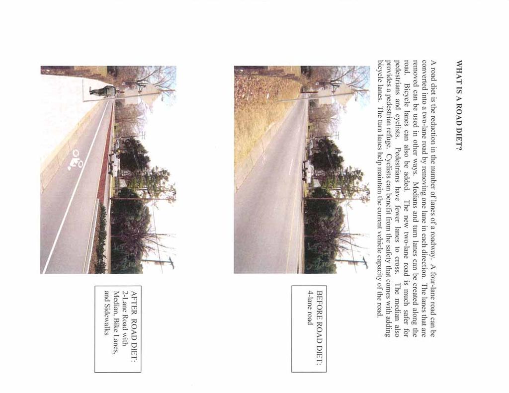
3 TABLE OF CONTENTS INTRODUCTION... 1 STUDY PURPOSE... 1 EXISTING CONDITIONS... 2 STUDY AREA... 2 ROADWAY GEOMETRY... 2 TRAFFIC...2 ACCIDENT DATA... 3 TRANSIT... 3 PARKS...4 CULTURAL RESOURCES... 4 BICYCLE AND PEDESTRIAN FACILITIES...4 ZONING AND LAND USE... 5 ADOPTED CORRIDOR AND LAND USE PLANS... 5 OTHER TRANSPORTATION IMPROVEMENT INITIATIVES... 5 PUBLIC INVOLVEMENT... 6 ALTERNATIVES... 7 ALTERNATIVES STUDIED... 7 ALTERNATIVES ELIMINATED...7 PREFERRED ALTERNATIVE...8 ESTIMATE...9 ACCESS MANAGEMENT INITIATIVES POLICY RECOMMENDATIONS ACCESS MANAGEMENT DESIGN ELEMENTS IMPLEMENTATION PLAN PROJECT PHASING...16 PROJECT FUNDING CONCLUSION Appendix A: Figures Appendix B: Traffic Analysis Summary Appendix C: Public Involvement Appendix D: Road Diet Information
 have given residents and visitors less congested, alternative routes to popular destinations in and beyond the city.")
4 Introduction The existing traffic patterns in and around the Wilmington area are changing. Several large projects, (I- 140/US 17 Bypass and Martin Luther King, Jr. Parkway) have given residents and visitors less congested, alternative routes to popular destinations in and beyond the city. Other proposed transportation initiatives will continue to provide a multitude of options for travelers and residents. Recognizing this shift, the City of Wilmington and the Wilmington Metropolitan Planning Organization (WMPO) felt that a fresh look at the US 17 Business Corridor (Market Street) should be taken. This study builds upon an initial broad-based study of the entire Market Street Corridor conducted by the city in which residents stated a desire for less congestion and improved aesthetics as well as preserving the historic resources found within the corridor. The Market Street Corridor Plan was adopted in Study Purpose Frequently, large broad-based corridor studies produce general guidelines and objectives for an area, but do not look at specific ways to accomplish those objectives or how they will be funded. This study s purpose is to look at realistic alternatives that meet the vision for Market Street within the study area, recommend a preferred alternative, and devise policy recommendations and an implementation plan to guide the city in future decisions about the area. Page 1
. Older residential homes dominate Market Street with a mixture of business and cultural resource uses.")

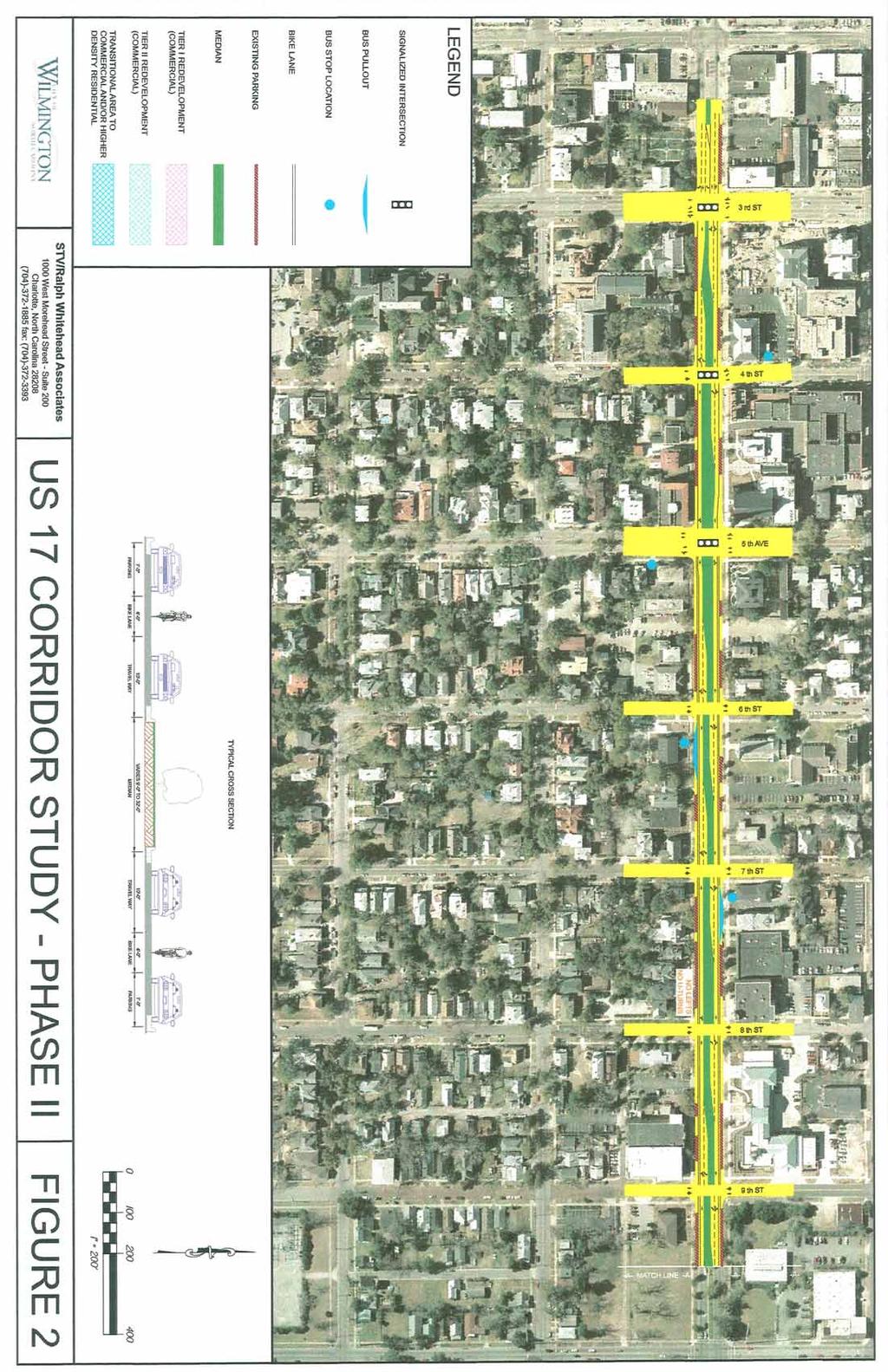
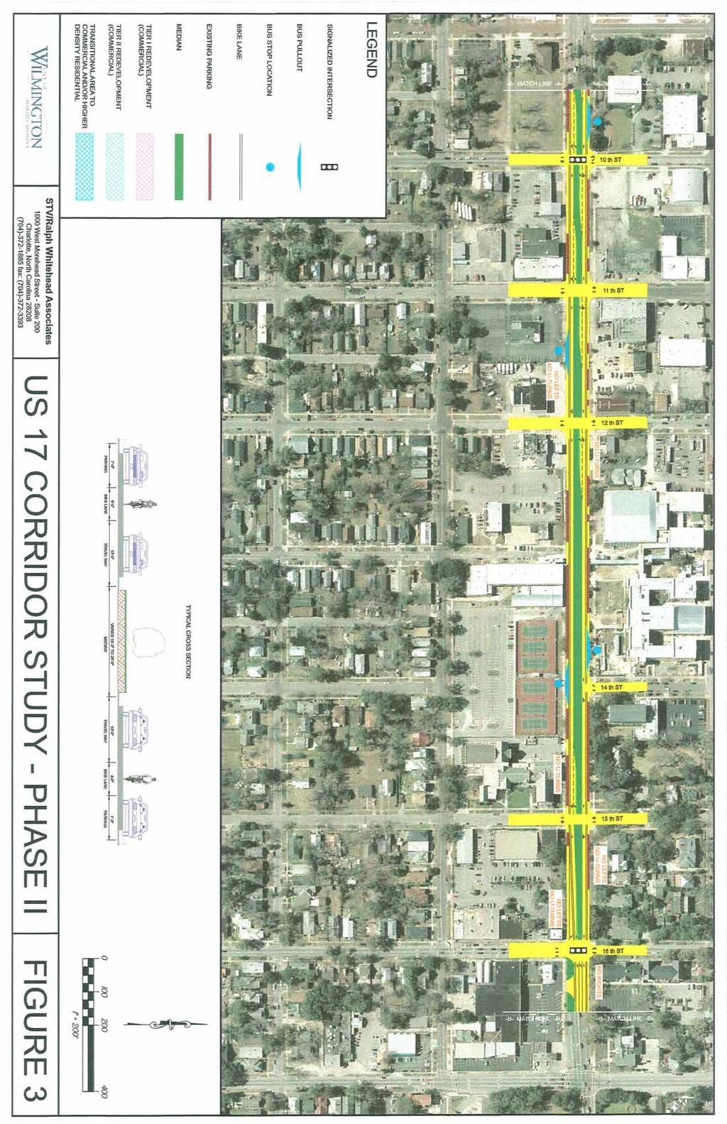
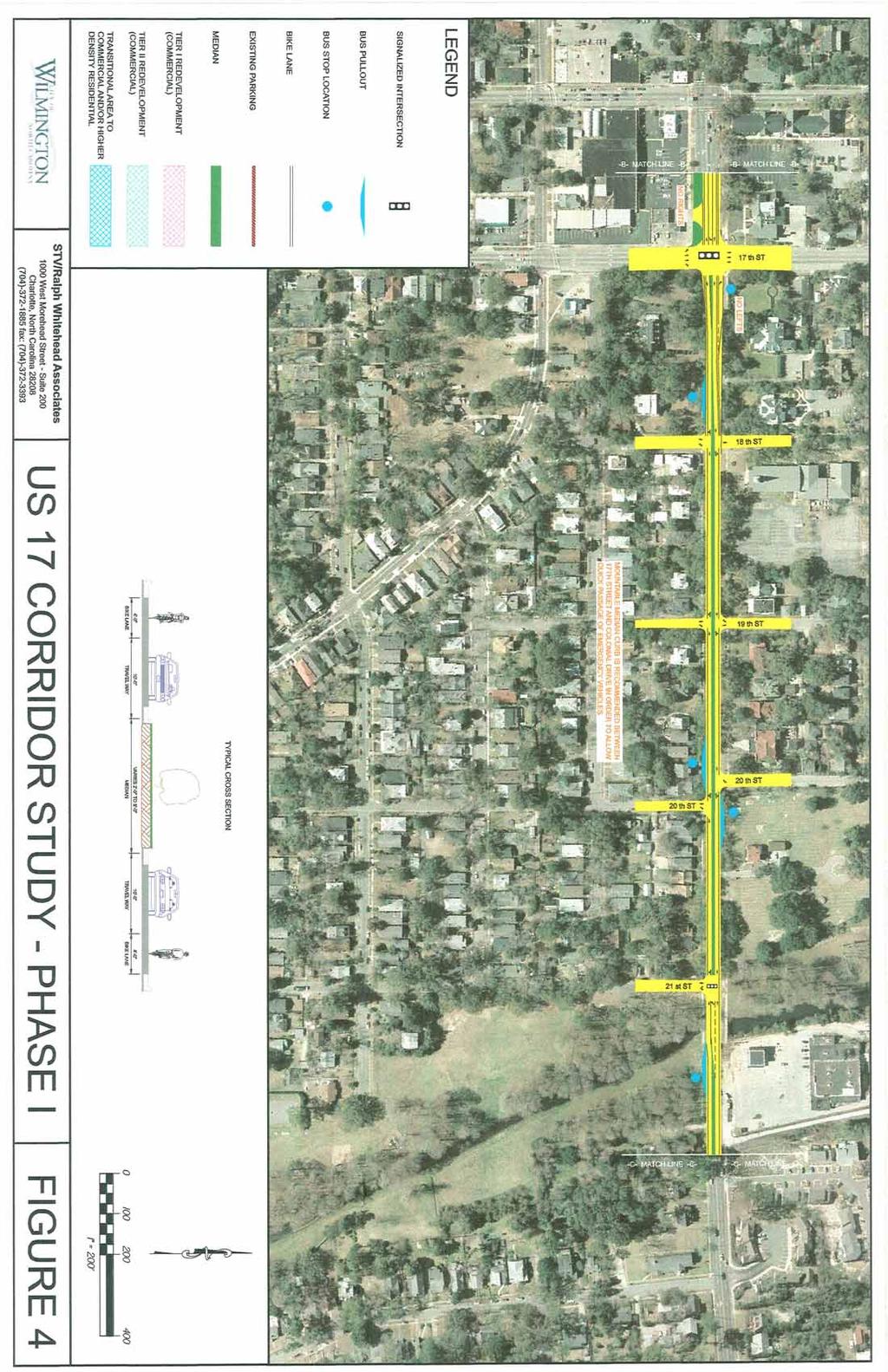
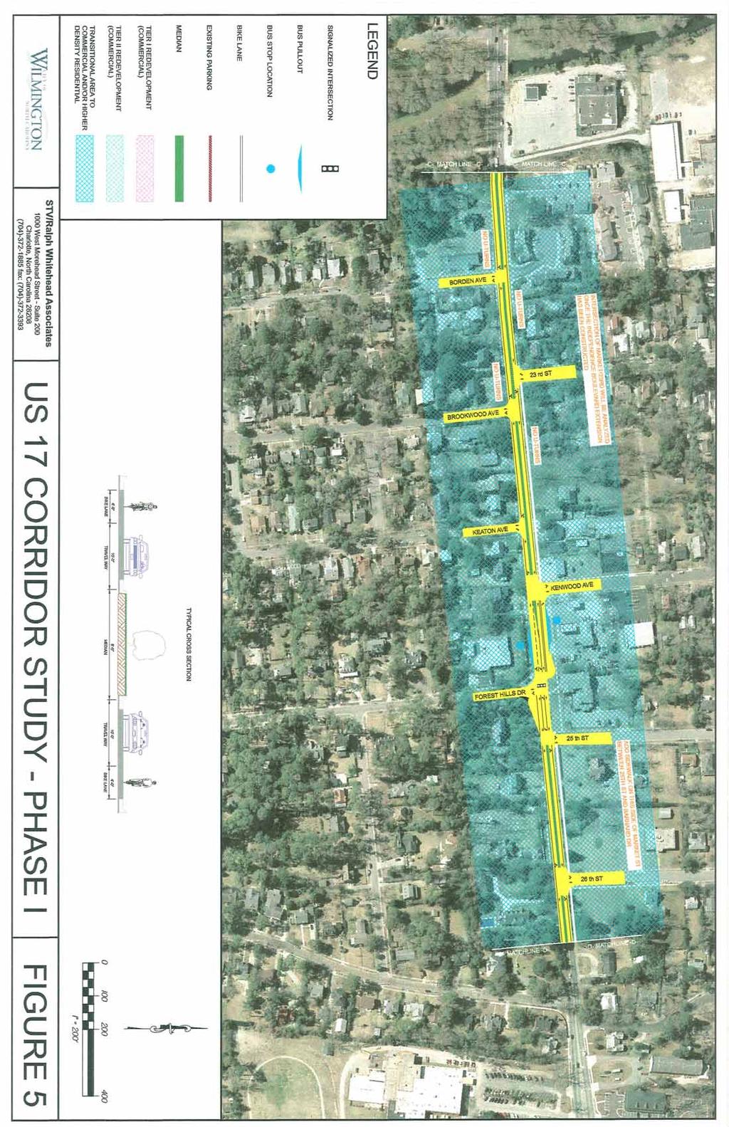
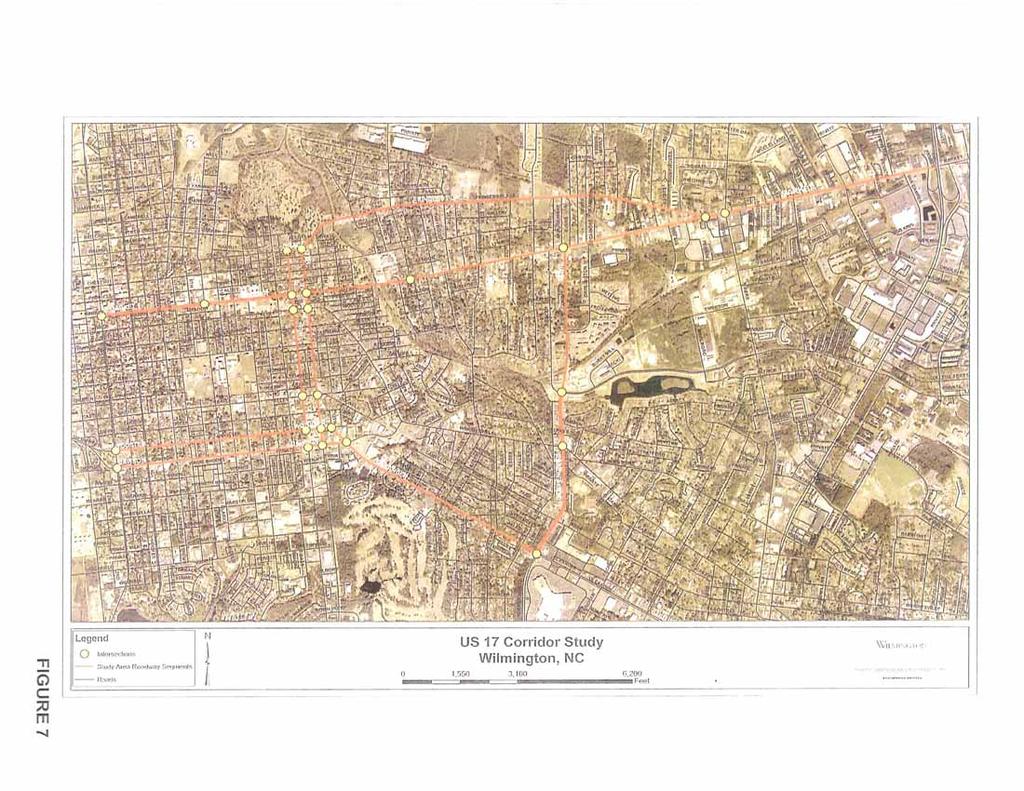
5 Existing Conditions Study Area The study area consists of US 17 Business (Market Street) from 3rd Street to Covil Avenue and 16 th and 17 th Streets to Dawson and Wooster Streets (see Appendix A, Figure 1). Older residential homes dominate Market Street with a mixture of business and cultural resource uses. Market Street, along this section of the corridor, retains its historical charm and aesthetically pleasing views. Older residential homes are found on 16 th and 17 th Streets with commercial properties taking over closer to the hospital. Roadway Geometry The typical section varies along Market Street. A 4-lane divided median section with limited on street parking is used between 3 rd Street and 16th Street. Starting at 17 th Street, the typical section drops to a narrow 36-foot section that has four 9-foot lanes with no median or center turn lane (see photo, right). The typical section widens back out at Colonial Drive to match the 5-lane undivided section that is carried out to Porter s Neck Road. Market Street s horizontal alignment is mostly straight throughout the entire study area. The vertical alignment is essentially flat with small variations in grade until it approaches the downtown area and the Cape Fear River. Traffic The existing traffic network was modeled using the regional travel demand model from the North Carolina Department of Transportation s Transportation Planning Branch (NCDOT/TPB). The study area for the traffic demand modeling is larger than the study area for improvements (see Appendix B, Figure 7) and consisted of the following routes. Market Street from 3 rd Street to College Road Covil Avenue/Independence Blvd. from Market Street to Oleander Drive Oleander Drive from Independence Blvd. to 17 th Street 16 th and 17 th Streets from Market Street to Dawson Street. Dawson and Wooster Streets from 3 rd Street to 17 th Street. Princess Place Drive from Market Street to 16 th Street. Page 2

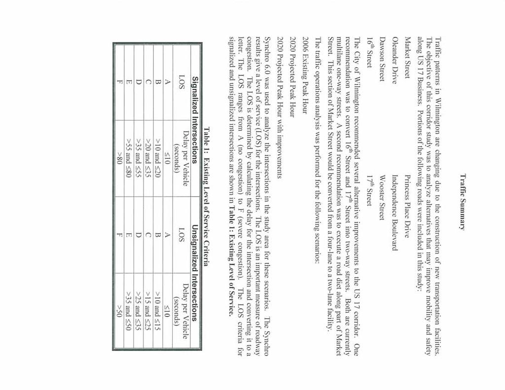
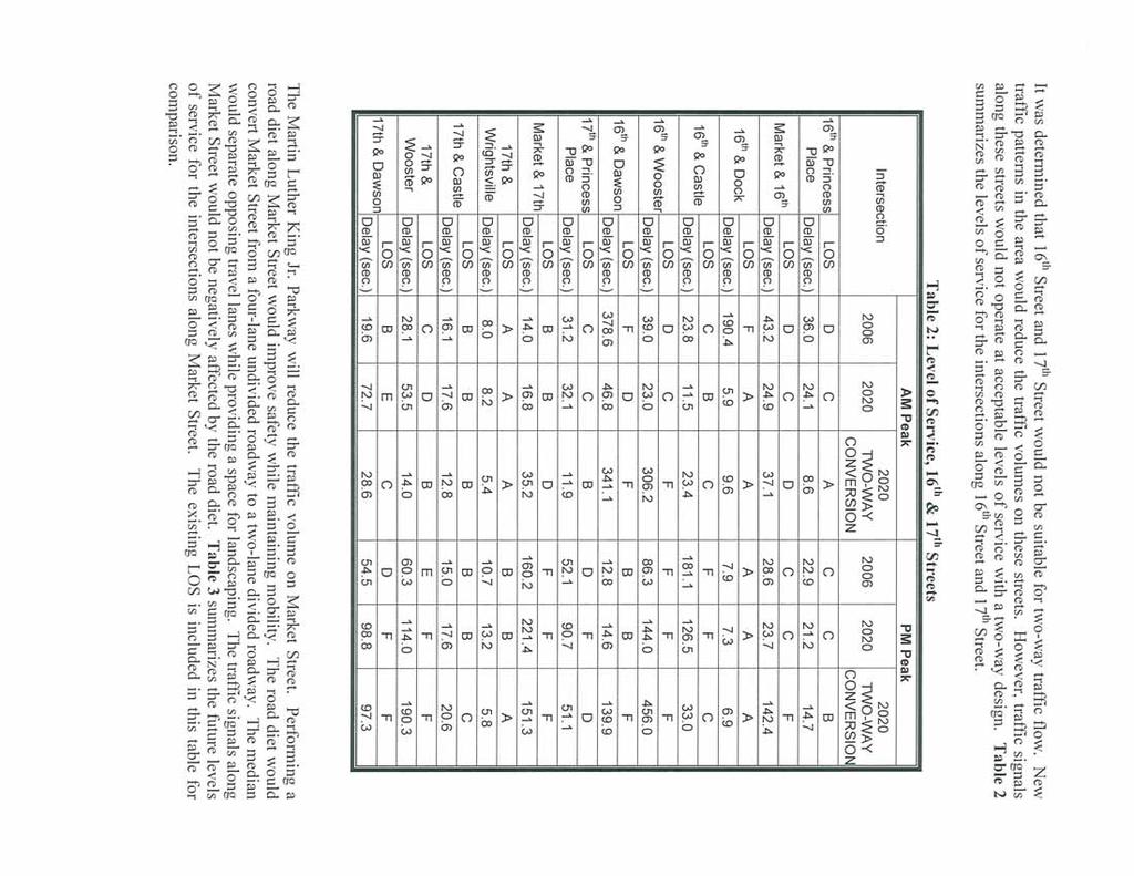
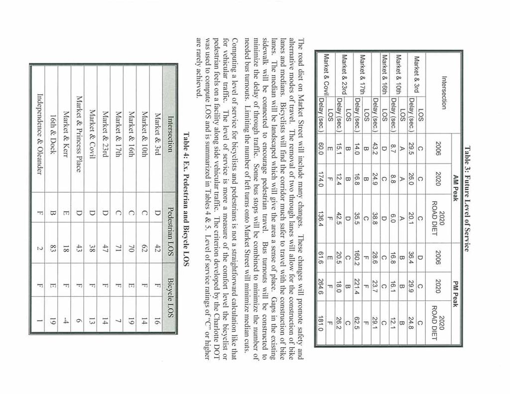
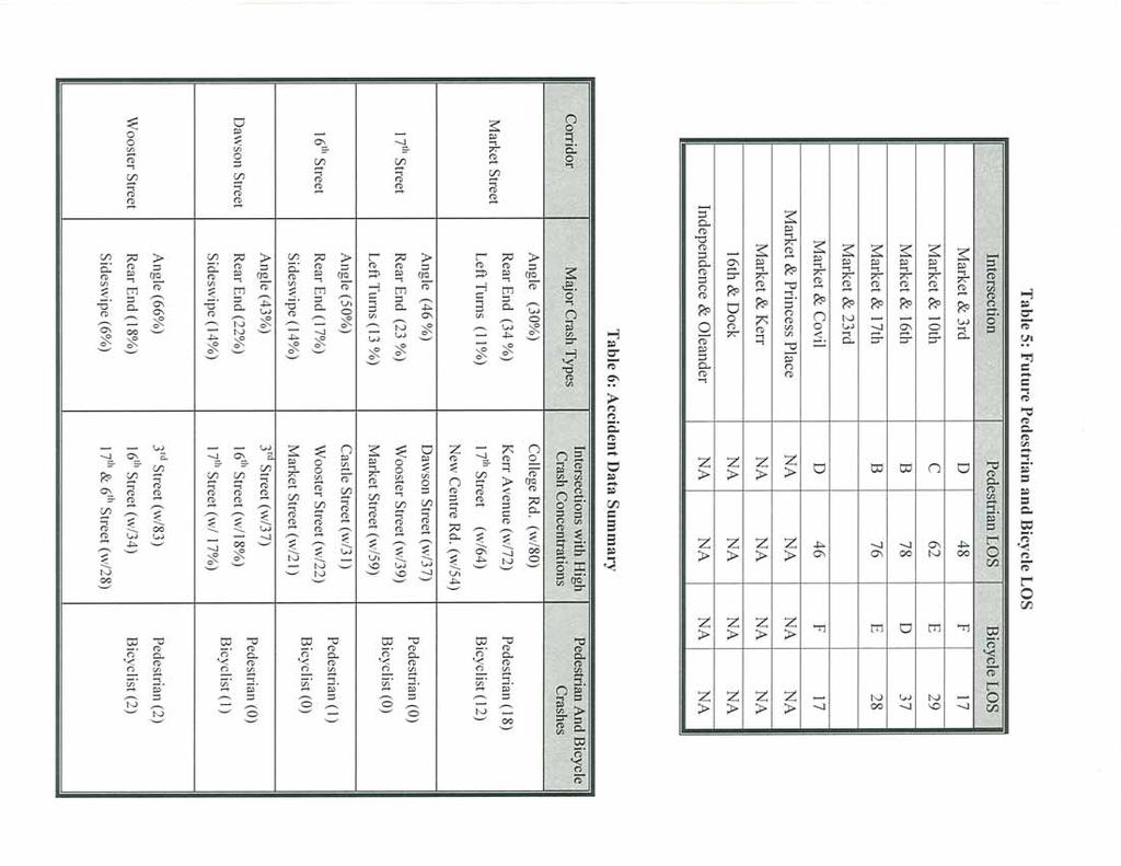
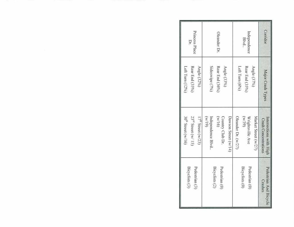
6 The city provided information on transit routes, bus stops, and bicycle and pedestrian facilities. Additional traffic counts were collected at critical intersections. The regional demand model provided projected traffic volumes for modeling alternatives in Synchro 6.0. Market Street is an east-west connector and is classified as a principal arterial in the North Carolina Statewide Functional Classification System (NCSFCS) from Covil Avenue to 16 th Street. From 16 th Street to 3 rd Street, it is classified as a minor arterial. Market Street currently carries from 13,600 46,300 vehicles per day (VPD) with traffic volumes lighter close to downtown and increasing toward Covil Avenue. However, the volumes are actually projected to decrease to 10,000 36,400 VPD by the year Level of Service (LOS), a measure of traffic congestion, was analyzed using Synchro 6.0. In urban areas intersection LOS tends to control the overall LOS of a corridor. Market Street falls into this category. During the evening (PM) rush hour the LOS ranges from C to F (see Appendix B, Table 1). Between Market Street and Dawson Street and Wooster Street, 16 th and 17 th Streets are classified as principal arterials. The current traffic volumes on 16 th and 17 th Streets are approximately 15,130 VPD and 15,240 VPD respectively. By 2020, they are expected to carry 13,150 VPD and 17,530 VPD respectively. These two streets currently operate as one-way pairs but were analyzed for the possibility of returning them to two-way traffic. At the intersections of Dawson and Wooster Streets, a LOS of F was computed for the future condition, which is unacceptable (see Appendix B, Table 2.) Accident Data Accident data for Market Street was analyzed for a three-year period from January 2003 to December Based on the information, there were approximately 1500 accidents along Market Street between 3 rd Street and College Road. The total crash rate, which is a measure of the number of accidents per vehicle miles traveled, is per 100 Million Vehicle Miles Traveled (MVMT) which is higher than the state average of MVMT for roads of similar function, location, and configuration. The majority of the accidents were either rear-end or angled collisions, which is indicative of a road that is over capacity. Within the defined study area, the higher concentrations of accidents in are from 17 th Street to around Colonial Drive. This is the section of Market Street with the 4-lane, undivided typical section. Additionally, there were 18 pedestrian accidents and 12 bicycle accidents. A summary of the Accident Data can be found in Appendix B, Table 6. Transit The Cape Fear Public Transportation Authority operates WAVE Transit. In the study area, WAVE has 16 existing bus stops. Two routes cover Market Street; Route # 2 (Marketplace Mall/UNCW) and Route # 4 (Eastwood Rd. /Mayfaire). Additionally, routes 5 & 6 also use Market Street between 2 nd Street and 5 th Avenue. Monday through Friday the routes run a bus every half hour from 6:30am to 8:30pm. However, in the transit authority is planning to completely restructure its routes. Continued coordination will need to take place as the project Page 3

7 goes to the preliminary and final design stages. downtown. The WAVE also operates two historic trolleys Parks Wallace Park is situated between Market Street and Metts Avenue and is accessed from 21 st Street. Burnt Mill Creek flows through the middle of the park. The facility is lighted and offers playgrounds, picnic areas, and athletic fields. Cultural Resources Wilmington offers numerous cultural resources and historic sites from the USS North Carolina Battleship to the Historic Downtown District. The following cultural resources are found in the study corridor. The Bellamy Mansion is under the stewardship of Preservation North Carolina and is an excellent example of antebellum architecture. It is located at the corner of Market Street and 5 th Avenue and operates as a museum and gallery for design arts. Another museum located along Market Street is the Cape Fear Museum of History and Science. Located at the corner of 8 th Street and Market, it is the oldest continuously operating museum of history in North Carolina. Wilmington National Cemetery is located adjacent to Burnt Mill Creek between Borden Avenue and 20 th Street. It is listed on the National Register of Historic Places and was opened after the Civil War. The Burgwin-Wright House, an example of Georgian architecture, is located on Market Street between 2 nd Street and 3 rd Streets. The house is also listed on the National Register of Historic Places and serves as the headquarters for the Colonial Dames of North Carolina. The Market Street Mansion District runs from 17 th Street to approximately 20 th Street and is listed on the National Register of Historic Places. These homes were built between 1900 and 1924 and follow the Classical or Colonial Revival architecture style. Bicycle and Pedestrian Facilities The majority of Market Street is not currently designated as a bicycle route and does not provide a designated lane. Market Street between 23 rd Street and Forest Hills has recently been added as part of Wilmington s local bike route system. Sidewalks line both sides of Market Street except on the north side between 23 rd Street and Kenwood Avenue and between 25 th Street and Barnard Drive. Sidewalk is continued from Barnard Drive out to College Road. The sidewalk in several locations is in need of repair. A Level of Service for both cyclists and pedestrians was analyzed. The LOS for bicycles and pedestrians is more complex than for vehicular traffic and is a measure of the comfort level they Page 4
8 experience in relation to vehicular traffic. The existing level of service for bicycles is F and the existing level of service for pedestrians ranges from C to F (see Appendix B, Table 4). Zoning and Land Use Zoning in the study area is a combination of Commercial, Office & Institutional, and Single-Family homes. From 3 rd Street to approximately 17 th Street, the zoning is dominated by Office & Institutional on the north side and residential on the south side. Land use in this area includes law offices, churches, schools, cultural resources and private single family homes. The land use from 17 th Street to Covil Avenue is almost exclusively residential with a few commercial uses interspersed. The land use along 16 th and 17 th is predominately single family homes until Castle Street where it changes over to small commercial businesses and some vacant lots. Adopted Corridor and Land Use Plans The City of Wilmington has taken a very proactive approach toward future planning. The Market Street Corridor Plan was adopted in 2004 and was the first attempt to qualify the vision citizens had for this area. The overwhelming request was for a return to aesthetics, less congestion, preservation of the residential areas, and future requirements for redevelopment in the area from Covil Avenue toward College Road to move away from strip development and poor access management practices. Choices The Wilmington Future Land Use Plan lays the foundation for guiding the development of the remaining vacant tracks of land within the city s limits. The plan sets guiding principals and then objectives to achieve the desired results. Along Market Street there are areas designated as Tier 1 and Tier 2 Redevelopment Areas, with Tier 1 areas having higher priority (see Appendix A, Figures 5 & 6). The Wilmington Metropolitan Planning Organization prepared the Wilmington Urban Area 2030 Long Range Transportation Plan that addresses all modes of transportation needs and solutions coupled with the required financial needs. In particular, the plan stated that the main barriers to bicyclists are a lack of direct, continuous, convenient, and safe system of bicycle facilities. The plan also recognizes the need to improve pedestrian facilities to encourage walking as an alternate mode of transportation. Corridor studies have also been adopted for College Road and Oleander Drive, which are part of the major transportation system within Wilmington. Vision 2020 was adopted in 1997 to balance economic development with historic and natural environment preservation of Wilmington s waterfront district. Other Transportation Improvement Initiatives Several transportation improvement initiatives are underway or planned for the future that affect the study corridor. The North Carolina Department of Transportation (NCDOT) is studying access management options along Market Street starting at Colonial Drive and ending at SR 1402 (Porter s Neck Road). Independence Blvd. Extension (U-4434), which is a new multi-lane roadway that will run from Randall Parkway to MLK Parkway, is in the planning and design phase with the construction phase having no funding. Military Cutoff Road Extension (U-4751) is in the planning and design phase, with right of way acquisition scheduled for Fiscal Year 2012 and construction currently unfunded. Page 5
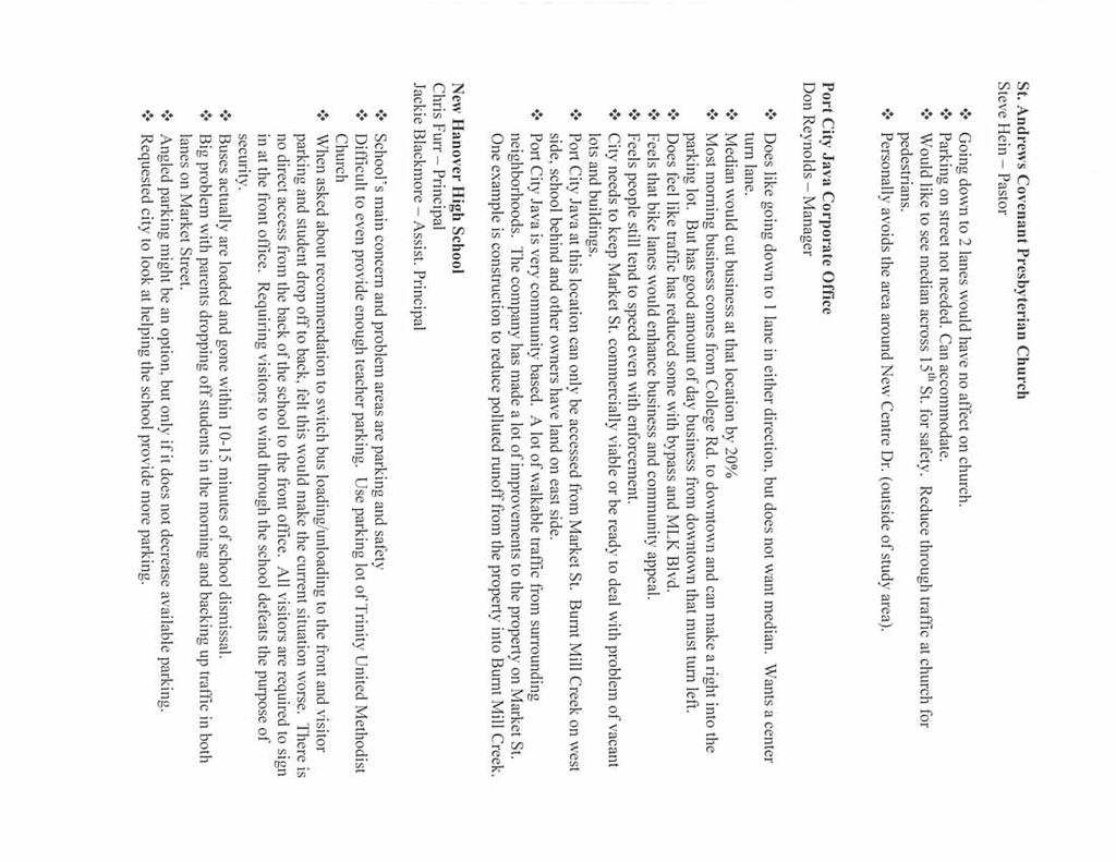
9 The North Carolina General Assembly is reviewing a bill (House Bill 2682) to allow New Hanover County to hold a bond referendum to raise funds through sales and use taxes to pay for transportation and other infrastructure improvements. Both U-4434 and U-4751 are two of the projects slated to be accelerated with the additional funds. Public Involvement Public involvement was a key element in studying the US 17 corridor. A Steering Committee, composed of representatives from the City of Wilmington, NCDOT, the Chamber of Commerce, and WMPO, was put in place to assist in guiding the project. A total of four committee meetings were held. Minutes from the each meeting can be found in Appendix C. The committee was composed of the following people. Name Organization Name Organization Mike Kozlosky Wilmington MPO Monica Kerr NCDOT/TPB Joshuah Mello Wilmington MPO Joe Blair NCDOT Christine Laughlin City of Wilmington Jackson Provost NCDOT Don Bennett City of Wilmington Anthony Law NCDOT Brian Chambers City of Wilmington Patrick Riddle NCDOT Tom Cunningham Chamber of Commerce Brock LaForty STV/RWA Two public workshops were held, one on August 3, 2006 and another on January 9, These were conducted in an informal setting at the New Hanover High School located on Market Street. People were given the opportunity to view the proposed changes to Market Street and offer their comments and suggestions. Citizens were given a 30-day period after each workshop to submit their comments. A summary of comments from each workshop can be found in Appendix C. Additionally, individual stakeholder interviews were conducted based on recommendations from the City of Wilmington Planning Department. These were a combination of businesses and churches located on Market Street as well as the director of the Bellamy Mansion, the chief for the Wilmington Fire Department, and the principal for New Hanover High School. A summary of comments from each workshop can also be found in Appendix C. The major comments were: Do not place the median between 16 th Street and 17 th Street. The block is too short and many patrons to the businesses within this block are able to make a left turn in during the left turn cycle of the light at 16 th. The worse section of Market Street is from 17 th Street to Covil Avenue. Consider phasing the project to improve conditions in this area first, and then re-evaluate the corridor. Fix the drainage problem at 14 th Street and Market. This area is prone to flooding. The high school and Trinity Methodist Church have suffered repeated flood damage. Discourage tractor-trailers from using Market Street. Page 6
10 Provide EMS responders the ability to maintain current required standard of response times. Remove on street parking for Market Street. Seen as a safety hazard. Take into consideration the affect a median would have on existing businesses. Retain the existing trees and continue the decorative lighting. Reduce crime by stepping up patrols. Be consistent with the typical section used. Do not mix 2-lane and 4-lane sections. City of Wilmington Traffic Engineering expressed concerns on using the Road Diet concept from 3 rd Street to 16 th Street. This area has on street parking and numerous bus stops and there is the potential for traffic to be slowed or halted by parallel parking maneuvers and stopped buses. These comments were reflective of the individual comments received from citizens that attended the two workshops. Alternatives The project had several constraints that all alternatives had to meet. All alternatives must stay within the existing right of way to minimize costs and environmental impacts. Emergency Management Services (EMS) must not be hampered. The existing trees along Market Street must be preserved. Alternatives must look at combinations of access management and Road Diet concepts. For additional information on Road Diets, please reference Appendix D. Alternatives Studied The study looked at a combination of alternatives and their potential impact on the rest of the transportation network in and around the study area. The study alternatives are described below. Alternative 1 - Do nothing. Alternative 2 - Reduce Market Street from four lanes of traffic down to one lane in either direction with a landscaped median, bike lanes, and limited on-street parking. Reduce the number of intersections with full access down to the major intersections. Return 16 th and 17 th Streets back to two-way traffic. Alternative 3 - Reduce Market Street from four lanes of traffic down to one lane in either direction with a landscaped median, bike lanes, and limited on-street parking. Reduce the number of intersections with full access down to the major intersections. Maintain 16 th and 17 th Street as one-way pairs. Additionally, traffic flow around New Hanover High School was evaluated for efficiency. Alternatives Eliminated Alternative 1 would maintain Market Street in its current condition. However, this alternative would not discourage undesirable commercial development along Market Street in the transitional areas. Additionally, this alternative does not address the request for improvements in traffic congestion and safety and improved aesthetics. Page 7

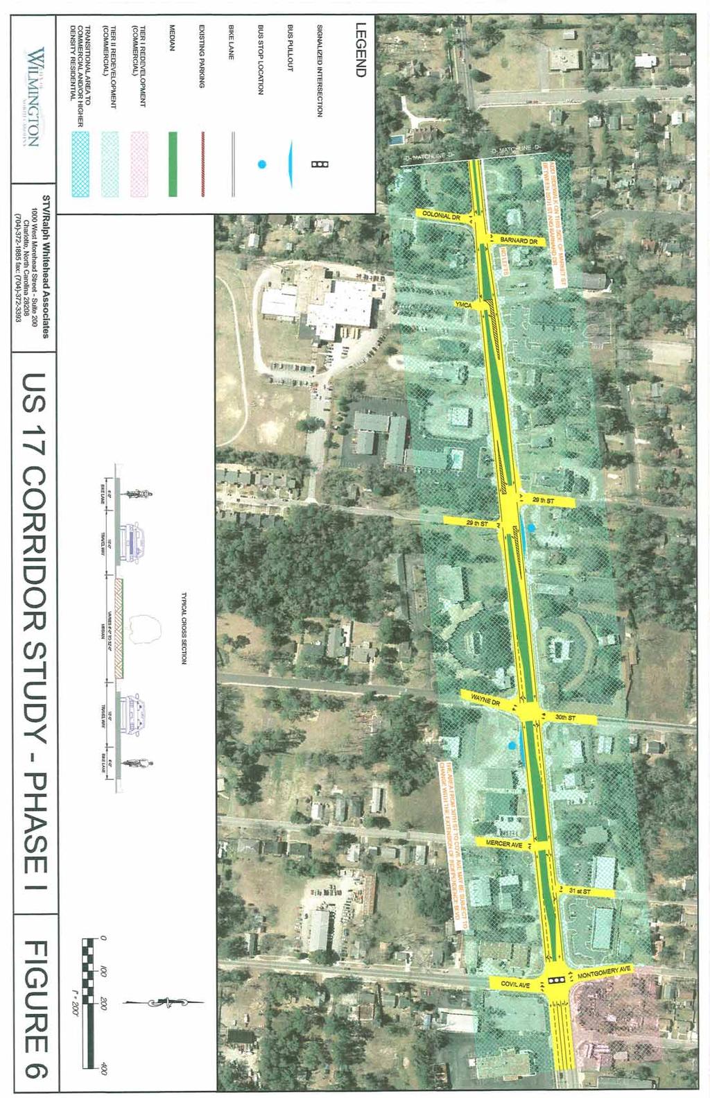
11 Alternative 2 was eliminated because traffic modeling indicated that returning 16 th and 17 th Streets back to two-way traffic would not be possible without creating problems at the intersections with Dawson Street and Wooster Street. Although traffic volumes would be reduced in the future conditions, the signalized intersections along these streets would not operate at an acceptable level of service (see Appendix B, Table 2). New Hanover High School s visitor parking and student drop-off area is on Market Street. Numerous comments were made about this area and the safety hazard it poses. The bus drop-off area is in the back of the school. A recommendation was made to move the bus drop-off to the front of the school and the visitor/drop-off area to the back of the school. However, in the stakeholder interview with the school, they requested this alternative be dropped. Visitors are required to check in at the office and parking in the back of the school would encourage them to cut through the school building, which is unacceptable. Observations of the bus loading in the afternoons made it clear that the school s current system works very efficiently with only minor interruptions to traffic on Princess Place. The buses were loaded and away within 10 minutes of the dismissal bell. Therefore, this alternative was also eliminated from further study. Preferred Alternative Alternative 3 is the recommended alternative (see Appendix A, Figures 2-6). The proposed alternative applies the Road Diet concept and reduces the typical section from 4-lanes down to 2-lanes, with a raised, landscaped median, left turn lanes where appropriate, bike lanes and some on street parking. Median openings are provided as needed based on traffic modeling with Synchro and input from the Steering Committee and local citizens. In the narrow section between 17 th Street and Colonial Drive, the median will have mountable curbs to allow traffic to move over for EMS vehicles. The project will be constructed in two phases. Phase I will run from 17 th Street to Covil Ave. Phase II will encompass the remainder of the project from 3 rd Street to 17 th Street. Designated bike lanes are provided on both sides of Market Street from 5 th Avenue Street to Kenwood Avenue. It should be noted that the existing bridge over Burnt Mill Creek is not equipped with adequate bicycle rails. From Kenwood Avenue to Forest Hills, a bike lane will be provided on the north side of Market Street to accommodate the existing bicycle route at this location. Bike lanes will be provided on both sides of Market Street again beginning at 25 th Street to the end of the project at Covil Avenue. Bike lanes are not designated from 3 rd Street to 5 th Avenue because of limited space for left turn lane storage. However, the outside lanes in this area can be wider than 10 feet to accommodate cyclists. Bicycle lanes were not revised to be on the outside of the paved roadway width as requested by the American Institute of Architects (see letter Appendix C). On street parking along Market Street is intermittent. Placing parking spaces between the travel lane and the bike lane would be confusing to motorists who would potentially see it as an additional lane. The bike lanes in this conceptual plan follow standard design practice. Sidewalks are added where needed to provide continuity. The future LOS for cyclists and pedestrians is estimated to range from C to F (see Appendix B, Table 5). A LOS of C or better is rarely obtained, based on current standards. Page 8
12 The Level of Service (LOS) for vehicular traffic was computed for the preferred alternative and compared to the future LOS for the no build scenario. Based on this analysis, the LOS for the preferred alternative is basically the same as the LOS for the no build scenario (see Appendix B, Table 3). Therefore, using a Road Diet along Market Street will maintain the expected future LOS while improving safety for all modes of transportation and meeting the desire for aesthetics. The proposed alternative stays within the existing right of way and preserves the existing trees lining the street as well as the ones planted in the median from 3 rd Street to 15 th Street. The existing bus stops were consolidated and bus turnouts provided to allow buses to get out of the travel lane while stopped. At several intersections, bulb outs were used to accommodate traffic making u-turns. Estimate Preliminary costs for the project were computed and are summarized in Table 1. Each phase of the project is shown in order to facilitate future decision making concerning funding. Quantities for the construction costs are based on the initial conceptual plans and typical section. The costs are based on NCDOT bid pricing. These are initial estimates and will need to be refined as future decisions are made. Concrete Sidewalk will only be required in Phase I. Table 1 Description Phase I Phase II Drainage $ 55,000 $ 30,000 Earthwork $ 35,000 $ 25,000 Pavement Resurfacing $ 320,000 $ 345,000 New Pavement & Concrete Sidewalk $ 111,800 $ 39,200 Pavement Removal $ 64,800 $ 44,000 2'-6" Curb & Gutter $ 64,600 $ 19,000 1'-6" Curb & Gutter $ 384,000 $ 336,000 Traffic Signal Removal/Installation $ 62,510 $ 10,520 Erosion Control $ 40,000 $ 26,000 Traffic Control, Thermo and Markers $ 74,000 $ 78,000 Landscaping $ 15,000 $ 15,000 Mobilization Rdy (5%) $ 61,336 $ 48,386 Contingency (40%) $ $ 87,088 Note: All costs are based on NCDOT bid pricing. Contract Cost $ 1,778,730 $ 1,403,194 Engineering (15%) $ 267,000 $ 211,000 Total Construction Cost $ 2,045,730 $ 1,614,194 Page 9

.")
13 Access Management Initiatives Access management refers to controlling ingress and egress along a corridor in order to maintain or enhance the corridors capacity and safety. Access management initiatives include providing full left and right turn movements only at major intersections, requiring developers to provide access between adjacent residential neighborhoods or connectivity between parking lots for commercial properties, and limiting the number of driveways within a corridor (see picture, right). Based on several studies, five lane sections with center turn lanes increase the number accidents in a corridor by increasing the number of conflict points (see picture, next page). Synchro was used to model what if scenarios based on providing full access at some locations and right in-right out access at others. Recommendations from the Citizens Informational Workshop on this issue were taken into account during the modeling. Because the area is predominately residential or homes converted to commercial use, requiring access from one property to another is not practical. Reducing the number of driveways in the corridor is also not feasible; again because of the predominately residential uses. The existing grid system in the study corridor does provide good connectivity; therefore, eliminating full access at some locations is feasible. Page 10
14 Page 11
15 Policy Recommendations Access Management Future decisions concerning land use along Market Street should continue to following the adopted land use plans and the vision the residents want for this area. These land use decisions should take into account best practices for access management such as driveway density and required connectivity between commercial properties. Design Elements Typical Section The basic typical section should include a raised landscaped median with bike lanes. It should maintain one travel lane in each direction and provide for left turn storage where needed as well as on street parking. Medians The medians should be designed as raised medians with standard curb and gutter. In areas where space is limited, a mountable curb should be used with brick pavers to allow room for cars to move out of the travel lane for EMS equipment. Page 12


16 Crosswalks Crosswalk treatments should make a distinction between the travel lane and the pedestrians space. When crosswalks stand out they encourage pedestrians to use them rather than cross where they please. Several options can be used for designing crosswalks. They are as simple as standard pavement markings with white paint to more aesthetically pleasing ones that use brick pavers or other construction materials for the crosswalk area. It is recommended that the city use materals, such as stamped asphalt or brick pavers, to highlight the crosswalks to increase visibility and safety. Page 13


17 Bus Stop Areas Bus stop pullouts are essential to maintaining the flow of traffic with the reduction of lanes. These pullouts allow for buses to get completely out of the travel lane to pick up passengers and not back up traffic. The designs for the pullouts need to follow the AASHTO guidelines which call for a width of 10 feet, 50-foot tapers, and 50 feet of storage. These pullouts should be accommodated within the existing Right-of-Way. Current and future bus stop placement should be analyzed to make sure citizens are adequately served without having a bus stop at every corner. Bus stops should be ADA accessible and provide shelters. Shelters and other features should not be placed in the main sidewalk area. The final shelter structure should blend in with the surrounding character of the area. Page 14

.")

18 Bike Lanes Bike lanes should be a minimum of 4.0 feet in width and clearly delineated with distinctive markings as shown in the photographs below from Pedestrian and Bicycle Information Center s website ( Signs should be posted to direct bicyclist and keep them on preferred routes. Bike racks should also be located at logical termini for cyclists to use and it is highly recommended that the WAVE Transit Authority provide for bike racks on the buses using this route. Page 15
19 Bulb Outs Bulb outs are placed at T-intersections to accommodate u-turn movements. The design for the bulb outs should be based on the minimum turning path radius of a passenger car as found in the AASHTO guidelines. Implementation Plan Project Phasing The City of Wilmington and NCDOT will need to complete the Independence Blvd. extension from Market Street to MLK Parkway before work can begin on the proposed improvements to this section of Market Street. Once the project enters into the preliminary and final design stages, it will be divided into two phases. Phase I will be from Covil Avenue to 17 th Street. Improvements in this area are needed in order to remove left turning traffic out of the through lane and to provide a divided median to enhance safety. Once this phase is complete, the traffic patterns will be analyzed again to determine if Phase II, from 17 th Street to 3 rd Street is feasible to implement. Project Funding As discussed under other transportation initiatives, the North Carolina General Assembly is working on House Bill 2682, which would allow New Hanover County to hold a bond referendum proposing to raise sales and use taxes in order to fund needed infrastructure improvements. Other potential funding options that could be explored are public-private partnerships (PPP) and Garvey Bonds. Any PPP should be looked at with the vested interest toward the goals set by the citizens of Wilmington and the common good. The Safe, Accountable, Flexible, Efficient Transportation Equity Act: A Legacy for Users (SAFETEA-LU) enacted by Congress requires a state to set aside funding for enhancement projects. In North Carolina, these enhancement funds can be used to modify or add bicycle and pedestrian facilities to existing roadways. Since the proposed improvements to Market Street include enhancements for bicyclists, the project may be eligible for some funding through this program. Conclusion US 17 Business (Market Street) served as a major route to several North Carolina beaches and provided the main Cape Fear River crossing. Additionally, it was the main thoroughfare into the historic downtown area. Recent transportation improvements offer alternate routes to popular destinations that reduce the need to use Market Street. A reduction in traffic has been seen and is expected to continue into the future as additional transportation initiatives are funded. This reduction in traffic allows the City of Wilmington and the Wilmington MPO to take a fresh look at Market Street in terms of function and aesthetics. A Road Diet conceptual plan was analyzed and found to function at an acceptable level of service while providing improved safety along the corridor and enhancing multimodal facilities. The citizens in the study area are in favor of the changes proposed in the conceptual plan. Therefore, it is recommended that the City of Wilmington use Alternate 3 for moving forward with improvements to Market Street. Page 16
20 APPENDIX A Figures
21
22
23
24
25
26
27 APPENDIX B Traffic Summary
28
29
30
31
32
33
34
35
36
37
38
39
40
41
42
43
44
45
46
47
48

49
50
51
Corpus Christi Metropolitan Transportation Plan Fiscal Year Introduction:
 Introduction: The Safe, Accountable, Flexible, Efficient Transportation Equity Act: A Legacy for Users (SAFETEA-LU) has continued the efforts started through the Intermodal Surface Transportation Efficiency
Active Transportation Facility Glossary
 Active Transportation Facility Glossary This document defines different active transportation facilities and suggests appropriate corridor types. Click on a facility type to jump to its definition. Bike
Chapter 5 Future Transportation
 Chapter 5 Future Transportation The Future Land Use Plan identifies the desired land use designations. The land uses desired for Crozet depend, in large part, on the success of the transportation system,
Recommended Roadway Plan Section 2 - Land Development and Roadway Access
 Recommended Roadway Plan Section 2 - Land Development and Roadway Access SECTION 2 Land Development and Roadway Access 2.1 Land Use and Access Management The Federal Highway Administration (FHWA) defines
Tonight is for you. Learn everything you can. Share all your ideas.
 Strathcona Neighbourhood Renewal Draft Concept Design Tonight is for you. Learn everything you can. Share all your ideas. What is Neighbourhood Renewal? Creating a design with you for your neighbourhood.
Omaha s Complete Streets Policy
 Omaha s Complete Streets Policy (Adopted August 2015) VISION To create great places and enhance our quality of life, the City of Omaha will provide safe, accessible streets for all users. Complete Streets
APPENDIX A: Complete Streets Checklist DRAFT NOVEMBER 2016
 APPENDIX A: Complete Streets Checklist DRAFT NOVEMBER 2016 Complete Streets Checklist MetroPlan Orlando s Complete Streets Checklist is an internal planning tool for staff to further implementation of
Broad Street Bicycle Boulevard Design Guidelines
 Broad Street Bicycle Boulevard Design Guidelines Building from the strategies introduced in the 2013 Bicycle Transportation Plan and community input received thus far, City Transportation Staff have identified
Lee s Summit Road Improvement Study Public Open House June 7, 2007 Summary of Comment Card Responses
 Lee s Summit Road Improvement Study Public Open House June 7, 2007 Summary of Comment Card Responses Introduction At the Lee s Summit Road Improvement Study Public Open House held Thursday, June 7, 2007
COWETA HIGH SCHOOL AND EAST HIGHWAY 51
 COWETA HIGH SCHOOL AND EAST HIGHWAY 51 Lack of sidewalks along Ben Lumpkin Rd. Lack of crosswalks and ramps at intersection. Hwy 51 is wide to cross as a pedestrian. No ADA compliance or connection to
Road Diets FDOT Process
 Florida Department of TRANSPORTATION Road Diets FDOT Process Humberto Castillero, PE, PTOE Roadway Design Office Purpose of Guide Develop a statewide lane elimination review process Balance state & local
M-58 HIGHWAY ACCESS MANAGEMENT STUDY Mullen Road to Bel-Ray Boulevard. Prepared for CITY OF BELTON. May 2016
 M-58 HIGHWAY ACCESS MANAGEMENT STUDY Prepared for CITY OF BELTON By May 2016 Introduction Missouri State Highway 58 (M-58 Highway) is a major commercial corridor in the City of Belton. As development has
MAG Town of Cave Creek Bike Study Task 6 Executive Summary and Regional Significance Report
 Page 1 MAG Town of Cave Creek Bike Study Task 6 Executive Summary and Regional Significance Report August 1, 2012 MAG Project #481 Page 2 Task 6 Executive Summary and Regional Significance Report Introduction
Chapter 2: Standards for Access, Non-Motorized, and Transit
 Standards for Access, Non-Motorized, and Transit Chapter 2: Standards for Access, Non-Motorized, and Transit The Washtenaw County Access Management Plan was developed based on the analysis of existing
Appendix C. TRAFFIC CALMING PROGRAM TOOLBOX
 Appendix C. TRAFFIC CALMING PROGRAM TOOLBOX PHASE I...2 Do Not Enter Sign...3 One-Way Sign...4 Turn Prohibition...5 Pavement Markings...6 Speed Monitoring Trailer...7 Neighborhood Speed Watch...8 Police
Report. Typical Sections. City of Middleton, WI
 Report Typical Sections City of Middleton, WI December 2006 Report for City of Middleton, Wisconsin Typical Sections repared by: Traffic Associates LLC and STRAND ASSOCIATES, INC. 910 West Wingra Drive
Item to be Addressed Checklist Consideration YES NO N/A Required Description Complete Streets Guidelines
 Passaic County Complete Streets Checklist - Concept Development Project Name Item to be Addressed Checklist Consideration YES NO N/A Required Description Complete Streets Guidelines Existing Plans Have
CONNECTIVITY PLAN. Adopted December 5, 2017 City of Virginia Beach
 CONNECTIVITY PLAN Adopted December 5, 2017 City of Virginia Beach CONTENTS 1.0 Background & Purpose... 2 2.0 Existing Inventory & Analysis... 3 ViBe District Existing Walking Conditions... 4 3.0 ViBe District
Goodlettsville Bicycle and Pedestrian Plan Executive Summary
 Goodlettsville Bicycle and Pedestrian Plan July 2010 In Cooperation with the Nashville Area Metropolitan Planning Executive Organization Summary Introduction Progressive and forward thinking communities
HARRISON STREET/OAKLAND AVENUE COMMUNITY TRANSPORTATION PLAN
 HARRISON STREET/OAKLAND AVENUE Community Workshop #4: Draft Plan Review December 3, 2009 D E S I G N, C O M M U N I T Y & E N V I R O N M E N T INTRODUCTIONS Key Project Staff: Alisa Shen, Project Manager,
NORTH HIGHLAND LAKE ROAD PROJECT
 NORTH HIGHLAND LAKE ROAD PROJECT The purpose of this special newsletter is to inform the residents of Flat Rock about the facts concerning the proposed N. Highland Lake Road Project and clarify some misconceptions.
County of Greenville South Carolina. Traffic Calming Program Neighborhood Traffic Education Program and Speed Hump Program
 County of Greenville South Carolina Traffic Calming Program Neighborhood Traffic Education Program and Speed Hump Program (rev) August 2008 I. PURPOSE The potential negative impacts from vehicular traffic
Multimodal Through Corridors and Placemaking Corridors
 68 Multimodal Through Corridors and Placemaking Corridors Corridors have different functions in a region. Some corridors are used to get smoothly and rapidly through a region or to get quickly to major
REGIONAL BICYCLE AND PEDESTRIAN DESIGN GUIDELINES
 REGIONAL BICYCLE AND PEDESTRIAN DESIGN GUIDELINES November 16, 2011 Deb Humphreys North Central Texas Council of Governments Bicycle and Pedestrian Advisory Committee Snapshot of the Guide 1. Introduction
STREET AND HIGHWAY PLAN
 STREET AND HIGHWAY PLAN Introduction The street and highway system in the Winston-Salem Urban Area consists of thousands of miles of traffic carrying facilities, ranging from short local residential streets
5. RUNNINGWAY GUIDELINES
 5. RUNNINGWAY GUIDELINES These guidelines should be considered collectively when making runningway decisions. A runningway is the linear component of the transit system that forms the right-of-way reserved
City of Gainesville Transportation/Roadway Needs PROJECT SUMMARY
 A1 Roadway Resurfacing $23,846,000 TYPE: Preservation of existing system Roadway resurfacing A2 Signal Replacement $6,000,000 TYPE: Preservation of existing system Replace traffic signals. B1 W 6th St
INDOT Complete Streets Guideline & Policy
 INDOT Complete Streets Guideline & Policy INTRODUCTION The Complete Streets guidelines build upon multiple efforts and promote a multimodal transportation system that is integrated and sustains land use
UDC Street Cross Sections
 UDC Street Cross Sections Local Street - Downtown Local Street Mountable Curb Local Street Vertical Curb Alley Major Arterial Minor Arterial Residential Lane Residential Collector Residential Collector
City of Margate, Florida. Neighborhood Traffic Management Manual
 City of Margate, Florida Neighborhood Traffic Management Manual Table of Contents Page No. I. INTRODUCTION... 1 II. TRAFFIC CALMING REQUEST AND PROCESSING PROCEDURES... 2 1. COMPLETE AND SUBMIT PROJECT
Dr. M.L. King, Jr. Street North Complete Streets Resurfacing Opportunities HOUSING, LAND USE, AND TRANSPORTATION COMMITTEE MARCH 22, 2018
 Dr. M.L. King, Jr. Street North Complete Streets Resurfacing Opportunities HOUSING, LAND USE, AND TRANSPORTATION COMMITTEE MARCH 22, 2018 What s Happening The City plans to mill and resurface Dr. M.L.
Route 7 Corridor Study
 Route 7 Corridor Study Executive Summary Study Area The following report analyzes a segment of the Virginia State Route 7 corridor. The corridor study area, spanning over 5 miles in length, is a multi
o n - m o t o r i z e d transportation is an overlooked element that can greatly enhance the overall quality of life for the community s residents.
 N o n - m o t o r i z e d transportation is an overlooked element that can greatly enhance the overall quality of life for the community s residents. 84 Transportation CHAPTER 11 INTRODUCTION Transportation
Bikeway action plan. Bicycle Friendly Community Workshop March 5, 2007 Rochester, MN
 Bikeway action plan Summary The was held on March 5, 2007 at the Rochester Mayo Civic Center. The workshop was hosted by Rochester-Olmsted County Planning Department in collaboration with the League of
10.0 CURB EXTENSIONS GUIDELINE
 10.0 CURB EXTENSIONS GUIDELINE Road Engineering Design Guidelines Version 1.0 March 2017 City of Toronto, Transportation Services City of Toronto Page 0 Background In early 2014, Transportation Services
INTRODUCTION THOROUGHFARE SYSTEM CLASSIFICATIONS
 INTRODUCTION The thoroughfare plan will assist public officials in the development of a specialized system for efficient and safe movement of vehicular traffic while minimizing potential conflicts with
COMPLETE STREETS PLANNER S PORTFOLIO
 COMPLETE STREETS PLANNER S PORTFOLIO ISSUE 3 APRIL 2016 PLANNER S PORTFOLIO COMPLETE STREETS 1 2 6 10 14 OVERVIEW MATURE NEIGHBORHOODS GROWING SUBURBS CENTRAL PLACES ACTIVITY CORRIDORS Planner s Portfolio
FONTAINE AVENUE STUDY Final Report
 FONTAINE AVENUE STUDY Final Report March 28, 2005 FONTAINE AVENUE STUDY City of Charlottesville March 28, 2005 Renaissance Planning Group Kenneth Schwartz, FAIA, AICP Director of Design Leigh Wilkerson,
WELCOME. Stakeholder Involvement Group Meeting #2 Round Lake Public Works October 24, 2018
 WELCOME Stakeholder Involvement Group Meeting #2 Round Lake Public Works October 24, 2018 MEETING AGENDA 1. Welcome and Introductions 2. Study Progress Update 3. Problem Statement 4. Technical Analysis
CITY OF COCOA BEACH 2025 COMPREHENSIVE PLAN. Section VIII Mobility Element Goals, Objectives, and Policies
 CITY OF COCOA BEACH 2025 COMPREHENSIVE PLAN Section VIII Mobility Element Goals, Objectives, and Policies Adopted August 6, 2015 by Ordinance No. 1591 VIII MOBILITY ELEMENT Table of Contents Page Number
Cycle Track Design Best Practices Cycle Track Sections
 Design Best Practices Sections It is along street segments where the separation and protection methods of cycle tracks offer more comfort than conventional bicycle lanes, and are more attractive to a wide
Town of Mooresville, North Carolina Neighborhood Traffic Calming and Control Device Policy
 Town of Mooresville, North Carolina Neighborhood Traffic Calming and Control Device Policy Adopted January 6, 2014 Town of Mooresville Development Services Department TOWN OF MOORESVILLE NEIGHBORHOOD TRAFFIC
Complete Streets Policy DAVID CRONIN, P.E., CITY ENGINEER
 Complete Streets Policy DAVID CRONIN, P.E., CITY ENGINEER Complete Streets City Commission adopted a Complete Streets policy in 2012 Complete Streets are road networks that are designed for all users:
City of Seattle Edward B. Murray, Mayor
 City of Seattle Edward B. Murray, Mayor Department of Transportation Scott Kubly, Director Eastlake Community Council 117 E Louisa St. #1 Seattle, WA 98102-3278 January 28, 2016 RE: Roosevelt to Downtown
54 th Avenue North Complete Streets Concept Plan
 54 th Avenue North Complete Streets Concept Plan June 2018 TABLE OF CONTENTS Introduction and Purpose...1 Existing Conditions...5 Stakeholder and Public Outreach...15 Preferred Options West Segment...19
APPENDIX 2 LAKESHORE ROAD TRANSPORTATION REVIEW STUDY EXECUTIVE SUMMARY
 APPENDIX 2 LAKESHORE ROAD TRANSPORTATION REVIEW STUDY EXECUTIVE SUMMARY Appendix 2 City of Mississauga Lakeshore Road FINAL REPORT Transportation Review Study December 2010 EXECUTIVE SUMMARY Study Purpose
Chapter 3.9 Timbercrest Elementary School. Volusia County MPO. November 2008
 Chapter 3.9 Timbercrest Elementary School Deltona, FL Volusia County MPO November 2008 Volusia County MPO School Bicycle and Pedestrian Review Study, Phase 3B School Summary Timbercrest Elementary School
Modal Interrelationships: A bicycle lane is proposed between Harrington Ave and Swanns Station Rd.
 DRAFT PROJECT PAGE July 12, 2007 Main St / Broadway Rd (SR 1579) Project Statement Project Recommendation: From Avent Ferry Rd (NC 42) to the Harnett County line, Broadway Rd/Main St is recommended to
MARTIN LUTHER KING JR. WAY
 OCTOBER 2011 40 Vision and Goals The Martin Luther King, Jr. Way Illustrative Master Plan that follows has been developed through a process of community involvement. It expresses a long term vision for
FOCUS AREA 1 - Alberta Avenue Pocket Park 3 (121 Ave and 92 St)
") FOCUS AREA 1 - Alberta Avenue Pocket Park 3 (121 Ave and 92 St) New benches Plant evergreen trees Widen existing sidewalk from 1.5m to 1.8m Marked crosswalk 1.8m wide sidewalk Add pedestrian oriented lights
FOCUS AREA 1 - Alberta Avenue Pocket Park 3 (121 Ave and 92 St) New benches Plant evergreen trees Widen existing sidewalk from 1.5m to 1.8m Marked crosswalk 1.8m wide sidewalk Add pedestrian oriented lights
NM-POLICY 1: Improve service levels, participation, and options for non-motorized transportation modes throughout the County.
 Transportation PRINCE WILLIAM COUNTY 2008 COMPREHENSIVE PLAN NON-MOTORIZED PLAN CONTENTS Goals, Policies, and Action Strategies Table 4 (Bike Facility Classifications and Descriptions) Table 5 (Bike Facility
CURBSIDE ACTIVITY DESIGN
 5 CURBSIDE ACTIVITY DESIGN This chapter provides design guidance for separated bike lanes adjacent to curbside activities including parking, loading and bus stops. Typical configurations are presented
Application of a Complete Street
 Application of a Complete Street Southbend to Prima Vista Update May 14, 2018 Meeting Agenda Perspective and History Public input received Typical sections being considered Presentation of the 2-lane master
Chapter 6 Transportation Plan
 Chapter 6 Transportation Plan Transportation Plan Introduction Chapter 6 Transportation Plan Transportation Plan Introduction This chapter describes the components of Arvada s transportation system, comprised
Physical Implications of Complete Streets Policies
 Presentation Overview Physical Implications of Complete Norm Cox, ASLA, LLA Landscape Architect Ann Arbor, Michigan, 10:45 to Noon What Are Complete Streets? What Matters to Bicyclists and Pedestrians
What Is a Complete Street?
 Session 5 Charleen Zimmer, AICP, Zan Associates May 5-7, 2010 What Is a Complete Street? May 2010 5-1 Not a Complete Street More of a Complete Street May 2010 5-2 Benefits of Complete Streets Safety for
Public Works Committee Meeting Richard E. Mastrangelo Council Chamber November 20, 2017
 Public Works Committee Meeting Richard E. Mastrangelo Council Chamber November 20, 2017 Purpose of Meeting Why are we here? Project Recap/Updates Project Limits/Segments Road Diet Concept Lessons Learned
S T A T I O N A R E A P L A N
 The Circulation and Access Plan describes vehicle, pedestrian, and transit improvements recommended within the Concept Plan. In order to create and sustain a vibrant business district that provides pedestrian-friendly
Houma-Thibodaux Metropolitan Planning Organization STP<200K Funding Application APPLICATION
 APPLICATION HOUMA-THIBODAUX METROPOLITAN PLANNING ORGANIZATION (HTMPO) FOR SURFACE TRANSPORTATION PROGRAM (STP
A CHANGING CITY. of Edmonton, it is essential that it reflects the long-term vision of the City.
 A CHANGING CITY By the year 2040, Edmonton will be home to more than 1 million people. To accommodate growth and support a healthy and compact city, we need a new approach to development/redevelopment
Complete Streets. Designing Streets for Everyone. Sarnia
 Complete Streets Designing Streets for Everyone Sarnia Complete Streets ~ Sarnia ~ 2018 Introduction Our City is made up of a network of streets that we use to go for a walk, cycle to work, drive to the
West Dimond Blvd Upgrade Jodhpur Street to Sand Lake Road
 West Dimond Blvd Jodhpur St to Sand Lake CSS Transportation Project Summary Municipality of Anchorage Project # 05 005 Project Manager: John Smith, P.E. (MOA PM&E) Project Administrator: Julie Makela,
RZC Appendix 8A Marymoor Subarea Street Requirements
 RZC Appendix 8A Marymoor Subarea Street Requirements For additional design details for Marymoor Subarea infrastructure, refer to the 2017 Marymoor Subarea Infrastructure Planning Report. STREET REQUIREMENTS
Frequently Asked Questions (FAQ)
") Frequently Asked s (FAQ) Study Process... 2 Rapid Transit Service and Operations... 5 Public Consultation... 8 Business Impacts... 8 Design and Property Impacts... 9 Construction Impacts...12 Traffic,
Frequently Asked s (FAQ) Study Process... 2 Rapid Transit Service and Operations... 5 Public Consultation... 8 Business Impacts... 8 Design and Property Impacts... 9 Construction Impacts...12 Traffic,
AGENDA REPORT. Issue: Discussion of potential improvements on Barnwell Road at Niblick Drive
 AGENDA REPORT To: From: By: Honorable Mayor and City Council Members Warren Hutmacher, City Manager Tom Black, Public Works Director Date: March 23, 2016 Agenda: March 28, 2016 WORK SESSION AGENDA: Barnwell
LANE ELIMINATION PROJECTS
 PRESENTATION OUTLINE Lane Elimination Considerations Districts 4 & 7 Draft Lane Elimination Processes FDOT Lane Elimination Guidelines Example Projects D4 Case Study: SR A1A (Ft. Lauderdale) D7 Case Study:
Transportation Planning Division
 Transportation Planning Division Presentation Outline Study Tasks Recap of Previous Meetings Data Collected Focus Areas within Study Limits Design Principles Tool Box Recommended Concepts Schedule Moving
Make Lincoln Highway an economically vibrant corridor that is safe, efficient, and beautiful for local residents and visitors.
 Lincoln Highway Streetscape Plan Stakeholder Workshop #2 Handout Contents Introduction and Project Vision Planning Principles Specific Recommendations including a Proposed Typical Roadway Section Renderings
Designing Complete Streets: What you need to know
 Designing Complete Streets: What you need to know Getting from this to this. Continuous sidewalk Buffer w/trees Bicycle lane Raised median Buildings close to the street Flexibility in design Design and
STONY PLAIN ROAD STREETSCAPE
 Jasper Place Revitalization Strategy: Vision The people involved in the Jasper Place Revitalization Strategy envision: Goal 1: Feeling safe in our community Create a community where feeling safe is common--where
Bicycle Master Plan Goals, Strategies, and Policies
 Bicycle Master Plan Goals, Strategies, and Policies Mobilizing 5 This chapter outlines the overarching goals, action statements, and action items Long Beach will take in order to achieve its vision of
BETHEL ROAD AND SEDGWICK ROAD CORRIDOR STUDY
 DRAFT PLAN City Council Meeting August 14, 2017 STUDY AREA Sedgwick Corridor State Route 160, principal arterial with Class 3 access management designation, commuter and freight route, connection to SR
PEDESTRIAN CIRCULATION & STREETSCAPE DESIGN
 CHAPTER 4 Chapter 4 Pedestrian Circulation & Trails PEDESTRIAN CIRCULATION & STREETSCAPE DESIGN In recent years, the City has constructed new sidewalks and enhanced existing ones in the downtown with brick
14 TH STREET TRANSPORTATION & STREETSCAPE DESIGN STUDY PLAN B PLAN B TRANSPORTATION & STREETSCAPE RECOMMENDATIONS
 14 TH STREET TRANSPORTATION & STREETSCAPE DESIGN STUDY PLAN B PLAN B TRANSPORTATION & STREETSCAPE RECOMMENDATIONS 141 Symbols Recommendations - Southern End of 14th Street Study Area Streetscape Each icon
Traffic Improvements for the Transit Oriented Development District (TODD) Meriden Public Library March 11, 2014
 Meriden Public Library March 11, 2014") Traffic Improvements for the Transit Oriented Development District (TODD) Meriden Public Library March 11, 2014 Project Overview Coordinate roadway improvements with other major projects HUB Flood Control
Traffic Improvements for the Transit Oriented Development District (TODD) Meriden Public Library March 11, 2014 Project Overview Coordinate roadway improvements with other major projects HUB Flood Control
Living Streets Policy
 Living Streets Policy Introduction Living streets balance the needs of motorists, bicyclists, pedestrians and transit riders in ways that promote safety and convenience, enhance community identity, create
NJDOT Complete Streets Checklist
 Background The New Jersey Department of Transportation s Complete Streets Policy promotes a comprehensive, integrated, connected multi-modal network by providing connections to bicycling and walking trip
CITY OF WEST LAKE HILLS. Forest View Neighborhood Traffic Calming Study
 CITY OF WEST LAKE HILLS 901 South Mopac Expressway Building V, Suite 220 Austin, Texas 78746 Texas P.E. Firm Registration No. F-929 Klotz Associates Final Report Submittal: March 20, 2015 Revised Final
Highway 49, Highway 351 and Highway 91 Improvements Feasibility Study Craighead County
 Highway 49, Highway 351 and Highway 91 Improvements Feasibility Study Craighead County Executive Summary March 2015 Highway 49, Highway 351 and Highway 91 Improvements Feasibility Study Craighead County
Regional Transportation Needs Within Southeastern Wisconsin
 Regional Transportation Needs Within Southeastern Wisconsin #118274 May 24, 2006 1 Introduction The Southeastern Wisconsin Regional Planning Commission (SEWRPC) is the official areawide planning agency
WYDOT DESIGN GUIDES. Guide for. NHS Arterial (Non-Interstate)
") WYDOT DESIGN GUIDES Guide for NHS Arterial (Non-Interstate) 2014 GUIDE FOR NATIONAL HIGHWAY SYSTEM (NHS) HIGHWAYS (NHS ARTERIALS, Non-Interstate) PRESERVATION REHABILITATION RECONSTRUCTION INTRODUCTION
WYDOT DESIGN GUIDES Guide for NHS Arterial (Non-Interstate) 2014 GUIDE FOR NATIONAL HIGHWAY SYSTEM (NHS) HIGHWAYS (NHS ARTERIALS, Non-Interstate) PRESERVATION REHABILITATION RECONSTRUCTION INTRODUCTION
Roadway Classification Design Standards and Policies. Pueblo, Colorado November, 2004
 Roadway Classification Design Standards and Policies Pueblo, Colorado November, 2004 Table of Contents Page Chapter 1. General Provisions 1.1 Jurisdiction 3 1.2 Purpose and Intent 3 1.3 Modification 3
Appendix 3 Roadway and Bike/Ped Design Standards
 Appendix 3 Roadway and Bike/Ped Design Standards OTO Transportation Plan 2040 4/20/2017 Page A3-1 Adopted Standards The adopted OTO Design Standards and Major Thoroughfare Plan are contained herein.
Access Management Regulations and Standards
 Access Management Regulations and Standards Efficient highway operation Reasonable property access Concept of Access Management The way to manage access to land development while simultaneously preserving
ARLINGTON COUNTY, VIRGINIA
 ARLINGTON COUNTY, VIRGINIA County Board Agenda Item Meeting of October 15, 2016 DATE: October 7, 2016 SUBJECT: Adoption of amendments to the Master Transportation Plan (MTP) to create a new Pedestrian
David Hung, Associate Planner City of Sacramento Community Development Department 300 Richards Boulevard, 3 rd Floor Sacramento, CA
 June 13, 2016 VIA EMAIL David Hung, Associate Planner City of Sacramento Community Development Department 300 Richards Boulevard, 3 rd Floor Sacramento, CA 959811 RE: Fire Station 14 (DR16-128) Dear Mr.
Vision: Traditional hamlet with an attractive business/pedestrian friendly main street connected to adjacent walkable neighborhoods
 N D. Focus Area II Vision: Traditional hamlet with an attractive business/pedestrian friendly main street connected to adjacent walkable neighborhoods Transit Road Focus Area II is located in the Hamlet
This page intentionally left blank.
 This page intentionally left blank. COMMUNITY Coweta Community Overview Coweta Coweta, a residential community located in Wagoner County, is a suburb of Tulsa situated southeast of the metropolitan area
5 CIRCULATION AND STREET DESIGN
 5 CIRCULATION AND STREET DESIGN This chapter describes circulation and streetscape improvements proposed for the Northwest Chico Specific Plan Area. It includes detailed design specifications for existing
Solana Beach Comprehensive Active Transportation Strategy (CATS)
") Solana Beach Comprehensive Active Transportation Strategy (CATS) 3.0 Goals & Policies The Solana Beach CATS goals and objectives outlined below were largely drawn from the Solana Beach Circulation Element
Solana Beach Comprehensive Active Transportation Strategy (CATS) 3.0 Goals & Policies The Solana Beach CATS goals and objectives outlined below were largely drawn from the Solana Beach Circulation Element
City of Wilsonville 5 th Street to Kinsman Road Extension Project
 City of Wilsonville 5 th Street to Kinsman Road Walking Tour & Neighborhood Workshop Summary Report Public Outreach Overview On July 18 th, 2017, the City of Wilsonville hosted a neighborhood walking tour
2014/2015 BIKE ROUTE PLAN 83 AVENUE PROTECTED BIKE LANE
 About the Project 2014/2015 BIKE ROUTE PLAN The City of Edmonton is planning a major bike route on the south side of Edmonton. This bike route is one part of a plan to provide citizens with transportation
Clackamas County Comprehensive Plan
 ROADWAYS The County s road system permits the movement of goods and people between communities and regions, using any of a variety of modes of travel. Roads provide access to virtually all property. They
DRAFT - CITY OF MEDFORD TRANSPORTATION SYSTEM PLAN Roadway Cross-Sections
 Roadway Cross-Sections Medford s roadway cross-section standards apply to new and reconstructed roads. The crosssections take into consideration roadway function and operational characteristics, including
Bluffdale/ UDOT South High-T Intersection Project Type Operations
 Bluffdale/ UDOT 14600 South High-T Intersection Project Type Operations 14600 South and Redwood Road $ 600,000 $ 550,000 This project is to install a new High-T intersection at Redwood Road and 14600 South
12/4/2016 VIA . RE: Grocery Outlet Del Paso (DR16-328)
") 12/4/2016 VIA EMAIL Ethan Meltzer, Assistant Planner City of Sacramento Community Development Department 300 Richards Blvd, 3 rd Floor Sacramento, CA 95811 RE: Grocery Outlet Del Paso (DR16-328) Dear Mr.
12/4/2016 VIA EMAIL Ethan Meltzer, Assistant Planner City of Sacramento Community Development Department 300 Richards Blvd, 3 rd Floor Sacramento, CA 95811 RE: Grocery Outlet Del Paso (DR16-328) Dear Mr.
APPENDIX G: INTERSECTION NEEDS AT OKEECHOBEE BOULEVARD
 APPENDIX G: INTERSECTION NEEDS AT OKEECHOBEE BOULEVARD INTERSECTION NEEDS AT SR 7 and OKEECHOBEE BOULEVARD SR 7 Extension Project Development and Environment (PD&E) Study From Okeechobee Boulevard (SR
Chapter 3: Multi-Modal Circulation and Streetscapes
 CHAPTER 3: MULTI-MODAL CIRCULATION AND STREETSCAPES Chapter 3: Multi-Modal Circulation and Streetscapes Overview Streetscape improvements have already been completed for Depot Street between Main Avenue
7/23/2017 VIA . Michael Hanebutt City of Sacramento Community Development Department 300 Richards Boulevard, 3 rd Floor Sacramento, CA 95811
 7/23/2017 VIA EMAIL Michael Hanebutt City of Sacramento Community Development Department 300 Richards Boulevard, 3 rd Floor Sacramento, CA 95811 RE: 65 th Street Apartments (DR17-220) Dear Mr. Hanebutt:
Downtown Naples Mobility and Connectivity Study. Naples City Council Presentation January 2017
 Downtown Naples Mobility and Connectivity Study Naples City Council Presentation January 2017 Agenda 1. Introduction 2. Scope Review 3. Project Schedule 4. Existing Conditions 5. Public Charrette 6. Mobility