Colorado River Indian Tribes
|
|
|
- Alban Leslie Douglas
- 5 years ago
- Views:
Transcription


1 2016 Colorado River Indian Tribes Prepared by: CIVIL ENGINEERING & CONSULTING PO Box 97 St. George, UT Phone: highroadengineering.com
2 Table of Contents 1.0 Introduction Vision Safety Partners Process Existing Efforts Data Summary Emphasis Areas Evaluation & Implementation Resources A Emphasis Area Worksheets B Meeting Minutes Appendices Tribal Transportation Safety Plan Page i
3 1.0 Introduction To address the fatal crash and serious injury problems on Indian Lands, the Federal Highway Administration initiated efforts to improve safety. The following steps were taken by the Administration: 2005 Strategic Highway Safety Plan for Indian Lands & Safety Management System 2011 Update: Safety Management System Implementation Plan 2013 Tribal Transportation Program Safety Fund MAP-21 (highway bill) provides a 2% Set Aside for Tribal Safety Funding (~$8.6 million/year). Funding goals for the set aside: Transportation Safety Planning (40%) This project is funded under planning Engineering Projects (30%) Enforcement & Emergency Medical Service Activities (20%) Education Programs (10%) Tribes may apply for safety funding each year, and they can apply for more than one project each year. The intent for the first year of funding is for every Tribe to have a Safety Plan. Then, based upon the completion of your Safety Plan, projects are ranked for funding to implement solutions or strategies to improve safety in your communities. The Colorado River Indian Tribes are committed to reducing the risk of deaths and serious injuries as a result of incidents that occur on the transportation system within the Western Arizona region. This Tribal Transportation Safety Plan document was developed with input from several individuals within the Tribe and in cooperation with Federal, State, and County Government Agencies. A Working Group was formed to identify and analyze the safety problems facing the Tribe, and to recommend emphasis areas to include in the plan. Traffic crash data was collected and analyzed to properly understand the safety risks. 2.0 Vision The Colorado River Indian Tribes developed vision and mission statements and established overall goals for their Safety Plan. These statements provide concise messages to lead the Tribe towards safe travel. Vision Statement: The Colorado River Indian Tribes strive to improve road safety within and surrounding our reservation in order to reduce the number of people being killed and seriously injured, today and in the future. Slogan: Don t Be A Statistic! Drive like your life depends on it! Tribal Transportation Safety Plan Page 1
4 Mission Statement: The Tribal Transportation Safety Plan s purpose is to assist the Colorado River Indian Tribes and their Tribal Council in recognizing the locations, types, and severity of accidents affecting their reservation, and to provide strategies to decrease fatalities and serious injuries through a multiagency approach that utilizes engineering, education, emergency services, and enforcement efforts. Goals: a. Reduce roadway hazards at specific locations b. Improve pedestrian corridors through the use of separate trails c. Improve roadway signage d. Initiate a transportation safety education program e. Improve communications both cellular capability and inter-agency response f. Consistent participation in transportation safety programs including planning and administration g. Improve traffic crash data collection, incident reporting, and data retrieval 3.0 Safety Partners All Tribal departments were included in the planning process. The Tribe has a working relationship with the following agencies and partners with them on transportation safety activities. a. Arizona Department of Transportation, Yuma District b. California Department of Transportation, District 8 c. Town of Parker Public Works Department d. La Paz County Public Works Department e. Parker Unified School District f. Indian Health Service g. Bureau of Indian Affairs, Irrigation District & Dept. of Transportation h. County Sheriff s offices - Riverside, San Bernardino and La Paz Counties i. Fire & Emergency Medical Services (EMS) Departments Riverside, San Bernardino and La Paz Counties j. AZ Governor s Office of Highway Safety k. AZ Department of Public Safety (Highway Patrol) l. California Highway Patrol m. CRIT Planning Tribal Transportation Safety Plan Page 2


 Think of the Four E s of Safety Engineering,")


5 n. CRIT Law Enforcement o. CRIT Fire & Emergency Medical Service p. CRIT Water Resources/Irrigation q. CRIT Department of Health Services 4.0 Process The planning process initiated with this Safety Plan project was guided by the FHWA s Developing Safety Plans, A Manual for Local Rural Road Owners. The process generally consists of six steps that continue in a cyclical manner to periodically update the plan. This Tribal Transportation Safety Plan should be updated every year with community input and Tribal Council oversight to evaluate the progress made on the implementation of transportation safety priorities and strategies. 5. Prioritize & Incorporate Strategies 6. Evaluate & Update the TTSP 4. Identify Strategies 1. Establish Leadership 3. Determine Emphasis Areas 2. Analyze Safety Data Developing a Tribal Transportation Safety Plan (TTSP) Think of the Four E s of Safety Engineering, Enforcement, Education, and Emergency Services. Think of the Stakeholders and Partnerships in Transportation who play a role in safety efforts. A Working Group was established to identify the safety issues facing the Tribe and to prioritize the emphasis areas based upon the data analysis. The Group also developed implementation strategies to improve safety in each emphasis area. A copy of all meeting agendas, attendee lists, and minutes can be found in Appendix B. 5.0 Existing Efforts The Tribe has several programs in place which contribute to the overall transportation safety of its members. The implementation strategies outlined in this report will help coordinate efforts between tribal programs and maximize their resources. The existing efforts are listed below. Tribal Transportation Safety Plan Page 3
6 a. Long Range Transportation Plan (LRTP) updated in 2014 b. Road inventory to be updated in 2016 c participated in Tribal Motor Vehicle Crash Injury Prevention Program d. Participating in an Indian Highway Safety Program grant for overtime pay of law enforcement officers e. Tribal Police, Fire Dept., and EMS are in place for the reservation f. Tribal Police Department works with the Governor s Office of Highway Safety for statewide safety campaigns g. Working on electronic systems for law enforcement, fire, and EMS for better data collection and reporting h. Tribal Court is in place for enforcement of traffic citations i. Mutual Aid Agreements are in place for Fire & EMS between the Tribe and Riverside, San Bernardino, and La Paz Counties j. The Tribe has negotiated an Inter-Governmental Agreement with the AZ Department of Public Services and they are obtaining signatures k. Inter-Governmental Agreements are in place with the Town of Parker and with La Paz County for law enforcement officers l. Outreach - Three billboards, radio advertisements, spot at CRIT theatre, and nurse/patient education on child safety seat use. Outreach deals with driving and vehicle safety. m. Education programs through IHS and CRIT Health Dept. for infant seats to newborns leaving the hospital n. Colorado River Indian Tribes Road Safety Assessment was done by the Arizona and the Arizona Department of Transportation, April 2013 o. Building a Foundation for Motor Vehicle Crash Injury Reduction on the Colorado River Indian Tribes Reservation, May 2010 The following reports, studies and planned projects which have bearing on those roads serving the Colorado River Indian Reservation were cited by the Town of Parker Public Works: a. Speed Study Agency Road Tribal Transportation Safety Plan Page 4
7 6.0 Data Summary Crash data was gathered from the State of Arizona and State of California databases for the detailed analyses. This data is maintained by the State and includes all incident records reported for all crashes statewide, regardless of crash severity type. The data is accurate and consistent with the national fatality database. Other data sources were also used for visualization maps and data specific to Native Americans. The CRIT Police Department provided data on traffic incidents within the reservation. The following list of resources and data collection summaries were used to generate crash data reports. All data summaries and maps can be found in Appendix B Meeting Notes September 9, a. ADOT Traffic Crash Data La Paz County & CRIT Area 2012 b. CHP Traffic Crash Data Riverside and San Bernardino County 2014 c. National Highway Traffic Safety Administration (NHTSA) Traffic Safety Facts h. Building a foundation for motor vehicle rash injury reduction on the Colorado River Indian Tribes Reservation, May 2010, Prepared by Phoenix Area Indian Health Service. i. Comparative Analysis of Motor Vehicle Crashes on American Indian Reservations in Arizona with Findings in the Arizona Strategic Highway Safety Plan, Final Report, August 1, 2010, Prepared by the Inter Tribal Council of Arizona, Inc., Fatality Analysis Reporting System (FARS) Data for AZ, La Paz and CA, Riverside & San Bernardino , d. FARS Data for Native American crashes e. Arizona Heat Maps , f Strategic Long-Range Transportation Plan for the Colorado River Indian Tribes, Final Report MPD , April 2014, Prepared by Kimley-Horn and Associates, Inc. g. Colorado River Indian Tribes Road Safety Assessment, April 2013, Prepared by Arizona Department of Transportation. Tribal-Lands.pdf j. Building Tribal Traffic Safety Capacity, Final Report 592, December 2007, Prepared by the Inter Tribal Council of Arizona, Inc., k. Tribal Traffic Safety Funding Guide, A Supplement to the SPR 592 Building Tribal Traffic Safety Capacity Project ADOT Contract T0549A0023, February 14, 2006, Tribal Transportation Safety Plan Page 5
8 Prepared by Inter Tribal Council of Arizona, Inc., l. American Indian Trauma Report, Arizona Special Report, ASTR 2011, Arizona Department of Health Services, Bureau of Emergency Medical Services and Trauma System, Data Analysis Outcome County Level Data Most fatal crashes involved: 1 st Road Departures 2 nd Speeding 3 rd Rollovers Most fatalities occurred on I-10 or US 95 although a few on local roads Data Analysis Outcome CRIT Area Data Most fatal or severe injury crashes involved: 1 st Rollovers 2 nd Rear end collisions 3 rd Night Conditions Most fatalities occurred on Mohave Road Alcohol involved in 63% of fatal crashes (statewide avg. 33%) Seat belt use 56% (statewide avg. 83%) Data Analysis Outcome American Indian Trauma in Arizona 2011 EMS / Trauma Centers are a long distance away from CRIT Higher trauma rates in rural areas for American Indians Motor Vehicle Traffic related trauma is the highest cause of injury Tribal Transportation Safety Plan Page 6
9 7.0 Emphasis Areas A detailed chart for each emphasis area can be found in Appendix A. This section provides a summary of those emphasis areas based upon the crash data and safety issues identified by the Tribe. Data Driven Emphasis Areas at County Level 1) Roadway Departures 2) Speed Management 3) Rollovers 4) SR95, US 95, and Mohave Road highest problems within CRIT Reservation Data Driven Emphasis Areas at Tribal Level 1) Rollovers 2) Rear End Collisions 3) Occupant Protection pass Tribal primary seat belt law 4) Impaired Driving DUIs and pass no phone use law 5) Pedestrian Safety a) Need pedestrian crossings b) Need sidewalks at IHS Clinic and adjacent roads c) Need separate trails (possibly use canal roads) d) Address railroad related fatalities 6) Hazardous Locations / Intersection Improvements a) See RSA locations b) Tsosie Road canal makes a blind spot c) Mohave Road & 1 st Avenue - rear ends, fatal crashes d) Mohave Road & 2 nd Avenue people do not stop / run stop sign e) Mohave Road & Indian School Road Head Start traffic f) Mohave Road & AZ SR 95 most fatal crashes are at this location g) Agency Road & Navajo Road run stop sign during low sun periods h) US 95 & Resort Road (CA) i) US 95 (CA) ATV riders park along road Nov-Jan creating hazards j) Cienega Springs Road bad curve (ADOT owned road) Tribal Transportation Safety Plan Page 7
10 k) Mohave Road & Agnes Wilson Road l) Burns Road & 12 th Avenue m) Le Pera Road from Mohave Road to Elementary School narrow and rough 7) Speed Management high speed roads are Mohave, US 95 & SR 95 8) Roadway Signage Upgrades a) Need road sign inventory b) Reflectivity upgrades c) Warning signs added (including for farm equipment and dust hazard) d) Guide signs added e) Intersection controls added 9) Pavement Marking Upgrades most roads do not have markings or they need to be repainted (no night-time visibility) 10) Road and Canal Signage guide and location signage needed for response to calls 11) Base Mapping a) 911 addresses b) Latitude/longitude correlated to 911 c) Google Earth not correct (sends you to the wrong location) d) Make maps compatible or able to be used with New World Systems (Police/Fire/EMS system the Tribe uses) 12) Certifications/training for law enforcement, fire, and EMS a) In the State of California, right now CRIT cannot take actions in CA because they are not certified in that state b) Training for New World Systems needed to fully use software 13) Communications cellular capability does not exist for most of the reservation 14) Development Policy needed to address transportation improvement requirements for new land developments 15) Visitor traffic creates hazards by stopping on road/snowbirds/older drivers 16) Data Collection need a way to assimilate data and tools in place to use the data (no pedestrian information now) 17) Transportation Safety Education Program needs to be developed for a) DUI b) Texting Tribal Transportation Safety Plan Page 8
11 c) Seat belt use / car seat use d) Driver education e) Farming road dangers f) Railroad dangers Potential Strategies 1) Road Departures o Improve data collection and analysis for fatal run-off-the-road crashes o Increase fines for serious violations that result in run-off crashes o Evaluate pavement strategies (rumble strips, pavement markings) o Shoulder improvements / Recovery zone improvements 2) Speed Management o Develop public outreach o Add signage o Install driver feedback signs / radar ticketing o Increase enforcement (partner with Town/County/State) o Work with ADOT & CHP Enforcement for truck traffic checks o Increase penalty for repeat offenders o Deliver educational packets for repeat offenders 3) Rollovers o Shoulder improvements / Recovery zone improvements o Evaluate pavement strategies (rumble strips, pavement markings) o Increase seatbelt use 4) Rear End Collisions o Create media campaigns about distracted driving o Add messaging about following too close/leave room o Reduce speed limits in busy commercial areas o Add left turn lanes or medians o Add lighted Stop signs 5) Occupant Protection o Conduct outreach to teens o Work with IHSP for child seat use and seat belt technician training Tribal Transportation Safety Plan Page 9
12 o Have child safety seats available to all tribal members give them out o Conduct safety belt checkpoints or surveys / collect seat belt usage data o Pass primary seat belt and child safety seat law for the reservation 6) Impaired Driving o Control repeat offenders o Create brochure targeting DUI o Increase sobriety checkpoints o Reduce roadside distractions o Stress no texting and driving in driver s education classes o Add rumble strips o Create media campaigns o Pass primary law for no texting while driving 7) Pedestrian Safety o Education outreach for pedestrians o Road Safety Assessment of key locations o Apply for TTP Safety Funds for trail / sidewalks o Stress dangers of walking along railroad 8) Identify Roadway Hazards at specific locations o Inventory canal locations o Engineering analysis of known locations o Use traffic counters for intersection turning movement analysis o Collect speed data 9) Roadway Signage Upgrades o Complete sign inventory o Apply for TTP Safety Funding o Develop priority sign replacement schedule 10) Pavement Marking Upgrades o Work with BIA Agency on paint maintenance of Bureau roads o Work with ADOT and Caltrans on paint maintenance of state roads o Develop Tribal paint maintenance program o Apply for TTP Safety Funding Tribal Transportation Safety Plan Page 10
13 11) Road and Canal Signage o Create name or numbering system for canal signs o Inventory signs (or lack thereof) to identify needs o Install guide or location signage 12) Base Mapping o Complete GIS maps for all roads and canals throughout the reservation o Incorporate addresses in map for 911 response o Incorporate latitude/longitude in map (make sure all systems are the same) o Work with software developer to use base map with New World Systems o Develop web based interactive map system accessible to all Tribal Departments 13) Certifications/training for law enforcement, fire, and EMS o Seek training opportunities through law enforcement funding o Seek training through safety grant funding (IHSP) o Seek training through fire or EMS funding 14) Communications and Response to Accidents o Perform a cellular signal study o CA certifications o Improve incident reporting for Fire/EMS calls o Add CRIT ambulance service 15) Development Policy o Work with Inter Tribal Council of Arizona (ITCA) for policy guidance o Work with other Tribes for model policies o Work with other Towns or Cities for model policies 16) Visitor traffic o Add sight-seeing pull outs at key locations o Add Hazardous Road Conditions or Farm Equipment signs o Add Wayfinding signs to better direct visitor traffic o Add Patrolled by Tribal Police signs to deter speeding o Post information on Tribal Website regarding traffic safety Tribal Transportation Safety Plan Page 11
14 17) Data Collection o Identify best practices in crash reporting o Standardize crash reporting policies and protocols for all agencies operating within the jurisdiction o Explore report features within New World Systems software o Work with Chamber of Commerce and School District for pedestrian data o Compile a central database with addition of data annually 18) Transportation Safety Education Program o Indian Highway Safety Program (IHSP) training opportunities o ITCA training opportunities o IHS training opportunities (child safety seats mandatory at hospital) o Traffic Safety Officer and/or Public Information Officer o Add transportation safety articles to Tribal Newsletter o Collaborate with School District for driver education classes o Tribal Annual Meeting This area left intentionally blank. Tribal Transportation Safety Plan Page 12
15 8.0 Evaluation & Implementation The emphasis areas were ranked by the Working Group and prioritized. A list of tasks to improve safety in each area of concern is presented on the following pages. The list includes the responsible agency along with time frames to complete that task and relative cost. This priority list should be an action plan for the Tribe, and it should be evaluated and updated as conditions change over time. Colorado River Indian Tribes Tribal Transportation Safety Plan Implementation Strategies Priority Task/What? Who? When? Cost? 1 Emphasis Area: Speed Management Increase Enforcement Police/ Sheriff/ DPS/ CHP Dec 2016 $ Driver feedback signs / radar ticketing DPS/ CHP Dec 2016 $$ Driver feedback signs / speed sign BIA/ Police Dec 2017 $$ Add speed limit signs / patrol signs BIA Dec 2017 $ Increase penalty for repeat offenders Court Dec 2016 $ Tribal Newsletter/Radio Spots/PSA in Theatre Tribe/Planning/Police Mar 2016 $ Billboards State Highway Safety Dec 2016 $$ Education packets to offenders Court / Planning June 2016 $ 2 Emphasis Area: Impaired Driving Road checkpoints Police / DPS May 2016 $ Control repeat offenders Court / Police Dec 2017 $$ Rumble strips ADOT/Caltrans Oct 2016 $$ ½ Brochure targeting DUI DHS-IHS Sept 2016 $ Driver s education Schools Aug 2016 $ Media campaigns Tribe Dec 2016 $ Primary law for no texting while driving Court / Police June 2017 $ $ Low cost under $2,000 $$ Reasonable cost under $10,000 $$$ High cost more than $100,000 Tribal Transportation Safety Plan Page 13
16 Colorado River Indian Tribes Tribal Transportation Safety Plan Implementation Strategies Priority Task/What? Who? When? Cost? 3 Emphasis Area: Road Departures / Rollovers Rumble Strips ADOT/Caltrans Oct 2016 $$ ½ Pavement Markings ADOT/ Caltrans/ BIA Oct 2016 $$ Shoulder Widening or Repair ADOT/ Caltrans/ BIA Dec 2025 $$$ Improve design of roadside hardware ADOT/ Caltrans/ BIA Mar 2017 $$ Improve design of barrier & attenuation systems ADOT/ Caltrans/ BIA Sept 2017 $$$ Remove/relocate objects in hazardous locations ADOT/ Caltrans/ BIA Sept 2018 $$ Delineate objects with reflective tape ADOT/ Caltrans/ BIA Oct 2016 $ Increase penalty for offenders Tribal Court Dec 2016 $ Tribal Newsletter Tribe Planning Mar 2016 $ Increase Seat Belt Use Police/IHS/Planning Dec 2016 $$ 4 Emphasis Area: Roadway Signage Upgrades Sign Inventory BIA/ Planning March 2017 $$ Replacement schedule BIA/ Planning June 2017 $ Install upgraded signs BIA/Plan/ADOT/Caltrans March 2018 $$$ 5 Emphasis Area: Pavement Marking Upgrades Re-paint lane lines on paved roads BIA / Planning Dec 2017 $$$ Add or correct stop bars at main intersections BIA / Planning Dec 2017 $$$ 6 Emphasis Area: Hazardous Locations/Intersections Perform Inventory of canal locations Planning / Irrigation July 2017 $$ Perform engineering analysis at known locations Planning / ADOT/ Caltrans July 2017 $$ Perform traffic counts at intersection(s) Planning / ADOT/ Caltrans Sept 2016 $ Collect speed data Planning / ADOT/ Caltrans Sept 2016 $ Construct turn lanes BIA / Planning Dec 2018 $$$ $ Low cost under $2,000 $$ Reasonable cost under $10,000 $$$ High cost more than $100,000 Tribal Transportation Safety Plan Page 14
17 Colorado River Indian Tribes Tribal Transportation Safety Plan Implementation Strategies Priority Task/What? Who? When? Cost? 7 Emphasis Area: Communications/Response to Accidents Radio training for emergency calls Emergency Mgmt. July 2016 $$ Police trained as responders in CA Police July 2016 $$ Perform a cellular signal study Public Services Sept 2017 $$ ½ Construct cell tower(s) Public Services Sept 2020 $$$ Formalize response coordination with outside EMS/Emergency Mgmt. Mar 2016 $ Formalize response coordination within Tribe EMS/Police/PS/EM Mar 2016 $ Improve incident reporting for Fire/EMS calls Fire/EMS Dec 2017 $$ Add CRIT ambulance service Fire/EMS Dec 2018 $$ ½ 8 Emphasis Area: Occupant Protection /Restraint Use Promote child safety seat & Seat belt use DHS/IHS Mar 2016 $ Teen outreach Schools / Tribe Youth Aug 2016 $ Road checkpoints Police Mar 2016 $ Pass primary seat belt & child safety seat law Court / Police Dec 2016 $ Collect seat belt usage data IHS Sept 2016 $ 9 Emphasis Area: Development Policy Coordinate with others for best practices Planning Dec 2016 $ Traffic Management Plan Planning Dec 2018 $$ ½ Access Control Plan Planning Dec 2018 $$ ½ Development Policy Planning Dec 2018 $$ ½ 10 Emphasis Area: Data Collection Standardize crash reporting Police / ADOT / Caltrans Dec 2017 $$ Identify best practices in crash reporting Police / ADOT / Caltrans Dec 2016 $ Identify tools for timely and accurate reports Police / ADOT / Caltrans Dec 2016 $ $ Low cost under $2,000 $$ Reasonable cost under $10,000 $$$ High cost more than $100,000 Tribal Transportation Safety Plan Page 15
18 Colorado River Indian Tribes Tribal Transportation Safety Plan Implementation Strategies Priority Task/What? Who? When? Cost? Report crash data to the States Police / ADOT / Caltrans Dec 2017 $$ 11 Emphasis Area: Pedestrian Safety Construct pedestrian trail(s) BIA / Planning Oct 2018 $$$ Tribal Newsletter Planning Mar 2016 $ Install pedestrian crossings BIA / Planning Dec 2020 $$$ Install sidewalks around IHS Clinic & adjacent rd. IHS/BIA/Planning Dec 2018 $$$ 12 Emphasis Area: Road and Canal Signage Sign inventory to determine need BIA / Planning March 2017 $$ ½ Install new signs at unmarked locations BIA / Planning March 2018 $$ ½ 13 Emphasis Area: Rear End Collisions Media campaigns ADOT / Caltrans/ BIA Mar 2017 $ Add intersection warning signs ADOT / Caltrans/ Planning Mar 2018 $$ Reduce speed limit in commercial areas ADOT / Parker Dec 2017 $$ Add left turn lanes and/or medians ADOT/Caltrans/BIA/Plan Dec 2020 $$$ Add lighted STOP signs BIA / Planning Mar 2018 $$ 14 Emphasis Area: Base Mapping Base map incorporated into New World Systems Police Dec 2017 $$ Complete GIS mapping for all roads and canals Water Resources July 2017 $$ ½ Coordinate 911addressing to base map Fire/EMS Mar 2017 $$ Coordinate lat/long to base map Fire/EMS May 2017 $$ Integrate mapping to all Tribal Depts. Water Resources Dec 2017 $$ Develop web based interactive map system Water Resources Dec 2017 $$ ½ $ Low cost under $2,000 $$ Reasonable cost under $10,000 $$$ High cost more than $100,000 Tribal Transportation Safety Plan Page 16
19 Colorado River Indian Tribes Tribal Transportation Safety Plan Implementation Strategies Priority Task/What? Who? When? Cost? 15 Emphasis Area: Visitor Traffic Add various messaging signs ADOT / BIA Dec 2016 $$ Post information on website Tribe March 2016 $ Coordinate with AARP or Good Sam Tribe June 2016 $ 16 Emphasis Area: Transp. Safety Education Program Designate a Traffic Safety Officer Police June 2016 $$ ½ Participate in Indian Highway Safety Program BIA/Police June 2016 $ Coordinate with ITCA for training and funds BIA/Police/TIPCAP June 2016 $ Coordinate with IHS for training DHS-TIPCAP June 2016 $ Coordinate with Schools for driver s education DHS-TIPCAP June 2016 $ Safety booth at membership meeting Planning/IHS/TIPCAP June 2016 $ Tribal Newsletter Planning/TIPCAP June 2016 $ Designate a Public Information Officer Police June 2016 $$ ½ $ Low cost under $2,000 $$ Reasonable cost under $10,000 $$$ High cost more than $100,000 Tribal Transportation Safety Plan Page 17
20 9.0 Resources Arizona Department of Transportation Statewide Safety Data Mart Crash Data for 2012 CD-ROM of data used in this study Arizona 2014 Strategic Highway Safety Plan California Highway Patrol Statewide Integrated Traffic Records System (SWITRS) Crash Data for 2014, California Strategic Highway Safety Plan Version 2 National Highway Traffic Safety Administration State Traffic Safety Information FARS Data Tables Native American Traffic Safety Facts Research and Innovative Technology Administration (RITA) State Transportation Facts Federal Highway Administration, Federal Lands Highway, Tribal Transportation Safety Developing Safety Plans, A Manual for Local Rural Road Owners Training, Tools, Guidance and Countermeasures for Locals Tribal Traffic Safety Funding Guide Arizona Tribal Transportation Resources Tribal Transportation Safety Plan Page 18
21 Tribal Transportation Safety Plan - DRAFT APPENDIX A
22 Emphasis Area Speed Management Objectives Reduce incidents of speeding on interstates & highways Strategic Linkage Speeding is a high priority emphasis area in Arizona s SHSP. Success Indicators Reduction in speeding related crashes on I 10, US95 & SR95 in the areas regularly traveled by tribal members. Actions Tribal newsletters ; radio spots; public safety announcements at tribal theatre Target Output Awareness of the dangers & consequences of excessive speed Responsible Agency Planning Dept.; Emergency Mgmt.; Police Dept. Date of Completion March 2016 (continue); Performance Measures Newsletter issued; public announcements issued Evaluation Feedback from tribal members Education Enforcement Billboards; Education packet to offenders Increase State & County Patrol in tribal areas; Driver feedback signs / Radar ticketing; Increase penalty for repeat offenders; Reduction in speeding violations; Increased speed compliance; Reduction in speeding violations; State Highway Safety Offices; Transp. / Court Highway Patrol / Tribal Patrol / County Patrol; Highway Patrol; Tribe; 2016; June Number of billboards; Education packet prepared Reduce annual fatalities from 16 in 2012 to 8 in 2016 (50%); Law passed; Annual statistics Less violations Signage; Increased speed compliance; BIA 2017 Reduce speeding on collector roads; Annual statistics Engineering Driver feedback signs; Light intersections along Mohave Rd Reduce speed through intersections ADOT / Caltrans /BIA / Police BIA Reduce crashes related to speeding EMS High Road ENGINEERING, INC. CIVIL ENGINEERING & CONSULTING Phone Fax ewhitlock@highroadengineering.com
23 Emphasis Area Impaired Driving Objectives Reduce alcohol related crashes Strategic Linkage Identified in Arizona s SHSP as an emphasis area Success Indicators Reduction in impaired driving related crashes on the reservation. Actions Develop brochure targeting DUI; Target Output No DUIs on the reservation Responsible Agency DHS IHS Date of Completion Sept 2016 Performance Measures Citations & crashes Evaluation Annual statistics Stress no texting in driver s education class; No texting related crashes School Districts August 2016 Citations & crashes Annual statistics Education Create media campaigns Increase check points; Increase awareness of impaired or distracted driving Hold strategic checks four times a year; Tribe Police Dept., AZ DPS, CA CHP; Dec 2016 May 2016 Number of media spots issued No DUIs cited Member feedback Annual statistics Enforcement Engineering Control repeat offenders; Pass a primary law for no texting while driving Rumble strips Reduce repeat DUIs; Reduce texting while driving Warning systems on rural roadways Court and Police; Dec 2017 No DUIs cited Court and Police June 2017 No observance of texting while driving ADOT / Caltrans Oct 2016 Rumble strips installed Annual statistics for crashes / reduction in severity of crashes EMS High Road ENGINEERING, INC. CIVIL ENGINEERING & CONSULTING Phone Fax ewhitlock@highroadengineering.com
24 Emphasis Area Road Departures / Rollovers Objectives Reduce severity of the crash; Minimize likelihood of crash if vehicle travels off the shoulder; Keep vehicles on the road Ed Actions Tribal newsletters Target Output Increase awareness Strategic Linkage Identified in Arizona s SHSP as an emphasis area. Success Indicators Reduction in off the road crashes; Reduction in crash severity if vehicles run off the road. Responsible Agency Date of Completion Planning Dept. March 2016 (continue) Performance Measures Newsletter issued Evaluation Feedback from tribal members Enforce Increase penalty for violations resulting in runoff crashes Reduction in road departures Tribal Court Dec 2016 Law passed Annual statistics Rumble strips; Pavement markings; Warning systems on rural highways; Increase visibility; ADOT / Caltrans ADOT / Caltrans / BIA Oct 2016 Oct 2016 Rumble strips installed Visible striping Annual statistics for crashes / reduction in severity of crashes Shoulder widening or repair; Min. 4 along SR95, Min. 2 local roads; ADOT / Caltrans /BIA local roads; Dec 2025 Min. shoulders on roads Improve design of roadside hardware; All hardware has breakaway feature; ADOT / Caltrans /BIA local roads; Mar 2017 Upgraded hardware Improve design & application of barrier & attenuation systems; All barrier systems meet current FHWA standards; ADOT / Caltrans /BIA local roads; Sept 2017 Upgraded barrier systems Engineering Remove/relocate objects in hazardous locations; Delineate objects with reflective tape Eliminate obstacles where possible; Increase visibility of hazardous objects ADOT / Caltrans /BIA local roads; ADOT / Caltrans /BIA local roads Sept 2018 Oct 2016 Objects removed from clear zone Objects marked EMS High Road ENGINEERING, INC. CIVIL ENGINEERING & CONSULTING Phone Fax ewhitlock@highroadengineering.com
25 Emphasis Area Roadway Signage Upgrades Objectives Improve roadway signage on the reservation Strategic Linkage Coordination with BIA DOT, Counties and States Success Indicators All existing signs upgraded to FHWA standards; New signs installed where warranted Actions Target Output Responsible Agency Date of Completion Performance Measures Evaluation Enforcement Education Sign inventory; All existing signs located by GPS and condition assessment made; BIA / Planning Mar 2017 Data collection complete; Sign inventory system; Engineering Replacement schedule; Install upgraded signs Evaluation of sign needs; Signs replaced or added BIA / Planning BIA / Planning/ ADOT/ Caltrans June 2017 Mar 2018 Prioritized schedule complete; Number of signs replaced or added List of signs; Annual crash data EMS High Road ENGINEERING, INC. CIVIL ENGINEERING & CONSULTING Phone Fax ewhitlock@highroadengineering.com
26 Emphasis Area Pavement Marking Upgrades Objectives Improve pavement marking visibility Strategic Linkage Identified in ADOT Road Safety Assessment Success Indicators Reduction in run of the road crashes, intersection crashes, and night time crashes on the reservation. Actions Target Output Responsible Agency Date of Completion Performance Measures Evaluation Enforcement Education Upgrade or repaint road lines; Visible lane markings on rural roads; BIA / Planning Dec 2017 Miles of striping painted Annual crash data Engineering Correct and repaint stop bars Standard stop bars at main intersections BIA /Planning Dec 2017 Number of stop bars painted Annual crash data EMS High Road ENGINEERING, INC. CIVIL ENGINEERING & CONSULTING Phone Fax ewhitlock@highroadengineering.com
27 Emphasis Area Identify Roadway Hazards at Specific Locations Objectives Identify and correct hazardous roadway conditions on high travel routes. Strategic Linkage Coordination with Town of Parker, Counties, ADOT, and Caltrans Success Indicators All necessary data collected and hazardous locations identified. Actions Target Output Responsible Agency Date of Completion Performance Measures Evaluation Enforcement Education Inventory and identify canal locations; Canal hazards identified; Planning / Irrigation July 2017 Inventory Complete; Report Recommendations; Perform engineering analysis at known locations; High hazard locations identified; Planning / ADOT /Caltrans July 2016 Study Complete; Report Recommendations; Engineering Perform traffic counts for intersection turning movement analysis; Collect speed data Intersection warrants identified; Speed zones identified Planning / ADOT /Caltrans Planning / ADOT /Caltrans Sept 2016 Sept 2016 Data collected; Data collected Report summary; Report summary EMS High Road ENGINEERING, INC. CIVIL ENGINEERING & CONSULTING Phone Fax ewhitlock@highroadengineering.com
28 Emphasis Area Communications and Response to Accidents Objectives Formalize communication plan for traffic incident response; reduce response time to accidents Actions Radio training for emergency calls; Target Output All tribal staff trained to use radios; Strategic Linkage Coordination with Counties, State, and Town of Parker Success Indicators Written communication plan for the Tribe; Cellular communications available on the Reservation. Responsible Agency Tribe Emergency Management; Date of Completion July 2016 Performance Measures Protocols are in place; Evaluation Testing / practice; Education Complete training for response in CA Key Police Officers are trained to be responders Police Dept. July 2016 Trained personnel Certification in CA Enforce Engineering Perform a cellular signal study; Cell Tower Identify where cell towers are needed; Emergency call capability Public Services Dept. Sept 2017 Sept 2020 Study complete; Tower operational; Tower locations identified; Cell phone coverage Formalize response coordination with outside agencies; Lines of communication established / assistance available; Emergency Medical Services / Emergency Management March 2016 Documented coordination plans; Regular coordination meetings and plan updates; Formalize response coordination with tribal departments; Key personnel in place to respond; EMS / Police / Public Services/ Emergency Management March 2016 Improve incident reporting for Fire and EMS; Electronic reporting system; EMS / Fire Dec 2017 Electronic report system in place; Database reports available; EMS Operate ambulance Have CRIT ambulance EMS / Fire Dec 2018 Ambulance in service Reduced response time High Road ENGINEERING, INC. CIVIL ENGINEERING & CONSULTING Phone Fax ewhitlock@highroadengineering.com
29 Emphasis Area Occupant Protection / Restraint Use Objectives Increase child seat & seat belt use Strategic Linkage Identified as highest priority emphasis area in Arizona s SHSP; supports national Click It or Ticket campaign Success Indicators All tribal members have a child safety seat installed properly and all tribal members use seat belts every time they drive. Actions Promote child seat & booster seat use; Target Output Every tribal member uses child safety & booster seats; Responsible Agency Tribal Health Dept./IHS; Date of Completion March 2016 ongoing Performance Measures Number of seats issued Evaluation Checks for proper install & distribution of seat use Education Teen outreach Every teen driver uses their seat belts School District / Tribal Youth Programs August 2016 ongoing Teen drivers buckled up Observation of seat belt use Perform periodic road checks; Increase use of safety belts, child seats & booster seats; Police Dept. March 2016 ongoing Seatbelt use Annual statistics for citations Enforcement Pass a primary seat belt and child seat law; Collect seat belt usage data Increase use of safety belts, child seats & booster seats; Accurate data for seat belt usage Court / Police IHS Dec 2016 Sept 2016 ongoing Law passed Data collection in incident report Annual statistics for citations Annual data available EMS Engineering High Road ENGINEERING, INC. CIVIL ENGINEERING & CONSULTING Phone Fax ewhitlock@highroadengineering.com
30 Emphasis Area Development Policy Objectives Formalize new development policy to improve traffic patterns and reduce traffic conflicts. Education Actions Coordinate with other agencies for development best practices Target Output Obtain model policy as basis of guidelines Strategic Linkage Coordination with Counties and State Success Indicators Written policy adopted by Tribal Government and applied to new developments. Responsible Agency Date of Completion Performance Measures Planning Dec 2016 Policy documents gathered Evaluation Engineering Enforcemen Traffic Management Plan; Access Control Plan; Development Policy Traffic study required for new developments; Policy in place to guide ingress/egress from developments; Policy in place to guide development impacts Planning Dec 2018 Plans and Policy documents completed Improved traffic patterns, adequate traffic capacities, and reduced traffic congestion and conflicts EMS High Road ENGINEERING, INC. CIVIL ENGINEERING & CONSULTING Phone Fax
31 Emphasis Area Data Collection Objectives Reduce commercial vehicle violations speeding, inattention, overloading Strategic Linkage Coordination with States Success Indicators All commercial vehicle traffic operates safely through the reservation Actions Target Output Responsible Agency Date of Completion Performance Measures Evaluation Education Standardize crash reporting; Consistent report data; Police / ADOT /Caltrans Dec 2017 Report forms created; Reports easily generated; Identify best practices in crash reporting; Data can be directly imported to State records; Dec 2016 Reports matching statewide protocols; Reports compatible with other agencies; Identify tools for timely and accurate reports; Increase efficiency and reduce time to submit reports; Dec 2016 Equipment and formatting determined; Equipment list generated; Enforcement Report crash data to the States Data is shared with other jurisdictions to capture crash data on the reservation Dec 2017 Reports submitted Acceptance of CRIT data by States EMS Engineering High Road ENGINEERING, INC. CIVIL ENGINEERING & CONSULTING Phone Fax ewhitlock@highroadengineering.com
32 Emphasis Area Pedestrian Safety Objectives Add trail from Border Store through Peach Springs Strategic Linkage Tribal staff identified the need for a pedestrian trail, children being ran over in driveways, and pedestrian railroad accidents Success Indicators Improved safety for pedestrians and bicycles Education Actions Tribal newsletter Target Output Awareness of the dangers of walking on roadways Responsible Agency Planning Dept. newsletter Date of Completion March 2016 (continue) Performance Measures Newsletter issued Evaluation Feedback from tribal members Enforcement Construct pedestrian trail along 2 nd Ave from Mohave to Agency; Add safe pedestrian and bicycle trail separated from vehicle traffic; BIA / Planning Oct 2018 Reduce the number of people walking along roadway; Observe pedestrian traffic; Install pedestrian crossings; Add pedestrian crossings at various locations; BIA / Planning Dec 2020 Crossings installed Number of pedestrians using crossings; Engineering Install sidewalks around IHS Clinic, along Agency Rd & Octillo Rd Add sidewalks at high traffic areas around and between clinic and other service locations IHS / BIA / Planning Dec 2018 Sidewalk installed Pedestrians not in roads or parking lots EMS High Road ENGINEERING, INC. CIVIL ENGINEERING & CONSULTING Phone Fax ewhitlock@highroadengineering.com
33 Emphasis Area Road and Canal Signage Objectives Improve guide signage for response to emergency calls Strategic Linkage Identified in Long Range Transportation Plan Success Indicators Improved response to emergency calls with reduced time to locations Actions Target Output Responsible Agency Date of Completion Performance Measures Evaluation Enforcement Education Sign inventory; (note: canal numbering system in place) All existing signs and intersections missing signs located by GPS; BIA / Planning Mar 2017 Data collection complete; Sign inventory system; Engineering Install new signs at unmarked locations, gate points & bridges Signs replaced or added BIA /Planning Mar 2018 Number of signs replaced or added Improved response time EMS High Road ENGINEERING, INC. CIVIL ENGINEERING & CONSULTING Phone Fax ewhitlock@highroadengineering.com
34 Emphasis Area Rear End Collisions Objectives Reduce rear end accidents Strategic Linkage Coordination with Town of Parker and ADOT Success Indicators Reduction in rear end collisions and/or less severe injuries for rear end accidents Education Actions Media campaigns Target Output Awareness of following too close and Distracted Driving Responsible Agency ADOT / Caltrans /BIA Date of Completion Mar 2017 (continue) Performance Measures Number of media spots issued Evaluation Feedback from tribal members Enforcement Sign messaging; Improve intersection warning signs; ADOT / Caltrans /Planning; Mar 2018 Signs installed; Reduced collisions; Reduce speed limits in commercial areas; Severity of accidents reduced; ADOT / Parker; Dec 2017 Speed limit reduced; Accident severity statistics; Engineering Add left turn lanes or medians (SR95 and Mohave Rd highest rear ends); Add lighted STOP signs Rear end collisions reduced; Signs have high visibility BIA / Planning / ADOT / Caltrans BIA / Planning Dec 2020 Mar 2018 Turn lanes installed; Signs installed Annual crash data; Reduced collisions EMS High Road ENGINEERING, INC. CIVIL ENGINEERING & CONSULTING Phone Fax ewhitlock@highroadengineering.com
35 Emphasis Area Base Mapping Objectives Complete GIS maps for all roads and canals, incorporate addresses of 911 Strategic Linkage Coordinate with Police Department, Fire Department, and Water Resources Department Success Indicators Reduction in response time to emergencies Actions Integrate mapping to all Tribal Depts.; Target Output Coordinated emergency response; Responsible Agency Water Resources Date of Completion Dec 2017 Performance Measures All Tribal Depts. have access to map files Evaluation Data usable between departments Education Develop web based interactive map system Easy to use and available across Tribal Depts. Enforcement Work with software developer to use base map with New World Systems Ability to use mapping with dispatch to calls Police Dept. Dec 2017 Reduced response time to calls Annual records Complete GIS mapping for all roads and canals Accurate GIS database with compatible ground references Water Resources July 2017 GIS files prepared Data usable between departments Engineering Coordinate 911 addressing to map base; Accurate addressing for dispatch to calls; Fire Dept. March 2017 Addresses mapped Data available for mapping EMS Coordinate lat/long to map base Accurate lat/long for dispatch to calls Fire Dept. May 2017 Coordinates mapped Data available for mapping High Road ENGINEERING, INC. CIVIL ENGINEERING & CONSULTING Phone Fax
36 Emphasis Area Visitor Traffic Strategic Linkage Coordination with Town of Parker Chamber of Commerce Objectives Keep visitors on through roads; Visitors obey traffic signs; Reduce visitor stopping Actions Post information on website Target Output Notify visitors of key points of interest Success Indicators No violations or accidents by visitors Responsible Agency Date of Completion Tribe June 2016 Performance Measures Information added to website Evaluation Views on website Notify visitors of hazards (water, cell coverage, farm equipment, etc.) Dec 2016 Information added to website Views on website Education Place ads with tourist magazines Reduce wandering visitors June 2016 Ads or Brochures created and distributed Less incidents involving visitor traffic Enforcement Add Farm Equipment signs; New or additional signs ADOT / BIA March 2018 Number of signs installed Less incidents involving visitor traffic Add Wayfinding signs; Engineering Add Hazardous Road signs; Add Patrolled by Tribal Police signs EMS High Road ENGINEERING, INC. CIVIL ENGINEERING & CONSULTING Phone Fax ewhitlock@highroadengineering.com
37 Emphasis Area Transportation Safety Education Program Objectives Develop a program Strategic Linkage Coordination with Indian Highway Safety Program, Inter Tribal Council of Arizona, Indian Health Services, and School Districts Success Indicators Program funded and staffed Actions Participate in the Indian Highway Safety Program; Coordinate with ITCA for training; Coordinate with IHS for training; Target Output Seek funding for training and enforcement; Seek funding for training and improvements; Require child safety seats at hospital / clinic; Responsible Agency BIA/Police BIA / Police /TIPCAP DHS TIPCAP Date of Completion Start in June 2016 and continue Performance Measures Personnel designated to coordinate transportation safety opportunities, training, and distribution to members Evaluation Program established and members participating Coordinate with Schools for driver education class; Teen drivers informed of seat belts/texting/risks; DHS TIPCAP Safety booth at membership meeting; Maximum outreach to members Planning Dept. / DHS; Tribal newsletter; Reminders of transportation safety issues; All Depts.; Education Enforce Designate a Public Information Officer Designate a Traffic Safety Officer Staff to prepare and publish public announcements Staff to monitor checkpoints / seat belt use / crash data collection / outreach to public / crossing guard Police Dept. Police Dept. June 2016 Staff hired Program established EMS Eng. High Road ENGINEERING, INC. CIVIL ENGINEERING & CONSULTING Phone Fax ewhitlock@highroadengineering.com
38 Tribal Transportation Safety Plan - DRAFT APPENDIX B
39 CRIT Tribal Transportation Safety Plan Kick-Off Meeting August 5, 2015 at 10:00 am Location: BIA Parker Agency Conference Room Meeting Notes 1. Introductions Sign In Sheet attached 2. Overview of a Tribal Safety Plan Presentation slides attached 3. Vision, Mission Statement, and Goals for CRIT Vision Statement: Every Second Counts. This came up, but was not fully vetted. Mission Statement: The Colorado River Indian Tribes. Still considering mission statement.. Goals: The group will think about their goals and discuss it at the next meeting. 4. Stakeholders a. Arizona Department of Transportation, Yuma District b. California Department of Transportation, District 8 c. Town of Parker Public Works Department d. La Paz County Public Works Department e. Parker Unified School District f. Indian Health Service g. Bureau of Indian Affairs, Irrigation District & Dept. of Transportation h. County Sheriff s offices - Riverside, San Bernardino and La Paz Counties i. Fire & Emergency Medical Services (EMS) Departments Riverside, San Bernardino and La Paz Counties j. AZ Department of Public Safety (Highway Patrol) High Road ENGINEERING, INC. CIVIL ENGINEERING & CONSULTING Transportation Safety Plan Page 1 of 4 Meeting Notes
40 k. CRIT Planning l. CRIT Law Enforcement m. CRIT Fire & Emergency Medical Service n. CRIT Water Resources/Irrigation o. CRIT Department of Health Services p. Working Group core people should include: i. Gregory Fisher CRIT Planning ii. Jaymee Moore CRIT DHSS-TIPCAP iii. Satima Dick CRIT Law Enforcement iv. Ingrid Stanley CRIT Fire v. Terrilynn Little CRIT Fire vi. Marty Pretends Eagle CRIT Water Resources vii. Isaac Ampadu Indian Health Service viii. Tim Edwards - Town of Parker 5. Existing Efforts a. Long Range Transportation Plan (LRTP) updated in 2014 b. Road inventory updated with LRTP c participated in Tribal Motor Vehicle Crash Injury Prevention Program d. Participating in an Indian Highway Safety Program grant for overtime pay of law enforcement officers e. Tribal Police, Fire Dept., and EMS are in place for the reservation f. Working on electronic systems for law enforcement, fire, and EMS for better data collection and reporting High Road ENGINEERING, INC. CIVIL ENGINEERING & CONSULTING Transportation Safety Plan Page 2 of 4 Meeting Notes
41 g. Tribal Court is in place for enforcement of traffic citations h. Mutual Aid Agreements are in place for Fire & EMS between the Tribe and Riverside, San Bernardino, and La Paz Counties. i. The Tribe has negotiated an Inter-Governmental Agreement with the AZ Department of Public Services and they are obtaining signatures. j. Inter-Governmental Agreements are in place with the Town of Parker and with La Paz County for law enforcement officers. k. Outreach - Three billboards, radio advertisements, spot at CRIT theatre, and nurse/patient education on child safety seat use. Outreach deals with driving and vehicle safety. l. Education programs through IHS and CRIT Health Dept. for infant seats to newborns leaving the hospital m. Colorado River Indian Tribes Road Safety Assessment was done by the Arizona and the Arizona Department of Transportation, April 2013 n. Building a Foundation for Motor Vehicle Crash Injury Reduction on the Colorado River Indian Tribes Reservation, May Available Data a. State of Arizona Crash Data b. Fatality Analysis Reporting System (FARS) c. A community survey could be done d. Tribal Police have citation and accident reports available 7. Emphasis Areas for the Plan a. Pass Tribal seat belt and child safety seat law High Road ENGINEERING, INC. CIVIL ENGINEERING & CONSULTING Transportation Safety Plan Page 3 of 4 Meeting Notes
42 b. Pedestrian safety crossings, separate trails (canal roads) c. Identify roadway hazards at specific locations i. Sosee Road canal makes a blind spot ii. See also the Road Safety Audit report for other locations d. Roadway signage reflectivity upgrades, warning signs added, intersection controls added, need road sign inventory e. Pavement markings most roads do not have markings or they need to be repainted (no night-time visibility) f. Road and canal signage guide and location signage needed for response to calls g. Base mapping 911 addresses, latitude/longitude correlated to 911, Google Earth not correct (sends you to the wrong location) h. Transportation safety education program lacking DUI and texting i. Certifications/training for law enforcement, fire, and EMS in the State of California, right now CRIT cannot take actions in CA because they are not certified in that state. j. Communications cellular capability, most of the reservation does not have cell phone coverage 8. Next meeting date set for Wednesday, September 9, 2015 at 10:00am, Conference Room BIA Agency Office. High Road ENGINEERING, INC. CIVIL ENGINEERING & CONSULTING Transportation Safety Plan Page 4 of 4 Meeting Notes
43
44 Tribal Safety Plan Colorado River Indian Tribes Elisabeth Whitlock, PE CIVIL ENGINEERING & CONSULTING Phone:
45 Agenda Colorado River Indian Tribes Safety Plan Kick Off Meeting 1. Introductions 2. Overview of a Tribal Safety Plan 3. Vision, Mission Statement, Goals 4. Stakeholders a.who do you want to partner with? b.who do you want to invite to join the working group? 5. Existing Efforts a.what is being done currently with safety? b.do you have a primary seat belt law? 6. Available Data a.state of Arizona Crash Data b.fatality Analysis Reporting System (FARS) 7. Emphasis Areas for the Plan 8. Next meeting date in September?
46 Safety Statistics in Indian Country Five year ( ) total of 2,752 Native American roadway fatalities (FARS) minimum From 1975 to 2002, fatal crash rates in the US declined for the overall population From 1975 to 2002, Native American and Alaska Native fatal crash rates increased 53% In many states, Native Americans are several times over represented in fatal crashes In Arizona, from , traffic death rates were 2 to 3 times higher for Native Americans.

47 Source: ITCA and Arizona Health Status and Vital Statistics 2005
48 Background To address the fatal crash and serious injury problems on Indian Lands, the Federal Highway Administration initiated efforts to improve safety Strategic Highway Safety Plan for Indian Lands & Safety Management System 2011 Update: Safety Management System Implementation Plan 2013 Tribal Transportation Program Safety Fund
49 Background MAP 21 (highway bill) provides a 2% Set Aside for Tribal Safety Funding (~$8.6 million/year). Funding goals for the set aside: Transportation Safety Planning (40%) This project is funded under planning Engineering Projects (30%) Enforcement & EMS Activities (20%) Education Programs (10%) Tribes may apply for safety funding each year, and they can apply for more than one project each year. The intent for the first year of funding is for every Tribe to have a Safety Plan. Then, based upon the completion of your Safety Plan, projects are ranked for funding to implement solutions or strategies to improve safety in your communities.
50 What is a Tribal Transportation Safety Plan? The purpose of a Tribal Transportation Safety Plan (TTSP) is to identify key safety needs and guide investment decisions to achieve reductions in fatalities and serious injuries on local public roadways. A Tribal Transportation Safety Plan is o Not an Emergency Management Plan o Not a Worker Safety Plan o Not exactly a Safe Routes to School Plan It is your Tribal Government s strategic prioritization of transportation safety issues and multi disciplinary strategies that, if implemented, will result in a reduction of fatal and serious injury crashes.
51 4 E s of Safety Comprehensive Approach! Engineering Small pieces add up to overall safety! Work together with all Stakeholders! Emergency Response Safety Plan Enforcement Put out a unified message! Education
52 Benefits Fewer Fatalities and Serious Injuries Safer Roadways More Competitive for Safety Funding Proactive Approach Develop Partnerships Leverage Resources
53 Tribal Safety Plan Timeline Aug Sept Oct Nov Dec Establish Leadership Determine Working Group Develop vision, mission statement and goals Determine partners Data collection Present crash data analysis Determine emphasis areas Identify strategies Prioritize emphasis areas and projects Review strategies and approach to 4 E s Write Plan Review Tribal Safety Plan document Meet to discuss comments Jan Final Tribal Safety Plan complete


54 Developing a Tribal Transportation Safety Plan (TTSP) Think of the Four E s of Safety 6. Evaluate & Update the TTSP 1. Establish Leadership Engineering Enforcement Education Emergency Services 5. Prioritize & Incorporate Strategies 4. Identify Strategies 3. Determine Emphasis Areas 2. Analyze Safety Data Think of the Stakeholders and Partnerships in Transportation who play a role in safety efforts Police Officers EMS Providers CHR / IHS / BIA ADOT / County Roads TTAP / LTAP School District
55 Your Vision & Mission Example Vision Statements: To improve road safety within our communities in order to reduce the number of people being killed and seriously injured. All transportation users arrive safely at their destinations. Zero fatalities on Arizona roads, your life depends on it (the Every One Counts vision). A vision statement describes what the group is striving to achieve. Example Mission Statements: Implement effective transportation safety programs to save lives by fostering communication, coordination, collaboration, and cooperation. Toward Zero Deaths aims to eliminate fatalities on Delaware s roadways through a multiagency approach that utilizes education, enforcement, engineering, and emergency service strategies. The mission statement defines the purpose of the plan, what it does, and what it is about.
56 Your Goals Example Goals: To prevent and reduce the number of people killed and injured in transportation related crashes. Saving lives and preventing serious injuries over the next decade on our local county roads. Reduce the number of fatalities across the state by 15% over the next 5 years. What does the group hope to achieve in a specified amount of time? Goals should be realistic and measurable and can evolve over time.
57 Stakeholders Who do you want to partner with? Who do you want to invite to working group meetings? City of Parker County Engineers Local Law Enforcement Local Fire Department ADOT Caltrans School District BIA / IHS
58 Existing Safety Efforts What are you doing currently? Do you have MOUs with law enforcement or EMS? Do you have a primary seat belt law? Do you have education programs? Policies or Ordinances Coordination with other local gov t Road Inventory Sign Inventory Driver Education Program Traffic Court
59 Structure of a Tribal Transportation Safety Plan (TTSP) Step 1: Establish Leadership 1. Identify a Champion 4. Program Coordination & Sustainability 2. Convene a Working Group 5. Develop a Vision, Mission Statement & Goals 3. Identify and Contact Stakeholders Step 2: Analyze Safety Data 1. Gather Data 3. Data Analysis with other Safety Data 2. Data Analysis with Crash Data Step 3: Determine Emphasis Areas 1. Identify Emphasis Area Objectives & Performance Measures 2. Emphasis Area Examples
60 Data Collection Available Sources State of Arizona Crash Data Fatality Analysis Reporting System (FARS) Data (includes Native American data) Research and Innovative Technology Administration (RITA), Bureau of Transportation Statistics, USDOT Potential Sources Police Reports / Citations (speeding, etc.) Community Survey Other Agency Safety Programs Traffic Court Statistics Do we need to make data collection an Emphasis Area?
61 Example Emphasis Areas Distracted and / or drowsy driving Occupant protection Impaired driving Speed management Teen drivers Hazardous locations Roadway departures Intersection safety Older drivers Incident response time Nighttime crashes Crash data collection
62 Structure of a Tribal Transportation Safety Plan (TTSP) Step 4: Identify Strategies 1. Categorize and Review 2. Propose Ordinances & Policies Step 5: Prioritize and Incorporate Strategies 1. Identify Priorities 3. Draft the Plan 2. Determine Intended Implementation Approach for Strategies Step 6: Evaluate and Update the LRSP 1. Monitor Progress 3. Living Document 2. Plan Evaluation
63 Resources See Handouts Arizona Department of Transportation (ADOT) Transportation Safety safety/arizona strategic highway safety plan source/about/arizona s first shsp.pdf?sfvrsn=0 ADOT Motor Vehicle Crash Facts motor vehicle crash facts Safe Road Maps National Highway Traffic Safety Administration State Traffic Safety Information FARS Data Tables Native American Traffic Safety Facts nrd.nhtsa.dot.gov/departments/nrd 30/ncsa/STSI/USA%20WEB%20REPORT.HTM Research and Innovative Technology Administration (RITA) State Transportation Facts
64 Questions or Ideas? Contact me: Elisabeth Whitlock, PE High Road Engineering, Inc. Phone: Next meeting date?
65 CRIT Tribal Transportation Safety Planning Wednesday, September 9, 2015 at 10:00 am BIA Parker Agency Conference Room, st Avenue, Parker, AZ Meeting Notes 1. Introductions Sign In Sheet attached 2. Review Meeting Notes from August 5, Add the following: a. Existing Efforts: Tribal Police Department works with the Governor s Office of Highway Safety for statewide safety campaigns. No Mutual Aid Agreement with San Bernardino County (Riverside County only on CA side.) b. Available data: High Road Engineering should send a letter of request to Police Chief Ponce for tribal traffic incident data. Chamber of Commerce probably has visitor data. Parker Unified School District could have pedestrian data for school routes. The Town of Parker has conducted speed studies, obtain copies from Tim Edwards. 3. Complete Vision, Mission Statement, and Goals see previous slides Working Group is still considering these items, and they plan to complete at the next meeting. 4. Present crash data analysis a. ADOT Traffic Crash Data La Paz County & CRIT Area 2012 b. National Highway Traffic Safety Administration (NHTSA) Traffic Safety Facts Fatality Analysis Reporting System (FARS) Data for AZ, La Paz and CA, Riverside & San Bernardino , nrd.nhtsa.dot.gov/departments/nrd- 30/ncsa/STSI/USA%20WEB%20REPORT.HTM High Road ENGINEERING, INC. CIVIL ENGINEERING & CONSULTING Transportation Safety Plan Page 1 of 23 Meeting Notes
66 c. FARS Data for Native American crashes d. Arizona Heat Maps , e Strategic Long-Range Transportation Plan for the Colorado River Indian Tribes, Final Report MPD , April 2014, Prepared by Kimley-Horn and Associates, Inc. f. Colorado River Indian Tribes Road Safety Assessment, April 2013, Prepared by Arizona Department of Transportation. g. Building a foundation for motor vehicle rash injury reduction on the Colorado River Indian Tribes Reservation, May 2010, Prepared by Phoenix Area Indian Health Service. h. Comparative Analysis of Motor Vehicle Crashes on American Indian Reservations in Arizona with Findings in the Arizona Strategic Highway Safety Plan, Final Report, August 1, 2010, Prepared by the Inter Tribal Council of Arizona, Inc., Analysis_AZ-Tribal-Lands.pdf i. Building Tribal Traffic Safety Capacity, Final Report 592, December 2007, Prepared by the Inter Tribal Council of Arizona, Inc., j. Tribal Traffic Safety Funding Guide, A Supplement to the SPR 592 Building Tribal Traffic Safety Capacity Project ADOT Contract T0549A0023, February 14, 2006, Prepared by Inter Tribal Council of Arizona, Inc., k. American Indian Trauma Report, Arizona Special Report, ASTR 2011, Arizona Department of Health Services, Bureau of Emergency Medical Services and Trauma System, High Road ENGINEERING, INC. CIVIL ENGINEERING & CONSULTING Transportation Safety Plan Page 2 of 23 Meeting Notes

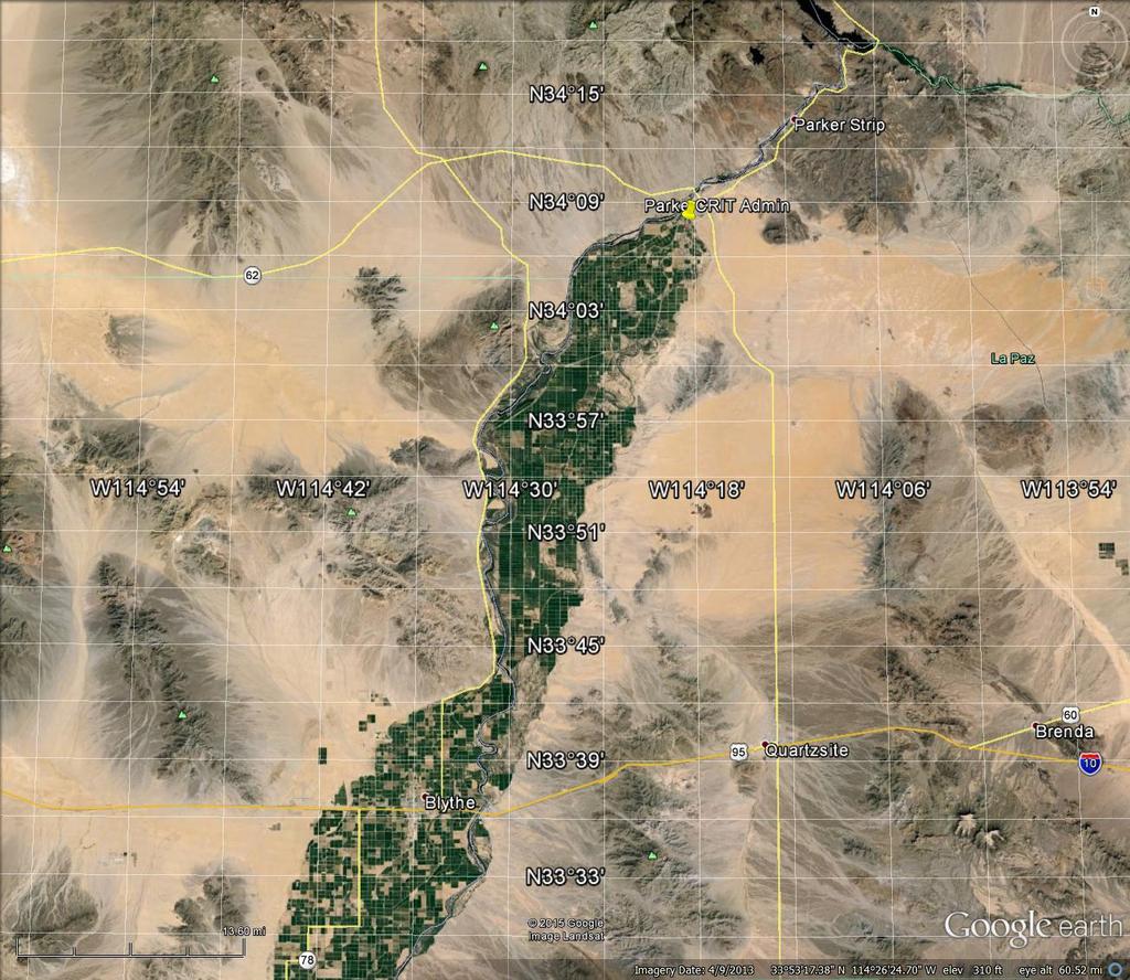
67 2012 ADOT Data La Paz Co. CRIT Area Total Fatalities 18 3 Total Serious Injuries Total Injuries Note: CRIT data is limited to western area only, see Area Map. High Road ENGINEERING, INC. CIVIL ENGINEERING & CONSULTING Transportation Safety Plan Page 3 of 23 Meeting Notes
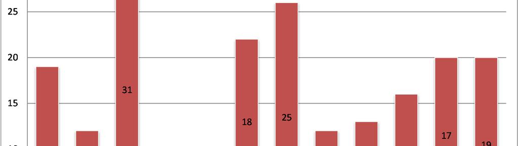
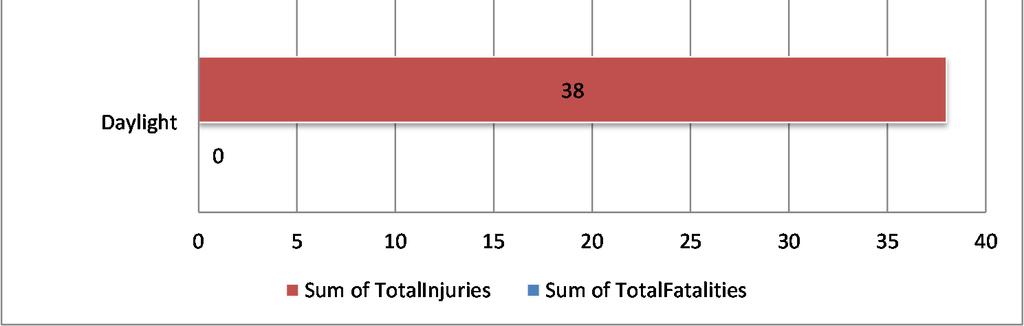
68 Fatal & Severe Crashes for CRIT Area Total Sum of TotalFatalities Sum of TotalInjuries Total Injury Crashes = 71 Total Severe Injury Crashes = 54 Most crashes result in severe injuries! 76% High Road ENGINEERING, INC. CIVIL ENGINEERING & CONSULTING Transportation Safety Plan Page 4 of 23 Meeting Notes
69
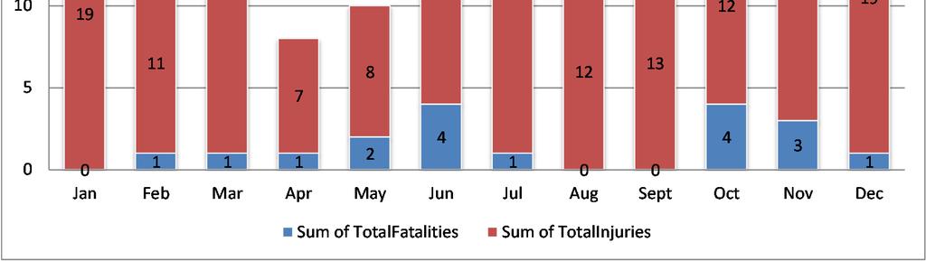
70 14 Fatal & Severe Crashes By Month for CRIT Area Jan Feb Mar Apr May Jun Jul Aug Sept Oct Nov Dec Sum of TotalFatalities Sum of TotalInjuries
71
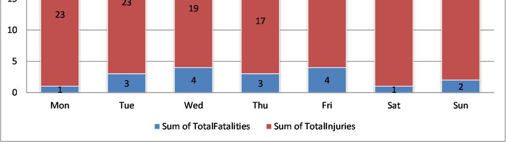
72 25 Fatal & Severe Crashes By Day for CRIT Area Mon Tue Wed Thu Fri Sat Sun Sum of TotalFatalities Sum of TotalInjuries
73
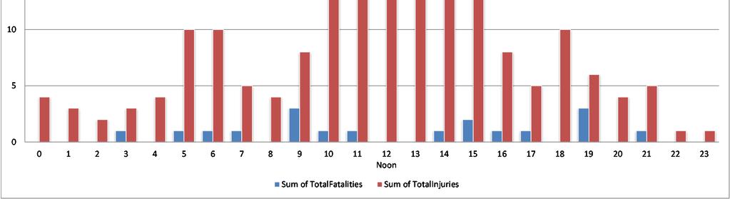
74 12 Fatal & Severe Crashes by Hour for CRIT Area Noon Sum of TotalFatalities Sum of TotalInjuries
75
76
77
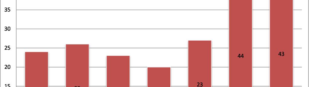
78 San Bernardino 2012 NHTSA Data La Paz Co. Riverside Co. Co. Ranking Total Fatalities Alcohol Related Fatal Crashes Speed Related Fatal Crashes nd Rollover Involved Fatal Crashes rd Roadway Departure Fatal Crashes st Unrestrained Occupant Fatalities Note: Data is for the whole county NHTSA Data Native Am. In Region Total Fatal Crashes 6 Unrestrained 2 Roll-Over 3 Speed Related Fatal Crashes 3 Road Departure 2 Motorcycle 0 Pedestrian Involved 2 Intersection Involved 1 Note: Region is the same as Area Map (See FARS Map also) High Road ENGINEERING, INC. CIVIL ENGINEERING & CONSULTING Transportation Safety Plan Page 14 of 23 Meeting Notes
79 Data Analysis Outcome County Level Data Most fatal crashes involved: 1 st Road Departures 2 nd Speeding 3 rd Rollovers Most fatalities occurred on I-10 or US 95 although a few on local roads Data Analysis Outcome CRIT Area Data Most fatal or severe injury crashes involved: 1 st Rollovers 2 nd Rear end collisions 3 rd Night Conditions Most fatalities occurred on Mohave Road Alcohol involved in 63% of fatal crashes (statewide avg. 33%) Seat belt use 56% (statewide avg. 83%) Data Analysis Outcome American Indian Trauma in Arizona 2011 EMS / Trauma Centers are a long distance away from CRIT Higher trauma rates in rural areas for American Indians Motor Vehicle Traffic related trauma is the highest cause of injury High Road ENGINEERING, INC. CIVIL ENGINEERING & CONSULTING Transportation Safety Plan Page 15 of 23 Meeting Notes
80 5. Determine emphasis areas from analysis / include local projects of concern Data Driven Emphasis Areas at County Level 1) Roadway Departures 2) Speed Management 3) Rollovers 4) SR95, US 95, and Mohave Road highest problems within CRIT Reservation Data Driven Emphasis Areas at Tribal Level 1) Rollovers 2) Rear End Collisions 3) Occupant Protection pass Tribal primary seat belt law 4) Impaired Driving DUIs and pass no phone use law 5) Pedestrian Safety a) Need pedestrian crossings b) Need separate trails (possibly use canal roads) c) Address railroad related fatalities 6) Hazardous Locations / Intersection Improvements a) See RSA locations b) Tsosie Road canal makes a blind spot c) Mohave Road & 2 nd Street people do not stop / run stop sign d) Mohave Road & Indian School Road Head Start traffic e) Mohave Road & AZ SR 95 most fatal crashes are at this location f) Mohave Road & Agency Road g) US 95 & Resort Road (CA) High Road ENGINEERING, INC. CIVIL ENGINEERING & CONSULTING Transportation Safety Plan Page 16 of 23 Meeting Notes
81 h) Cienega Springs Road bad curve (ADOT owned road) i) Mohave Road & Agnes Wilson Road j) Burns Road & 12 th Avenue 7) Speed Management high speed roads are Mohave, US 95 & SR 95 8) Roadway Signage Upgrades a) Need road sign inventory b) Reflectivity upgrades c) Warning signs added (including for farm equipment and dust hazard) d) Guide signs added e) Intersection controls added 9) Pavement Marking Upgrades most roads do not have markings or they need to be repainted (no night-time visibility) 10) Road and Canal Signage guide and location signage needed for response to calls 11) Base Mapping a) 911 addresses b) Latitude/longitude correlated to 911 c) Google Earth not correct (sends you to the wrong location) d) Make maps compatible or able to be used with New World Systems (Police/Fire/EMS system the Tribe uses) 12) Certifications/training for law enforcement, fire, and EMS a) In the State of California, right now CRIT cannot take actions in CA because they are not certified in that state b) Training for New World Systems needed to fully use software High Road ENGINEERING, INC. CIVIL ENGINEERING & CONSULTING Transportation Safety Plan Page 17 of 23 Meeting Notes
82 13) Communications cellular capability does not exist for most of the reservation 14) Development Policy needed to address transportation improvement requirements for new land developments 15) Visitor traffic creates hazards by stopping on road/snowbirds/older drivers 16) Data Collection need a way to assimilate data and tools in place to use the data (no pedestrian information now) 17) Transportation Safety Education Program needs to be developed for a) DUI b) Texting c) Seat belt use / car seat use d) Driver education e) Farming road dangers f) Railroad dangers High Road ENGINEERING, INC. CIVIL ENGINEERING & CONSULTING Transportation Safety Plan Page 18 of 23 Meeting Notes
83 6. Identify strategies for each emphasis area (Think of the Four E s of Safety Engineering, Enforcement, Education, and Emergency Services. Think of the Stakeholders and Partnerships in Transportation who play a role in safety efforts.) Potential Strategies 1) Road Departures o Improve data collection and analysis for fatal run-off-the-road crashes o Increase fines for serious violations that result in run-off crashes o Evaluate pavement strategies (rumble strips, pavement markings) o Shoulder improvements / Recovery zone improvements 2) Speed Management o Develop public outreach o Add signage o Install driver feedback signs / radar ticketing o Increase enforcement (partner with County/ADOT/State) o Increase penalty for repeat offenders o Deliver educational packets for repeat offenders 3) Rollovers o Shoulder improvements / Recovery zone improvements o Evaluate pavement strategies (rumble strips, pavement markings) o Increase seatbelt use High Road ENGINEERING, INC. CIVIL ENGINEERING & CONSULTING Transportation Safety Plan Page 19 of 23 Meeting Notes
84 4) Rear End Collisions o Create media campaigns about distracted driving o Add messaging about following too close/leave room o Reduce speed limits in busy commercial areas o Add left turn lanes or medians 5) Occupant Protection o Conduct outreach to teens o Work with IHSP for child seat use and seat belt technician training o Have child safety seats available to all tribal members give them out o Conduct safety belt checkpoints or surveys 6) Impaired Driving o Reduce roadside distractions o Stress no texting and driving in driver s education classes o Add rumble strips o Increase sobriety checkpoints o Create media campaigns 7) Pedestrian Safety o Education outreach for pedestrians o Road Safety Assessment of key locations o Apply for TTP Safety Funds for trail / sidewalks High Road ENGINEERING, INC. CIVIL ENGINEERING & CONSULTING Transportation Safety Plan Page 20 of 23 Meeting Notes
85 8) Identify Roadway Hazards at specific locations o Inventory canal locations o Engineering analysis of known locations o Use traffic counters for intersection turning movement analysis o Collect speed data 9) Roadway Signage Upgrades o Complete sign inventory o Apply for TTP Safety Funding o Develop priority sign replacement schedule 10) Pavement Marking Upgrades o Work with BIA Agency on paint maintenance of Bureau roads o Work with ADOT and Caltrans on paint maintenance of state roads o Develop Tribal paint maintenance program o Apply for TTP Safety Funding 11) Road and Canal Signage o Create name or numbering system for canal signs o Inventory signs (or lack thereof) to identify needs 12) Base Mapping o Complete GIS maps for all roads and canals throughout the reservation o Incorporate addresses in map for 911 response o Incorporate latitude/longitude in map (make sure all systems are the same) o Work with software developer to use base map with New World Systems High Road ENGINEERING, INC. CIVIL ENGINEERING & CONSULTING Transportation Safety Plan Page 21 of 23 Meeting Notes
86 13) Certifications/training for law enforcement, fire, and EMS o Seek training opportunities through law enforcement funding o Seek training through safety grant funding (IHSP) o Seek training through fire or EMS funding 14) Communications and Response to Accidents o Perform a cellular signal study o CA certifications 15) Development Policy o Work with Inter Tribal Council of Arizona (ITCA) for policy guidance o Work with other Tribes for model policies o Work with other Towns or Cities for model policies 16) Visitor traffic o Add sight-seeing pull outs at key locations o Add Hazardous Road Conditions or Farm Equipment signs o Add Wayfinding signs to better direct visitor traffic o Add Patrolled by Tribal Police signs to deter speeding 17) Data Collection o Identify best practices in crash reporting o Standardize crash reporting policies and protocols for all agencies operating within the jurisdiction o Explore report features within New World Systems software o Work with Chamber of Commerce and School District for pedestrian data o Compile a central database with addition of data annually High Road ENGINEERING, INC. CIVIL ENGINEERING & CONSULTING Transportation Safety Plan Page 22 of 23 Meeting Notes
87 18) Transportation Safety Education Program o Indian Highway Safety Program (IHSP) training opportunities o ITCA training opportunities o IHS training opportunities (child safety seats mandatory at hospital) o Traffic Safety Officer o Add transportation safety articles to Tribal Newsletter o Collaborate with School District for driver education classes o Tribal Annual Meeting 7. Next meeting date October 28, 2015 (Wednesday) at 10:00 am in the BIA Conference Room. High Road ENGINEERING, INC. CIVIL ENGINEERING & CONSULTING Transportation Safety Plan Page 23 of 23 Meeting Notes
88
89 Your Vision & Mission Example Vision Statements: To improve road safety within our communities in order to reduce the number of people being killed and seriously injured. All transportation users arrive safely at their destinations. Zero fatalities on Arizona roads, your life depends on it (the Every One Counts vision). A vision statement describes what the group is striving to achieve. Example Mission Statements: Implement effective transportation safety programs to save lives by fostering communication, coordination, collaboration, and cooperation. Toward Zero Deaths aims to eliminate fatalities on Delaware s roadways through a multiagency approach that utilizes education, enforcement, engineering, and emergency service strategies. The mission statement defines the purpose of the plan, what it does, and what it is about.
90 Your Goals Example Goals: To prevent and reduce the number of people killed and injured in transportation related crashes. Saving lives and preventing serious injuries over the next decade on our local county roads. Reduce the number of fatalities across the state by 15% over the next 5 years. What does the group hope to achieve in a specified amount of time? Goals should be realistic and measurable and can evolve over time.
91
92 Fatalities by Person/Crash Type Fatality Type Fatalities Fatalities Per 100,000 Population Total Fatalities (All Crashes)* (1) Alcohol-Impaired Driving (BAC=.08+) Fatalities (2) Single Vehicle Crash Fatalities (3) Large Truck Involved Crash Fatalities (4) Speeding Involved Crash Fatalities (5) Rollover Involved Crash Fatalities (6) Roadway Departure Involved Crash Fatalities (7) Intersection (or Intersection Related) Crash Fatalities Passenger Car Occupant Fatalities Light Truck Occupant Fatalities Motorcyclist Fatalities Pedestrian Fatalities Bicyclist (or Other Cyclist) Fatalities (1) Crash Involved at Least One Driver or Motorcycle Rider With a BAC of.08 or Above (2) Crash Involved Only One Vehicle In Transport (3) Crash Involved at Least One Large Truck (4) Crash Involved at Least One Vehicle Speeding (5) Crash Involved at Least One Vehicle that Rolled Over (6) Crash Involved at Least One Vehicle that Departed the Roadway (FHWA Definition) (7) Crash Occured Within an Intersection or Within the Approach to an Intersection *A Fatality Can Be in More Than One Category. Therefore Sum of the Individual Cells Will Not Equal the Total Due to Double Counting 2
93 Passenger Vehicle Occupant Fatalities by Restraint Use Restraint Use Fatalities Fatalities Per 100,000 Population Restrained Unrestrained Unknown Restraint Use Total Motorcyclist Fatalities by Helmet Use Helmet Use Fatalities Fatalities Per 100,000 Population Helmet Used No Helmet Used Unknown Helmet Use Total
94 Fatalities by Person Type and Race/Hispanic Origin Person Type by Race/Hispanic Origin Occupants (All Vehicle Types) Hispanic Non-Occupants (Pedestrians, Pedalcyclists and Other/Unknown Non-Occupants) Total White Non-Hispanic Black, Non-Hispanic American Indian, Non-Hispanic/Unknown Asian, Non-Hispanic/Unknown All Other Non-Hispanic or Race Unknown Race and Unknown Hispanic Total Hispanic White Non-Hispanic Black, Non-Hispanic American Indian, Non-Hispanic/Unknown Asian, Non-Hispanic/Unknown All Other Non-Hispanic or Race Unknown Race and Unknown Hispanic Total Hispanic White Non-Hispanic Black, Non-Hispanic American Indian, Non-Hispanic/Unknown Asian, Non-Hispanic/Unknown All Other Non-Hispanic or Race
95 Continuing contents of page 5, which would not fit on a single physical page Person Type by Race/Hispanic Origin Total Unknown Race and Unknown Hispanic Total Race/Hispanic Origin Data is Not Yet Complete
96 Fatalities by Person/Crash Type Fatality Type Fatalities Fatalities Per 100,000 Population Total Fatalities (All Crashes)* (1) Alcohol-Impaired Driving (BAC=.08+) Fatalities (2) Single Vehicle Crash Fatalities (3) Large Truck Involved Crash Fatalities (4) Speeding Involved Crash Fatalities (5) Rollover Involved Crash Fatalities (6) Roadway Departure Involved Crash Fatalities (7) Intersection (or Intersection Related) Crash Fatalities Passenger Car Occupant Fatalities Light Truck Occupant Fatalities Motorcyclist Fatalities Pedestrian Fatalities Bicyclist (or Other Cyclist) Fatalities (1) Crash Involved at Least One Driver or Motorcycle Rider With a BAC of.08 or Above (2) Crash Involved Only One Vehicle In Transport (3) Crash Involved at Least One Large Truck (4) Crash Involved at Least One Vehicle Speeding (5) Crash Involved at Least One Vehicle that Rolled Over (6) Crash Involved at Least One Vehicle that Departed the Roadway (FHWA Definition) (7) Crash Occured Within an Intersection or Within the Approach to an Intersection *A Fatality Can Be in More Than One Category. Therefore Sum of the Individual Cells Will Not Equal the Total Due to Double Counting 2
97 Passenger Vehicle Occupant Fatalities by Restraint Use Restraint Use Fatalities Fatalities Per 100,000 Population Restrained Unrestrained Unknown Restraint Use Total Motorcyclist Fatalities by Helmet Use Helmet Use Fatalities Fatalities Per 100,000 Population Helmet Used No Helmet Used Unknown Helmet Use Total
98 Fatalities by Person Type and Race/Hispanic Origin Occupants (All Vehicle Types) Hispanic Non-Occupants (Pedestrians, Pedalcyclists and Other/Unknown Non-Occupants) Total (Continued) White Non-Hispanic Black, Non-Hispanic American Indian, Non-Hispanic/Unknown Asian, Non-Hispanic/Unknown Pacific Islander, Non-Hispanic/Unknown Multiple Races, Non-Hispanic/Unknown All Other Non-Hispanic or Race Unknown Race and Unknown Hispanic Total Hispanic White Non-Hispanic Black, Non-Hispanic American Indian, Non-Hispanic/Unknown Asian, Non-Hispanic/Unknown Pacific Islander, Non-Hispanic/Unknown Multiple Races, Non-Hispanic/Unknown All Other Non-Hispanic or Race Unknown Race and Unknown Hispanic Total Person Type by Race/Hispanic Origin Hispanic
99 Person Type by Race/Hispanic Origin Total White Non-Hispanic Black, Non-Hispanic American Indian, Non-Hispanic/Unknown Asian, Non-Hispanic/Unknown Pacific Islander, Non-Hispanic/Unknown Multiple Races, Non-Hispanic/Unknown All Other Non-Hispanic or Race Unknown Race and Unknown Hispanic Total Race/Hispanic Origin Data is Not Yet Complete 5
100 Fatalities by Person/Crash Type Fatality Type Fatalities Fatalities Per 100,000 Population Total Fatalities (All Crashes)* (1) Alcohol-Impaired Driving (BAC=.08+) Fatalities (2) Single Vehicle Crash Fatalities (3) Large Truck Involved Crash Fatalities (4) Speeding Involved Crash Fatalities (5) Rollover Involved Crash Fatalities (6) Roadway Departure Involved Crash Fatalities (7) Intersection (or Intersection Related) Crash Fatalities Passenger Car Occupant Fatalities Light Truck Occupant Fatalities Motorcyclist Fatalities Pedestrian Fatalities Bicyclist (or Other Cyclist) Fatalities (1) Crash Involved at Least One Driver or Motorcycle Rider With a BAC of.08 or Above (2) Crash Involved Only One Vehicle In Transport (3) Crash Involved at Least One Large Truck (4) Crash Involved at Least One Vehicle Speeding (5) Crash Involved at Least One Vehicle that Rolled Over (6) Crash Involved at Least One Vehicle that Departed the Roadway (FHWA Definition) (7) Crash Occured Within an Intersection or Within the Approach to an Intersection *A Fatality Can Be in More Than One Category. Therefore Sum of the Individual Cells Will Not Equal the Total Due to Double Counting 2
101 Passenger Vehicle Occupant Fatalities by Restraint Use Restraint Use Fatalities Fatalities Per 100,000 Population Restrained Unrestrained Unknown Restraint Use Total Motorcyclist Fatalities by Helmet Use Helmet Use Fatalities Fatalities Per 100,000 Population Helmet Used No Helmet Used Unknown Helmet Use Total
102 Fatalities by Person Type and Race/Hispanic Origin Person Type by Race/Hispanic Origin Occupants (All Vehicle Types) Hispanic Non-Occupants (Pedestrians, Pedalcyclists and Other/Unknown Non-Occupants) Total White Non-Hispanic Black, Non-Hispanic American Indian, Non-Hispanic/Unknown Asian, Non-Hispanic/Unknown Multiple Races, Non-Hispanic/Unknown All Other Non-Hispanic or Race Unknown Race and Unknown Hispanic Total Hispanic White Non-Hispanic Black, Non-Hispanic American Indian, Non-Hispanic/Unknown Asian, Non-Hispanic/Unknown Multiple Races, Non-Hispanic/Unknown All Other Non-Hispanic or Race Unknown Race and Unknown Hispanic Total Hispanic White Non-Hispanic Black, Non-Hispanic American Indian, Non-Hispanic/Unknown
103 Continuing contents of page 5, which would not fit on a single physical page Person Type by Race/Hispanic Origin Total Asian, Non-Hispanic/Unknown Multiple Races, Non-Hispanic/Unknown All Other Non-Hispanic or Race Unknown Race and Unknown Hispanic Total Race/Hispanic Origin Data is Not Yet Complete
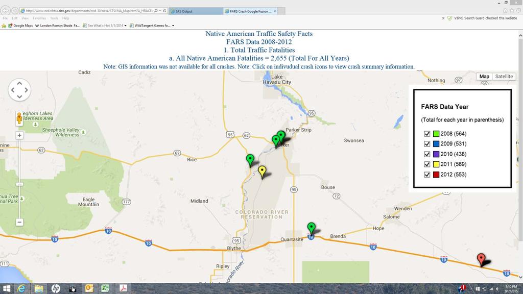
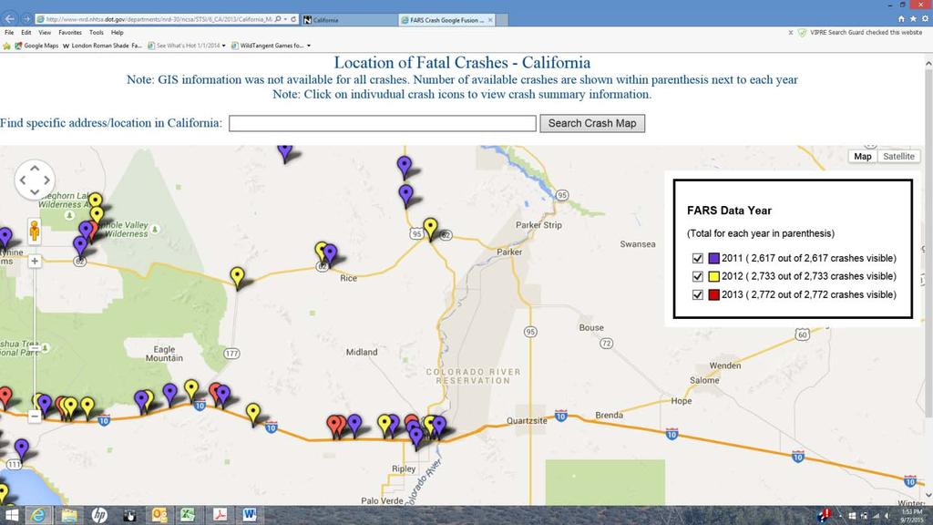
104
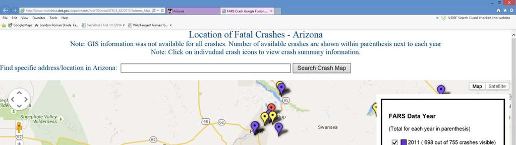
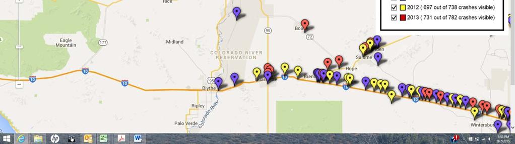
105

106 CRIT Heat Map Arizona Copyright 2011 Esri. All rights reserved. Mon Sep :07:13 PM.
107 CRIT Heat Map California Copyright 2011 Esri. All rights reserved. Mon Sep :09:02 PM.
108 3.7 MOTOR VEHICLE CRASHES CRASH DATA SUMMARY Crash data was compiled from a variety of sources, including previous studies, the Colorado River Indian Tribes Police Department, The Arizona Department of Transportation and the California Department of Transportation. A summary of crash data and trends on key locations with crash histories is provided in Table 18. Table Crash Data Summary for Key Roads and Intersection Crash Data Summary Characteristics for Key Roads and Intersections with Crash History Crash Location Burns Rd between 1st & 4th Ave # of Crashes Fatalities Injuries Summary of Crash Characteristics th Ave & Booth Rd Mohave Rd & Patrick Rd Burns Rd between 12th & 14th Ave California Ave & Agency/Riverside Dr 5 single vehicle, 5 run-off-road, 3 canal, 1 rearend, 2 animal 13 single vehicle, 9 run-off-road, 4 ditch, 2 rearend, 3 curve-related, 4 hit fixed object, 4 roll over, 1 animal 7 single vehicle, 1 ATV, 1 farm vehicle 7 run-offroad, 4 canal, 2 collision w/other vehicle, 3 hit fixed object, 3 roll over single vehicle, 1 backed into canal, 1 roll over th Ave & Little Rd st Ave & 16th St Highway 95/RSD & Airport Rd Mohave Rd & Poston Rd th St & California Ave nd Ave & Mohave Rd single vehicle, 1motor vehicle/pedestrian, 1 motor vehicle/bicycle, 34 collisions w/other motor vehicle (Most crashes involved turning or rear end collisions). The total number of crashes at this intersection is understated. 2 single motor vehicle, 1 rear end, 1 ditch, 2 canal, 1 rollover 3 single vehicle, 1 ATV, 1 motor vehicle/bicycle, 2 run-off-road, 1 rollover, a1 hit fixed object,1angle collision, 2 single vehicle, 1P/U/motor cycle, turning, rear end, backing and head-on collisions, 1run-offroad, 1 rollover. 11 single vehicle, 2 farm vehicle, 7run-off-road, 2 rollover, 5 hit fixed object, 1 animal 1 single vehicle, 2 failures to head stop sign. 2 illegal lane changes, 2 left turn collisions, 1 backing collision. 1 run-off-road 15 single vehicle, 1 vehicle/motorcycle collision, 1 canal, mostly parking lot crashes including several involving backing, 1 failure to stop, 1 failure to yield, 1 ran-off-road and hit fixed object, 1 left turn, 2 angle, 2 rear end, 2 head-on crashes 39
109 Crash Data Summary Characteristics for Key Roads and Intersections with Crash History Crash Location Mohave Road & Agnes Wilson Road Scott Road & Mohave Road 12th Avenue & Agnes Wilson Road Indian School Road & Mohave Road Mohave Road Mileposts 0-9 Mohave Road Mileposts nd Avenue and Agency Road # of Crashes Fatalities Injuries Summary of Crash Characteristics single vehicle, 1 head-on, 3 left turn, 2 rear end crash 1 cross centerline, 2 run-off-road, 1 roll over, 1 animal single vehicle, 1 ran-off-road, 1 rear end single vehicle, 1 ran-off-road, 1 roll over Rio Vista Road Riverside Drive & Wal- Mart/Moovalya Plaza/McDonalds Hopi Road & 11th Avenue Main Canal Resort Drive & Blue Water Casino 2 single vehicle, 2 left turn crash including 1 bus, 2 ran-off-road, 1 roll over, 1 hit fixed object 1 single vehicle, 1U-turn angle crash, 1 run-offroad 5 single vehicle, 1 vehicle/pedestrian, 1 ATV,3 rear end, 2 backing, 1 sideswipe, 3 angle crash, 2 canal, 4 run-off-road, 2 rollover, 1 hit fixed object, 1 hit parked car single vehicle, 3 ran-off-road, 3 hit fixed object single vehicle, 1 vehicle/pedestrian, 1 ran-offroad, 1 rollover 31 single vehicle, 3 vehicle/pedestrian; backing, angle, sideswipe, left turn, head-on, hit parked vehicle, rear end, failed to yield, hit fixed object crashes. Fatal due to heart failure. 3 run-off-- road, 2 rollover single vehicle, 1 ran-off-road Other Canal Crashes Sources: Colorado River Indian Tribes Police Department and Arizona Department of Transportation 23 single vehicle, 2 vehicle/pedestrian crashes, 1auto/motorcycle crash, left and right turns, backing, rear end, hit parked vehicle crashes, 5 run-off-road, 2 rollover, 25 single vehicle, 1 2-vehicle crash on canal bank,7 vehicles found in canal, 3 rollover, 1animal avoidance, 1 roadway failure 40
110 Review of "Colorado River Indian Tribes Road Safety Assessment" The Colorado River Indian Tribes Road Safety Assessment" (April, 2013, prepared by the Arizona Road Safety Assessment Program, Arizona Department of Transportation), was prepared at the request of the CRIT. It addressed four roads and ten locations shown in Table 19. A summary of the identified needs and countermeasures for consideration are summarized in Table 20. The Colorado River Indian Tribes Road Safety Assessment Report is provided in Appendix B. Table 19 - Roads and Locations addressed in Colorado River Indian Tribes Road Safety Assessment Road Location Mohave Road Mileposts 0-9 Patrick Road Intersection Poston Road Intersection Agnes Wilson Road Intersection Mileposts Burns Road 1st Avenue to 4th Avenue 12th Avenue to 14th Avenue 4th Avenue Indian School Road Booth Road 2nd Avenue Agency Road Source: Colorado River Indian Tribes Road Safety Assessment" (April, 2013) A total of 79 crashes at the RSA locations were found in the ADOT Safety Data Mart (formerly ALISS) for the years 2000 to 2012 and were analyzed for severity, crash type, light conditions, fatal crash type, fatal crash location, and crashes by year. In addition, education, enforcement and medical services were discussed. 41
111 Table 20 Road Safety Assessment Findings Potential Safety Issue Education, Enforcement, and EMS Pavement Markings Description Traffic safety issues cannot be solved with engineering solutions alone, which is why the RSA team addresses the 4 Es of safety: engineering, education, enforcement, and EMS. Centerline and edgeline markings are faded or non-existent on many of the roads in the study area, including: o Mohave Road between mileposts 0 and 9 o Burns Road o Booth Road o 4th Avenue o Indian School Road Countermeasures For Consideration Require Tribal employees to use seatbelts when in a tribal vehicle Enact a primary seat belt law and consider stronger child passenger safety laws (at minimum, CRIT should align their child passenger safety ordinance to mirror Arizona s statute ARS ). Advocate to the town of Parker that adding 24/7 fire department coverage is a necessary public safety benefit; at minimum, CRIT should conduct a cost benefit analysis to determine the costs of providing fire department coverage to the Town of Parker. Use only the contracted air ambulance provider (Native Air) and if a situation arises when the non-contracted air ambulance (Care Flight) must be used, the providers should document why this decision was made. The documentation will allow Indian Health Service to assess the provided contracted services. Conduct quarterly meetings of the multiple law enforcement agencies serving the community to discuss mutual issues. Continue with the child passenger safety efforts of the TIPCAP and CDC funded motor vehicle projects, and consider addressing adolescent traffic safety using the Battle of the Belt. Install 6-inch wide centerline and edge line markings with centerline raised pavement markers (RPMs) on the southern section of Mohave Road (milepost 0 to 9), Burns Road, Booth Road, 4th Avenue, and Indian School Road. If centerline and edge line markings can t be installed, consider installing centerline RPMs at canal crossings and through curves. There are also missing raised pavement markers (RPMs) on some segments of road. Lack of pavement markings can contribute to lane departure crashes. Signing Most advance street name signs on Mohave Road are faded and difficult to read. Upgrade advance street name signs to Manual on Uniform Traffic Control Devices (MUTCD) standards. 42
112 Potential Safety Issue Description Countermeasures For Consideration Stop Lines Most stop lines are faded and located too far back from the intersection, limiting sight distance for motorists on the side road. For example, the stop line for the Tsosie Road westbound approach to Mohave Road is located 42 feet from the intersection; combined with an embankment, this creates a sight obstruction for motorists entering the intersection from the stop line. Refresh and relocate stop lines closer to the intersection (the MUTCD allows stop lines to be located within four feet of the intersecting through lane). Pedestrians and Bicyclists Burns Road from 1st to 4th Avenue Burns Road from 12 th to 14 th Avenue There are very few accommodations for pedestrians and bicyclists: no trails, sidewalks, or bike lanes. Other than the bridge barrier and railing, there is nothing to keep vehicles that run off the road while approaching the canal crossing from plunging into the canal. The drainage ditch on the south side of Burns Road just east of 4th Avenue is in the recovery area and near an unpaved travel area. As with the canal crossing east of 4th Avenue, there is nothing to keep vehicles that run off the road while approaching the canal crossings east of 13th and 14th Avenues from plunging into the canal. There are inadequate post connections at the 12th Avenue bridge guardrail: bolts are loose and pulling away from the concrete The object markers along the north side of the headwall east of 13th Avenue are in the wrong location; according to the MUTCD, the edge of the object marker that is closest to the road user shall be installed in line with the closest edge of the obstruction. The westbound direction of Burns Road has a Narrow Bridge sign for the 12th Avenue bridge, but there is no sign for the eastbound direction. Construct sidewalks/trails and install lighting along 1st Avenue from Mohave Road to Hospital, along Mohave Road from 1st to 2nd Avenues, and from the Mochem housing near Booth Road and 4th Avenue to the tribal offices on 2nd Avenue. Coordinate with BIA Irrigation Branch to provide walking and biking facilities along the canals. Install barrier extending from the bridge to along the side of the canal approximately 30 feet; if this can t be done, install object markers along the side of the canal. Install delineators to delineate the drainage ditch just east of 4th Avenue. At the canal crossings east of 13th and 14thAvenues install curved W- Beam guardrail extending from the crossing to approximately 30 feet along the side of the canal; if this cannot be done, install object markers along the side of the canal. Repair post connections at the 12th Avenue bridge. Relocate object markers at the headwall east of 13th Avenue. Install Narrow Bridge sign for westbound direction at 12th Avenue bridge. 43
113 Potential Safety Issue 2nd Avenue at Agency Road 4th Avenue at Indian School Road Description 2nd Avenue becomes Agency Road north of Mohave Road in a horizontal curve. The Tribal planner indicated that some motorists enter this curve at excessive speeds. The northbound approach to the curve has transverse rumble strips to encourage motorists to slow down before entering the curve. The southbound approach has a curve warning sign. Guardrail and chevrons have been installed along the curve; however, it appears that the guardrail and chevrons do not extend to the end of the curve on the south side. This intersection is actually a sharp horizontal curve with stop signs. Field observations showed that many drivers do not stop at the unwarranted stop signs. Wooden barricades within the clear zone on the south side of the curve are not breakaway. Graffiti-covered large arrow signs and stop sign are difficult to see. The irrigation ditch is 6 feet from the edge of the road along the turning radius. Countermeasures For Consideration Extend the guardrail through the curve at the bottom of the hill. Install additional chevron(s) through the curve at the bottom of the hill. Install transverse rumble strips at the top of the hill where guardrail starts. Install northbound curve warning sign with appropriate advisory speed plaque, and add advisory speed plaque to southbound curve sign. Add reflective tabs to top of guardrail posts. Remove stop signs, stop ahead signs, stop lines, and wooden barricades. Install turn warning signs with appropriate advisory speed plaques. Replace and relocate large arrow signs so they are in line with approaching traffic. Install centerline markings and RPMs and edge lines through curve. Install transverse rumble strips on the curve approaches. 4th Avenue at Booth Road Mohave Road Southern Section (Mileposts 0 to 9) 4th Avenue becomes Booth Road in a horizontal curve. Transverse rumble strips have been installed on the curve approaches. There are multiple unpaved accesses within the curve that lead to the canal roads. A concrete barrier has been placed across one of the accesses apparently to prevent vehicles from entering; however, vehicles can maneuver around the barrier due to its location and gain access to the canal road. Chevrons on the east side do not extend to the end of the curve. Chevron spacing through the curve is approximately 200 feet. The MUTCD recommends chevron spacing of 120 feet for curve speeds of 35 to 45 mph. The pavement markings on the southern section of Mohave Road (mileposts 0 to 9) are faded or non-existent and the pavement is aged. The Welcome sign at milepost 0 is faded and may not command driver attention. Gateway signing can have a traffic calming influence on motorists entering a community. Relocate access road barrier closer to 4th Avenue to prohibit entrance. Reduce chevron spacing to 120 feet and extend chevrons through the curve east along Booth Road. Limit number of accesses to the canal roads in this curve. Rehabilitate the pavement with a chip seal treatment. Install centerline markings and RPMs and edgeline markings to provide 11-foot lanes and 4 foot shoulders. Install centerline and edgeline rumble strips. Install a new Welcome to CRIT monument sign at milepost 0. 44
114 Potential Safety Issue Mohave Road at Poston Road Description This location has turning movements and pedestrian activity due to Woody s convenience store, post office, residences, and the Poston Memorial Monument that are in the immediate vicinity. The intersection has uncontrolled access on all 4 quadrants. Large trucks parking at Woody s create a sight obstruction. Countermeasures For Consideration Install pedestrian crossing warning signs on the Mohave Road approaches. Refresh pavement markings (turn lanes, edgelines, centerlines). Construct sidewalks/curb and gutter along the intersection legs. Upgrade street lighting. Mohave Road at Patrick Road Mohave Road at Agnes Wilson Road Mohave Road at the Head Start School Even though there are some street lights in the area, the intersection is not well-lit at night. It is difficult to see the Patrick Road intersection from the northbound approach due to the canal crossing and guardrail. The guardrail on the east side of the crossing has been damaged. The curb in front of the guardrail reduces crashworthiness of the guardrail. There is no barrier to keep vehicles that run off the road from striking the concrete structure or falling into the canal. Chevron spacing in the curve is approximately 250 feet; the MUTCD recommends 160 foot spacing for curve speeds of 50 to 60 mph. The team observed higher speeds (55 mph speed limit), higher volumes, and more numerous turning movements at this intersection than at other intersections on Mohave Road. Commercial activity at the intersection includes the truck scales, which creates a high amount of large truck activity. The left-turn lanes on Mohave Road are approximately 180 feet long (including taper and storage length), which is too short for the current operating speeds. The turn lane pavement markings are faded. There are two closely spaced intersection warning signs (both directions between Agnes Wilson Road and Patrick Road) for Eddy Road and 9th Avenue. The speed limit at the Head Start School is 45 mph; however, a spot speed check conducted by the RSA team showed many vehicles traveling at speeds of 55 to 60 mph in front of the school. Even though there is a no passing zone at the school, the RSA team vehicle was passed (while traveling at the speed limit). There is no defined access at the school, leading to vehicles pulling on and off of Mohave Road at multiple locations. Vehicles pulling onto the shoulder at the mailboxes just north of the school (southwest corner of Mohave Road/Indian School Road intersection) lead to shoulder erosion and create a potential hazard for motorists along Mohave Road. Extend guardrail on northbound approach to prevent errant vehicles from striking the concrete structure. Extend guardrail on southbound approach and relocate Patrick Road approach approximately 150 feet north. Repair damaged guardrail and posts. Block out guardrail to position the guardrail face flush with the curb. Reduce chevron spacing to 160 feet by installing additional chevrons. Install reflective tabs on guardrail posts. Reduce the speed limit to 35 mph. If the speed limit is not reduced, increase the length of the left-turn lanes. Refresh intersection pavement markings. Replace intersection warning signs for Eddy Road and 9th Avenue with Double Side Road intersection warning signs. Create a reduced speed school zone and install solar powered 35 MPH When Flashing signs. Implement photo enforcement for speeding. Relocate mailboxes to a cluster mailbox approximately 100 feet west of Mohave Road on the north side of Indian School Road. Designate a defined school entrance on Indian School Road, and close the undefined access along Mohave Road (with curb and gutter, vegetation, etc.). 45
115 Potential Safety Issue Mohave Road at 2nd Avenue Mohave Road at 1st Avenue Description Tribal offices are located at this intersection, and the rodeo grounds and a park are nearby, leading to numerous turning movements and pedestrian activity. The intersection is dark at night due to lack of street lighting. The speed limit decreases from 55 to 35 mph for the northbound approach and from 45 to 35 mph for the southbound approach; the Tribe noted that excessive speeds are an issue at this location. The flashing beacon is 14.5 feet above the road surface; the MUTCD states that the bottom of the signal housing shall be at least 15 feet above the pavement. This beacon has been struck by large vehicles in the past. There are no turn lanes on Mohave Road at 1st Avenue; the Tribe indicated that there are frequent turning movements at this intersection. The intersection is at the bottom of a downgrade and just beyond a horizontal curve for westbound traffic. The westbound Mohave Road speed limit changes from 45 to 35 mph on the downgrade and in the horizontal curve. There are redundant Speed Reduced Ahead and 35 mph Speed Zone signs for westbound Mohave Road east and west of 1st Avenue. Countermeasures For Consideration Install a 45 mph speed zone between the 55 and 35 mph speed zones for the northbound approach (install 45 mph sign south of Rodeo Road). Install solar-powered speed feedback signs on the approaches to 2nd Avenue. Elevate the flashing beacon; remove beacon if it can t be elevated. Install street lighting. Install pedestrian crossing warning signs on Mohave Road. Refresh intersection pavement markings. Install guide signing for Tribal Government Complex. Conduct pedestrian crossing evaluation to determine if a mid-block pedestrian crossing treatment is warranted. Conduct a turn lane analysis, and if needed, construct turn lanes on Mohave Road at 1st Avenue. Relocate the 35 mph Speed Zone sign and Speed Reduced Ahead sign for westbound Mohave Road to a location east of the horizontal curve and downgrade. Remove the Speed Reduced Ahead sign west of 1st Avenue. 46
116 3.7.2 ROAD SPECIFIC MOTOR VEHICLE CRASHES Using crash data from 2004 through 2012, Table 21 shows the total number of crashes occurring over that nine year period for several high volume or other important roads. Crashes at the canals, Casino Drive and Moovalya Plaza areas are also shown. The number of crashes, combined with high crash location information provided in previous tables, provides an indication regarding roads that might be considered for further crash studies. Table 21 - Total Number of Crashes for Roads on CRIT or with Significance to CRIT Road # of Crashes Road # of Crashes Road # of Crashes 1st Ave 36 Airport Dr 3 Joshua Ave 10 2nd Ave 39 Arizona Ave 12 Kofa Ave 10 4th Ave 34 Blue Water Dr 41 Little Rd 5 7th Ave 6 Casino Dr 3 McCabe Rd 7 9th Ave 4 Resort Dr 70 Mohave Rd th Ave 4 Booth Rd 9 Moovalya Pl 62 12th Ave 2 Burns Rd 7 Navajo Ave 8 14th Ave 7 Calif. Ave 61 Patrick Rd 2 15th St 13 Riverside Dr 130 Peterson Rd 5 16th St 21 Hwy Poston Rd 5 18th St 9 Canal 15 Shea Rd 3 Agency Rd 31 Main Canal 17 Agnes Wilson 3 Indian School 3 Sources: Indian Health Service and CRIT Police Department CALIFORNIA CRASHES The California Department of Transportation provided the data provided in Table 22 for motor vehicle crashes on US 95 from its intersection with Interstate 10 in Blythe to SR 62 at Vidal Junction and on SR 62 from Vidal Junction to the Colorado River Bridge at Parker. The data span the 10-year period from 2002 through Most of these sections of highway are not within the CRIT Reservation, but are utilized by tribal members living in California. It should be noted that about 45 percent of the crashes 47
117 on these roads involve fatalities or injuries. Many of the crashes in and near tribal lands involved vehicles overturning or sideswiping. Table 22 - Summary of Motor Vehicle Crash Data on US 95 and SR 62 on and Near the Colorado River Indian Tribes Reservation (Years ) Road and Section Total # of Crashes # of Fatal Crashes # of Injury Crashes # of PDO* Crashes Total Fatalities Total Injuries US 95 Riverside Co. PM US 95 San Bernardino Co. PM (Vidal Junction) SR 62 PM (Vidal Jct.) (Colorado River Bridge Totals Source: California Department of Transportation *property damage only RECOMMENDATIONS FROM CRASH ANALYSIS 1. SR 95, including the California Avenue and Riverside Drive segments, and Mohave Road have the highest number of crashes on any roads on or impacting the CRIT Reservation. The development of corridor studies should be considered for the full length these roads to identify needed safety improvements and other operational improvements for these important roads. 2. There are high numbers of crashes involving canals and in and adjacent to the Blue Water Casino and the Moovalya Plaza. Consider conducting Road Safety Assessments at these locations to identify strategies to reduce the number and severity of crashes at these locations. 3. CRIT should consider implementing the recommendations of the Colorado River Indian Tribes Road Safety Assessment conducted by ADOT. 4. Consider full road length Road Safety Assessments for some of the other roads, such as 1st Avenue, 2nd Avenue, 4th Avenue and Agency Road that have high crash rates. 5. CRIT should enter in discussions with Caltrans to determine ways to reduce the percentage of fatal and injury crashes on US 95 and SR


118 3.7.5 SAFETY FOCUSED EDUCATION EFFORTS Improved traffic safety education, by incorporating safety into school curriculum at all levels of school, was identified through discussions with stakeholders and the Tribal Planner. Age appropriate programs can be developed for all age groups, for example: Pre-school and elementary school topics: Seat belt use Pedestrian and bicycle safety o o How to cross the street safely stop, look, and listen Basic bike and helmet fitting especially important for parents o How to position yourself properly on the road the three positions o How to let drivers know your intentions be predictable o How to safely negotiate turns and intersections hand signals, signs, traffic awareness o The basics of traffic law right-of-way and rules of the road o Skills practice Three to six adult-led hours on a bike; one hour walking in a neighborhood School bus safety Unsafe rides Middle School and High School topics: Upper grades could focus on more driver-oriented messages, such as: No texting and driving Don t Drink and Drive Buckle Up - it could save your life 49
119 Ampadu, IHS, Laryn Welsh, BIA, and Michael Driscoll, American Medical Response. Observations and potential opportunities for improvements were discussed during this meeting. Physical Roadway Characteristics Mohave Road, Burns Road, 4 th Avenue, and 2 nd Avenue are 2-lane roads. Traffic volumes were not available for these roads. Speed limits are as follows: Mohave Road: 55 mph (35 mph at Poston Road, 2 nd Avenue, and 1 st Avenue, 45 mph north of 1 st Avenue) Burns Road: 45 mph 4 th Avenue: 45 mph (35 mph at Booth Road) 2 nd Avenue: 45 mph (35 mph at Agency Road) Evaluation of Crash Data For the crash data analysis, the most recent thirteen years of crash data (2000 through 2012) was collected from the ADOT Information Technology Group s Safety Data Mart, which is ADOT s crash database. Following is a summary of the crashes that occurred during this time period. The following crash data is for: Mohave Road (69 crashes, 13 fatal crashes) Burns Road: 1 st Avenue to 4 th Avenue, 12 th Avenue to 14 th Avenue (4 crashes, 1 fatal) 4 th Avenue at: Indian School Road, Booth Road (2 crashes) Agency Road at 2 nd Avenue (1 crash) 76 crashes Severity: 14 fatal crashes 5 incapacitating injury 7 non-incapacitating injury 10 possible injury 40 property damage only Crash Type: 14 rollover (18%) 14 rear-end (18%) 13 fixed object (17%) 9 angle (12%) 6 sideswipe same direction (8%) 4 other non-collision (5%) 3 sideswipe opposite direction (4%) 3 head-on (4%) 2 left-turn (3%) 1 pedestrian (1%) 1 bicyclist (1%) 6 other (8%) CRIT Road Safety Assessment 5
120 Light Conditions: 55% daylight 37% dark 8% dawn/dusk Fatal Crash Type (14 fatal crashes, 20 fatalities): 5 overturn 3 angle 1 head-on 1 sideswipe opposite direction 1 rear-end 1 pedestrian 1 immersion 1 other fixed object Fatal Crash Locations by Milepost: MP 6 MP 20.3 MP 23 MP 23.9 MP 24 MP 27 MP 29 MP 36.7 MP 37 MP 38 (2) MP 38.3 MP 38.6 Burns Road at 14 th Ave Crashes by Year: 2000: 15 crashes 2001: 14 crashes 2002: 14 crashes 2003: 12 crashes, 1 fatal 2004: 4 crashes, 1 fatal 2005: 1 crash 2006: 3 crashes, 3 fatals 2007: 3 crashes, 2 fatals 2008: 2 crashes, 2 fatals 2009: 3 crashes, 2 fatals 2010: 0 crashes 2011: 5 crashes, 3 fatals 2012: 0 crashes CRIT Road Safety Assessment 6
121 Data from Building a Foundation for Motor Vehicle Crash Injury Reduction on the Colorado River Indian Tribes Reservation IHS report indicates that alcohol is involved in: 24% of all crashes, compared to statewide average of 5% 39% of injury crashes, compared to statewide average of 8% 63% of fatal crashes, compared to statewide average of 33% The report also estimated seatbelt usage at 56%, compared to the statewide average of 83%. Site Review Observations and Initial Recommendations Education, Enforcement, and Emergency Medical Services Traffic safety issues cannot be solved with engineering solutions alone, which is why the RSA team addresses the 4 Es of safety: engineering, education, enforcement, and emergency medical services. This multidisciplinary approach is beneficial and can lead to leveraging of resources in these resource challenged times. Preventability is determined by whether something could have been done (by an individual such as the caretaker or supervisor, or by the community as a whole) that would have prevented the death or injury. Preventing injuries and death is not always achievable and there are many challenges to implementing successful prevention interventions. The greatest challenge is to change behavior of individuals, followed by identification of funding streams for programs, limited people resources, apathy from individuals/community and the belief that bad things will happen to others but not to me. On Going Prevention Efforts: The Colorado River Indian Tribes have strong concern for the crashes that occur in the community as illustrated by the request to have this RSA. Efforts have occurred to ensure that homes in the community are numbered in order for public safety to locate and respond in the event of an emergency. The tribe has a 24/7 staffed fire department that provides first response for both tribal and non-tribal emergencies. The tribal police department has begun to use the state traffic crash report form which will allow uniformity with data collection. La Paz Regional Hospital is a Level IV trauma center and the community of Parker has two air ambulance companies (Native Air and Care Flight); ground emergency medical services are provided by a private ambulance service (American Medical Response). American Indians and Alaska Natives (AI/AN) are at increased risk of motor-vehicle related injury and death with rates 1.5 to 3 times higher than rates for other Americans. To address this disparity, CRIT has received funding from the CDC s Injury Center to tailor, implement, and evaluate evidence-based interventions to reduce motor vehicle-related injury and death in their communities. Additionally, CRIT has an Indian Health Service Tribal Injury Prevention Cooperative Agreement Program (TIPCAP) that provides multi-year funding to hire a full-time Injury Prevention Coordinator and to develop programs based on effective strategies or best practices in injury prevention. Both of these programs are demonstrating the value of having paid staff to address traffic safety and community injury prevention issues. CRIT Road Safety Assessment 7
122 CRIT Tribal Transportation Safety Planning Wednesday, October 28, 2015 at 10:00 am Social Services Conference Room, Parker, AZ Meeting Notes 1. Introductions Sign In Sheet attached 2. Review Meeting Notes from September 9, No comments. 3. Complete Vision, Mission Statement, and Goals Greg Fisher is working on the statements for everyone s consideration. He will send out the proposed statements early next week requesting input. Suggested Vision Statement: Don t Be a Statistic! The Tribe can have a corner of their newspaper dedicated to the Statistic Corner for traffic safety information. 4. Present crash data analysis See Power Point presentation attached. Further comments include roads of concern for the Tribe that are: Agency Road at Navajo and Mohave Road Add rumble strips perpendicular across road prior to stop signs. Several times a year the sun angle blinds the driver s vision and they cannot see the stop sign. Witnesses see people going through stop signs at these locations. Mohave Road needs rumble strips longitudinally along centerline of road. 5. Review all emphasis areas from analysis / include local projects of concern Emphasis area descriptions were presented to the group. One emphasis area, Certifications/Training for Law, Fire & EMS in California, was combined into Communications and Response to Accidents. The proposed emphasis areas are attached.
123 6. Review strategies for each emphasis area and identify approach to implement - Proposed strategies were presented to the group. The suggested additions were noted and added to the worksheets. The updated strategies are attached. 7. Prioritize implementation strategies - A list of emphasis areas were presented to the group. Members submitted their priority list and discussed the reasoning for their choices. The submittals were analyzed and the median rankings are shown on the following page. 8. Next Steps: a. Include CRIT crash data b. Write Draft Safety Plan c. One last meeting to review Safety Plan
124 Priority CRIT Safety Plan Emphasis Area Priorities Emphasis Area 1 Speed Management 2 Impaired Driving 3 Road Departures / Rollovers 4 Roadway Signage Upgrades 5 Pavement Marking Upgrades 6 Hazardous Locations/Intersections 7 Communications/Response to Accidents 8 Occupant Protection /Restraint Use 9 Development Policy 10 Data Collection 11 Pedestrian Safety 12 Road and Canal Signage 13 Rear End Collisions 14 Base Mapping 15 Visitor Traffic 16 Transportation Safety Education Program


125 Colorado River Indian Tribes Elisabeth Whitlock, PE Phone: CIVIL ENGINEERING & CONSULTING
126 Colorado River Indian Tribes Safety Plan October 28, Review Meeting Notes from Sept 9, Complete Vision, Mission Statement, and Goals 3.Present crash data analysis 4.Review all emphasis areas from analysis/include local projects of concern 5.Review strategies for each emphasis area and identify approach to implement 6.Prioritize implementation strategies
127 Questions or comments? Many sources of data 17 Emphasis Areas - has everything been captured? We will now expand on strategies to improve traffic safety
128 Your Vision & Mission Example Vision Statements: To improve road safety within our communities in order to reduce the number of people being killed and seriously injured. All transportation users arrive safely at their destinations. Zero fatalities on Arizona roads, your life depends on it (the Every One Counts vision). A vision statement describes what the group is striving to achieve. Example Mission Statements: Implement effective transportation safety programs to save lives by fostering communication, coordination, collaboration, and cooperation. Toward Zero Deaths aims to eliminate fatalities on Delaware s roadways through a multiagency approach that utilizes education, enforcement, engineering, and emergency service strategies. The mission statement defines the purpose of the plan, what it does, and what it is about.
129 Your Goals Example Goals: To prevent and reduce the number of people killed and injured in transportation related crashes. Saving lives and preventing serious injuries over the next decade on our local county roads. Reduce the number of fatalities across the state by 15% over the next 5 years. What does the group hope to achieve in a specified amount of time? Goals should be realistic and measurable and can evolve over time.
130 December and July have peek crashes Weekends have higher crash rates, BUT fatal crashes scattered Injury crashes occurring during mid-day Fatal crashes occurring at night
131 2012 ADOT Data La Paz Co. CRIT Area Total Fatalities 18 3 Total Serious Injuries Total Injuries Total Injury Crashes = 71 Total Severe Injury Crashes = 54 Most crashes result in severe injuries! 76%
132 Roadways with the highest Fatal & Severe Crashes o State Route 95 o US Highway 95 o Mohave Road o Riverside Drive o Resort Drive o Cienega Springs Road o State Route 62 o Interstate 10
133 Data Analysis Outcome CRIT Area Data Most fatal or severe injury crashes involved: 1 st Rollovers 2 nd Rear end collisions 3 rd Night Conditions Most fatalities occurred on Mohave Road Alcohol involved in 63% of fatal crashes (statewide avg. 33%) Seat belt use 56% (statewide avg. 83%)
134 Road Departures / Rollovers Rear End Collisions Occupant Protection /Restraint Use Impaired Driving Pedestrian Safety Hazardous Locations/Intersections Speed Management Roadway Signage Upgrades Road and Canal Signage Base Mapping Certs/Training for Law, Fire, & EMS Communications Development Policy Visitor Traffic Data Collection Transp. Safety Education Program Pavement Marking Upgrades
135 What is possible? Be realistic Emergency Response Think short and long term Remember 4-E s of Safety Engineering Safety Plan Education Enforcement

136 1. Include CRIT crash data 2. Update Emphasis Area Priorities 3. Write Draft Safety Plan 4. One last meeting to review Safety Plan
Toward Zero Deaths. Regional SHSP Road Show Meeting. Virginia Strategic Highway Safety Plan. presented by
 Toward Zero Deaths Regional SHSP Road Show Meeting presented by Virginia Strategic Highway Safety Plan December 1, 2016 1 Welcome & Introductions Purpose of the Meeting Objectives & Key Outcomes Agenda»
Occ c u c pa p n a t pro r t O ec e t c i t O i n
 Occupant Protection Occupant Protection Introduction Buckling up or being buckled in is the most effective protection during a car crash. The simple truth is that the great majority of people ejected from
A Strategic Highway Safety Plan. a coordinated and informed approach to reducing highway fatalities and serious injuries on all public roads.
 Introduction A Strategic Highway Safety Plan is a coordinated and informed approach to reducing highway fatalities and serious injuries on all public roads. A Strategic Highway Safety Plan is Based on
Closing Plenary Session
 TRAFFIC SAFETY CONFERENCE Closing Plenary Session June 9, 2017 Las Colinas, TX Order of Report Out June 9, 2017 Las Colinas, TX Distracted Driving Prioritized Countermeasures Countermeasure 4a Systemically
City of San Diego Vision Zero Draft Strategic Plan FY 2017
 City of San Diego Vision Zero Draft Strategic Plan FY 2017 Engineering Objective: To develop and implement a strategy that employs best planning, design and engineering practices. Background: Over the
MEMORANDUM. City Constituents. Leilani Schwarcz, Vision Zero Surveillance Epidemiologist, SFDPH
 MEMORANDUM TO: FROM: CC: City Constituents Leilani Schwarcz, Vision Zero Surveillance Epidemiologist, SFDPH Megan Wier, Co-Chair, San Francisco Vision Zero Task Force, SFDPH Commander Ann Mannix, Traffic
An Overview of Traffic Records. April 15, 2016 John Riemer
 An Overview of Traffic Records April 15, 2016 John Riemer What is traffic records? The traffic records office is required by state statue to maintain a database of motor vehicle crashes that occur on all
What Engineering Can Do for You! Low Cost Countermeasures for Transportation Safety
 What Engineering Can Do for You! Low Cost Countermeasures for Transportation Safety Adam Larsen Safety Engineer Federal Highway Administration 360-619-7751 Adam.Larsen@DOT.GOV Adam Larsen TTP Safety Engineer
BIKE PLAN CONTENTS GATEWAY
 CONTENTS Acknowledgments...vii Great Rivers Greenway District Board of Directors... vii Great Rivers Greenway District Staff... vii Project Consultants... vii Committees... viii Citizens Advisory Committee
BIA INDIAN HIGHWAY SAFETY PROGRAM FY2016 LAW ENFORCEMENT GRANT. SECTION A: General Information. This section must be completed for all applicants.
 SECTION A: General Information. This section must be completed for all applicants. Name of Tribe: Click here to enter text. Address : Click here to enter text. City: Click here to enter text. State: Click
BIA INDIAN HIGHWAY SAFETY PROGRAM FY2016 LAW ENFORCEMENT OVERTIME GRANT
 SECTION A: General Information. This section must be completed for all applicants. Name of Tribe: Click here to enter text. Address : Click here to enter text. City: Click here to enter text. State: Click
Engineering Countermeasures for Transportation Safety. Adam Larsen Safety Engineer Federal Highway Administration
 Engineering Countermeasures for Transportation Safety Adam Larsen Safety Engineer Federal Highway Administration 360-619-7751 Adam.Larsen@DOT.GOV Countermeasure Selection Resources Manual for Selecting
Toward Zero Deaths: Proactive Steps for Your Community
 Est. Dec. 2014 Toward Zero Deaths: Proactive Steps for Your Community Presented by: Brian Roberts, P.E., National Association of County Engineers Marie Walsh, Ph.D., Louisiana Local Technical Assistance
Mission: The mission of FARS is to make vehicle crash information accessible and useful so that traffic safety can be improved
 Mission: The mission of FARS is to make vehicle crash information accessible and useful so that traffic safety can be improved NHTSA created FARS in 1975 National Center for Statistics and Analysis (NCSA)
Lessons Learned from the Minnesota County Road Safety Plans. Richard Storm CH2M HILL
 Lessons Learned from the Minnesota County Road Safety Plans Richard Storm CH2M HILL May 21, 2014 Overview of the MN CRSP: Why Prepare Safety Plans for Local Systems? MAP-21: Requires states to address
road safety issues 2001 road toll for Gisborne district July 2002 Road user casualties Estimated social cost of crashes*
 GISBORNE DISTRICT road safety issues July 22 The Land Transport Safety Authority (LTSA) has prepared this Road Safety Issues Report. It is based on reported crash data and trends for the 1997 21 period.
17 th Annual Northwest Tribal Transportation Symposium April 21, 2010 Northwest Region Division of Transportation Bureau of Indian Affairs
 17 th Annual Northwest Tribal Transportation Symposium April 21, 2010 Northwest Region Division of Transportation Bureau of Indian Affairs Strategic t Highway Safety Plan for Indian Lands (SHSP) Washington
Canadian Association of Chiefs of Police Association canadienne des chefs de police
 WHAT S IN THE KIT? Media Advisory Template To be used to invite the media to an event during Operation Impact. We suggest you reproduce this on your own police agency letterhead. News Release Template
Street Smart - Regional Pedestrian Safety Campaign. Hopkins Grand Rounds July 16, 2014
 Street Smart - Regional Pedestrian Safety Campaign Hopkins Grand Rounds July 16, 2014 Baltimore Metropolitan Council (BMC) Who We Are The organization of the Baltimore region s elected executives, representing
REDUCING COLLISIONS AT HIGH CRASH LOCATIONS
 REDUCING COLLISIONS AT HIGH CRASH LOCATIONS Presented by Nazir Lalani P.E. Traffex Engineers Inc. N_lalani@hotmail.com ACCIDENTS AND SAFETY Why is safety important? Safety components Who is responsible?
Pedestrian Safety and the Highway Safety Improvement Program
 Pedestrian Safety and the Highway Safety Improvement Program Karen Scurry, FHWA Office of Safety Kohinoor Kar, Arizona Department of Transportation David Cohen, FHWA California Division March 13, 2014
6.8 Transportation Safety & Security
 6.8 Transportation Safety & Security This chapter addresses transportation safety and security as required under MAP-21 and California s Strategic Highway Safety Plan. Transportation safety and security
Local Road Safety Plans
 An Introduction to Local Road Safety Plans June 21, 2018 Today s Presenter Jerry Roche, P.E. Safety Analysis Program Manager FHWA Office of Safety Ames, IA 2 NACE Do-It-Yourself LRSP Pilot Six states,
TEXAS TRAFFIC SAFETY TASK FORCE. Jeff Moseley Texas Transportation Commission
 TEXAS TRAFFIC SAFETY TASK FORCE Jeff Moseley Texas Transportation Commission June 7, 2016 Fatalities and fatal crashes 2010 2015 4,000 3,500 3,417 3,407 3,536 3,533 3,000 3,061 3,067 2,782 2,803 3,037
BIA INDIAN HIGHWAY SAFETY PROGRAM FY2016 TRAFFIC RECORDS GRANT. SECTION A: General Information. This section must be completed for all applicants.
 SECTION A: General Information. This section must be completed for all applicants. Name of Tribe: Click here to enter text. Address : Click here to enter text. City: Click here to enter text. State: Click
South Carolina s Strategic Highway Safety Plan
 Target Zero South Carolina s Strategic Highway Safety Plan 215-218 March 4, 215 Dear Highway Safety Partner: The South Carolina Department of Public Safety (SCDPS) and the South Carolina Department of
Traffic Safety Plan Traffic Safety Plan 2015
 Traffic Safety Plan 2015 Purpose Airdrie s last Traffic Safety Plan was created in 2011. The 2015 Traffic Safety Plan is a revised model of the traffic operations for the City of Airdrie. The purpose of
POLICY AGENDA For Elder Pedestrian Safety
 POLICY AGENDA For Elder Pedestrian Safety Older adults and people with disabilities often have mobility, cognitive, and sensory limitations that affect their behavior as pedestrians and place them at risk
2003 road trauma for. Wairoa District. Road casualties Estimated social cost of crashes* Major road safety issues WAIROA DISTRICT JULY 2004
 WAIROA DISTRICT JULY 24 T he Land Transport Safety Authority (LTSA) has prepared this road safety issues report. It is based on reported crash data and trends for the 1999 23 period. The intent of the
New Jersey State Police / New Jersey Department of Transportation Incident Management Partnership
 New Jersey State Police / New Jersey Department of Transportation Incident Management Partnership July 17, 2013 Presented by: SFC John C. McMahon, Jr. #5380 Assistant Unit Supervisor New Jersey State Police
November 2, Government takes on the challenge of improving traffic safety
 November 2, 2006 Government takes on the challenge of improving traffic safety Edmonton... The Alberta government has taken on the challenge of improving traffic safety by moving ahead with a comprehensive,
CTDOT Pedestrian and Bicycle Safety Initiatives
 CTDOT Pedestrian and Bicycle Safety Initiatives 2017 Northeast Transportation Safety Conference Mark F. Carlino, P.E. Traffic Engineering Division Chief Bureau of Engineering and Construction Connecticut
Safety Data Resources. Multi-Discipline Safety Planning Forum March 10 & 11, 2008 Gateway Center
 Safety Data Resources Multi-Discipline Safety Planning Forum March 10 & 11, 2008 Gateway Center Tom McDonald, PE Safety Circuit Rider Iowa LTAP Jack Latterell,, PE Safety Consultant FHWA Safety Engineer,
Bicycle Master Plan Goals, Strategies, and Policies
 Bicycle Master Plan Goals, Strategies, and Policies Mobilizing 5 This chapter outlines the overarching goals, action statements, and action items Long Beach will take in order to achieve its vision of
Institute of Transportation Engineers Safety Action Plan
 I Institute of Transportation Engineers Safety Action Plan 1. Introduction 2. Intersection Crashes 3. Keep Vehicles on the Road 4. Minimize Consequences When Vehicles Leave the Road 5. School Crossing
Rebecca Szymkowski, P.E., PTOE Wisconsin Department of Transportation. ITE Midwestern District Annual Meeting June 30, 2015
 Rebecca Szymkowski, P.E., PTOE Wisconsin Department of Transportation ITE Midwestern District Annual Meeting June 30, 2015 Strategic Highway Safety Plan (SHSP) Roundabout Safety Analysis J-turn Experiences
HSIP Project Selection Criteria
 HSIP Project Selection Criteria The purpose of the Highway Safety Improvement Program (HSIP) is to reduce the number of fatal and injury crashes by targeting high crash locations and causes. Projects,
RSTF Measurements and Status
 RSTF Measurements and Status Items in green text are on or ahead of target. Items in red text need attention. Objective & Measures Status November, 2011 Winter, 3/8/12 Build, Maintain, & Leverage Partnerships
Engineering Your Community Safe
 Engineering Your Community Safe Andi Bill Transportation Information Center thanks its partners for their support and assistance National Traffic Safety Goal Reasonable goal? Who s Involved? What can you
K-10 in Douglas and Johnson Counties
 KANSAS DEPARTMENT OF TRANSPORTATION K-10 in Douglas and Johnson Counties 2014 Corridor Review - Final Report Kansas Department of Transportation 12/8/2014 In response to concerns about median crossover
SHSP Action Plan Development. Intersection EA Team
 SHSP Action Plan Development Intersection EA Team March 7, 2018 Agenda Welcome and Introductions Review Completed Action Plans Developed by Working Groups Next Steps STRATEGIES: INTERSECTION SAFETY EMPHASIS
FHWA Resources for Pedestrian and Bicycle Professionals
 FHWA Resources for Pedestrian and Bicycle Professionals Charlie Zegeer, UNC Highway Safety Research Center/PBIC Libby Thomas, UNC Highway Safety Research Center Dan Nabors, Vanasse Hangen Brustlin (VHB)
Acknowledgements. Mr. David Nicol 3/23/2012. Daniel Camacho, P.E. Highway Engineer Federal Highway Administration Puerto Rico Division
 Daniel Camacho, P.E. Highway Engineer Federal Highway Administration Puerto Rico Division Acknowledgements Mr. David Nicol Director, FHWA Office of Safety FHWA Office of Safety http://safety.fhwa.dot.gov/provencountermeasures/
CDRT. Child Death Review Team Dallas County. Brief Report Traffic-related Child Deaths OVERVIEW
 Dallas County CDRT Child Death Review Team 2013 Brief Report Traffic-related Child Deaths 2006-2011 OVERVIEW In Dallas County, traffic-related injury death rates among children are typically less than
PEDESTRIAN ACTION PLAN
 ATTACHMENT 2 CITY OF SANTA MONICA PEDESTRIAN ACTION PLAN CITY OF SANTA MONICA PEDESTRIAN ACTION PLAN This page intentionally left blank EXECUTIVE SUMMARY CHAPTER 1 EXECUTIVE SUMMARY Setting the Stage
APPENDIX G Lane Departure Action Plan
 APPENDIX G Introduction Lane Departure is one of nine emphasis areas of the North Carolina Strategic Highway Safety Plan. This emphasis area targets the following crashes: Ran Off Road Left Ran Off Road
Truck Tractor Trailer Crash Analysis
 Building Tribal Traffic Safety Capacity Truck Tractor Trailer Crash Analysis Arizona Department of Transportation (ADOT) Motor Vehicle Crash (MVC) Data ITCA, Inc. 04/18/06 Truck Tractor Trailer Crash Analysis
Road Safety Audit Course Participant Guidebook. August 22 & 23, Cleveland Avenue Columbus, Ohio
 Road Safety Audit Course Participant Guidebook August 22 & 23, 2017 Cleveland Avenue Columbus, Ohio 1 2 Table of Contents Executive Summary... 5 Cleveland Avenue City of Columbus... 6 Road Location Details...
Road Safety Assessments. Lt. Bob McCurdy Williamson County Sheriff s s Office Marion, IL.
 Road Safety Assessments Lt. Bob McCurdy Williamson County Sheriff s s Office Marion, IL. Why Are We Here? 2005 US Traffic Fatalities = 43,443 1429 4329 1361 1616 1534 3504 1729 3543 Illinois Annual Fatallities
INTERSECTION CRASH COUNTERMEASURES
 INTERSECTION CRASH COUNTERMEASURES ALL SEVERE INTERSECTION (include gap CRASHES High Friction Surface Treatment - Intersection Markings - advanced acceptance and intersection approaches to intersections
CENTRAL ARIZONA GOVERNMENTS STRATEGIC TRANSPORTATION SAFETY PLAN FINAL REPORT
 CENTRAL ARIZONA GOVERNMENTS STRATEGIC TRANSPORTATION SAFETY PLAN FINAL REPORT JANUARY 2017 ENGINEERING ENFORCEMENT EDUCATION EMERGENCY RESPONSE This Report is subject to the provisions of 23 USC 409. Any
Stakeholder Communication and Public Involvement Plan
 Stakeholder Communication and Public Involvement Plan Arkansas Statewide Bicycle and Pedestrian Transportation Plan Plan purpose: The Arkansas State Bicycle and Pedestrian Plan will establish a framework
The Florida Bicycle and Pedestrian Partnership Council
 The Florida Bicycle and Pedestrian Partnership Council Input to the Update of the Florida Transportation Plan March 2015 This document presents input from the Florida Bicycle and Pedestrian Advisory Council
Roadside Safety Proven Countermeasures. Emmett McDevitt Transportation Safety Engineer Federal Highway Administration
 Roadside Safety Proven Countermeasures Emmett McDevitt Transportation Safety Engineer Federal Highway Administration Safety Statistics On average each year 43,000 + people die in traffic related crashes.
FLORIDA STRATEGIC HIGHWAY SAFETY PLAN
 FLORIDA STRATEGIC HIGHWAY SAFETY PLAN 1 FLORIDA STRATEGIC HIGHWAY SAFETY PLAN Presenter: Joe Santos State Safety Engineer FDOT State Safety Office 2 Presentation 3/28/2017 3 FLORIDA STRATEGIC HIGHWAY SAFETY
Pedestrian Safety Initiatives National Highway Traffic Safety Administration (NHTSA)
") Pedestrian Safety Initiatives National Highway Traffic Safety Administration (NHTSA) Report to the Transportation Research Board Pedestrian Safety Committee January 2010 Leah Walton Safety Countermeasures
Pedestrian Safety Initiatives National Highway Traffic Safety Administration (NHTSA) Report to the Transportation Research Board Pedestrian Safety Committee January 2010 Leah Walton Safety Countermeasures
Hillsborough Pedestrian Safety Action Plan 2015 Update. Hillsborough MPO BPAC May 2015
 Hillsborough Pedestrian Safety Action Plan 2015 Update Hillsborough MPO BPAC May 2015 Presentation Overview Pedestrian Safety Action Plan (PSAP) Review Pedestrian Crash Trends Stakeholder Activities Engineering
Double the amount of bicycle ridership while at the same time reducing the number of bicycle crashes by one-third.
 CHAPTER 6 Recommended Policies and Action Items To achieve the goals stated in Chapter 1 and guide implementation of the Bicycle Plan, policies and action items have been identified. They are presented
Kansas Department of Transportation Strategic Highway Safety Plan. Intersections
 Kansas Department of Transportation Strategic Highway Safety Plan Intersections Introduction The Federal Highway Administration (FHWA) defines an intersection as a planned point of conflict in the roadway
Welcome, Introductions and Webinar Overview. The TTPS Funding RFP, Overview, Applications and Resources
 Welcome, Introductions and Webinar Overview The TTPS Funding RFP, Overview, Applications and Resources Data Driven Tribal Traffic Safety Planning, Design and Implementation around Target Zero * 4 E s and
EMS professionals face many risks exposure to infectious diseases, violence, hazardous scenes, and oncoming traffic, to name a few.
 EMS professionals face many risks exposure to infectious diseases, violence, hazardous scenes, and oncoming traffic, to name a few. However, none of these risks compares to the potential for death and
CITY OF LOS ANGELES INTER-DEPARTMENTAL MEMORANDUM
 CITY OF LOS ANGELES INTER-DEPARTMENTAL MEMORANDUM Date: December 12,2011 To: Honorable City Council c/o City Clerk, Room 395, City Hall Attention: Honorable Bill Rosendahl, Chair, Transportation Committee
Roadway Departure Focus State Initiative Roadside Safety Systems Inspection, Maintenance & Designers Mentoring Program
 Roadway Departure Focus State Initiative Roadside Safety Systems Inspection, Maintenance & Designers Mentoring Program Why worry about the roadside? 18,586 deaths per year in the USA Annual U.S. Fatalities
Traffic Incident Management. Business Case Study. Co-location of Arizona Department of Public Safety and Department of Transportation
 Traffic Incident Management Business Case Study Co-location of Arizona Department of Public Safety and Department of Transportation Kimberly Campbell Emergency Manager 1 What is Traffic Incident Management?
Protecting our Children and Youth. The Life Saving Benefits of Child Safety Seats, Boosters, and Seat Belts
 Protecting our Children and Youth The Life Saving Benefits of Child Safety Seats, Boosters, and Seat Belts The Problem Motor vehicle crashes are the leading cause of death among children ages 3 and over.
Reducing Fatalities and Serious Injuries on County Roads
 Reducing Fatalities and Serious Injuries on County Roads Brian C. Roberts, P.E. Executive Director National Association of County Engineers Washington, DC Housekeeping Please silence all mobile devices.
Systemic Safety. Doug Bish Traffic Services Engineer Oregon Department of Transportation March 2016
 Systemic Safety Doug Bish Traffic Services Engineer Oregon Department of Transportation March 2016 Oregon averages 1700 fatal and serious injury crashes each year. Some of the more common crash types include:
NEW JERSEY LAW ENFORCEMENT LIAISON NEWSLETTER
 NEW JERSEY LAW ENFORCEMENT LIAISON NEWSLETTER SEPTEMBER 2017/12 WWW.NJSACOP.ORG DRIVE SOBER OR GET PULLED OVER NJ DIVISION OF HIGHWAY TRAFFIC SAFETY The mission of the Division of Highway Traffic Safety
5. RUNNINGWAY GUIDELINES
 5. RUNNINGWAY GUIDELINES These guidelines should be considered collectively when making runningway decisions. A runningway is the linear component of the transit system that forms the right-of-way reserved
Living Streets Policy
 Living Streets Policy Introduction Living streets balance the needs of motorists, bicyclists, pedestrians and transit riders in ways that promote safety and convenience, enhance community identity, create
RICHMOND AREA METROPOLITAN PLANNING ORGANIZATION 2031 LONG-RANGE TRANSPORTATION PLAN PART 3 DATA COLLECTION AND ANALYSIS
 RICHMOND AREA METROPOLITAN PLANNING ORGANIZATION 2031 LONG-RANGE TRANSPORTATION PLAN PART 3 DATA COLLECTION AND ANALYSIS Chapter 5 Safety Element Background This safety element is being included in the
FLORIDA TRANSPORTATION COMMISSION HIGHWAY SAFETY REPORT CALENDAR YEAR 2008
 FLORIDA TRANSPORTATION COMMISSION HIGHWAY SAFETY REPORT CALENDAR YEAR 2008 January 15, 2010 HIGHWAY SAFETY REPORT FOR CALENDAR YEAR 2008 January 15, 2010 2 TABLE OF CONTENTS INTRODUCTION 5 STRATEGIC HIGHWAY
Olmsted County Highway Safety Plan
 TB072009008MKE Olmsted County Highway Safety Plan September 2009 Submitted to: Table of Contents 1. Introduction...1-1 2. Comprehensive Crash Analysis...2-1 3. Safety Emphasis Areas...3-1 4. Safety Strategies...4-1
EMPHASIS AREA 1: PEDESTRIANS
 EMPHASIS AREA 1: PEDESTRIANS A pedestrian is seriously injured or killed every 3 days on Toronto s roads. Pedestrian collisions involve any person that is not riding in a vehicle or on a bicycle. 26% OF
Kentucky s Surface Transportation System
 Kentucky s Surface Transportation System ROAD AND BRIDGE CONDITIONS, TRAFFIC SAFETY, TRAVEL TRENDS, AND NEEDS MARCH 2018 PREPARED BY WWW.TRIPNET.ORG Founded in 1971, TRIP of Washington, DC, is a nonprofit
City of Edmonton Office of Traffic Safety
 Overview About OTS Vision 0 Key Facts Speed Management Committee and Speed Management Plan Evidence on Speed and Speeding Complaint Process Data Collection Speed Surveys Collision Review Speed Management
SAFETY PERFORMANCE MEASURES AND TARGET SETTING. Transportation Subcommittee September 15, 2017
 SAFETY PERFORMANCE MEASURES AND TARGET SETTING Transportation Subcommittee September 15, 2017 ACTION REQUESTED No action is requested. This item is for presentation and discussion. PREVIOUS ACTION Presented
F L E T C H E R A V E N U E
 Jan. 29, 2014 Introduction F L E T C H E R A V E N U E FDOT Local Agency Program (LAP) Project FPN: 428214-1-58-01 CIP 63090 Hillsborough County, Traffic Engineering, PWD Stake holders and partners are
Figure 1. Indiana fatal collisions by young driver involvement,
 INDIANA TRAFFIC SAFETY FACTS YOUNG DRIVERS 2016 MAY 2017 ISSUE 17-C06 IN 2016: In 2016, 13.4 percent of all drivers involved in Indiana collisions were young drivers. Young drivers were involved in 105
TABLE OF CONTENTS. Executive Summary
 Executive Summary Background... ES-1 Pedestrian Network... ES-2 Bikeway Network... ES-2 Collision History... ES-2 Public Input... ES-4 Conclusions and Recommendations... ES-4 1. Introduction and Setting
City of Ann Arbor Pedestrian Safety & Access Task Force
 City of Ann Arbor Pedestrian Safety & Access Task Force (PSATF) Community Wide Meeting Wednesday, July 8th 6:30 to 8:30 PM Multi purpose Room, Downtown Library www.a2gov.org/pedsafety The Greenway Collaborative,
Bicycle - Motor Vehicle Collisions on Controlled Access Highways in Arizona
 Bicycle - Motor Vehicle Collisions on Controlled Access Highways in Arizona Analysis from January 1, 1991 to June 30, 2002 Richard C. Moeur, PE Traffic Design Manager, Northern Region Michelle N. Bina
SOUTH CENTRAL REGIONAL TRANSPORTATION SAFETY COALITION (SCRTSP) ALCOHOL IMPAIRED DRIVING ACTION PLAN
 ALCOHOL IMPAIRED DRIVING ACTION PLAN") LOUISIANA STRATEGIC HIGHWAY SAFETY PLAN SOUTH CENTRAL REGIONAL TRANSPORTATION SAFETY COALITION (SCRTSP) ALCOHOL IMPAIRED DRIVING ACTION PLAN Goal: Reduce alcohol-related fatalities from the current average
LOUISIANA STRATEGIC HIGHWAY SAFETY PLAN SOUTH CENTRAL REGIONAL TRANSPORTATION SAFETY COALITION (SCRTSP) ALCOHOL IMPAIRED DRIVING ACTION PLAN Goal: Reduce alcohol-related fatalities from the current average
Education Emergency Medical Services Enforcement Engineering. north dakota strategic highway safety plan. Submitted by
 Education Emergency Medical Services Enforcement Engineering north dakota strategic highway safety plan Submitted by SEPTEMBER 2013 North Dakota Strategic Highway Safety Plan Prepared for North Dakota
I 10 Phoenix to California Border Multimodal Corridor Profile Study
 I 10 Phoenix to California Border Multimodal Corridor Profile Study December 2012 Prepared by Arizona Department of Transportation 206 S. 17th Ave. Phoenix, AZ 85007 In cooperation with U.S. Department
Safety at Unsignalized Intersections. Unsignalized Intersections
 Safety at FHWA Safety Focus Areas 2 National Statistics 3 National Statistics There were 41,059 highway fatalities in 2007. Where did they occur? Non-Intersections 79% About half of all crashes and half
BETHEL ROAD AND SEDGWICK ROAD CORRIDOR STUDY
 DRAFT PLAN City Council Meeting August 14, 2017 STUDY AREA Sedgwick Corridor State Route 160, principal arterial with Class 3 access management designation, commuter and freight route, connection to SR
Citizens Advisory Committee March 26, 2014
 Memorandum 0..1 Citizens Advisory Committee March, 1 Citizens Advisory Committee Maria Lombardo Chief Deputy for Policy and Programming Elizabeth Sall Interim Deputy Director for Planning Vision Zero Committee
NEW JERSEY LAW ENFORCEMENT LIAISON NEWSLETTER
 NEW JERSEY LAW ENFORCEMENT LIAISON NEWSLETTER APRIL 2018/19 WWW.NJSACOP.ORG NJ DIVISION OF HIGHWAY TRAFFIC SAFETY The mission of the Division of Highway Traffic Safety is the Safe Passage of all roadway
EMPHASIS AREA 2: SCHOOL CHILDREN
 EMPHASIS AREA 2: SCHOOL CHILDREN A child is seriously injured or killed every 17 weeks on their way to or from school on Toronto s roads. School children are pedestrians and cyclists between the ages of
ACTIVE TRANSPORTATION
 ACTIVE TRANSPORTATION Mobility 2040 Supported Goals Improve the availability of transportation options for people and goods. Support travel efficiency measures and system enhancements targeted at congestion
Freeway ramp intersection study
 Freeway ramp intersection study Supporting Vision Zero: Zero traffic deaths in San Francisco by 2024 Study Goals: Primary Improve Safety Improve Accessibility Secondary Provide Efficient Circulation Accommodate
Pedestrian injuries in San Francisco: distribution, causes, and solutions
 Pedestrian injuries in San Francisco: distribution, causes, and solutions Presentation to the San Francisco Health Commission RAJIV BHATIA, MD, MPH DIRECTOR OF OCCUPATIONAL AND ENVIRONMENTAL HEALTH, SAN
Safe Routes to School Grant Application Phase I March 2014
 Safe Routes to School Grant Application Phase I March 2014 Page 1 The City of Mission is requesting grant funding to create a Safe Routes to School Plan which will encompass all of the existing elementary
DRIVING ZERO FATALITIES TO A REALITY ILLINOIS LOCAL SAFETY INITIATIVE
 DRIVING ZERO FATALITIES TO A REALITY ILLINOIS LOCAL SAFETY INITIATIVE Priscilla Tobias, PE State Safety Engineer Illinois Dept of Transportation Illinois Stats 102 Counties 145,000 Roadway Miles 900+ Fatalities
INFORMATION TOOL KIT
 CANADA ROAD SAFETY WEEK 2017 INFORMATION TOOL KIT Thank you for being involved in Canada Road Safety Week. With your participation, we can spread the word about this special week and why it is an important
Dear Fellow Nebraskans:
 Dear Fellow Nebraskans: In accordance with the provisions in the Safe, Accountable, Flexible, and Efficient Transportation Equity Act A Legacy for Users (SAFETEA LU), each state is required to develop
Vision Zero Richmond Action Plan
 Vision Zero Richmond Action Plan COVER Acknowledgements This Vision Zero Action Plan was prepared by the Safe and Healthy Streets Commission and with numerous partners committed to safety in Richmond,
What is the problem? Transportation Safety Planning Purdue Road School. 42,636 Fatalities. Nearly 3M Injuries. Over 4M PDO crashes
 Transportation Safety Planning Purdue Road School March 29, 2006 What is the problem? 42,636 Fatalities Nearly 3M Injuries Over 4M PDO crashes $230B Cost to the Nation Trends in Motor Vehicle Fatality
DRAFT MOVING FORWARD RHODE ISLAND BICYCLE MOBILITY PLAN 2018 PREPARED FOR PREPARED BY IN ASSOCIATION WITH
 RHODE ISLAND MOVING FORWARD BICYCLE MOBILITY PLAN 2018 PREPARED FOR PREPARED BY IN ASSOCIATION WITH T AF CHAPTER 1 D R INTRODUCTION CHAPTER 3 ARTICULATES VISION Bicycling is safe, fun and practical in