RUSSIAN RIVER ESTUARY STUDY
|
|
|
- Dorthy Robbins
- 5 years ago
- Views:
Transcription


1 RUSSIAN RIVER ESTUARY STUDY
2 Russian River Estuary Study prepared for Department of Planning Sonoma County Melanie Heckel, Project Manager and California State Coastal Conservancy Julia Mclver, Grant Manager Under the direction of the Russian River Estuary Interagency Task Force* Hydrological Aspects of an Estuary Management Plan prepared by Peter Goodwin, Ph.D., P.E. and C. Kelly Cuffe, M.S. Philip Williams and Associates, Ltd. Consultants in Hydrology Pier 35, The Embarcadero San Francisco, CA Limnological and Biological Aspects of an Estuary Management Plan prepared by Jennifer L. Nielsen** and Theo Light ** Research Fisheries Scientist USDA U.S. Forest Services Pacific Southwest Research Station 800 Buchanan St. Albany, CA 94710
3 Social Impacts of an Estuary Management Plan prepared by Melanie Heckel Planner IV Sonoma County Planning Department with assistance from the Russian River Estuary County Task Force*** * Russian River Estuary Interagency Task Force Members Bill Cox, California Dept. of Fish and Game Valerie Gizinski, State Dept. of Parks and Recreation Bob Merrill, California Coastal Commission Jennifer Vick, U.S. Army Corps of Engineers Chris Mobley, National Marine Fisheries Service Mike Long, U.S. Fish and Wildlife Service Diana Jacobs, State Lands Commission Julia Mclver, California Coastal Conservancy Melanie Heckel, Sonoma County Planning Department *** Russian River Estuary County Task Force Members John Schrad, Public Works Eric Mays, Building Department Ed Rogers, County Assessor Doug Gow, Risk Management Mike Treinen, Environmental Health Randy Poole/Bob Morrison, Water Agency Melanie Heckel, Planning Department
4 TABLE OF CONTENTS Overview. I. Conclusions and Recommendations A. Hydrology and Flooding... 1 B. Limnology and Biology... 2 II. Introduction A. Hydrology... 4 B. Limnology and Biology... 6 III. Physical Characteristics of the Russian River Estuary A. General Comment... 7 B. Meteorologic and Oceanographic Processes... 7 C. Estuarine Morphometry... 8 Existing Conditions Bathymetric Survey...11 D. Beach Characteristics...11 Existing Conditions...11 Beach Characteristics During the Monitoring Period...20 E. River Inflows...22 General Comment...22 Historic Data...22 Inflows During the Monitoring Program, April 1992 through March IV. Inlet Channel Stability A. General Comment B. Comparison with Historical Conditions and Other Lagoons in California...32 C. Maximum Velocity Criteria...34 D. Escoffier Curve...34 E. Wave Power - Tidal Prism Relationship...38 F. Littoral Drift - Tidal Prism Relationship...40 G. Summary of the Inlet Stability of the Russian River Estuary...43 V. Frequency of Inlet Closure A. The Physical Processes Associated with Lagoon Opening and Closure...44 B. A Model of the Cycle of Inlet Openings...48 C. Calibration and Validation of the Model...51 D. Empirical Prediction of the Closure of the Estuary Entrance...51 VI. Hydrological Opportunities and Constraints for the Management of the Estuary A. Opportunities...62 B. Constraints...63 VII. Limnological Conditions of the Estuary
5 VIII. A. Russian River B. Hydrolab data C. Willow Creek Biological Conditions of the Estuary A. Fish B. Crabs and shrimp C. Micro invertebrates D. Crayfish E. Amphibians F. Birds G. Vegetation H. Pinnipeds IX. Documentation of Flooding Impacts X. Economic Impacts XI. Safety Issues XII. Recreation XIII. Citizen Input XI Management Alternatives V XV Preferred Alternative Phil Williams and Associates Acknowledgements References Hydrology Limnology and Biology List of Appendices Appendix I Glossary of Terms Appendix II List of Individuals/Organizations Contacted During Study Appendix III Cross-Sections of the Russian River Estuary Appendix IV Water Surface Elevations and River Inflows to the Estuary April 1992-March1993 Appendix V Beach Profiles at the Russian River Estuary Appendix VI History of Estuary Openings Appendix VII Significant Wave Heights at Bodega Station January 1992-May 1993 Appendix VIII Minimum Streamflow Requirements in the Russian River Appendix IX Survey Form List of Tables Hydrology Table 3.1 Joint Distribution of Significant Wave Height and Peak Wave Period: Point Reyes Buoy, Table 3.2 Aerial Photographs of the Russian River Estuary Table 3.3 Minimum Width of Barrier Beach... 29
6 APPENDIX I GLOSSARY OF TERMS
7 GLOSSARY OF TERMS Actual Tidal Prism Barrier Beach Diurnal Tidal Prism Estuary Inlet Channel Lagoon Mean Tidal Prism MHHW MHW MLLW MLW NGVD as potential tidal prism, but based on tide levels in the lagoon or estuary (i.e. accounts for the damping effects of the tidal inlet channel) the sand bar which is formed at the entrance of an estuary, preventing tidal exchange the volume of water stored in a lagoon or estuary between MHHW and MLLW a semienclosed coastal body of water which has a free connection with the open ocean and within which ocean water is measurably diluted with fresh water derived from land drainage (Pritchard, 1967) the channel which crosses the barrier beach and connects the ocean to the Russian River Estuary an enclosed coastal body of water with no or periodic connection to the open ocean which is recharged by fresh water from land drainage the volume of water stored in a lagoon or estuary between MHW and MLW Mean Higher High Water Mean High Water Mean Lower Low Water Mean Low Water National Geodetic Vertical Datum Potential Tidal Prism the volume of water stored in a lagoon (estuary) between MHW and MLW (Mean potential tidal prism) or MHHW and MLLW (potential diurnal tidal prism) based on tide elevations in the ocean. A1-1
8 APPENDIX II LIST OF AGENCIES / ORGANIZATIONS CONTACTED DURING THIS STUDY
9 LIST OF AGENCIES/ORGANIZATIONS CONTACTED DURING THIS STUDY R. Morrison Sonoma County Water Agency J. Mortenson Bodega Bay Resident Eric Mayes Jim Johnson Bill Cox Department of Public Works, Sonoma County Department of Public Works, Sonoma County Department of Fish & Game National Marine Fisheries Patricia Kirk National Oceanographic Data Center NOAA John Shrad Jim Flugum Department of Public Works, Road Maintenance Division, Sonoma County Sonoma County Water Agency AII-1
10 APPENDIX III CROSS-SECTIONS OF THE RUSSIAN RIVER ESTUARY Note: all elevations shown in Appendix III are to NGVD
11 RUSSIAN RIVER ESTUARY STUDY BATHYMETRIC CROSS-SECTIONS Figur e
12 Philip Williams & Associates, Ltd. Pier 35, The Embarcadero San Francisco, CA (415) RUSSIAN RIVER ESTUARY STUDY BATHYMETRIC CROSS -SECTIONS
13 RUSSIAN RIVER ESTUARY STUDY BATHYMETRIC CROSS-SECTIONS
14 RUSSIAN RIVER ESTUARY STUDY BATHYMETRIC CROSS-SECTIONS
15 * RUSSIAN RIVER ESTUARY STUDY BATHYMETRIC CROSS-SECTIONS
16 RUSSIAN RIVER ESTUARY STUDY BATHYMETRIC CROSS SECTIONS
17 RUSSIAN RIVER ESTUARY STUDY BATHYMETRIC CROSS-SECTIONS
18 RUSSIAN RIVER ESTUARY STUDY BATHYMETRIC CROSS-SECTIONS
19 H RUSSIAN RIVER ESTUARY STUDY BATHYMETRIC CROSS-SECTIONS
20 4 RUSSIAN RIVER ESTUARY STUDY BATHYMETRIC CROSS-SECTIONS.
21 RUSSIAN RIVER ESTUARY STUDY BATHYMETRIC CROSS SECTIONS
22 RUSSIAN RIVER ESTUARY STUDY BATHYMETRIC CROSS-SECTIONS
23 RUSSIAN RIVER ESTUARY STUDY BATHYMETRIC CROSS -SECTIONS
24 RUSSIAN RIVER ESTUARY STUDY BATHYMETRIC CROSS-SECTIONS
25 RUSSIAN RIVER ESTUARY STUDY BATHYMETRIC CROSS-SECTIONS
26 ( < RUSSIAN RIVER ESTUARY STUDY BATHYMETRIC CROSS-SECTIONS
27 t RUSSIAN RIVER ESTUARY STUDY BATHYMETRIC CROSS-SECTIONS
28 RUSSIAN RIVER ESTUARY STUDY BATHYMETRIC CROSS -SECTIONS
29 RUSSIAN RIVER ESTUARY STUDY BATHYMETRIC CROSS-SECTIONS
30 RUSSIAN RIVER ESTUARY STUDY BATHYMETRIC CROSS-SECTIONS
31 RUSSIAN RIVER ESTUARY STUDY BATHYMETRIC CROSS-SECTIONS
32 ) RUSSIAN RIVER ESTUARY STUDY BATHYMETRIC CROSS-SECTIONS Figur e
33 RUSSIAN RIVER ESTUARY STUDY BATHYMETRIC CROSS-SECTIONS
34 RUSSIAN RIVER ESTUARY STUDY BATHYMETRIC CROSS-SECTIONS
35 ), RUSSIAN RIVER ESTUARY STUDY BATHYMETRIC CROSS-SECTIONS
36 RUSSIAN RIVER ESTUARY STUDY BATHYMETRIC CROSS-SECTIONS
37 RUSSIAN RIVER ESTUARY STUDY BATHYMETRIC CROSS-SECTIONS
38 RUSSIAN RIVER ESTUARY STUDY BATHYMETRIC CROSS SECTIONS
39 RUSSIAN RIVER ESTUARY STUDY BATHYMETRIC CROSS-SECTIONS
40 RUSSIAN RIVER ESTUARY STUDY BATHYMETRIC CROSS-SECTIONS
41 APPENDIX IV WATER SURFACE ELEVATIONS AND RIVER INFLOWS TO THE ESTUARY April 1992-March 1993
42 APRIL, 1992 Philip Williams & Associates, Ltd. Consultants in Hydrology WATER LEVELS - RUSSIAN RIVER ESTUARY JENNER VISITOR CENTER (APRIL, 1992)
43 MAY, 1992 Philip Williams & Associates, Ltd. Consultants in Hydrology WATER LEVELS - RUSSIAN RIVER ESTUARY JENNER VISITOR CENTER (MAY, 1992)
44 JUNE, 1992 Philip Williams & Associates, Ltd. Consultants in Hydrology WATER LEVELS - RUSSIAN RIVER ESTUARY JENNER VISITOR CENTER (JUNE, 1992)
45 JULY, 1992 Philip Williams & Associates, Ltd. Consultants in Hydrology WATER LEVELS - RUSSIAN RIVER ESTUARY JENNER VISITOR CENTER (JULY, 1992)
46 AUGUST, 1992 Philip Williams & Associates, Ltd. Consultants in Hydrology WATER LEVELS - RUSSIAN RIVER ESTUARY JENNER VISITOR CENTER (AUGUST, 1992)
47 SEPTEMBER, 1992 Philip Williams & Associates, Ltd. Consultants in Hydrology WATER LEVELS - RUSSIAN RIVER ESTUARY JENNER VISITOR CENTER (SEPTEMBER, 1992)
48 OCTOBER, 1992 Philip Williams & Associates, Ltd. Consultants in Hydrology WATER LEVELS - RUSSIAN RIVER ESTUARY JENNER VISITOR CENTER (OCTOBER, 1992)
49 NOVEMBER, 1992 Philip Williams & Associates, Ltd. Consultants in Hydrology WATER LEVELS - RUSSIAN RIVER ESTUARY JENNER VISITOR CENTER (NOVEMBER, 1992)

50 DECEMBER, 1992 Philip Williams & Associates, Ltd. Consultants in Hydrology WATER LEVELS - RUSSIAN RIVER ESTUARY JENNER VISITOR CENTER (DECEMBER, 1992)
51 JANUARY, 1993 Philip Williams & Associates, Ltd. Consultants in Hydrology WATER LEVELS - RUSSIAN RIVER ESTUARY JENNER VISITOR CENTER (JANUARY, 1993)
52 FEBRUARY, 1993 Philip Williams & Associates, Ltd. Consultants in Hydrology WATER LEVELS - RUSSIAN RIVER ESTUARY JENNER VISITOR CENTER (FEBRUARY, 1993)
53 MARCH, 1993 Philip Williams & Associates, Ltd. Consultants in Hydrology WATER LEVELS - RUSSIAN RIVER ESTUARY JENNER VISITOR CENTER (MARCH, 1993)
54 APPENDIX V HISTORIC BEACH PROFILES AT THE RUSSIAN RIVER ESTUARY Source: U.S. Army Engineer District, San Francisco Corps of Engineers, 1965, Technical Report on Cooperative Beach Erosion Study of Coastal of Northern California, Point Delgada to Point Año Nuevo.
55 21 Range Lines Nos. 1, 2, and 3 of Beach Profiles Near the Mouth of the Russian River (34, Fig. A-23)
56 ! I 22 Range Lines Nos. 4 and 5 of Beach Profiles Near the Mouth of the Russian River (34, Fig. A-24)
57 APPENDIX VI HISTORY OF ESTUARY OPENINGS RUSSIAN RIVER
58 APPENDIX VI-A ESTUARY OPENINGS MARCH 1988 to FEBRUARY 1992 Source: Schrad, 1992 Note: Elevations shown in Appendix VI-A are relative to the County Gage mounted near the Visitor's Center. 0.0 feet on this County Gage is approximately feet NGVD.
59 RIVER MOUTH OPENINGS DATE DEPTH TIME EMPLOYEES INVOLVED AUTHORITY NOTIFICATION /24/88 7'+/-? ALBRITTON, DON-F001 T RD. MAINT. NO JOHNSON, JIM-J013/G227 RD. MAINT. 03/25/88 7'+/-? ALBRITTON, GARY-E254 RD. MAINT. NO 04/06/88 7'+/-? ALBRITTON. DON-F001 T RD. MAINT. NO PETERS, DAVE-J001/G226 RD. MAINT. 04/15/88 7'+/-? ALBRITTON. DON-F001/J001 RD. MAINT. NO JOHNSON, JIM-J001 RD. MAINT. PETERS, DAVE-E368 RD. MAINT. 04/17/88 7'+/-? ALBRITTON, DON-F001 T RD. MAINT. NO JOHNSON, JIM-E402 RD. MAINT. PETERS, DAVE-J001/G226 RD. MAINT. 05/17/88 7'+ 8:00 A.M ALBRITTON, DON-F001 T H. LAMBERT 05/16/88-8:00 A.M PETERS, DAVE-G226 H. LAMBERT F&G 06/29/88 7'+ 8:30 A.M ALBRITTON, DON-F001 T RD. MAINT. 06/28/88-8:30 A.M PETERS, DAVE-J001/G226 RD. MAINT. F&G-YOUNT. 8:30 A.M JOHNSON, JIM-E402 RD. MAINT. F&G-COX COASTAL COMM STATE PARKS Q9/10/88 9'4" 8:00 A.M PETERS, DAVE-F001 T DON HEAD NO JOHNSON, JIM-J001/E402 DERRICK, RON-E254 11/12/88 7'1" 8:00 A.M ALBRITTON, DON-F001 T DON HEAD CALLS MADE PETERS, DAVE-J001/G226 BY TIM MAYER JOHNSON, JIM-E402 12/13/88 7'+" 8:30 A.M ALBRITTON, DON-F001 T DON HEAD CALLS MADE PETERS, DAVE-J001/G226 BY TIM MAYER JOHNSON, JIM-E402 12/12/
60 1989 RIVER MOUTH OPENINGS DATE DEPTH TIME EMPLOYEES INVOLVED AUTHORITY NOTIFICATION /06/89 8' 8:00 A.M ALBRITTON, DON-F020 T RD. MAINT. LIST CALLED JOHNSON, JIM-E402 BY VELLUTINI PETERS. DAVE-J001 10/19/89 7' 9:30 A.M ALBRITTON, DON-F001 T RD. MAINT. LIST CALLED PETERS. DAVE-J001/G226 BY SCHRAD OSBORNE, MIKE - PHOTOS 11/09/89 9' 2:00 P.M ALBRITTON, DON-F001 T RD. MAINT. LIST CALLED JOHNSON, JIM-E402/J001 BY SCHRAD 12/12/89 9' 1:30 P.M ALBRITTON, DON-F001 T RD. MAINT LIST CALLED JOHNSON, JIM-E402 BY SCHRAD PETERS, DAVE G226/J RIVER MOUTH OPENINGS DATE DEPTH TIME EMPLOYEES INVOLVED AUTHORITY NOTIFICATION /14/90 8.5' 9:00 AM DON ALBBITTON-F001 T RD. MAINT LIST CALLED DAVE PETERS- J001/E323 BY SCHRAD JIM JOHNSON-E402 JAY ELDRIDGE- E395 05/04/90 7.5' 1:00 PM DON ALBRITTON-F001 T RD. MAINT LIST CALLED DAVE PETERS-J001/E332 BY SCHRAD JIM JOHNSON-E402 05/25/90 9.2' 8:00 AM DON ALBRITTON-F001 T RD. MAINT LIST CALLED DAVE PETERS-J001/E322 BY SCHRAD JIM JOHNSON-E402 10/11/90 7' 8:30 AM DON ALBRITTON-F001 T RD. MAINT LIST CALLED -1:00 PM JIM JOHNSON-J001/E402 BY SCHRAD 11/02/90 8' 11:00 AM DON ALBRITTON RD. MAINT LIST CALLED ERIC BOSS-F001 T BY RUSSELL JIM JOHNSON-J001/E
61 1991 RIVER MOUTH OPENINGS DATE DEPTH TIME EMPLOYEES INVOLVED AUTHORITY NOTIFICATION /18/91 6'2" 11:30 AM JOHNSON, JIM-J001/E402 RD. MAINT LIST CALLED TO ESPOSTI, JOHN-F020 BY SCHRAD 3:30 PM ELDRIDGE, JAY 01/18/91 ***** ******** ATTEMPT UNSUCCESSFUL- WILL TRY AGAIN ON 01/23/91* 01/23/91 7'2" 11:30 AM JOHNSON, JIM-J001/E402 RD. MAINT. RE-CALLED ESPOSTI, JOHN-F020 COASTAL ELDRIDGE. JAY COMM. ONLY 02/15/91 7'2" 1:30 PM JOHNSON, JIM-E402 ED WALKER LIST CALLED ESPOSTI, JOHN-F020 BY ESPOSTI ELDRIDGE, JAY-J001 03/01/91 8' 2:30 PM JOHNSON, JIM-E402/J001 RD. MAINT LIST CALLED ESPOSTI, JOHN-F020 06/07/91 7' 4:00 PM JOHNSON, JIM-E402/J001 RD. MAINT LIST CALLED ELDRIDGE, JAY-F001 BY SCHRAD 07/03/91 6' 10:30 AM JOHNSON, JIM-E402/J013 RD. MAINT LIST CALLED ELDRIDGE, JAY-F001/L086 BY SCHRAD 09/30/91 7.2' 12:20 PM JOHNSON, JIM-J001 RD. MAINT LIST CALLED ELDRIDGE, JAY-F001/L086 BY SCHRAD 10/29/91 8.5' 9:00 AM JOHNSON, JIM-J013 RD. MAINT LIST CALLED ELDRIDGE, JAY-F020/L147 BY SCHRAD 11/18/91 8.8' 2:30 PM JOHNSON, JIM-E402 RD. MAINT LIST CALLED ELDRIDGE, JAY- J001 BY SCHRAD ESPOSTI, JOHN-F020/L147 12/12/91 ******** ATTEMPT UNSUCCESSFUL***** ********** ************ 12/13/91 ******** ATTEMPT UNSUCCESSFUL***** ********** ************ 12/16/91 8.5' 10:00 AM JOHNSON. JIM-J013 RD. MAINT LIST CALLED ELDRIDGE. JAY-E402 BY SCHRAD ESPOSTI. JOHN-F020/L
62 1992 RIVER MOUTH OPENINGS DATE DEPTH TIME EMPLOYEES INVOLVED AUTHORITY NOTIFICATION /19/9210' 1:00 PM ELDRIDGE, JAY-F001/J001 ROAD MAINT LIST CALLED JOHNSON, JIM-E402 BY SCHRAD 01/31/929.5' 1:00 PM ELDRIDGE, JAY-F001/J001 ROAD MAINT LIST CALLED JOHNSON, JIM-E402 BY SCHRAD 02/10/9210.6' 12 NOON ELDRIDGE, JAY-F001/J001 ROAD MAINT LIST CALLED JOHNSON, JIM-E402 BY SCHRAD
63 APPENDIX VI-B ESTUARY OPENINGS: Source: Rice, 1974
64
65 APPENDIX VII SIGNIFICANT WAVE HEIGHTS AT BODEGA STATION JANUARY MAY 1993

66 Philip Williams & Associates, Ltd. Consultants in Hydrology 1992 SIGNIFICANT WAVE HEIGHTS MEASURED AT BODEGA STATION (NBDC # 46013; 38.2N/124.0W). MAR12-JUNE23 CALCULATED FROM SAN FRANCISCO STATION OBSERVATIONS.
67 Philip Williams & Associates, Ltd. Consultants in Hydrology 1992 SIGNIFICANT WAVE HEIGHTS MEASURED AT BODEGA STATION (NBDC # 46013; 38.2N/124.0W)
68 Philip Williams & Associates, Ltd. Consultants in Hydrology 1993 SIGNIFICANT WAVE HEIGHTS MEASURED AT BODEGA STATION (NBDC # 46013; 38.2N/J24.0W)
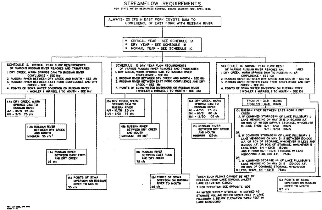
69 APPENDIX VIII MINIMUM STREAMFLOW REQUIREMENTS IN THE RUSSIAN RIVER Source: State Water Resources Control Board Decision 1610, April 1986
70
71 APPENDIX IX SURVEY FORM SENT TO POTENTIALLY AFFECTED PROPERTY OWNERS
72 NAME Return to: Sonoma County Planning Department ADDRESS Melanie Perry 575 Administration Drive, Room 105A AP #: Santa Rosa CA Re: Opening of the Mouth of the Russian River 1. Is your property affected by flooding when the River mouth is closed? Yes No 2. What type of property is affected? Residential Agricultural Commercial 3. RESIDENTIAL a Is your yard flooded? Yes No b. What is the use of this land and percentage of parcel affected? c. Do you have a boat dock that would be damaged by flooding? Yes No d. Are any accessory buildings flooded? Yes No If so, what is the accessory building square footage affected? e. Would your residence flood if the River mouth is closed? Yes No Do you know at what height of the River (measured at the Jenner gauge) that your residence floods? 8 feet 9 feet 10 feet Other f. What is the use of the area of your residence that would be flooded? Foundation / sq. ft. Basement / sq. ft. Living Area / sq. ft. g. What is the use of the living area affected and square footage? 4. AGRICULTURAL a How much land in terms of acreage is affected by flooding when the mouth is closed? b. What is the use of the land affected?
73 Page 2 Russian River Study Questionnaire c. At what height of the river is your agricultural land substantially affected? (measured at the Jenner gauge.) 7½ feet 8 feet 9 feet 10 feet Other d. How does the flooding affect your agricultural operation? 5. COMMERCIAL a What is the commercial use of your property? b. What is the use of any outdoor area affected? Parking Lot Landscaping Other, describe: c. At what River height (measured at the Jenner gauge), is your property substantially affected by flooding? 8 feet 9 feet 10 feet Other d. What is the use of the structure that would be affected? Foundation / sq. ft. Basement / sq. ft Storage / sq. ft. Office/sq. ft. Pubic Area / sq. ft. Other / sq. ft. e. Describe how your commercial operation would be affected if the River mouth remained closed and flooding occurred? 6. Other Comments:
RUSSIAN RIVER ESTUARY STUDY
 RUSSIAN RIVER ESTUARY STUDY 1992-1993 Russian River Estuary Study 1992-1993 prepared for Department of Planning Sonoma County Melanie Heckel, Project Manager and California State Coastal Conservancy Julia
Coastal Sediment Transport Modeling Ocean Beach & San Francisco Bight, CA
 1 Coastal Sediment Transport Modeling Ocean Beach & San Francisco Bight, CA Honghai Li and Lihwa Lin Engineering Research and Development Center U.S. Army Corps of Engineers Frank Wu, Lisa Andes, and James
APPENDIX C. Fluvial and Tidal Hydraulics Report
 APPENDIX C Fluvial and Tidal Hydraulics Report BUENA VISTA LAGOON ENHANCEMENT PROJECT FLUVIAL AND TIDAL HYDRAULICS ANALYSES Prepared for: SANDAG 401 B Street, Suite 800 San Diego, California 92101 Contact:
LOCAL COASTAL PROGRAM UPDATE
 LOCAL COASTAL PROGRAM UPDATE Agenda Meeting #1 General Information (1 1:45 pm) Introductions and Background Grants involved What is a Local Coastal Program? What is required? LCP Update tasks and schedule
CLAM PASS RESTORATION AND MANAGEMENT PLAN BATHYMETRIC MONITORING REPORT NO. 7 Including Interior Bay Dredge Cuts and Tidal Data
 CLAM PASS RESTORATION AND MANAGEMENT PLAN BATHYMETRIC MONITORING REPORT NO. 7 Including Interior Bay Dredge Cuts and Tidal Data Submitted to: Florida Department of Environmental Protection DEP File No.
SUPPLEMENTAL DOCUMENT SEA LEVEL RISE SCENARIO SELECTION AND DESIGN TIDE CALCULATION
 SUPPLEMENTAL DOCUMENT SEA LEVEL RISE SCENARIO SELECTION AND DESIGN TIDE CALCULATION FOR THE GUIDANCE FOR INCORPORATING SEA LEVEL RISE INTO CAPITAL PLANNING IN SAN FRANCISCO: ASSESSING VULNERABILITY AND
Inlet Management Study for Pass-A-Grille and Bunces Pass, Pinellas County, Florida
 Inlet Management Study for Pass-A-Grille and Bunces Pass, Pinellas County, Florida Final Report Submitted By Ping Wang, Ph.D., Jun Cheng Ph.D., Zachary Westfall, and Mathieu Vallee Coastal Research Laboratory
WATERWAYS AND HARBORS DIVISION Proceedings of the American Society of Civil Engineers. EQUILIBRIUM FLOW AREAS OF INLETS ON SANDY COASTS a
 6405 February, 1969 WWl J oumal of the WATERWAYS AND HARBORS DIVISION Proceedings of the American Society of Civil Engineers EQUILIBRIUM FLOW AREAS OF INLETS ON SANDY COASTS a By Morrough P. O'Brien,!
Beach Renourishment in Jacksonville
 Beach Renourishment in Jacksonville Kevin Bodge, PhD, P.E. - Olsen Associates, Inc. 1978 Oct 2004 2000 2016 2011 Oct 2016 Coastal Duval County, FL Nassau Sound Blount Island Ft. George Inlet St. Johns
APPENDIX D-2. Sea Level Rise Technical Memo
 APPENDIX D-2 Sea Level Rise Technical Memo 2185 N. California Blvd., Suite 500 Walnut Creek, CA 94596 (925) 944-5411 Fax: (925) 944-4732 www.moffattnichol.com DRAFT MEMORANDUM To: From: Neil Nichols,
Impact of Dredging the Lower Narrow River on Circulation and Flushing
 Impact of Dredging the Lower Narrow River on Circulation and Flushing Craig Swanson Ph.D. Swanson Environmental Alex Shaw Ocean Engineering, URI Prof. Malcolm L. Spaulding Ocean Engineering, URI 29 January
Area of existing house. Gross Flr. area excluding parking. (+1,657 basement) Gross Flr. area inc. covered parking & accessory bldg.
 Gross Flr. area inc. covered parking & accessory bldg.") ABBREVIATIONS MATERIALS Area of existing house AREA CALCULATIONS Gross Flr. area excluding parking Gross Flr. area inc. covered parking & accessory bldg.,773 sf. 6,086sf. (+,657 basement) 6,776sf. (+,657
ABBREVIATIONS MATERIALS Area of existing house AREA CALCULATIONS Gross Flr. area excluding parking Gross Flr. area inc. covered parking & accessory bldg.,773 sf. 6,086sf. (+,657 basement) 6,776sf. (+,657
CROSS-SHORE SEDIMENT PROCESSES
 The University of the West Indies Organization of American States PROFESSIONAL DEVELOPMENT PROGRAMME: COASTAL INFRASTRUCTURE DESIGN, CONSTRUCTION AND MAINTENANCE A COURSE IN COASTAL DEFENSE SYSTEMS I CHAPTER
COUPLED MANAGEMENT STRATEGY LAKE CATHIE ESTUARY & COAST
 Lake Cathie Progress Association Inc. ABN 28 251 433 854 P.O. Box 247 Lake Cathie NSW 2445 PHONE/FAX: 02 6584 8211 EMAIL: r3packag@bigpond.com 20 th October 2009 Port Macquarie Hastings Council PO Box
SAN DIEGUITO WETLANDS RESTORATION PROJECT 08 JANUARY 2018 BEACH PROFILES CITY OF DEL MAR, CALIFORNIA. Data Report
 SAN DIEGUITO WETLANDS RESTORATION PROJECT 08 JANUARY 2018 BEACH PROFILES CITY OF DEL MAR, CALIFORNIA Data Report Prepared by Coastal Environments, Inc. 2166 Avenida de la Playa, Suite E La Jolla, CA 92037
APPENDIX J HYDROLOGY AND WATER QUALITY
 APPENDIX J HYDROLOGY AND WATER QUALITY J-1 Technical Report on Airport Drainage, Northern Sector Airport and Ordinance Creek Watershed / Preliminary Creek Constructed Natural Channel Culvert J-2 Preliminary
New Jersey Coastal Zone Overview. The New Jersey Beach Profile Network (NJBPN) 3 Dimensional Assessments. Quantifying Shoreline Migration
 3 Dimensional Assessments. Quantifying Shoreline Migration") New Jersey Coastal Zone Overview The New Jersey Beach Profile Network (NJBPN) Objectives Profile Locations Data Collection Analyzing NJBPN Data Examples 3 Dimensional Assessments Methodology Examples Quantifying
New Jersey Coastal Zone Overview The New Jersey Beach Profile Network (NJBPN) Objectives Profile Locations Data Collection Analyzing NJBPN Data Examples 3 Dimensional Assessments Methodology Examples Quantifying
USING BIOLOGICALLY IMPORTANT PHYSICAL CHARACTERISTICS OF ESTUARIES TO CLASSIFY AUSTRALIAN AND NEW ZEALAND ESTUARIES
 USING BIOLOGICALLY IMPORTANT PHYSICAL CHARACTERISTICS OF ESTUARIES TO CLASSIFY AUSTRALIAN AND NEW ZEALAND ESTUARIES Michael Whelan, Southern Cross University, Australia. Peter Saenger, Southern Cross University,
CHAPTER 281 INFLUENCE OF NEARSHORE HARDBOTTOM ON REGIONAL SEDIMENT TRANSPORT
 CHAPTER 281 INFLUENCE OF NEARSHORE HARDBOTTOM ON REGIONAL SEDIMENT TRANSPORT Paul C.-P. Lin, Ph.D., P.E. 1 and R. Harvey Sasso, P.E. 2 ABSTRACT The influence of nearshore hardbottom on longshore and cross-shore
HURRICANE SANDY LIMITED REEVALUATION REPORT UNION BEACH, NEW JERSEY DRAFT ENGINEERING APPENDIX SUB APPENDIX D SBEACH MODELING
 HURRICANE SANDY LIMITED REEVALUATION REPORT UNION BEACH, NEW JERSEY DRAFT ENGINEERING APPENDIX SUB APPENDIX D SBEACH MODELING Rev. 18 Feb 2015 1 SBEACH Modeling 1.0 Introduction Following the methodology
PROFILE OF SACRAMENTO RIVER, FREEPORT TO VERONA, CALIFORNIA,
 PROFILE OF SACRAMENTO RIVER, FREEPORT TO VERONA, CALIFORNIA, FLOOD OF FEBRUARY 1986 By J.C. Blodgett and J.B. Lucas U.S. GEOLOGICAL SURVEY Open-File Report 88-82 CO CM I m r-h CM Sacramento, California
Redondo Beach Boat Launch Ramp Facility
 Redondo Beach Boat Launch Ramp Facility Feasibility Report for the California Department of Boating and Waterways 2015 Grant Cycle For the City of Redondo Beach Submitted by March 13, 2014 Table of Contents
The Cumulative Impacts of Shoreline Armoring on Forage Fish Spawning Habitat in San Juan County, Washington
 Western Washington University Western CEDAR Salish Sea Ecosystem Conference 2014 Salish Sea Ecosystem Conference (Seattle, Wash.) May 1st, 1:30 PM - 3:00 PM The Cumulative Impacts of Shoreline Armoring
Eelgrass Survey Reporting Form 2222 Channel Road Newport Beach, CA Eelgrass (Zostera marina) Survey
 Survey") Eelgrass Survey Reporting Form 2222 Channel Road Newport Beach, CA 92660 Eelgrass (Zostera marina) Survey Survey Date: July 19th, 2013 Report Date: July 26 th, 2013 Prepared by: Coastal Resources Management,
Eelgrass Survey Reporting Form 2222 Channel Road Newport Beach, CA 92660 Eelgrass (Zostera marina) Survey Survey Date: July 19th, 2013 Report Date: July 26 th, 2013 Prepared by: Coastal Resources Management,
North Half Moon Bay Shoreline Improvement Project, Pillar Point Harbor, CA Coastal Engineering Appendix
 Engineer Research & Development Center / San Francisco District U. S. Army Corps of Engineers North Half Moon Bay Shoreline Improvement Project, Pillar Point Harbor, CA Coastal Engineering Appendix Photograph
Corte Madera Creek Flood Control Channel
 Corte Madera Creek Flood Control Channel Prepared for Friends of Corte Madera Creek Watershed Marin County Flood Control and Water Conservation District U.S. Army Corps of Engineers Prepared by Michael
Future Condi,ons coastal hazard modeling and mapping
 Future Condi,ons coastal hazard modeling and mapping Presented by Bob Ba:alio, PE Environmental Science Associates, Inc. (ESA) On behalf of the physical processes team (USGS, TerraCosta- Scripps, ESA)
Coastal Environments Oceanographic and Engineering Expertise
 Coastal Environments Oceanographic and Engineering Expertise Coastal Environments La Jolla, CA www.coastalenvironments.com 14 May 2004 CE Ref. No. 04-05 EcoSystems Management Associates, Inc. Carlsbad,
Figure 4, Photo mosaic taken on February 14 about an hour before sunset near low tide.
 The Impact on Great South Bay of the Breach at Old Inlet Charles N. Flagg and Roger Flood School of Marine and Atmospheric Sciences, Stony Brook University Since the last report was issued on January 31
U.S. Army Engineer Institute for Water Resources
 Sea Level Change Curve Calculator (2014.88) (DRAFT) U.S. Army Engineer Institute for Water Resources Table of Contents 1. INTRODUCTION... 2 1.1 BACKGROUND... 2 1.1.1 INFORMATION QUALITY ACT... 2 1.2 OVERVIEW...
SACO RIVER AND CAMP ELLIS BEACH SACO, MAINE SECTION 111 SHORE DAMAGE MITIGATION PROJECT APPENDIX F ECONOMIC ASSESSMENT
 SACO RIVER AND CAMP ELLIS BEACH SACO, MAINE SECTION 111 SHORE DAMAGE MITIGATION PROJECT APPENDIX F ECONOMIC ASSESSMENT Department of the Army New England District, Corps of Engineers 696 Virginia Road
Mouth of the Columbia River Jetties Three-Phase Construction Plan
 Mouth of the Columbia River Jetties Three-Phase Construction Plan Project Overview October 9, 2012 US Army Corps of Engineers MCR Jetties Major Rehabilitation Sand Island pile dikes 1930-1935 Columbia
The Blue Heron Slough Conservation Bank
 1 The Blue Heron Slough Conservation Bank CONSERVATION BANKING July 19-23, 2010 CASE STUDY SERIES The Blue Heron Slough Conservation Bank (Washington) I. OVERVIEW & BACKGROUND: Location: Snohomish River
SHORE PROTECTION AND HABITAT CREATION AT SHAMROCK ISLAND, TEXAS ABSTRACT
 SHORE PROTECTION AND HABITAT CREATION AT SHAMROCK ISLAND, TEXAS M. Cameron Perry, P.E., and Daniel J. Heilman, P.E. Coastal Engineer Shiner Moseley & Associates., Inc. 555 N. Carancahua Corpus Christi,
Open Pacific Coast Study. California Coastal Analysis and Mapping Project
 Open Pacific Coast Study California Coastal Analysis and Mapping Project September 2012 California Open Coast Counties California Coastal Analysis and Mapping Project This publication is an initiative
Plan B Dam Breach Assessment
 Plan B Dam Breach Assessment Introduction In support of the Local Sponsor permit applications to the states of Minnesota and North Dakota, a dam breach analysis for the Plan B alignment of the Fargo-Moorhead
Cordova Harbor Page 2 of 9
 Cordova Harbor Cordova Harbor Page 2 of 9 Condition of Improvements 30 December 2017 Cordova Harbor, Alaska (CWIS No. 087136, 087186, 087711) Authorization Rivers and Harbors Act, 30 August 1935 (R & H
APPENDIX D W-19 FLUVIAL AND TIDAL HYDRAULIC, SEDIMENTATION, WATER QUALITY AND SEA LEVEL RISE MODELING STUDIES
 APPENDIX D W-19 FLUVIAL AND TIDAL HYDRAULIC, SEDIMENTATION, WATER QUALITY AND SEA LEVEL RISE MODELING STUDIES Final EIR November 2018 Appendices Executive Summary Background: The San Dieguito Lagoon W19
Beach Nourishment Impact on Beach Safety and Surfing in the North Reach of Brevard County, Florida
 Beach Nourishment Impact on Beach Safety and Surfing in the North Reach of Brevard County, Florida Prepared by John Hearin, Ph.D. Coastal Engineering Vice Chairman Cocoa Beach Chapter Port Canaveral Patrick
Beach Profiles. Topics. Module 9b Beach Profiles and Crossshore Sediment Transport 3/23/2016. CE A676 Coastal Engineering
 Beach Profiles AND CROSS-SHORE TRANSPORT Orson P. Smith, PE, Ph.D., Professor Emeritus Topics Features of beach and nearshore profiles Equilibrium profiles Cross-shore transport References Text (Sorensen)
Hydrologic Feasibility of Storm Surge Barriers
 Hydrologic Feasibility of Storm Surge Barriers Malcolm J. Bowman, School of Marine and Atmospheric Sciences State University of New York, Stony Brook, NY. Presented at Against the Deluge: Storm Surge Barriers
Dry Creek Project. The Dry Creek Habitat Enhancement Project provides a. Slowing velocity, creating refuge are key to habitat project
 Dry Creek Habitat Enhancement Bulletin The Dry Creek Habitat Enhancement Project provides a unique opportunity for the Sonoma County Water Agency (Water Agency) and landowners to protect endangered fish
OFFICE OF STRUCTURES MANUAL FOR HYDROLOGIC AND HYDRAULIC DESIGN CHAPTER 11 APPENDIX B TIDEROUT 2 USERS MANUAL
 OFFICE OF STRUCTURES MANUAL FOR HYDROLOGIC AND HYDRAULIC DESIGN CHAPTER 11 APPENDIX B TIDEROUT 2 USERS MANUAL APRIL 2011 APRIL 2011 Page 1 Preface TIDEROUT 2, Build 1.22 dated June 29, 2006 is the current
VENICE LOCAL COASTAL PROGRAM UPDATE: COASTAL HAZARDS WELCOME
 VENICE LOCAL COASTAL PROGRAM UPDATE: COASTAL HAZARDS WELCOME 1 Introducing the Team Hosted by the Department of City Planning and grant funded in part by the California Coastal Commission 2 Workshop Purpose
Technical Report Culvert A Hydraulic Analysis
 DATE: November 3, 2011 Technical Report Culvert A Hydraulic Analysis TO: FROM: RE: Jim Reiser, P.E. Project Manager Parsons Brinckerhoff, Inc. Kurt Killian, P.E., CFM Parsons Brinckerhoff, Inc. Design
MEAN LOW TIDE (MLT) to MEAN LOWER LOW WATER (MLLW)
 to MEAN LOWER LOW WATER (MLLW)") MEAN LOW TIDE (MLT) to MEAN LOWER LOW WATER (MLLW) WEDA GULF COAST CHAPTER ANNUAL CONFERENCE Christopher Frabotta Deputy Chief, Operations Division Galveston District Southwestern Division November 16,
MEAN LOW TIDE (MLT) to MEAN LOWER LOW WATER (MLLW) WEDA GULF COAST CHAPTER ANNUAL CONFERENCE Christopher Frabotta Deputy Chief, Operations Division Galveston District Southwestern Division November 16,
The Storm Surge Hazard 2018 TS-8 Tropical Meteorology 2
 The Storm Surge Hazard 2018 TS-8 Tropical Meteorology 2 Daniel Noah National Weather Service Tampa Bay daniel.noah@noaa.gov Tropical Cyclone Storm Surge Is a large dome of water, often 50 to 100 miles
Response of a Newly Created Marsh-Wetland Affected by Tidal Forcing, Upland Discharge, and Groundwater Interaction
 Response of a Newly Created Marsh-Wetland Affected by Tidal Forcing, Upland Discharge, and Groundwater Interaction Mouth of Columbia River, Cape Disappointment State Park, Washington 12 Hans R. Moritz
APPENDIX H LAKE OKEECHOBEE FLOOD ROUTINES
 1 2 3 APPENDIX H LAKE OKEECHOBEE FLOOD ROUTINES 1 2 3 4 5 6 7 8 9 10 11 12 13 14 15 16 17 18 19 20 21 22 23 24 25 26 27 28 29 30 31 32 33 34 35 36 37 38 39 40 41 42 43 44 45 LAKE OKEECHOBEE FLOOD ROUTINGS
EVALUATION OF BEACH EROSION UP-DRIFT OF TIDAL INLETS IN SOUTHWEST AND CENTRAL FLORIDA, USA. Mohamed A. Dabees 1 and Brett D.
 EVALUATION OF BEACH EROSION UP-DRIFT OF TIDAL INLETS IN SOUTHWEST AND CENTRAL FLORIDA, USA Mohamed A. Dabees 1 and Brett D. Moore 1 The paper discusses the analysis of up-drift beach erosion near selected
MOREHEAD CITY HARBOR, NC. Dredged Material Management Plan (DMMP)
") MOREHEAD CITY HARBOR, NC Dredged Material Management Plan (DMMP) Public Meeting/Info Session 15 January 2014 US Army Corps of Engineers Morehead City Harbor DMMP Presentation Topics Morehead City Harbor
MOREHEAD CITY HARBOR, NC Dredged Material Management Plan (DMMP) Public Meeting/Info Session 15 January 2014 US Army Corps of Engineers Morehead City Harbor DMMP Presentation Topics Morehead City Harbor
INTRODUCTION TO COASTAL ENGINEERING
 The University of the West Indies Organization of American States PROFESSIONAL DEVELOPMENT PROGRAMME: COASTAL INFRASTRUCTURE DESIGN, CONSTRUCTION AND MAINTENANCE A COURSE IN COASTAL DEFENSE SYSTEMS I CHAPTER
FINAL ENVIRONMENTAL IMPACT STATEMENT ON BROWARD COUNTY SHORE PROTECTION PROJECT SEGMENTS II AND III BROWARD COUNTY, FLORIDA
 FINAL ENVIRONMENTAL IMPACT STATEMENT ON BROWARD COUNTY SHORE PROTECTION PROJECT SEGMENTS II AND III BROWARD COUNTY, FLORIDA 1. PROJECT PURPOSE AND NEED 1.1. PROJECT AUTHORITY. 1.1.1. INITIAL AUTHORIZATION.
San Lorenzo Valley Water District, Watershed Management Plan, Final Version Part I: Existing Conditions Report
 LIST OF FIGURES Figure 1-1. Map of the San Lorenzo River watershed Figure 2-1. The Santa Cruz Mountains Bioregion Figure 2-2. Protected areas within the San Lorenzo River watershed Figure 2-3. Primary
Nearshore Dredged Material Placement Pilot Study at Noyo Harbor, CA
 1 Nearshore Dredged Material Placement Pilot Study at Noyo Harbor, CA Noyo Cove N 2011 National Conference on Beach Preservation Technology 9-11, February 2011 Lihwa Lin, Honghai Li, Mitchell Brown US
Dune Monitoring Data Update Summary: 2013
 Dune Monitoring Data Update Summary: 13 Shoreline Studies Program Virginia Institute of Marine Science College of William & Mary Gloucester Point, Virginia September 13 Dune Monitoring Data Update Summary:
Developing Back Bay. Pre-Handout. Scope and Background
 Developing Back Bay Pre-Handout Scope and Background This is your third project and substantially different from the first two. It is actually a large scale planning project and as such, it is open ended.
Feasibility Study for Restoration of Titlow Lagoon Fish Passage. South Puget Sound Salmon Enhancement Group
 Feasibility Study for Restoration of Titlow Lagoon Fish Passage South Puget Sound Salmon Enhancement Group January 2010 Feasibility Study for Restoration of Titlow Lagoon Fish Passage Prepared for South
Modeling 3D circulation in the Choctawhatchee Bay and River System
 Modeling 3D circulation in the Choctawhatchee Bay and River System Rosemary Cyriac 1, Casey Dietrich 1, Arash Fathi 2, Clint Dawson 2, Kendra Dresback 3, Cheryl Ann Blain 4, Matthew Bilskie 5, Scott Hagen
CLAM PASS ANNUAL RESTORATION & MANAGEMENT PLAN TIDAL ANALYSIS ELEMENT REPORT NO. 13
 CLAM PASS ANNUAL RESTORATION & MANAGEMENT PLAN TIDAL ANALYSIS ELEMENT REPORT NO. 13 Submitted to: Pelican Bay Services Division Prepared by: Humiston & Moore Engineers H&M File No. 13-078 November 2012
POLITICS A MONUMENTAL TASK FOR STREAM RESTORATION: AN EXAMPLE FROM TRAPPER CREEK OREGON
 POLITICS A MONUMENTAL TASK FOR STREAM RESTORATION: AN EXAMPLE FROM TRAPPER CREEK OREGON Bradley S. Houslet and Louis Wasniewski Deschutes National Forest TRAPPER CREEK, OR ODELL LAKE PROJECT OBJECTIVES
Coastal Hazards Study
 Coastal Hazards Study 2212 Beach Boulevard, Pacifica Prepared for: EXECUTIVE SUMMARY City of Pacifica 170 Santa Maria Ave Pacifica, CA 94044 Prepared by: moffatt & nichol 2185 N. California Blvd. Walnut
Good Mooring to You! Jensen Beach Mooring Field. Kathy Fitzpatrick, P.E. Coastal Engineer, Martin County
 Good Mooring to You! Kathy Fitzpatrick, P.E. Coastal Engineer, Martin County Penny Cutt Regional Manager, Coastal Systems International Mooring Field Advantages Provide a safe and secure anchorage at a
2 nd Steelhead Summit. October 27 & 28, 2016 in San Luis Obispo, CA
 + 2 nd Steelhead Summit October 27 & 28, 2016 in San Luis Obispo, CA 1 + Session Overview Sponsors: California Trout City of San Luis Obispo Sustainable Conservation California Conservation Corps Cachuma
TITLE: The Importance of Model Validation: Two Case Studies. AUTHOR:Julie Thomas. Scripps Institution of Oceanography, La Jolla, CA.
 TITLE: The Importance of Model Validation: Two Case Studies AUTHOR:Julie Thomas Scripps Institution of Oceanography, La Jolla, CA jothomas@ucsd.edu CO-AUTHOR: Corey Olfe Scripps Institution of Oceanography,
US Beach Nourishment Experience:
 Beach Nourishment: Introduction of new sand to the beach by truck or dredge Large beach >1 million cubic yards (100,000 dump truck loads) Funding is a combination of federal, state, local & private Also
Warm-up # 7 A day 5/17 - B day 5/18 UPDATE YOUR TABLE OF CONTENTS
 Warm-up # 7 A day 5/17 - B day 5/18 UPDATE YOUR TABLE OF CONTENTS Question: List all examples of surface water on Earth. Answer: Rivers and streams, lakes and reservoirs, (ponds) wetlands, estuaries and
Restoration of the Nisqually River Delta and increased rearing opportunities for salmonids
 Western Washington University Western CEDAR Salish Sea Ecosystem Conference 2014 Salish Sea Ecosystem Conference (Seattle, Wash.) May 2nd, 8:30 AM - 10:00 AM Restoration of the Nisqually River Delta and
RESILIENCE THROUGH RESTORATION
 RESILIENCE THROUGH RESTORATION RECLAMATION DISTRICT NO. 1601 TWITCHELL ISLAND SAN JOAQUIN RIVER SETBACK LEVEE PROJECT TWITCHELL ISLAND BASICS Nearly 12 miles of levee Storm drainage facilities Protects
Public Notice U.S. Army Corps In Reply to Application Number CENAB-OP-RMS (NATIONAL HARBOR (FORMERLY PORT Baltimore District AMERICA])
![Public Notice U.S. Army Corps In Reply to Application Number CENAB-OP-RMS (NATIONAL HARBOR (FORMERLY PORT Baltimore District AMERICA])](/thumbs/89/100795623.jpg "Public Notice U.S. Army Corps In Reply to Application Number CENAB-OP-RMS (NATIONAL HARBOR (FORMERLY PORT Baltimore District AMERICA])") Public Notice U.S. Army Corps In Reply to Application Number of Engineers CENAB-OP-RMS (NATIONAL HARBOR (FORMERLY PORT Baltimore District AMERICA]) 88-01361 PN 14-05 Comment Period: January 16, 2014 to
Public Notice U.S. Army Corps In Reply to Application Number of Engineers CENAB-OP-RMS (NATIONAL HARBOR (FORMERLY PORT Baltimore District AMERICA]) 88-01361 PN 14-05 Comment Period: January 16, 2014 to
Applications of ELCIRC at LNEC
 stratification in the Guadiana estuary tidal propagation in the Óbidos lagoon Lígia Pinto Anabela Oliveira André B. Fortunato 2 O utline Stratification in the Guadiana estuary The Guadiana estuary Objectives
TABLE OF CONTENTS CHAPTER TITLE PAGE LIST OF TABLES LIST OF FIGURES LIST OF ABBREVIATIONS LIST OF SYMBOLS LIST OF APPENDICES
 vii TABLE OF CONTENTS CHAPTER TITLE PAGE AUTHOR S DECLARATION DEDICATION ACKNOWLEDGEMENTS ABSTRACT ABSTRAK TABLE OF CONTENTS LIST OF TABLES LIST OF FIGURES LIST OF ABBREVIATIONS LIST OF SYMBOLS LIST OF
Texas Water Resources Institute
 Texas Water Resources Institute November/December 1982 Volume 8 No. 6 A Precise Environment By Lou Ellen Ruesink, Editor, Texas Water Resources Aquarium enthusiasts know just how particular fish are about
CMS Modeling of the North Coast of Puerto Rico
 CMS Modeling of the North Coast of Puerto Rico PRESENTED BY: Dr. Kelly Rankin Legault, Ph.D., P.E. 1 Dr. Alfredo Torruella, Ph.D. 2 1 USACE Jacksonville District 2 University of Puerto Rico October 2016
Merkinch Greenspace. Merkinch Local Nature Reserve: Hydrological Assessment
 Merkinch Local Nature Reserve: Hydrological Assessment June 2011 EnviroCentre Craighall Business Park Eagle Street Glasgow G4 9XA t 0141 341 5040 f 0141 341 5045 w www.envirocentre.co.uk e info@envirocentre.co.uk
Chapter 15 SEASONAL CHANGES IN BEACHES OP THE NORTH ATLANTIC COAST OF THE UNITED STATES
 Chapter 15 SEASONAL CHANGES IN BEACHES OP THE NORTH ATLANTIC COAST OF THE UNITED STATES By John M. Darling Hydraulic Engineer, Research Division U. S. Army Coastal Engineering Research Center Corps of
DRAFT. October 17, 2014 File No Mr. Brendhan Zubricki Town Administrator Essex Town Hall 30 Martin Street Essex, MA.
 GZA GeoEnvironmental, Inc. Engineers and Scientists October 17, 2014 File No. 18.0171857.00 Mr. Brendhan Zubricki Town Administrator Essex Town Hall 30 Martin Street Essex, MA. 01929 DRAFT Re: Essex River
A SURVEY OF 1997 COLORADO ANGLERS AND THEIR WILLINGNESS TO PAY INCREASED LICENSE FEES
 Executive Summary of research titled A SURVEY OF 1997 COLORADO ANGLERS AND THEIR WILLINGNESS TO PAY INCREASED LICENSE FEES Conducted by USDA Forest Service Rocky Mountain Research Station Fort Collins,
Survival in an Estuary. Life in a Transition Zone
 Estuary An estuary is a semi-enclosed coastal body of water which has a free connection with the open sea and within which sea water is measurably diluted with fresh water derived from land drainage. (D.
Tidal Observation / Information Of Olero Creek North Water Station And Flowstation Area.
 Tidal Observation / Information Of Olero Creek North Water Station And Flowstation Area. Sylvester Efe OWHOJETA, Nigeria and Emmanuel Olayinka AJAYI, Nigeria ABSTRACT Key words: Tidal information, Reference
SARASOTA BAY ESTUARY PROGRAM OYSTER HABITAT MONITORING RESULTS: YEAR 1. Jay R. Leverone
 SARASOTA BAY ESTUARY PROGRAM OYSTER HABITAT MONITORING RESULTS: YEAR 1 by Jay R. Leverone Mote Marine Laboratory 1600 Ken Thompson Parkway Sarasota, Fl 34236 to Gary Raulerson Sarasota Bay Estuary Program
Effect of Hydrodynamics on Sediment Transport near a Coastal Inlet
 ICHE 2014, Hamburg - Lehfeldt & Kopmann (eds) - 2014 Bundesanstalt für Wasserbau ISBN 978-3-939230-32-8 Effect of Hydrodynamics on Sediment Transport near a Coastal Inlet H. Li, M. Brown, J. Rosati & Z.
Evaluation of June 9, 2014 Federal Emergency Management Agency Flood Insurance Study for Town of Weymouth, Norfolk, Co, MA
 Evaluation of June 9, 2014 Federal Emergency Management Agency Flood Insurance Study for Town of Weymouth, Norfolk, Co, MA Prepared For: Woodard & Curran 95 Cedar Street, Suite 100 Providence, RI 02903
Pre-Season Testing Protocol for the Tri-State Coastal Dungeness crab Commercial Fishery. Revised September 2013
 Pre-Season Testing Protocol for the Tri-State Coastal Dungeness crab Commercial Fishery Revised September 2013 I. Purpose The Washington Department of Fish and Wildlife (WDFW), Oregon Department of Fish
North Shore of Long Island, Feasibility Study
 North Shore of Long Island, Asharoken New York Asharoken, Feasibility Study Asharoken, NY Public Meeting June 30, 2015 US Army Corps of Engineers US Army Corps of Engineers New York BUILDING STRONG BUILDING
FISH PASSAGE IMPROVEMENT in California s Watersheds. Assessments & Recommendations by the Fish Passage Forum
 FISH PASSAGE IMPROVEMENT in California s Watersheds Assessments & Recommendations by the Fish Passage Forum FISH PASSAGE IMPROVEMENT in California s Watersheds The mission of the Fish Passage Forum is
New Jersey Beach Profile Network Atlantic County Profile Site Locations
 215 RICHARD STOCKTON COLLEGE OF NEW JERSEY New Jersey Beach Profile Network Atlantic County Profile Site Locations COASTAL RESEARCH CENTER Figure 128 There are nine NJBPN survey sites on the Atlantic County
Conservation and Restoration Florida s Coastal Marshes: An Overview of MESS. Jeff Beal, Kent Smith, Erin McDevitt, Maria Merrill
 Conservation and Restoration Florida s Coastal Marshes: An Overview of MESS Jeff Beal, Kent Smith, Erin McDevitt, Maria Merrill FWC s MESS: -Marine/Estuarine Subsection -within Aquatic Habitat Conservation
San Diego Coastal Ocean Observing System
 California Clean Beaches Initiative San Diego Coastal Ocean Observing System WWW.SDCOOS.ORG Presentation to Imperial Beach City Council August 3, 2005 Eric J. Terrill, Ph.D. Scripps Institution of Oceanography
PHYSICAL MONITORING WILMINGTON HARBOR NAVIGATION PROJECT REPORT 1: August 2000 June 2003
 PHYSICAL MONITORING WILMINGTON HARBOR NAVIGATION PROJECT REPORT 1: August 2000 June 2003 AUGUST 2004 For questions or comment, contact Project Manager, Ms. Sharon Haggett, 910-251-4441 EXECUTIVE SUMMARY
Coastal Engineering Technical Note
 Coastal Engineering Technical Note BAFFLED BREAKWATER FOR LIMITED FETCH SITES CETN III-45.(12/91) PURPOSE: To describe the Spud Point Marina breakwater, an innovative baffledtype breakwater designed to
Assateague Island National Seashore North End Restoration Project Timeline
 Assateague Island National Seashore North End Restoration Project Timeline Date Event Some information provided in the Project Introduction document. Detailed events are available in a timeline compiled
CCoWS. Central Coast Watershed Studies. Summary of Precipitation and Streamflow for Potrero and San Clemente Creeks in 2010
 Central Coast Watershed Studies CCoWS Summary of Precipitation and Streamflow for Potrero and San Clemente Creeks in Water-Year 2010 Santa Lucia Preserve Monterey County, California Publication No. WI-2011-01
Skagit River Historical Flood Elevations and Peak Flow Estimates
 Skagit River Historical Flood Elevations and Peak Flow Estimates to be presented at Skagit River GI H&H Technical Workshop Wednesday, June 17, 2009 Background Corps of Engineers began a General Investigation
Sea Level Rise and Coastal Flooding Why Waves Matter!
 Sea Level Rise and Coastal Flooding Why Waves Matter! Jason D. Burtner Massachusetts Office of Coastal Zone Management South Shore Regional Coordinator Sea Level Rise and Coastal Storm Damage and Flooding
November 13, Planning and Land Development Regulation Commission (PLDRC)
") 1 of 29 GROWTH AND RESOURCE MANAGEMENT DEPARTMENT PLANNING AND DEVELOPMENT SERVICES DIVISION CURRENT PLANNING ACTIVITY 123 W. Indiana Avenue, DeLand, FL 32720 (386) 943-7059 PUBLIC HEARING: CASE NO: SUBJECT:
1 of 29 GROWTH AND RESOURCE MANAGEMENT DEPARTMENT PLANNING AND DEVELOPMENT SERVICES DIVISION CURRENT PLANNING ACTIVITY 123 W. Indiana Avenue, DeLand, FL 32720 (386) 943-7059 PUBLIC HEARING: CASE NO: SUBJECT:
Sediment Management Plan Rehoboth Bay
 Sediment Management Plan Rehoboth Bay STAC Meeting November 16, 2007 Goals of the Study Improve planning for future dredging needs Reduce the dependency on dredging Study Tasks Environmental data Historical
1-44. SITKA HARBOR, ALASKA (Western Channel, Crescent Bay Basin, Channel Rock Breakwaters) (CWIS NOS , 16840, 10322, 55030, 13787)
 (CWIS NOS , 16840, 10322, 55030, 13787)") SITKA 1-44 SITKA HARBOR, ALASKA (Western Channel, Crescent Bay Basin, Channel Rock Breakwaters) (CWIS NOS. 72845, 16840, 10322, 55030, 13787) Condition of Improvement 30 September 2011 AUTHORIZATION:
SITKA 1-44 SITKA HARBOR, ALASKA (Western Channel, Crescent Bay Basin, Channel Rock Breakwaters) (CWIS NOS. 72845, 16840, 10322, 55030, 13787) Condition of Improvement 30 September 2011 AUTHORIZATION:
Available online at ScienceDirect. Procedia Engineering 116 (2015 )
") Available online at www.sciencedirect.com ScienceDirect Procedia Engineering 116 (2015 ) 320 325 8th International Conference on Asian and Pacific Coasts (APAC 2015) Department of Ocean Engineering, IIT
Available online at www.sciencedirect.com ScienceDirect Procedia Engineering 116 (2015 ) 320 325 8th International Conference on Asian and Pacific Coasts (APAC 2015) Department of Ocean Engineering, IIT
Chapter 4 EM THE COASTAL ENGINEERING MANUAL (Part I) 1 August 2008 (Change 2) Table of Contents. Page. I-4-1. Background...
 1 August 2008 (Change 2) Table of Contents. Page. I-4-1. Background...") Chapter 4 EM 1110-2-1100 THE COASTAL ENGINEERING MANUAL (Part I) 1 August 2008 (Change 2) Table of Contents I-4-1. Background... Page I-4-1 a. Shore Protection Planning and Design, TR 4... I-4-1 b. Shore
Chapter 4 EM 1110-2-1100 THE COASTAL ENGINEERING MANUAL (Part I) 1 August 2008 (Change 2) Table of Contents I-4-1. Background... Page I-4-1 a. Shore Protection Planning and Design, TR 4... I-4-1 b. Shore