US Sugar Land Purchase, River of Grass Project, SugarHill Sector Plan, Amendment 1
|
|
|
- Sarah Howard
- 5 years ago
- Views:
Transcription
1 US Sugar Land Purchase, River of Grass Project, SugarHill Sector Plan, Amendment 1 Rivers Coalition September 24, 2014 Upper Chain of Lakes Lake Kissimmee Kissimmee River Caloosahatchee Estuary Lake Okeechobee Indian River Lagoon St. Lucie Estuary Everglades Mark Perry, Executive Director Florida Oceanographic Society Biscayne Bay Florida Bay Coral Reefs


2 Upper Chain of Lakes flow south into Lake Kissimmee Lake Kissimmee flows south into the Kissimmee River 105-mile Oxbow River with 2-mile-wide floodplain Water takes 6-8 Months to reach Lake Okeechobee Lake Okeechobee flows south through River of Grass, Everglades - 60-mile wide shallow (1 ft deep) river flowing at 1 mile in 4 days. River of Grass Water takes 16 Months to reach Florida Bay
3 Upper Chain of Lakes Lake Kissimmee Indian River Lagoon Lake Okeechobee St. Lucie Estuary Caloosahatchee Estuary Biscayne Bay Florida Bay Coral Reefs 1.7 Billion Gallons per Day of freshwater is wasted to the Atlantic Ocean and Gulf of Mexico! ($5.9 million/day)

4 Everglades & Surrounding Areas 1994 Everglades Forever Act Projects $ 1.2 Billion
 A series of environmental and other improvements over 30+ years with an estimated cost of")
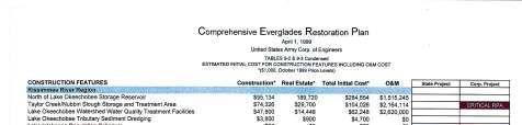
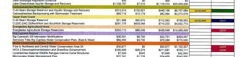
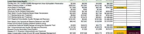
5 Rescuing an Endangered Ecosystem: The Plan to Restore America s Everglades On December 11, 2000, the President signed the Water Resources Development Act (WRDA) of 2000, approving: Comprehensive Everglades Restoration Plan The Central and Southern Florida Project Comprehensive Review Study (The Restudy) A series of environmental and other improvements over 30+ years with an estimated cost of $7.8 billion (Now $10-14 billion )
 7. Tamiami Trail - Next Steps Bridging (DOI, USACOE, Florida) 1st Generation CERP (Authorized WRDA 2007 Under Construction) 1.")
6 Everglades Restoration Projects Non-CERP (Comprehensive Everglades Restoration Plan) 1. Kissimmee River 2. C-111 South Dade 3. C-51/STA-1E 4. Modified Water Deliveries 5. Herbert Hoover Dike Rehab 6. State Restoration Strategies Water Quality (Florida) 7. Tamiami Trail - Next Steps Bridging (DOI, USACOE, Florida) 1st Generation CERP (Authorized WRDA 2007 Under Construction) 1. Site 1 Impoundment 2. IRL-South (C-44 Project, C-23/C-24/C-25 Project) 3. Picayune Strand Current Everglades Restoration Projects 2nd Generation CERP (Authorized -WRRDA 2014) 1. C-43 Reservoir 2. Broward County WPA 3. C-111 Spreader Canal 4. Biscayne Bay Coastal Wetlands 1. Central Everglades Planning Project (CEPP) CERP (Waiting Authorization ) Everglades Agriculture Storage Reservoir WCA 3 Decompartmentalization & Sheetflow Enhancement S-356 Pump Station Modifications L-31 Levee Seepage Management System-Wide Operational Changes Flow to Northwest & Central WCA 3A


7 June 24, ,000 acres US Sugar Corp. farmlands (red color on map)


8 River of Grass Project Planning Stakeholder Meetings - 9 different Plans
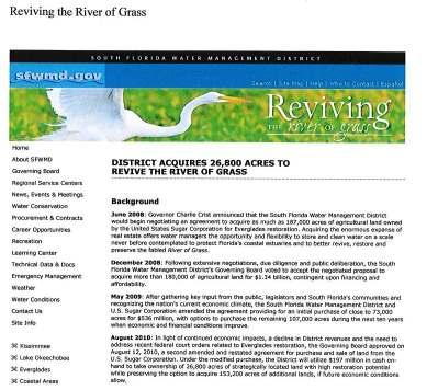
9 US Sugar Land Purchase Purchased October 12, ,900 sugarcane acres-pb County 17,900 citrus acres-hendry County 26,800 acres total 1-Exclusive 3-Year option to purchase 46,800 acres or the entire 153,200 acres at a fixed price-$ 7,400 per acre (Expired: October 2013) 2- Non-exclusive subsequent 2-Year Option to purchase 46,800 acres at Fair Market Value (Expires: October 2015) 3 - Non-exclusive 7-Year Option to purchase remaining acres at Fair Market Value (Expires: October 2020) US Sugar Corp purchase reduced- 73,000 ac -$530 M in April 2009 Then to 26,800 acres - $197 M -October 2010 with10-year Option
")

10 Subsequent 2-year, nonexclusive option 46,800 acres (by October 12, 2015) Sector Plan Lands- 44,000 acres SugarHill Sector Plan - Land Use changes in Hendry County

11 Proposed Land Uses: EC - Employment Center MU - Mixed Use-Urban MS Mixed Use Suburban RE Rural Estates LA Long-Term Agriculture

12 All Option Lands affected by Sector Plan: 32,890 acres
 2- Non-exclusive subsequent 2-Year")
 US Sugar Corp purchase reduced- 73,000 ac -$530 M in April 2009 Then to 26,800 acres - $197 M -October 2010 with10-year")
13 US Sugar Land Purchase Purchased October 12, ,900 sugarcane acres-pb County 17,900 citrus acres-hendry County 26,800 acres total 1-Exclusive 3-Year option to purchase 46,800 acres or the entire 153,200 acres at a fixed price-$ 7,400 per acre (Expired: October 2013) 2- Non-exclusive subsequent 2-Year Option to purchase 46,800 acres at Fair Market Value (Expires: October 2015) 3 - Non-exclusive 7-Year Option to purchase remaining acres at Fair Market Value (Expires: October 2020) US Sugar Corp purchase reduced- 73,000 ac -$530 M in April 2009 Then to 26,800 acres - $197 M -October 2010 with10-year Option
 and C-139 Annex Restoration (9-4-14) Restoration Strategies 2011 Court-Mandated Water Quality Treatment projects - $ 880 Million State of Florida Governor Scott signed HB 7065- May 28,")
14 US Sugar Land Purchase Initial 2010 Purchase 8,900 acres used for exchange (plus $6 M) for STA 1-W Expansion- 4,500 acres Initial 2010 Purchase - 17,900 acres used as Flow Equalization Basin (FEB) and C-139 Annex Restoration (9-4-14) Restoration Strategies 2011 Court-Mandated Water Quality Treatment projects - $ 880 Million State of Florida Governor Scott signed HB May 28, 2013 obligating $32 Million per year for next 10 years!

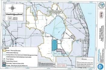
15 Comprehensive Everglades Restoration Plan (CERP) 68 Components 50/50 Cost Share- Federal/State (State buys lands needed)

16 Current Average Annual Discharge Volumes Where the Water Goes Current Maximum Flood Discharge Rates Based on Data Lake Okeechobee ASR Project MGD Proposed CERP Project 1548 cfs S cfs St Lucie Estuary 20 % Caloosahatchee Estuary 44 % 972 K AF per Year S cfs 2.21 M AF per Year S cfs Agriculture 23 % S cfs S cfs C-10 A 900 cfs 508 K AF per Year 442 K AF per Year To the Everglades 13 % 287 K AF per Year


17 Desired Flow Historic, Current & Desired Flows Stop destructive discharges to the Northern Estuaries and Move Water South to Restore the River of Grass- A project needs the capacity for enough annual Storage, Treatment, Conveyance


18 Plan , Reconnect Lake Okeechobee to the Everglades- River of Grass- Move Water South

19 Everglades Agricultural Area (EAA) 700,000 Acres Sugarcane Farmlands ( 50,000 Acres) Pubic Lands (76,000 Acres) (Existing) Stop destructive discharges to the Northern Estuaries and Restore the River of Grass Move Water South- Storage, Treatment, Conveyance

20 S-354 S-351 C-10 A S-352 WCA 3A 1. Becomes THE primary outflow for water from Lake Okeechobee 2. Stops destructive discharge releases from Lake Okeechobee to the Northern Estuaries 3. Replaces the Lake Okeechobee ASR Project of CERP with a project of greater flow & capacity 4. Restores water flows south from the Lake to the Everglades 5. Provides for healthy water levels in Lake Okeechobee 6. Maintains Water Quantity, Quality, Timing and Distribution for Everglades Restoration Stop destructive discharges to the Northern Estuaries and Restore the River of Grass Move Water South- Storage, Treatment, Conveyance
21

22 1 - Learn More about Amendment 1- Vote November 4 th Election Day 2 - Comments on SugarHill Sector Plan due by October 3 rd Send Letter to Governor Scott, copy to Florida Department of Economic Opportunity 3 - Support US Sugar Land Purchase & New River of Grass Project to Stop Lake Discharges to Estuaries and Move Water South to the Everglades.
23 C-24 Canal Indian River Lagoon Atlantic Ocean Florida Oceanographic Coastal Center C-23 Canal St. Lucie River Estuary St. Lucie Inlet Nearshore Reefs Lake Okeechobee C-44 St. Lucie Canal St. Lucie River Estuary and Indian River Lagoon Update September 24, 2014
24

25 Roosevelt Bridge Stress Harm Death Salinity Tolerance for Oysters Death 7 Days For Spat & Juveniles Days For Adults
26


27 Health Warnings posted in the St. Lucie River Estuary 2004, 2005, 2006, 2010, 2012 and 2013
28

29 St. Lucie River Watershed 514,646 Acres Watershed Assessment - February 1999


30 8 Basins 186 Secondary Basins St. Lucie River Estuary Watershed

31 What Does Our Future Look Like? Upper Chain of Lakes Lake Kissimmee Indian River Lagoon Kissimmee River St. Lucie Estuary Lake Okeechobee Caloosahatchee Estuary Everglades Biscayne Bay Florida Bay Coral Reefs
Plan 6 Project. Stop the destructive discharges to the Northern Estuaries and Restore the River of Grass. Upper Chain of Lakes.
 Upper Chain of Lakes Plan 6 Project Lake Kissimmee Kissimmee River Indian River Lagoon Stop the destructive discharges to the Northern Estuaries and Restore the River of Grass Caloosahatchee Estuary Lake
Collaborative. City of Stuart. September 7, Mark Perry, Executive Director Oceanographic Society. Upper Chain of Lakes
 Lake Okeechobee Collaborative Upper Chain of Lakes Lake Kissimmee Indian River Lagoon City of Stuart September 7, 2016 Kissimmee River Caloosahatchee Estuary Lake Okeechobee St. Lucie Estuary Everglades
Indian River Lagoon: Lessons, Challenges and Opportunities
 Indian River Lagoon: Lessons, Challenges and Opportunities Upper Chain of Lakes Lake Kissimmee Kissimmee River Indian River Lagoon Caloosahatchee Estuary Lake Okeechobee St. Lucie Estuary Mark Perry, Executive
Impacts of Freshwater Releases from Lake Okeechobee on Sanibel Island and the Coastal Waters of Lee County
 Photo by Sanibel Captiva Conservation Foundation The freshwater plume extends out of Redfish Pass into the Gulf of Mexico on July 10, 2013. The freshwater plume is clearly visible in the Gulf of Mexico
Kissimmee River Channelization
 Environmental Restoration ti Update Phil Flood, South Florida Water Management District Presentation Overview Kissimmee River Restoration Everglades Stormwater Treatment Areas Comprehensive Everglades
Historical and planned changes in the south Florida ecosystem 1
 FA127 Historical and planned changes in the south Florida ecosystem 1 Alex Score and Charles Jacoby 2 The core of the south Florida ecosystem is a unique watershed, the Kissimmee Okeechobee Everglades
Dear Future Leaders, Your help is greatly appreciated, Mary Ann Conrad Jensen Beach Elementary School Teacher
 TEACHER S EDITION Dear Future Leaders, As you carefully look at the cover of this book, you will realize how fortunate we are to live in such a beautiful place surrounded with rivers, oceans, and lakes.
FLORIDA BAY: AN ECOSYSTEM ON THE BRINK
 E V E R G L A D E S R E S T O R A T I O N F A C T S H E E T FLORIDA BAY: AN ECOSYSTEM ON THE BRINK Background T he Florida Bay estuary is located at the southern edge of the Everglades ecosystem at the
years, as liquid water and vapor, and I know Lake Okeechobee very
 V E R Y EAR LY Y HI H STO R Y HI FRIENDS. MY NAME IS WAYNE DROP. I KNOW, YOU MAY THINK IT S RAIN DROP, BUT NO, IT S WAYNE. I HAPPEN TO BE A WATER DROP WHO LIKES to tell stories, particularly about my favorite
Sea Level Rise in South Florida: Causes, Consequences and Opportunities
 Sea Level Rise in South Florida: Causes, Consequences and Opportunities Dr. Todd A. Crowl Director, Institute of Water & the Environment Director, Southeast Environmental Research Center Co-Founder, Sea
Isaac's rains mean Lake Okeechobee may need lowering
 PLACE AN AD HOME DELIVERY JOBS CARS AUTOS A-Z REAL ESTATE RENTALS MERCHANDISE CLASSIFIED PUBLIC NOTICES Home News Broward Palm Beach Sports Entertainment Travel Lifestyle Business Health Opinion Video
Caloosahatchee River Citizen s Association
 Caloosahatchee River Citizen s Association www.caloosahatchee.org Autumn 2002 Caloosahatchee Regional Park Plan Revised! Public Participation Pays off! Last fall the Lee County Parks & Recreation Department
SOUTH ATLANTIC FISHERY MANAGEMENT COUNCIL
 1 SOUTH ATLANTIC FISHERY MANAGEMENT COUNCIL ONE SOUTHPARK CIRCLE, SUITE 306 CHARLESTON, SOUTH CAROLINA 29407-4699 TEL 843/571-4366 or FAX 843/769-4520 Toll Free 1-866/SAFMC-10 E-mail: safmc@safmc.net Web
Texas Water Resources Institute
 Texas Water Resources Institute November/December 1982 Volume 8 No. 6 A Precise Environment By Lou Ellen Ruesink, Editor, Texas Water Resources Aquarium enthusiasts know just how particular fish are about
Staying in Tune with South Florida s Water Cycle for Scientists, Managers, and Policy Makers in 5 Minutes per Week
 Staying in Tune with South Florida s Water Cycle for Scientists, Managers, and Policy Makers in 5 Minutes per Week Robert Sobczak (Big Cypress Nat l Pres), Todd Hopkins (FWS), Kevin Kotun (Everglades National
Post Hurricane-Irma ecological assessments
 Post Hurricane-Irma ecological assessments Nicholas G. Aumen US Geological Survey On behalf of many scientists April 25, 2018 Caveats and comments The Science Coordination Group sponsored a meeting on
AGENCY/ORGANIZATION OFFICE/DIVISION SECTION/SUBSECTION ACTIONS (Related to Coral Reefs) Natural Resources Planning and Management Division
 Natural Resources Planning and Management Division") AGENCY/ORGANIZATION OFFICE/DIVISION SECTION/SUBSECTION ACTIONS (Related to Coral Reefs) Broward County Environmental Protection and Growth Department Natural Resources Planning and Division Broward County
AGENCY/ORGANIZATION OFFICE/DIVISION SECTION/SUBSECTION ACTIONS (Related to Coral Reefs) Broward County Environmental Protection and Growth Department Natural Resources Planning and Division Broward County
Frequently Asked Questions About Revised Critical Habitat and Economic Analysis for the Endangered Arroyo Toad
 Q Frequently Asked Questions About Revised Critical Habitat and Economic Analysis for the Endangered Arroyo Toad Q. What is the arroyo toad? The arroyo toad (Bufo californicus) is a small, light greenish-grey
HERBERT HOOVER DIKE REHABILITATION PROJECT
 HERBERT HOOVER DIKE REHABILITATION PROJECT Update to the Broward County Water Advisory Board 19 September 2013 Ingrid Bon, PE Project Manager Forward Initial Levees Along Lake Okeechobee Authorized by
National Marine Fisheries Service, Habitat Conservation Division:
 National Marine Fisheries Service, Habitat Conservation Division: Essential Fish Habitat, South East Florida Coral Reef Initiative and Land- Based Sources of Pollution effects on Critical Fisheries Habitats
APPENDIX H LAKE OKEECHOBEE FLOOD ROUTINES
 1 2 3 APPENDIX H LAKE OKEECHOBEE FLOOD ROUTINES 1 2 3 4 5 6 7 8 9 10 11 12 13 14 15 16 17 18 19 20 21 22 23 24 25 26 27 28 29 30 31 32 33 34 35 36 37 38 39 40 41 42 43 44 45 LAKE OKEECHOBEE FLOOD ROUTINGS
East Central Florida Region Matt Culver, Brevard County James Gray, Indian River County Jim Oppenbourn, St. Lucie County Kathy Fitzpatrick, Martin
 James Gray, Indian River County January 14, 2015 East Central Florida Region Matt Culver, Brevard County James Gray, Indian River County Jim Oppenbourn, St. Lucie County Kathy Fitzpatrick, Martin County
Communications Report August 2016
 Communications Report August 2016 Facebook 1,457 total likes, 71 new likes 15 CBBEP Facebook posts about our projects and staff achievements Most successful post reached 26,000 people, 26,000! (PSA to
SALINITY. It's the amount of dissolved salts the water contains.
 AQUATIC ECOSYSTEMS SALINITY The types of organisms in an aquatic ecosystem depend upon the water s Salinity. It's the amount of dissolved salts the water contains. Salinity determines the two main aquatic
NOTICE OF DECISION. DATE: June 13, 2017
 NOTICE OF DECISION DATE: June 13, 2017 TO: FROM: SUBJECT: All Respondents to RFP2017-005 National Estuary Program: 2017-2018 Request for Proposals Category 3: Science and Innovative Projects Frank Sakuma,
APPENDIX A OPERATIONAL STRATEGY PART 1 G-3273 CONSTRAINT RELAXATION/S-356 FIELD TEST AND S-357N REVISED OPERATIONAL STRATEGY (INCREMENT 1.1 AND 1.
 Appendix A Operational Strategy APPENDIX A OPERATIONAL STRATEGY PART 1 G-3273 CONSTRAINT RELAXATION/S-356 FIELD TEST AND S-357N REVISED OPERATIONAL STRATEGY (INCREMENT 1.1 AND 1.2) PART 2 INCREMENT 1 VERSUS
Restoring America s Greatest River: Collaborative Efforts Along The Lower Mississippi
 Restoring America s Greatest River: Collaborative Efforts Along The Lower Mississippi Angeline J. Rodgers, USFWS/LMRCC K. Jack Killgore, USACE/ERDC Paul Hartfield, USFWS CEER July 31, 2014 Photo: Jan Hoover
DELAWARE S VULNERABLE COASTAL AREAS. DELAWARE INLAND BAYS and DELAWARE BAY RECONNAISSANCE STUDY
 DELAWARE S VULNERABLE COASTAL AREAS and the DELAWARE INLAND BAYS and DELAWARE BAY RECONNAISSANCE STUDY Kimberly K. McKenna, PG Delaware Dept. of Natural Resources & Environmental Control Division of Watershed
III. EVERGLADES ENVIRONMENTAL SETTING
 ETHNOGRAPHIC STUDY AND EVALUATION OF TRADITIONAL CULTURAL PROPERTIES OF THE MODERN GLADESMEN CULTURE 21 III. EVERGLADES ENVIRONMENTAL SETTING This chapter provides background for visualizing the Everglades
Restoring the Kootenai: A Tribal Approach to Restoration of a Large River in Idaho
 Restoring the Kootenai: A Tribal Approach to Restoration of a Large River in Idaho Susan Ireland, Kootenai Tribe of Idaho Future of our Salmon Conference Technical Session August 2016 Healthy Floodplains,
The Economic Significance of Florida Bay. Dr. Andrew Stainback GEER April Coral Springs, Florida
 The Economic Significance of Florida Bay Dr. Andrew Stainback GEER April 17-20 Coral Springs, Florida The Economic Significance of Florida Bay o Florida Bay provides numerous benefits that directly impact
APPENDIX A STRUCTURE DESCRIPTIONS AND RATING CURVES. Lake Okeechobee & EAA Vol 3 A-i December 2005 Version 1 Draft 4
 1 1 1 1 1 1 1 1 0 1 0 1 0 APPENDIX A STRUCTURE DESCRIPTIONS AND RATING CURVES Lake Okeechobee & EAA Vol A-i December 00 1 1 1 1 1 1 1 1 0 1 from the drainage area served, under a design head of. feet pool
MDX SR 836/DOLPHIN EXPRESSWAY SOUTHWEST EXTENSION Project Development and Environment PD&E Study Miami-Dade County, Florida
 MDX SR 836/DOLPHIN EXPRESSWAY SOUTHWEST EXTENSION Project Development and Environment PD&E Study Miami-Dade County, Florida Citizens Advisory Committee Meeting March 13, 2018 ETDM NUMBER: 11482 MDX WORK
Lake Okeechobee flood control creates environmental disaster
 Page 1 of 5 Lake Okeechobee flood control creates environmental disaster By Leonora LaPeter Anton and Craig Pittman, Times Staff Writers Saturday, March 19, 2016 2:54pm ON THE CALOOSAHATCHEE RIVER The
Implementing the New Fisheries Protection Provisions under the Fisheries Act
 Implementing the New Fisheries Protection Provisions under the Fisheries Act Discussion Paper Fisheries and Oceans Canada April 2013 Contents 1. Introduction 2. Managing Threats to Canada s Fisheries 3.
MOREHEAD CITY HARBOR, NC. Dredged Material Management Plan (DMMP)
") MOREHEAD CITY HARBOR, NC Dredged Material Management Plan (DMMP) Public Meeting/Info Session 15 January 2014 US Army Corps of Engineers Morehead City Harbor DMMP Presentation Topics Morehead City Harbor
MOREHEAD CITY HARBOR, NC Dredged Material Management Plan (DMMP) Public Meeting/Info Session 15 January 2014 US Army Corps of Engineers Morehead City Harbor DMMP Presentation Topics Morehead City Harbor
Coastal Environments Oceanographic and Engineering Expertise
 Coastal Environments Oceanographic and Engineering Expertise Coastal Environments La Jolla, CA www.coastalenvironments.com 14 May 2004 CE Ref. No. 04-05 EcoSystems Management Associates, Inc. Carlsbad,
Conservation and Restoration Florida s Coastal Marshes: An Overview of MESS. Jeff Beal, Kent Smith, Erin McDevitt, Maria Merrill
 Conservation and Restoration Florida s Coastal Marshes: An Overview of MESS Jeff Beal, Kent Smith, Erin McDevitt, Maria Merrill FWC s MESS: -Marine/Estuarine Subsection -within Aquatic Habitat Conservation
Informational Text Assessment 3
 Local ssessment Item ank Reading Grade 5 Informational Text ssessment 3 Student Name: ate: This assessment is designed to provide information about reading comprehension skills. It contains a reading passage
Florida panther conservation challenges. Darrell Land, Florida Fish and Wildlife Conservation Commission
 Florida panther conservation challenges Darrell Land, Florida Fish and Wildlife Conservation Commission Map from Young and Goldman 1946 depicting Puma distribution in North and Central America Former and
Jacksonville District. Area of Responsibility. Civil Works Real Estate and Mobilization Regulatory District Offices. Puerto Rico U.S.
 Introduction In July 2004, the authors of this history arrived in South Florida, ready to research water management in the region since 1948. For the next several days, we traveled through large cities
STRUCTURE S-65 PURPOSE SPILLWAY OPERATION
 STRUCTURE S-65 This structure is a reinforced concrete, gated spillway with discharge controlled by three cable operated, vertical lift gates, and a reinforced concrete lock structure with two pairs of
Oceans Humans both depend on it and threaten it with their activities
 Oceans Humans both depend on it and threaten it with their activities Oceans Water covers nearly ¾ of the Earth s surface More than 50% of the world s population lives within an hour of the coast Oceans
2013 FEDERAL STORM RESPONSE
 2013 FEDERAL STORM Presented to the Florida Shore & Beach Association Sep 26, 2013 Presented by: COL Alan Dodd Commander, Jacksonville District September 2013 THE COLLABORATION 2 THE PROGRAM 3 THE STORMS
NOTICE OF DECISION. DATE: April 16, 2018
 NOTICE OF DECISION DATE: April 16, 2018 TO: FROM: SUBJECT: All Respondents to RFP2018-002 Indian River Lagoon National Estuary Program: 2018-2019 Request for Proposals Category 2: Science and Innovative
OYSTER REEF RESTORATION; RESTORING ECOLOGICAL FUNCTION
 OYSTER REEF RESTORATION; RESTORING ECOLOGICAL FUNCTION Paul Jensen, David Buzan, and Ka-Leung Lee; Atkins Mark Dumesnil and Julie Sullivan; The Nature Conservancy Presentation Overview The Nature Conservancy
OKANAGAN RIVER RESTORATION INITIATIVE - FAQ
 OKANAGAN RIVER RESTORATION INITIATIVE - FAQ Initiative background: The health of the q awsitk w (Okanagan River) has been severely impacted by the channelization works that occurred in the mid-1950 s.
1/2/14. Sustaining Aquatic Biodiversity. Chapter What Are the Major Threats to Aquatic Biodiversity?
 Sustaining Aquatic Biodiversity Chapter 11 11-1 What Are the Major Threats to Aquatic Biodiversity? Concept 11-1 Aquatic species are threatened by habitat loss, invasive species, pollution, climate change,
4344 GEORGE BOULEVARD, SEBRING, FL
 To: CC: Lake Istokpoga Management Committee members and alternates: Gary Albin, Bill Dwinell, Paul Gray, Rick Ingler, Flint Johns, Gary Lamperelli, Paul Phypers Jr., Jeanette Porter, Dick Reaney, Jim Reed,
Re: Algae/Cyanobacteria Bloom in St. Lucie, Martin, Palm Beach and Lee Counties.
 July 18, 2016 Richard L. Scott Governor, State of Florida 400 S Monroe St Tallahassee, FL 32399 Re: Algae/Cyanobacteria Bloom in St. Lucie, Martin, Palm Beach and Lee Counties. Dear Governor Scott: I am
Status and Trends Report: 2012 Penaeid Shrimp Species Account FL FWCC FWRI SEDAR-PW6-RD July 2014
 Status and Trends Report: 2012 Penaeid Shrimp Species Account FL FWCC FWRI SEDAR-PW6-RD52 11 July 2014 Status and Trends Report: 2012 Penaeid Shrimps Species Account Florida Fish and Wildlife Conservation
SOCIETAL GOALS TO DETERMINE ECOSYSTEM HEALTH: A FISHERIES CASE STUDY IN GALVESTON BAY SYSTEM, TEXAS
 SOCIETAL GOALS TO DETERMINE ECOSYSTEM HEALTH: A FISHERIES CASE STUDY IN GALVESTON BAY SYSTEM, TEXAS Anthony S. Pait, NOAA, National Centers for Coastal Ocean Science Thomas P. O Connor, David R. Whitall,
Essential Fish Habitat: An overview of the consultation requirement for the American Association of Port Authorities
 Essential Fish Habitat: An overview of the consultation requirement for the American Association of Port Authorities National Marine Fisheries Service, Southeast Regional Office Habitat Conservation Division,
The 2010 BP Oil Disaster Pacific States Marine Fisheries Commission 63 rd Annual Meeting August 24, 2010
 The 2010 BP Oil Disaster Pacific States Marine Fisheries Commission 63 rd Annual Meeting August 24, 2010 Larry Simpson Gulf States Marine Fisheries Commission Oil Spill On April 20, 2010, the Deepwater
Warm-up # 7 A day 5/17 - B day 5/18 UPDATE YOUR TABLE OF CONTENTS
 Warm-up # 7 A day 5/17 - B day 5/18 UPDATE YOUR TABLE OF CONTENTS Question: List all examples of surface water on Earth. Answer: Rivers and streams, lakes and reservoirs, (ponds) wetlands, estuaries and
Where Animals and Plants Are Found
 About Animals and Plants What I Need to Know Many different animals and plants live on Earth. The animals and plants live in different places and make up parts of different ecosystems. In an ecosystem,
Grassy Waters A HISTORY OF A WATER CATCHMENT AREA. By Allen Trefry
 Grassy Waters A HISTORY OF A WATER CATCHMENT AREA By Allen Trefry Grassy Waters Preserve is a 23 square-mile pristine freshwater remnant of the Everglades. Today it is the water supply for the City of
St. Johns River Water Supply Impact Study (WSIS)
") St. Johns River Water Supply Impact Study (WSIS) Michael G. Cullum, P.E. Chief, Bureau of Engineering & Hydro Science St. Johns River Water Management District The Water Supply Impact study is the most
St. Johns River Water Supply Impact Study (WSIS) Michael G. Cullum, P.E. Chief, Bureau of Engineering & Hydro Science St. Johns River Water Management District The Water Supply Impact study is the most
Go to Reference with Economic Statistics for US by Region and State. NOAA summary of fisheries of the US by state
 Go to Reference with Economic Statistics for US by Region and State Fisheries Economics of the United States 2014 Economics and Sociocultural Status and Trends Series U.S. Department of Commerce National
Okeechobee Waterway Speed Restrictions
 Okeechobee Waterway Speed Restrictions Rulemaking Authority 327.46 FS. Law Implemented 327.46 FS. History New 9-18-88, Amended 12-7-89, Formerly 16N-24.010, Amended 10-1- 96, Formerly 62N-24.010, Amended
Searsville Dam Removal
 Searsville Dam Removal A unique opportunity for all Presented by the Beyond Searsville Dam Coalition San Francisquito Creek flows into the San Francisco Bay near the Palo Alto Airport and Golf Course seen
Controlling Coastal erosion
 Controlling Coastal erosion Coastal Erosion Rates in the U.S. Coastal Erosion and Stabilization Economic pressures demanding the stabilization of beaches and coastlines are immense Coastal Erosion and
Bureau of Ocean Energy Management
 Bureau of Ocean Energy Management Offshore Energy Opportunities Mike Celata Regional Director Gulf of Mexico Region 1 March 9, 2017 Outer Continental Shelf Lands Act (T)he outer Continental Shelf is a
CENTRAL PROJECT: PLANNING EVERGLADES CENTRAL EVERGLADES RESTORING THE HEART OF THE EVERGLADES
 CENTRAL EVERGLADES PLANNING PROJECT: PRESENTED BY Gina Paduano Ralph, Ph.D. U.S. Army Corps of Engineers Jacksonville District Guy Carpenter Florida Fish and Wildlife Conservation Commission APRIL 2014
COMMUNITY WATERSHED PROJECT
 SABINE RED RIVER COMMUNITY WATERSHED PROJECT A Watershed Approach to Aquatic Resources Do you have a stake in the water, the wildlife, the use of the land? Help us do for fish what was done for ducks*.
VIDEO AUDIO Slide 1. Slide 2 Old timey 18 th century map of east coast
 VIDEO AUDIO Slide 1 1A Welcome to the Cooper River Rediversion Project at St. Stephen, Montage of exteriors of facility, South Carolina! Since 1985, this boating, fish runs, fishing, facility has served
Sustainable Fisheries for Future Generations The Fisheries White Paper
 Sustainable Fisheries for Future Generations The Fisheries White Paper Key messages The Fisheries White Paper Sustainable Fisheries for Future Generations charts the course for a sustainable and profitable
STRUCTURE 65-B PURPOSE SPILLWAY OPERATION
 STRUCTURE 65-B This structure is a reinforced concrete, gated spillway with discharge controlled by three cable operated vertical lift gates and a reinforced concrete lock structure with two pairs of sector
Marine Ecosystems. Aquatic Ecosystems Section 2
 Marine Ecosystems Marine ecosystems are located mainly in coastal areas and in the open ocean. Organisms that live in coastal areas adapt to changes in water level and salinity. Organisms that live in
2008 Florida Alligator Hunting Survey Report
 2008 Florida Alligator Hunting Survey Report The Alligator Management Program of the Florida Fish and Wildlife Conservation Commission surveyed alligator hunters that were permitted in 2008 to gather information
NYS Coastal Waters. Water Resources of NYS: THE NATURE of the COASTAL ZONE. NYS Coastal Waters. NYS Coastal Atlas. Coastal Zone Management 10/10/2014
 Water Resources of NYS: THE NATURE of the COASTAL ZONE NYS Coastal Waters NYS is the only state to border the Atlantic Ocean and the Great Lakes (Lakes Erie and Ontario). Great Lakes shoreline: 577 miles
RESTORING 400 ACRES OF TIDAL MARSH IN THE SNOHOMISH RIVER DELTA
 RESTORING 400 ACRES OF TIDAL MARSH IN THE SNOHOMISH RIVER DELTA Marya Moses, Danny Moses, Neil Moses, and Robert Moses fish on Tulalip Bay, near the mouth of the Snohomish River Estuary. QWULOOLT IS A
FINAL ENVIRONMENTAL IMPACT STATEMENT ON BROWARD COUNTY SHORE PROTECTION PROJECT SEGMENTS II AND III BROWARD COUNTY, FLORIDA
 FINAL ENVIRONMENTAL IMPACT STATEMENT ON BROWARD COUNTY SHORE PROTECTION PROJECT SEGMENTS II AND III BROWARD COUNTY, FLORIDA 1. PROJECT PURPOSE AND NEED 1.1. PROJECT AUTHORITY. 1.1.1. INITIAL AUTHORIZATION.
LOXAHATCHEE RIVER WATER QUALITY AND BIOLOGICAL MONITORING TASK 2: FINAL REPORT ASSESSMENT OF LOXAHATCHEE RIVER OYSTER MAPPING & RECRUITMENT
 LOXAHATCHEE RIVER WATER QUALITY AND BIOLOGICAL MONITORING TASK 2: FINAL REPORT ASSESSMENT OF 2007-2008 LOXAHATCHEE RIVER OYSTER MAPPING & RECRUITMENT In Partial Fulfillment of Agreement No. 4600001281
DRAFT REPORT. EN United in diversity EN. European Parliament 2017/2120(INI)
") European Parliament 2014-2019 Committee on Fisheries 2017/2120(INI) 19.12.2017 DRAFT REPORT on the state of play of recreational fisheries in the European Union (2017/2120(INI)) Committee on Fisheries
European Parliament 2014-2019 Committee on Fisheries 2017/2120(INI) 19.12.2017 DRAFT REPORT on the state of play of recreational fisheries in the European Union (2017/2120(INI)) Committee on Fisheries
BAYKEEPER. Utilizing Volunteers in Baykeeper s Oyster Restoration Program
 NY/NJ BAYKEEPER Utilizing Volunteers in Baykeeper s Oyster Restoration Program Meredith Comi, Oyster Restoration Program Director Hooked on our Waters October 19, 2013 Baykeeper s Mission PROTECT, PRESERVE,
Nevis. Wise practices for coping with
 Wise practices for coping with Nevis Caribbean Sea Nevis Historical and Conservation Society Department of Physical Planning, Natural Resources and Environment, Fisheries Division University of Puerto
The Istokpoga Newswire
 November 2008 The Istokpoga Newswire Friends of Istokpoga Lake Association, Inc. Northern Everglades & Estuaries Protection Program How Will This Program Help Lake Istokpoga? By Bert Galloway, President
Yakima Basin Integrated Plan AWRA Summer Specialty Conference 2017 June 27, 2017 Tysons Corner, VA
 Yakima Basin Integrated Plan AWRA Summer Specialty Conference 2017 June 27, 2017 Tysons Corner, VA EA Engineering, Science, and Technology, Inc., PBC Yakima Basin Overview Basin size: 6,155 sq. miles Population:
TRCP National Sportsmen s Survey Online/phone survey of 1,000 hunters and anglers throughout the United States
 #17144 TRCP National Sportsmen s Survey Online/phone survey of 1,000 hunters and anglers throughout the United States Methodology Public Opinion Strategies conducted a national survey of N =1,000 voters
HYDRAULIC JUMP AND WEIR FLOW
 HYDRAULIC JUMP AND WEIR FLOW 1 Condition for formation of hydraulic jump When depth of flow is forced to change from a supercritical depth to a subcritical depth Or Froude number decreases from greater
Water in the Deschutes Who needs it?
 Water in the Deschutes Who needs it? Rivers and streams over appropriation and flow alteration. Junior water right holders production agriculture. The Cities long-term supply for growing populations. Climate
3rd. Edition Workbook
 3rd. Edition Workbook My name is Jack and I m a River Kid. I moved to Florida when I was four. My mom grew up here. I love to swim, surf, and be outside. When my mom and I heard about the new group The
Addressing Overcapacity in the Small-Scale Marine Fisheries of Vietnam. Robert Pomeroy Principal Scientist WorldFish Center Penang, Malaysia
 Addressing Overcapacity in the Small-Scale Marine Fisheries of Vietnam Robert Pomeroy Principal Scientist WorldFish Center Penang, Malaysia Presentation Overview Government policy towards the small-scale
Puget Sound Nearshore Ecosystem Restoration Project Restore America s Estuaries Conference 2012 Tampa, FL
 Restore America s Estuaries Conference 2012 Tampa, FL presented by: Theresa Mitchell, WA Dept. of Fish & Wildlife Nearshore General Investigation Change Analysis: Comparison of historical and current
Types of Freshwater Ecosystems. Streams originate from underground water. Rivers form when streams join together. Freshwater Biome
 Definition Streams originate from underground water sources Types of Freshwater Ecosystems Streams Rivers Rivers form when streams join together Freshwater Lakes Ponds Basic Characteristics Directional
PLANNING TO KEEP WELLFLEET SPECIAL
 PLANNING TO KEEP WELLFLEET SPECIAL HEATHER MCELROY Wellfleet Conservation Trust Annual Meeting : August 18, 2018 Mission of the Cape Cod Commission To protect the unique values and quality of life on Cape
South Florida Algal Bloom Sampling Results July
 South Florida Algal Bloom Sampling Results July Sample Date Samples Collected By Samples Analyzed By Sampling Location (Latitude and Longitude) Depth (Meters) Algae ID (Type of Blue Green Algae) Microcystin
ESSENTIAL FISH HABITAT HABITAT AREAS OF PARTICULAR CONCERN (EFH-HAPC) AND CORAL HABITAT AREAS OF PARTICULAR CONCERN (C-HAPC)
 AND CORAL HABITAT AREAS OF PARTICULAR CONCERN (C-HAPC)") ESSENTIAL FISH HABITAT HABITAT AREAS OF PARTICULAR CONCERN () AND CORAL HABITAT AREAS OF PARTICULAR CONCERN (C-HAPC) Shrimp Sargassum All coastal inlets, all statedesignated habitats of particular importance
ESSENTIAL FISH HABITAT HABITAT AREAS OF PARTICULAR CONCERN () AND CORAL HABITAT AREAS OF PARTICULAR CONCERN (C-HAPC) Shrimp Sargassum All coastal inlets, all statedesignated habitats of particular importance
Modifications to Gulf Reef Fish and South Atlantic Snapper Grouper Fishery Management Plans
 Tab B, No. 11b 3/19/15 Modifications to Gulf Reef Fish and South Atlantic Snapper Grouper Fishery Management Plans Draft Joint Generic Amendment DECISION DOCUMENT For the Joint Council Committee on South
Klickitat County Shoreline Master Program Update. Open House March 15, 2017
 Klickitat County Shoreline Master Program Update Open House March 15, 2017 Agenda 6:00 6:10 Welcome 6:10 6:40 Presentation SMP Update Process Shoreline Analysis review 6:40 8:00 Open House Topics SMP Process
The impact of environmental factors on fish food security in West Africa
 The impact of environmental factors on fish food security in West Africa Project Scoping Meeting on Securing the Foundations for Fish Food Security in a Changing Ocean in West and Central Africa Abidjan,
Rhode Island Department of Environmental Management Division of Fish and Wildlife American Shad Habitat Plan for the Pawcatuck River
 Rhode Island Department of Environmental Management Division of Fish and Wildlife American Shad Habitat Plan for the Pawcatuck River Prepared by: Phil Edwards, Rhode Island Department of Environmental
The Economic Impact of Recreational Fishing in the Everglades Region
 The Economic Impact of Recreational Fishing in the Everglades Region Prepared for: The Everglades Foundation Prepared by: Tony Fedler, Ph.D. For the Bonefish and Tarpon Trust December 2009 Table of Contents
Council Agenda Report
 Agenda Item #10 Council Agenda Report SUBJECT: REVIEW, DISCUSS AND APPROVE LETTER TO THE CENTRAL VALLEY FLOOD PROTECTION BOARD REGARDING ISSUES WITH THE CENTRAL VALLEY FLOOD PROTECTION PLAN MEETING DATE:
Salmon Five Point Approach restoring salmon in England
 Salmon Five Point Approach restoring salmon in England Our Mission To restore the abundance, diversity and resilience of salmon stocks throughout England We will do this by:- a) Maximising the production
Maryland Chapter Trout Unlimited Brook Trout Conservation Effort
 Maryland Chapter Trout Unlimited Brook Trout Conservation Effort Photo by Matt Kline Portfolio of Recent Work MDTU Brook Trout Conservation Coordinator: Scott C. Scarfone, ASLA sscarfone@oasisdesigngroup.com
Florida Seagrass Integrated Mapping and Monitoring Program
 Florida Seagrass Integrated Mapping and Monitoring Program - 2004 The following document is composed of excerpts taken from the 2011 publication, Seagrass Integrated Mapping and Monitoring for the State
CORPS ON THE COAST. North Carolina Coastal Conference Coastal Infrastructure Raleigh, NC April 14, Jim Medlock Chief, Programs Management Branch
 CORPS ON THE COAST North Carolina Coastal Conference Coastal Infrastructure Raleigh, NC April 14, 2015 Jim Medlock Chief, Programs Management Branch US Army Corps of Engineers OVERVIEW What Are The Corps
ELIZABETH RIVER FACTS
 ELIZABETH RIVER FACTS How is she different from inland rivers? The Elizabeth River is an estuary a tidal finger of the Chesapeake Bay, rather than a freshwater river with a spring as origin. The Elizabeth