Why modelers should care about field projects
|
|
|
- Dale Williams
- 5 years ago
- Views:
Transcription

1 Why modelers should care about field projects Michael Tjernström Department of Meteorology & Bolin Centre for Climate Research Stockholm University Sweden
 Expanding our knowledge reveal things we didn t know already Reveal process relationships understanding the system to improve model formulations Evaluate")
2 Data without a model is chaos but a model without data is guesswork (Patrick Crill, Stockholm Uni.) Expanding our knowledge reveal things we didn t know already Reveal process relationships understanding the system to improve model formulations Evaluate models in different ways / Michael Tjernström, MISU


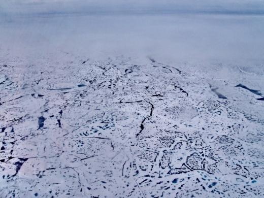
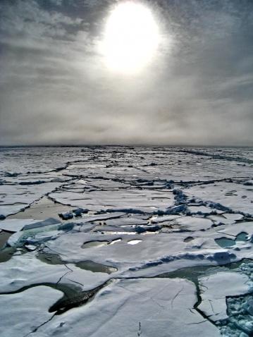
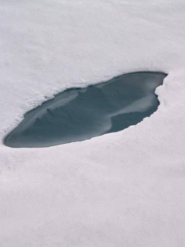

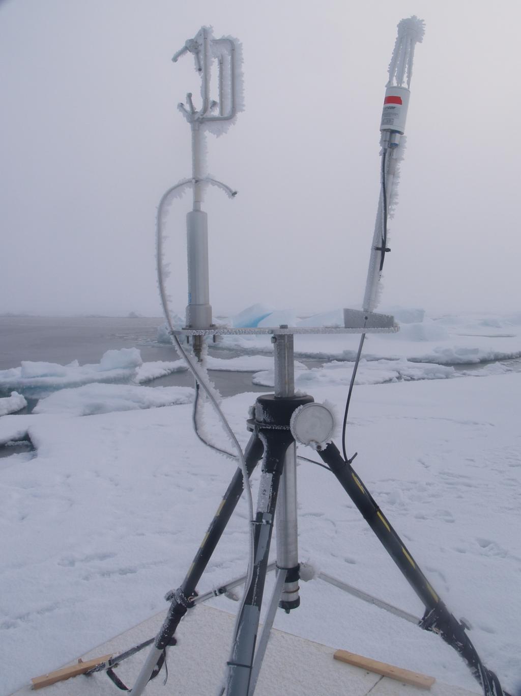
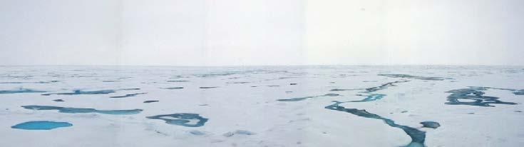
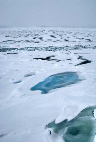
3 In the central Arctic, almost all in situ atmospheric observations are field data, one way or the other Surface obs Aircraft obs Soundings / Michael Tjernström, MISU Buoys &ships

4 / Michael Tjernström, MISU
5 Data without a model is chaos but a model without data is guesswork (Patrick Crill, Stockholm Uni.) Expanding our knowledge reveal things we didn t know already Reveal process relationships understanding the system to improve model formulations Evaluate models in different ways / Michael Tjernström, MISU
 2013-06-25 / Michael Tjernström,")
6 Expanding knowledge: Mixed-phase clouds in cold climates Temperature (K) / Michael Tjernström, MISU


7 Vertical thermal structure ~400 m ~300 m ~300 m ~500 m / Michael Tjernström, Stockholm University


8 Surface inversion Winter Spring Summer Autumn Surface 53% 15% 9% 61% Lifted 47% 85% 91% 39% Lifted inversion Boundary layer / Michael Tjernström Tjernström & Graversen 2009


9 Vertical thermal structure / Michael Tjernström, Stockholm University Tjernström et al. 2012

10 AOE-2001 ASCOS Moisture invesions / Michael Tjernström, MISU


11 CloudSat limit Cloud base < 200 m Summer cloud conditions / Michael Tjernström, Stockholm University CloudSat limit Cloud top < 1 km Tjernström et al. 2012


12 500 Clod top to inversion base (m) Frequency (%) / Michael Tjernström, MISU Sedlar et al. 2012

13 Aerosols, CCN and cloud interactions / Michael Tjernström, MISU Mauritsen et al. 2011


14 Optically thin clouds / Michael Tjernström, MISU
15 Optically thin clouds arosol/cloud interactions / Michael Tjernström, Stockholm University Birch et al. 2012

16 g Θ Ri = Θ z 2 U z Richardson number, Ri / Michael Tjernström, Stockholm University Day of August 2008


17 Cloud generated turbulent layer Partial decoupling layer Surface based boundary layer / Michael Tjernström, Stockholm University
18 Data without a model is chaos but a model without data is guesswork (Patrick Crill, Stockholm Uni.) Expanding our knowledge reveal things we didn t know already Reveal process relationships understanding the system to improve model formulations Evaluate models in different ways / Michael Tjernström, MISU
19 Process relationships: understanding the system Non-melt season: Variable T s < 0 C Melt season: Fixed T s 0 C / Michael Tjernström, Stockholm University Persson 2011

20 SHEBA Polar Night / Michael Tjernström, Stockholm University Courtesy of Persson 2012

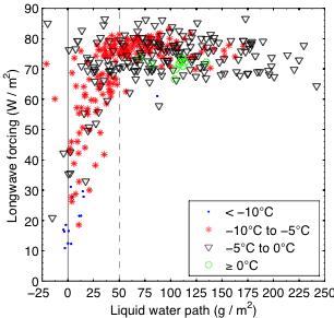
21 The effects of clouds on the surface energy balance 27 May, 2010 / Michael Tjernström, Stockholm University Sedlar et al. 2010


22 Dependences in cloud forcing 27 May, 2010 / Michael Tjernström, Stockholm University Sedlar et al. 2010
23 Data without a model is chaos but a model without data is guesswork (Patrick Crill, Stockholm Uni.) Expanding our knowledge reveal things we didn t know already Reveal process relationships understanding the system to improve model formulations Evaluate models in different ways / Michael Tjernström, MISU
24 / Michael Tjernström, MISU Tjernström et al. 2012


25 Climate & bias? Polar MM5 RCA / Michael Tjernström, MISU
26 First order approximation: U * /U 10 ~ C D 1/2 F H /U 10 ~ - C H (T 2 T s ) F Q /U 10 ~ - C H (q 2 q s (T s )) / Michael Tjernström, MISU Tjernström et al. 2005

27 Shit in, shit out? / Michael Tjernström, MISU
28 / Michael Tjernström, MISU Compensating errors in radiation

29 Clouds in regional models / Michael Tjernström, Stockholm University Tjernström et al. 2008

30 Clouds in regional models Too low optical thickness in longwave calculations Too high optical thickness in shortwave calculations 25/06/ May, 2010 / Michael Tjernström, Stockholm University Tjernström et al. 2008
31 Two versions of the Arctic System Reanalysis, (ASR) Polar-WRF driven by ERA Interim, and ERA-Interim by itself / Michael Tjernström, MISU Wesslèn et al. 2013

32 / Michael Tjernström, MISU Wesslèn et al. 2013


33 Vertical profiles ASR-1 ASR-2 ERA-I / Michael Tjernström, MISU Wesslèn et al. 2013
34 Cloud properties / Michael Tjernström, MISU Wesslèn et al. 2013


35 / Michael Tjernström, MISU Wesslèn et al. 2013

36 / Michael Tjernström, MISU Wesslèn et al. 2013
37 Some thoughts A poor model will always be a poor model, no matter how much data assimilation is used. Poor models do poor forecasts eventually A good model is a model with a realistic climate for the right reasons. To make a good model requires an inevitable empirical component Even if a model can be evaluated against routine observations, a correct result may still come from compensating errors in different processes; hence the need to evaluate processes Special Challenges: Stable winter boundary layers Mixed phase clouds Optically thin clouds and aerosols / Michael Tjernström, MISU
38 Some recommendations Close collaboration between modeling and observational centers - and the academic community, using the best characteristics of each group For the PPP: Start with a canvas of what good field experiment data is already available and set up a series of modeling experiments do it now! Longer term field observations in the Arctic are extremely expensive and very demanding and it is difficult for the academic community to access the levels of policymaking where decisive funding action can be taken; national met centers have a more direct access to government let s scratch each other s back International coordination is key! / Michael Tjernström, MISU
Conditions for Offshore Wind Energy Use
 Carl von Ossietzky Universität Oldenburg Institute of Physics Energy Meteorology Group Detlev Heinemann Conditions for Offshore Wind Energy Use Detlev Heinemann ForWind Carl von Ossietzky Universität Oldenburg
Chapter 2. Turbulence and the Planetary Boundary Layer
 Chapter 2. Turbulence and the Planetary Boundary Layer In the chapter we will first have a qualitative overview of the PBL then learn the concept of Reynolds averaging and derive the Reynolds averaged
Thermodynamic Boundary Layer profiles
 Thermodynamic Boundary Layer profiles Model and Aircraft data from the VOCALS 2008 Stratocumulus field campaign Paul Barrett July 2009 2 nd VOCALS MEETING Seattle, July 2009 Thermodynamics vl BEGIN ANALYSIS
LES* IS MORE! * L ARGE E DDY S IMULATIONS BY VORTEX. WindEnergy Hamburg 2016
 LES* IS MORE! * L ARGE E DDY S IMULATIONS BY VORTEX WindEnergy Hamburg 2016 OUTLINE MOTIVATION Pep Moreno. CEO, BASIS Alex Montornés. Modelling Specialist, VALIDATION Mark Žagar. Modelling Specialist,
Modelling atmospheric stability with CFD: The importance of tall profiles
 ENERGY Modelling atmospheric stability with CFD: The importance of tall profiles VindKraftNet Seminar on Profiles Jean-François Corbett, Global Head of CFD Service 1 SAFER, SMARTER, GREENER DNV GL CFD
Incompressible Potential Flow. Panel Methods (3)
") Incompressible Potential Flow Panel Methods (3) Outline Some Potential Theory Derivation of the Integral Equation for the Potential Classic Panel Method Program PANEL Subsonic Airfoil Aerodynamics Issues
Incompressible Potential Flow Panel Methods (3) Outline Some Potential Theory Derivation of the Integral Equation for the Potential Classic Panel Method Program PANEL Subsonic Airfoil Aerodynamics Issues
2.4. Applications of Boundary Layer Meteorology
 2.4. Applications of Boundary Layer Meteorology 2.4.1. Temporal Evolution & Prediction of the PBL Earlier, we saw the following figure showing the diurnal evolution of PBL. With a typical diurnal cycle,
Atmospheric Dispersion, Transport and Deposition. Dispersion. Wind Speed. EOH 468 Spring 2008 Dr. Peter Bellin, CIH, Ph.D.
 Atmospheric Dispersion, Transport and Deposition EOH 468 Spring 2008 Dr. Peter Bellin, CIH, Ph.D. Dispersion Atmospheric process affect dilution. Wind speed and lapse rate impact on emissions. Planetary
Vertical Motion and Atmospheric Stability
 Lesson 4 Vertical Motion and Atmospheric Stability This lesson describes the vertical structure of the atmosphere, atmospheric stability and the corresponding vertical motion. Adiabatic diagrams are introduced
Evaluation of ACME coupled simulation Jack Reeves Eyre, Michael Brunke, and Xubin Zeng (PI) University of Arizona 4/19/3017
 University of Arizona 4/19/3017") Evaluation of ACME coupled simulation Jack Reeves Eyre, Michael Brunke, and Xubin Zeng (PI) University of Arizona 4/19/3017 1. Introduction We look at surface variables in the tropical Pacific from a coupled
Evaluation of ACME coupled simulation Jack Reeves Eyre, Michael Brunke, and Xubin Zeng (PI) University of Arizona 4/19/3017 1. Introduction We look at surface variables in the tropical Pacific from a coupled
CHANGE OF THE BRIGHTNESS TEMPERATURE IN THE MICROWAVE REGION DUE TO THE RELATIVE WIND DIRECTION
 JP4.12 CHANGE OF THE BRIGHTNESS TEMPERATURE IN THE MICROWAVE REGION DUE TO THE RELATIVE WIND DIRECTION Masanori Konda* Department of Geophysics, Graduate School of Science, Kyoto University, Japan Akira
1. Large-scale temperature inversions.
 Lecture 18. Local and regional pollution issues: plumes of pollution. Objectives: 1. Large-scale temperature inversions. 2. Plumes of pollution. Readings: Turco: p.128-135; Brimblecombe: p.130-138 1. Large-scale
Wind turning in the boundary layer - observations and comparison with CMIP5 models
 in the boundary layer - observations and comparison with CMIP5 models Jenny Lindvall, Gunilla Svensson Department of Meteorology and Bolin Centre for Climate Research, Stockholm University Swedish e-science
Stefan Emeis
 The Physics of Wind Park Optimization Stefan Emeis stefan.emeis@kit.edu INSTITUTE OF METEOROLOGY AND CLIMATE RESEARCH, Photo: Vattenfall/C. Steiness KIT University of the State of Baden-Wuerttemberg and
REMINDERS: Problem Set 2: Due Monday (Feb 3)
") REMINDERS: Problem Set 2: Due Monday (Feb 3) Midterm 1: Next Wednesday, Feb 5 - Lecture material covering chapters 1-5 - Multiple Choice, Short Answers, Definitions - Practice midterm will be on course
REMINDERS: Problem Set 2: Due Monday (Feb 3) Midterm 1: Next Wednesday, Feb 5 - Lecture material covering chapters 1-5 - Multiple Choice, Short Answers, Definitions - Practice midterm will be on course
= y y. In meteorological parlance, terms such as the above are known as
 Mesoscale Meteorology: The Planetary Boundary Layer 8 March 017 Introduction The planetary boundary layer, sometimes referred to as the atmospheric boundary layer, is a layer of finite depth over which
Thorsten Mauritsen *, Gunilla Svensson Stockholm University, Stockholm, Sweden
 J.1 WAVE FLOW SIMULATIONS OVER ARCTIC LEADS Thorsten Mauritsen *, Gunilla Svensson Stockholm University, Stockholm, Sweden Branko Grisogono Department of Geophysics, Faculty of Science, Zagreb, Croatia
Chapter 4. Convec.on Adiaba.c lapse rate
 Chapter 4 Convec.on Adiaba.c lapse rate 1.Outline: a. air parcel theory, adiabatic processes b. how do we define/determine atmospheric stability? 2.Readings: Chapter 4 VERTICAL STRUCTURE T STRATIFICATION
2.2 THE DIURNAL CYCLE OF THE SUMMER CLOUD-CAPPED ARCTIC BOUNDARY LAYER Michael Tjernström* + CIRES/University of Colorado, Boulder
 2.2 THE DIURNAL CYCLE OF THE SUMMER CLOUD-CAPPED ARCTIC BOUNDARY LAYER Michael Tjernström* + CIRES/University of Colorado, Boulder 1. INTRODUCTION One of the most fundamental features of the conventional
A new mechanism of oceanatmosphere coupling in midlatitudes
 A new mechanism of oceanatmosphere coupling in midlatitudes Arnaud Czaja & Nicholas Blunt Imperial College, London Grantham Institute for Climate Change 1. Motivation Two key questions By which mechanism(s)
Atmospheric & Ocean Circulation-
 Atmospheric & Ocean Circulation- Overview: Atmosphere & Climate Atmospheric layers Heating at different latitudes Atmospheric convection cells (Hadley, Ferrel, Polar) Coriolis Force Generation of winds
FIVE YEARS OF OPERATION OF THE FIRST OFFSHORE WIND RESEARCH PLATFORM IN THE GERMAN BIGHT FINO1
 FIVE YEARS OF OPERATION OF THE FIRST OFFSHORE WIND RESEARCH PLATFORM IN THE GERMAN BIGHT FINO1 Andreas Beeken, DEWI GmbH, Ebertstraße 96, D-26382 Wilhelmshaven Thomas Neumann, DEWI GmbH, Ebertstraße 96,
Kathleen Dohan. Wind-Driven Surface Currents. Earth and Space Research, Seattle, WA
 Updates to OSCAR and challenges with capturing the wind-driven currents. Wind-Driven Surface Currents Kathleen Dohan Earth and Space Research, Seattle, WA ENSO OSCAR Surface currents from satellite fields
The Air-Sea Interaction. Masanori Konda Kyoto University
 2 The Air-Sea Interaction Masanori Konda Kyoto University 2.1 Feedback between Ocean and Atmosphere Heat and momentum exchange between the ocean and atmosphere Atmospheric circulation Condensation heat
Horizontal distance, x
 Height, z z i pping Free Atmosphere Inversion Boundary Layer Troposphere ~11 km ~2 km Earth Horizontal distance, x Adapted from Meteorology for Scientists and Engineers A Technical Companion Book to C.
4/29/2011. Concept of Stability Lapse Rates Determine Stability and Stability Indices. Air pressure decreases with elevation.
 Chapter 6: Stability Concept of Stability Concept of Stability Lapse Rates Determine Stability and Stability Indices Air Parcel Expands as It Rises Air Parcel Expands As It Rises Air pressure decreases
4.2 Pressure and Air Masses (6.3.2)
") 4.2 Pressure and Air Masses (6.3.2) Explore This Phenomena www.ck12.org Everybody loves a picnic. Your friends and you are headed up the canyon to enjoy the mountains. While driving you feel a slight discomfort
4.2 Pressure and Air Masses (6.3.2) Explore This Phenomena www.ck12.org Everybody loves a picnic. Your friends and you are headed up the canyon to enjoy the mountains. While driving you feel a slight discomfort
LOW LAYER WIND SHEAR OVER DAKAR
 LOW LAYER WIND SHEAR OVER DAKAR Dr Cheikh Sadibou SOW ASECNA Senior Meteorologist Abstract : Low layer wind shears are dangerous for planes. Their observation and study are one of the main fields where
METEOROLOGY OF FAIRBANKS WINTER: MAKING SENSE OF THAT CRAZY INVERSION
 METEOROLOGY OF FAIRBANKS WINTER: MAKING SENSE OF THAT CRAZY INVERSION Rick Thoman Climate Science and Services Manager National Weather Service Alaska Region What s an inversion and why should I care?
11.4 WIND STRESS AND WIND WAVE OBSERVATIONS IN THE PRESENCE OF SWELL 2. METHODS
 11.4 WIND STRESS AND WIND WAVE OBSERVATIONS IN THE PRESENCE OF SWELL Douglas Vandemark 1*, W. M. Drennan 2, J. Sun, 3 J. R. French 4 and Hans Graber 2 1 NASA/GSFC, Wallops Island, VA 2 Univ. of Miami,
Low cloud and poor visibility
 Low cloud and poor visibility Low cloud: Introduction Turbulent mixing low cloud Nocturnal stratus Forecasting formation and clearance of nocturnal stratus Example in satellite imagery Quiz Turbulent Mixing
Gravity waves and bores. Material kindly provided by Dr. Steven Koch GSD NOAA (Boulder, CO)
") Gravity waves and bores Material kindly provided by Dr. Steven Koch GSD NOAA (Boulder, CO) Presented at Iowa State University 11 April 2005 What is a gravity wave? An oscillation caused by the displacement
Gravity waves and bores Material kindly provided by Dr. Steven Koch GSD NOAA (Boulder, CO) Presented at Iowa State University 11 April 2005 What is a gravity wave? An oscillation caused by the displacement
Toward a global view of extratropical UTLS tracer distributions. SPARC GA Sept Michaela I. Hegglin University of Toronto, Canada
 Toward a global view of extratropical UTLS tracer distributions Michaela I. Hegglin University of Toronto, Canada SPARC General Assembly 2004: PERSPECTIVE Knowledge about UTLS tracer distributions was
Adiabatic Lapse Rates and Atmospheric Stability
 8 Adiabatic Lapse Rates and Atmospheric Stability Learning Goals After studying this chapter, students should be able to: 1. describe adiabatic processes as they apply to the atmosphere (p. 174); 2. apply
Experience with the representation of stable conditions in the ECMWF model
 Experience with the representation of stable conditions in the ECMWF model Irina Sandu Anton Beljaars, Gianpaolo Balsamo, Peter Bechtold, Mark Rodwell 1. Stable conditions: current issues 2. Land-atmosphere
The change in temperature as air rises or descends d in the atmosphere. This change is measured by a lapse rate
 Adiabatics The change in temperature as air rises or descends d in the atmosphere. This change is measured by a lapse rate oftenplotted on an adiabatic chart. Such processes are closely connected to precipitation
Polar storms and polar jets: Mesoscale weather systems in the Arctic & Antarctic
 Polar storms and polar jets: Mesoscale weather systems in the Arctic & Antarctic Ian Renfrew School of Environmental Sciences, University of East Anglia ECMWF-WWRP/Thorpex Polar Prediction Workshop 24-27
Low level coastal jet
 MetOcean analysis of a low-level coastal jet off the Norwegian coast. EERA DeepWind'2014 Deep Sea Offshore Wind R&D Conference, Trondheim, 22-24 January 2014 Harokopio University Konstantinos Christakos,
High-resolution simulations of mountain weather improved with observations from small unmanned aircraft
 High-resolution simulations of mountain weather improved with observations from small unmanned aircraft Hálfdán Ágústsson, Haraldur Ólafsson, Marius O. Johannessen, Joachim Reuder, Dubravka Rasol and Ólafur
3.3 USING A SIMPLE PARCEL MODEL TO INVESTIGATE THE HAINES INDEX
 3.3 USING A SIMPLE PARCEL MODEL TO INVESTIGATE THE HAINES INDEX Mary Ann Jenkins 1 Steven K. Krueger 2 and Ruiyu Sun 2 1 York University, Toronto, Canada 2 University of Utah, Salt Lake City, Utah 1. INTRODUCTION
Seasonal Evaluation of Temperature Inversion
 Seasonal Evaluation of Temperature Inversion Kandil, H A 1, Kader M M. A 2, Moaty, A A. 2, Elhadidi, B 3, Sherif, A.O. 3 The seasonal evaluation of the temperature inversion over Cairo-Egypt is examined
Turbulence forecasts based on upper-air soundings
 OC3570 Turbulence forecasts based on upper-air soundings By Greg Ireton Introduction The objective of this paper is to make turbulence forecasts from upper-air data by making Richardson s number calculations
Dust radiative forcing and Heat Low dynamics over West Africa
 Dust radiative forcing and Heat Low dynamics over West Africa Cyrille Flamant 1, Juan Cuesta 2, Christophe Lavaysse 3, Ridha Guebsi 1, Marco Gaetani 1, Wenje Wang 4 & Amato Evan 4 1 LATMOS/IPSL, UPMC Univ.
ENVIRONMENTAL PHYSICS
 ENVIRONMENTAL PHYSICS Atmospheric Stability An understanding of why and how air moves in the atmosphere is fundamental to the prediction of weather and climate. What happens to air as it moves up and down
Chapter 3 Atmospheric Thermodynamics
 Chapter 3 Atmospheric Thermodynamics Spring 2017 Partial Pressure and Dalton Dalton's law of partial pressure: total pressure exerted by a mixture of gases which do not interact chemically is equal to
A Numerical Simulation of Convectively Induced Turbulence (CIT) above Deep Convection
 above Deep Convection") A Numerical Simulation of Convectively Induced Turbulence (CIT) above Deep Convection Jung-Hoon Kim and Hye-Yeong Chun Department of Atmospheric Sciences Yonsei University, Seoul, Korea 1. Introduction
A Numerical Simulation of Convectively Induced Turbulence (CIT) above Deep Convection Jung-Hoon Kim and Hye-Yeong Chun Department of Atmospheric Sciences Yonsei University, Seoul, Korea 1. Introduction
ON THE PHYSICAL PROCESSES THAT INFLUENCE THE DEVELOPMENT OF THE MARINE LOW-LEVEL JET
 Proceedings of the 13 th International Conference on Environmental Science and Technology Athens, Greece, 5-7 September 2013 ON THE PHYSICAL PROCESSES THAT INFLUENCE THE DEVELOPMENT OF THE MARINE LOW-LEVEL
Abrupt marine boundary layer changes revealed by airborne in situ and lidar measurements
 Abrupt marine boundary layer changes revealed by airborne in situ and lidar measurements David A. Rahn 1, Thomas R. Parish 2, and David Leon 2 1 Univeristy of Kansas 2 Univeristy of Wyoming Precision Atmospheric
Performance of three Selected Convective Schemes for Predicting Indian Summer Monsoon Rainfall using RegCM4.4
 Performance of three Selected Convective Schemes for Predicting Indian Summer Monsoon Rainfall using RegCM4.4 A.K.M. Saiful Islam Professor Institute of Water and Flood Management Bangladesh University
Marius O. Jonassen, Stephan T. Kral, Siiri Wickström, John J. Cassano, Daniel Martinez, Martin Müller, Christian Lindenberg, Line Båserud
 Marius O. Jonassen, Stephan T. Kral, Siiri Wickström, John J. Cassano, Daniel Martinez, Martin Müller, Christian Lindenberg, Line Båserud Introduction Where: Svalbard How: During a graduate course at the
RECTIFICATION OF THE MADDEN-JULIAN OSCILLATION INTO THE ENSO CYCLE
 RECTIFICATION OF THE MADDEN-JULIAN OSCILLATION INTO THE ENSO CYCLE By William S. Kessler and Richard Kleeman Journal of Climate Vol.13, 1999 SWAP, May 2009, Split, Croatia Maristella Berta What does give
Xiaoli Guo Larsén,* Søren Larsen and Andrea N. Hahmann Risø National Laboratory for Sustainable Energy, Roskilde, Denmark
 Quarterly Journal of the Royal Meteorological Society Q. J. R. Meteorol. Soc. 138: 274 279, January 2012 A Notes and Correspondence Origin of the waves in A case-study of mesoscale spectra of wind and
Mesoscale Atmospheric Systems. Upper-level fronts. 13 and 20 March 2018 Heini Wernli. 13 March 2018 H. Wernli 1
 Mesoscale Atmospheric Systems Upper-level fronts 13 and 20 March 2018 Heini Wernli 13 March 2018 H. Wernli 1 Upper-level fronts Formation of fronts is favored by presence of quasi-horizontal boundaries:
ATS 351 Lecture 6. Air Parcel. Air Parcel Movement: Why does rising air expand and cool? Stability & Skew-T Diagrams
 ATS 351 Lecture 6 Stability & Skew-T Diagrams To demonstrate stability, a parcel of air is used Expands and contracts freely Always has uniform properties throughout Air Parcel Air Parcel Movement: Why
Exploring wave-turbulence interaction through LES modeling
 Exploring wave-turbulence interaction through LES modeling Mireia Udina 1 Jielun Sun 2 M. Rosa Soler 1 Branko Kosović 2 1. Dept. Astronomia i Meteorologia Universitat de Barcelona, Barcelona, Catalunya
Local Winds. Please read Ahrens Chapter 10
 Local Winds Please read Ahrens Chapter 10 Scales of Motion Microscale: meters Turbulent eddies Formed by mechanical disturbance or convection Lifetimes of minutes Mesoscale: km s to 100 s of km s Local
Meteorology. Circle the letter that corresponds to the correct answer
 Chapter 4 Worksheet 3 Meteorology Name: Circle the letter that corresponds to the correct answer 1) Natural convection and turbulence are most likely to occur when: a) temperature decreases rapidly with
Nearshore Wind-Wave Forecasting at the Oregon Coast. Gabriel García, H. Tuba Özkan-Haller, Peter Ruggiero November 16, 2011
 Nearshore Wind-Wave Forecasting at the Oregon Coast Gabriel García, H. Tuba Özkan-Haller, Peter Ruggiero November 16, 2011 What is Wave Forecasting? An attempt to predict how the ocean surface is going
Satellite information on ocean vector wind from Scatterometer data. Giovanna De Chiara
 Satellite information on ocean vector wind from Scatterometer data Giovanna De Chiara Why is Scatterometer important? The scatterometer measures the ocean surface winds (ocean wind vector). Ocean surface
Downslope Wind Storms
 Downslope Wind Storms How does acceleration over the wing affect pressure field? Equation of Motion for frictionless flow: V t = l k α p+g If we assume a horizontally homogeneous, hydrostatic reference
Development of a Regional Coupled Ocean-Atmosphere Model
 2.2 Development of a Regional Coupled Ocean-Atmosphere Model Hyodae Seo, Arthur J. Miller, John O. Roads, and Masao Kanamitsu Scripps Institution of Oceanography 6th Conference on Coastal Atmospheric and
Development of model physics at ECMWF
 Development of model physics at Anton Beljaars () Example of physics related output Physics changes after ERA-40 (CY23R4) Evolution of spin-up in operations after CY23R4 Examples of changes with respect
Surface Fluxes and Wind-Wave Interactions in Weak Wind Conditions
 Surface Fluxes and Wind-Wave Interactions in Weak Wind Conditions Jielun Sun Microscale and Mesoscale Meteorology National Center for Atmospheric Research phone: (303) 497-8994 fax: (303) 497-8171 email:
WESEP 594 Research Seminar
 WESEP 594 Research Seminar Aaron J Rosenberg Department of Aerospace Engineering Iowa State University Major: WESEP Co-major: Aerospace Engineering Motivation Increase Wind Energy Capture Betz limit: 59.3%
The Offshore Boundary Layer Observatory (OBLO) Possibilities for the offshore wind industry
 Possibilities for the offshore wind industry") The Offshore Boundary Layer Observatory (OBLO) Possibilities for the offshore wind industry Prof. Peter Haugan, Prof. Joachim Reuder Geophysical Institute, NORCOWE Science Meets Industry 08. November 2016,
The Offshore Boundary Layer Observatory (OBLO) Possibilities for the offshore wind industry Prof. Peter Haugan, Prof. Joachim Reuder Geophysical Institute, NORCOWE Science Meets Industry 08. November 2016,
Strengthening of the tropopause inversion layer during the 2009 sudden stratospheric warming in the MERRA-2 analysis
 Strengthening of the tropopause inversion layer during the 009 sudden stratospheric warming in the MERRA- analysis K. Wargan and L. Coy Global Modeling and Assimilation Office Outline We use the MERRA-
Implementation of the Lake Model in LM. Present Status.
 Implementation of the Lake Model in LM. Present Status. Dmitrii Mironov German Weather Service (DWD), Offenbach am Main, Germany Natalia Schneider, Bodo Ritter, and Erdmann Heise (DWD) Outline The Lake
Investigation on Deep-Array Wake Losses Under Stable Atmospheric Conditions
 Investigation on Deep-Array Wake Losses Under Stable Atmospheric Conditions Yavor Hristov, Mark Zagar, Seonghyeon Hahn, Gregory Oxley Plant Siting and Forecasting Vestas Wind Systems A/S Introduction Introduction
LAB 1 THERMODYNAMIC DIAGRAMS 100 points Part 2 Date Due
 LAB 1 THERMODYNAMIC DIAGRAMS 100 points Part 2 Date Due Thermodynamic diagrams allow for analysis of temperature, moisture, pressure and wind in the atmosphere. These vertical measurements, or soundings,
Analysis of katabatic flow using infrared imaging at micro- and mesoscale
 AMS - Boundary Layers and Turbulence 06/10/2014 Analysis of katabatic flow using infrared imaging at micro- and mesoscale Analysis of katabatic flow using infrared imaging at micro- and mesoscale Martina
Observed Roughness Lengths for Momentum and Temperature on a Melting Glacier Surface
 5 Observed Roughness Lengths for Momentum and Temperature on a Melting Glacier Surface The roughness lengths for momentum and temperature are calculated on a melting glacier surface. Data from a five level
Variability in the tropical oceans - Monitoring and prediction of El Niño and La Niña -
 Variability in the tropical oceans - Monitoring and prediction of El Niño and La Niña - Jun ichi HIROSAWA Climate Prediction Division Japan Meteorological Agency SST anomaly in Nov. 1997 1 ( ) Outline
Atmospheric Stability & Cloud Development
 Atmospheric Stability & Cloud Development This section looks at the basic cause of stability and instability in the atmosphere. Why some clouds are like tall towers, others huge flat sheets. We shall look
Envs, Geol, Phys 112: Global Climate. Energy-Atmosphere System Review Aguado & Bert, Ch. 1, 2, 3, 4, 5, 6, 9, 10
 Exam 1 Review Energy-Atmosphere System Review Aguado & Bert, Ch. 1, 2, 3, 4, 5, 6, 9, 10 Location on Earth (L04) Latitude & Longitude great circles, prime meridian, time zones, cardinal points, azimuth
Dynamics and variability of surface wind speed and divergence over mid-latitude ocean fronts
 Dynamics and variability of surface wind speed and divergence over mid-latitude ocean fronts Larry O Neill 1, Tracy Haack 2, and Simon de Szoeke 1 1 Oregon State University, Corvallis, OR 2 Naval Research
ValidatingWindProfileEquationsduringTropicalStormDebbyin2012
 Global Journal of Researches in Engineering: e Civil And Structural Engineering Volume 4 Issue Version. Year 24 Type: Double Blind Peer Reviewed International Research Journal Publisher: Global Journals
COnstraining ORographic Drag Effects (COORDE)
") COnstraining ORographic Drag Effects (COORDE) A GASS/WGNE Modeling Intercomparison Project Annelize van Niekerk and Irina Sandu Contents 1 Introduction....................................................
COnstraining ORographic Drag Effects (COORDE) A GASS/WGNE Modeling Intercomparison Project Annelize van Niekerk and Irina Sandu Contents 1 Introduction....................................................
DUE TO EXTERNAL FORCES
 17B.6 DNS ON GROWTH OF A VERTICAL VORTEX IN CONVECTION DUE TO EXTERNAL FORCES Ryota Iijima* and Tetsuro Tamura Tokyo Institute of Technology, Yokohama, Japan 1. INTRODUCTION Various types of vertical vortices,
Mesoscale air-sea interaction and feedback in the western Arabian Sea
 Mesoscale air-sea interaction and feedback in the western Arabian Sea Hyodae Seo (Univ. of Hawaii) Raghu Murtugudde (UMD) Markus Jochum (NCAR) Art Miller (SIO) AMS Air-Sea Interaction Workshop Phoenix,
1. Atmospheric Diffusion of Stack Gases
 1. Atmospheric Diffusion of Stack Gases 5F: Atmospheric Diffusion & Field Experiment Atmospheric diffusion is the process of diluting air pollutants by atmospheric turbulences. Historically, Taylor, G.I.
Stormy Weather. tropopause. z i
 Stormy Weather tropopause z i z x High Low Stormy Weather Tropopausez Venting by thunderstorms y Venting by fronts x Stormy Weather Height, z tropopause clouds clouds z i BL n cold air warm air z i BL
Chapter 8 Air Masses
 Chapter 8 Air Masses Air Masses - 1 1. An Air Mass is a large body of air usually about 1500 km across and several km thick, that has homogeneous physical properties. 2. The important physical properties
Answer in your notes:
 Hail, Dew, Frost Answer in your notes: 1. Starting with water at ground level, describe in your own words how a cloud forms. Include the energy flow that occurs at each stage. 2. Starting with evaporation
Global Circulations. GEOG/ENST 2331 Lecture 15 Ahrens: Chapter 10
 Global Circulations GEOG/ENST 2331 Lecture 15 Ahrens: Chapter 10 Last lecture Microscale (turbulence) Mesoscale (land/sea breeze) Synoptic scale (monsoon) Global scale (3 cell circulation) Three Cell Model
Atmospheric Waves James Cayer, Wesley Rondinelli, Kayla Schuster. Abstract
 Atmospheric Waves James Cayer, Wesley Rondinelli, Kayla Schuster Abstract It is important for meteorologists to have an understanding of the synoptic scale waves that propagate thorough the atmosphere
An adiabatic unsaturated air parcel is displaced downwards a short distance and accelerates upwards towards its original if the density of the air
 An adiabatic unsaturated air parcel is displaced downwards a short distance and accelerates upwards towards its original if the density of the air parcel after displacement is (greater/less) than the density
JCOMM Technical Workshop on Wave Measurements from Buoys
 JCOMM Technical Workshop on Wave Measurements from Buoys Val Swail Chair, JCOMM Expert Team on Wind Waves and Storm Surges Neville Smith Vincent Cardone Peter Janssen Gerbrand Komen Peter Taylor WIND WAVES
Super-parameterization of boundary layer roll vortices in tropical cyclone models
 DISTRIBUTION STATEMENT A. Approved for public release; distribution is unlimited. Super-parameterization of boundary layer roll vortices in tropical cyclone models PI Isaac Ginis Graduate School of Oceanography
The Hydrological Cycle
 Introduction to Climatology GEOGRAPHY 300 The Hydrological Cycle Tom Giambelluca University of Hawai i at Mānoa Atmospheric Moisture Changes of Phase of Water Changes of Phase of Water 1 Changes of Phase
Characteristics of the Boundary Layer Structure of Sea Fog on the Coast of Southern China
 ADVANCES IN ATMOSPHERIC SCIENCES, VOL. 28, NO. 6, 2011, 1377 1389 Characteristics of the Boundary Layer Structure of Sea Fog on the Coast of Southern China HUANG Huijun 1,2 ( ), LIU Hongnian 1 (4ùc), JIANG
Cool Science Convection.. Take away concepts and ideas. State Properties of Air
 Thermal Structure of the Atmosphere: Lapse Rate, Convection, Clouds Cool Science 2007 Lamont Open House Saturday, October 4th 10am - 4pm Free Shuttle buses to / from Amsterdam & 118th: 9:30am, every 30
A Wet-Season Rainfall Climatology to Support Airline Arrivals at Key West Matthew Bloemer and Andy Devanas NWS WFO Key West, FL
 A Wet-Season Rainfall Climatology to Support Airline Arrivals at Key West Matthew Bloemer and Andy Devanas NWS WFO Key West, FL Introduction and Motivations The Island of Key West is served by an airport
(20 points) 1. ENSO is a coupled climate phenomenon in the tropical Pacific that has both regional and global impacts.
 1. ENSO is a coupled climate phenomenon in the tropical Pacific that has both regional and global impacts.") SIO 210 Problem Set 4 Answer key December 1, 2014 Due Dec. 12, 2014 (20 points) 1. ENSO is a coupled climate phenomenon in the tropical Pacific that has both regional and global impacts. (2 points) a)
SIO 210 Problem Set 4 Answer key December 1, 2014 Due Dec. 12, 2014 (20 points) 1. ENSO is a coupled climate phenomenon in the tropical Pacific that has both regional and global impacts. (2 points) a)
ASSESSMENT OF SEA BREEZE CHARACTERISTICS FROM SODAR ECHOGRAMS
 ASSESSMENT OF SEA BREEZE CHARACTERISTICS FROM SODAR ECHOGRAMS SUNEETHA RANI. JUPUDI Prof. M. PURNACHANDRA RAO Department of Physics, Andhra University, Visakhapatnam, India. ABSTRACT The SODAR echograms
The Use of Bulk and Profile Methods for Determining Surface Heat Fluxes in the Presence of Glacier Winds
 3 The Use of Bulk and Profile Methods for Determining Surface Heat Fluxes in the Presence of Glacier Winds A -D second-order closure model and in situ observations on a melting glacier surface are used
Review for the second quarter. Mechanisms for cloud formation
 Review for the second quarter Mechanisms for cloud formation 1 Rising air expands and cools; Sinking air compresses and warms. (18) (24) Dry adiabatic lapse rate (10 o C/km): the rate of temperature decrease
Wintertime intraseasonal SST variability in the tropical South Indian Ocean and Role of Ocean Dynamics in the MJO Initiation
 Wintertime intraseasonal SST variability in the tropical South Indian Ocean and Role of Ocean Dynamics in the MJO Initiation Weiqing Han & Yuanlong Li ATOC, University of Colorado at Boulder, Boulder,
Ocean Spinup in CESM. Current issues and discussion. Cécile Hannay, Rich Neale and Joe Tribbia Atmospheric Modeling and Predictability (CGD/NCAR)
") Ocean Spinup in CESM. Current issues and discussion. Cécile Hannay, Rich Neale and Joe Tribbia Atmospheric Modeling and Predictability (CGD/NCAR) Keith Lindsay and Gokhan Danabasoglu Oceanography Section
Ocean Spinup in CESM. Current issues and discussion. Cécile Hannay, Rich Neale and Joe Tribbia Atmospheric Modeling and Predictability (CGD/NCAR) Keith Lindsay and Gokhan Danabasoglu Oceanography Section
Parameterizations (fluxes, convection)
") Parameterizations (fluxes, convection) Heinke Schlünzen Meteorological Institute, University of Hamburg New resolutions - new challenges What is the current status? Surface fluxes Convection Towards improving
Parameterizations (fluxes, convection) Heinke Schlünzen Meteorological Institute, University of Hamburg New resolutions - new challenges What is the current status? Surface fluxes Convection Towards improving
Jackie May* Mark Bourassa. * Current affilitation: QinetiQ-NA
 Jackie May* Mark Bourassa * Current affilitation: QinetiQ-NA Background/Motivation In situ observations (ships and buoys) are used to validate satellite observations Problems with comparing data Sparseness