Low cloud and poor visibility
|
|
|
- Chester Bailey
- 6 years ago
- Views:
Transcription

1 Low cloud and poor visibility Low cloud: Introduction Turbulent mixing low cloud Nocturnal stratus Forecasting formation and clearance of nocturnal stratus Example in satellite imagery Quiz
2 Turbulent Mixing Low Cloud Caused by low level moisture and wind shear in the boundary layer: Responsible for the formation of St and Sc Turbulent stratus Nocturnal stratus Stratocumulus Crown copyright 2004 Page 2
3 Turbulent Stratus and Stratocumulus Need to know the depth of the Mixing Layer (d) Identify a layer, ideally topped by an inversion In this example use the layer 1000 to 900 hpa 0 Midday ascent d Crown copyright 2004 Page 3
4 Turbulent Stratus and Stratocumulus In the absence of an inversion use the following empirical rule: V s 16kt then d = 200V s V s 16kt then d = 3500ft (night) or d = 4000ft (day) Where V s = surface wind speed and d = depth of mixing layer 0 Midday ascent Crown copyright 2004 Page 4 10 d
5 Turbulent Stratus and Stratocumulus Mixing causes the ELR to become approximately equal to DALR in time The line should be altered such that there are equal areas either side of the original ELR Crown copyright 2004 Page 5
6 Turbulent Stratus and Stratocumulus Mixing also causes hydrolapse = SHMR The line should be altered such that there are equal areas either side of the original hydrolapse Crown copyright 2004 Page 6
7 Turbulent Stratus and Stratocumulus Where the two lines cross is the Mixing Condensation Level, i.e., the cloud base Note that surface temperature has risen and dew point fallen 0 MCL This is common when stratus forms at night Crown copyright 2004 Page 7
8 Turbulent Stratus and Stratocumulus Cloud may form between the MCL and the top of the Mixing Layer Resulting profile follows the SALR through the cloud 0 MCL Crown copyright 2004 Page 8
9 Nocturnal stratus 1) Calculate T fog Saunders fog technique 2) Determine top of surface mixing layer (h) h 75 x surface wind speed 3) Calculate T st Saunders stratus technique Crown copyright 2004 Page 9
10 Saunders stratus formation technique Use Saunders method to find the fog point, T f 7 Mark on top of surface mixing layer (h) Draw HMR to h h 9 Draw DALR to surface pressure T f 1000 Read off T st T st 0 10 Crown copyright 2004 Page 10
11 Nocturnal stratus 1) Calculate T fog Saunders fog technique 2) Determine top of surface mixing layer (h) h 75 x surface wind speed 3) Calculate T st Saunders stratus technique Alternative methods Crown copyright 2004 Page 11
12 Alternative methods Temperature where stratus is already present The morning s stratus clearance temperature minus 1 or 2 C The sea temperature if stratus is likely to be advected in from the sea Crown copyright 2004 Page 12
13 Nocturnal stratus 1) Calculate T fog Saunders fog technique 2) Determine top of surface mixing layer (h) h 75 x surface wind speed 3) Calculate T st Saunders stratus technique 4) Determine height of stratus Height = (T st T dew ) x 350 Crown copyright 2004 Page 13
14 When will stratus clear? Three mechanisms Insolation Increased wind Advection of drier air Crown copyright 2004 Page 14
15 Clearance by insolation Mixing layer SALR MCL 7 Draw a DALR from the stratus top to the surface pressure Clearance temp 0 10 Crown copyright 2004 Page 15
16 Clearance by increased wind Increasing the wind speed will deepen the mixing layer Wet bulb potential temperature mintra Crown copyright 2004 Page mixing layer
17 Clearance by increased wind and can mix drier air from above into the cloudy layer which may disperse the stratus Wet bulb potential temperature mintra Crown copyright 2004 Page mixing layer
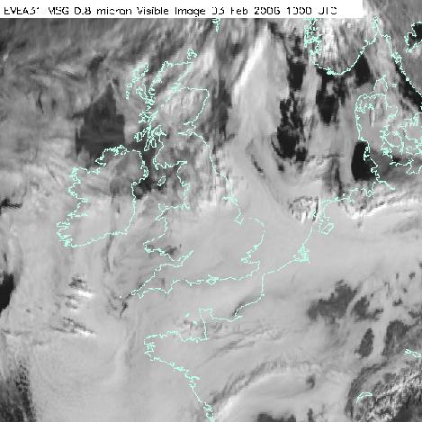
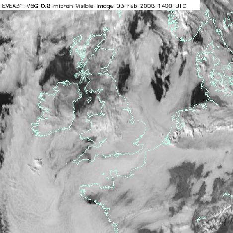
18 Clearance by advection of drier air Drier air from another source may clear the stratus Use satellite pictures to observe rear edge of stratus Example follows. Crown copyright 2004 Page 18

19 Area of drier air spreads south west with time
20

21

22

23
24

25
26 LOW CLOUD FORECASTING QUIZ 1. What are the 2 main factors required for the formation of low cloud? 2. What is the relationship between the height of the base of stratus, the air temperature and the dewpoint? 3. What are the 3 primary ways of clearing stratus? 4. What 2 features on a tephigram can mark the top of a layer of cloud? Crown copyright 2004 Page 26
27 LOW CLOUD FORECASTING QUIZ 1. What are the 2 main factors required for the formation of low cloud? ANS: Low level moisture and turbulence (wind shear) 2. What is the relationship between the height of the base of stratus, the air temperature and the dewpoint? ANS: H st = (T S t - T dew ) x What are the 3 primary ways of clearing stratus? ANS: Increasing wind; drier air; insolation 4. What 2 features on a tephigram can mark the top of a layer of cloud? ANS: Inversion; isothermal. Crown copyright 2004 Page 27
28 Forward to Diagnosing low cloud and fog using satellite imagery Crown copyright 2004 Page 28
Adiabatic Lapse Rates and Atmospheric Stability
 8 Adiabatic Lapse Rates and Atmospheric Stability Learning Goals After studying this chapter, students should be able to: 1. describe adiabatic processes as they apply to the atmosphere (p. 174); 2. apply
Pilot Rating Exam Meteorology
 Pilot Rating Exam Meteorology Derived from material originally assembled by Kenny Eaton (Dunstable Hang-Gliding and Paragliding Club), Nigel Page and Pat Dower (DSC) The 3 levels of understanding Will
Moisture and Stability in the Atmosphere
 Moisture and Stability in the Atmosphere Humidity can be measured as: HUMIDITY Absolute humidity the mass of water vapour in a volume of air (g/m 3.) Relative Humidity the proportion of the actual mass
PHSC 3033: Meteorology Stability
 PHSC 3033: Meteorology Stability Equilibrium and Stability Equilibrium s 2 States: Stable Unstable Perturbed from its initial state, an object can either tend to return to equilibrium (A. stable) or deviate
Weather and Meteorology Sheet 1 Adiabatic Processes The definition is:- A system where heat is neither added nor taken from a process.
 Weather and Meteorology Sheet 1 Adiabatic Processes The definition is:- A system where heat is neither added nor taken from a process. The expansion and compression of gases are adiabatic. Consider the
PILOT EXAM NOTES METEOROLOGY
 Page 1 of 27 PILOT EXAM NOTES METEOROLOGY GT/ Peak Soaring Association Feb 97 Page 2 of 27 Contents: 1. BUYS BALLOTS S LAW... 4 2. FRONTS... 4 2.1 WARM FRONT... 5 2.1.1 Cross section... 5 2.2 WARM SECTOR...
Thermodynamic Boundary Layer profiles
 Thermodynamic Boundary Layer profiles Model and Aircraft data from the VOCALS 2008 Stratocumulus field campaign Paul Barrett July 2009 2 nd VOCALS MEETING Seattle, July 2009 Thermodynamics vl BEGIN ANALYSIS
The change in temperature as air rises or descends d in the atmosphere. This change is measured by a lapse rate
 Adiabatics The change in temperature as air rises or descends d in the atmosphere. This change is measured by a lapse rate oftenplotted on an adiabatic chart. Such processes are closely connected to precipitation
CHAPTER 9. More on meteorology
 CHAPTER 9 More on meteorology 1). Atmospheric Pressure Atmospheric pressure is the pressure with which the atmosphere acts downwards due to its weight. Pressure decreases with altitude because the column
A Guide To Aviation Weather
 A Guide To Aviation Weather Richard D. Clark, Ph.D. Professor of Meteorology Student Assistants: Keith Liddick and Sam DeAlba Department of Earth Sciences Millersville University 16 NOV 2005 Outline Icing
Cloud Development and Forms
 Chapter 6 Lecture Understanding Weather and Climate Seventh Edition Cloud Development and Forms Redina L. Herman Western Illinois University Mechanisms That Lift Air When air lifts, clouds develop and
T Voilà, vous savez l'essentiel sur l'utilisation de soargfs.
 The purpose of this paper is to show how to quickly interpret upper air profiles, also called soundings. This graph allows to assess the conditions of thermal soaring and also the cloudiness at a given
14 Oct., Dr. Wilson will post Quiz 2 correct answers and scores over the weekend. Today we begin Ch. 6 Cloud Development and Forms
 14 Oct., 2011 Dr. Wilson will post Quiz 2 correct answers and scores over the weekend Today we begin Ch. 6 Cloud Development and Forms Vertical motion is key in relation to cloud development, and vertical
DIRECCION DE PERSONAL AERONAUTICO DPTO. DE INSTRUCCION PREGUNTAS Y OPCIONES POR TEMA
 MT DIREION DE PERSONL ERONUTIO DPTO. DE INSTRUION PREGUNTS Y OPIONES POR TEM 1 TEM: 0643 OM-RT - Weather - hap. 6 OD_PREG: PREG20098600 (5301) PREGUNT: Every physical process of weather is accompanied
Conditions for Offshore Wind Energy Use
 Carl von Ossietzky Universität Oldenburg Institute of Physics Energy Meteorology Group Detlev Heinemann Conditions for Offshore Wind Energy Use Detlev Heinemann ForWind Carl von Ossietzky Universität Oldenburg
Meteorology & Air Pollution. Dr. Wesam Al Madhoun
 Meteorology & Air Pollution Dr. Wesam Al Madhoun Dispersion = Advection (Transport) + Dilution (Diffusion) Source Transport Receptor Re-entrainment Fick s law of diffusion J= - D * D C/Dx Where, J= Mass
ENVIRONMENTAL PHYSICS
 ENVIRONMENTAL PHYSICS Atmospheric Stability An understanding of why and how air moves in the atmosphere is fundamental to the prediction of weather and climate. What happens to air as it moves up and down
Atmospheric Stability. GEOG/ENST 2331 Lecture 10 Ahrens: Chapter 6
 Atmospheric Stability GEOG/ENST 2331 Lecture 10 Ahrens: Chapter 6 Last lecture: Thanks to Dr. Stewart! Hydrologic cycle! Humidity! Diabatic: convection, conduction, radiation; mixing! Adiabatic: change
Weather and Climate Jim Keller & Paul Belanger. Classroom assistant: Fritz Ihrig. Week 3: January 29 TH, Announcements
 Weather and Climate Jim Keller & Paul Belanger Classroom assistant: Fritz Ihrig Week 3: January 29 TH, 2019 1 Announcements Fritz Ihrig; classroom assistant, liaison to OLLI: fgihrig@msn.com ; h. 303-526-1750
Vertical Motion and Atmospheric Stability
 Lesson 4 Vertical Motion and Atmospheric Stability This lesson describes the vertical structure of the atmosphere, atmospheric stability and the corresponding vertical motion. Adiabatic diagrams are introduced
DIRECCION DE PERSONAL AERONAUTICO DPTO. DE INSTRUCCION PREGUNTAS Y OPCIONES POR TEMA
 MT DIREION DE PERSONL ERONUTIO DPTO. DE INSTRUION PREGUNTS Y OPIONES POR TEM Pag.: 1 TEM: 0159 OMMERIL PILOT - (H. 6) WETHER OD_PREG: PREGUNT: RPT: 5301 Every physical process of weather is accompanied
EVE 402/502 Air Pollution Generation and Control. Introduction. Intro, cont d 9/18/2015. Chapter #3 Meteorology
 EVE 402/502 Air Pollution Generation and Control Chapter #3 Meteorology Introduction Meteorology is the study and forecasting of weather changes resulting from large-scale atmospheric circulation Characteristics
= y y. In meteorological parlance, terms such as the above are known as
 Mesoscale Meteorology: The Planetary Boundary Layer 8 March 017 Introduction The planetary boundary layer, sometimes referred to as the atmospheric boundary layer, is a layer of finite depth over which
DIRECCION DE PERSONAL AERONAUTICO DPTO. DE INSTRUCCION PREGUNTAS Y OPCIONES POR TEMA
 DIREION DE PERSONL ERONUTIO DPTO. DE INSTRUION PREGUNTS Y OPIONES POR TEM MT 28/04/2006 T E M : 0159 OMMERIL PILOT - (H. 6) WETHER OD_PREG: P R E G U N T : RPT: 5301 Every physical process of weather is
Unit Test Study Guide:
 Name: Homeroom: Date: Unit 6: Meteorology Study Guide Unit Test Study Guide: Atmosphere & Weather Use the summary points below as a resource to help you study for our unit test Monday! EARTH S ATMOSPHERE:
LAB H - ATMOSPHERE AND CLIMATE LAB II STABILITY AND PRECIPITATION PATTERNS
 Introduction LAB H - ATMOSPHERE AND CLIMATE LAB II STABILITY AND PRECIPITATION PATTERNS This lab will provide students with the opportunity to become familiar with the concepts of atmospheric stability
Atmospheric Stability/Skew-T Diagrams. Fall 2016
 Atmospheric Stability/Skew-T Diagrams Fall 2016 Air Parcel Consider a parcel of infinitesimal dimensions that is: Thermally isolated from the environment so that its temperature changes adiabatically as
Chapter 2. Turbulence and the Planetary Boundary Layer
 Chapter 2. Turbulence and the Planetary Boundary Layer In the chapter we will first have a qualitative overview of the PBL then learn the concept of Reynolds averaging and derive the Reynolds averaged
2.4. Applications of Boundary Layer Meteorology
 2.4. Applications of Boundary Layer Meteorology 2.4.1. Temporal Evolution & Prediction of the PBL Earlier, we saw the following figure showing the diurnal evolution of PBL. With a typical diurnal cycle,
APPI PPG LECTURE 5: FURTHER METEOROLOGY
 LECTURE 5: FURTHER METEOROLOGY Introduction: This lecture covers Further Meteorology and aims to give you more of an understanding of advanced weather conditions and patterns. However Meteorology is a
Synoptic Meteorology I: Thermal Wind Applications
 Synoptic Meteorology I: Thermal Wind Applications The thermal wind allows us to state that a geostrophic wind that turns counterclockwise (or backs) with increasing height represents cold air advection,
s rm o ffect St e E ak L
 Lake Effect Storms Cold Air Moving Over Water Surface Steam Fog Cold air off continent moves over relatively warm water surface Fluxes of heat and moisture from water into air (bulk formulae): F ( ) H
REMINDERS: Problem Set 2: Due Monday (Feb 3)
") REMINDERS: Problem Set 2: Due Monday (Feb 3) Midterm 1: Next Wednesday, Feb 5 - Lecture material covering chapters 1-5 - Multiple Choice, Short Answers, Definitions - Practice midterm will be on course
REMINDERS: Problem Set 2: Due Monday (Feb 3) Midterm 1: Next Wednesday, Feb 5 - Lecture material covering chapters 1-5 - Multiple Choice, Short Answers, Definitions - Practice midterm will be on course
Early morning fog. Courtesy of NOAA, Image Source: Earth Science World Image Bank
 Weather Clouds Early morning fog Courtesy of NOAA, Image Source: Earth Science World Image Bank Beach Fog Bruce Molnia, Terra Photographics, Image Source: Earth Science World Image Bank Stratus Clouds
MOUNTAIN FLYING TEST
 MOUNTAIN FLYING TEST USE ANSWER SHEET (AF FORM 1584C, EXAM RECORD) ON THE LAST PAGE OF THIS TEST. 1. It is best to plan an early morning flight to take advantage of the air, which is: a. hotter and smoother.
Characteristics of the Boundary Layer Structure of Sea Fog on the Coast of Southern China
 ADVANCES IN ATMOSPHERIC SCIENCES, VOL. 28, NO. 6, 2011, 1377 1389 Characteristics of the Boundary Layer Structure of Sea Fog on the Coast of Southern China HUANG Huijun 1,2 ( ), LIU Hongnian 1 (4ùc), JIANG
Questionnaire for the theoretical part of education in skydiving. Meteorology
 1. At which approximately altitude is the atmospheric pressure ½ of the pressure at MSL (mean sea level)? a) 1.500m MSL b) 2.000m MSL c) 5.500m MSL d) 7.000m MSL 2. The rate of oxygen in the air is 21%.
METEOROLOGY OF FAIRBANKS WINTER: MAKING SENSE OF THAT CRAZY INVERSION
 METEOROLOGY OF FAIRBANKS WINTER: MAKING SENSE OF THAT CRAZY INVERSION Rick Thoman Climate Science and Services Manager National Weather Service Alaska Region What s an inversion and why should I care?
ATS 351, Spring 2010 Lab #6 Stability & Skew-T 48 points
 ATS 351, Spring 2010 Lab #6 Stability & Skew-T 48 points 1. (5 points) What is an adiabatic process? Why are the moist and dry adiabatic rates of cooling different? An adiabatic process is a process that
Understanding Water Vapor
 Understanding Water Vapor 21PSTEM FOSS WW Content Study Jim Washburne Sept. 2010 Graphics from: Understanding Weather & Climate: wps.prenhall.com/esm_aguado_uwac_3 a) Consider a hypothetical jar containing
A Study of the Forcing of the June 2006 Coastally Trapped Wind Reversal Based on Numerical Simulations and Aircraft Observations
 DECEMBER 2008 R A H N A N D P A R I S H 4687 A Study of the Forcing of the 22 25 June 2006 Coastally Trapped Wind Reversal Based on Numerical Simulations and Aircraft Observations DAVID A. RAHN AND THOMAS
Fog at Abu Dhabi International Airport
 M. P. de Villiers 1 and J. van Heerden 2 1 Weather Services International, Birmingham, UK 2 University of Pretoria, Department of Geography, Geoinformatics and Meteorology, Pretoria, South Africa Fog that
Static stability. The concept of stability. The parcel technique Stable, neutral and unstable
 (i) The concept of stability Static stability The concept of (local) stability is an important one in meteorology. In general, the word stability is used to indicate a condition of equilibrium. A system
LAB H - ATMOSPHERE AND CLIMATE LAB II STABILITY AND PRECIPITATION PATTERNS
 Introduction LAB H - ATMOSPHERE AND CLIMATE LAB II STABILITY AND PRECIPITATION PATTERNS This lab will provide students with the opportunity to become familiar with the concepts of atmospheric stability
Darwin s mid-evening surge
 Darwin s mid-evening surge Gerald L. Thomsen and Roger K. Smith Meteorological Institute, University of Munich, Germany November 11, 2009 Corresponding author: Gerald Thomsen, gerald@meteo.physik.uni-muenchen.de
Atmospheric Stability & Cloud Development
 Atmospheric Stability & Cloud Development This section looks at the basic cause of stability and instability in the atmosphere. Why some clouds are like tall towers, others huge flat sheets. We shall look
18 Flight Hazards over High Ground
 18 Flight Hazards over High Ground meteorology 18.1 Mountain Effect on Fronts When a warm front passes a mountain range, the air, is lifted over the mountain and will strengthen the formation of cloud
Why modelers should care about field projects
 Why modelers should care about field projects Michael Tjernström Department of Meteorology & Bolin Centre for Climate Research Stockholm University Sweden Data without a model is chaos but a model without
The dryline is a mesoscale phenomena whose development and evaluation is strongly linked to the PBL.
 2.2. Development and Evolution of Drylines The dryline is a mesoscale phenomena whose development and evaluation is strongly linked to the PBL. Text books containing sections on dryline: The Dry Line.
Atmospheric Dispersion, Transport and Deposition. Dispersion. Wind Speed. EOH 468 Spring 2008 Dr. Peter Bellin, CIH, Ph.D.
 Atmospheric Dispersion, Transport and Deposition EOH 468 Spring 2008 Dr. Peter Bellin, CIH, Ph.D. Dispersion Atmospheric process affect dilution. Wind speed and lapse rate impact on emissions. Planetary
Low Level Wind Shear: Using Smoke Plumes for Guidance
 Low Level Wind Shear: Using Smoke Plumes for Guidance John Dutcher Dutcher Safety & Meteorology Services www.johndutcher.com Low Level Wind Shear Wind shear is defined as any rapid change in wind direction
Local Winds. Please read Ahrens Chapter 10
 Local Winds Please read Ahrens Chapter 10 Scales of Motion Microscale: meters Turbulent eddies Formed by mechanical disturbance or convection Lifetimes of minutes Mesoscale: km s to 100 s of km s Local
Water in the Atmosphere
 Water in the Atmosphere Chapter 24 Solid to Liquid The process of changing state, such as melting ice, requires that energy be transferred in the form of heat. Latent heat is the energy absorbed or released
10.6 Eddy Formation and Shock Features Associated with a Coastally Trapped Disturbance
 10.6 Eddy Formation and Shock Features Associated with a Coastally Trapped Disturbance William T. Thompson and Stephen D. Burk Naval Research Laboratory Monterey, California 1. Introduction On 28 August
ATS 351 Lecture 6. Air Parcel. Air Parcel Movement: Why does rising air expand and cool? Stability & Skew-T Diagrams
 ATS 351 Lecture 6 Stability & Skew-T Diagrams To demonstrate stability, a parcel of air is used Expands and contracts freely Always has uniform properties throughout Air Parcel Air Parcel Movement: Why
Wind is caused by differences in air pressure created by changes in temperature and water vapor content.
 Topic 8: Weather Notes, Continued Workbook Chapter 8 Wind is caused by differences in air pressure created by changes in temperature and water vapor content. Wind blows from high pressure areas to low
Meteorology. Circle the letter that corresponds to the correct answer
 Chapter 4 Worksheet 3 Meteorology Name: Circle the letter that corresponds to the correct answer 1) Natural convection and turbulence are most likely to occur when: a) temperature decreases rapidly with
6.28 PREDICTION OF FOG EPISODES AT THE AIRPORT OF MADRID- BARAJAS USING DIFFERENT MODELING APPROACHES
 6.28 PREDICTION OF FOG EPISODES AT THE AIRPORT OF MADRID- BARAJAS USING DIFFERENT MODELING APPROACHES Cecilia Soriano 1, Darío Cano 2, Enric Terradellas 3 and Bill Physick 4 1 Universitat Politècnica de
1. Large-scale temperature inversions.
 Lecture 18. Local and regional pollution issues: plumes of pollution. Objectives: 1. Large-scale temperature inversions. 2. Plumes of pollution. Readings: Turco: p.128-135; Brimblecombe: p.130-138 1. Large-scale
A Numerical Simulation of Convectively Induced Turbulence (CIT) above Deep Convection
 above Deep Convection") A Numerical Simulation of Convectively Induced Turbulence (CIT) above Deep Convection Jung-Hoon Kim and Hye-Yeong Chun Department of Atmospheric Sciences Yonsei University, Seoul, Korea 1. Introduction
A Numerical Simulation of Convectively Induced Turbulence (CIT) above Deep Convection Jung-Hoon Kim and Hye-Yeong Chun Department of Atmospheric Sciences Yonsei University, Seoul, Korea 1. Introduction
Humidity Humidity is the amount of water vapor in the atmosphere
 Humidity Humidity Humidity is the amount of water vapor in the atmosphere Water is found in all three phases in the atmosphere: gas (water vapor), water (liquid), ice crystal (solid) Highest heat capacity
Exercise: Satellite Imagery Analysis. 29 June 2016 Japan Meteorological Agency
 Exercise: Satellite Imagery Analysis 29 June 2016 Japan Meteorological Agency Contents 1. Fog/Stratiform Cloud 2. Cb (Cumulonimbus)/Cg (Cumulus congestus) 3. Upper-level Flow Jet stream, upper trough,
Understanding Weather
 Understanding Weather Images Graphic of the atmosphere. Enlarge Cirrus clouds. Enlarge Air masses Air masses are parcels of air that bring distinctive weather features to the country. An air mass is a
Darwin s mid-evening surge
 Australian Meteorological and Oceanographic Journal 60 (2010) 25-36 Darwin s mid-evening surge Gerald L. Thomsen and Roger K. Smith Meteorological Institute, University of Munich, Germany (Manuscript received
Measuring characteristics of fronts
 Atmospheric Measurements and Observations EAS 535 Measuring characteristics of fronts Dr. J. Haase http://web.ics.purdue.edu/~jhaase/teaching/eas535/index.html Vertical structure Contours of potential
1) Modelling an inversion
 Modelling an inversion") IESO 2012 Practical TEST Atmosphere Name Nationality Please give your answer just in this question sheet and give your plot in the Emagram (Skew-T log-p) for question number 3. 1) Modelling an inversion
IESO 2012 Practical TEST Atmosphere Name Nationality Please give your answer just in this question sheet and give your plot in the Emagram (Skew-T log-p) for question number 3. 1) Modelling an inversion
PPL Exam 1 Working File. Where significant calculation/thinking is required.
 Copyright Avfacts 2014 - All rights reserved. PPL practice exam 1/page 1. PPL Exam 1 Working File. Where significant calculation/thinking is required. Q8. If both the outside static vents and the pitot
LAB 1 THERMODYNAMIC DIAGRAMS 100 points Part 2 Date Due
 LAB 1 THERMODYNAMIC DIAGRAMS 100 points Part 2 Date Due Thermodynamic diagrams allow for analysis of temperature, moisture, pressure and wind in the atmosphere. These vertical measurements, or soundings,
Earth s Atmosphere. Earth s atmosphere is a key factor in allowing life to survive here.
 Chapter 10.2 Earth s Atmosphere Earth s atmosphere is a key factor in allowing life to survive here. This narrow band of air has the right ingredients and maintains the correct temperature, to allow life
Abrupt marine boundary layer changes revealed by airborne in situ and lidar measurements
 Abrupt marine boundary layer changes revealed by airborne in situ and lidar measurements David A. Rahn 1, Thomas R. Parish 2, and David Leon 2 1 Univeristy of Kansas 2 Univeristy of Wyoming Precision Atmospheric
3.3 USING A SIMPLE PARCEL MODEL TO INVESTIGATE THE HAINES INDEX
 3.3 USING A SIMPLE PARCEL MODEL TO INVESTIGATE THE HAINES INDEX Mary Ann Jenkins 1 Steven K. Krueger 2 and Ruiyu Sun 2 1 York University, Toronto, Canada 2 University of Utah, Salt Lake City, Utah 1. INTRODUCTION
ATMO 551b Spring Flow of moist air over a mountain
 Flow of moist air over a mountain To understand many of the implications of the moist and dry adiabats and the control of moisture in the atmosphere and specifically why there are deserts, it is useful
The total precipitation (P) is determined by the average rainfall rate (R) and the duration (D),
 is determined by the average rainfall rate (R) and the duration (D),") Orographic precipitation Common ingredients of heavy orographic precipitation The total precipitation (P) is determined by the average rainfall rate (R) and the duration (D), P = RD. (1) The rainfall rate
Orographic precipitation Common ingredients of heavy orographic precipitation The total precipitation (P) is determined by the average rainfall rate (R) and the duration (D), P = RD. (1) The rainfall rate
Length of day for a full year. Ocean Gyres. Wet. Adiabatic. lapse rate, starts at. dewpoint Dry Adiabatic lapse rate
 Vernal Equinox March 20, 11:57 AM, CDT Sun will rise exactly in the east and set exactly in the west. All latitudes get 12 hours of day and 12 hours of dark. Length of day for a full year Wet Adiabatic
Table of Contents. 1. Training in the vicinity of the airfield. 2 Weather and Gliding
 Table of Contents Preface to the third edition 2 About the Author 3 Foreword by Ingo Renner 4 Foreword by Michael Sommer 5 Content at a glance 6-7 To my family / The use of icons 8 1. Training in the vicinity
What most affects a seaman s (and your) life? The Weather.?
 life? The Weather.?") What most affects a seaman s (and your) life? The Weather.? 1 Never go to sea without a weather forecast On land TV National radio Local radio Newspaper Teletext Web Mobile phone Barometer At sea BBC radio
What most affects a seaman s (and your) life? The Weather.? 1 Never go to sea without a weather forecast On land TV National radio Local radio Newspaper Teletext Web Mobile phone Barometer At sea BBC radio
(Some) Fundamentals of Weather
 Fundamentals of Weather") (Some) Fundamentals of Weather The Weather Channel Weather & Air Quality: Keys: Air motion, clouds, and precipitation. Horizontal: Vertical: Wind Vertical Motions, mixing Wind, mixing dperse Pollutants!!
(Some) Fundamentals of Weather The Weather Channel Weather & Air Quality: Keys: Air motion, clouds, and precipitation. Horizontal: Vertical: Wind Vertical Motions, mixing Wind, mixing dperse Pollutants!!
Air Masses and Fronts
 Air Masses and Fronts A huge body of air that has similar temperature, humidity, and air pressure at any given height is called an air mass. A single air mass may spread over millions of square kilometers
Envs, Geol, Phys 112: Global Climate. Energy-Atmosphere System Review Aguado & Bert, Ch. 1, 2, 3, 4, 5, 6, 9, 10
 Exam 1 Review Energy-Atmosphere System Review Aguado & Bert, Ch. 1, 2, 3, 4, 5, 6, 9, 10 Location on Earth (L04) Latitude & Longitude great circles, prime meridian, time zones, cardinal points, azimuth
Stefan Emeis
 The Physics of Wind Park Optimization Stefan Emeis stefan.emeis@kit.edu INSTITUTE OF METEOROLOGY AND CLIMATE RESEARCH, Photo: Vattenfall/C. Steiness KIT University of the State of Baden-Wuerttemberg and
The Hydrological Cycle
 Introduction to Climatology GEOGRAPHY 300 The Hydrological Cycle Tom Giambelluca University of Hawai i at Mānoa Atmospheric Moisture Changes of Phase of Water Changes of Phase of Water 1 Changes of Phase
Earth s tilt at an angle of 23.5 degrees to the plane of its orbit around the Sun.
 Science 2200 1 Weather dynamics is the study of how the motion of water and air causes weather patterns. Energy from the Sun drives the motion of clouds, air, and water. Earth s tilt at an angle of 23.5
SESSION THREE: FACTORS THAT INFLUENCE WEATHER IN SOUTH AFRICA
 SESSION THREE: FACTORS THAT INFLUENCE WEATHER IN SOUTH AFRICA KEY CONCEPTS: In this section we will focus on the following aspects: Factors determining the weather of South Africa Influence of the oceans
Learning Target: Today we will begin learning about weather systems and fronts.
 October 31st, 2014 Thank you for not chewing gum Materials: Pencil, science notebook, Science book Today s Agenda: Bell work Vocabulary quiz Finish reading 3.1 Notes Learning Target: Today we will begin
VI. Static Stability. Consider a parcel of unsaturated air. Assume the actual lapse rate is less than the dry adiabatic lapse rate: Γ < Γ d
 VI. Static Stability Consider a parcel of unsaturated air. Assume the actual lapse rate is less than the dry adiabatic lapse rate: Γ < Γ d VI. Static Stability Consider a parcel of unsaturated air. Assume
Chapter 2. Aviation Weather Hazards. Icing. Introduction
 LAKP-British Columbia 9 Chapter 2 Aviation Weather Hazards Introduction Throughout its history, aviation has had an intimate relationship with the weather. Time has brought improvements - better aircraft,
Sea-breeze front reaches Birmingham and beyond!
 Sea-breeze front reaches Birmingham and beyond! J. F. P. Galvin Meteorological Office, Birmingham Weather Centre The afternoon of 30 June 1995 brought the unusual spectacle of the penetration of a seabreeze,
ESCI 1010 Lab 3 Atmospheric Moisture
 ESCI 1010 Lab 3 Atmospheric Moisture Before Lab: Review pages 112-125 in your Weather and Climate textbook. Pay special attention to the section entitled Water s Changes of State, the terms relative humidity
MET Lecture 8 Atmospheric Stability
 MET 4300 Lecture 8 Atmospheric Stability Stability Concept Stable: Ball returns to original position Neutral: Ball stays wherever it is placed Unstable: Displacement grows with time. Atmospheric Stability
GLOSSARY OF TERMS. Adiabatic Compression Compression process when all heat of compression is retained in the gas being compressed.
 GLOSSARY OF TERMS Absolute pressure Total pressure measured from absolute zero i.e. a perfect vacuum. As a practical matter, gauge pressure plus atmospheric pressure. Absolute temperature Temperature measured
Weather EOG Review Questions
 Weather EOG Review Questions 1. Which statement best describes runoff? A Water vapor cools off and changes into water droplets. B Water in the form of rain, snow, sleet, or hail falls from clouds. C Precipitation
Thermals, sources and streets.
 Thermals, sources and streets. My theories as to the development of thermals and streets as the two blend together, I have considered over some years and consistently appear to be proved correct. Most
(a) Deflection to the left, slower velocity means greater deflection, greatest deflection at the south pole
 Deflection to the left, slower velocity means greater deflection, greatest deflection at the south pole") 1 Test 2 Aid Sheet Exam: A single 8.5 by 11 inch aid sheet (both sides) and Type 2 nonprogrammable calculators are permitted. The time allowed for this Test (Part A plus Part B combined) is 90 minutes.
1 Test 2 Aid Sheet Exam: A single 8.5 by 11 inch aid sheet (both sides) and Type 2 nonprogrammable calculators are permitted. The time allowed for this Test (Part A plus Part B combined) is 90 minutes.
Atmospheric Circulation
 Atmospheric Circulation Why do we say Earth's temperature is moderate? It may not look like it, but various processes work to moderate Earth's temperature across the latitudes. Atmospheric circulation
Effect of Orography on Land and Ocean Surface Temperature
 Present and Future of Modeling Global Environmental Change: Toward Integrated Modeling, Eds., T. Matsuno and H. Kida, pp. 427 431. by TERRAPUB, 2001. Effect of Orography on Land and Ocean Surface Temperature
Mountain Forced Flows
 Mountain Forced Flows Jeremy A. Gibbs University of Oklahoma gibbz@ou.edu February 3, 2015 1 / 45 Overview Orographic Precipitation Common Ingredients of Heavy Orographic Precipitation Formation and Enhancement
Cold Air Damming. Introduction. Learning Objectives. Cold Air Damming. Cold Air Damming. Cold Air Damming 9/28/17. After this class you should
 Learning Objectives Atmos6250: Mountain Meteorology Jim Steenburgh Department of Atmospheric Sciences University of Utah Jim.Steenburgh@utah.edu After this class you should Recognize areas of North America
DEPARTMENT OF ENVIRONMENTAL AFFAIRS AND TOURISM. Environmental Quality and Protection. Chief Directorate: Air Quality Management & Climate Change
 DEPARTMENT OF ENVIRONMENTAL AFFAIRS AND TOURISM Environmental Quality and Protection Chief Directorate: Air Quality Management & Climate Change NATIONAL AIR QUALITY MANAGEMENT PROGRAMME PHASE II TRANSITION
Development of model physics at ECMWF
 Development of model physics at Anton Beljaars () Example of physics related output Physics changes after ERA-40 (CY23R4) Evolution of spin-up in operations after CY23R4 Examples of changes with respect
Experience with the representation of stable conditions in the ECMWF model
 Experience with the representation of stable conditions in the ECMWF model Irina Sandu Anton Beljaars, Gianpaolo Balsamo, Peter Bechtold, Mark Rodwell 1. Stable conditions: current issues 2. Land-atmosphere