BRAZILIAN NAVY DIRECTORATE OF HYDROGRAPHY AND NAVIGATION NAVY HYDROGRAPHIC CENTER DPCP- XXVI
|
|
|
- Nora Adams
- 5 years ago
- Views:
Transcription


1 BRAZILIAN NAVY DIRECTORATE OF HYDROGRAPHY AND NAVIGATION NAVY HYDROGRAPHIC CENTER DPCP- XXVI Oban, September, 27 th 2010
2 THE NATIONAL BUOY PROGRAM (PNBOIA) ISABP / DBCP The National Buoy Program has the goal of collecting oceanographic and meteorological data in the Atlantic Ocean, by a buoy network in support to meteorological and oceano- graphic activities in Brazil. a) Maintain and enlarge the moored and drifting buoys network; and b) Disseminate data on a real time base on GTS. DBCP Data Buoy Cooperation Panel ISABP International South Atlantic Buoy Program
3 PNBOIA PARTICIPANTS 1. SECIRM - Secretary of the Interministry Commission for the Sea Resources; 2. DHN - Directorate of Hydrography and Navigation, represented by CHM - Navy Hydrographic Center; 3. IEAPM - Institute of Sea Studies Admiral Paulo Moreira; 4. INMET - National Institute of Meteorology; 5. FURG - Rio Grande Federal University; 6. INPE - National Institute of Space Research; 7. IOUSP - Oceanographic Institute of São Paulo University; and 8. PETROBRAS.


 Apr 1999-2000 15")
4 HISTORICAL REVIEW The National Programme of Buoys PNBOIA was approved, together with the GOOS / Brazil Pilot Program, at the 133rd Meeting of the Interministerial Commission for the Sea Resources (CIRM) held on April 30th, M- June Neuron-BR) Apr first drifting buoy : year 1997


5 SUPPORTING SHIPS AVAILABLE NHo Amorim do Valle (H-35) NF Alte Graça Aranha (H-34) NOc Antares (H-40) NB Comte. Varella (H-18) LB Póllux
6 PLANED MOORED BUOYS NETWORK Continental Shelf Buoys (200m) - Barra Norte AM - Platô de Pernambuco PE - Porto Seguro BA - Cabo Frio RJ - Platô de Santos SP - Santa Catarina 1 - Rio Grande do Sul Costal Buoys (70m) Cabo Frio RJ Oceanic Array (2000m)
 ALNILAN (tipo 3M) MINTAKA (tipo 3M) PLACE Cabo")

 May-2009 last transmission: 24Mar2010 ALNITAKA - RJ")
7 MOOORED BUOYS DEPLOYED STATE RJ SC RS NAME ALNITAKA (whatchkeeper) ALNILAN (tipo 3M) MINTAKA (tipo 3M) PLACE Cabo Frio : Local depth: : 66 m Santa Catarina Local Depth : 191m Rio Grande Local Depth : 191m deployed 18 April Jul Oct 2009 last transmission: Apr May Nov 2009 (DHN) May-2009 last transmission: 24Mar2010 ALNITAKA - RJ ALNILAN - SC MINTAKA - RS
 WATCHKEEPER (COASTAL BUOY) MANUFACTURER AXYS TECHNOLOGIES, CANADÁ WEIGHT 1.")
 1 FLUOROMETER 1 THERMISTOR CHAIN (6 LEVELS) 1 DATA")
8 COLLECTED DATA 3M BUOY (PLATAFORM) WATCHKEEPER (COASTAL BUOY) MANUFACTURER AXYS TECHNOLOGIES, CANADÁ WEIGHT KG 800 KG SENSORS ATMOSPHERIC PRESSURE 1 1 WIND (DIRECTION AND SPEED) 2 1 RELATIVE HUMIDITY 1 1 AIR TEMPERATURE 1 1 SEAWATER TEMPERATURE 1 1 SOLAR RADIATION 1 WAVE HEIGHT, PERIO AND DIRECTION 1 1 CURRENT PROFILE, UP TO 90M (ADCP) 1 FLUOROMETER 1 THERMISTOR CHAIN (6 LEVELS) 1 DATA TELEMETRY AND SAFETY GPS + OUT OF OF SITE ALARM 1 1 DATA TRANSMISSION INMARSAT C 1 1 DATA TRANSMISSION ARGOS CLS 1 1 AIS (VIA VHF) 1

9 Current Situation Cabo Frio RJ (Without( transmission and no reliable wave information - will be repaired/revised in November) Santa Catarina Suffered damages, was recovered in Dec 2009, fixed and waiting for deployment by November Rio Grande do Sul No transmission waiting to be fixed by November.


10 ALNILAN BUOY Buoy ALNILAN-SC suffered a navigation incident, was recovered on Dec 2009, repaired at DHN by OKEANUS and waiting to be deployed back. CABLE OF FISHING FISHING BOATS IN THE AREA
11 ADCP Intensidade de corrente (mm/s) na célula 2 (entre 8,5 e 11 metros) Up to 270 cm/s) /27/09 6/16/09 8/5/09 9/24/09 11/13/ WIND Velocidade média do vento a 4,7 metros (m/s) /27/09 6/16/09 8/5/09 9/24/09 11/13/09 Up to 17.9 m/s) AIR T Temperat ura do ar ( C) / 27/ 09 6/ 16/ 09 8/ 5/ 09 9/ 24/ 09 11/ 13/ 09
 26 24 22 20 18 16 AIR T Back to sea 14Oct2009 14 17-Apr 7-May 27-May 16-Jun 6-Jul")
12 ALNITAKA navigation incident - Data before incident: WIND Velocidade média do vento (m/s) Apr 7-May 27-May 16-Jun 6-Jul 26-Jul Temperatura do ar ( C) AIR T Back to sea 14Oct Apr 7-May 27-May 16-Jun 6-Jul 26-Jul

13 Ongoing Activities Commissioning of three 3M moored meteo-oceanographic oceanographic buoys and spare sensors November by AXIS MINUANO buoy upgrade Ready by OKEANUS Deploying buoy and fixing the two ones by November
14 Next Future Deployment of 3 new meteo oceanographic buoys (after DEC 2010 ) Acquisition of another Platform Buoy, probably will be deployed on the North and closes PNBOIA first set of moored buoys for covering all Brazilian coast on a interval of 500 km.


15 DRIFTING BUOYS ( THE GLOBAL DRIFTER PROGRAM ) Source:
16 DRIFTING BUOYS DEPLOYMENTS SVP 30 SVP-B buoys from SHN 12 SVPB and 64 SVP to be deployed up to next year
, during Antartic")
.")
17 COOPERATION WITH SHN Deployment of 20 drifters, by Brazilian Navy Polar Ship Admiral Maximiano (H-41), during Antartic Mission XXVIII Summer 2010 in cooperation with Servicio de Hidrografia Naval (SHN Argentina). ÁREA DOS LANÇAMENTOS AMENTOS 28 e 29 MAR 2010

 (www.wmo.int/web/www/tem/gts.")
18 PNBOIA IN THE WEB GTS (Global Telecommunication System) (via Argos) ( - Sítio do Argos-cls ( system.org/)

19

20 PNBOIA DATA ACCESS


21 EXEMPLE OF COLECTED DATA
22
23
24


25 Bóia MINTAKA MOORED BUOYS


26 PAST ACTIVITIES - Support for the World Cup Yachting - Star Class - Rio de Janeiro - JAN Support Meeting Rio Tall Ships 2010 Sudamerica - Rio de Janeiro - JAN / FEB Velas
27 THANKS SONIA LUCIA SARTORI CAVALCANTE Lieutennant Commander, DSc Navy Hydrographic Center Oceanographic Information Division Fone: +55 (21)


28 PLANNED MOORED BUOY NETWORK COASTAL BUOYS - Cabo Frio RJ PLATFORM BUOYS: - Barra Norte AM - Pernambuco`s Plateau PE - Porto Seguro BA - Cabo Frio RJ - Santos`s Plateau SP - Santa Catarina - Rio Grande do Sul OCEANIC BUOYS (future extension)
ERRORS ANALYSIS OF SST ESTIMATION IN UPWELLING AND ATMOSPHERIC SUBSIDENCE CONDITION
 ERRORS ANALYSIS OF SST ESTIMATION IN UPWELLING AND ATMOSPHERIC SUBSIDENCE CONDITION Gutemberg França, Rosa Cristhyna Paes, Rodrigo Sousa Federal University of Rio de Janeiro - Brazil OUTLINE: 1. Brief
National Report of China
 National Report of China Yu Ting (NMDIS), State Oceanic Administration (SOA), China DBCP 29, 27 Sep. 2013, Paris, France Contents 1 Current program status 2 Future deployment plan 3 Technical development
COMPARISON OF FIXED & VARIABLE RATES (25 YEARS) CHARTERED BANK ADMINISTERED INTEREST RATES - PRIME BUSINESS*
 CHARTERED BANK ADMINISTERED INTEREST RATES - PRIME BUSINESS*") COMPARISON OF FIXED & VARIABLE RATES (25 YEARS) Fixed Rates Variable Rates FIXED RATES OF THE PAST 25 YEARS AVERAGE RESIDENTIAL MORTGAGE LENDING RATE - 5 YEAR* (Per cent) Year Jan Feb Mar Apr May Jun Jul
COMPARISON OF FIXED & VARIABLE RATES (25 YEARS) Fixed Rates Variable Rates FIXED RATES OF THE PAST 25 YEARS AVERAGE RESIDENTIAL MORTGAGE LENDING RATE - 5 YEAR* (Per cent) Year Jan Feb Mar Apr May Jun Jul
SVP-B drifter built by METOCEAN Use and deployment instructions
 Centre de Meteorologie Marine Tel: +33 2 98 22 18 52 Meteo-France Fax: +33 2 98 22 18 49 13, rue du Chatellier E-mail: Pierre.Blouch@meteo.fr BP 90411 29604 BREST CEDEX France SVP-B drifter built by METOCEAN
A Wind Profiling Platform for Offshore Wind Measurements and Assessment. Presenter: Mark Blaseckie AXYS Technologies Inc.
 A Wind Profiling Platform for Offshore Wind Measurements and Assessment Presenter: Mark Blaseckie AXYS Technologies Inc. Any Sensor, Any Telemetry, Any Environment Founded in 1974 Part of the AXYS Group
An Atlas of Oceanic Internal Solitary Waves (February 2004) by Global Ocean Associates Prepared for Office of Naval Research Code 322 PO
 by Global Ocean Associates Prepared for Office of Naval Research Code 322 PO") Overview The extends from central Brazil (15 o S, 38 o W) down to end of Uruguay (35 o S, 55 o W). The area contains a continental shelf reaching up to 200 km and is influenced by southern branch of the
Overview The extends from central Brazil (15 o S, 38 o W) down to end of Uruguay (35 o S, 55 o W). The area contains a continental shelf reaching up to 200 km and is influenced by southern branch of the
Country report - India NATIONAL INSTITUTE OF OCEAN TECHNOLOGY 07/10/2010
 Country report - India NATIONAL INSTITUTE OF OCEAN TECHNOLOGY 07/10/2010 XXVI DBCP meeting 28 September 2010 Department of Civil Engineering, NIT Trichy 2 FOCUS 1/5 of world population 50 % living along
MOTUS Wave Buoys. Powered By the Aanderaa MOTUS Directional Wave Sensor
 MOTUS Wave Buoys Powered By the Aanderaa MOTUS Directional Wave Sensor Two Buoys, One Brain The Aanderaa MOTUS directional wave sensor factory calibrated and currently available on two proven buoy platforms:
JCOMM Pilot Project on Wave measurement Evaluation and Test from moored buoys. Val Swail and Bob Jensen, Co-Chairs
 JCOMM Pilot Project on Wave measurement Evaluation and Test from moored buoys Val Swail and Bob Jensen, Co-Chairs Courtesy C-C Teng Wave Data on the GTS Bias in wave height measurements ENVISAT wave heights
An Atlas of Oceanic Internal Solitary Waves (February 2004) by Global Ocean Associates Prepared for Office of Naval Research Code 322 PO
 by Global Ocean Associates Prepared for Office of Naval Research Code 322 PO") Overview covers approximately 2200 km of coast from Kenya to the tip of Somalia (approximately 39 o E, 4 o S to 51 o E, 12 o N)(Figure 1). Internal wave activity has been observed in the area the near
Overview covers approximately 2200 km of coast from Kenya to the tip of Somalia (approximately 39 o E, 4 o S to 51 o E, 12 o N)(Figure 1). Internal wave activity has been observed in the area the near
Physical oceanography in the Gulf of Guinea
 Physical oceanography in the Gulf of Guinea PLAN 1. Recalls & scientific context 2. International & regional programs and main goals of EGEE/AMMA, PIRATA & TACE 3. What is RIPIECSA and goals of RIPIECSA-Ocean
2018 HR & PAYROLL Deadlines
 th (by payment date) EPAF 3rd PARTY FEEDS WTE Approval 2018 HR & PAYROLL s Normal Payroll day s 2017 B1-26 3 * 13-Dec-17 15-Dec-17 n/a n/a n/a 28-Dec-17 29-Dec-17 11:00 AM 16-Dec-2017 29-Dec-2017 JAN 2018
Pioneer Array Micro-siting Public Input Process Frequently Asked Questions
 Pioneer Array Micro-siting Public Input Process Frequently Asked Questions The National Science Foundation (NSF) has completed the micro-siting of the moored array of the Ocean Observatories Initiative
"Real-Time Vertical Temperature, and Velocity Profiles from a Wave Glider"
 DISTRIBUTION STATEMENT A. Approved for public release; distribution is unlimited. "Real-Time Vertical Temperature, and Velocity Profiles from a Wave Glider" Luca Centurioni Scripps Institution of Oceanography
CORIOLIS, A FRENCH PROJECT FOR IN SITU OPERATIONAL OCEANOGRAPHY. S. Pouliquen, A. Billant, Y. Desaubies, G. Loaec, F. Gaillard, G.
 CORIOLIS, A FRENCH PROJECT FOR IN SITU OPERATIONAL OCEANOGRAPHY S. Pouliquen, A. Billant, Y. Desaubies, G. Loaec, F. Gaillard, G. Maudire IFREMER, BP70, 29280 Plouzané, France Sylvie.Pouliquen@ifremer.fr
Variability in the tropical oceans - Monitoring and prediction of El Niño and La Niña -
 Variability in the tropical oceans - Monitoring and prediction of El Niño and La Niña - Jun ichi HIROSAWA Climate Prediction Division Japan Meteorological Agency SST anomaly in Nov. 1997 1 ( ) Outline
PART I: DRAFT [PRACTICAL] GUIDELINES OF IOC, WITHIN THE CONTEXT OF UNCLOS, FOR THE COLLECTION OF OCEANOGRAPHIC DATA BY SPECIFIC MEANS
![PART I: DRAFT [PRACTICAL] GUIDELINES OF IOC, WITHIN THE CONTEXT OF UNCLOS, FOR THE COLLECTION OF OCEANOGRAPHIC DATA BY SPECIFIC MEANS](/thumbs/89/99229578.jpg "PART I: DRAFT [PRACTICAL] GUIDELINES OF IOC, WITHIN THE CONTEXT OF UNCLOS, FOR THE COLLECTION OF OCEANOGRAPHIC DATA BY SPECIFIC MEANS") Agenda item: 3.2 IOC/ABE-LOS VII/7 Paris, 19 February 2007 Original: English INTERGOVERNMENTAL OCEANOGRAPHIC COMMISSION (of UNESCO) SEVENTH MEETING OF THE ADVISORY BODY OF EXPERTS ON THE LAW OF THE SEA
Agenda item: 3.2 IOC/ABE-LOS VII/7 Paris, 19 February 2007 Original: English INTERGOVERNMENTAL OCEANOGRAPHIC COMMISSION (of UNESCO) SEVENTH MEETING OF THE ADVISORY BODY OF EXPERTS ON THE LAW OF THE SEA
SWISS Traffic Figures May 2004
 SWISS Traffic Figures May 2004 SWISS continues seat load factor improvement in May SWISS s load factor for May was 4.8 percentage points better than for the same period last year. Seat load factor for
WAVES ENERGY NEAR THE BAR OF RIO GRANDE'S HARBOR ENTRANCE
 ember 6-11, 2005, Ouro Preto, MG WAVES ENERGY NEAR THE BAR OF RIO GRANDE'S HARBOR ENTRANCE Gustavo Geraldes Pappen Fundação Universidade Federal do Rio Grande Av. Itália, km 8 Rio Grande RS gpappen@hotmail.com
Eric J. Aronchick, B.S. Oceanographic Field Technician
 , B.S. Oceanographic Field Technician EXPERTISE Experienced in conducting offshore shallow, mid, and deep water deployment and recovery operations of oceanographic instrumentation and equipment. Skilled
Current-induced wave modulations observed by a GPS wave buoy deployed near Kozu Island, Japan
 Current-induced wave modulations observed by a GPS wave buoy deployed near Kozu Island, Japan Keiji Kiyomatsu, Adrean Webb, Takuji Waseda The University of Tokyo Nov/09/2015 Introduction Outline Background
The GCOOS Mooring Plan Element Draft, 19 February 2011
 The GCOOS Mooring Plan Element Draft, 19 February 2011 1. Introduction In order to proceed with the establishment of a regional coastal ocean observing system for the Gulf of Mexico, it is essential to
Australian Northwest Shelf
 Overview The Australian Northwest shelf extends roughly 2000 km along the coast of Western Australia (Figure 1). The region is influenced by part of the South Equatorial Current that runs southwest out
SeaSmart. Jonathan Evans
 SeaSmart A new approach for rapid, on-site resource assessment at potential tidal stream energy array sites using MAS Marine Solutions for the Deep Data World Jonathan Evans Presentation Outline Marine
MAPCO2 Buoy Metadata Report Project Title:
 MAPCO2 Buoy Metadata Report Project Title: Autonomous Multi-parameter Measurements from a Drifting Buoy During the SO GasEx Experiment Funding Agency: NOAA Global Carbon Cycle program PI(s): Christopher
WEBB RESEARCH CORPORATION
 Use spacebar or arrow keys to advance slide show WEBB RESEARCH CORPORATION Falmouth, MA APEX Profiler SLOCUM Glider Rev: 06/22/08 WEBB RESEARCH CORPORATION Specialists in neutrally buoyant drifters and
An Atlas of Oceanic Internal Solitary Waves (February 2004) by Global Ocean Associates Prepared for Office of Naval Research Code 322 PO
 by Global Ocean Associates Prepared for Office of Naval Research Code 322 PO") Overview The is located in the North Atlantic Ocean between southern Ireland and southwest England (Figure 1). The Sea s western edge covers a continental shelf region characterized by rough and irregular
Overview The is located in the North Atlantic Ocean between southern Ireland and southwest England (Figure 1). The Sea s western edge covers a continental shelf region characterized by rough and irregular
3. EXCEL FORMULAS & TABLES
 Fall 2017 CS130 - Excel Formulas & Tables 1 3. EXCEL FORMULAS & TABLES Fall 2017 Fall 2017 CS130 - Excel Formulas & Tables 2 Cell References Absolute reference - refer to cells by their fixed position.
JANUARY 2013 FEBRUARY CONSTB ROP-5 FF-BADV TCNAV / CO GMDSS Optional MED-PIC ARPA MED-PIC MED-PRO BRM BAS-SHS MED-PRO BRM SHS BAS
 2013 OFFICER IN CHARGE OF THE NAVIGATIONAL WATCH (2 ND 3 RD MATE AGT, 500 / 1600 MATE Ocean, Near Coastal, MATE OSV & OFFICER IN CHARGE OF THE NAVIGATIONAL WATCH) JANUARY 2013 FEBRUARY 2013 Dec 31-Jan6
BUYER S GUIDE AQUAlogger 520
 OCEAN & ENVIRONMENTAL BUYER S GUIDE AQUAlogger 520 Mini Temperature and Pressure Logger AQUAlogger 520 Aquatec s primary temperature and depth model, the AQUAlogger 520, combines years of product development
JCOMM Technical Workshop on Wave Measurements from Buoys
 Joint WMO-IOC Technical Commission for Oceanography and Marine Meteorology Commission technique mixte OMM-COI d océanographie et de météorologie maritime http://www.jcomm.info JCOMM Technical Workshop
Ocean Observatories Initiative (OOI) Moorings: New Capabilities for Seagoing Science
 Moorings: New Capabilities for Seagoing Science") Ocean Observatories Initiative Ocean Observatories Initiative (OOI) Moorings: New Capabilities for Seagoing Science presented by Ed Dever and Walt Waldorf November 20, 2014 OOI Science Themes Coastal and
Ocean Observatories Initiative Ocean Observatories Initiative (OOI) Moorings: New Capabilities for Seagoing Science presented by Ed Dever and Walt Waldorf November 20, 2014 OOI Science Themes Coastal and
Hard Shoulder Running is a valuable tool July 14, Dean H. Gustafson, PE, PTOE State Operations Engineer VDOT Operations Division
 Hard Shoulder Running is a valuable tool July 14, 2016 Dean H. Gustafson, PE, PTOE State Operations Engineer VDOT Operations Division Virginia 2 VDOT s Statewide Operations Program Operations Statistics
SLDMB Project NSS NIF. Brian Stone Canadian Coast Guard 2011
 SLDMB Project NSS NIF Brian Stone Canadian Coast Guard 2011 North Atlantic Coast Guard Forum Big challenges relates still to tidal drift and current. To get a reliable result of the maritime search activities,
An Atlas of Oceanic Internal Solitary Waves (February 2004) by Global Ocean Associates Prepared for Office of Naval Research Code 322 PO
 by Global Ocean Associates Prepared for Office of Naval Research Code 322 PO") Overview covers approximately 5500 km of coast between Western Sahara (22 o N, 17 o W) and Angola (5 o S, 12 o E) (Figure 1). The continental shelf in the region varies significantly in width. The region
Overview covers approximately 5500 km of coast between Western Sahara (22 o N, 17 o W) and Angola (5 o S, 12 o E) (Figure 1). The continental shelf in the region varies significantly in width. The region
Utility Debt Securitization Authority 2013 T/TE Billed Revenues Tracking Report
 Utility Debt Securitization Authority 2013 T/TE Billed Revenues Tracking Report Billing Budgeted Billed Dollar Percent Month Revenues Revenues Variance Variance Jan 2018 11,943,180.68 12,697,662.47 754,481.79
NSF's Ocean Observatories Initiative: Building Research Infrastructure for the Pacific Northwest and the Broader Community
 Agenda Item B.3.b Supplemental OOI PowerPoint April 2013 Ocean Observatories Initiative NSF's Ocean Observatories Initiative: Building Research Infrastructure for the Pacific Northwest and the Broader
Predicting the Surface Currents of Guanabara Bay Dr Andrew McCowan 1, Elise Lawry 2, Ryan Dermek 3
 Dr Andrew 1, Elise Lawry 2, Ryan Dermek 3 1 Managing Director, Water Technology Pty Ltd, Melbourne, Australia E-mail: Andrew.@watertech.com.au 2 Senior Engineer, Water Technology Pty Ltd, Melbourne, Australia
Compiled by Uwe Dornbusch. Edited by Cherith Moses
 REPORT ON WAVE AND TIDE MEASUREMENTS Compiled by Uwe Dornbusch. Edited by Cherith Moses 1 Aims...1 2 Summary...1 3 Introduction...1 4 Site selection...1 5 Wave recorder settings...2 6 Results...2 6.1 Water
Glider and shipboard observations for underwater optical detection and communications
 Glider and shipboard observations for underwater optical detection and communications By: LCDR Alec Cullen LCDR Brian Breshears LT Ross Hammerer Thesis Advisor: Peter C. Chu Co-Advisor: Tetyana Margolina
Wisconsin 511 Traveler Information Annual Usage Summary January 3, Wisconsin 511 Phone Usage ( )
") Wisconsin 511 Traveler Information 211 Annual Usage Summary January 3, 212 Overall to-date Summary 36 months of operation 1,16,63 total calls the 1 Million mark was passed on December 3, 212 3,627,527
Wisconsin 511 Traveler Information 211 Annual Usage Summary January 3, 212 Overall to-date Summary 36 months of operation 1,16,63 total calls the 1 Million mark was passed on December 3, 212 3,627,527
R3M: The 2.0 Ocean Observation Strategy for the Macaronesian region
 R3M: The 2.0 Ocean Observation Strategy for the Macaronesian region OUTLINE Where? Who? What? Why? What else? Where? Where? Where? European Station for Time-series in the OCean (ESTOC). Since 1992 60 Nm
An Atlas of Oceanic Internal Solitary Waves (February 2004) by Global Ocean Associates Prepared for Office of Naval Research Code 322 PO
 by Global Ocean Associates Prepared for Office of Naval Research Code 322 PO") Overview The is located in the western Pacific Ocean north of the Indonesian Island of Celebes and south of the Sulu Sea and the Philippines (Figure 1). It is a deep-water sea, roughly circular with several
Overview The is located in the western Pacific Ocean north of the Indonesian Island of Celebes and south of the Sulu Sea and the Philippines (Figure 1). It is a deep-water sea, roughly circular with several
Application for Consent to Conduct Marine Scientific Research. F Internal Waves in Straits (IWISE) Institution Contact Information Director
 Institution Contact Information Director") 1. General Information 1.1 Reference ID: Application for Consent to Conduct Marine Scientific Research Application number: Project name: F2010-111 Internal Waves in Straits (IWISE) 1.2 Sponsoring institution(s):
1. General Information 1.1 Reference ID: Application for Consent to Conduct Marine Scientific Research Application number: Project name: F2010-111 Internal Waves in Straits (IWISE) 1.2 Sponsoring institution(s):
The Wave Glider: A Mobile Buoy Concept for Ocean Science. 009 Liquid Robotics Inc.
 The Wave Glider: A Mobile Buoy Concept for Ocean Science 009 Liquid Robotics Inc. J. Manley & T. Richardson: Liquid Robotics Inc. DBCP XXV Paris September 28, 2009 1 Wave Glider Overview Unique Two Part
NOTE ->->-> DUE THURSDAY APRIL 20 TH 2006 THAT IS CORRECT I FORGOT THIS IS EASTER WEEKEND SO I HAVE EXTENDED THE DUE DATE TO THE ABOVE
 GEO 130 NAME OCEANOGRAPHY TEST 3 TAKE HOME TEST SPRING 2006 NOTE ->->-> DUE THURSDAY APRIL 20 TH 2006 THAT IS CORRECT I FORGOT THIS IS EASTER WEEKEND SO I HAVE EXTENDED THE DUE DATE TO THE ABOVE This test
Understanding the Dynamics of Shallow-Water Oceanographic Moorings
 Understanding the Dynamics of Shallow-Water Oceanographic Moorings Mark A. Grosenbaugh Department of Applied Ocean Physics & Engineering Woods Hole Oceanographic Institution Woods Hole, MA 02543 phone:
Central American Pacific Coast
 Overview The Pacific coast of Central America extends approximately 3700 km from central Mexico (20 o N, 106 o W) to the edge of South America (7 o N, 78 o W). A significant continental shelf exists from
Autonomous Environmental Profiling Moorings for Coastal Monitoring
 Autonomous Environmental Profiling Moorings for Coastal Monitoring Jeffrey W. Book Naval Research Laboratory, Stennis Space Center, MS Introduction There are many reasons to monitor coastal environments
Gulf States Marine Fisheries Commission. Dave Donaldson Assistant Director
 Gulf States Marine Fisheries Commission Dave Donaldson Assistant Director Interjurisdictional Fisheries Program The purpose of the IJF Program: Promote and encourage state activities in support of management
Data Buoy Cooperation Panel (DBCP) Task Team on Wave Measurement (TT-WM) Val Swail and Robert Jensen
 Task Team on Wave Measurement (TT-WM) Val Swail and Robert Jensen") Data Buoy Cooperation Panel (DBCP) Task Team on Wave Measurement (TT-WM) Val Swail and Robert Jensen JCOMM TASK TEAM ON WAVE MEASUREMENT (TT-WM) Chair: Val Swail Bob Jensen after 17 Nov 17 Cross-cutting
Data Buoy Cooperation Panel (DBCP) Task Team on Wave Measurement (TT-WM) Val Swail and Robert Jensen JCOMM TASK TEAM ON WAVE MEASUREMENT (TT-WM) Chair: Val Swail Bob Jensen after 17 Nov 17 Cross-cutting
STATUS REPORT FOR THE SUBMERGED REEF BALL TM ARTIFICIAL REEF SUBMERGED BREAKWATER BEACH STABILIZATION PROJECT FOR THE GRAND CAYMAN MARRIOTT HOTEL
 August 23 STATUS REPORT FOR THE SUBMERGED REEF BALL TM ARTIFICIAL REEF SUBMERGED BREAKWATER BEACH STABILIZATION PROJECT FOR THE GRAND CAYMAN MARRIOTT HOTEL performed by Lee E. Harris, Ph.D., P.E. Consulting
Lower Coquitlam River Project Water Use Plan. Temperature Monitoring Lower Coquitlam River Project Year 2 Report
 Lower Coquitlam River Project Water Use Plan Temperature Monitoring Lower Coquitlam River Project Year 2 Report COQMON#6 Temperature Monitoring Study Lower Coquitlam River Study Period: Year 2-2007 Report
How well do CMIP5 climate models reproduce Southern Ocean bottom temperature? Model climatology
 How well do CMIP5 climate models reproduce Southern Ocean bottom temperature? Model climatology (colours) plus August (dashed) & February (solid) sea ice edge. Heuzé et al. (2013, GRL) Autosub autonomous
The Evolution of an Autonomous Unmanned Surface Vessel and Software for Hydrographic Survey
 The Evolution of an Autonomous Unmanned Surface Vessel and Software for Hydrographic Survey Paul Donaldson In 2017, Leidos, Inc. participated in both the Gulf of Mexico Unmanned Systems Operational Demonstration
The Next Generation Easy-to-Deploy (ETD) Tsunami Assessment Buoy
 Tsunami Assessment Buoy") The Next Generation Easy-to-Deploy (ETD) Tsunami Assessment Buoy R.A. Lawson and D. Graham Science Applications International Corporation 4025 Hancock Street San Diego, CA 92110 USA S. Stalin, C. Meinig,
The Next Generation Easy-to-Deploy (ETD) Tsunami Assessment Buoy R.A. Lawson and D. Graham Science Applications International Corporation 4025 Hancock Street San Diego, CA 92110 USA S. Stalin, C. Meinig,
Floats in Polar Oceans. Olaf Boebel and Eberhard Fahrbach, AWI-Bremerhaven, Germany
 Floats in Polar Oceans Olaf Boebel and Eberhard Fahrbach, AWI-Bremerhaven, Germany Floats in Polar Oceans: Strategy Development of a system for bipolar use in the Antarctic because of easier conditions:
South Bay Coastal Ocean Observing System California Clean Beaches Initiative
 South Bay Coastal Ocean Observing System California Clean Beaches Initiative Quarterly Report September 2003 to City of Imperial Beach Eric Terrill 1 1 Scripps Institution of Oceanography, University of
ATON System Workshop
 ATON System Workshop ATON System: Real-time current measurements from Coast Guard navigation buoys in ports, bays and the coastal ocean Aid-to-Navigation = ATON ATON System Workshop Outline: Overview of
Climate Issues A State s s Perspective
 Climate Issues A State s s Perspective Nolan J. Doesken Colorado State Climatologist, President Elect AASC Colorado Climate Center, Colorado State University FYO8 Central Regional MIC/HIC Conference, Kansas
A CYCLONIC EDDY NORTH OF LOMBOK *)
") A CYCLONIC EDDY NORTH OF LOMBOK *) by George Cresswell ABSTRACT A satellite drifter that passed from south to north through Lombok Strait in early 1988 became trapped in a cyclonic eddy 100 km north of
A CYCLONIC EDDY NORTH OF LOMBOK *) by George Cresswell ABSTRACT A satellite drifter that passed from south to north through Lombok Strait in early 1988 became trapped in a cyclonic eddy 100 km north of
Coquitlam/Buntzen Project Water Use Plan
 Coquitlam/Buntzen Project Water Use Plan Temperature Monitoring Lower Coquitlam River Project Year 3 Report Reference: COQMON#6 Study Period: March 2008 April 2009 Report Date: April 2009 Trow Associates
The Global Drifter Program Observations of Sea Surface Temperature in the World s Ocean
 The Global Drifter Program Observations of Sea Surface Temperature in the World s Ocean Luca Centurioni Lance Braasch Verena Hormannn Global Drifter Program Scripps Institution of Oceanography La Jolla,
FIVE YEARS OF OPERATION OF THE FIRST OFFSHORE WIND RESEARCH PLATFORM IN THE GERMAN BIGHT FINO1
 FIVE YEARS OF OPERATION OF THE FIRST OFFSHORE WIND RESEARCH PLATFORM IN THE GERMAN BIGHT FINO1 Andreas Beeken, DEWI GmbH, Ebertstraße 96, D-26382 Wilhelmshaven Thomas Neumann, DEWI GmbH, Ebertstraße 96,
7 YEARS METEOMAST AMRUMBANK WEST
 7 YEARS METEOMAST AMRUMBANK WEST Joerg Bendfeld(1), Jens Krieger(2) (1) University of Paderborn, Kompetenzzentrum für nachhaltige Energietechnik KET, Pohlweg 55, 33098 Paderborn, Germany, (2) airwerk GmbH,
NORCOWE met-ocean measurement campaigns
 NORCOWE met-ocean measurement campaigns Kumer V.-M., Reuder J., Furevik B.,, Båserud L., Svardal B., Sæter C., Flügge M., Bakhoday Paskyabi M., Eecen P. University of Bergen, Norway, CMR, Norway, Meteorological
An IOOS Operational Wave Observation Plan Supported by NOAA IOOS Program & USACE
 An IOOS Operational Wave Observation Plan Supported by NOAA IOOS Program & USACE R.E. Jensen, W.A. Birkemeier and W. Burnett JCOMM-Workshop on Wave Measurements from Buoys Wave Information to Application
Current observations at the Jan Mayen Ridge
 Current observations at the Jan Mayen Ridge Kjell Arne Mork 1, Ken Drinkwater 1, Steingrimur Jónsson 2, Hédinn Valdimarsson 2 1 Institute of Marine Research and Bjerknes Centre for Climate Research, Bergen,
June NMFS Address 11, 2014 (NOAA): Council Address. Dover, DE 19901
: Council Address. Dover, DE 19901") BLACK SEA BASS SEASON OPENING FRAMEWORK ADJUSTMENT Discussion Document and Background June 2014 Mid-Atlantic Fishery Management Council in cooperation with the National Marine Fisheriess Service (NMFS)
BLACK SEA BASS SEASON OPENING FRAMEWORK ADJUSTMENT Discussion Document and Background June 2014 Mid-Atlantic Fishery Management Council in cooperation with the National Marine Fisheriess Service (NMFS)
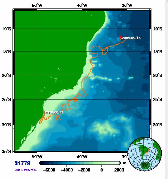
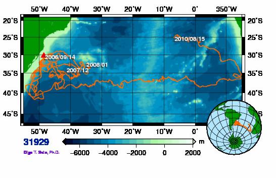
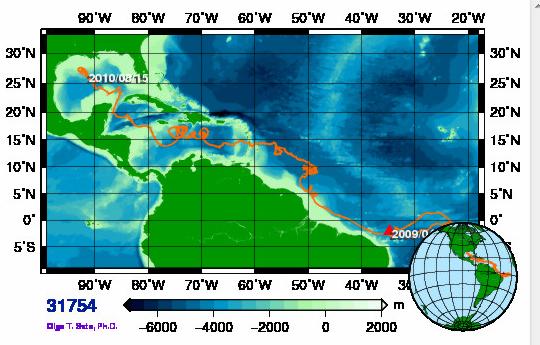
Remote Sensing of the SW South Atlantic Using Satellite Tracked Drifters and AVHRR images
 Remote Sensing of the SW South Atlantic Using Satellite Tracked Drifters and AVHRR images JOÃO A. LORENZZETTI 1 MILTON KAMPEL 1 1 INPE--Instituto Nacional de Pesquisas Espaciais Caixa Postal 515, 12201-097
Meteorology of Monteverde, Costa Rica 2007
 Meteorology of Monteverde, Costa Rica 2007 Technical Report submitted to the Monteverde Institute Andrew J. Guswa, Associate Professor, Picker Engineering Program Amy L. Rhodes, Associate Professor, Department
RR10106 Cruise Plan ITOP Mooring Recovery and PhilSea10 Seaglider Operation (R/V Revelle November 6-26, 2010)
") RR10106 Cruise Plan ITOP Mooring Recovery and PhilSea10 Seaglider Operation (R/V Revelle November 6-26, 2010) Chief Scientist: Ren-Chieh Lien, Applied Physics Lab, University of Washington Co-Chief Scientist:
RR10106 Cruise Plan ITOP Mooring Recovery and PhilSea10 Seaglider Operation (R/V Revelle November 6-26, 2010) Chief Scientist: Ren-Chieh Lien, Applied Physics Lab, University of Washington Co-Chief Scientist:
3. EXCEL FORMULAS & TABLES
 Winter 2017 CS130 - Excel Formulas & Tables 1 3. EXCEL FORMULAS & TABLES Winter 2017 Winter 2017 CS130 - Excel Formulas & Tables 2 Cell References Absolute reference - refer to cells by their fixed position.
SATELLITE TELEMETRY OF TIDAL DATA IN THE HYDROGRAPHIC SERVICE OF THE ROYAL AUSTRALIAN NAVY
 SATELLITE TELEMETRY OF TIDAL DATA IN THE HYDROGRAPHIC SERVICE OF THE ROYAL AUSTRALIAN NAVY by Bohdan PILLICH 1 Abstract The Hydrographic Service of the Royal Australian Navy (RAN) is responsible for charting
SEMDAC MSC support and surveillance in Chile s EEZ, Desventuradas Islands and Easter Island. Laura Fontan Bouzas Fisheries Analyst, OceanMind
 SEMDAC MSC support and surveillance in Chile s EEZ, Desventuradas Islands and Easter Island Laura Fontan Bouzas Fisheries Analyst, OceanMind INTRODUCTION Established in 2015 Supports fisheries Monitoring,
Mooring Modifications for the Reduction of Losses to Vandalism
 Mooring Modifications for the Reduction of Losses to Vandalism H. Paul Freitag Chris Meinig Andrew J. Shepherd Pacific Marine Environmental Laboratory Seattle, Washington, USA Linda D. Stratton JISAO/University
Deep-Arvor: a CTD & DO profiling float for Argo
 Deep-Arvor: a CTD & DO profiling float for Argo Dr Emina Mamaca on behalf of S. LE RESTE, V. DUTREUIL, X. ANDRE, C. TRAUTMANN, T. BESCOND, AST-14, Wellington, New Zealand The first prototype of Deep-Arvor
Annex 2 List of Accredited Programs and Course, by Course
 Annex 2 List of Accredited Programs and Course, by Course Course Accredited Area Name Of Institution Tel Expiry Date Able Seafarer Deck Cape Town SAMTRA (021) 786 8422 06-Dec-18 STC-SA (Pty) Ltd (021)
Wave climate in the Baltic Sea 2014
 Wave climate in the Baltic Sea 2014 Authors: Heidi Pettersson, Marine Research, Finnish Meteorological Institute Helma Lindow, Swedish Meteorological and Hydrological Institute Thorger Brüning, Bundesamt
CMORE HOE DYLAN October 2012 Draft cruise plan
 CMORE HOE DYLAN 11 1 4 October 2012 Draft cruise plan Cruise ID: KM12-21 Vessel: R/V KILO MOANA University of Hawaii Master of the Vessel: Captain Gray Drewry Chief Scientist: Tara Clemente (UH) OTG Marine
Wave climate in the Baltic Sea 2013
 Wave climate in the Baltic Sea 2013 Authors: Heidi Pettersson, Marine Research, Finnish Meteorological Institute Helma Lindow, Swedish Meteorological and Hydrological Institute Thorger Brüning, Bundesamt
Case in traffic engineering and safety. Helena Beatriz Bettella Cybis Universidade Federal do Rio Grande do Sul
 Case in traffic engineering and safety Helena Beatriz Bettella Cybis Universidade Federal do Rio Grande do Sul Helena Beatriz Bettella Cybis PhD in Transport Engineering (ITS University of Leeds UK, 1993)
The Icelandic Information System on Weather and Sea State Related to Fishing Vessels Crews and Stability
 The Icelandic Information System on Weather and Sea State Related to Fishing Vessels Crews and Stability Seminar on Fishing Vessels Crews and Stability World Fishing Exhibition 2009, Vigo Spain September
NEW DEVELOPMENTS IN THE DRIFTER TECHNOLOGIES
 NEW DEVELOPMENTS IN THE DRIFTER TECHNOLOGIES Motyzhev S., Lunev E., Tolstosheev A. Marine Hydrophysical Institute / Marlin-Yug Ltd, 2, Kapitanskaya St., Sevastopol, 299011 Sevastopol, Russian Tel./Fax
Applications of Collected Data from Argos Drifter, NOAA Satellite Tracked Buoy in the East Sea
 Applications of Collected Data from Argos Drifter, NOAA Satellite Tracked Buoy in the East Sea Young-Sang Suh (yssuh@nfrdi.re.kr) Ocean Research Team, National Fisheries Research and Development Institute,
January 2018 Sun Mon Tue Wed Thu Fri Sat Week 2 1 New Year's Day
 January 2018 1 New Year's Day 2 3 4 6 Feb 2018 7 8 9 10 11 12 13 14 1 Martin Luther King 16 17 18 e-learning Curriculum Building the Toolbox (0900-1000) 19 20 21 24 2 28 29 30 31 Jan 2018 February 2018
Mode - 2 internal waves: observations in the non-tidal sea. Elizaveta Khimchenko 1, Andrey Serebryany 1,2.
 Mode - 2 internal waves: observations in the non-tidal sea Elizaveta Khimchenko 1, Andrey Serebryany 1,2 1 P. P. Shirshov Institute of Oceanology RAS, Moscow, Russia 2 Space Research Institute RAS, Moscow,
Eastern Equatorial Pacific
 Overview The is the region of open ocean directly south of Mexico and Central America (between approximately 4 o to 16 o N, and 85 o to 105 o W) (Figure 1). Major bathymetric features include Guatemala
Greater Manchester Police Hate Crime and Hate Incident Data 01/04/14 to 31/03/15
 Greater Manchester Police Hate Crime and Hate Incident Data 01/04/14 to 31/03/15 The data within this document is taken from a live database, and there is the potential that the information contained within
Observations of Near-Bottom Currents with Low-Cost SeaHorse Tilt Current Meters
 DISTRIBUTION STATEMENT A. Approved for public release; distribution is unlimited. Observations of Near-Bottom Currents with Low-Cost SeaHorse Tilt Current Meters Vitalii A. Sheremet, Principal Investigator
CHAPTER 8 BUOYAGE 8.1 GENERAL
 145 CHAPTER 8 BUOYAGE 8.1 GENERAL The term `buoyage encompasses all floating structure such as buoys or beacons which are used to orientate mariners and to mark the edges of navigable channels and fairways.
Annex 2 List of Accredited Programs and Course, by Course
 Annex 2 List of Accredited Programs and Course, by Course Course Accredited Area Name Of Institution Tel Expiry Date Able Seafarer Deck Cape Town SAMTRA (021) 788 5429 06 Dec 18 STC SA (Pty) Ltd (021)
Wind Data Verification Report Arriga 50m
 Page 1 of 11 Site Name Site Details 9531 - Arriga 5m Arriga 5m Date/Time of report generation 27/11/212 4:22 PM Site Number 9531 Mast Height 5m Mast Location 32568 E 811256 N Coordinate System UTM 55K
Sound production in mysticetes. Background. Cetacean vocal frequency ranges Dolphins
 Sound production in mysticetes Fish 475 - May 4 2007 Background Cetaceans produce sound in the widest range of frequencies for any Class of animal Subsonic to supersonic and everywhere in between Sound
Robin J. Beaman. School of Earth and Environmental Sciences, James Cook University, Cairns, Qld 4870, Australia.
 Robin J. Beaman School of Earth and Environmental Sciences, James Cook University, Cairns, Qld 4870, Australia. Email: robin.beaman@jcu.edu.au Seminar to SSSI Qld Hydrography Coping with Nature, Brisbane,
Evaluating Extreme Storm Power and Potential Implications to Coastal Infrastructure Damage, Oregon Coast, USA
 Evaluating Extreme Storm Power and Potential Implications to Coastal Infrastructure Damage, Oregon Coast, USA 1.0 INTRODUCTION Heidi P. Moritz, P.E. and Hans R. Moritz, P.E. U. S. Army Corps of Engineers,
WEATHER AND CLIMATE MONITORING AT THE KENYA METEOROLOGICAL DEPARTMENT
 WEATHER AND CLIMATE MONITORING AT THE KENYA METEOROLOGICAL DEPARTMENT By James K. Muhindi Kenya Meteorological Department P.O. Box 30259 00100 Nairobi, Kenya Tel: 254-20-3867880 Mobile: 254-722-697801
HYDROGRAPHIC AND SITE SURVEY REPORT
 HYDROGRAPHIC AND SITE SURVEY REPORT Proposed Pen Site at Dounie, Sound of Jura Prepared for: Kames Fish Farming Ltd Kilmelford Argyll PA34 4XA Tel: +44 (0)1631 720699 TransTech Limited www.transtechltd.com
UNOLS Ship Schedule Kilo Moana. Kilo Moana 2013 Secure - ID #11436 Version #5-1/9/2013
 UNOLS Ship Schedule - 2013 - Kilo Moana Kilo Moana 2013 Secure - ID #11436 Version #5-1/9/2013 Scheduling Contact(s) Robert E. Hunt marsup@soest.hawaii.edu (808) 842-9814 Notes: 1/9/13 Adjusted many cruise
Drifting buoys. Survey as of 13 December 2016 (ECMWF) JMA starts to produce BUFR
 JMA starts to produce BUFR") Drifting buoys For more than 30 years, drifting buoys had been sending their observations ashore thanks to the Argos system, exclusively. Argos data are processed by CLS in Toulouse (France) and in Largo
Drifting buoys For more than 30 years, drifting buoys had been sending their observations ashore thanks to the Argos system, exclusively. Argos data are processed by CLS in Toulouse (France) and in Largo