HISUI Vicarious calibration and Cal/Val activities
|
|
|
- Elaine Stanley
- 5 years ago
- Views:
Transcription
1 HISUI Vicarious calibration and Cal/Val activities Hirokazu YAMAMOTO (GSJ, AIST) Kenta OBATA (GSJ, AIST) Toru KOUYAMA (ITRI, AIST) Satoshi TSUCHIDA (GSJ, AIST)
2 Introduction The Hyperspectral Imager Suite (HISUI) is the Japanese next-generation Earth observation project, and is being devel- oped by Japanese Ministry of Economy, Trade, and Industry (METI). HISUI Calibration Working Group considers the following calibration methods. Onboard Calibration : Calibrated using the calibration device on satellite Vicarious Calibration : Calibrated by simultaneous ground measurement Cross Calibration : Calibrated using other satellite instruments Lunar Calibration (TBD): Calibrated by viewing the moon (stable radiance)*
3 Specifications of HISUI Multispectral Imager and Hyperspectral Imager Parameter Hyperspectral Imager Multispectral Imager Imaging Type Pushbroom Pushbroom Spatial Resolution / Swath 30 m / 30 km 5 m / 90 km Spectral SNR (30% albedo) Bands Range μm µm Resolution nm nm nm nm 200 MTF Dynamic Range Spectral Calibration VNIR : 0.2 nm SWIR :0.625 nm Saturated at 70% alebdo Radiometric Calibration Absolute : ±5%, among bands :±2% Quantization 12 bits Data Compression Lossless (70%) Pointing Cross track : ± 3 N/A

 Lake Lefroy")


4 Vicarious calibration sites for HISUI Alkali Lake (ALL) Railroad Valley (RRV) Lake Lefroy (LLF) Summer in northern hemisphere Summer in southern hemisphere - Collaboration with CSIRO since 2009 We try to increase vicarious calibration frequency using both of northern hemisphere and southern hemisphere.


5 CSIRO set up the CIMEL site, which is known as Aeronet ( station close to Lake Lefroy in 2012, and ground-based atmospheric data can be downloaded from Aeronet since June, 2012.

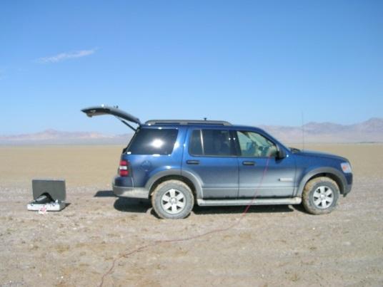
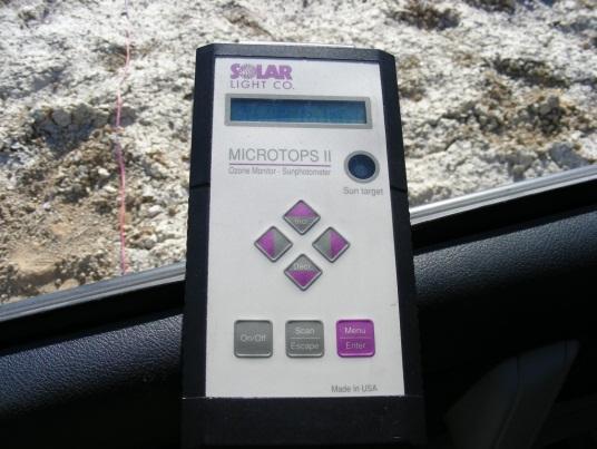
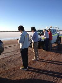
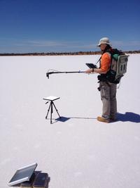
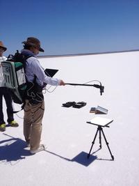
6 Ozonometer Sunphotometer Spectralon Thermo Recorder (Pressure/Temperature) Field Campaign on Nov 26, 2013 (Lake Lefroy, Australia).


7 ASTER image Captured on Nov 26, 2013 Field Campaign on Nov 26, 2013 (Lake Lefroy, Australia).


8 Morning Constellation satellites A view of the Earth with EO-1 above showing instrument swath widths (Pearlman, Carman, and Segal, 2001) RW_EO1%20Papers_Presentations/05.pdf Nov. 26, 2013 : - Field Campaign - Terra ASTER - Landsat-7 ETM+ Dec. 12, 2013 : - EO-1 ALI - EO-1 Hyperion - Landsat-7 ETM+ The EO-1 satellite flies in an orbit that covers the same ground track as Landsat 7, approximately one minute later, and then Terra satellite flies in the same orbit after approximately 30 minutes.

![(http://disc.sci.gsfc.nasa.gov/) (AOT@550[nm]<?](/docs-images/81/82829503/images/9-1.jpg "?) Aeronet (Lake Lefroy (AOT@500[nm] (Ver1.5) : Approx. 0.")

9 MOD08_D3, MISR L3, and AOT on Nov. 26 Lake Lefroy MOD08_D3 generated by NASA Giovanni ( Aeronet (Lake Lefroy (Ver1.5) : Approx ) Lake Lefroy MISR L3 generated by NASA Giovanni ( FC Ground measurement (Nov 26, 2013): AOT@550[nm] = 0.037
10 MOD08_D3 and AOT on Dec. 12 Lake Lefroy MOD08_D3 generated by NASA Giovanni ( :??) MISR L3 product ends on Nov 30, Aeronet (Lake Lefroy) (Ver1.5) : Approx.??)
11 MOD08_D3 and Water Vapor on Nov. 26 MOD08_D3 generated by NASA Giovanni ( (Water Vapor: Approx. 2.0?) FC Ground measurement (Nov 26, 2013) : Water Vapor = 1.24 [cm] Aeronet (Lake Lefroy) (Water Vapor (Ver1.5) : Approx )
 (Water Vapor: Approx. 2.0?) Aeronet (Lake Lefroy) (Water Vapor (Ver1.0) : Approx.??)")
12 MOD08_D3 and Water Vapor on Dec. 12 MOD08_D3 generated by NASA Giovanni ( (Water Vapor: Approx. 2.0?) Aeronet (Lake Lefroy) (Water Vapor (Ver1.0) : Approx.??)
 (Column Amount Ozone: Approx.")

13 Aura OMI L3 Column Amount Ozone on Nov 26 and Dec 12, 2013 Lake Lefroy Lake Lefroy Aura OMI L3 generated by NASA Giovanni ( (Column Amount Ozone: Approx on Nov 26, 2013 FC Ground measurement (Nov 26, 2013) : Ozone = [DU] Aura OMI L3 generated by NASA Giovanni ( (Column Amount Ozone: Approx on Dec 12, 2013
14 Reflectance factors measured at Lake Lefroy on Nov 26, 2013 Surface reflectance factors are derive by using Spectralon white reference panel. We need to evaluate white reference panels we use.
")

15 Spectral Irradiance CEOS recommended solar irradiance spectrum (Thuillier 2002) SUN01kurucz2005 irradiance model is included in MODTRAN5 code [nm] : Thuillier [nm] : SUN01kurucz2005


16 Comparison of TOA radiance We need to evaluate the accuracy around the radiance/reflectance affected by water vapor absorption.

17 Cross-calibration Sensor1 Sensor2 - Radiometric - Wavelength Atmosphere Atmospheric correction BRDF, effects of spatial scaling, Band-to-Band conversion Scattering Absorption We are going to establish the algorithm of cross-calibration for HISUI
 data")

 Δλ = 6-10 nm 0.5 x 0.")
 By using the model, we can")
18 Lunar Reflectance Simulating Model Moon based observations on SELENE/SP (Spectral Profiler) data Reflectance map [Yokota et al., 2011] Geometrical dependencies on incident, emission and phase angles nm (160 channels) Δλ = 6-10 nm 0.5 x 0.5 grid interval 1~2 pixel size of ASTER/VNIR (observing from Earth) By using the model, we can simulate/predict any moon observation. April 13, 2003 April 15 April 18


19 Application of HISUI Calibration parameters GDS (Ground Data System) L0B data for Geo/Cal L0B data for Rad/Cal Geometric Radiometric GCP FC data Other satellite data Geo/Cal (L1) WG Rad/Cal WG Band alignments Pixel alignments GCP check Geometric calibration tables Archives Renewing Every ** months Onboard cal. Vicarious / Cross cal. Lunar cal. Radiometric calibration tables Archives Renewing Every 6 months Reviewing every year?
20 Conclusions EO-1 Hyperion, ALI, Terra ASTER with ground-based data by vicarious calibration experiment is useful as HISUI vicarious calibration and crosscalibration in the pre-launch phase. We continue to evaluate the vicarious calibration and cross-calibration using these satellite sensors. We will develop an algorithm of the cross-calibration for HISUI sensor. We should consider evaluation of obtained reflectance factor around water vapor absorption band for vicarious calibration. White reference panel plays a key role on reflectance approach for vicarious calibration measurement because we use NIST traceable panel. We also plan to understand the characteristics of difference between NIST traceable panel and the white reference panel used in field campaign. HISUI Calibration Working group considers the lunar calibration for HISUI using Lunar Reflectance Model based on SELENE SP data. HISUI Calibration Working group is going to arrange the calibration archive system due to renewing HISUI calibration parameters.


21 Example of averaged surface reflectance factor 2011 Ivanpah Playa Railroad Valley Lake lefroy Lake lefroy
Outline Physical Basis Aerosol Products Validation Algorithm Improvements. AEROCOM Meeting CNES, Paris, June 2-3, 2003
 Aerosol Products from TOMS Omar Torres Joint Center for Earth Systems Technology University of Maryland Baltimore County NASA Goddard Space Flight Center Outline Physical Basis Aerosol Products Validation
High Resolution Sea Surface Roughness and Wind Speed with Space Lidar (CALIPSO)
") High Resolution Sea Surface Roughness and Wind Speed with Space Lidar (CALIPSO) Yongxiang Hu NASA Langley Research Center Carl Weimer Ball Aerospace Corp. 1 CALIPSO Mission Overview CALIPSO seeks to improve
High Resolution Sea Surface Roughness and Wind Speed with Space Lidar (CALIPSO) Yongxiang Hu NASA Langley Research Center Carl Weimer Ball Aerospace Corp. 1 CALIPSO Mission Overview CALIPSO seeks to improve
Bias assessment of MODIS/MISR winds
 Bias assessment of MODIS/MISR winds Feng Lu, Yixuan Shou, Xiaohu Zhang, Jianmin Xu Office of System Development, National Satellite Meteorological Center/CMA 13th International Winds Workshop (IWW13),
A New Method for Suomi-NPP VIIRS Day Night Band (DNB) On-Orbit Radiometric Calibration
 On-Orbit Radiometric Calibration") A New Method for Suomi-NPP VIIRS Day Night Band (DNB) On-Orbit Radiometric Calibration Shihyan Lee, Jeff McIntire, Tom Schwarting and Hassan Oudrari, and Jack Xiong NASA VIIRS Characterization and Support
A New Method for Suomi-NPP VIIRS Day Night Band (DNB) On-Orbit Radiometric Calibration Shihyan Lee, Jeff McIntire, Tom Schwarting and Hassan Oudrari, and Jack Xiong NASA VIIRS Characterization and Support
SWIFT. The Stratospheric Wind Interferometer for Transport Studies
 The Stratospheric Wind Interferometer for Transport Studies SWIFT I. McDade, C. Haley, J. Drummond, K. Strong, B. Solheim, T. Shepherd, Y. Rochon, and the SWIFT Team ESA What is SWIFT? SWIFT is the Stratospheric
Comparative Study of Satellite Images Performance in Mapping Lake Bathymetry: Case Study of Al-Manzala Lake, Egypt
 American Journal of Geographic Information System 2018, 7(3): 82-87 DOI: 10.5923/j.ajgis.20180703.02 Comparative Study of Satellite Images Performance in Mapping Lake Bathymetry: Case Study of Al-Manzala
The Pandonia network for ground validation of satellite-derived trace gas products
 Yonsei University, Seoul The for ground validation of satellite-derived trace gas products Alexander Cede 1,2 and Michel van Roozendael 3 for the Pandora team 1 LuftBlick, 2 NASA/GSFC, 3 BIRA Pandonia
Sentinel-1A Ocean Level-2 Products Validation Strategy
 Sentinel-1A Ocean Level-2 Products Validation Strategy Sentinel-1 Mission Performance Centre ESL L2 Team and Ocean Data Lab G.Hajduch (1), A.Mouche (2), P.Vincent (1), R.Husson (1), H.Johnsen (3), F.Collard
Development of SAR-Derived Ocean Surface Winds at NOAA/NESDIS
 Development of SAR-Derived Ocean Surface Winds at NOAA/NESDIS Pablo Clemente-Colón, William G. Pichel, NOAA/NESDIS Frank M. Monaldo, Donald R. Thompson The Johns Hopkins University Applied Physics Laboratory
ERS-1/2 Scatterometer new products: mission reprocessing and data quality improvement
 ERS-1/2 Scatterometer new products: mission reprocessing and data quality improvement Giovanna De Chiara (1), Raffaele Crapolicchio (1), Pascal Lecomte (2) (1) Serco SpA Via Sciadonna 22-24 Frascati (Roma),
Monetisation of sustainable business models for Satellite Derived Bathymetry
 Monetisation of sustainable business models for Satellite Derived Bathymetry Who are we? We are a UK & UAE based company specialising in satellite derived seabed & environmental mapping products We aim
Inter-comparison of atmospheric correction algorithms over optically-complex waters
 Inter-comparison of atmospheric correction algorithms over optically-complex waters proposed by Cédric Jamet Laboratoire d'océanologie et de Géosciences UMR 8187, ULCO/CNRS 32 avenue Foch 62930 Wimereux,
Boost Your Skills with On-Site Courses Tailored to Your Needs
 Boost Your Skills with On-Site Courses Tailored to Your Needs www.aticourses.com The Applied Technology Institute specializes in training programs for technical professionals. Our courses keep you current
SEA SURFACE TEMPERATURE RETRIEVAL USING TRMM MICROWAVE IMAGER SATELLITE DATA IN THE SOUTH CHINA SEA
 SEA SURFACE TEMPERATURE RETRIEVAL USING TRMM MICROWAVE IMAGER SATELLITE DATA IN THE SOUTH CHINA SEA Mohd Ibrahim Seeni Mohd and Mohd Nadzri Md. Reba Faculty of Geoinformation Science and Engineering Universiti
Status report on the current and future satellite systems by CMA. Presented to CGMS45-CMA-WP-01, Plenary session, agenda item D.1
 Status report on the current and future satellite systems by CMA Presented to CGMS45-CMA-WP-01, Plenary session, agenda item D.1 Overview - Planning of CMA satellite systems FengYun Meteorological Satellites
ERS WAVE MISSION REPROCESSING- QC SUPPORT ENVISAT MISSION EXTENSION SUPPORT
 REPORT 8/2011 ISBN 978-82-7492-248-8 ISSN 1890-5218 ERS WAVE MISSION REPROCESSING- QC SUPPORT ENVISAT MISSION EXTENSION SUPPORT - Annual Report 2010 Author (s): Harald Johnsen (Norut), Fabrice Collard
CENTER FOR SUBSURFACE SENSING AND IMAGING SYSTEMS
 CENTER FOR SUBSURFACE SENSING AND IMAGING SYSTEMS S4: Coral Reef Monitoring Why Coral Reefs? Roy A. Armstrong UPRM CenSSIS Site Visit April 5, 2006 The Importance of Coral Reefs Coral reefs are highly
MISR CMVs. Roger Davies and Aaron Herber Physics Department
 MISR CMVs Roger Davies and Aaron Herber Physics Department Acknowledgements: MISR Science and Data Processing Team (especially Catherine Moroney and Mike Garay) From the AGU Fall Meeting 2009 MISR and
Application of Analytical Algorithm to Classify Near Shore Substrate Types and Coral Reef Environment.
 Application of Analytical Algorithm to Classify Near Shore Substrate Types and Coral Reef Environment. A.K.Mishra, Rahul K. Pandey and A. Mukhopadhya *Marine Science Division, Indian Institute of Remote
Digital Elevation Models
 Digital Elevation Models National Elevation Dataset 14-Oct-14 GEO327G/386G, UT Austin 1 Data Sets US DEM series 7.5, 30, 1 o for conterminous US 7.5, 15 for Alaska US National Elevation Data (NED) GTOPO30
Assimilation of EOS Aura ozone data at the Global Modeling and Assimilation Office
 Assimilation of EOS Aura ozone data at the Global Modeling and Assimilation Office Kris Wargan, I. Stajner, L.-P. Chang, H. Hayashi, S. Pawson, L. Froidevaux, N. Livesey, and P. K. Bhartia Topics Assimilating
Airborne Remote Sensing of Surface and Internal Wave Processes on the Inner Shelf
 Airborne Remote Sensing of Surface and Internal Wave Processes on the Inner Shelf Ken Melville, Luc Lenain Scripps Institution of Oceanography North Wind/Wave NDBC Station 42040 29.212 N 88.207 W 19 Oct
SCOPE OF ACCREDITATION TO ISO/IEC 17025:2017 ANSI/NCSL Z
 SCOPE OF ACCREDITATION TO ISO/IEC 17025:2017 ANSI/NCSL Z540-1-1994 ISO-CAL NORTH AMERICA 36610 N 20 th Street Phoenix, AZ 85086 Erik Naranen Phone: 480 336 8133 Fax: 480 336 8737 enaranen@isocalnorthamerica.com
Thermo Scientific Model 146i Principle of Operation
 Thermo Scientific Model 146i Principle of Operation The Model 146i Multi-gas Calibrator dilutes calibration gases to precise concentrations. The diluted gases are used to perform zero, precision and Level
Intersatellite Calibrated HIRS Upper Tropospheric Water Vapor
 Intersatellite Calibrated HIRS Upper Tropospheric Water Vapor Lei Shi and John J. Bates NOAA National Climatic Data Center Asheville, North Carolina, U.S.A. 1 NOAA National Climatic Data Center ITSC-XVI
Emission Inventory Evaluation Using DISCOVER-AQ Aircraft Data
 Emission Inventory Evaluation Using DISCOVER-AQ Aircraft Data Gary McGaughey, David Allen (PI) and Elena McDonald-Buller (co-pi) Center for Energy and Environmental Resources The University of Texas at
University of Wisconsin SSEC Atmospheric SIPS and AHI/ABI Capabilities
 University of Wisconsin SSEC Atmospheric SIPS and AHI/ABI Capabilities Robert Holz 1, Min Oo 1, Liam Gumley 1, Steve Dutcher 1, Bruce Flynn 1, Greg Quinn 1, Andi Walther 2, Andy Heidinger 2, Jeremy Solbrig
CHANGE OF THE BRIGHTNESS TEMPERATURE IN THE MICROWAVE REGION DUE TO THE RELATIVE WIND DIRECTION
 JP4.12 CHANGE OF THE BRIGHTNESS TEMPERATURE IN THE MICROWAVE REGION DUE TO THE RELATIVE WIND DIRECTION Masanori Konda* Department of Geophysics, Graduate School of Science, Kyoto University, Japan Akira
Walker Circulation and El Niño / La Niña Sea Surface Temperature, Rainfall, and Zonal Wind
 Walker Circulation and El Niño / La Niña Sea Surface Temperature, Rainfall, and Zonal Wind David Halpern NASA / California Institute of Technology Jet Propulsion Laboratory Pasadena, CA 91109, USA Contents
Small Footprint Topo-Bathymetric LiDAR
 May 8, 2013 Small Footprint Topo-Bathymetric LiDAR PNAMP Remote Sensing Forum Russ Faux, Co-CEO, WSI Amar Nayegandhi, Manager of Elevation Technologies, Dewberry Colin Cooper, Senior Analyst, WSI Watershed
Appendix 5: Currents in Minas Basin. (Oceans Ltd. 2009)
") Appendix 5: Currents in Minas Basin (Oceans Ltd. 29) Current in Minas Basin May 1, 28 March 29, 29 Submitted To: Minas Basin Pulp and Power P.O. Box 41 53 Prince Street Hansport, NS, BP 1P by 22, Purdy
Appendix 5: Currents in Minas Basin (Oceans Ltd. 29) Current in Minas Basin May 1, 28 March 29, 29 Submitted To: Minas Basin Pulp and Power P.O. Box 41 53 Prince Street Hansport, NS, BP 1P by 22, Purdy
Improve Process Reliability
 Convenient Conductivity Calibration to Meet Pharmacopeia Regulations Pharmacopeias require that conductivity measurement systems be periodically calibrated to ensure their precision. The range of accessories
An Atlas of Oceanic Internal Solitary Waves (February 2004) by Global Ocean Associates Prepared for Office of Naval Research Code 322 PO
 by Global Ocean Associates Prepared for Office of Naval Research Code 322 PO") Overview covers approximately 5500 km of coast between Western Sahara (22 o N, 17 o W) and Angola (5 o S, 12 o E) (Figure 1). The continental shelf in the region varies significantly in width. The region
Overview covers approximately 5500 km of coast between Western Sahara (22 o N, 17 o W) and Angola (5 o S, 12 o E) (Figure 1). The continental shelf in the region varies significantly in width. The region
Underwater measurement of photosynthetically active radiation
 Underwater measurement of photosynthetically active radiation Mark Blonquist, Damon Nitzel, and Bruce Bugbee Apogee Instruments, Inc., Logan, Utah Introduction Quantum sensors (photosynthetically active
Earth and Planetary Sciences 5 Midterm Exam March 10, 2010
 Earth and Planetary Sciences 5 Midterm Exam March 10, 2010 Name: Teaching Fellow: INSTRUCTIONS PUT YOUR NAME ON EACH PAGE. The exam will last 80 minutes. Complete the problems directly on the exam. Extra
THE POLARIMETRIC CHARACTERISTICS OF BOTTOM TOPOGRAPHY RELATED FEATURES ON SAR IMAGES
 THE POLARIMETRIC CHARACTERISTICS OF BOTTOM TOPOGRAPHY RELATED FEATURES ON SAR IMAGES Taerim Kim Professor, Ocean System Eng. Dept. Kunsan University Miryong Dong San 68, Kunsan, Jeonbuk, Korea, trkim@kunsan.ac.kr
MIKE 21 Toolbox. Global Tide Model Tidal prediction
 MIKE 21 Toolbox Global Tide Model Tidal prediction MIKE Powered by DHI 2017 DHI headquarters Agern Allé 5 DK-2970 Hørsholm Denmark +45 4516 9200 Telephone +45 4516 9333 Support +45 4516 9292 Telefax mike@dhigroup.com
Measuring Ultraviolet Radiation Underwater: A Practical. Application of the Beer-Lambert-Bouguer Law for High School. Physics
 Measuring Ultraviolet Radiation Underwater: A Practical Application of the Beer-Lambert-Bouguer Law for High School Physics INTRODUCTION The precise measurement of solar UV on the surface of the Earth
TRMM TMI and AMSR-E Microwave SSTs
 TMI and AMSR-E Microwave SSTs Chelle Gentemann, Frank Wentz, & Peter Ashcroft Gentemann@remss.com www.remss.com TMI/AMSR-E MW SST algorithm development Validation Results Sensor Issues Useful for Climate
STUDY OF LOCAL WINDS IN MOUNTAINOUS COASTAL AREAS BY MULTI- SENSOR SATELLITE DATA
 STUDY OF LOCAL WINDS IN MOUNTAINOUS COASTAL AREAS BY MULTI- SENSOR SATELLITE DATA Werner Alpers Institute of Oceanography, University of Hamburg, Bundesstrasse 53, D-20146 Hamburg, Germany E-mail: alpers@ifm.uni-hamburg.de
Stadium Project - DP-70 Atlanta, GA, 9/30/2014
 Page 1 of 13 The enclosed report contains the data and analysis summary for the SoniCaliper shaft caliper, performed at Stadium Project (DP-70), Atlanta, GA on Tuesday, September 30, 2014 by Chris Kohlhof.
MATRIX-MG Series. Innovation with Integrity. Automated High-Performance Gas Analyzers FT-IR
 MATRIX-MG Series Automated High-Performance Gas Analyzers Innovation with Integrity FT-IR The MATRIX-MG Series comprises three high-performance FT-IR gas analyzers in a compact and rugged housing. They
Water Level Fluctuations of Lake Enriquillo and Lake Saumatre in Response to Environmental Changes
 Water Level Fluctuations of Lake Enriquillo and Lake Saumatre in Response to Environmental Changes A Masters of Engineering Project Presented to the Faculty of the Graduate School of Cornell University
Depth analysis of Midway Atoll using Quickbird multi-spectral imaging over variable substrates
 Calhoun: The NPS Institutional Archive DSpace Repository Theses and Dissertations 1. Thesis and Dissertation Collection, all items 2006-09 Depth analysis of Midway Atoll using Quickbird multi-spectral
Development, Validation, and Fusion of High Resolution Active and Passive Optical Imagery
 Development, Validation, and Fusion of High Resolution Active and Passive Optical Imagery W. Paul Bissett 1, Sharon DeBra 1, Mubin Kadiwala 1, David D. R. Kohler 1, Curtis Mobley 2, Robert G. Steward 1,
Mid-IR Lasers Market Review and Forecast 2010
 Mid-IR Market Review and Forecast 2010 Report OM-56 September 2010 Strategies Unlimited 201 San Antonio Circle, Suite 225 Mountain View, California 94040 Phone: (650) 941-3438 Fax: (650) 941-5120 e-mail:
SUPPLEMENTARY INFORMATION
 SUPPLEMENTARY INFORMATION Spatially variable response of Himalayan glaciers to climate change affected by debris cover Dirk Scherler 1 *, Bodo Bookhagen 2, Manfred R. Strecker 1 1 Institute of Earth and
Preparation of the ADM-Aeolus mission using 355nm high spectral resolution Doppler LIDAR and a Doppler cloud radar
 Preparation of the ADM-Aeolus mission using 355nm high spectral resolution Doppler LIDAR and a Doppler cloud radar Abdanour Irbah*, Jacques Pelon*, Julien Delanoë*, Gwendal Rivière +, Didier Bruneau*,
Confidence through traceability
 Confidence through traceability 1 st November 2016 The Institute of Engineering and Technology Dr Peter Thompson, NPL CEO Alan Turing s Pilot ACE Dr Peter Thompson, NPL CEO NPL Miniature Atomic Clock World
SPIRIT III Radiometer Saturation Effect
 Utah State University DigitalCommons@USU Space Dynamics Lab Publications Space Dynamics Lab 1-1-1997 SPIRIT III Radiometer Saturation Effect Joseph J. Tansock Follow this and additional works at: https://digitalcommons.usu.edu/sdl_pubs
Cross-Calibrating OSCAT Land Sigma-0 to Extend the QuikSCAT Land Sigma-0 Climate Record
 Cross-Calibrating OSCAT Land Sigma-0 to Extend the QuikSCAT Land Sigma-0 Climate Record David G. Long Department of Electrical and Computer Engineering Brigham Young University May 2013 0 Scatterometer
Update of the COST726 Total Ozone Data Base up to December 31, 2008
 Update of the COST726 Total Ozone Data Base up to December 31, 2008 Janusz W. Krzyścin Institute of Geophysics Polish Academy of Sciences COST 726 Final Seminar; 13-14.05.2009, Warsaw, Poland TOTAL OZONE
SENSOR SYNERGY OF ACTIVE AND PASSIVE MICROWAVE INSTRUMENTS FOR OBSERVATIONS OF MARINE SURFACE WINDS
 SENSOR SYNERGY OF ACTIVE AND PASSIVE MICROWAVE INSTRUMENTS FOR OBSERVATIONS OF MARINE SURFACE WINDS N. Ebuchi Institute of Low Temperature Science, Hokkaido University, N19-W8, Kita-ku, Sapporo 060-0819,
Satellite-Derived Bathymetry Modelling in Shallow Water: A Case Study of Lighthouse Creek, Lagos
 Satellite-Derived Bathymetry Modelling in Shallow Water: A Case Study of Lighthouse Creek, Lagos This is a Peer Reviewed Paper Dupe N. OLAYINKA and Chukwuma J. OKOLIE, Nigeria Keywords: Bathymetry, Satellite-Derived
Global Structure of Brunt Vaisala Frequency as revealed by COSMIC GPS Radio Occultation
 ICGPSRO, May 14-16, 2013, Taiwan Session 3A; U3-2B-208-05 14:10-14:25, May 14 Global Structure of Brunt Vaisala Frequency as revealed by COSMIC GPS Radio Occultation Noersomadi National Institute of Aeronautics
Annual Measurement of Solar UVB at a Reef Site Using a Polyphenylene Oxide Dosimeter
 Annual Measurement of Solar UVB at a Reef Site Using a Polyphenylene Oxide Dosimeter Alfio Parisi, Nathan Downs, Peter Schouten parisi@usq.edu.au University of Southern Queensland, Toowoomba, Australia
Monitoring Water Transparency and Diver Visibility in Ports and Harbors Using Aircraft Hyperspectral Remote Sensing
 Monitoring Water Transparency and Diver Visibility in Ports and Harbors Using Aircraft Hyperspectral Remote Sensing CharlesC. Trees*a, Paul W. Bissettb,Heidi Dierssenc, David D. R. Kohlerb,Mark A. Molined,
Contribution of French research teams to ADM Cal/Val
 Contribution of French research teams to ADM Cal/Val A. Dabas, Météo-France J.P. Cammas (OSUR), P. Chazette (LSCE), A. Hauchecorne (LATMOS), A. Hertzog (LMD), F. Gibert (LMD), J. Pelon (LATMOS) ESA UNCLASSIFIED
The Importance of Mina site within Mecca urban cover change between 1998 and 2013
 FINAL INTERNSHIP REPORT Internship in Urban Remote Sensing Period: February through May 2015 Company: Starlab Ltd, UK The Importance of site within Mecca urban cover change between 1998 and 2013 Author
RIVET Satellite Remote Sensing and Small Scale Wave Process Analysis
 DISTRIBUTION STATEMENT A. Approved for public release; distribution is unlimited. RIVET Satellite Remote Sensing and Small Scale Wave Process Analysis Hans C. Graber RSMAS Department of Ocean Sciences
SIMON YUEH, WENQING TANG, ALEXANDER FORE, AND JULIAN CHAUBELL JPL-CALTECH, PASADENA, CA, USA GARY LAGERLOEF EARTH AND SPACE RESEARCH, SEATTLE, WA, US
 Applications of L-Band Scatterometry and Radiometry to Aquarius and SMAP SIMON YUEH, WENQING TANG, ALEXANDER FORE, AND JULIAN CHAUBELL JPL-CALTECH, PASADENA, CA, USA GARY LAGERLOEF EARTH AND SPACE RESEARCH,
Wave-Phase-Resolved Air-Sea Interaction
 DISTRIBUTION STATEMENT A. Approved for public release; distribution is unlimited. Wave-Phase-Resolved Air-Sea Interaction W. Kendall Melville Scripps Institution of Oceanography (SIO) UC San Diego La Jolla,
The Influence of Breaking at the Ocean Surface on Oceanic Radiance and Imaging
 The Influence of Breaking at the Ocean Surface on Oceanic Radiance and Imaging W. Kendall Melville Scripps Institution of Oceanography, University of California, San Diego 9500 Gilman Drive La Jolla, CA
Vaisala Pressure, RH & Temp. Transmitter. The instrument was operational upon receipt. The instrument was adjusted and calibrated.
 Asset #: 123 Calibration - Certificate No: 2083.01 Customer: Condition: Action Taken: Sample Inc. 123 Sample Rd. Sample, MA 01234 The instrument was operational upon receipt. The instrument was adjusted
J4.2 AUTOMATED DETECTION OF GAP WIND AND OCEAN UPWELLING EVENTS IN CENTRAL AMERICAN GULF REGIONS
 J4.2 AUTOMATED DETECTION OF GAP WIND AND OCEAN UPWELLING EVENTS IN CENTRAL AMERICAN GULF REGIONS Xiang Li*, University of Alabama in Huntsville Huntsville, AL D. K. Smith Remote Sensing Systems Santa Rosa,
CEE 452/652. Week 3, Lecture 1 Mass emission rate, Atmospheric Stability. Dr. Dave DuBois Division of Atmospheric Sciences, Desert Research Institute
 CEE 452/652 Week 3, Lecture 1 Mass emission rate, Atmospheric Stability Dr. Dave DuBois Division of Atmospheric Sciences, Desert Research Institute Today s topics Review homework Review quiz Mass emission
Central American Pacific Coast
 Overview The Pacific coast of Central America extends approximately 3700 km from central Mexico (20 o N, 106 o W) to the edge of South America (7 o N, 78 o W). A significant continental shelf exists from
Open Ocean Storm Waves in the Arctic
 International Workshop on Wave Hindcasting and Forecasting/Coastal Hazards Symposium Liverpool, UK, 10-15 September 2017 Open Ocean Storm Waves in the Arctic Takuji Waseda,Adrean Webb (UTokyo, Japan) Kazutoshi
Robin J. Beaman. School of Earth and Environmental Sciences, James Cook University, Cairns, Qld 4870, Australia.
 Robin J. Beaman School of Earth and Environmental Sciences, James Cook University, Cairns, Qld 4870, Australia. Email: robin.beaman@jcu.edu.au Seminar to SSSI Qld Hydrography Coping with Nature, Brisbane,
High resolution wind retrieval for SeaWinds
 High resolution wind retrieval for SeaWinds David G. Long and Jeremy B. Luke Brigham Young University, 459 Clyde Building, Provo, UT 84602, USA ABSTRACT The SeaWinds instrument on the QuikSCAT satellite
Lifting satellite winds from 10 m to hub-height
 Lifting satellite winds from 10 m to hub-height Hasager, C.B., Badger, M., Peña, A., Hahmann, A., Volker, P. 23 May 2016 VindkraftNet meeting, DONG Energy, Skærbæk Motivation We have: Satellite wind maps
JCOMM Technical Workshop on Wave Measurements from Buoys
 JCOMM Technical Workshop on Wave Measurements from Buoys Val Swail Chair, JCOMM Expert Team on Wind Waves and Storm Surges Neville Smith Vincent Cardone Peter Janssen Gerbrand Komen Peter Taylor WIND WAVES
Projection Lens Datasheet
 Projection Lens Datasheet Projection Options Global Laser are able to offer a wide range of diffractive optical elements (DOE) to provide various patterns such as crosses, circles & dot arrays for applications
Section 1. Global Wind Patterns and Weather. What Do You See? Think About It. Investigate. Learning Outcomes
 Chapter 5 Winds, Oceans, Weather, and Climate Section 1 Global Wind Patterns and Weather What Do You See? Learning Outcomes In this section, you will Determine the effects of Earth s rotation and the uneven
An algorithm for Sea Surface Wind Speed from MWR
 An algorithm for Sea Surface Wind Speed from MWR Carolina Tauro 1, Yazan Heyazin 2, María Marta Jacob 1, Linwood Jones 1 1 Comisión Nacional de Actividades Espaciales (CONAE) 2 Central Florida Remote Sensing
Axial Base (PN3A) Medium-Power (MP) J-box
 Medium-Power (MP) J-box") Axial Base (PN3A) Medium-Power (MP) J-box Location: 46.1 N, 129.6 W Depth of Water Column: 2654 m This node supports geophysical instruments at the base of Axial Seamount. Instrument Name/Description Data
Axial Base (PN3A) Medium-Power (MP) J-box Location: 46.1 N, 129.6 W Depth of Water Column: 2654 m This node supports geophysical instruments at the base of Axial Seamount. Instrument Name/Description Data
SEASONDE DETECTION OF TSUNAMI WAVES
 SEASONDE DETECTION OF TSUNAMI WAVES Belinda Lipa, John Bourg, Jimmy Isaacson, Don Barrick, and Laura Pederson 1 I. INTRODUCTION We here report on preliminary results of a study to assess the capability
Freeboard changes of Drygalski and Mertz ice tongues in east Antarctica using altimetry data
 Freeboard changes of Drygalski and Mertz ice tongues in east Antarctica using altimetry data XIANWEI WANG 1 and DAVID M. HOLLAND 1, 2 1. Center for Global Sea Level Change, New York University Abu Dhabi.
Exercise: Satellite Imagery Analysis. 29 June 2016 Japan Meteorological Agency
 Exercise: Satellite Imagery Analysis 29 June 2016 Japan Meteorological Agency Contents 1. Fog/Stratiform Cloud 2. Cb (Cumulonimbus)/Cg (Cumulus congestus) 3. Upper-level Flow Jet stream, upper trough,
The RSS WindSat Version 7 All-Weather Wind Vector Product
 2010 International Ocean Vector Winds Meeting Barcelona, Spain May 18 20, 2010 The RSS WindSat Version 7 All-Weather Wind Vector Product Thomas Meissner Lucrezia Ricciardulli Frank Wentz Outline 1. Overview:
PRELIMINARY STUDY ON DEVELOPING AN L-BAND WIND RETRIEVAL MODEL FUNCTION USING ALOS/PALSAR
 PRELIMINARY STUDY ON DEVELOPING AN L-BAND WIND RETRIEVAL MODEL FUNCTION USING ALOS/PALSAR Osamu Isoguchi, Masanobu Shimada Earth Observation Research Center, Japan Aerospace Exploration Agency (JAXA) 2-1-1
Singapore Mosaic PRODUCT SPECIFICATIONS
 Singapore Mosaic PLANET BASEMAPS PRODUCT SPECIFICATIONS PLANET.COM MAY 2018 TABLE OF CONTENTS GLOSSARY 4 1. OVERVIEW OF PLANET BASEMAPS 5 2. AUTOMATED TIMELAPSE BASEMAPS PRODUCT SPECIFICATIONS 6 2.1 RANGE
Water Level Fluctuations of Lake Enriquillo and Lake Saumatre in Response to Environmental Changes
 Water Level Fluctuations of Lake Enriquillo and Lake Saumatre in Response to Environmental Changes A Masters of Engineering Project Presented to the Faculty of the Graduate School of Cornell University
Validation of long-range scanning lidars deployed around the Høvsøre Test Station
 Downloaded from orbit.dtu.dk on: Dec 18, 2017 Validation of long-range scanning lidars deployed around the Høvsøre Test Station Lea, Guillaume; Courtney, Michael Publication date: 2016 Link back to DTU
Orbiter* Architecting Software Across International Partnerships. Jason LaPointe December 10 th, 2010
 ExoMars/Trace Gas Orbiter* Architecting Software Across International Partnerships Jason LaPointe December 10 th, 2010 Jet Propulsion Laboratory California Institute of Technology Pasadena, CA 2010 Workshop
Hyperspectral Optical Properties, Remote Sensing, and Underwater Visibility
 Hyperspectral Optical Properties, Remote Sensing, and Underwater Visibility Robert A. Maffione Hydro-Optics, Biology, and Instrumentation Laboratories P.O. Box 859 Moss Landing, California 95039 Phone:
Online gas monitoring by using Raman spectroscopy
 NEXTLAB Conference, 2-4 April 2014 Online gas monitoring by using Raman spectroscopy Yamina OUABBAS H. Lucas 2, J. P. Viricelle 1, S. Grimaldi 3, B. Allard-Breton 3 1 Ecole Nationale Supérieure des Mines,
Monitoring tidal movements in Cook Inlet, Alaska, using the integration of remote sensing data, GIS, and inundation models
 Monitoring tidal movements in Cook Inlet, Alaska, using the integration of remote sensing data, GIS, and inundation models Hua Liu Department of political Science and Geography Old Dominion University
Alphasense Application Note AAN NDIR: Gas Concentration Calculation Overview
 AAN 21-6 NDIR: Gas Concentration Calculation Overview 1. What is an NDIR Sensor? Alphasense IRC-A sensors use the principle of Non-Dispersive Infra-Red (NDIR to determine gas concentration. Each sensor
Wind Atlas for the Gulf of Suez Satellite Imagery and Analyses
 Downloaded from orbit.dtu.dk on: Nov 09, 2017 Wind Atlas for the Gulf of Suez Satellite Imagery and Analyses Hasager, Charlotte Bay Publication date: 2003 Document Version Publisher's PDF, also known as
The Wind Resource: Prospecting for Good Sites
 The Wind Resource: Prospecting for Good Sites Bruce Bailey, President AWS Truewind, LLC 255 Fuller Road Albany, NY 12203 bbailey@awstruewind.com Talk Topics Causes of Wind Resource Impacts on Project Viability
MOTUS Wave Buoys. Powered By the Aanderaa MOTUS Directional Wave Sensor
 MOTUS Wave Buoys Powered By the Aanderaa MOTUS Directional Wave Sensor Two Buoys, One Brain The Aanderaa MOTUS directional wave sensor factory calibrated and currently available on two proven buoy platforms:
Landsat 8's Emergency RMM
 Landsat 8's Emergency RMM A Quick-Turnaround Method Bob Scheid Landsat 8 Flight Operations KBRwyle Goddard Space Flight Center, MD November 5, 2016 Agenda Brief overview of Landsat s mission and command
Using Satellite Spectral Wave Data for Wave Energy Resource Characterization
 Using Satellite Spectral Wave Data for Wave Energy Resource Characterization M. T. ontes 1,2, M. Bruck 3, S. Lehener 3, A. Kabuth 1,4 1 LNEG Estrada do aço do Lumiar 1649-038 Lisboa, ortugal teresa.pontes@lneg.pt
Tsunamis are not observed via height rather by orbital velocity from shallow-water wave physics
 Modeling of Tsunami Current Flows Presenter: Dr. Don Barrick President, CODAR Ocean Sensors Coauthors: Dr. Belinda Lipa, Chad Whelan RIAM Workshop on Oceanographic Radar Tsunami capability of HF radar
The Wave Glider: A Mobile Buoy Concept for Ocean Science. 009 Liquid Robotics Inc.
 The Wave Glider: A Mobile Buoy Concept for Ocean Science 009 Liquid Robotics Inc. J. Manley & T. Richardson: Liquid Robotics Inc. DBCP XXV Paris September 28, 2009 1 Wave Glider Overview Unique Two Part
GNSS Technology for the Determination of Real-Time Tidal Information
 GNSS Technology for the Determination of Real-Time Tidal Information Benjamin Kidder C-Nav Positioning Solutions European region Outline of Topics Covered Introduction to Tides Past and Present Methods
MOUNTAIN WAVES IN THE MIDDLE ATMOSPHERE: MICROWAVE LIMB SOUNDER OBSERVATIONS AND ANALYSES
 Pergamon www.elsevier.com/locate/asr doi: lo.l016/s0273-1177(03)00402-2 Available online at www.sciencedirect.com SCIENCE DIRECT MOUNTAIN WAVES IN THE MIDDLE ATMOSPHERE: MICROWAVE LIMB SOUNDER OBSERVATIONS
ENVISAT WIND AND WAVE PRODUCTS: MONITORING, VALIDATION AND ASSIMILATION
 ENVISAT WIND AND WAVE PRODUCTS: MONITORING, VALIDATION AND ASSIMILATION Peter A.E.M. Janssen (), Saleh Abdalla (), Jean-Raymond Bidlot (3) European Centre for Medium-Range Weather Forecasts, Shinfield
Uncertainty Estimates in Satellite Derived Bathymetry
 Uncertainty Estimates in Satellite Derived Bathymetry Richard Flemmings, TCarta #chcnsc2018 Introduction and Overview 1. TCarta 2. Satellite Derived Bathymetry Overview 3. Satellite Derived Bathymetry