ENDS OF THE CANAL 83. much as $70,000 a year to keep each one in commission, and the rough places a plain."
|
|
|
- Eugene Clarke
- 5 years ago
- Views:
Transcription


1 ENDS OF THE CANAL 83 As^one travels along the Pacific end of the canal he is reminded of the words of Isaiah: "Every valley shall be exalted, and every mountain and hill shall be made low; and the uneven shall be made level, and the rough places a plain." Hundreds of acres of low, marshy land have been filled up, either with mud from the suction dredges and the hydraulic excavators, or with spoil from Culebra Cut. Much of this made land will be valuable for tropical agriculture, while other parts will never serve any purpose other than to keep down the marshes. But they afforded a dumping ground for material taken out of the canal prism, and added something to the improvement of health and living conditions on the Isthmus. Probably the most interesting process of excavation in the sea-level channels was that of the sea-going suction dredges. These dredges took out material more cheaply than any other kind of excavating machinery used on the Isthmus. Two of them were put to work in 1908, about the time the operations reached full-blast and have been kept in commission ever since. While it cost as much as $70,000 a year to keep each one in commission, they were able to maintain an annual average of about 5,000,000 cubic yards of material excavated at a cost per yard of 5 cents and even less. With steam shovels it ranged from 10 to 20 times as much per yard. These big dredges were built with great bins in their holds and equipped


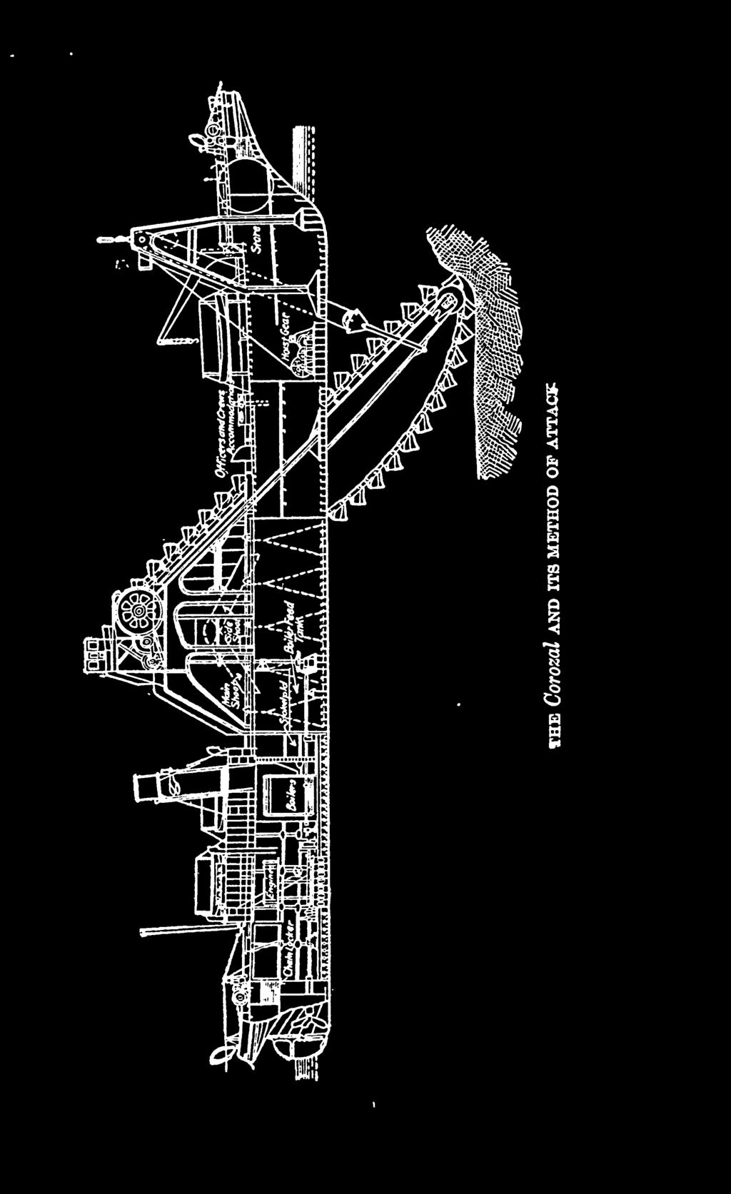
2 84. ^ THE PANAMA CANAL with powerful 20-inch centrifugal pumps. When at work they steamed up and down the channel, sucking up the mud, and carrying it out to sea. Another interesting dredge used was the big ladder dredge Corozal. It is a great floating dock, as it were, with a huge endless chain carrying 52 immense, 35-cubic-foot buckets. On the center line amidships there is a large opening down to the water. The big elevator framework carrying the endless chain goes down through this and into the water at a considerable angle. The buckets pass around this, and as they round the end of it their great steel lips dig down into the material until filled, then they come up at the rate of three every five seconds and deposit their burden in a huge hopper which conveys it to the barge at the side of the dredge. The dredge is anchored fast at a place, and keeps on attacking the material eneath it until the desired level is reached. This fiven dredge, with the sea-going suction dredges, will be retained as the permanent dredging fleet. The stationary suction dredges at the two ends of the canal were used to pump up the soft material and to force it out through long pipe lines into the swamps or into the hydraulic cores of the earth dams. Several old French ladder dredges were rescued from the jungle and put into commission at the beginning of the work, and they held out faithfully to the end, dividing honors with the newer equipment in hastening the day when the oceans might go inland to Gatun and Miraflores. While they looked like toys beside such giant excavators as the Corozal, they probably showed more


3


4 86 THE PANAMA CANAL efficiency than any other class of excavators of their period of construction. They were attended by large self-propelling scows built by the French. When these were filled they steamed out to sea and dumped their burden and then steamed back again for another load. Some of the dredges were attended by ordinary barges which were towed out to sea by tugs and dumped. Another interesting machine used on the Pacific end of the canal was the Lobnitz rock breaker. This consists of a sort of pile driver mounted on a large barge. Instead of a pile driving weight there is a big battering ram made of round steel, pointed at one endo It is lifted up perhaps 10 feet and allowed to drop suddenly. As some of these rams weigh as much as 25 tons their striking force may be imagined. When the ram struck the rock the top would shake back and forth like a bamboo pole, in spite of the fact that it was made of the best steel and more than 15 inches in diameter. Sooner or later the rams would break off at the water line, this being due to the fact that the constant flexion at that point set the molecules in the steel and took away all its elasticity. It was found desirable to excavate a part of the sea-level channel before the water was let into it. To accomplish this a big dam, or dike, was built across the channel several miles inland, and steam shovels were used behind this dike. As the work neared completion, however, it was found advisable to let the water come further inland, so that the dredges could extend the field of their activities. To do this another dike was thrown across the channel about a mile north of the first one,


5 ENDS OF THE CANAL 87 and water was admitted to the section of the big ditch between these two dikes. The engineers were afraid to cut a small ditch in the top of the first dike, and allow the water to eat the dam away as it flowed in, for fear that it would rush in so rapidly it would destroy the second dike. Therefore they filled the basin between the two dikes by siphon and by pumping, a process which required the drawing in of billions of gallons of water. This was accomplished in due time, however, and then 16 tons of dynamite was placed in the no longer useful dike. An electric spark did the rest. The distinguishing features of the ends of the canal are the big breakwaters at Toro Point, at the Atlantic end, and Naos Island, at the Pacific end. The former extends from the shore out into the sea for a distance of 2 miles and has a large lighthouse at the seaward end. It was built by dumping stone from the shore out into the sea, this process being followed by driving piles into the dumped stone and building a railroad on the crest, over which the stone was hauled for its further extension. The top of the breakwater is covered with huge stones weighing from 8 to 20 tons each, these to make sure that it will stand against the pounding of the waves. Two minor breakwaters were also built at the Atlantic end to protect the terminal basin. The big dike at Naos Island in the Pacific is more than 17,000 feet long and transforms the island into the cape of a small peninsula. There was a threefold purpose in its construction to cut out the cross currents that brought thousands


6 88 THE PANAMA CANAL of yards of sand and silt into the canal channel, to afford a dumping place for a large quantity of the spoil from Culebra Cut, and to make a connection with the mainland for the fortifications on Naos, Flamenco, and Perico Islands. In building it the engineers were under the necessity of first building a trestle on which the spoil trains could be backed and dumped. The piles had to be driven in soft, blue mud, and as the rock was dumped, it sank down and down until, at places, ten times as much stone was required as would have been necessary if the ocean bottom had been firm. In addition to this thousands of trainloads of material were dumped in the landward end of the dike, some 20,000,000 cubic yards of material being thus disposed of. The last part of the canal work to be completed will be the terminal facilities at the ends of the big waterway. At the time this book went to press they were something more than a year from completion, but the indications were that they would be finished within the time limit originally set for the completion of the canal itself. These terminal facilities consist of dry docks, wharfage space, storehouses, and everything else necessary to perform any service that might ordinarily be required for passing ships, whether they be those of commerce or of war. The main coaling station is to be established at the Atlantic end. The storehouses, the laundry, the bakery, and the other equipment of the Isthmian Canal Commission and the Panama Railroad also will be made a part of the permanent terminal plant on that side of the Isthmus.


7 ENDS OF THE CANAL 89 A large dry dock is being built at the Pacific end having the same usable dimensions as the canal locks, capable of accommodating any vessel that can pass through the canal. The principal machine shops will also be erected there, and a coaling plant of half the capacity of the one at the Atlantic end will be provided. A little to the east of the Pacific terminal works will be stationed the capital of the Canal Zone, where the administrative offices, the governor's residence, and two new towns will be built. The administration building, which is to be a three-story structure of concrete, hollow tile, and structural steel, is to occupy an eminence on the side of Ancon Hill, which will afford a splendid view of the Pacific fortifications, the entrance to the canal channel, a part of the port works, and of the canal itself from the great continental divide to the Pacific. There one may sit and see ships coming into the canal, tying up at the docks, sailing up the big ditch, and passing through the locks at Miraflores and Pedro Miguel. Near by will be the permanent home of the marines who will be stationed on the Isthmus, their barracks and grounds occupying the broad plateau on the side of Ancon Hill made by taking out the millions of cubic yards of stone required for the concrete works on the Pacific side of the Isthmus. Two permanent towns will be built at Balboa, one for the Americans and the other for the common laborers. The American town will be built under the capitol hill on a broad plain that was made by pumping hydraulic material into a swamp and by dumping spoil from Culebra Cut.


8 90 THE PANAMA CANAL When the terminal plant at Balboa is completed it will represent probably the most extensive and adequate port works in the New World. In addition to the main dry dock it will have a second one which will be smaller, but which will be large enough to accommodate a majority of the ships that will pass through the canal. The existing dry dock at the Atlantic end will be continued in service. It is certain that none of these port works will ever fail by reason of insecure foundations. Wherever unusual loads were to be carried great piers of reinforced concrete were sent down to solid rock, often a distance of 60 feet below the surface. They consisted of a hollow shell of reinforced concrete which was allowed to sink to hardpan of its own accord or under heavy weight. These shells were built in sections 6 feet high. The bottom section was 10 feet in diameter, and the lower end was equipped with a sharp steel shoe. As the section cut down into the earth of its own weight and that above it, laborers on the inside removed the material under the shoe and as they did so it sank further down. The sections above were only 8 feet in diameter, and did not quite fill up the hole made by the bottom of the section, thus overcoming all skin friction, and permitting the full weight of the series of sections to fall on the lower one. A jet of water was forced around the sinking pier all the time it was going down, and this made its progress the more easy. At times the weight of the superimposed sections was sufficient to force the pier down through the soft mud, while at other times the material became so


9 ENDS OF THE CANAL 91 heavy that even a 25-ton weight on top of the pier scarcely moved it. At one place a stratum of material was struck about 25 feet below the surface which yielded sulphuretted hydrogen gas. This affected the laborers' eyes, and some of them had to go to the hospital for treatment. The work of digging out the material was continued until the lower section reached bed rock, where it was anchored. The sections themselves were tied together with heavy iron rods. After they were firmly in place the interior was rilled up with concrete, itself reinforced, so that the foundations became, in reality, a series of huge concrete piles, 8 feet in diameter, anchored to bed rock. The coaling plants at the two terminals will be the crowning features of the terminal facilities. With an immense storage capacity, and with every possible facility for the rapid handling of coal, both in shipping and unshipping it, no other canal in the world will be so well equipped. The coal storage basin at the Atlantic end will hold nearly 300,000 tons. This basin will be built of reinforced concrete, and will permit the flooding of the coal pile so that one-half of it will be stored under water for war purposes. It is said that deterioration in coal is not as great in subaqueous storage, and at the same time the pile is less subject to fire. The plant will be able to discharge a thousand tons of coal an hour and to load 2,000 tons an hour. Ships will not go alongside the wharves to be coaled, but will lie out in the ship basin and be coaled from barges with reloader outfits. Special efforts have been made to provide for the quick loading of colliers in case of war. The coal


10 92 THE PANAMA CANAL handling plant at the Pacific entrance will have a normal capacity of 135,000 tons and will be able to handle half as much coal in a given time as the one at the Atlantic end. There will be big supply depots where ships can get any kind of stores they need from a few buckets of white lead to an anchor or a hawser; a laundry in which a ship's wash can be accepted at the hour it begins its transit of the canal, for delivery by railroad at the other end before it is ready to resume its ocean journey; an ice plant which will replenish the cold storage compartments of ships lacking such facilities. In short, it is proposed to attempt to do everything that may be done to make more attractive the bid of the canal for its share of business.


11 CHAPTER VIII THE PANAMA RAILROAD WHEN the United States acquired the properties of the new French Canal Company it found itself in the possession of a railroad for which it had allowed the canal company $7,000,000. This road, in the high tide of its history, had proved a bonanza for its stockholders, and during the 43 years between 1855 and 1898 it showed net profits five times as great as the original cost of its construction. When the United States took over the road someone described it as being merely "two streaks of rust and a right of way." While the Panama road as acquired by the United States in its purchase of the assets of the new French Canal Company might have been all that this phrase implies, it was none the less as great a bargain as was ever bought by any Government, and probably the greatest bargain ever sold in the shape of a railroad. It was not the rolling stock that was valuable, nor yet the road itself; the real value was to be found in the possibilities of the concession. Not only was this road destined to render to the United States a service in the building of the Panama Canal, worth to Uncle Sam a great many times more than its cost, but it was also destined to yield a net profit from its commercial 93


12 94 THE PANAMA CANAL operations which in 10 ye&rs would amount to double the price paid for it. Since the Americans took it over it has been yielding net returns ranging from a million and a quarter to a million and threequarters dollars a year. In these 10 years it has brought an aggregate profit of some $15,000,000 into the coffers of the United States. While $7,000,000 may have been a high price, judged from the standpoint of the physical value of the road, it was a very reasonable one, indeed, as compared with the price paid for it by the new French Canal Company. This company, which sold it to the United States for $7,000,000, paid the Panama Railroad Company $18,000,000 for it 23 years before. When the French Canal Company decided to undertake the building of the canal, it found that the Panama Railroad Company held concessions that were absolutely necessary to the construction of the canal. The Colombian Government had granted the company the concession to complete the road in 1849, and had agreed that no other interoceanic communication should be opened without the consent of the railroad. This gave to the railroad company the whip hand in trading with the canal company and it was able to name its own price. When the United States wanted to buy the rights and properties of the new French Canal Company the shoe was on the other foot. There.vas only one buyer the United States; and it could choose between the Panama and Nicaragua routes. If the United States did not buy the property its principal value would have been what it was worth as an uncertain prospect that at


13 THE PANAMA RAILROAD 95 some future time a second Isthmian canal might be built. That is why the United States was able to buy from the French for $7,000,000 property that they had bought for $18,000,000. After the United States acquired possession of the railroad, one change after another took place now in the location, now in the rolling stock, now in directorate, and again in location until almost all that remained of the original road was its name. It is now built almost every foot of the distance on a new location and the permanent Panama Railroad is a thoroughly modern, wellballasted, heavy-railed, block-signal operated line of railway, built along the east bank of the Panama Canal from the Atlantic to the Pacific. Nearly half of the old right of way lies on the bottom of Lake Gatun, while the new line skirts that artificial body of water along its eastern shore, at places crossing its outlying arms over big bridges and heavy trestles. The construction of this new line was attended with much difficulty and probably no other road in the world has such a great percentage of fills and embankments in proportion to its length. One embankment, a mile and a quarter long and 82 feet high, required upward of 2,500,000 yards of material for its construction. The road is built about 10 feet above the water's edge, and more than 12,000,000 cubic yards of material was required to make the fills necessary to carry the road bed at this elevation. When the United States took over the French property it was decided that the canal work and the railroad operations should be maintained as distinct activities. It was agreed that the Canal


14 96 THE PANAMA CANAL Commission should have the right to haul its dirt trains over the Panama Railroad, and in compensation therefor the commission undertook to build a new road to take the place of the old line, the canal. which was in the way of the completion of The work of relocating the road was undertaken early in the construction of the canal in order that it might be completed by the time the old road had to be abandoned. It was built at a cost of approximately $9,000,000, or close to $170,000 a mile. It is interesting to note that the cost of this thoroughly modern railroad was only about a million dollars more than the cost of the first Panama road which has been built with rather less than usual attention to grades, and with small rails and light bridges. The relocated Panama Railroad was turned over to the railroad company in How good a bargain the United States secured when it acquired the Panama Railroad is shown by the fact that during the 10 years of canal work the net earnings of the railroad company have reimbursed the United States for the cost of the old road and the construction of the new one, to say nothing of the invaluable aid rendered in the building of the canal. The relations existing between the Isthmian Canal Commission and the Panama Railroad Company during the years of the construction of the canal were somewhat peculiar. The Panama Railroad Company is as much the property of the United States as the canal itself, yet the books of the two organizations were kept as carefully sep-


15 THE PANAMA RAILROAD 97 arate and distinct as though they were under entirely different ownership. The Panama Railroad Company, being a chartered corporation, under the terms of its ownership could engage in commercial business with all of the facility of a private corporation. Money received by the Isthmian Canal Commission from outside sources had to be covered into the treasury and reappropriated for distinct and special purposes. On the other hand, the railroad company could use its money over and over again without turning it back into the treasury. This advantage of operation was a useful one in conducting the road itself, and also in the construction of the canal. There was another reason which led the canal authorities to advocate the maintenance of the two organizations as separate entities. This had to do with the concession rights. Under the terms of the concession of the railroad "company property was to revert to the Republic of Colombia in 1967, or at any earlier date should the company cease to exist as such. While most authorities agree that with the secession of Panama and the setting up of the new Government all of Colombia's rights in the railroad company passed with the territory, and while the treaty between the United States and the Republic of Panama expressly provides that the United States shall have "absolute title free from every present or reversionary interest or claim" in the railroad, the Republic of Colombia contends that it possesses some rights with reference to the railroad and, not desiring to complicate matters, the canal authorities thought it best to live up to the letter


16 08 THE PANAMA CANAL of the treaty, in spite of Panama's express grant of title free from reversionary interest or claim. While it was deemed desirable to have the Panama Railroad operated as a separate organization, it was equally important that it should be operated in a way that its interests always would be subordinate to those of the canal. It was decided that the best way to accomplish this was to make the chairman and chief engineer of the Canal Commission the president of the railroad company, and the members of the commission its directors. The stock of the company is held in the name of the Secretary of War, with the exception of a few shares held by the directors to entitle them to membership on the board. There are also a few directors chosen from other parts of the Government service, but their activities are purely perfunctory. In addition to the railroad, the Panama Railroad Company also operates a steamship line between New York and Colon. This line was acquired with other properties of the new French Canal Company as a part of the Panama Railroad's holdings. There were only a few years during the construction period when this steamship line did not show a loss. But the advantages of having a steamship line for carrying the supplies of the canal were so great, because of the special facilities that could be provided, that the loss was more than compensated by them. During the year 1912 the cost of operating this steamship line was $305,000 greater than the revenues derived from its operation. But, at the same time there was a return of net earnings by the Panama Railroad


17 THE PANAMA RAILROAD 99 of over $2,000,000, at least a part of which was made possible by the operation of the steamship line. Even after deducting the losses sustained in the operation of the steamship company there was a net profit of more than $1,700,000, which for a railroad of less than 50 miles in length is no small item. As a matter of fact, Government ownership of railways as applied at Panama is remarkably successful from the standpoint of the Government, and partially so to the patrons of the railroad. Probably no railroad in the United States could show net earnings per mile of line anywhere comparable with those of the Panama Railroad. The rates for passengers and baggage across the Isthmus were rather high for first-class passengers, the fare for the 48-mile trip being $2.40, or 5 cents a mile. The second-class rate was only half as much. On the handling of freight the railroad had to divide the through rate with the steamship companies of the Atlantic and the Pacific, but, while the rates were high, judged by American standards, and the percentages of profits very large, the service maintained was so superior to that encountered on the privately owned railroads of the Tropics that no one ever seriously complained of the charges. One of the most important services rendered by the Panama Railroad Company in the construction of the canal was in connection with the commissary. It had more to do with the maintenance of a reasonable standard of living cost on the Isthmus than anything else. When the canal was nearing completion it be/.
ROOK COMPANY PANAMA CANAL BANCROFT LIBRARY
 F 1563 ROOK COMPANY PANAMA CANAL BANCROFT LIBRARY University of California Berkeley TTTe PANAMA CANAL I The Land Divided Fin The World Unvted ' A Pidtorial Review of its Construction together with
Ocean Structures and Material Prof. Dr. Srinivasan Chandrasekaran Department of Ocean Engineering Indian Institute of Technology, Madras
 Ocean Structures and Material Prof. Dr. Srinivasan Chandrasekaran Department of Ocean Engineering Indian Institute of Technology, Madras Module - 2 Lecture - 5 Dredging II In the fifth lecture we discussed
Dredging Keeping Our Underwater Highways Open
 Dredging Keeping Our Underwater Highways Open Sedimentation Material that falls to the bottom of a liquid is called sediment. If enough sediment deposits to build a shallow spot on the river or ocean bottom,
THE PANAMA CANAL 31. Army Engineers Installed. And so, either through accident or design, the Canal Com-
 THE PANAMA CANAL 31 In order to carry out this scheme, a commission was originally appointed, composed half of civilians and half of military officers. The first engineers were selected as being the most
HARBOR INFRASTRUCTURE INVENTORIES Marquette Harbor, Michigan
 HARBOR INFRASTRUCTURE INVENTORIES Marquette Harbor, Michigan Harbor Location: Marquette Harbor is located in Marquette Bay on the south shore of Lake Superior, 160 miles west of Sault Ste. Marie, MI and
Getting a. Bridge Built
 Getting a Bridge Built The progress of the Black River bridge construction was recorded by two I men, the clerk and the bookkeeper of the project. Their photographs of the work have left a wonderful record
Construction Dewatering
 Construction Dewatering Introduction The control of groundwater is one of the most common and complicated problems encountered on a construction site. Construction dewatering can become a costly issue
Perched Box Caisson Overview. January 2014
 Perched Box Caisson Overview January 2014 Why perched box caissons? Perched box caissons are used to construct the portion of the river piers that will support the steel arch spans Construction can occur
LoneStar Fiberglass Pools. Do-It-Yourself. Installation Manual
 LoneStar Fiberglass Pools Do-It-Yourself Installation Manual Chris 1/3/2008 Do-It-Yourself The installation of a LoneStar Fiberglass pool is a much simpler task than most people think. What is important
Adapting and Developing Hands Free Mooring for Navigation Locks Speaker: Benoit Nolet
 Adapting and Developing Hands Free Mooring for Navigation Locks Speaker: Benoit Nolet The Great Lakes St. Lawrence Seaway System A gateway to the heartland of North America 3,700 km (2,300 m) marine highway
ITEM 400 STRUCTURAL EXCAVATION AND BACKFILL
 AFTER MARCH 1, 2012 ITEM 400 STRUCTURAL EXCAVATION AND BACKFILL 400.1 Description. This item shall govern for all excavation required for the construction of all structures, except pipe or box sewers for
Creating the Keweenaw Waterway- South Entry side: Before 1855 canoes came in to the Portage Lake Area over portages at the South Entry.
 1 KEWEENAW WATERWAY Most information herein is from Web sites of the Coast Guard. Getting the smelter ore into ingots out of area meant opening the Portage Lake at both ends for ships to carry the ingots.
BRUCE HAMMER SUCCESS STORY, BRIDGE PILING Model SGH-4719 Pile Hammer (Max. Energy 89.3 ton.m)
") The Bruce SGH-4719 successfully completed the pile driving of Sakonnet River Bridge at RI, USA By Portsmouth Patch (www.patch.com), August 27, 2010 Government RI DOT : Pile Driving Completed at Sakonnet
The Bruce SGH-4719 successfully completed the pile driving of Sakonnet River Bridge at RI, USA By Portsmouth Patch (www.patch.com), August 27, 2010 Government RI DOT : Pile Driving Completed at Sakonnet
Canal Traffic performance Grain cargo through the Panama Canal Panama Canal Expansion program Conclusion
 July 30-31, 2013 Canal Traffic performance Grain cargo through the Panama Canal Panama Canal Expansion program Conclusion Canal began commercial operation 24/7 operation began Torrijos Carter & Neutrality
1-32 NOME HARBOR, ALASKA (CWIS NOS , 87755, & 10422) Condition of Improvement 30 September 2009
 Condition of Improvement 30 September 2009") NOME HARBOR 1-32 NOME HARBOR, ALASKA (CWIS NOS. 72742, 87755, & 10422) Condition of Improvement 30 September 2009 AUTHORIZATION: (1) Rivers and Harbors Act, 8 August 1917 (House Doc. 1932, 64th Congress,
NOME HARBOR 1-32 NOME HARBOR, ALASKA (CWIS NOS. 72742, 87755, & 10422) Condition of Improvement 30 September 2009 AUTHORIZATION: (1) Rivers and Harbors Act, 8 August 1917 (House Doc. 1932, 64th Congress,
Hydrographic Surveying Methods, Applications and Uses
 Definition: Hydrographic Surveying Methods, Applications and Uses It is the branch of surveying which deals with any body of still or running water such as a lake, harbor, stream or river. Hydrographic
KEWEENAW WATERWAY Most information herein is from Web sites of the Coast Guard unless otherwise
 1 noted. KEWEENAW WATERWAY Most information herein is from Web sites of the Coast Guard unless otherwise Getting the smelter ore into ingots out of area meant opening the Portage Lake at both ends for
R. Randall Center for Dredging Studies Texas A&M University
 R. Randall Center for Dredging Studies Texas A&M University i Glory (Caisson) holes for subsea installations Pipeline trenches Deep ocean mining LNG ports & ship channels Summary WEDA 33 & TAMU 44 2 WEDA
New Locks Alignment at the Pacific Side. Alignment PMD
 New Locks Alignment at the Pacific Side Alignment PMD CHAPTER 1 BACKGROUND Several alignments have been proposed for the construction of a new lane of locks at the Pacific side of the Panama Canal. In
HARBOR INFRASTRUCTURE INVENTORIES Lorain Harbor, Ohio
 HARBOR INFRASTRUCTURE INVENTORIES Lorain Harbor, Ohio Harbor Location: Lorain Harbor is located on the southern shore of Lake Erie in the city of Lorain, OH about 45 miles west of Cleveland, OH. Authority:
WINDING HOLES towards a specification for the ideal turning place
 WINDING HOLES towards a specification for the ideal turning place Introduction The term winding hole is normal in the narrow canal network, and on adjoining broad canals, for a space in which to turn a
C C S Technical Information
 C C S Technical Information (2014) Technical Information No.7 Total No.129 Jan.28,2014 (Total 3+5+1 pages) To: CCS Surveyors, Plan Approval Surveyors, Relevant Ship Companies, Shipyards and Design Institutes
Ocean Structures and Materials Prof. Dr. Srinivasan Chandrasekaran Department of Ocean Engineering Indian Institute of Technology, Madras
 Ocean Structures and Materials Prof. Dr. Srinivasan Chandrasekaran Department of Ocean Engineering Indian Institute of Technology, Madras Module - 2 Lecture - 4 Dredging I (Refer Slide Time: 00:22) The
1-32 NOME HARBOR, ALASKA (CWIS NOS , 87755, 12270, & 10422) Condition of Improvement 30 September 2012
 Condition of Improvement 30 September 2012") NOME HARBOR 1-32 NOME HARBOR, ALASKA (CWIS NOS. 72742, 87755, 12270, & 10422) Condition of Improvement 30 September 2012 AUTHORIZATION: (1) Rivers and Harbors Act, 8 August 1917 (House Doc. 1932, 64th
NOME HARBOR 1-32 NOME HARBOR, ALASKA (CWIS NOS. 72742, 87755, 12270, & 10422) Condition of Improvement 30 September 2012 AUTHORIZATION: (1) Rivers and Harbors Act, 8 August 1917 (House Doc. 1932, 64th
MULTIPLE CHOICE. Choose the one alternative that best completes the statement or answers the question.
 Exam Name MULTIPLE CHOICE. Choose the one alternative that best completes the statement or answers the question. 1) The concept of pressure involves both 1) A) force and area. B) force and volume. C) area
Canal traffic performance Grain cargo through the Panama Canal Panama Canal Expansion program Conclusion
 Canal traffic performance Grain cargo through the Panama Canal Panama Canal Expansion program Conclusion Canal began commercial operation 24/7 operation began Torrijos Carter & Neutrality Treaties Legal
The 2017 Panama City Beaches Beach Interim Renourishment Project. Answers to Common Questions
 The 2017 Panama City Beaches Beach Interim Renourishment Project The fourth renourishment of the Panama City Beaches will be under construction during March and April 2017, with a planned completion by
Cook Inlet pipeline crossing is about making the best choices
 Cook Inlet pipeline crossing is about making the best choices By Larry Persily lpersily@kpb.us Aug. 26, 2015 (This update, provided by the Kenai Peninsula Borough mayor s office, is part of an ongoing
VIDEO AUDIO Slide 1. Slide 2 Old timey 18 th century map of east coast
 VIDEO AUDIO Slide 1 1A Welcome to the Cooper River Rediversion Project at St. Stephen, Montage of exteriors of facility, South Carolina! Since 1985, this boating, fish runs, fishing, facility has served
Gayaza High School Geography Department
 THE DEVELOPMENT OF THE SAINT LAWRENCE SEAWAY This is an inland water way partly artificially constructed from the Gulf of St. Lawrence to the Western end of Lake Superior. It covers a distance of 3,800
EIGHTH GRADE. REVIEW FOR JANUARY.
 564 THE ELEMENTARY SCHOOL TEACHER a portion of the hide to soak in it. In some of the experiments the solution is to be allowed to remain undisturbed until the tannin has struck through; in others the
Item 404 Driving Piling
 Item Driving Piling 1. DESCRIPTION Drive piling. 2. EQUIPMENT 2.1. Driving Equipment. Use power hammers for driving piling with specified bearing resistance. Use power hammers that comply with Table 1.
The History of Railways into Grimsby
 The History of Railways into Grimsby Grimsby at the beginning of the 19 th C was no more than a small east coast market town with a small dock, which suffered from silting problems. The population was
DREDGING AT INLETS ON SANDY COASTS
 CHAPTER 18 DREDGING AT INLETS ON SANDY COASTS Berkeley Blackman Chief, Civil Works Branch South Atlantic Division, Corps of Engineers Department of the Army Atlanta, Georgia Dredging in navigation channels
The proper location of the mouth of the Salinas River is a very difficult problem. - U.S. Surveyor General for California (1879)
") The proper location of the mouth of the Salinas River is a very difficult problem - U.S. Surveyor General for California (1879) 1854 1854 early 1830s early 1830s early 1830s late 1830s late 1830s early
The proper location of the mouth of the Salinas River is a very difficult problem - U.S. Surveyor General for California (1879) 1854 1854 early 1830s early 1830s early 1830s late 1830s late 1830s early
Redondo Beach Boat Launch Ramp Facility
 Redondo Beach Boat Launch Ramp Facility Feasibility Report for the California Department of Boating and Waterways 2015 Grant Cycle For the City of Redondo Beach Submitted by March 13, 2014 Table of Contents
Ennore Coal Port Project: Port Basin and Entrance Channel
 Ennore Coal Port Project: Port Basin and Entrance Channel André Luypaert Ennore Coal Port Project: Port Basin and Entrance Channel Abstract The Chennai Port on the eastern coast of India is the main port
Richards Bay Coal Terminal
 Text Leon Goussard Manager Port Infrastructure Transnet National Ports Authority Port of Richards Bay leon.goussard@transnet.net Railway and harbour engineering New berth 306 expands capacity of Richards
Division of Environmental Quality Wellhead Protection Section
 Division of Environmental Quality Wellhead Protection Section 1 10 CSR 23-3.110 Plugging of Wells Any well which is to be abandoned must be plugged in accordance with these rules. If a well has been determined
Components of a Barrage
 Components of a Barrage Definition The only difference between a weir and a barrage is of gates, that is the flow in barrage is regulated by gates and that in weirs, by its crest height. Barrages are costlier
TYPES OF FOUNDATION. Superstructure. Substructure. Foundation
 TYPES OF FOUNDATION Introduction: The lowest artificially built part of a structure which transmits the load of the structure to the soil lying underneath is called foundation. The supporting part of a
Annex E Bridge Pier Protection Plan
 Annex E Bridge Pier Protection Plan Table E1 Bridge Types and Locations Table E2 Flow Conditions For River Sections Figure E1 Bridge Abutment Protection Figure E2 Bridge Pier Protection Figure E3 Central
The Oyster in Oyster Bay: Glaciers Set the Table
 The in Bay: Glaciers Set the Table In cooperation with NYS Department of Environmental Conservation Bay Long Island was created about 15,000 years ago when the last of the glaciers melted leaving behind
Are All Floating Structures Vessels? Stephanie Showalter, J.D. Sea Grant Law Center University of Mississippi
 Are All Floating Structures Vessels? Stephanie Showalter, J.D. Sea Grant Law Center University of Mississippi Why Does Vessel Status t Matter? Seamen vs. Longshoremen Injured seaman may bring negligence
Controlling Coastal erosion
 Controlling Coastal erosion Coastal Erosion Rates in the U.S. Coastal Erosion and Stabilization Economic pressures demanding the stabilization of beaches and coastlines are immense Coastal Erosion and
UMass Boston Waterfront at a glance
 UMass Boston Waterfront at a glance Fox Point Pavilion Over the years, the Fox Point Landing has been a rest area, an outdoor classroom and a general meeting place for students, staff and faculty of the
ST. LOUIS SECTION PROJECT OF THE YEAR AWARD
 ST. LOUIS SECTION PROJECT OF THE YEAR AWARD Originality and Innovation The St. Louis Harbor Project is located in the Upper Mississippi River between the entrance to the Chain of Rocks Canal at River
MOORING INFORMATION FOR BOAT OWNERS AT RGYC
 MOORING INFORMATION FOR BOAT OWNERS AT RGYC Boat owners with vessels stored in the RGYC Marina are encouraged to review the way their vessel is moored in its pen. Insurance All vessel owners must have
14 NOISE AND VIBRATION
 14 NOISE AND VIBRATION 14.1 EXISTING ENVIRONMENT 14.1.1 The noise environment within Poole Harbour is generally characterised by low to medium noise levels depending on location. For example, certain areas
NOTES ON WATER HAMMER. 55
 NOTES ON WATER HAMMER. 55 NOTES ON WATER HAMMER. By A. B. Robison. When the flow conditions of a liquid in a pipe line are varied by the opening or closing of a valve or the equivalent, a change in the
Protectingpipelinesfor
 24 Protectingpipelinesfor Michael Paulin, Damien Humby and Joseph Cocker, INTECSEA Canada, and Glenn Lanan, INTECSEA Inc., describe the process of trenching for the protection of pipelines in ice environments.
CITY OF NEWPORT BEACH HARBOR COMMISSION STAFF REPORT
 CITY OF NEWPORT BEACH HARBOR COMMISSION STAFF REPORT Agenda Item No. 2 TO: FROM: SUBJECT: HARBOR COMMISSION Harbor Resources Division (City Manager's Office) Chris Miller, Harbor Resources Supervisor,
Rules Practice Exam 14
 1 BOTH INTERNATIONAL & INLAND Additional light signals are provided in the Annexes to the Rules for vessels. A. engaged in fishing B. not under command C. engaged in towing D. under sail 2 BOTH INTERNATIONAL
Marine Ecosystems. Aquatic Ecosystems Section 2
 Marine Ecosystems Marine ecosystems are located mainly in coastal areas and in the open ocean. Organisms that live in coastal areas adapt to changes in water level and salinity. Organisms that live in
Increasing public access and accessibility to the Brooklyn waterfront A Sebago Canoe Club Project
 Increasing public access and accessibility to the Brooklyn waterfront A Sebago Canoe Club Project SUMMARY GOALS: The goal of this phase of Sebago s multi-year capital improvement plan was to design and
Dry Hydrants. The installation of a non-pressurized pipe system into local water sources provides a ready means of supplying water to fire engines.
 Dry Hydrants What is a Dry Hydrant? A dry hydrant is a non-pressurized pipe system permanently installed in existing lakes, ponds and streams that provides a suction supply of water to a fire department
District Court, S. D. New York. May 20, 1880.
 WHITE V. STEAM-TUG LAVERGNE, ETC. District Court, S. D. New York. May 20, 1880. NEGLIGENCE BOAT IN TOW OF TUG LANDING BARGE. A tug cannot expose a boat in its tow to any unnecessary peril in the course
WHEREAS, the ordinance will not create excessive additional requirements for public facilities and services at public cost.
 ORDINANCE 19-05 AN ORDINANCE OF VALLEY COUNTY, IDAHO, CREATING AN ORDINANCE TO BE ADMINISTERED BY THE VALLEY COUNTY SHERIFF S OFFICE AND TO BE KNOWN AS VALLEY COUNTY WATERWAYS ORDINANCE THAT INCLUDES PAYETTE
AUTORIDAD DEL CANAL DE PANAMÁ EXECUTIVE VICE PRESIDENCY FOR OPERATIONS
 3654-A (OPXI v. 3-2-2011 AUTORIDAD DEL CANAL DE PANAMÁ EXECUTIVE VICE PRESIDENCY FOR OPERATIONS ADVISORY TO SHIPPING No. A-20-2013 August 2, 2013 TO : All Shipping Agents, Owners, and Operators SUBJECT:
Kalihiwai Region of Kauai
 Kalihiwai Region of Kauai Our Second Home overlooking the Ocean Jean and I have spent many months living in Kauai over the past few years, and we have learned a lot about this most distant outpost of America.
Implications of proposed Whanganui Port and lower Whanganui River dredging
 PO Box 637 Wanganui 4540 Attention: Rowan McGregor Dear Rowan 1 Summary We understand that it has been proposed to bring large vessels into the Port at Whanganui requiring the excavation of a channel up
Chapter 9 Solids and Fluids
 2/17/16 Chapter 9 Solids and Fluids Units of Chapter 9 Solids and Elastic Moduli Fluids: Pressure and Pascal s Buoyancy and Archimedes Fluid Dynamics and Bernoulli s Surface Tension, Viscosity, and Poiseuille
The Case of the Disappearing Shoreline
 Name The Case of the Disappearing Shoreline Humans change the earth's climate in many ways. One change is the increase of carbon dioxide in the atmosphere. As we burn more fossil fuels, we release more
5. Find two numbers whose sum is 48 and whose product is to be a maximum.
 1 Optimization Practice (4.4) 1. If 40 passengers hire a special car on a train, they will be charged $8 each. This fare will be reduced by $.10 each passenger, for each person in addition to these 40.
Fort Hancock Sailing Center
 Response to the National Parks Service Request for Expressions of Interest to Redevelop Historic Structures at Fort Hancock in the Sandy Hook Unit of Gateway National Recreation Area Fort Hancock Sailing
Alaska Department of Environmental Conservation Non Crude Marine Vessels Group Mission
 State of Alaska Oil Discharge Prevention and Contingency Plan Jurisdiction and Requirements Alaska Department of Environmental Conservation Non Crude Marine Vessels Group Mission Review ODPCP s in accordance
HARBOR INFRASTRUCTURE INVENTORIES Fairport Harbor, OH
 HARBOR INFRASTRUCTURE INVENTORIES Fairport Harbor, OH Harbor Location: Fairport Harbor is located at the mouth of the Grand River on the southern shore of Lake Erie in the city of Fairport, OH, approximately
1.5 How do ocean waves and currents change the face of coastal areas? (Chapter 3)
") 1.5 How do ocean waves and currents change the face of coastal areas? (Chapter 3) 1. Hydraulic Action/Pressure - air being forced into crack in rocks. 2. Corrosion (Solution) Minerals such as calcium carbonate
1.5 How do ocean waves and currents change the face of coastal areas? (Chapter 3) 1. Hydraulic Action/Pressure - air being forced into crack in rocks. 2. Corrosion (Solution) Minerals such as calcium carbonate
VESSEL TRANSIT SCHEDULING AT THE PANAMA CANAL NUMBER AND ORDER OF VESSELS IN THE SCHEDULE
 VESSEL TRANSIT SCHEDULING AT THE PANAMA CANAL This document intends to provide our clients with a better understanding of vessel scheduling in the Panama Canal. For any questions not addressed in this
Delaware River Vessel Reporting System Mariners Advisory Committee For
 Delaware River Vessel Reporting System Mariners Advisory Committee For the Bay and River Delaware The Mariner's Advisory Committee is comprised of Master Mariners, River Pilots, and concerns itself with
BYLAW NUMBER
 THE CORPORATION OF THE TOWN OF MONO BYLAW NUMBER 2011-46 BEING A BYLAW RELATING TO FENCES ENCLOSING PRIVATELEY OWNED OUTDOOR SWIMMING POOLS WHEREAS section 210, paragraph 30 of the Municipal Act (R.S.O.
TABLE OF CONTENTS LEGAL NOTICE
 Surface Impoundments Page No. i TABLE OF CONTENTS 1. INTRODUCTION... 1 2. PROPOSED CCR IMPOUNDMENT CLOSURE PROCEDURE... 3 3. PROPOSED COVER SYSTEM... 4 4. ESTIMATED MAXIMUM INVENTORY OF CCR... 4 5. ESTIMATED
Pacific Pilotage Authority. submission to the. Canada Transportation Act Review Panel. January 2015
 Pacific Pilotage Authority submission to the Canada Transportation Act Review Panel January 2015 This submission is respectfully submitted to the Canada Transportation Act Review Panel by the Pacific Pilotage
PANAMA CANAL AUTHORITY
 OFFICIAL Item No. 1060.0000 1060.0000 CN 10/1/98 1/1/01 PILOTAGE General: (1) Pilotage is charged at fees and is subject to the conditions contained in this tariff section. Pilotage services are furnished
Appendix C3. Cost Engineering
 Appendix C3 Cost Engineering November 2016 Costs generated in this appendix include the likely initial project cost to place dredged material from the source area (Lower Reach E Miah Maull and Brandywine
Chapter 22, Section 1 - Ocean Currents. Section Objectives
 Chapter 22, Section 1 - Ocean Currents Section Objectives Intro Surface Currents Factors Affecting Ocean Currents Global Wind Belts (you should draw and label a diagram of the global wind belts) The Coriolis
REGION B ONLY. Figure Figure Figure Figure Figure Figure Figure Figure 10.60
 221 REGION B ONLY 10.5 LATERAL MARKS 10.5.1 Description of Lateral marks Port hand marks Shape: pillar buoy (Figures 10.53 and 10.54), can lighted buoy (Figures 10.55 and 10.56) or not lighted (Figures
BEACH NOURISHMENT BY RAINBOWING FOR THE VISAKHAPATNAM PORT TRUST BY DCI. Capt. MVR MURTHY ABSTRACT
 BEACH NOURISHMENT BY RAINBOWING FOR THE VISAKHAPATNAM PORT TRUST BY DCI Capt. MVR MURTHY ABSTRACT The coastal city of Visakhapatnam had a long wide beach. Over past three decades, this beach has progressively
Navarre Beach & Dune Restoration Project Status Report to be regularly updated June 17, 2016 Report
 Navarre Beach & Dune Restoration Project Status Report to be regularly updated June 17, 2016 Report Work Completed (June 11 to June 17) Weeks Marine Inc. (Contractor): o continued filling Segment 4 including
Chapter 10 Lecture Outline. The Restless Oceans
 Chapter 10 Lecture Outline The Restless Oceans Focus Question 10.1 How does the Coriolis effect influence ocean currents? The Ocean s Surface Circulation Ocean currents Masses of water that flow from one
Panama canal. by M. C. Hall. Vero Beach, Florida 32964
 Panama canal by M. C. Hall Vero Beach, Florida 32964 2010 Rourke Publishing LLC All rights reserved. No part of this book may be reproduced or utilized in any form or by any means, electronic or mechanical
CHAPTER 11.1 THE WORLD OCEAN MARINE BIOMES NOTES
 CHAPTER 11.1 THE WORLD OCEAN MARINE BIOMES NOTES 1. The world ocean can be divided into zones both and. The,, and zones that apply to large lakes also apply to the ocean. 2. In addition to the depth zones,
Shoreline Studies Program, Department of Physical Sciences, VIMS
 Living Shoreline Training Class 2017 1 Demonstration sites discussed in this talk. 2 A shoreline management plan for the entire creek made conceptual shoreline management recommendations along every stretch
THE SAND IS TOO SOFT! This
 Putting an End to Those Fried-Egg Lies by JAMES T. SNOW Director, Northeastern Region, USGA Green Section THE SAND IS TOO SOFT! This is a common response to the playability of sand bunkers where old, contaminated
Overview. Beach Features. Coastal Regions. Other Beach Profile Features. CHAPTER 10 The Coast: Beaches and Shoreline Processes.
 Overview CHAPTER 10 The Coast: Beaches and Shoreline Processes Coastal regions constantly change. The beach is a dominant coastal feature. Wave activity continually modifies the beach and coastal areas.
SANDBANKS COAST PROTECTION
 SANDBANKS COAST PROTECTION David Robson, Senior Engineer, Coastal & Drainage Team Borough of Poole Leisure Services (T) 01202 265265 (E) d.robson@poole.gov.uk May 2003 SANDBANKS COAST PROTECTION Introduction
The Panama Canal and Public Health
 The Panama Canal and Public Health Conquering Yellow Fever The First French Effort to Dig a Canal across Panama Catastrophic failure Misplaced faith in large machines Wreckage from the French effort, with
TOWNSHIP OF DOURO-DUMMER BY-LAW NO
 TOWNSHIP OF DOURO-DUMMER BY-LAW NO. 1999-27 BEING a by-law respecting the erection and maintenance of fences and gates enclosing privately owned outdoor swimming pools. WHEREAS Subsection 30 of Section
Ocean Motion Notes. Chapter 13 & 14
 Ocean Motion Notes Chapter 13 & 14 What is a Wave? Wave: movement of energy through a body of water How are Waves Caused? Caused mostly by wind Wind blowing on the water transmits energy to the water Size
Eilat 's artificial lagoons project on the Red Sea - Israel R. Raviv Ir. R. Raviv, Coastal Engineering Ltd., P.O. Box 7322, z/b 37072,
 Eilat 's artificial lagoons project on the Red Sea - Israel R. Raviv Ir. R. Raviv, Coastal Engineering Ltd., P.O. Box 7322, z/b 37072, Introduction Eilat city is located in the southern part of the state
Exercise 2-3. Flow Rate and Velocity EXERCISE OBJECTIVE C C C
 Exercise 2-3 EXERCISE OBJECTIVE C C C To describe the operation of a flow control valve; To establish the relationship between flow rate and velocity; To operate meter-in, meter-out, and bypass flow control
Hoover Dam. Hoover Dam A Reading A Z Level M Leveled Book Word Count: 527 LEVELED BOOK M
 A Reading A Z Level M Leveled Book Word Count: 527 LEVELED BOOK M Connections Writing Write a paragraph about the importance of. Include a main idea and at least three supporting details from this book
Nome Harbor Page 2 of 12
 Nome Harbor Nome Harbor Page 2 of 12 Condition of Improvements 30 December 2015 Nome Harbor, Alaska (CWIS No. 010422, 012270, 072742, 087755) Authorization (1) Rivers and Harbors Act, 8 August 1917 (House
La Quinta Channel Extension Port of Corpus Christi Ingleside, Texas. Mark Coyle
 La Quinta Channel Extension Port of Corpus Christi Ingleside, Texas Mark Coyle Corpus Christi Navigation Channel PCCA La Quinta Expansion Project History Corpus Christi Ship Channel Improvement Projects
OCEANS. Main Ideas. Lesson 2: Ocean Currents Ocean Currents help distribute heat around Earth.
 Oceans Chapter 10 OCEANS Main Ideas Lesson 2: Ocean Currents Ocean Currents help distribute heat around Earth. Lesson 3: The Ocean Shore The shore is shaped by the movement of water and sand. OCEANS SO
Shoalwater Bay Shorline Erosion Dredging
 Shoalwater Bay Shorline Erosion Dredging ROSS ISLAND SAND & GRAVEL CO. Saving the Tokeland Penninsula Willapa Bay & Tokeland Penninsula Southwestern Washington Coast Shoalwater Bay Historic View Settlements
DONGE FLUSHING YARD. This combination of using and constructing equipment improves the quality of our products since 25 years.
 DONGE FLUSHING YARD Introduction: Donge Flushing Yard (DFY) designs and constructs dredging and port equipment. DFY has developed 6 major standard product-types. Macon Charter, a sister company, charters
. In an elevator accelerating upward (A) both the elevator accelerating upward (B) the first is equations are valid
 both the elevator accelerating upward (B) the first is equations are valid") IIT JEE Achiever 2014 Ist Year Physics-2: Worksheet-1 Date: 2014-06-26 Hydrostatics 1. A liquid can easily change its shape but a solid cannot because (A) the density of a liquid is smaller than that of
IIT JEE Achiever 2014 Ist Year Physics-2: Worksheet-1 Date: 2014-06-26 Hydrostatics 1. A liquid can easily change its shape but a solid cannot because (A) the density of a liquid is smaller than that of
ATLANTIC COAST OF LONG ISLAND, JONES INLET TO EAST ROCKAWAY INLET, LONG BEACH ISLAND, NY. Contract #2 Construction Scope. April 18th-19th 2018
 ATLANTIC COAST OF LONG ISLAND, JONES INLET TO EAST ROCKAWAY INLET, LONG BEACH ISLAND, NY Contract #2 Construction Scope April 18th-19th 2018 New York District PLAN COMPONENTS Length of Beachfill 35,000
ATLANTIC COUNTY 2006 to 2008
 ATLANTIC COUNTY 2006 to 2008 The Atlantic County oceanfront shoreline consists of three barrier islands where the northern one, Little Beach Island and a third of the second, Brigantine Island, are undeveloped